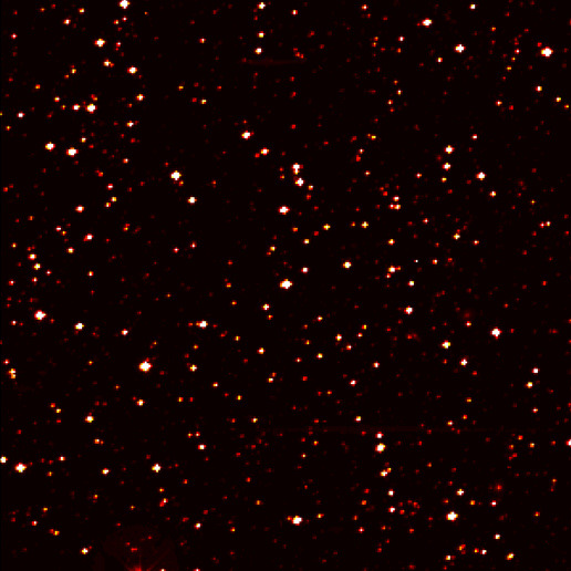
This image zooms into a small portion of Kepler's full field of view -- an expansive, 100-square-degree patch of sky in our Milky Way galaxy. (NASA/Ames/JPL-Caltech)
[/caption]
Mainstream media (MSM) is funny. Well, maybe funny isn’t the right word, especially when they hose things up and create a story when there really isn’t one. Or when they miss the real story. MSM recently succeeded in spades on both accounts in regards to the Kepler mission. Just last month, the Kepler team announced they had found over 750 candidates for extrasolar planets, and 706 of these candidates potentially are planets from as small as Earth to around the size of Jupiter, with the majority having radii less than half that of Jupiter. This is such incredible news, especially when you factor in that the data was from just 43 days of observations! But MSM seemed to miss all this and instead focused on the fact that the Kepler team got approval from NASA to keep over half of their data for an additional six months to verify and confirm their findings, rather than releasing all of it, as per NASA’s standard policy which requires astronomers to release their data from publicly funded instruments in one year. Then over this past weekend, from a TED talk by Kepler co-investigator Dimitar Sasselov, MSM finally realized that Kepler has found a boat-load of potential Earth-sized exoplanets. Well, yes. That’s what they said in June.
But then MSM took things out of context and exaggerated just a tad.
Even though in his talk, Sasselov used the words “potential” and “candidates” and said the planets are “like Earth, that is, having a radius smaller than twice Earth’s radius,” MSM reported news that NASA has found rocky planets with land and water.
And now some people are saying that Sasselov “leaked” the proprietary Kepler data, and some say he is in trouble for doing so. Today, the Kepler team said via Twitter that they are “working hard to thoughtfully respond to the media flurry surrounding the TEDGlobal talk.”
Let me use one of my mother’s favorite admonitions: For Pete’s sakes!
Watch the TED talk. In my opinion, Sasselov does a good job of getting people excited about exoplanets and he doesn’t say we have actually found another Earth. He also does a good job of presenting what the Kepler team has found without revealing any really huge proprietary data, even though he used this graph:
Screenshot from Sasselov's TED talk.
But really, this is pretty much what the Kepler team said in June, that they expected half of the 750 planet candidates would turn out not to be planets, and a fair number of those might be Earth-sized. The graph takes into account the amount of potential planets that Kepler found, plus the planets found previously by other telescopes and missions.
While it is exciting to think about the potential of finding Earth-sized and maybe even Earth-like planets, we’re likely a long way off from actually finding and then actually confirming another Earth. Additionally, right now, we’re only capable of finding planets that orbit relatively close to their parent star, which most likely wouldn’t put them in the “Goldilocks Zone” of being habitable.
You can read our original article from June here, where the Kepler team announced their findings. There’s also an explanation there of why the team requested to keep part of their data for an extra six months.
UPDATE: 10 pm Tuesday: Sasselov has written an blog post at the Kepler website, bascially saying that there is a big difference between Earth-sized and Earth-like. You can read it here.
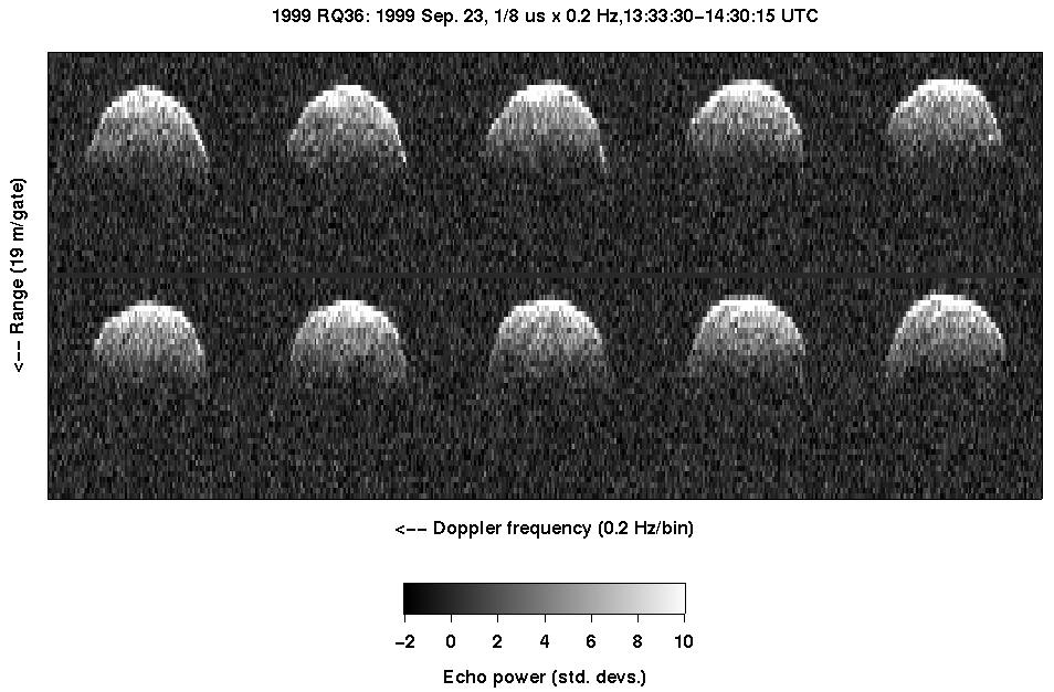
Doppler data on asteroid 1999 RQ36 from Goldstone. Credit: NASA
[/caption]
Asteroid trackers from Spain have upgraded the chance that asteroid 1999 RQ36 could hit our planet, saying it now has a one-in-a-thousand chance of impacting the Earth in the year 2182. Previous estimates gave a 1 in 1,400 chance that this asteroid could strike Earth sometime between 2169 and 2199. Currently, however, NASA’s Near Earth Object website gives between a 1 in 3,850 and a 1 in 3,570 chance that 1999 RQ35 could potentially impact Earth on Sept. 24, 2182. To make everyone breathe a little easier, that’s a 99.97200000% chance the asteroid will completely miss the Earth.
1999 RQ36 is an asteroid that has been suggested for a robotic sample return mission, to help us learn more about the makeup of NEOs, especially those that have a potential threat to Earth.
The team from Spain, co-led by María Eugenia Sansaturio from Universidad de Valladolid, said knowing this asteroid poses a potential threat in the twenty-second century “may help design in advance mechanisms aimed at deviating the asteroid’s path.”
“The total impact probability of asteroid ‘(101955) 1999 RQ36’ can be estimated in 0.00092 -approximately one-in-a-thousand chance-, but what is most surprising is that over half of this chance (0.00054) corresponds to 2182,” said Sansaturio.
Sansaturio and team have estimated and monitored the potential impacts for this asteroid through 2200. Asteroid 1999 RQ36 was discovered in 1999, but originally was not considered dangerous. In 2009, researches from Italy said their new calculations and observations revealed a chance of impact sometime during a 30 year span in the mid-to late 2100’s. Read that 2009 paper here.
1999 RQ36 is estimated to be about 560 meters wide, more than twice the size of the more well-known asteroid Apophis, which is projected to have a 1 in 250,000 chance of impact in 2036, reduced from the 1 in 45,000 odds calculated earlier. That asteroid is expected to make a record-setting — but harmless — close approach to Earth on Friday, April 13, 2029, when it comes no closer than 18,300 miles above Earth’s surface.
Artist's concept of the OSIRIS-REx spacecraft collecting a sample from asteroid 1999 RQ36. Credit: NASA
Of course, there is a fair amount of orbital uncertainty, due to the gravitational influences on the asteroid when it passes by the Earth and other objects, plus a minimal amount of influence from the Yarkovsky effect, which is an unbalanced thermal radiation from sunlight hitting one side of the asteroid and not the other that produces a tiny acceleration.
This effect had not been measured for 1999 RQ36 until now. The new research, published in the journal Icarus, predicts what could happen in the upcoming years considering this effect. Up until 2060, the team says the divergence of the impacting orbits is moderate; between 2060 and 2080 it increases 4 orders of magnitude because the asteroid will approach the Earth in those years; then, it increases again on a slight basis until another approach in 2162, it then decreases, and 2182 is the most likely year for the collision.
“The consequence of this complex dynamic is not just the likelihood of a comparatively large impact, but also that a realistic deflection procedure, or path deviation could only be made before the impact in 2080, and more easily, before 2060,” said Sansaturio.
“If this object had been discovered after 2080, the deflection would require a technology that is not currently available,” added Sansaturio. “Therefore, this example suggests that impact monitoring, which up to date does not cover more than 80 or 100 years, may need to encompass more than one century. Thus, the efforts to deviate this type of objects could be conducted with moderate resources, from a technological and financial point of view.”
The research also involved scientists from the University of Pisa (Italy), the Jet Propulsion Laboratory (USA) and INAF-IASF-Rome (Italy).
The proposed robotic mission to this asteroid is called OSIRIS-Rex, the Origins, Spectral Interpretation Resource Identification, and Security, Regolith Explorer, one of three proposals selected by NASA in December 2009 for more study under its New Frontiers program. If chosen the mission would launch in about 2018, and it could provide information about how the solar system was born, and perhaps, shed light on how life began. It also might be one of the first looks at how an asteroid might be deflected. Read more about this proposed mission on the NASA Goddard website.
Lots of sites have posted this recently, but it is so good it’s worth showing up one more time on the interwebs. This is a clip from a British comedy show “That Mitchell and Webb Look,” that debunks the notion that the Moon landings were faked, in a way that only British TV can!
My good friend (and forum co-admin) Phil Plait has been working on a super secret project for a few months. But now the project has been revealed in all its glory… it’s a television show called “Bad Universe“. Phil made the announcement a couple of days ago, but had to remove the video for technical purposes (or perhaps it’s a vast conspiracy). Anyway, the trailer’s back online, so now you can check it out.
Nancy and I thought Universe Today was getting a little long in the tooth – its design was so 2008 – so we updated it. Hurray! The goal here was simplicity, so we’ve cleaned things up, threw things out that didn’t really matter any more, and tried to give it a hip 2010 look.
Of course, we broke all kinds of things, which now need fixing. So if you see any problems, font strangeness, or stuff that just looks plain ugly, post a comment below, or drop me an email ([email protected]) and I’ll see what I can do to fix it.
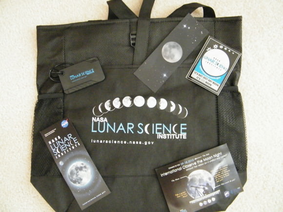
I attended the NASA Lunar Science Institute’s Annual Lunar Forum last week, and the wonderful people from NLSI provided a very cool bag of goodies — including a great backpack/bag with the NLSI logo, a bookmark, luggage nametag, lanyard (including an official PRESS badge!), stickers and other informational handouts. We’re giving this prize package away to one of our readers! Just send an email to [email protected] and put “Lunar Science” in the subject line. We’ll do a random pick from all the emails we get. Submit an email by Monday, August 2 at 12:00pm PDT.
Just a few short years ago, even the thought of capturing an astronomy anomaly with what’s considered an “amateur telescope” was absolutely unthinkable. Who were we to even try to do what great minds postulated and even greater equipment resolved? I’ll tell you who… Bernhard Hubl. Come on inside to meet him and see what he can do!
One of the first great minds to consider the effects of gravitational lensing was Orest Chwolson in 1924. By 1936, Einstein had upped the ante on its existence with his theories. A year later in 1937, the brilliant Fritz Zwicky set the idea in motion that galaxy clusters could act as gravitational lenses. It was not until 1979 that this effect was confirmed by observation of the so-called “Twin QSO” SBS 0957+561… and now today we can prove that it can be observed with a 12″ telescope under the right conditions and a lot of determination.
Bernhard Hubl of Nussbach, Austria is just the kind of astrophotographer to try to capture what might be deemed impossible. “Abell 2218 is a galaxy cluster about 2.1 billion light-years away in the constellation Draco. Acting as a powerful gravitational lens, it magnifies and distorts galaxies lying behind the cluster core into long arcs, as predicted by the General Theory of Relativity.”
Say’s Berhard, “I wanted to know, if I could detect signs of these arcs with a 12″ Newtonian at f=1120mm. After over 12 hours of exposure time under excellent conditions, I know that this is a hard job, but I am glad that I could identify the three brighter arcs.”
And so are we!
Many thanks to Bernhard Hubl for his outstanding sense of curiosity and excellent astrophotography… and to the NorthernGalactic community for the heads up!
If there’s only one thing we’ve learned from all the highly successful recent Moon missions – the Lunar Reconnaissance Orbiter, LCROSS, Chandrayaan-1 and Kaguya — it’s that the Moon is perplexingly different from our perceptions of the past 40 years. The discovery of water and volatiles across the surface and in the permanently shadowed regions at the poles changes so many of the notions we’ve had about Earth’s constant companion. Basically, just within the past year we’ve realized the Moon is not a dry, barren, boring place, but a wetter, richer and more interesting destination than we ever imagined. And so, the proposal for NASA to effectively turn away from any human missions to the Moon, as well as Administrator Charlie Bolden’s ‘been there, done that’ comments is quite perplexing – especially for the lunar scientists who have been making these discoveries.
“It’s been quite a year for the Moon,” said Clive Neal, a lunar geologist from Notre Dame, speaking last week at the NASA Lunar Science Institute’s annual Lunar Forum at Ames Research Center. “And things got quite depressing around February 2010.”
That’s when President Obama proposed a new budget that effectively would end the Constellation program and a return to the Moon.
At the Forum, lunar scientists shared their most recent findings – as well as their attempts to model and comprehend all the data that is not yet understood. But they saved any discussion of NASA’s future until the final presentation of the meeting.
“Hopefully this talk will stop you from running out of here ready to hang yourself or slit your wrists,” quipped Neal, who led the final session.
The week began, however, with keynote speaker Andrew Chaikin – author of the Apollo ‘bible,’ “A Man on the Moon,” and several other space-related books — saying, “We have to erase that horrendous ‘been there done that’ notion.” Chaikin also shared a famous Peanuts cartoon showing Lucy pulling the football out from under from Charlie Brown. No caption was needed for everyone to understand to what Chaikin was referring.
“With all of these new discoveries, we should have ample reason to believe that humans will follow,” said Chaikin. But right now, he added, the man in the Moon looks a little like Rodney Dangerfield. “The Moon wants – and deserves – respect.”
“It appears NASA’s focus might be shifting to Near Earth Objects,” said Neal, “but the Moon is the nearest Near Earth Object. It’s quicker, safer and cheaper to get humans there, and the important thing to recognized that there’s a lot left to explore, and a lot to do on the Moon.”
Only 5% of the Moon’s surface has been explored by humans, and Neal showed scaled maps of the Apollo landing sites overlaid on maps of Africa, Europe and the US, revealing just how small a portion of the Moon has been explored directly by humans. The map below shows the Apollo 11 crew’s movement on the Moon can fit within the size of a soccer (football) field.
Apollo 11 VS. a soccer (football) field. Credit: NASA History website. Click for larger version.
Additionally, the latest data reveal that the Apollo sites were in no way representative of the entire Moon.
In light of the proposed plan to give up on the Moon, Neal said there probably is a lot of misperceptions by the American public, as well as in other countries that there’s nothing to do or learn at the Moon. But he believes nothing could be further from the truth.
“What we’ve heard over the last couple of days are fantastic talks and seen wonderful posters in regard to the vibrancy of lunar exploration and science, and seen that exploration enables science and that science enables exploration. The Moon is a Rosetta Stone for solar system exploration and science. The recognition of a possible lunar magma ocean has resulted in terrestrial and Martian magma oceans being proposed. This could be the way terrestrial planets evolve and the Moon is begging us to go back and explore to figure that out.”
There’s also the studies of preserved impacts on the lunar surface which represents a look back in time where we can figure out how to do date planetary surfaces, test cataclysm hypotheses, and study how airless bodies undergo space weathering, which has a direct application to NEO research. Studying cold trap deposits has direct applicability to learning more about the planet Mercury, and lunar regolith contains information about the history of our Sun.
There are proposals for doing radio astronomy from the lunar farside, which will probe the dark ages of the Universe and look back to when the first stars turned on. “So the Moon is a gateway to the Universe,” Neal said. “You can do so much more with the moon — its not just the moon, it’s the solar system and beyond.”
In addition there are many unresolved scientific questions about the Moon. What are the locations and origins of shallow Moon quakes, and large lunar seismic events? How does the lunar regolith affect transmission of seismic energy? What is the nature of the lunar volatiles in the permanently shadowed regions at the lunar poles? What is the mechanism for the adsorption of water, hydroxyl and other minerals recently found on the Moon’s surface? What is nature of lunar core?
When Constellation was proposed, returning to the Moon was said to be a testbed for going on to Mars. It would be a safe and more economical way to test out systems and technology needed for going to the Red Planet. So, what has changed?
Primarily the budget. There weren’t enough funds in Constellation’s coffers to go to the Moon and then Mars. It primarily became a Moon-only program, which many said, didn’t bring us to the “real” destination that everyone really wants: Mars.
And money is still the real issue for not returning to the Moon in the new proposals of going to NEO’s and then Mars. If money weren’t an object, we’d do it all.
But the Moon offers a great local to test out human missions to Mars. “The Moon offers one-sixth of Earth’s gravity,” Neal said,” and we do not know what happens to the human body over time in that gravity, and we can only extrapolate what happens there and on Mars’ one-third gravity. We could test out life support, the growth of crops, the radiation environment and more. The ‘feed forward’ there is quite important where you can simulate a Mars mission on Moon. To develop and test your radiation shielding in the real environment on the Moon is more of a test than flying on the space station.”
Both Neal and Chaikin said they could go on and on about the benefits of returning to the Moon, and they also book-ended the Lunar Forum by saying it is up to the lunar scientists and Moon enthusiasts to educate the public, other scientists and even NASA about the importance of the Moon.
“We have to do a better job of educating the public – even dealing with the conspiracy theorists,” Neal said. “We need to get into schools and educate about what NASA has done, and what they are doing now. We all take responsibility for that.”
“The Moon is not going to get the respect it deserves unless people are out there talking about it,” said Chaikin.
Artists concept of a space elevator. Credit: Caltech
[/caption]
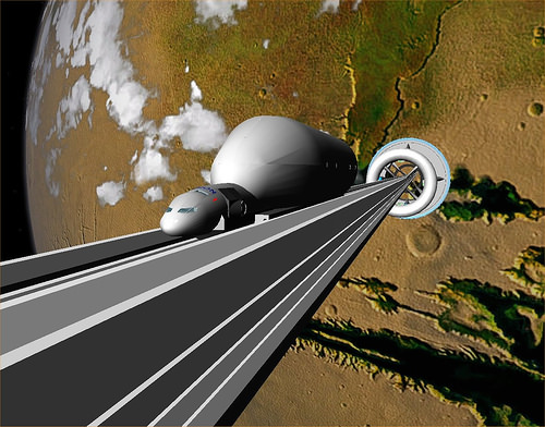
After our recent article featuring the concept of a lunar elevator, many of you posted questions about both lunar elevators and space elevators in general. Liftport’s Michael Laine has graciously agreed to provide answers for these questions, and if anyone has additional questions, leave them in the comment section here. We’ll post Michael’s answers in a subsequent post.
For those of you who have really big questions, you may want to attend the first lunar elevator workshop in Seattle, Washington this coming weekend, July 29-August 1 in Seattle Washington. See this link for more information.
And there’s also a space elevator conference August 13-15 at the Microsoft Conference Center in Redmond, Washington. Find more details at this link.
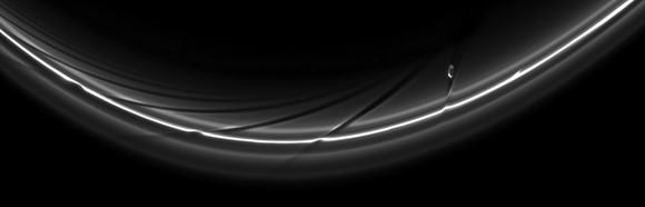
Saturn's moon Prometheus creates streamer channels in the planet's rings. Credit: NASA/JPL/Space Science Institute
[/caption]
I’ve frequently said the Cassini spacecraft is an artist, so when Carolyn Porco, the mission’s imaging team lead, mentioned on Twitter that Saturn’s moon Prometheus is akin to Michelangelo, I had to take a look. Wow, this gorgeous image is suitable for framing! Visible in the perturbed, thin F ring, is the potato-shaped Prometheus, and having performed the perturbing, it continues in its orbit. Click the image for the super-huge version.
Prometheus (148 kilometers, 92 miles across) periodically creates streamer-channels in the F ring, and the moon’s handiwork can be seen as the dark channels. Here’s a movie made from Cassini images showing this process:
The image was taken in visible light with the Cassini spacecraft narrow-angle camera on June 1, 2010. A star is also visible through the rings near the center right of the image.
There are also some additional features in the F ring, courtesy of Prometheus.
This Cassini image shows icy particles in Saturn’s F ring clumping into giant snowballs as the moon Prometheus makes multiple swings by the ring. Scientists say that the gravitational pull of the moon sloshes ring material around, creating wake channels that trigger the formation of objects as large as 20 kilometers (12 miles) in diameter.
“Scientists have never seen objects actually form before,” said Carl Murray, a Cassini imaging team member based at Queen Mary, University of London. “We now have direct evidence of that process and the rowdy dance between the moons and bits of space debris.”


 field. Credit: NASA History website. Click for larger version")