NASA’s Shuttle Program Hands Over Launch Pad to Constellation

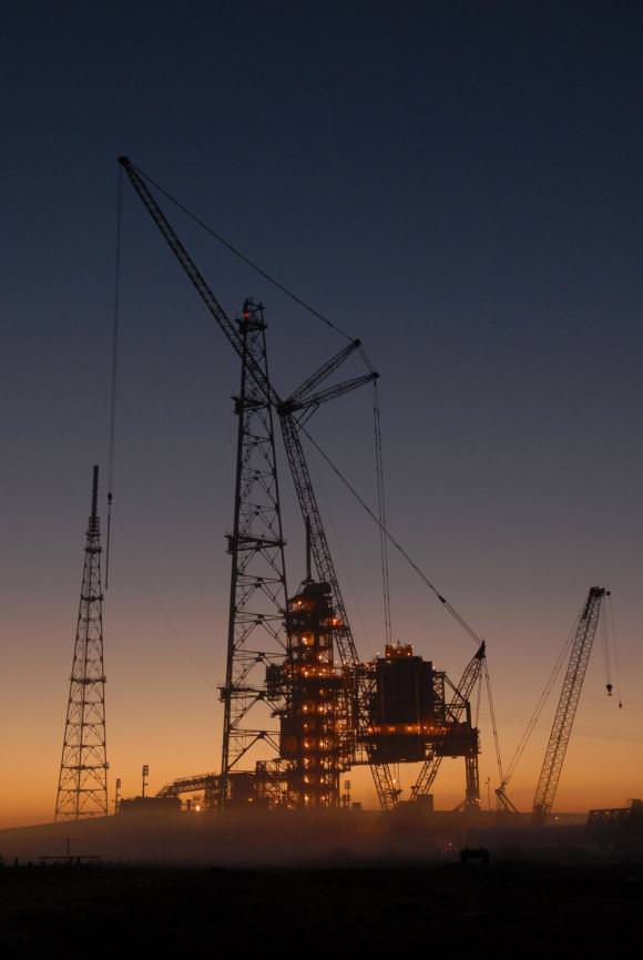
Contruction on launch pad 39B. Credit: NASA

[/caption]
It’s the end of an era, as Launch Pad 39B at Kennedy Space Center has been officially handed over to the Constellation Program. The handover took place Sunday after space shuttle Endeavour was moved to Launch Pad 39A. The ground operations team will finish modifying pad B for in time for first flight test of the Ares I-X rocket, currently scheduled for around August 30 of this year. Modifications will include removing the orbiter access arm and a section of the gaseous oxygen vent arm and installing access platforms and a vehicle stabilization system.

Since the late 1960s, pad B has been instrumental in human spaceflight programs. Originally, the pad was built for the Saturn V rockets for the Apollo flights to the moon, as well as flights to launch the Skylab space station and to send three crews to live on board. It also saw the launch of the Apollo spacecraft that was part of the Apollo Soyuz test program, where spacecraft from the US and USSR docked in space. In the 1980’s the pad was refitted for the space shuttle. Pad 39B was not ready until 1986, and the first Shuttle launch to use it was the ill-fated STS 51-L flight – the Challenger Disaster.

But now it’s time for the next generation of spacecraft and launch system. The Constellation Program is developing the Ares I and Ares V launch vehicles, the Orion crew capsule, and the Altair lunar lander — to carry humans to the International Space Station, the moon and beyond.

More info on Constellation

More info on the Ares I-X

Mount Merapi

Mount Merapi

[/caption]
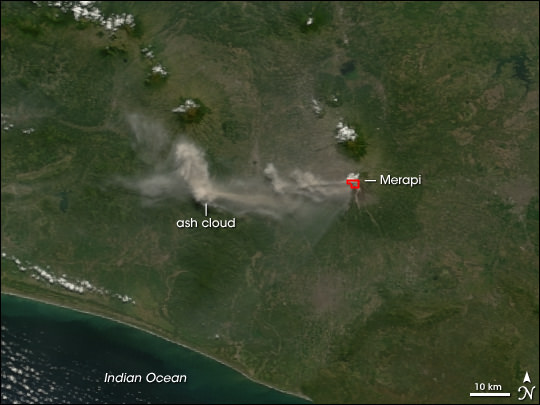
Mount Merapi is an active volcano in Indonesia, on the island of Java near the city of Yogyakarta. The volcano is so active that smoke can be seen coming out of the peak almost every day of the year. Mount Merapi has been erupting regularly since 1548.

Mount Merapi is located in the subduction zone, where the Indo-Australian Plate is going under the Eurasian Plate. Geologists estimate that the volcano started forming 400,000. It was largely built up by basaltic lava flows, but the lava flows have become more viscous in the last 10,000 years or so. With the thicker lava, Merapi has had more explosive eruptions and the formation of lava domes. Merapi has minor eruptions every 2 years or so, and major eruptions every few decades.

Even though it’s an extremely active volcano, thousands of people live on its flanks. Hot gas killed 43 people in 1994, and 13 villages and 1400 people were killed by pyroclastic flows during an eruption in 1930. A series of earthquakes struck Mount Merapi in April/May 2006, the most powerful one on May 27th killed 5,000 people. An eruption on June 14, 2006 spewed out a cloud of volcanic ash that covered a village several kilometers away.

We have written many articles about volcanoes for Universe Today. Here’s an article about Mount Pinatubo, and here’s an article about Mount Tambora.

Want more resources on the Earth? Here’s a link to NASA’s Human Spaceflight page, and here’s NASA’s Visible Earth.

We have also recorded an episode of Astronomy Cast about Earth, as part of our tour through the Solar System – Episode 51: Earth.

Mount Tambora

Mount Tambora

[/caption]
Mount Tambora is an active stratovolcano on Sumbawa island in Indonesia. It once measured 4,300 meters tall, making it one of the tallest mountains in Indonesia. It’s most famous for an enormous eruption in 1815, when the volcano detonated in the most powerful eruption in recorded history. After 150 cubic kilometers were blasted out of the volcano, and the caldera collapsed, Tambora had dropped down to 2,700 meters.

Tambora had only 3 eruptions over the previous 5,000 years, and none were very severe. But in 1812, Mount Tambora became much more active, culminating in a series of eruptions in April, 1815. On the evening of April 10th, 1815, witnesses saw three huge columns of flame rising up from the volcano. Pumice rocks rained down around the volcano, followed by clouds of ash a few hours later.

Geologists have estimated that Mount Tambora erupted with a force of 7 on the Volcanic Explosivity Index; that’s 4 times more powerful than the 1883 Krakatoa eruption. The ash cloud reached Borneo and Sulawasi islands, located 1,300 kilometers away. Historians argue how many deaths caused by the eruption itself, but estimates range from 10,000 killed by the eruption outright to almost 100,000 when you include the disease and starvation after the eruption.

The effects from the Mount Tambora eruption were felt around the world. It released so much sulphur into the atmosphere that the entire planet was cooled. The following year was known as the year without a summer. Snow fell in Quebec in the middle of summer, and persistent fog obscured much of the Northeastern US. Average annual temperatures dropped by 0.4 to 0.7 degrees C. It created the worst famine in the 19th century.

We have written many articles about volcanoes for Universe Today. Here’s an article about Mount St. Helens, and here’s another about Mount Pinatubo.

Want more resources on the Earth? Here’s a link to NASA’s Human Spaceflight page, and here’s NASA’s Visible Earth.

We have also recorded an episode of Astronomy Cast about Earth, as part of our tour through the Solar System – Episode 51: Earth.

Ice on the Moon? NASA, ISRO May Collaborate to Find Out

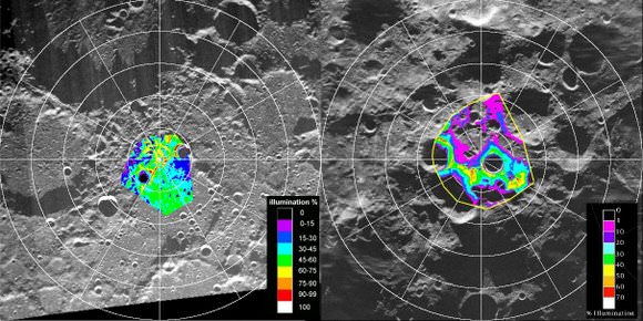
Maps of the lunar poles from the Clementine mission. Credit: NASA

[/caption]
The debate has endured since the early 1960’s: could there be water ice hiding in deep, dark craters near the Moon’s poles, left untouched by sunlight? Several spacecraft orbiting the moon have tried to peer into these craters to find out, but so far no definitive data has been obtained either way. But now NASA and the Indian Space Research Organization (ISRO) are looking to team up two spacecraft to try and answer the question once and for all. “When it happens, it is going to be a unique experiment and will be the first of its kind,” said Dr. Mylswamy Annadurai, project director for the Chandrayaan-I orbiter.

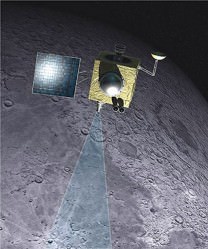
ISRO’s Chandrayaan-I, already in lunar orbit and NASA’s Lunar Reconnaissance Orbiter (LRO), scheduled to launch later this month would be maneuvered to orbit simultaneously over the lunar poles, and the data from the both spacecrafts’ radar instruments would be shared and exchanged. Details of the collaboration are still being worked out, but officials hope to finalize the plans within a month.

Artist concept of Chandrayaan-1 orbiting the moon. Credit: ISRO

The master plan for the experiment was developed Paul Spudis of the Lunar and Planetary Institute of Houston, who also led the team of US scientists in the Chandrayaan-I project.

“Our experiment should answer first the broad questions about the existence of lunar polar ice, its extent and purity,” Spudis wrote in his paper published in Lunar and Planetary Science journal.

As the first step, on May 19 ISRO scientists shifted Chandrayaan-I to a new orbit 200 km away, lifting it from the 100 km orbit it had been in previously.

“In contrast to some recent claims, this debate is still open and nothing has occurred in the last few years to cause participants in the debate to abandon their positions,” Spudis wrote in an article for the National Space Society in 2006. “No single piece of evidence for lunar ice is decisive, but I think the preponderance of evidence indicates that water ice exists in permanently dark areas near the poles.”

Finding ice in the moon’s polar region would be significant in many respects. The ice could be an abundant water source for future colonists on the moon, as well as being used for producing propellants. However, Spudis said that although polar ice is important, it is not a requirement to successfully live and work on the Moon.

Additionally, any ice on the moon would hold clues to the evolution of the solar system, as the water was likely the product of comets that crashed onto the moon over a billion years ago.

Sources: Bharat Chronicle, NSS

Have Astronomers Discovered A New Type of Supernova?

[/caption]

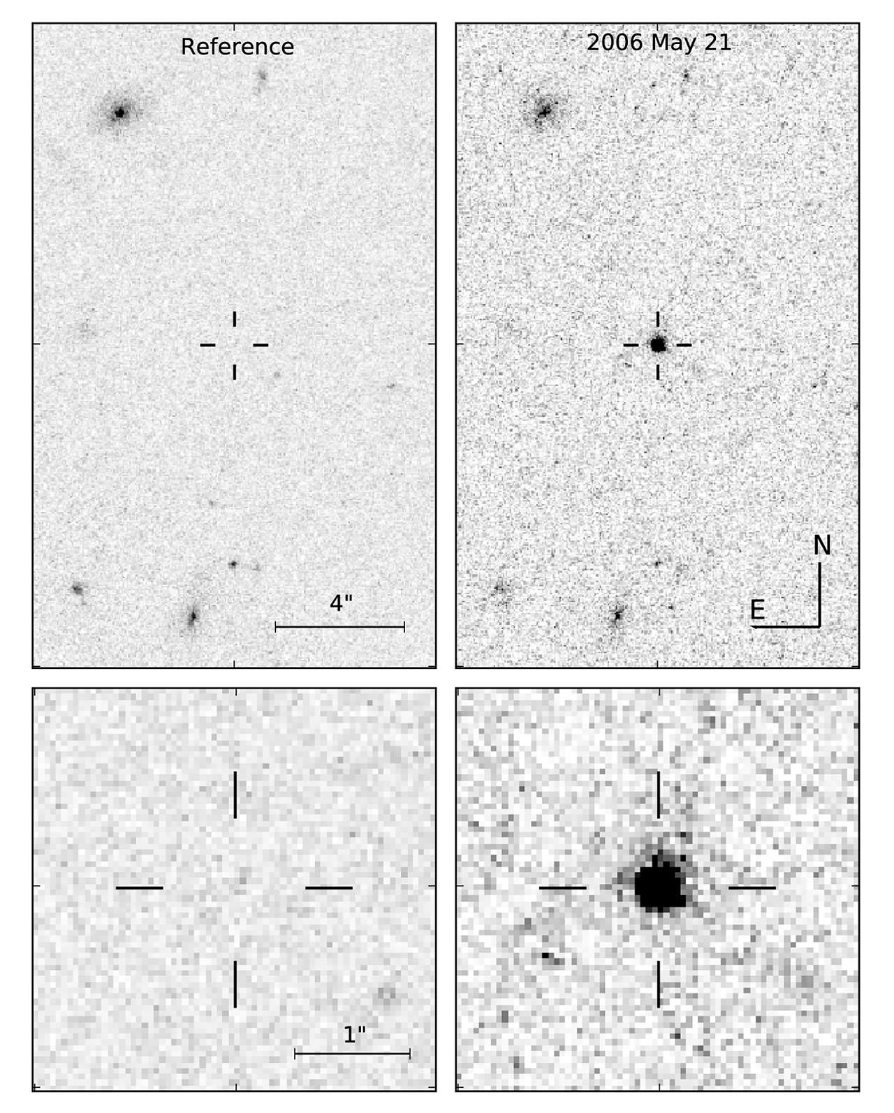
A team of astronomers at the University of Warwick think they’ve finally explained what caused the bizarre transient object SCP 06F6.  By comparing the optical spectrum of SCP 06F6 to that of carbon-rich stars in our own galaxy, the team concludes the sudden outburst was not a low-energy local event but a supernova-like explosion within a cool carbon-rich atmosphere some 2 billion light years away.  If they’re right, it means the collapse of carbon-rich stars may lead to supernovae unlike any yet seen.

First observed in 2006 by U.S. researchers on images from the Hubble Space Telescope, SCP 06F6 flashed suddenly then faded from view over some 120 days.  The U.S. team published their findings in September 2008.  But they had no idea what might cause this outburst.  The event was so unusual, if fact, that astronomers had didn’t know whether SCP 06F6 was located in our own galaxy or at the other end of the universe.  Talk about experimental uncertainty!

The Warwick team noticed the optical spectrum of SCP 06F6 looked a lot like light from cool stars with molecular carbon in their atmosphere.  But to get a close spectral match with SCP 06F6, the team had to apply a redshift to the spectra of the carbon stars to correspond to a rapidly receding object some 2 billion light years away.  The large distance and the sudden appearance of SCP 06F6 suggest the object may be related to the sudden collapse of a carbon-rich star.  If so, it’s a brand new type of supernova.

But questions remain.  SCP 06F6 seems to be alone in space… it has no known visible host galaxy.  And the 120-day time scale of the object’s rise and fall in brightness is four times longer than most Type-II supernovae (the kind caused by the core-collapse of a massive star).

What’s more, X-ray observations by the European satellite XMM-Newton show the object blasts out up to 100 times more X-rays energy than expected from a typical Type-II supernova.

The strong X-ray emission may suggest the star was ripped apart by a black hole rather than exploding on its own.  But according to Boris Gansicke, the lead researcher of Warwick team, “The lack of any obvious host galaxy for SCP 06F6 would imply either a very low black hole mass (if black holes do exist at the centres of dwarf irregular galaxies) or that the black hole has somehow been ejected from its host galaxy. While neither is impossible, this does make the case for disruption by a black hole somewhat contrived.”

The findings were published in the June 1, 2009 issue of Astrophysical Journal Letters.

Source:  University of Warwick

Also see the Universe Today article about the discovery of SCP 06F6

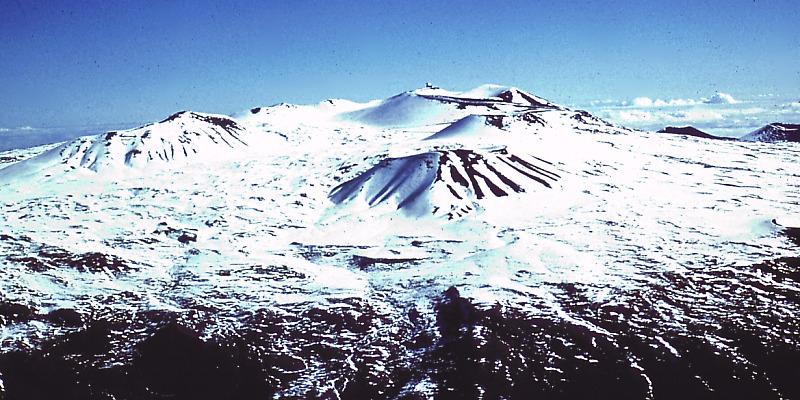
Mauna Kea

Mauna Kea. Image credit: USGS

[/caption]
The shield volcano Mauna Kea is the tallest volcano on Earth, rising to a summit of 4,205 meters above sea level. It’s one of the 5 volcanoes that make up the Big Island of Hawaii. Mauna Kea means “white mountain” in the Hawaiian language because its summit is regularly covered in snow during the winter.

Scientists believe that Mauna Kea began erupting about 1 million years ago. It’s fed by magma from the Hawaiian hotspot; a volcanic vent that continues to pump out magma while the Pacific Plate slowly moves over top of it. This has created a chain of islands thousands of kilometers long called the Hawaiian archipelago. It’s believed that Mauna Kea transitioned from an active volcano to a post-shield stage of volcanic evolution about 200,000 to 250,000 years ago. The last eruption was thought to have occurred about 4000-5000 years ago.

Because of its high altitude, the peak of Mauna Kea is an excellent spot for astronomical observing. The summit of the volcano is above 40% of the Earth’s atmosphere, and 90% of the water vapor, allowing for extremely clear skies. Some of the largest, most powerful telescopes in the world are located atop Mauna Kea, including the Keck observatories, and the Gemini North telescope.

During the winter, Mauna Kea is coated in a thin layer of snow, and there are regions on the mountain where you can ski or snowmobile. And scientists have discovered evidence that large glaciers formed during the last period of world wide glaciation – about 11,000 years ago.

We have written many articles about volcanoes for Universe Today. Here’s an article about Mauna Loa, and here’s an article about Kilauea.

Want more resources on the Earth? Here’s a link to NASA’s Human Spaceflight page, and here’s NASA’s Visible Earth.

We have also recorded an episode of Astronomy Cast about Earth, as part of our tour through the Solar System – Episode 51: Earth.

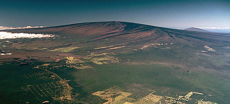
Mauna Loa

Mauna Loa. Image credit: USGS

[/caption]
Earth’s largest volcano is Mauna Loa, located on the Big Island of Hawaii. Although it only rises 4 km above the surface of the Pacific Ocean, that’s just the tip of the iceberg. Mauna Loa descends another 5 km down to the sea floor, which has been pushed down another 8 km by the mass of Mauna Loa. When you add that all up, the summit of Mauna Loa is 17 km above its base. It’s not the tallest volcano on Earth, though, it’s actually 37 meters shorter than Mauna Kea.

Half of the island of Hawaii is made up by Mauna Loa, and it amounts to 85 percent of all the other Hawaiian islands combined. Scientists believe that Mauna Loa has been erupting for at least 700,000 years, and may have emerged above sea level 400,000 years ago. Furthermore, Mauna Loa is one of the world’s most active volcanoes having erupted 33 times since detailed records began in 1843. Its most recent eruption was in 1984, and it’s almost certain to erupt again in the near future.

As with all of the Hawaiian volcanoes, Mauna Loa gets its magma from the Hawaiian hotspot. This is a chamber of magma that has created all the islands in the Hawaiian archipelago. The slow movement of the Pacific Plate has created a succession of volcanic islands that stretch thousands of km across the ocean. Nearby Mauna Kea is dormant, Mauna Loa is active and the smaller Kilauea is in an almost constant state of eruption.

Mauna Loa is a shield volcano. This means it has wide, gently sloping flanks. The basalt lava that erupts out of Mauna Loa and the other Hawaiian Islands has a high viscosity, and can flow for dozens of kilometers. Explosive eruptions on shield volcanoes are rare. Scientists have detected a magma chamber about 3 km below the surface of Mauna Loa, and smaller chambers beneath rift zones on the volcano’s flanks.

We have written many articles about volcanoes for Universe Today. Here’s an article about Kilauea, and here’s an article about Krakatoa.

Want more resources on the Earth? Here’s a link to NASA’s Human Spaceflight page, and here’s NASA’s Visible Earth.

We have also recorded an episode of Astronomy Cast about Earth, as part of our tour through the Solar System – Episode 51: Earth.

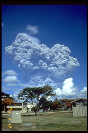
Mount Pinatubo

Mount Pinatubo is an active stratovolcano on the island of Luzon in the Philippines, and the site of one of the most powerful recent eruptions. In June 1991, the volcano produced the second largest terrestrial eruption of the 20th century (after Novarupta), and the largest eruption in living memory. At least 800 people lost their lives in the eruption, but this was lower than it could have been because of an organized evacuation effort.

Pinatubo is located in the Cabusilan Mountain range, located on the west coast of the Island of Luzon. It’s a stratovolcano made up of successive layers of andesite and dacite. Its richly forested slopes were home to several thousand indigenous people. Before the eruption, it rose to an elevation of 1745 meters, but now it’s only 1485 meters tall.

Scientists had many warnings that Pinatubo was about to erupt, and this allowed such a thorough evacuation. On July 16, 1990, a magnitude 7.8 earthquake struck about 100 km north of Pinatubo. And then in March/April 1991, molten rock was detected rising to the surface from more than 32 kilometers beneath Pinatubo. This triggered more small earthquakes through April, May and early June.

On June 12, 1991, millions of cubic meters of magma reached the surface, beginning several days of eruptions. Even more magma reached the surface on June 15th, ejecting more than 5 cubic kilometers of material. An ash cloud rose 35 kilometers into the air, covering the surrounding region in meters of ash. Dangerous pyroclastic flows of hot ash, rock and water surged down the sides of the volcano, destroying everything in their path. The huge eruption gouged out a caldera 2.5 km across.

The eruption was so significant that the ash darkened the atmosphere, and caused worldwide temperatures to drop by 0.5 degrees C.

We have written many articles about volcanoes for Universe Today. Here’s an article about Mount St. Helens, and here’s an article about Krakatoa.

Want more resources on the Earth? Here’s a link to NASA’s Human Spaceflight page, and here’s NASA’s Visible Earth.

We have also recorded an episode of Astronomy Cast about Earth, as part of our tour through the Solar System – Episode 51: Earth.

Newsflash: Sunspot Appears!

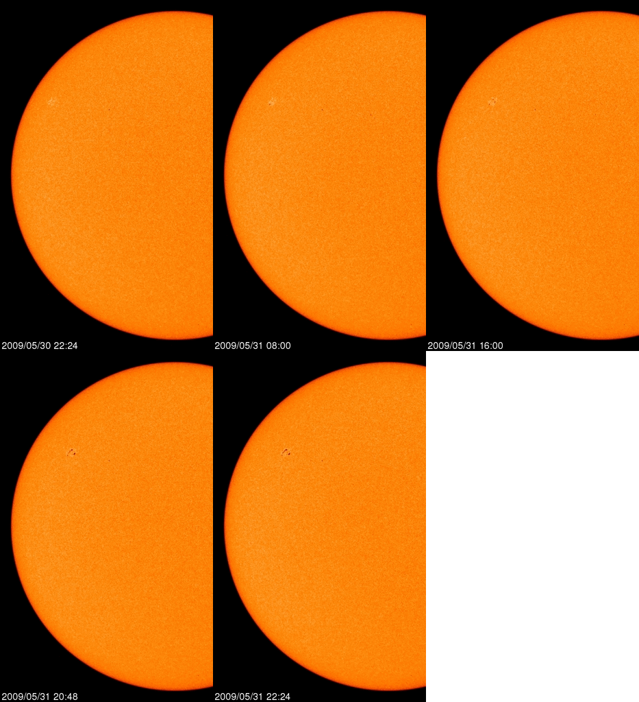
Sunspot animation of Sunspot 1019. Credit: Spaceweather.com

[/caption]
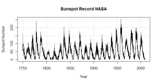
OK, I admit – the headline is a little over the top. But the sun has been so quiet of late, that even a small sunspot can be exciting. There’s been some debate whether this period of extreme solar calm is truly unusual, or just part of the natural cycle. But solar cycle models never predicted this low amount of activity. “It turns out that none of our models were totally correct,” admitted Dean Pesnell of the Goddard Space Flight Center, a member of an international panel of experts that are now trying to predict what the next solar cycle will hold. “The sun is behaving in an unexpected and very interesting way.”

The panel is predicting that the next cycle, Solar Cycle 24 will have a peak sunspot number of 90, the lowest of any cycle since 1928 when Solar Cycle 16 peaked at 78.
Sunspot cycles

Right now, the solar cycle is in a valley–the deepest of the past century. In 2008 and 2009, the sun set Space Age records for low sunspot counts, weak solar wind, and low solar irradiance. The sun has gone more than two years without a significant solar flare.

“In our professional careers, we’ve never seen anything quite like it,” says Pesnell. “Solar minimum has lasted far beyond the date we predicted in 2007.”

For 2009, the number of “spotless” days are 123, as of May 31, which is 82%.

There’s a little sign of action on the sun, though. In recent months small sunspots and “proto-sunspots” are popping up with increasing frequency. Enormous currents of plasma on the sun’s surface (“zonal flows”) are gaining strength and slowly drifting toward the sun’s equator. Radio astronomers have detected a tiny but significant uptick in solar radio emissions. All these things are precursors of an awakening Solar Cycle 24 and form the basis for the panel’s new, almost unanimous forecast.

According to the forecast, the sun should remain generally calm for at least another year. This calm has a greater affect on Earth’s atmosphere than you might imagine. With low solar activity, the Earth’s atmosphere can cool and contract. Space junk accumulates in Earth orbit because there is less aerodynamic drag; hence the increase in the number of collision event “alarms” for the ISS and shuttles. The calm solar wind whips up fewer magnetic storms around Earth’s poles. Cosmic rays that are normally pushed back by solar wind instead intrude on the near-Earth environment. There are other side-effects, too, that can be studied only so long as the sun remains quiet.

But the sun is a very chaotic place, and even a below-average cycle is capable of producing severe space weather from solar flares and coronal mass ejections (CME) said Doug Biesecker of the NOAA Space Weather Prediction Center. So we shouldn’t be lulled into a false sense of security.

Sources: Science@NASA, SpaceWeather.com

Mount St. Helens

Eruption of Mount St. Helens

[/caption]
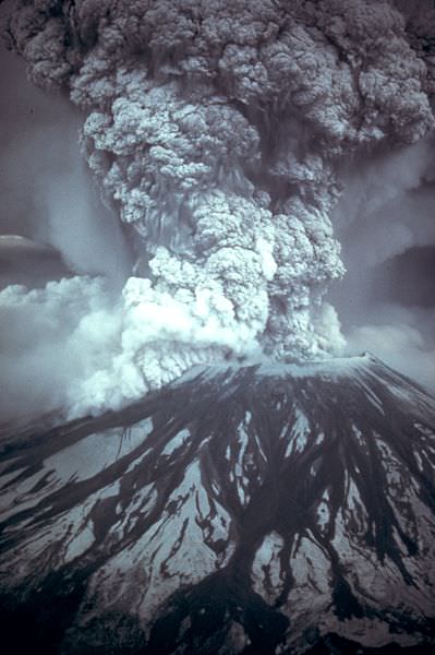
The most powerful and devastating volcanic eruption in the history of the United States was the explosion of Mount St. Helens. This active stratovolcano, located in Skamania County, Washington detonated on May 18, 1980, killing 57 people, destroying hundreds of homes, and flattening hundreds of square kilometers of forest. The eruption tore off the top of the mountain, reducing its height from 2,950 meters to 2,550 meters.

Mount St. Helens is just one volcano in the Cascade Range of mountains that stretch down the west coast of North America. There are many other famous volcanoes in this region, like Mount Ranier, Mount Hood, and Mount Shasta. Helens is a large eruptive cone made up of several layers of lava rock interlaced with ash, pumice and other deposits. There are layers of basalt and andesite, and several domes of dacite lava have broken through.

Scientists believe that Mount St. Helens started forming about 40,000 years ago, and it’s considered the most active volcano in the Cascade Range. Before its eruption, St. Helens was the 5th-highest peak in Washington state; it was nicknamed the Mount Fuji of America. It measures about 10 km across the base and rose about 1,500 meters above the surrounding landscape.

And so, on May 18, 1980, Mount St. Helens erupted catastrophically, after nearly 2 months of local earthquakes and steam eruptions – scientists measured more than 10,000 minor earthquakes leading up to the eruption. But it was a magnitude 5.1 earthquake on May 18th that caused the volcano’s bulging north flank to slide away in the largest landslide in recorded history. This released a huge blast of hot gas, steam and rock debris that swept downhill from the summit. This pyroclastic flow melted snow and ice on the mountain, which added to the torrent of material streaming down the river valleys leading from the volcano. A plume of ash rose 19 kilometers into the air, covering 57,000 square kilometers of the Western United States.

Mount St. Helens is still active, and scientists have discovered dozens of extrusions of thick, pasty lava. A new dome is taking shape. It’s now about 1,100 meters in diameter and 250 meters tall.

We have written many articles about volcanoes for Universe Today. Here’s an article about Kilauea in Hawaii, and here’s an article about Krakatoa.

Want more resources on the Earth? Here’s a link to NASA’s Human Spaceflight page, and here’s NASA’s Visible Earth.

We have also recorded an episode of Astronomy Cast about Earth, as part of our tour through the Solar System – Episode 51: Earth.

References:
http://vulcan.wr.usgs.gov/Volcanoes/MSH/May18/summary_may18_eruption.html
http://vulcan.wr.usgs.gov/Volcanoes/MSH/Publications/Bulletin1859/eruption_may18_1980.html