High School Students Discover Asteroid

250px-astronomy_amateur_3_v2.thumbnail.jpg

Here’s another wonderful example of how amateur astronomers can make important discoveries. Three high school students from Wisconsin discovered an asteroid while doing an astronomical observation project for a class in school. Connor Leipold, Tim Patika, and Kyle Simpson of The Prairie School near Racine were notified this week by the Minor Planet Center in Cambridge, Massachusetts that the object they discovered has been verified as an asteroid.

The students will have the opportunity to name the asteroid, temporarily designated as 2008 AZ28. They spotted the asteroid through telescopes located in New Mexico that operate remotely via the internet. The technology was provided through a project sponsored by Calvin College in Grand Rapids, Michigan.

As Fraser and Pamela commented on their Astronomy Cast episode about amateur astronomy, “Astronomy is one of the few sciences where amateurs make can meaningful contributions and discoveries.” And here’s proof. So the rest of you, go out there and start looking!

Original New Source: NewsDaily

Has a Signal from ET Really Been Detected?

ata-gregorian.thumbnail.jpg

Have you heard the news? A television station in Oakland California was reporting that researchers working with SETI@home discovered a signal believed to be from extraterrestrials. Is it true? Has the most important discovery is the history of humanity been made? Do we have definitive proof that there are aliens out there with interesting things to say to us?

No.

Actually, I was going to give this the big write up, but Phil beat me to the punch. So, I’ll just point you over at his coverage.

Carnival of Space #37

mercuryandsun.thumbnail.jpg

Another week, another Carnival of Space. This time, the lucky host is Colony Worlds.

Marvel at the latest images of Mercury. Learn about the rogue black holes that could be cruising through the galaxy. Wonder at what it might take to launch a true interstellar probe.

Click here to visit the Carnival of Space #37.

And if you’re interested in looking back, here’s an archive to all the past carnivals of space. If you’ve got a space-related blog, you should really join the carnival. Just email an entry to [email protected], and the next host will link to it. It will help get awareness out there about your writing, help you meet others in the space community – and community is what blogging is all about. And if you really want to help out, let me know if you can be a host, and I’ll schedule you into the calendar.

Finally, if you run a space-related blog, please post a link to the carnival of space. Help us get the word out.

A View of Mercury’s Far Side

messenger-1.thumbnail.png

Images and data are arriving from MESSENGER’s recent flyby of Mercury. Scientists from NASA and the Johns Hopkins Applied Physics Lab are pouring over high resolution images of the side of the planet that has never before been imaged by a spacecraft. From these images, planetary geologists can study the processes that have shaped Mercury’s surface over the past 4 billion years. Let’s take a look at some of the images snapped by MESSENGER on January 14:

This image was taken just 21 minutes after MESSENGER’s closest approach to Mercury, at a distance of only 5,000 kilometers (3600 miles). It shows a region about 170 km (100 miles) across. Visible are a variety of surface features, including craters as small as about 300 meters (about 300 yards) across. But the most striking part of the image is one of the highest and longest cliffs yet seen on Mercury. About 80 km (50 miles) long, it curves from the bottom center up across the right side of this image. Scientists say that great forces in Mercury’s crust must have thrust the terrain occupying the left two-thirds of the picture up and over the terrain to the right. An impact crater has subsequently destroyed a small part of the cliff near the top of the image.

MESSENGER at Mercury.  Image Credit:  Credit: NASA/Johns Hopkins University Applied Physics Laboratory/Carnegie Institution of Washington
This image shows a previously unseen crater with distinctive bright rays of ejected material from the impact extending outward, providing a look at minerals from beneath Mercury’s surface. A chain of craters nearby is also visible. Studying impact craters provides insight into the history and composition of Mercury. The width of the image is about 370 kilometers (about 230 miles), and was taken about 37 minutes after MESSENGER’s closest approach. This image is the 98th in a set of 99 images that were taken to create a large, high-resolution mosaic of this region of Mercury. Hopefully this anticipated mosaic will be released at a planned press conference on January 30.

MESSENGER at Mercury.  Image Credit:  Credit: NASA/Johns Hopkins University Applied Physics Laboratory/Carnegie Institution of Washington
As MESSENGER approached Mercury on January 14, 2008, about 56 minutes before the spacecraft’s closest encounter, the Narrow-Angle Camera captured this view of the planet’s rugged, cratered landscape illuminated by the Sun. Although this crater has been imaged before by Mariner 10, MESSENGER’s modern camera has revealed detail that was not well seen by Mariner including the broad ancient depression overlapped by the lower-left part of the Vivaldi crater. Its outer ring has a diameter of about 200 kilometers (about 125 miles). The image shows an area about 500 km 9300 miles) across and craters as small as 1 kilometer (0.6 mile) can be seen. It was taken from a distance of about 18,000 km (11,000 miles.)

The MESSENGER (Mercury Surface Space Environment Geochemistry and Ranging) Science Team has begun analyzing these high-resolution images to unravel the history of Mercury, as well as the history of our solar system.

Original News Source: MESSENGER Website

Regulating Traffic in the Final Frontier

debris.thumbnail.jpg

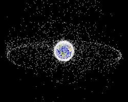
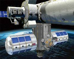
October of last year was the 50th anniversary of Sputnik, the first spacecraft to be launched into orbit. Since then, we’ve come a long, long way. Think of all the stuff that’s floating around our planet right now: GPS, television, and military satellites, the International Space Station and the Hubble telescope, and a host of debris. With more satellites and projects launching into space, the issue of regulating all of this space traffic is starting to become an issue.

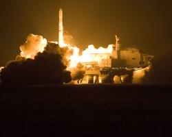
Current regulations of space come from a series of treaties and agreements between nations and organizations, starting with the Outer Space Treaty created 40 years ago. But with private companies like Virgin Galactic merging into space traffic, as well as nations like Japan, India, and China, launching satellites and scientific spacecraft, the need for a defined set of regulations is in order.

“While the current state can be regarded as a “piecemeal engineering”, space traffic management would provide a regulatory “big bang”. Space traffic management would not tackle single issues, but regard the regulation of space activities as a comprehensive concept. This concept is based on functionality, aiming at the provision of a complete set of rules of the road for the current and future way,” wrote Kai-Uwe Schrogl of the European Space Policy Institute in a paper titled “Space traffic management: The new comprehensive approach for regulating the use of outer space – Results from the 2006 IAA cosmic study,” published in the most recent issue of Acta Astronautica.

Space law would be concerned with four areas: keeping tabs on the current space traffic, a system of notification between nations or companies planning launches and missions to space, comprehensive rules for traffic to follow and a way to enforce these rules.

Tracking and notifying are both important to help keep spacecraft from crashing into each other, and would improve the performance of those satellites able to make avoidance maneuvers of space debris. The ISS and Hubble both do this on a regular basis, but other satellites lack the ability to change their orbit on a, so minimizing and tracking the amount of space debris – at least in certain high-traffic areas in Earth’s orbit – is instrumental.

The organizations and means of implementing these rules are still being debated. Possibilities include the creation of World Space Organization, or placing the responsibilities on the shoulders of the existing International Civil Aviation Organization, which currently regulates the skies closer to Earth.

Schrogl writes that a comprehensive space law is a ways off, but the debate about what rules are needed – and how to go about keeping the increasing number of parties launching into space in check – is currently picking up speed. This means that you shouldn’t expect to see any space police pulling over NASA’s Atlantis Shuttle for littering anytime soon.

Source: Acta Astronautica

Britain Proposes New International Space Station Modules

british-iss-hab.thumbnail.jpg

British scientists hope to improve living conditions on the International Space Station (ISS) by designing a new addition: the Habitation Extension Module (HEM). Although the plan is currently unofficial, it is hoped the proposal will get accepted and built for a 2011 launch. This would be a massive victory for UK space aspirations, as the nation currently does not have its own space agency and depends on project collaboration with the European Space Agency (ESA) to develop new space technology. The new HEM design features the UK national flag, the Union Jack, perhaps a symbol for the beginning of a British foothold in space.

The proposed habitat design would actually consist of two modules attached to the Node 3 segment of the station. Intended to provide extra accommodation for six crew members (the station currently holds a complement of three astronauts), this design should be welcomed as the ISS is scheduled to accommodate six people in 2009, signifying that the station will move into a “fully operational” phase of its construction.

As the Space Shuttle would have retired by the time HEM is sent to the station, launch will depend on the Russian Soyuz-Fregat rocket, and final approach to the station would use a built-in propulsion system. In addition to the module, three tons of supplies will be on board, stocking the ISS with food and equipment.

The proposed design will be 12.5 feet in diameter and 18.7 in length, adding a total of 3,531.5 cubic feet of living space. This 24% increase in space from the current living volume of 15,000 cubic feet would surely be a welcomed relief to the ISS occupants, making our only space station a more comfortable place to live and work.

The project would come with a pretty heavy price tag. Convincing the UK government to invest approximately £1 billion ($2 billion) in the construction and running of the module till 2015 might, however, stall the British desire for a strong presence in space.

 Source: Space.com

Sea Launch Rocket Success

sea_launch_zenit_3sl.thumbnail.jpg

After a year of silence, Sea Launch Co. is back in business, inserting a telecommunications satellite into orbit on January 15th. Almost a year ago, a Russian-Ukrainian built Zenit 3SL rocket, launching from the sea-based platform Odyssey, exploded, causing Sea Launch to halt business for the rest of 2007. On Tuesday the company could breath a sigh of relief as they saw the Zenit’s boosters light up the night sky…

It must have been a tough year for Sea Launch after the destruction of one of their rockets, loss of its payload (NSS-8, a Dutch telecommunications satellite) and damage to the launch platform, Odyssey. Sea Launch, a company specializing in commercial launches from a mobile launch pad, spent the last year making repairs to Odyssey (a converted oil rig) so five planned missions could go ahead as scheduled in 2008. The first was a resounding success and all going well, the accident last year wont put a dent in business for the future.

Sea Launch is currently the only sea-based launch company in the world. Launching rockets from a mobile launch platform has many advantages including:

  • Equatorial positioning – rockets launched at or near the equator provides a little extra “push” from the rotational velocity of the Earth, saving on energy required to reach orbit (saving fuel and therefore cost).
  • Safe location – away from populated areas, surrounded by water.
  • Flexible location – not restricted to a site prone to storms or geological instabilities.

There can be some drawbacks with sea-based launches. A launch planned in November 2007 had to be cancelled due to unusually strong ocean currents in the mid-Pacific launch site, so there can be some logistic issues when factoring in not only weather conditions but also ocean conditions. However, this week’s successful launch overcame the troubles of last year’s accident and managed to find calm conditions to send a Thuraya satellite (built by Boeing Satellite Systems International in El Segundo, California) into geosynchronous orbit and improve mobile communication coverage over Asia.

Source: Sea Launch, Space.com

Astrosphere for January 16, 2008

m42-jan15-12stack.thumbnail.jpg

I know it’s been a bit of a delay, but I do really enjoy crawling through the interwebs, finding spacey stories. Your photo for the day is M42, captured by tegwilym.

What did I find today?

I reported on MESSENGER’s Mercury flyby, but the Planetary Society’s Emily Lakdawalla always has the best coverage of these planetary visitations.

While I was writing like a maniac at the American Astronomical Society meeting, rarely leaving the press room to feel the warm Austin air, Pamela was out and about, meeting, greeting and recording audio chats. Here’s one with the folks from the Galaxy Zoo.

Pharyngula won best science blog for 2007. And that means Phil didn’t. Uh, oh, nobody tell him.

Phil won’t notice, he’s too busy watching old YouTube video of Shatner singing Rocket Man. Yikes!

Larry Sessions at Earth & Sky Blogs shows you how to measure the Sun.

And finally, Wired Science is reporting that space is a top question posed to presidential candidates. How do you feel about space exploration?

Astronomers Could Detect Oceans on Extrasolar Planets

Imagine if astronomers could tell the difference between Earth-like extrasolar planets just by seeing the reflected light from their oceans? That sounds like science fiction, but a team of researchers have proposed that it’s really possible to detect the shape of the light curve glinting off an extrasolar planet and know if it has oceans.

This ground-breaking (water splashing?) idea was written in a recent journal article by D.M. Williams and E. Gaidos, entitled Detecting the Glint of Starlight on the Oceans of Distant Planets published January, 2008 in the Arxiv prepress e-Print archive.

The article describes the methods astronomers could use to detect the glint, or water reflection, from the “disk-averaged signal of an Earth-like planet in crescent phase.” They used the Earth as an example, and generated a series of light curves for a planet with our orientation and axial tilt.

They calculated that planets partially covered by water should appear much brighter when they’re near the crescent phase because light from the parent star reflects off the oceans very efficiently at just the right angles. By watching an extrasolar planet move through its orbit, its light curve should give off the telltale signature that there are oceans present.

According to their calculations, this method should work for about 50% of the visible planets. Furthermore, it should be possible to measure the ratio of land to water, and even get a sense of continents.

In order to test their theories, they’re planning to use remote observations of Earth, using interplanetary spacecraft. This will demonstrate if Earth can be observed at extreme phase angles—orbiting spacecraft around or on route to Mars.

And then the upcoming planet hunting missions, such as Darwin and the Terrestrial Planet Finder (if it ever gets completed) should be able to make the direct analysis of Earth-sized worlds orbiting other stars. Just by measuring the brightness, they should know if there are oceans, boosting the prospects for life.

Original Source: Arxiv

Nobody Has Ever Seen This Side of Mercury

mercury.thumbnail.jpg

Even though spacecraft have visited Mercury in the past, the same hemisphere was always in sunlight for every encounter. One side was photographed, and the other side was a complete and total mystery. There could be a big smiley face there, and we’d never know it. Well, the mystery’s over. MESSENGER flew past Mercury on January 14th, 2008, and revealed the planet’s hidden side… mostly.

Mariner 10 was the first spacecraft to zip past the planet Mercury, making three flybys in 1974 and 1975. Because the same hemisphere was in sunlight, the spacecraft was only able to image half the planet.

On January 14th, 2008, NASA’s MESSENGER spacecraft captured this image of Mercury when it was about 27,000 km (17,000 miles) away from the planet. During this flyby, it filled in about half of the hemisphere missed by Mariner 10. So that means that there are still some parts hidden – waiting to be revealed in future flybys.

And so, did it see a smiley face? Nope. The hidden hemisphere was pretty much like the rest of Mercury revealed so far: craters, ridges, bright and dark regions. At the upper right is the giant Caloris basin; its western regions haven’t been seen by spacecraft before.

If you’re hoping for more photos, don’t worry. This is just a quick black-and-white image captured by MESSENGER. NASA is planning to release more detailed images, including colour photographs over the next few days, so stay tuned.

We’ll keep posting them as they’re released.

Original Source: MESSENGER News Release