The Shadow of Phobos

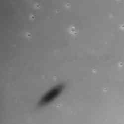
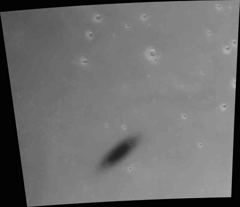
Black and white view of Phobos’s shadow. Image credit: ESA Click to enlarge
This image, taken by the High Resolution Stereo Camera (HRSC) on board ESA’s Mars Express spacecraft, shows the fast-moving shadow of the moon Phobos as it moved across the Martian surface.

The HRSC obtained this unique image during orbit 2345 on 10 November 2005. These observations would not have been possible without the close co-operation between the camera team at the Institute of Planetary Research at DLR and the ESA teams, in particular the mission engineers at ESA’s European Space Operations Centre (ESOC) in Darmstadt, Germany.

They confirm the model of the moon’s orbit around Mars, as it was determined earlier in 2004 also on the basis of HRSC images. They also show that with accurate planning even moving objects can be captured exactly at their predicted position.

The basis for such observations is the accurate knowledge of the spacecraft position in its orbit as well as of the targeted location on Mars to within a few hundred metres.

Phobos is the larger of the two Martian moons, 27 kilometres by 22 kilometres in size, and travels around Mars in an almost circular orbit at an altitude of about 6000 kilometres. Phobos takes slightly more than 7.5 hours to complete a full revolution around the planet.

When it is between the Sun and Mars, Phobos casts a small and diffuse shadow onto the Martian surface. To an observer on Mars, this would appear as a very quick eclipse of the Sun. This is similar to an eclipse on Earth, when the Moon covers the solar disk but much slower.

The shadow of Phobos has an elliptical shape on the Martian surface, because the shadow’s cone hits the surface at an oblique angle. This shadow appears to be distorted even more because of the imaging technique of the HRSC.

The shadow moves across the surface with a speed of roughly 7200 kilometres per hour from west to east. The spacecraft travels with a higher speed of about 12 600 kilometres per hour on its almost polar orbit from south to north.

Since HRSC scans the surface synchronised with the flight velocity of Mars Express, it takes some time to cover the shadow in its full dimension. Within this short time, however, the moon moves on, and therefore the shape of its shadow is ‘smeared’ in the HRSC image.

Another phenomenon, that the shadow is darker at its centre than the edges, can be explained by again imagining the observer on Mars. With its small size, Phobos would only cover some 20% of the solar disk.

Even if the observer stood in the centre of the shadow, they would still be illuminated by the uncovered part of the Sun’s disk, in a partial solar eclipse instead of a total eclipse.

Members of the HRSC Science Team recalculated the orbit of Phobos on the basis of images taken in 2004. With the help of the improved orbit determination ? the moon has advanced about 12 kilometres with respect to its previously predicted position along its orbit ? it was possible to calculate those precise times when the shadow observations could be made. In turn, it was possible to verify the accuracy of the improved orbit determination by the shadow’s position in the new images.

Original Source: ESA Portal

Tethys and Titan

The two moons Titan and Tethys with its great crater Odysseus. Image credit: NASA/JPL/SSI Click to enlarge
Cassini looks toward Tethys and its great crater Odysseus, while at the same time capturing veiled Titan in the distance (at left).

Titan (5,150 kilometers, or 3,200 miles across) is shrouded in a thick, smog-like atmosphere in which many small, potential impactors burn up before hitting the moon’s surface. Crater-pocked Tethys (1,071 kilometers, or 665 miles across) has no such protective layer, although even a thick blanket of atmosphere would have done little good against the impactor that created Odysseus.

The eastern limb of Tethys is overexposed in this view.

The image was taken in visible light with the Cassini spacecraft narrow-angle camera on Jan. 6, 2006, at a distance of approximately 4 million kilometers (2.5 million miles) from Titan and 2.7 million kilometers (1.7 million miles) from Tethys. The image scale is 25 kilometers (16 miles) per pixel on Titan and 16 kilometers (10 miles) per pixel on Tethys.

The Cassini-Huygens mission is a cooperative project of NASA, the European Space Agency and the Italian Space Agency. The Jet Propulsion Laboratory, a division of the California Institute of Technology in Pasadena, manages the mission for NASA’s Science Mission Directorate, Washington, D.C. The Cassini orbiter and its two onboard cameras were designed, developed and assembled at JPL. The imaging operations center is based at the Space Science Institute in Boulder, Colo.

For more information about the Cassini-Huygens mission visit http://saturn.jpl.nasa.gov . The Cassini imaging team homepage is at http://ciclops.org .

Original Source: NASA/JPL/SSI News Release

Mars Express Finds Auroras on Mars

An artist’s illustration of aurorae on night-side of Mars. Image credit: M. Holmstrom (IRF) Click to enlarge
ESA’s Mars Express spacecraft has seen more evidence that aurorae occur over the night side of Mars, especially over areas of the surface where variations in the magnetic properties of the crust have been detected.

Observations from the ASPERA instrument on board ESA’s Mars Express spacecraft show structures (inverted-V features) of accelerated electrons and ions above the night side of Mars that are almost identical to those that occur above aurorae on Earth.

Aurorae are spectacular displays often seen at the highest latitudes on Earth. On our planet, as well as on the giant planets Jupiter, Saturn, Uranus and Neptune, they occur at the foot of the planetary magnetic field lines near the poles, and are produced by charged particles ? electrons, protons or ions ? precipitating along these lines.

“Aurorae are created when energetic charged particles collide with the upper atmosphere,” says Rickard Lundin, Principal Investigator for ASPERA, from the Swedish Institute of Space Physics Physics (IRF), Kiruna, Sweden.

“When they are decelerated, energy is released that causes emissions of light – aurorae. During strong aurorae the precipitating particles are accelerated and gain energy, leading to more intense light,” said Lundin.

The scientists have found that the energy flux of the precipitating particles is large enough that it would lead to aurorae comparable to those of weak or medium intensity at Earth.

“Mars lacks a strong intrinsic magnetic or dipole field, and therefore we have not had reason to believe that aurorae occur there,” said Lundin.

A few years ago it was suggested that auroral phenomena could exist on Mars too. This hypothesis was reinforced by the Mars Global Surveyor discovery of ‘crustal magnetic anomalies’, most likely the remnants of an old planetary magnetic field.

This discovery started speculation that auroras could also occur at Mars. In 2004, the SPICAM instrument on board Mars Express observed emissions of light during a magnetic anomalies investigation – emissions that could be due to precipitating energetic particles.

The ASPERA scientists have now found that the structures of accelerated particles are indeed associated with the ‘crustal magnetic anomalies’ at Mars, but that strong acceleration mainly occurs in a region close to local midnight.

The precise emissions of light that occur remain to be studied since the composition of the upper atmosphere on the night side is not well known. On the basis of atmospheric models, the scientists speculate that the classical ‘green’ emission line of oxygen might be present.

“But, as we see Mars as always sunlit, the aurorae on the night side of Mars cannot be observed from Earth,” added Lundin.

Original Source: ESA Portal

Venus Express Tests its Engine

Venus Express main engine firing in space. Image credit: ESA Click to enlarge
One hundred days after beginning its cruise to Venus, ESA’s Venus Express spacecraft successfully tested its main engine for the first time in space.

The main engine test is a critical step in the mission. In fact, it is due to its powerful thrust that Venus Express will be able to ‘brake’ on arrival at Venus. The spacecraft must slow down in order to be captured in orbit around the planet.

The engine was fired during the night of 16/17 February, starting at 01:27 CET (00:27 UT) and the ‘burn’ lasted for about three seconds. Thanks to this engine burn, the spacecraft changed its velocity by almost three metres per second.

About one hour later, the data received from the spacecraft by the Venus Express ground control team (via ESA’s New Norcia antenna in Australia) revealed that the test was successful.

The engine performed as expected. The spacecraft reacted correctly to the push and was able to recover the control of its attitude and to correctly point its high-gain antenna back to Earth to communicate with ground control.

All data recorded during the burn will now be carefully analysed by Astrium (who built the spacecraft) and ESA’s engineers to study the performance of the engine in detail.

The next big milestone is the Venus Orbit Insertion manoeuvre on 11 April 2006, which will require the main engine firing sequence to operate for about 51 minutes in the opposite direction to the spacecraft motion. This braking will allow the spacecraft to counteract the pull of the Sun and Venus, and to start orbiting the planet.

Venus Express is currently at a distance of about 47 million kilometres from Earth.

Original Source: ESA Portal

Greenland Ice Loss Doubled in the Past Decade

Helheim Glacier, located in southeast Greenland. Image credit: NASA/JPL Click to enlarge
The loss of ice from Greenland doubled between 1996 and 2005, as its glaciers flowed faster into the ocean in response to a generally warmer climate, according to a NASA/University of Kansas study.

The study will be published tomorrow in the journal Science. It concludes the changes to Greenland’s glaciers in the past decade are widespread, large and sustained over time. They are progressively affecting the entire ice sheet and increasing its contribution to global sea level rise.

Researchers Eric Rignot of NASA’s Jet Propulsion Laboratory, Pasadena, Calif., and Pannir Kanagaratnam of the University of Kansas Center for Remote Sensing of Ice Sheets, Lawrence, used data from Canadian and European satellites. They conducted a nearly comprehensive survey of Greenland glacial ice discharge rates at different times during the past 10 years.

“The Greenland ice sheet’s contribution to sea level is an issue of considerable societal and scientific importance,” Rignot said. “These findings call into question predictions of the future of Greenland in a warmer climate from computer models that do not include variations in glacier flow as a component of change. Actual changes will likely be much larger than predicted by these models.”

The evolution of Greenland’s ice sheet is being driven by several factors. These include accumulation of snow in its interior, which adds mass and lowers sea level; melting of ice along its edges, which decreases mass and raises sea level; and the flow of ice into the sea from outlet glaciers along its edges, which also decreases mass and raises sea level. This study focuses on the least well known component of change, which is glacial ice flow. Its results are combined with estimates of changes in snow accumulation and ice melt from an independent study to determine the total change in mass of the Greenland ice sheet.

Rignot said this study offers a comprehensive assessment of the role of enhanced glacier flow, whereas prior studies of this nature had significant coverage gaps. Estimates of mass loss from areas without coverage relied upon models that assumed no change in ice flow rates over time. The researchers theorized if glacier acceleration is an important factor in the evolution of the Greenland ice sheet, its contribution to sea level rise was being underestimated.

To test this theory, the scientists measured ice velocity with interferometric synthetic-aperture radar data collected by the European Space Agency’s Earth Remote Sensing Satellites 1 and 2 in 1996; the Canadian Space Agency’s Radarsat-1 in 2000 and 2005; and the European Space Agency’s Envisat Advanced Synthetic Aperture Radar in 2005. They combined the ice velocity data with ice sheet thickness data from airborne measurements made between 1997 and 2005, covering almost Greenland’s entire coast, to calculate the volumes of ice transported to the ocean by glaciers and how these volumes changed over time. The glaciers surveyed by those satellite and airborne instrument data drain a sector encompassing nearly 1.2 million square kilometers (463,000 square miles), or 75 percent of the Greenland ice sheet total area.

From 1996 to 2000, widespread glacial acceleration was found at latitudes below 66 degrees north. This acceleration extended to 70 degrees north by 2005. The researchers estimated the ice mass loss resulting from enhanced glacier flow increased from 63 cubic kilometers in 1996 to 162 cubic kilometers in 2005. Combined with the increase in ice melt and in snow accumulation over that same time period, they determined the total ice loss from the ice sheet increased from 96 cubic kilometers in 1996 to 220 cubic kilometers in 2005. To put this into perspective, a cubic kilometer is one trillion liters (approximately 264 billion gallons of water), about a quarter more than Los Angeles uses in one year.

Glacier acceleration has been the dominant mode of mass loss of the ice sheet in the last decade. From 1996 to 2000, the largest acceleration and mass loss came from southeast Greenland. From 2000 to 2005, the trend extended to include central east and west Greenland.

“In the future, as warming around Greenland progresses further north, we expect additional losses from northwest Greenland glaciers, which will then increase Greenland’s contribution to sea level rise,” Rignot said.

For information about NASA and agency programs on the Web, visit:
http://www.nasa.gov/home.

For University of Kansas Center for Remote Sensing of Ice Sheets information, visit:
http://www.cresis.ku.edu/flashindex.htm.

JPL is managed for NASA by the California Institute of Technology in Pasadena.

Original Source: NASA News Release

Book Review: Europa, the Ocean Moon

The moon Europa orbits the giant gas planet Jupiter. The recent Galileo probe and the more dated Voyager probe traveled past this moon and, with their collection of sensors, they took measurements. Galileo, even with its failed main communication antenna, was kept busy taking pictures. Some images filled in the blanks remaining from Voyager. Others were high resolution views of noteworthy features. Other sensors already revealed that a water-ice layer lies overtop an earthen core. However, there are almost no craters. So the surface is relatively new. No one knows how the surface refreshes itself but one option is for local heat from the ground to melt the overburden of ice. Of course, water, heat and some other choice ingredients are the ingredients for life. This possibility is what gives Europa its present allure.

Europa is front and centre throughout this book and in it Greenberg pushes a number of related agendas. First and foremost he classifies aspects of the images and associates them to possible causes. There is no expectation for the viewer to be a wiz as Greenberg starts slow and builds up. A history lesson begins the book. Galileo’s personal observations start the ball rolling, then Greenberg continues on with eccentricity, rotation, tides and stresses. The detail can get nitty-gritty, but not to such a depth as to loose the general reader. Suffice it to say that he’s very thorough with his description of the likely forces at play on Europa’s surface.

Having completed this background, Greenberg goes on to describe each of the classifications he and his team made from the images. Using the complete set transmitted by the Galileo probe, he presents, in a clear and thorough fashion; exotic ridges, bounding cycloids, complex chaos areas and spotty lentiuclae. But he doesn’t just leave the descriptions standing on their own. For each he provides an hypothesis for their formation and often he supports these with results from computer simulation. Further, ready references to nearby black and white or colour images allow the reader to also view the special shapes. Greenberg’s explanations are clear, succinct and well supported.

Another agenda that Greenberg raises in this book regards the politics of scientific exploration. Though Greenberg is part of the Galileo Imaging Team, he bemoans its seemingly military structure over his preferred equal weighted collective. His concern is that science might become subject to personal issues. As such, there are many references to Greenberg or a member of his team being harangued by the status quo who were supporting their own canonical model. Because of this, an interesting undertone of uncertainty exists throughout the book as well as perhaps a tinge of animosity. Yet, these don’t distract from the science and do add a certain human perspective to the writing.

A final agenda or objective is an apparent desire to capture and store hard won knowledge. The perception is that the research funding is running out and the team members are disbanding. Hence, for posterity’s sake, the results of many years’ and many peoples’ work are brought together between two covers.

Though relying upon little technical information, Greenberg has written an exemplary book. Chapters stand well on their own and each leads smoothly into the next. The sum total defines a comprehensive hypothesis regarding the shaping of Europa’s surface. Sub-theories have a sound basis and each have an excellent description. A plethora of images allow the reader to appreciate the team’s challenges and their hard won results. Because of this, the book is a solid, self-contained overview of Europa that would be a great reference for a researcher or an interesting read for anyone wanting to check-out what’s happening at one of the leading edges of planetary science.

Being at the forefront of science is exhilarating on its own. Sharing the wonders with other people increases the satisfaction even more. Richard Greenberg’s Europa, The Ocean Moon summarizes his research and that of his colleagues resulting from the Galileo probe’s mission to Jupiter. Europa’s ice surface may seem haphazard in construct but with intuition and perception, we can see how science can make reason out of this exotic world.

Review by Mark Mortimer

Read more reviews online or purchase a copy from Amazon.com

Three Moons in a Row

Dione, Prometheus and Epimetheus all aligned in a row. Click to enlarge
This fortunate view sights along Saturn’s ringplane to capture three moons aligned in a row: Dione (1,126 kilometers, or 700 miles across) at left, Prometheus (102 kilometers, or 63 miles across) at center and Epimetheus (116 kilometers, or 72 miles across) at right.

The image was taken in visible light with the Cassini spacecraft narrow-angle camera on Jan. 2, 2006, at a distance of approximately 2.8 million kilometers (1.7 million miles) from Saturn. The image scale is 19 kilometers (12 miles) per pixel on Dione, and about 17 kilometers (11 miles) per pixel on Prometheus and Epimetheus.

The Cassini-Huygens mission is a cooperative project of NASA, the European Space Agency and the Italian Space Agency. The Jet Propulsion Laboratory, a division of the California Institute of Technology in Pasadena, manages the mission for NASA’s Science Mission Directorate, Washington, D.C. The Cassini orbiter and its two onboard cameras were designed, developed and assembled at JPL. The imaging operations center is based at the Space Science Institute in Boulder, Colo.

For more information about the Cassini-Huygens mission visit http://saturn.jpl.nasa.gov . The Cassini imaging team homepage is at http://ciclops.org .

Original Source: NASA/JPL/SSI News Release

Japan’s New Satellite Sends Back its First Image

An image of Mt. Fuji, the first image acquired by ALOS. Image credit: JAXA Click to enlarge
This image of Mt. Fuji is the first data to be acquired by Japan’s recently launched Advanced Land Observing Satellite (ALOS) on 24 January 2006. ESA is supporting ALOS as a ‘Third Party Mission’, which means the Agency will utilise its multi-mission ground systems of existing national and industrial facilities and expertise to acquire, process and distribute data from the satellite to users.

Mt. Fuji ? Japan?s highest mountain (3 776 metres) ? is a volcano that has been dormant since its last eruption in 1707. It is located near the Pacific coast and straddles the prefectures of Yamanashi and Shizuoka about 100 kilometres west of Tokyo.

Detailed streets and rivers in the Kofu Basin are visible in the front of the image, and Motosu Lake, one of five lakes making up the Fuji Five Lake region, is in the centre right. The Fuji-Subaru road, which leads to the top of the mountain from Motosu Lake, can also be seen.

Motosu Lake, featured on the 5000 Yen note, is the westernmost of the five lakes, all of which were formed by lava flows, and has a circumference of 13 kilometres. The other four lakes are: Kawaguchi Lake, Yamanaka Lake , Sai Lake and Shoji Lake.

Thousands of people ascend Mt. Fuji every year, usually during July and August (the official climbing season) when there is no snow. The mountain hike is divided into ten stations, with paved roads going to the fifth station (around 1400 to 2400 metres above sea level).

The image data was acquired as part of the initial functional verification test since the satellite’s launch. One of ALOS’ three onboard instruments, the Panchromatic Remote-sensing Instrument for Stereo Mapping (PRISM), observed the mountain at 02:00 CET (10:30 Japan time) on 14 February 2006.

The PRISM is an optical sensor which has three independent optical systems for acquiring terrain and altitude data simultaneously, allowing for three-dimensional images with a high accuracy and frequency.

The other two instruments onboard ALOS are the Phased Array type L-band Synthetic Aperture Radar (PALSAR), a microwave radar instrument that can acquire observations through any weather conditions, and the Advanced Visible and Near Infrared Radiometer type-2 (AVNIR-2), designed to chart land cover and vegetation in visible and near-infrared spectral bands.

Original Source: ESA Portal

Surgery in Space

Surgery in space might be not that far away. Image credit: NASA Click to enlarge
If scientists can put a man on the moon, or send him into space for a few years at time, can they enable astronauts to perform complex surgical procedures there, too?

Professor Adam Dubrowksi of surgery doesn’t see why not, and he’s making space surgery a focus of his research. There’ll be a need for it once astronauts in the International Space Station begin to stay on board for extended periods, says Dubrowski, who is also a kinesiologist in the Surgical Skills Centre at Mount Sinai Hospital. The U.S. National Aeronautics and Space Administration (NASA) and the Canadian Space Agency (CSA) are also looking towards a mission to Mars, a journey that will take three to four years each way.

“The longer you stay, the more potential there is for things to happen,” Dubrowski points out, noting that lacerations and trauma injuries are certainly possible. Currently, astronauts get a few hours of medical training on the ground, which is insufficient for treating more serious injuries, he says. Although typically a medical doctor is on board the space station, “everybody has to know a bit of everything.” On longer missions, he anticipates having a physician and a highly skilled medical assistant who are both trained in surgery, while the rest of the crew will be trained in the basics.

Currently, emergencies are dealt with on board the space station and surgery can be performed using a remote-controlled robot. But as spaceships get further away from Earth, robotic surgery is no longer possible because the signals take longer to reach the mission, Dubrowski explains. And “no one understands what happens when you’re in zero gravity” and need to suture or staple a wounded person.

So Dubrowski, his wife, Waterloo kinesiology professor Heather Carnahan, and Dr. Gary Gray, a Canadian Space Agency consultant from Defence Research and Development Canada, hope to explore these questions with CSA funding. The three have already conducted zero-gravity research into basic motor skills such as touching one’s nose or tying one’s shoes. A weightless environment affects a person’s hand-eye co-ordination, aim and ability to apply a certain amount of force when undertaking tasks, he says. Dubrowski’s interest in space research began after he received his PhD in kinesiology in 2001 from the University of Waterloo. A native of Poland who immigrated to the Toronto area, Dubrowski was influenced by a visit to Dr. Otmar Bock, a leading German researcher in zero-gravity, following completion of his doctoral studies. The two maintained a collaboration, which helped Dubrowski get funding from the European Space Agency and the German Space Agency.

Now, the Canadian Space Agency plans to develop a surgery training protocol for astronauts and Dubrowski, Carnahan and Gray ? with the support of the experts from the Surgical Skills Centre and the Wilson Centre ? plan to bid for the contract. At the same time, they will be applying for smaller funds for parabolic flight research.

Space-surgery training will be three-pronged, Dubrowski explains. The first step is adaptation to zero gravity using an inverted paradigm in which experimental participants are placed upside down on something similar to a bed to “get more of an idea of weightlessness.”

The second step will be simulating zero gravity in a swimming pool; Dubrowski and Surgical Skills Centre manager Lisa Satterthwaite are working on procuring something similar to the huge swimming pool with the replica of the space station used in the NASA centre in Houston. “You can adjust the buoyancy of the person so they’re suspended in water,” Dubrowski says. “That’s another way of simulating zero gravity.”

Third, trainees will take their basic surgery skills on parabolic flights in which an airplane ascends and descends roughly 40 times, creating a transient zero-gravity environment on the descents. Dubrowski uses a variety of simple and complex simulators to allow students at the Surgical Skills Centre to practise skills such as stitching with skin patches.

Surgery in space isn’t that far away, Dubrowksi predicts; there are plans to put a manned lunar base on the moon in the next five to 10 years, which will necessitate better surgical skills for the longer missions. And the sooner the better, he says.

Original Source: U of T News Release

Ski Jumping on the Moon

“Go big or go home.” That’s what aerialists on the US Olympic ski team say, and when they say “big,” they mean it.

Big means “Big Air,” 20 meters above the ground, as high as a five-story building. Aerial skiers fly into the void as fast as a motorcycle speeds down a city street, flipping head over heels, twisting and flipping again. The sky tumbles, but dizziness is not allowed, because only 3 heart-pumping seconds after launch, it’s time to land.

“And you don’t want to land on your ? well ? you know,” says aerial skier and Olympic gold medalist Eric Bergoust: educational video.

He should know. In the sport of aerial skiing, Bergoust has done it all. He was one of the first skiers ever to complete a quad-twist triple flip–four twists and three flips in mid-air. In 1998, hours after a frightening crash in practice, he used the move to win gold at the Nagano Olympic Games. At the time, his score was the highest ever recorded. This year, he’s a top contender again in Torino.

Bergoust has a knack for invention. He has designed new skis to soften the impact of practice landings in swimming pools. He has altered the shape of ski jumps, called “kickers,” to make flights longer-lasting and safer. And his take-off method, raising one arm propeller-style to add twist to his flight, is widely imitated.

His next innovation: “We should jump on the moon! There’s plenty of fresh powder (moondust),” he explains. “And I figure the 1/6 g would give us a lot of hang time.” More hang time means more flips–and more gold.

Consider the following:

On Earth, a typical run begins with Bergoust hurtling down a 23-degree slope. By the time he reaches bottom, 20 meters below the starting gate, he’s traveling almost 70 km/hr?directly into the kicker. From a skier’s point of view, the kicker looks uncomfortably like a wall, but it’s really a ramp guiding the aerialist almost straight up in the air. Bergoust’s favorite kickers are angled at 70 degrees! Up he goes, hanging for nearly 3 seconds before landing in soft snow another 20+ meters beyond the ramp.

see captionNow imagine the same run?same hill, same kicker, same skier?on the moon. Because lunar gravity is less, Bergoust would accelerate downslope at a more gradual pace, reaching bottom with a speed of only 28 km/hr. On Earth, such a slow start would be a disaster. On the moon, it’s perfect. Leaving the kicker at that speed, Bergoust hangs in the “air” for a whopping seven seconds, more than twice his hang-time on Earth: proof.

“I might be able to double my quad-triple,” he says.

Remember, Bergoust won gold in 1998 with a quad-triple. Since then other skiers have added a single twist to his move, turning it into a quint-triple. “Quints” are expected to win the men’s freestyle aerials in Torino. On the moon, Bergoust would have time to add four more twists and three more flips to his routine. “Let’s see?” calculates Bergoust, “that would be an octuple-twist sextuple flip.” Guaranteed gold.

Now for the problems:

skiing on the moonMoondust, although it is powdery, is not as slippery as snow. On the contrary, moondust is very abrasive. It is made of tiny sharp fragments of glass and rock produced by eons of meteoroids pulverizing the moon. Compared to snow, moondust is a “slow surface,” maybe too slow for a good jump.

To combat this, skiers are going to need extra-slick skis coated with Teflon or some other low-friction material. Thin films of diamond might be the answer. Diamond-like carbon films in Earth laboratories rival Teflon in slipperiness, with the advantage of diamond-like hardness to resist the scratching action of sharp-edged dust.

Another problem is the kicker. On Earth, kickers are made of snow. Workers blow snow into large wooden forms laid out at the base of the slope. A spray of water helps the snow stick together and makes the ramp slippery-smooth. Disassemble the forms and?voila!?a kicker.

Imagine the same process on the moon. Workers assemble their form and begin dumping moondust into it. There’s no water hose to squirt the dust to make it stick together. Water exposed to lunar vacuum sublimates (vaporizes) in a flash. So the dust remains dry. Disassemble the forms and?voila!?the kicker slumps into a shapeless pile.

The solution in this case might be a microwave water hose. In labs on Earth, researchers have discovered that grains of moondust cooked in a microwave oven quickly melt and stick together. Spraying moondust with microwaves might allow Olympic workers to mold a good kicker.

And finally?the landing.

On Earth, aerial skiers land on a layer of soft snow, which cushions their impact. On the moon, they’ll land on a layer of soft moondust. Very likely, the dust will spray upwards, coating the skier’s suit.

What’s the problem? Ask any Apollo astronaut. They hated it when moondust got on their spacesuits. Dark dust absorbed sunlight, causing the suit to overheat. Sharp edges of the dust cut into seals, springing leaks. Dust-covered visors were hard to see through. A skier’s suit, thoroughly “dusted,” might be useless after a single run. Another problem to solve….

Bergoust loves solving problems. For years he’s been tinkering with skis, redesigning kickers, inventing new moves, and he’s ready for a new frontier.

“I just need to find a spacesuit!”

Original Source: NASA News Release