Book Review: Heavenly Intrigue

Tycho Brahe was a Danish nobleman who spent his life taking the most exact measurements of stars and planets then known. Being of high ranked noble birth, his family’s expectations were for Brahe to enter into court politics. Yet Brahe followed his own path, that being his love for astronomy. Even his slight divergence into alchemy quickly returned to astronomy on seeing the skies brighten from a supernova. Nevertheless, this being Europe of the early 1600’s, politics dominated lives. Brahe was exiled when a new king sat upon the Danish throne and he ended up in Prague as the mathematician of the court of the Holy Roman Empire.

At almost the same time, Johannes Kepler was using his intellect to escape his difficult and lowly lifestyle. Earning passage into a university, he excelled at mathematics and also fell into a love of astronomy and astrology. Kepler equally had difficulties in life and though he married a lady who had extensive land holdings, all their wealth disappeared. The politics of the time was again the culprit. Fortuitously, Kepler had already connected with Tycho Brahe who had given him an invitation to work and live together. Kepler, apparently without any other options, accepted. Much later, after Brahe’s death, Kepler used Brahe’s data to determine his now well known three laws of planetary motion.

Most references, in discussing Brahe and Kepler, provide little more information than the above. The Gilders, however, have gone digging. With the help of many experts and original documents, they build the characters of these scientists. Brahe may have been a nobleman, but he seems to have continually turned his back to the corresponding lifestyle. Kepler was not only smart with numbers but also had a tendency to quickly lose friends through a hot temper. Many details of their lives get reviewed; their parents, their places of birth, their schooling and their relationships. Yet this is not a simple biography of these two individuals. This is a case of murder. For the authors show that Kepler, with his temper and his craving for fame, wanted and needed Brahe’s data to pursue his own postulations about the shape of the heavens.

The key element in the Gilder’s book comes from recent investigations. Brahe’s crypt was recently repaired and, given this opportunity, some hairs were analyzed to try to deduce the cause of his death. The authors use tools of today’s forensic experts to understand a bit of what was happening with Brahe during his final days. In so doing, they combine these results with many pieces of circumstantial evidence to substantiate their belief that Kepler had the opportunity, means and motive. This case is a bit cold, actually more than 400 years old, but the Gilders make it fresh and exciting by reliving the times of these scientists and making the two much more than footnotes in a physics text.

This ability to enliven a well aged event sets this book apart. Very little science graces its pages. Some description of Brahe’s observatories and sextants show the state of the art in astronomical observation. A little on Kepler’s Mysterium Cosmographicum give an idea of the philosophical issues of the times. For the most part, the Gilders dish up a finely flavoured selection of the pertinent points and issues that embellish their belief of a dastardly deed. A delicious undertone questions the drive of scientists and society. That is, just how far outside society’s mores do we allow researchers when the result adds knowledge or ability for all. The answer to this question might have changed in 400 years, but it is still relevant to ask today.

People come in all stripes and colours. Brilliant scientists might be lousy friends. Fantastic leaders might be so inept with numbers as to be unable to balance their own finances. This potpourri of characteristics bring spice to our lives. However, some spices are not as well liked as others. The murder that Joshua Gilder and Anne-Lee Gilder so boldly proclaim in their book Heavenly Intrigue is one such. Perhaps a golden opportunity brought together Johannes Kepler and Tycho Brahe, but read this book and see how other opportunities may have prematurely ended their association.

Review by Mark Mortimer

Read more reviews online, or purchase a copy from Amazon.com.

New Details About Space Shuttle Successor

Artist illustration of the new Crew Exploration Vehicle. Image credit: Northrop Grumman. Click to enlarge.
A Northrop Grumman-Boeing team has unveiled its plans to design and build NASA’s proposed Crew Exploration Vehicle, a successor to the space shuttle that will carry humans to the International Space Station by 2012 and back to the moon by 2018. Shown in these artist concepts, the new, modular space vehicle comprises a crew module reminiscent of the Apollo spacecraft, a service module and a launch-abort system.

A Northrop Grumman-Boeing team has unveiled its plans to design and build NASA’s proposed Crew Exploration Vehicle, a successor to the space shuttle that will carry humans to the International Space Station by 2012 and back to the moon by 2018. Shown in these artist concepts, the new, modular space vehicle comprises a crew module reminiscent of the Apollo spacecraft, a service module and a launch-abort system.

The CEV comprises a crew module that builds on NASA’s Apollo spacecraft, a service module and a launch-abort system. It is designed to be carried into space aboard a shuttle-derived launch vehicle — a rocket based on the solid rocket booster technology that powers the early phases of current shuttle flights.

The CEV will be produced both as a crewed space transportation system and as an uncrewed space vehicle capable of transporting cargo to and from the International Space Station. NASA expects to select a CEV prime contractor in the spring of 2006.

According to Doug Young, program manager for the Northrop Grumman-Boeing CEV team, the team’s design approach to the CEV and the overall mission architecture have been evolving over the past year.

“We’ve been working closely with NASA to identify design options and technologies that would enable the nation to meet its space exploration goals of safety, affordability and reliability,” Young said. “Early on we concluded that this modular, capsule-based approach would establish an ideal foundation for a successful, sustainable human and robotic space exploration program. It’s also a system that can be designed and built today using proven technologies, which will help maintain the nation’s leadership role in human space flight.”

While similar in shape to the Apollo spacecraft that carried astronauts to the moon in the late ’60s and early ’70s, the new CEV is a quantum leap forward in terms of performance, reliability and on-orbit mission capability.

“The CEV we plan to build will benefit not so much from a single, technical breakthrough but rather from evolutionary improvements in structural technologies, electronics, avionics, thermal-management systems, software and integrated system- health-management systems over the past 40 years,” said Leonard Nicholson, the Northrop Grumman-Boeing team’s deputy program manager.

According to Nicholson, the CEV offers many fundamental improvements over Apollo. Among them:

– CEV’s crew module will have much more internal volume than the Apollo capsule, but will only be slightly heavier, due to the use of advanced structural materials and technologies that reduce the size, weight and power consumption of key subsystems.

– CEV’s crew module will carry up to six astronauts, while Apollo carried just three.

– CEV will carry more fuel for lunar return than Apollo, allowing it to change its orbit rather than relying on the moon and the Earth to be in the right relative positions.

– CEV will be able to operate as an autonomous spacecraft orbiting the moon for up to six months while its crew of four descends to the lunar surface in the lunar lander. Crew members and ground controllers will be able to communicate with the CEV and monitor its “vital signs” remotely. During the Apollo era, one astronaut stayed with the “mother ship” while the lunar lander carrying two astronauts descended to the moon.

– CEV will use two fault-tolerant subsystems and integrated system-health- management systems to allow it to detect, isolate and recover from subsystem failures. By comparison, Apollo generally had only single fault tolerance.

A unit of The Boeing Company, Boeing Integrated Defense Systems is one of the world’s largest space and defense businesses. Headquartered in St. Louis, Boeing Integrated Defense Systems is a $30.5 billion business. It provides network-centric system solutions to its global military, government and commercial customers. It is a leading provider of intelligence, surveillance and reconnaissance systems; the world’s largest military aircraft manufacturer; the world’s largest satellite manufacturer and a leading provider of space-based communications; the primary systems integrator for U.S. missile defense; NASA’s largest contractor; and a global leader in sustainment solutions and launch services.

Northrop Grumman Corporation is a global defense company headquartered in Los Angeles, Calif. It provides technologically advanced, innovative products, services and solutions in systems integration, defense electronics, information technology, advanced aircraft, shipbuilding and space technology. With more than 125,000 employees, and operations in all 50 states and 25 countries, the company serves U.S. and international military, government and commercial customers. Today, more than 20,000 of Northrop Grumman’s employees are devoted to space-related projects.

Original Source: Northrop Grumman News Release

Second Chinese Shenzhou Launches

China continued on its ambitious plans for human space exploration this morning with the launch of its second manned spacecraft this morning. The capsule Shenzhou-6 was lofted into orbit atop a Chinese Long March booster, carrying two astronauts: Fei Junlong and Nie Haisheng. The mission is expected to last up to 5 days, and the astronauts will perform a series of scientific experiments.

What’s Up This Week – October 10 – October 16, 2005

Voyager photo of Neptune. Image credit: NASA/JPL. Click to enlarge.
Monday, October 10 – Today in 1846, William Lassell was busy at his scope as he made a new discovery – Neptune’s moon Triton! Although our everyday equipment can’t “see” Triton, we can still have a look at Neptune in central Capricornus. At near magnitude 8, Neptune will appear as no more than a near stellar-sized, slightly blue-tinged disc. You’ll find it just slightly less than a fingerwidth to the northeast of Theta Capricornii. While you might think finding Neptune is a bit disappointing visually, consider this… We’re able to see it 4.3 billion kilometers away! Not bad considering we’re on a planet that would fit inside its dark oval.

Tonight on the lunar surface, let’s return again to a favourite old feature. In the lunar north, you cannot help but see the long, deep scar of the Alpine Valley slashing its way across the lunar Alps. Power up and see if you can spot tiny crater Trouvelot on its eastern edge. Now let’s head north across Mare Frigoris for more! Perhaps you’ll spy Rimae Archytas near the terminator along the mare’s southern shore. As you head north across the smooth sands, look for the larger punctuations of Protogoras and Archytas on the northern shore. If you continue north, the ruined crater W. Bond will meet your eye, with its small eastern crater and crater Timaeus with its central peak caught on W. Bond’s southern wall.

Tuesday, October 11 – Tonight the lunar terminator will have moved to reveal another old familiar crater to the north – Plato. Let us use it as our guidepost and see what we can find!

To the casual eye, the interior of Plato would appear to be smooth, but if conditions are steady? Power up to the max. Inside you will find as many as five small craterlets. Along its outside western wall, look for a deep impact crater – A. Carefully note there is a long depression, perhaps caused by a glancing meteor strike, that angles off to the northwest from its northern wall crest that ends in a small crater! To the northeast, you might find a thin rimae, like a crack, that traces its way towards the beginning of the Montes Alpes. Head north again across Mare Frigoris and you will see the remains of crater Birmingham and Epigenes between it and last night’s W. Bond. Look further north for the shallow Goldschmidt with the younger Anaxagoras intruding upon its west wall. And, of all the craters to the very north? What better name to give one than Byrd – for the American polar explorer!

Wednesday, October 12 – Today in 1892, astronomy great E. E. Barnard was hard at work. Using photography, he became the first to discover a comet -1892 V – in this way.

With lunacy, our best shot is a morning comet that you’d almost need a camera for – C/2003 K4 LINEAR scooting across Eridanus. While this is not an easy comet – large telescopes only – at roughly magnitude 12.5, we’d like to thank SkyHound for this excellent chart. Good luck!

Tonight on the Moon, let’s take an in-depth look at one of the most impressive of the southern lunar features – Clavius.

Although you cannot help but be drawn visually to this crater, let’s start at the southern limb near the terminator and work our way up. Your first sighting will be the large and shallow dual rings of Castatus with its central crater and Klaproth adjoning it. Further north is Blancanus with its series of very small interior craters, but wait until you see Clavius. Caught on the southeast wall is Rutherford with its central peak and crater Porter on the northeast wall. Look between them for the deep depression labeled D. West of D you will also see three outstanding impacts C, N and J, while CB resides between D and Porter. The southern and southwest wall are also home to many impacts and look carefully at the floor for many, many more! It has been often known as a test of a telescope’s resolving power to see just how many more craters you can find inside tremendous old Clavius. Power up and enjoy!

Thursday, October 13 – Today marks the founding of the British Interplanetary Society in 1933. “From imagination to reality”, the BIS is the world’s longest established organization devoted solely to supporting and promoting the exploration of space and astronautics.

Tonight we’ll do them proud as we have a look at newly revealed crater, Longomontanus.

Northwest of last night’s study – Clavius – Longmontanus is also a crater with many wonderful details. As you power up to observe, note that it has obliterated a much older crater whose remains can be seen just outside its east wall. Inside Longomontanus, you’ll see a very small collection of central peaks and a terrific series of smaller impacts on its northwest wall. Now let’s concentrate outside Longomontanus’ north wall as we identify the remains of Montanari with an impact on the ruins of its west wall. Due east is the double strike of crater Brown. As we continue north, we see crater Wilhelm with its multiple strikes between its south wall and Montanari’s north. Look for a series of four small impacts which separate it and Heinsus to the north.

Friday, October 14 – Tonight the Moon’s peaceful crater Gassendi will call, but we’re about to set sail on the “Ocean of Storms” as we visit the southern section of Oceanus Procellarum.

Let’s leave from the port of Gassendi and head north to small crater Gassendi B. As you move out onto the grey sands, look for a serene wave which follows the southwestern shoreline. Its name is Dorsa Ewing and you will see it trail south into the pockmark of Herigonius almost due east of Gassendi B. To its east you will see two additional craters, and the northernmost is Norman. Return again to Dorsa Ewing and trace it north where it leads into some low hills and the tiny crater Scheele and far more prominent Wichmann further north. If you look closely a Wichmann you will see it is a small impact on what looks to be the remains of a long flooded, and terribly eroded crater. Ride the waves in the “Ocean of Storms” and see to what ports it takes you!

Saturday, October 15 – Today in 1963 marks the first detection of an interstellar molecule. This discovery was made by a group headed by Sander Weinreb using the MIT Millstone Hill 84-foot dish. Using new correllation receiver technology, hydroxyl molecules were found as absorption bands using the supernova remnant Cas A as a background continuum source. By the dawn of the new millenia, nearly 200 different interstellar molecules had been identified and many of these are considered organic in nature.

Tonight let’s see what might be up there in the region of Cas A using visible light shall we? The nearest bright star to Cas A is magnitude 2.4 Caph (Beta Cas) – the brightest and most westward of the stars making up the Cassiopeia “W”. To locate the region of Cas A, sweep about 6 degrees due west of Caph and follow the subtle curve of three 5th magnitude stars. Cas A lies less than one degree south-southwest of the second star in the sequence of three. That star is a complex 4.9 magnitude multiple star system associated with variable star AR Cas.

Through binoculars two stars of this system are easily resolved – the 4.9 magnitude primary led across the sky by a 7.1 magnitude secondary. The 76 arc second distant secondary (component C) is actually a very tight double itself having a 1.4 arc second separated 8.9 magnitude partner which should be resolvable in fine 4 inch instruments. The very finest, large-apertured amateur scopes may also be able to distinguish a 9.3 magnitude 0.9 second B-component from the 4.9 magnitude primary. Smaller scopes are back in the running again when attempting three 11th magnitude stars – none of which are closer than 42 arc seconds to the primary. Intermediate apertured scopes can also hope to pick out a 12.9 magnitude H component 27 arc seconds northwest of the 7.1 magnitude C component. 8.9 magnitude F also has a 9.1 magnitude near twin 11 arc seconds east-northeast. If you can see them all you should probably wrap an observatory building around your telescope – if one isn’t there already!

If you like to follow brightness changes in variables – AR Cas is not a good choice. This eclipsing type variable only fluctuates by a tenth of a magnitude over a period 6 earth days!

When we are finished, let us go from one extreme to another as we begin on the northernmost limb of the lunar surface. From the northernmost portion of Sinus Roris, look for the lens-shaped crater Markov. To the northeast you will spy a large, flat looking crater with very little distinguishing characteristics whose name is Oenpides. If conditions are very stable, you might stand a chance at a grey slash on the very lunar edge further north known as Cleostratus. On the southern end we see familiar craters Wargentin, Nasmyth and Phoclides, but go to the very southern limb – the long oval is named Pingre.

Sunday, October 16 – Tonight after the Sun sets, let’s take a look at where Venus is now! Using binoculars, you’re in for a real treat as you will notice that Antares is also in the same field of view. Now look again unaided. This bright pair are only separated by about 1.5 degrees. Watch again tomorrow night as they move further apart.

Tonight the great Grimaldi will capture the eye, but head southeast for another featureless dark grey oval, Crueger. The next crater south is hard to see, because it really doesn’t appear like a crater. Its name is Darwin, and it is “evolved” to the point where it is best caught by focusing on its rimae which includes its east wall. Look for a Y formation pointing towards Crueger.

Before you think I’m finished with you, I’m going to ask western American observers to get up early. Why? Because there will be a partial lunar eclipse tomorrow morning! The Earth’s shadow will just nick the edge of the Moon and only around 7% will go dark. While this is just a minor event, I’d get up early to watch and perhaps you will, too! You’ll find much more information on this event here on NASA’s pages. Wishing you clear skies!

Until next week? Ask for the Moon, but keep reaching for the stars! May all your journeys be at light speed…. ~Tammy Plotner

Cryosat Launch Fails

Cryosat launch. It crashed back to Earth shortly after. Image credit: ESA. Click to enlarge.
Mr Yuri Bakhvalov, First Deputy Director General of the Khrunichev Space Centre on behalf of the Russian State Commission officially confirmed that the launch of CryoSat ended in a failure due to an anomaly in the launch sequence and expressed his regret to ESA and all partners involved.

Preliminary analysis of the telemetry data indicates that the first stage performed nominally. The second stage performed nominally until main engine cut-off was to occur. Due to a missing command from the onboard flight control system the main engine continued to operate until depletion of the remaining fuel.

As a consequence, the separation of the second stage from upper stage did not occur. Thus, the combined stack of the two stages and the CryoSat satellite fell into the nominal drop zone north of Greenland close to the North Pole into high seas with no consequences to populated areas.

An investigating commission by the Russian State authorities has been established to further analyze the reasons for the failure, results are expected within the next weeks. This commission will work in close cooperation with a failure investigation board consisting of Eurockot, ESA and Khrunichev representatives.

This information is released at the same time by Eurockot and ESA.

Original Source: ESA News Release

Gravity Probe B Wraps Up Observations

Artist illustration of the Gravity Probe B satellite in orbit. Image credit: NASA/Stanford. Click to enlarge.
Almost 90 years after Albert Einstein first postulated his general theory of relativity, scientists have finished collecting data to put it to a new, different kind of experimental test.

NASA’s Gravity Probe B satellite has been orbiting the Earth for more than 17 months. It used four ultra-precise gyroscopes to generate the data required for this unprecedented test. Fifty weeks worth of data has been downloaded from the spacecraft and relayed to computers in the Mission Operations Center at Stanford University, Stanford, Calif. Scientists have begun the painstaking task of data analysis and validation, which is expected to take approximately one year.

“This has been a tremendous mission for all of us,” said Francis Everitt, Gravity Probe B principal investigator at Stanford. “With all the data gathered, we are proceeding deliberately to ensure everything is checked and re-checked. NASA and Stanford can be proud of what has been achieved so far.”

Launched on April 20, 2004, from Vandenberg Air Force Base, Calif., Gravity Probe B has been using four spherical gyroscopes to precisely measure two extraordinary effects predicted by Einstein’s theory. One is the geodetic effect, the amount by which the Earth warps the local space time in which it resides. The other, called frame-dragging, is the amount by which the rotating Earth drags local space time around with it.

“The completion of the GP-B mission is the culmination of years of hard work, training and preparation by the GP-B team,” said Tony Lyons, NASA GP-B program manager from NASA?s Marshall Space Flight Center in Huntsville, Ala.

“We are proud to have been associated with this extremely significant mission,” said Bob Schultz, Lockheed Martin’s Gravity Probe B program manager. “Working with Stanford and NASA, we formed a powerful team to develop the challenging technologies needed to take a giant step forward in helping understand Einstein’s theory of general relativity.”

The Marshall manages the Gravity Probe B program. Stanford conceived the experiment and is NASA’s prime contractor for the mission. Stanford was responsible for the design and integration of the science instruments and mission operations. The university has the lead for data analysis. Lockheed Martin Space Systems Company designed, integrated and tested the space vehicle and built some major payload components.

Original Source: NASA News Release

Early Earth Had Toxic Oceans

Rock formation in northern Australia. Image credit: Jochen J. Brocks. Click to enlarge.
NASA exobiology researchers confirmed Earth’s oceans were once rich in sulfides that would prevent advanced life forms, such as fish and mammals, from thriving. The research was funded in part by NASA’s exobiology program.

A team of scientists from the Massachusetts Institute of Technology and Harvard University, working with colleagues from Australia and the United Kingdom, analyzed the fossilized remains of photosynthetic pigments preserved in 1.6 billion-year-old rocks from the McArthur Basin in Northern Australia.

They found evidence of photosynthetic bacteria that require sulfides and sunlight to live. Known as purple and green sulfur bacteria because of their respective pigment colorations, these single-celled microbes can only live in environments where they simultaneously have access to sulfides and sunlight.

The researchers also found very low amounts of the fossilized remains of algae and oxygen-producing cyanobacteria. The relative scarcity of these organisms is due to poisoning by large amounts of sulfide.

“This work suggests Earth’s oceans may have been hostile to animal and plant life until relatively recently,” said Dr. Carl Pilcher, NASA’s senior scientist for astrobiology. “If so, this would have profound implications for the evolution of modern life.”

“The discovery of the fossilized pigments of purple sulfur bacteria is totally new and unexpected. Because they need fairly high intensity sunlight, it means the pink bacteria, along with their essential source of sulfide, close to the surface, perhaps as close as 20 to 40 meters,” said Roger Summons, Massachusetts Institute of Technology professor of geobiology. “The sulfide would have come from bacteria that reduces sulfate carried into the oceans by the weathering of rocks.”

“The McArthur Basin rocks were deposited over a very large area and over many millions of years, so it’s likely they formed under water that was intermittently connected to or actually part of an ocean. In turn, this implies the ocean had an abundant and continuous supply of hydrogen sulfide and must have been quite toxic to any oxygen-breathing organisms,” said team member Jochen Brocks. “In fact, for seven-eighths of Earth’s 4.5 billion-year history, there was probably little oxygen in the oceans and certainly not enough to support oxygen-breathing marine animals.”

This research continued the efforts of NASA and partner institutions to understand the early history of the Earth. Research results were published in the Oct. 6, 2005, edition of Nature magazine.

The research was conducted by a team working in Summons’ laboratory. Team members include Jochen Brocks, formerly of Harvard and now at Australian National University; Gordon Love, Massachusetts Institute of Technology; Stephen Bowden, University of Aberdeen, Scotland; Graham Logan, Geoscience Australia; and Andrew Knoll, Harvard.

Original Source: NASA News Release

ESA’s CryoSat is Ready for Launch

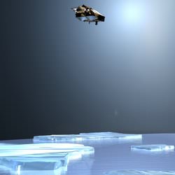
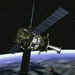
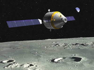
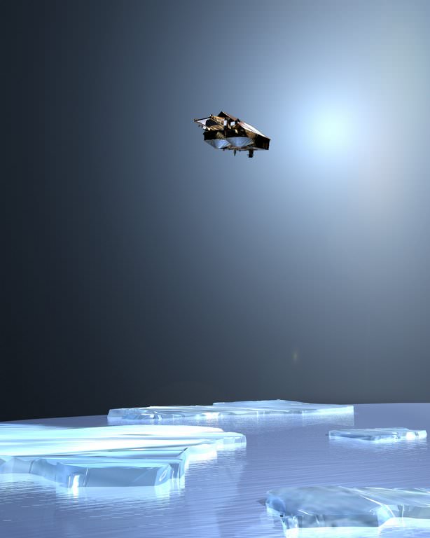
Artist’s illustration of Cryosat. Image credit: ESA. Click to enlarge.
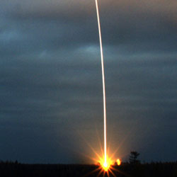
The expectations of ice researchers across Europe are currently focused on a region of taiga woodland in Russia’s far north. Located in a forest clearing is Pad LC133 of Plesetsk Cosmodrome, where above the tree-line on a Rockot launcher stands ESA’s CryoSat satellite, due to start its flight into orbit this Saturday at 17:02 CEST.

The first of ESA’s Earth Explorer series – missions tailored to respond to particular needs of the Earth science community – CryoSat will use a specialised radar altimeter to measure changes in land and sea ice thickness over a three-year period, to provide a precise picture of how the Polar Regions are responding to climate change.

The generation of radar altimeters currently flying on satellites including ERS-2 and Envisat have made a large contribution to our knowledge of the mass balance of Greenland and Antarctic ice sheets, but they cannot return reliable data from the ice edge, where the rate of change is greatest. Similarly, over the ocean their resolution is insufficient to detect the majority of individual pack ice pieces. The design of CryoSat’s new SAR Interferometric Radar Altimeter (SIRAL) has been optimised to close these data gaps.

Many European ice specialists have played a part in the preparation for the mission, either through participation in the CryoSat Science Advisory Group, taking part in extensive in-situ calibration and validation activities in the Arctic and Antarctic, or preparing processing algorithms to turn raw altimetry results into usable information products. And whether or not they have made such direct contributions, researchers are eagerly awaiting the unique results CryoSat will return.

“Summer Arctic sea ice is shrinking ? but is it thinning?”
Dr Seymour Laxon of the Centre for Polar Modelling (CPOM) at University College London has been part of the mission with the start ? working closely with Lead Investigator Professor Duncan Wingham from the original mission proposal to ESA onwards.

“At that time we had just managed to extract the first plausible sea ice thickness maps from the radar altimeter on ESA’s ERS,” Dr. Laxon remembers. “Coupled with Duncan’s experience in mapping the ice sheets, ESA’s Earth Explorer Opportunity programme seemed like a great chance for us to build on what we had learned from the earlier ESA missions to design a mission that was really focused on altimetry over ice.”

A period of concentrated effort followed, as findings from past exploratory studies, and the latest results from ERS, were converted into a proposal for a new mission that could better those results.

“I vividly remember the selection procedure, with Duncan reporting back at each selection stage that CryoSat was still in the running,” Dr. Laxon adds. “I don’t think either of us were quite ready to hear the news that CryoSat was the first to be selected.

“At that point we both realised that the real work, to build a complete mission scenario from scratch, had started. Now everything is in place, the satellite sitting on top of its launcher, the processing system for the data, and plans for the post-launch validation campaign. Now we are just looking forward to seeing the very first data.”

In terms of his own area of interest, it is the sea ice data that Dr. Laxon is most looking forward to: “The most exciting thing for me is the prospect of seeing the first maps of sea ice thickness from CryoSat. We have not seen estimates of Arctic sea ice thickness around the North Pole since the last submarine data from 1999 were declassified.”

“Back then, analysis of this data suggested that a significant ? up to 40% – thinning had occurred since the 1960s, with the largest thinning around the pole. The big question is whether that thinning has reversed or continued as we have entered the new century.”

“That question has gained even more impetus since the news that the extent of summer ice in the Arctic has reached a record minimum this year. But has it also thinned? That’s the crucial question to which CryoSat will provide the answer.”

Opening a new window on the Poles
Professor Chris Rapley is Director of the Cambridge-based British Antarctic Survey and is also Chair of the Planning Group for the forthcoming International Polar Year, which will take place in 2007-8, during the time CryoSat will be carrying out its ice thickness survey. He has had a long involvement with radar altimetry over ice.

Prof. Rapley states: “I was deeply involved in the preparations for the ESA ERS and Envisat altimeters, and led or contributed to a substantial series of studies commissioned by ESA to explore the use of satellite radar altimeters over polar land ice and sea ice, and the technical advances required in instruments, data processing and analysis software to achieve useful scientific results.”

That activity included work on designing and implementing the UK-based ERS processing and archiving facility and the ESA altimeter data processing chain and associated software. Prof. Rapley also worked on design studies for more advanced altimeters along CryoSat’s lines.

A past member of ESA’s Earth Observation Advisory Committee (ESAC), Prof. Rapley was also involved in reviewing the CryoSat proposal and its adoption as an ESA Earth Explorer.

“What I am looking forward to is the best measure yet of the Antarctic and Greenland ice sheet mass balance,” Prof. Rapley adds. “CryoSat should also open a new window on the nature, geographic distribution and the seasonal/systematic behaviour of Antarctic and Arctic sea ice.”

“We can add ice thickness to our models”
Direct in-situ observations of land and sea ice have been necessary to establish that the CryoSat sensor will indeed ‘see’ as anticipated, and quantify residual geophysical uncertainties. As a member of ESA’s CryoSat Cal/Val Team, Dr. Christian Haas of the Alfred Wegener Institute in Bremerhaven coordinates German activities in this area.

“I lead the German CryoSat office,” says Dr. Haas. “It is the main interface between German users and scientists involved in Cryosat and ESA. We are also raising money in Germany for work with CryoSat.

“I am also coordinating the sea ice validation work in the Arctic and Antarctic. We at the Alfred Wegener Institute are the only group able to measure sea ice thickness directly, by helicopter-borne electromagnetic measurements with our EM-bird sensor. We have conducted the CryoVex (CryoSat Validation Exercise) campaign in 2003 and this year’s Bay of Bothnia campaign.”

As a geophysicist, Dr. Haas has been working with sophisticated software models of sea ice. Results from CryoSat will be used to first to check these models, then later be directly ingested within them to bring them closer to reality. The satellite’s ice thickness data in particular should literally add a new dimension to their representation of polar sea ice.

“As a scientist I am interested in using CryoSat data for validating our sea ice models, and combining the data with other met-ocean data to better understand the variability of sea ice thickness,” Haas explains. “We also want to assimilate sea ice thickness into our models.”

After CryoSat’s launch comes a further validation campaign, to compare the results from space to the reality on ground, as Haas adds: “I am looking forward to the validation of the satellite, and the opportunity of extending our airborne measurements laterally by means of the satellite.

Is Antarctic land ice growing or shrinking?
Other researchers, such as Dr. Massimo Frezzotti of Italy’s National Agency for New Technologies, Energy and the Environment (ENEA) in Rome hope to use the new satellite’s results to improve their knowledge of ice sheets on land.

Dr. Frezzotti has carried out in-situ studies of the Antarctic ice sheet between the Italian base of Terra Nova Bay on the shores of the Ross Sea and the new Franco-Italian Concordia base high on the Antarctic Plateau some 1200 kilometres inland. He also makes use of altimetry results in his research.

“I already use ERS altimeter data to study the influence of wind erosion on surface mass balance,” Dr. Frezzotti explains. “Previous altimeters are not able to provide a detailed model of the coastal areas, which are a very crucial area for mass balance studies. CryoSat will partially cover this gap.”

Satellite altimetry observations over the ocean have established a steady rise in global sea level of an average 0.3 millimetres a year. What is not known ? yet ? is how changes in polar ice thickness may be contributing to this trend.

“The Antarctic ice sheet contains sufficient ice to raise worldwide sea level by more than 60 metres if melted completely,” Dr. Frezzotti adds. “The amount of snow deposited annually on its surface is equivalent to five or six millimetres of global sea level. Thus the ice sheet could be a major source of water for the present-day rise in sea level, but the uncertainty is still large.

“Despite all available measurements of snow accumulation, ice velocity, surface and basal melting and iceberg discharge, it is still not known for certain even whether the ice sheet is growing or shrinking.” CryoSat should remedy this state of affairs.

Determining CryoSat’s orbit will improve its results
The Department of Earth Observation and Space Systems (DEOS) of the Delft University of Technology has an interest in the precise orbit determination (POD) of radar altimeter satellites. Because altimetry is based on the principle that time equals distance ? measuring how long it takes for a radar pulse to travel back from the Earth’s surface to the spacecraft – more exact knowledge of the satellite’s location at any one time greatly improves the quality and accuracy of the final data.

CryoSat has two onboard instruments for sharpening orbital estimates from a matter of metres down to a maximum three centimetres ? the Doppler Orbitography and Radiopositioning Integrated by Satellite (DORIS) radio receiver and a Laser Retro-reflector (LRR). Both these devices are found on a number of different satellites, and work based on global networks of radio transmitters and laser stations.

In addition a satellite trajectory prediction model will be created by DEOS to forecast how CryoSat’s orbit will be perturbed by the slight pressure of sunlight and the drag of the upper atmosphere as well as gravitational tugs from terrestrial gravity field anomalies as well as the influence of the tides, other planets and our Sun.

“We will determine CryoSat’s orbit, but in addition we will also perform cal/val activities for its SIRAL instrument, particularly in the Low-Rate Mode (LRM) over the open ocean and inland ice sheets,” said Dr. Ernst Schrama. “Comparing LRM sea surface results to in-situ buoys and tidal gauges should enable a means of externally validating LRM results.?

“We will also add CryoSat data to our Radar Altimeter Database System (RADS) compiled from other current as well as past altimeter missions. The database will be used to inter-compare the performance of SIRAL against other altimeters.”

Beyond improving the quality of CryoSat results, RADS also represents a scientific resource in its own right, which provides a continuous set of sea level measurements of constant quality. RADS can be used for scientific and operational oceanography as well as detecting slight variations in the Earth’s gravity field to infer its interior structure.

Original Source: ESA News Release

Large Craters on Dione

Large craters across the surface of Dione. Image credit: NASA/JPL/SSI. Click to enlarge.
When naming features on other worlds, scientists like to follow themes, and Dione is no exception. Dione possesses numerous features with names from Virgil’s “Aeneid.” The prominent crater showing a central peak below the center is Dido, a 118-kilometer-wide (73-mile) crater named after the supposed founder of Carthage. The crater just above Dido is Antenor, an 82-kilometer-wide (51-mile) impact crater named after the nephew of Priam who founded the Italian city of Padua. At the upper right is the 97-kilometer-wide (60-mile) impact crater Turnus, which lies at the western end of Carthage Linea, a region of bright, fractured terrain. Dione is 1,118 kilometers (695 miles) across.

The sunlit terrain seen here shows some of the wispy markings on the moon’s trailing hemisphere. Cassini revealed that these markings are actually a complex system of fractures.

North on Dione is up and rotated 25 degrees to the left.

The image was taken in visible light with the Cassini spacecraft narrow-angle camera on Aug. 25, 2005, at a distance of approximately 1.1 million kilometers (700,000 miles) from Dione and at a Sun-Dione-spacecraft, or phase, angle of 107 degrees. Resolution in the original image was 7 kilometers (4 miles) per pixel. The image has been magnified by a factor of two and contrast-enhanced to aid visibility.

The Cassini-Huygens mission is a cooperative project of NASA, the European Space Agency and the Italian Space Agency. The Jet Propulsion Laboratory, a division of the California Institute of Technology in Pasadena, manages the mission for NASA’s Science Mission Directorate, Washington, D.C. The Cassini orbiter and its two onboard cameras were designed, developed and assembled at JPL. The imaging operations center is based at the Space Science Institute in Boulder, Colo.

For more information about the Cassini-Huygens mission visit http://saturn.jpl.nasa.gov . The Cassini imaging team homepage is at http://ciclops.org .

Original Source: NASA/JPL/SSI News Release