Hurricane Wilma Becomes a Record Setting Cat 5

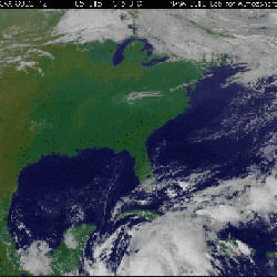
Satellite view of Hurricane Wilma. Image credit: NASA/NOAA. Click to enlarge.
In the early morning hours of Wednesday, October 19 in the warm Caribbean waters, Hurricane Wilma strengthened from a Category 2 hurricane to the most intense Hurricane 5 hurricane on record.

Hurricanes are measured by factors such as atmospheric pressure, winds and storm surge. Wilma’s atmospheric pressure at 8 a.m. EDT measured 882 millibars. The previous record was 888 millibars set in 1988 by Hurricane Gilbert that moved through the Gulf of Mexico.

At 8 a.m. Wednesday, October 19, Wilma was packing maximum sustained winds of 175 mph (280 km/hr) with higher gusts. Wilma’s center was located near latitude 17.2 north and longitude 82.8 west or about 340 miles (550 km) southeast of Cozumel, Mexico. Wilma is moving toward the west-northwest near 8 mph (13 km/hr). A turn toward the northwest is expected during the next 24 hours.

According to the National Hurricane Center, Wilma is a potentially catastrophic Category 5 hurricane on the Saffir-Simpson scale. Fluctuations in intensity are common in hurricanes this intense and are likely during the next 24 hours.

Wilma is a smaller storm than Katrina. Wilma’s hurricane force winds extend outward to 15 miles (30 km) from the center and tropical storm force winds extend outward up to 160 miles (260 km).

Based on data from dropsondes, instruments that are dropped into the storm from Hurricane Hunter planes that fly over it, and flight-level data from an Air Force plane, Wilma’s minimum central pressure is estimated to be 882 millibars (26.05 inches). This is the lowest pressure on record for a hurricane in the Atlantic basin.

Rainfall by Wilma is expected to be high. Wilma is expected to produce storm total accumulations of 10 to 15 inches with local amounts near 25 inches in mountainous terrain across Cuba through Friday. Additional rainfall accumulations of 5 to 10 inches, with local amounts of 15 inches, are possible across the Cayman Islands, Swan Island and Jamaica through Thursday.

From Honduras northward to the Yucatan peninsula of Mexico through Thursday, storm total accumulations of 4 to 6 inches, with isolated amounts of 8 to 12 inches are possible.

Watches and warnings have been posted throughout the region. A hurricane watch is in effect for the east coast of the Yucatan Peninsula from Cabo Catoche to Punta Gruesa. A hurricane watch is also in effect for Cuba in the provinces of Matanzas westward through Pinar del Rio and for the Isle of Youth. A hurricane watch means that hurricane conditions are possible within the watch area, generally within 36 hours.

Tropical storm warnings are up for Honduras from the Honduras/Nicaragua border westward to Cabo Camaron. A tropical storm warning and a hurricane watch remain in effect for the Cayman Islands.

Current forecast models project Wilma making landfall in southwest Florida on Saturday, Oct. 22 or Sunday, Oct. 23. All residents in the Florida Keys and the Florida peninsula should closely monitor the progress of extremely dangerous Hurricane Wilma. Story credit: Rob Gutro, NASA

Original Source: NASA News Release

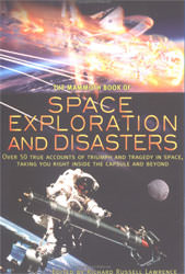
Book Review: Mammoth Book of Space Exploration Disasters

Humans and high speed vehicles have been getting together for a long time. The need for added speed keeps us experimenting. From two horse chariots to four horse, or galleons to schooners, we keep finding ways of getting ourselves moving faster and further. Rocket power swiftly followed the advent of planes, giving us freedom from the grip of land. Then ballistic missiles sent us past the slight friction of our atmosphere and into the near complete emptiness of space. With every advent of new technology and speed, there were flaws and errors. A chariot wheel fractures and dumps the drivers onto the ground. This may lead to no more than a bruised ego. But, when a thin ring of rubber fails on a rocket, the results are much more disastrous. Sad as this may be, one of humanity’s common traits is a greater interest in failures than successes. Hence, though we have made many successful flights into space, it is the failures that interest most people, even a long time after the event and it is this trait that gets treated with this book.

To satisfy this interest, Richard Lawrence has compiled a collection of stories, narrations and articles. These cover the time from planes using rockets in 1953 to the launch of the Rosetta mission in 2004. There is Neville Duke an early air speed record holder who describes rocket flight. Chuck Yeager powers through a description of his first transition through the sound barrier. Buzz Aldrin depicts Apollo 11’s landing, while Lovell repaints his sojourn in Apollo 13. As well, Lawrence with Bryan Burrough, provide their own rendition of the time a Progress supply vessel crashes into the Mir space station. These and others in the collection bring back to life many of the most memorable crises of humans and rocketry.

In addition to the events themselves, the styles of the presentations show the maturation of the technology. The early stories usually refer to only one person who was fully integrated with the craft and often referred to it as an extension of themselves. Later narrations, in particular the very dry excerpts from the commission’s report on the Challenger and Columbia accidents, show the remote controlled nature of flight even to the associated communications. Exceptions do occur though as Jerry Linenger eloquently echos his feelings of almost uncontrollable terror while dangling in the void of space at the end of a boom extending from the Mir station.

In editing, Richard Lawrence chose an excellent collection of narrations covering humans and rocketry. By selecting first hand accounts, or very well placed second hand accounts, he continually places the reader directly at the event. He provides clarification by adding a few paragraphs before each selection to aid the reader in understanding the situation. Though these articles represent a quite superficial and somewhat negative view of humanity’s progress with rocketry, as indicated by the sensationalist title, still many youths might be pleasantly swayed by much of the emotional delivery. That is except for the very dry and bureaucratic style of the selections for the Challenger and Columbia accidents. Certainly there are other thoughtful, technically accurate and strongly emotional narrations for these.

For many good and bad reasons, people contentedly place themselves into perilous situations. Perhaps this is the nature of humanity, to offer your singular service for the greater good. In the book edited by Richard Russell Lawrence entitled Space Exploration and Disasters, there are many stories of people striving to do their best against some astounding challenges. And, as often seen, people were able to adapt, apply innovative thinking and respond successfully.

Review by Mark Mortimer

Read more reviews online, or purchase a copy from Amazon.com.

Future Space Missions Will Explore at Many Levels

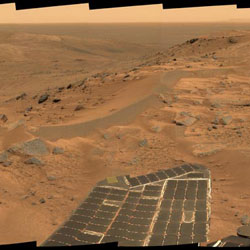
Spirit’s view of Mars. Image credit: NASA/JPL. Click to enlarge.
Remote-sensing orbiters, probes, landers and rovers are returning astonishing discoveries about our solar system. But some of the most exciting geological and potentially astrobiological places in our family of planets and moons are dangerous and difficult to explore.

University of Arizona, California Institute of Technology, and U.S. Geological Survey Flagstaff researchers propose a novel space mission concept for finding and exploring the most scientifically important surfaces and subsurfaces throughout the solar system.

These next-generation robotic missions will simultaneously explore distant locales at several levels – from orbit, from the air and on the ground – to home in on important geology, hydrology, climate and possibly astrobiology in distant worlds, said James M. Dohm of The University of Arizona. Dohm, a planetary geologist in UA’s department of hydrology and water resources, has mapped Mars at local to global scales. He is involved with autonomous long-range roving, sensor web and orbiting spacecraft experiments.

Wolfgang Fink, a visiting associate at Caltech, Dohm and others discuss the new mission concept in an article, “Next-generation robotic planetary reconnaissance missions: A paradigm shift,” to be published in Elsevier?s journal of Planetary and Space Science (http://www.elsevier.com/, go to Article in Press link). They spearheaded a team effort that includes Mark Tarbell, who is Fink’s associate in Caltech’s Visual and Autonomous Exploration Systems Research Lab; Trent Hare of the U.S. Geological Survey office in Flagstaff; and Victor Baker, Regents’ Professor of the UA departments of hydrology and water resources, planetary sciences and geosciences.

The new mission concept would feature orbiting spacecraft, blimps and balloons at planets or moons with sufficient atmospheres, such as Titan, and numerous simple, deployable mobile and immobile ground sensors. These spaceborne, airborne, and ground agents would be programmed to look smartly at the environment and interact with each other, offering a true “tier-scalable” perspective needed for a science-driven mission, Dohm said.

“We are now at an optimal window in time when spacecraft and airborne units can coordinate with ground-based sensors, especially since much of the technology is already available,” said Fink, a physicist and an expert in imaging systems, autonomous control and space mission science analysis systems. “Even technology not currently available — software, primarily — is quite attainable.”

?It’s important to look at layers and layers of evidence, not just one type,” Dohm said.

For example, Fink said, a rover with feature-recognition software can look for a unique rock that could contain a critical piece of the history of Mars. “If you add an airborne perspective, you also see what?s on the other side of the hill at the same time, and you know the rover’s exact field location as well,” he said. The orbiter has the global picture of what’s going on and commands the airborne and ground tiers below it.

The orbiter in a tier-scalable mission is equipped with current information about the surface, atmosphere and other features of its destination. Its sensor suite might include optical and thermal cameras, spectrometers, and ground-penetrating radar. These instruments would collect information on areas that the orbiter’s software recognizes as possible interesting targets given the overall mission science goals.

“The orbiter can deploy the airborne agents for a closer look,” Fink said. “The orbiter also can command the airborne agents to safely deploy ground agents to the prime targets. The airborne agents help detect and confirm prime targets.”

“The ground agents can measure information such as heat or moisture,” Dohm said. “Or they can sample or collect diverse rocks and, in the case of Mars, possible near-surface water. There could be numerous lightweight, expendable sensors, so that even if you lost a few, you’d still have mission.”

The sensors send information back to their respective airborne probes, and ultimately to the orbiting spacecraft. Based on this new information, the orbiter sends new commands that drive the mission.

“The spaceborne, airborne, and ground agents all work together as a field geologist,” Dohm said. “They analyze information to form a working hypothesis.” They would be ideal for exploring Valles Marineris, the expansive canyon system of Mars, or Europa’s putative ice-covered ocean, he added.

In the case of Valles Marineris, for instance, Dohm said, the orbiting spacecraft would deploy sensors that would transmit weather conditions back to the spacecraft. If the sensors give the spacecraft a good weather report – no high winds, for example – the spacecraft would then release the balloons or blimps. These airborne agents would start their searches for targets important to mission goals, collecting and adding new information as they go and deploying ground agents at promising candidate sites. The ground agents would collect and return data to the higher-level airborne probes, or the orbiter, or both. “If the goal at Valles Marineris was to find possible water seeps or near-surface water, a drill rig might even be deployed at the most promising site,” Dohm said.

Fink and Dohm say the new concept needs further design, testing and ground-truthing in diverse Earth environments. They envision field camps for international researchers for designing and testing possible tier-scalable reconnaissance systems.

Intelligent, science-driven robotic space missions are a decade or two in the future, they will be international, and they will have significant corporate and private sponsorship, Dohm and Fink predict.

Original Source: University of Arizona News Release

Cassini’s Closeup View of Dione

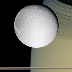
Dione perched in front of Saturn. Image credit: NASA/JPL/SSI. Click to enlarge.
Sitting in the tranquility of space is the pale moon Dione, looking as if it’s posing for a painter. The moon is set against the stunning backdrop of Saturn, adorned in gold and draped with hues of blue.

Breathtaking views and a movie of the icy world are now available at http://saturn.jpl.nasa.gov and http://www.nasa.gov/cassini .

During the Cassini spacecraft’s only close flyby of the grayish moon, on Oct. 11, 2005, the spacecraft came within 500 kilometers (310 miles) of the surface.

Like most of its counterparts in the Saturnian system, Dione shows a heavily cratered surface. It has a signature style all its own that includes streaky terrains dominating one whole side of the moon. The fine latitudinal streaks appear to crosscut everything and appear to be the youngest feature type in this region of Dione. These striking cracks and fractures are caused by tectonic activity.

“Dione seems to be an older sibling of Enceladus,” said Dr. Bonnie Buratti, scientist on the Cassini visual and infrared mapping spectrometer team at NASA’s Jet Propulsion Laboratory, Pasadena, Calif. “We think that the cracked features of Dione may be the older version of the tiger stripes on Enceladus. Enceladus is the up-and-coming moon, complete with a recently active history, while Dione is the older, more mature moon.”

The Cassini infrared spectrometer team is working on compositional maps of the moon’s surface.

As it departed its encounter with Saturn?bfs moon Dione, Cassini sailed above an unreal landscape blasted by impacts. The rising Sun throws craters into sharp contrast and reveals steep crater walls.
Multiple generations of fractures are visible on Dione. Numerous fine, roughly parallel grooves run across the terrain and are interrupted by the larger, irregular, bright fractures. In several places, fractures postdate some deposits in the bottoms of craters.

The Cassini ultraviolet imaging spectrograph team reports the detection of water ice on the surface of Dione and also finds striking brightness variations across the surface. This could be the result of cracks and fractures in the ice. “The ice in the fractures appears to be different than in the surrounding terrain. This may be due to the grain size variations,” said Dr. Amanda Hendrix, Cassini scientist at JPL.

As on other Saturnian moons, rockslides on Dione may reveal cleaner ice, while the darker materials accumulate in areas of lower topography, such as crater floors and the bases of scarps.

Scientists on the Cassini fields and particles instruments note that early results do not support the presence of an atmosphere. Dione orbits Saturn within the broad, tenuous E-ring. Hence, scientists will be looking to see if Dione, like Enceladus, is a source of material in the E-ring. They also seek to learn whether the E-ring is affecting Dione’s surface. Over the coming months, scientists will begin to piece together a more detailed story of Dione.

Following the rendezvous with Dione, Cassini captured its best views ever of the tiny moon Telesto. “Telesto was too small in Voyager images to see detail on the surface. Cassini has given us the best views of the potato-shaped chunk of ice,” said Dr. Candice Hansen, Cassini scientist at JPL. Early results indicate the entire moon, roughly 24 kilometers across (15 miles), is ice.

Next up for Cassini, on Oct. 28, is a close pass of Titan, Saturn’s largest moon. During this pass Cassini’s powerful radar will be pointed to image the Huygens probe landing site and surrounding terrain.

Original Source: NASA/JPL/SSI News Release

What’s Up This Week – October 17 – October 23, 2005

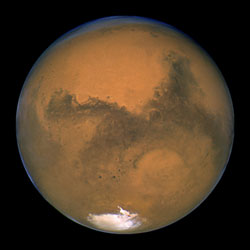
Mars. Image credit: NASA/JPL
Monday, October 17 – Did readers on the West Coast get a chance to see the partial lunar eclipse this morning? Excellent, because the Full Hunter’s Moon will make “hunting” most deep sky objects next to impossible tonight. But who cares when you can see Mars in such great detail!

Is it really that good and really that worth the wait for it to rise? The answer is yes. Even through a small telescope it is very easy to see the dark markings and the brilliant polar cap. Although Mars won’t rise for good viewing until late evening, don’t wait any longer to start your observations. In larger telescopes at higher powers, you will see Mars as you have never seen it before. Even if you do not use a telescope, you cannot miss this huge, bright, reddish planetary disc rising in the east.

Want a map? Care to sketch? Or would you just like more details? Then you’ll find no site more comprehensive than the Association of Lunar and Planetary Observers. This ALPO page contains everything you’ll need to tun this year’s “Mars Experience” into the best you’ve ever had!

Tuesday, October 18 – Today in 1959, Soviet Luna 3 began returning the first photographs of the Moon’s far side. Also today – but in 1967 – the Soviets again made history as Venera 4 became the first spacecraft to probe Venus’ atmosphere. Unlike Mars, Venus shows little details but it’s still a fine way to start the evening. Look for its bright, phasic disc just west of Sagittarius after sunset.

If you’d really like to see some details, try looking at the lunar surface tonight and focus your attention towards the stretched oval of crater Gauss located about midway on the northern quadrant of the eastern limb. With the terminator so near, can you see four southern interior craters? Move further south and central on the limb. Mare Smythii might be gone, but look at small, overlapping craters Jenkins and Nobili.

Wednesday, October 19 – For viewers in Spain, Portugal, Italy and Greece, you have a very rare and exciting event this morning! Asteroid Rhodope will eclipse bright star – Regulus. While this event requires no special equipment, your observances could make a significant contribution to the folks at the International Occultation and Timing Association (IOTA). Please take the time to visit this page for details on how you can help scientific studies. An event like this won’t happen again until 2014… Please watch. Wishing you clear skies!

For viewers in the United States and Canada, tonight is a definitely celestial gathering as the Moon, Mars and the Pleiades will make a wonderfully tight trio as the come up in the east, and this would be a great night to explore!

While we’re waiting on them to rise, let’s have a look in Cassiopeia at two of its primary stars.
Looking much like a flattened “W” the southern-most bright star is Alpha. Also known as Schedar, this magnitude 2.2 spectral type K star, was once suspected of being a variable, but no changes have been detected in modern astronomy. Binoculars will reveal its orange/yellow coloring, but a telescope is needed to bring out its unique features. In 1781, Sir William Herschel discovered a 9th magnitude companion star and our modern optics easily separate the blue/white component’s distance of 63″. A second, even fainter companion at 38″ is mentioned in the list of double stars and even a third at 14th magnitude was spotted by S.W. Burnham in 1889. All three stars are optical companions only, but make 150 to 200 light year distant Schedar a delight to view.

Just north of Alpha is the next destination for tonight – Eta Cassiopeiae. Discovered by Sir William Herschel in August of 1779, Eta is quite possibly one of the most well-known of binary stars. The 3.5 magnitude primary star is a spectral type G, meaning it has a yellowish color much like our own Sun. It is about 10% larger than Sol and about 25% brighter. The 7.5 magnitude secondary (or B star) is very definitely a K-type, metal poor, and distinctively red. In comparison, it is half the mass of our Sun, crammed into about a quarter of its volume and around 25 times dimmer. In the eyepiece, the B star will angle off to the northwest, providing a wonderful and colorful look at one of the season’s finest.

Thursday, October 20 – Tonight is one of the busiest night skies of the year. We are now slipping into the stream of Comet Halley and into one of the finest meteor showers around, but the Moon is going to play a very major role through tonight and tomorrow morning.

For viewers in the southern part of Europe and the northern portion of Africa, you will have the chance to watch the Moon occult 27 Taurii tonight. Be sure to visit this IOTA webpage for charts and times in your location.

If you should happen to live a little more centrally in Africa, or in South America, it just gets better as the Moon will coast through the Pleiades star cluster on this date for you. Thanks to the good folks at IOTA, you can use this reference material for more specific details. Clear skies!

Friday, October 21 – Be sure to be outdoors before dawn to enjoy one of the year’s most reliable meteor showers. The offspring of Comet Halley will grace the early morning hours as they return once again as the Orionid meteor shower. This dependable shower produces an average of 10-20 meteors per hour at maximum and the best activity begins before local midnight on the 20th, and reaches its best as Orion stands high to the south at about two hours before local dawn on the 21st.

Although Comet Halley has long since departed our Solar System, the debris left from its trail still remain scattered in Earth’s orbital pattern around the Sun allowing us to predict when this meteor shower will occur. We first enter the “stream” at the beginning of October and do not leave it until the beginning of November, making your chances of “catching a falling star” even greater. These meteors are very fast, and although they are faint, it is still possible to see an occasional “fireball” that leaves a persistent trail.

Clouded out or the Moon too bright? Don’t worry. You don’t always need your eyes or perfect skies to meteor watch. By tuning an FM radio to the lowest frequency possible that does not receive a “clear signal”, you can practice radio meteor listening. An outdoor FM antenna pointed at the zenith and connected to your receiver will increase your chances, but it’s not necessary. Simply turn up the static and listen. Those hums, whistles, beeps, bongs, and occasional snatches of signals are our own radio signals being reflected off the meteor’s ion trail!

For viewers over most of Australia, be sure to keep an eye on the sky tonight as the Moon will occult bright Beta Taurii for most locales on this universal date. Be sure to check IOTA for more specific details.

Saturday, October 22 – Something very special happened today in 2136 B.C. There was a solar eclipse and for the very first time it was seen and recorded by Chinese astronomers. And probably a very good thing because royal astronomers were executed for failure to predict!

Today is also the birthday of Karl Jansky. Born in 1905, Jansky was an American physicist as well as an electrical engineer. One of his pioneer discoveries were non-Earth based radio waves at 20.5 MHz while investigating noise sources between 1931 and 1932. And, in 1975, Soviet Venera 9 was busy sending Earth the very first look and Venus’ surface.

Thanks to just a slightly later rise of the Moon, let’s return again to Cassiopeia and start first by exploring the central most bright star, Gamma. At approximately 100 light years away, Gamma is a very unusual star. Once thought to be a variable, this particular star has been known to go through some very radical changes with its temperature, spectrum, magnitude, color and even diameter. Gamma is also a visual double star, but the 11 magnitude companion is highly difficult to perceive so close (2.3″) from the primary.

Four degrees southeast of Gamma is our marker for this starhop, Phi Cassiopeiae. By aiming binoculars or telescopes at this star, it is very easy to locate an interesting open cluster, NGC 457, because they will be in the same field of view. This bright and splendid galactic cluster has received a variety of names over the years because of its uncanny resemblance to a figure. Some call it an “Angel”, others see it as the “Zuni Thunderbird”, I’ve heard it called the “Owl” and the “Dragonfly”, but perhaps my most favourite is the “E.T. Cluster”, As you view it, you can see why. Bright Phi and HD 7902 appear like “eyes” in the dark and the dozens of stars that make up the “body” appear like outstretched “arms” or “wings”. (For E.T. fans? Check out the red “heart” in the center.)

All this is very fanciful, but what is the NGC 457, really? Both Phi and HD 7902 may not be true members of the cluster. If magnitude 5 Phi were actually part of this grouping, it would have to have a distance of approximately 9300 light years, making it the most luminous star in the sky, far outshining even Rigel! To get a rough of idea of what that means, if we were to view our own Sun from this far away, it would be no more than magnitude 17.5. The fainter members of the NGC457 comprise a relatively “young” star cluster that spans about 30 light years across. Most of the stars are only about 10 million years old, yet there is 8.6 magnitude red supergiant in the center.

Sunday, October 23 – With tonight’s early dark skies, let’s take out binoculars and have a look at an old favourite – “The Double Cluster” – NGC869 and NGC884. This pair of rich galactic open clusters rising in the northeast are an unaided-eye object from a dark site, easily seen in the smallest of binoculars from urban locations and beyond compare when viewed with a telescope at lowest power.

The western-most of the pair is NGC869, also known as “h Perseii”. It contains at least 750 stars clustered in a brilliant mass spanning about 70 light years, and approximately 7,500 light years away from us. It’s eastern companion is NGC884, or “Chi Perseii”. The statistics are almost a match, but NGC884 only has about half as many stars – some being “super giants” over 50,000 times brighter than our own Sun. These twin clusters have only one major difference: NGC884 is approximately 10 million years old and the NGC869 is perhaps 5 million. The existance of these splendid clusters was cataloged as far back as 350 B.C. with both Ptolemy and Hipparchus noting their appearance – yet Messier never “discovered” them!

This issue celebrates a full year of appearing on “The Universe Today”. I thank all of you who have taken the time to write and I would love to hear your suggestions for next year. Thank you for reading! Until next week? Ask for the Moon, but keep reaching for the stars! May all your journeys be at light speed…. ~Tammy Plotner
Chinese Astronauts Return Safely to Earth

Chinese astronauts Fei Junlong and Nie Haisheng landed safely in Mongolia on Sunday, after spending 5 days in orbit. Their Shenzhou-6 capsule touched down by parachute less than a kilometre from their target, and were met by helicopters and off-road vehicles. Fei and Nie will spend the next 14 days in isolation, to observe their post flight health; however, their families will be able to visit. The Chinese Space Administration has hinted that spacewalks and women astronauts will be in future missions.

Mid-Latitude Glaciers on Mars

Viking image of Mars. Image credit: NASA/JPL. Click to enlarge.
New high-resolution images of mid-latitude Mars are revealing glacier-formed landscapes far from the Martian poles, says a leading Mars researcher.

Conspicuous trains of debris in valleys, arcs of debris on steep slopes and other features far from the polar ice caps bear striking similarities to glacial landscapes of Earth, says Brown University’s James Head III. When combined with the latest climate models and orbital calculation for Mars, the geological features make a compelling case for Mars having ongoing climate shifts that allow ice to leave the poles and accumulate at lower latitudes.

“The exciting thing is a real convergence of these things,” said Head, who will present the latest Mars climate discoveries on Sunday, 16 October, at the Annual Meeting of the Geological Society of America in Salt Lake City (specific time and location provided below).

“For decades people have been saying that deposits at mid and equatorial latitudes look like they are ice-created,” said Head. But without better images, elevation data and some way of explaining it, ice outside of Mars’ polar regions was a hard sell.

Now high-resolution images from the Mars Odyssey spacecraft’s Thermal Emission Imaging System combined with images from the Mars Global Surveyor spacecraft’s Mars Orbiter Camera and Mars Orbiter Laser Altimeter can be compared directly with glacier features in mountain and polar regions of Earth. The likenesses are hard to ignore.

For instance, consider what Head calls “lineated valley fill.” These are lines of debris on valley floors that run downhill and parallel to the valley walls, as if they mark some sort of past flow. The same sorts of lines of debris are seen in aerial images of Earth glaciers. The difference is that on Mars the water ice sublimes away (goes directly from solid ice to gas, without any liquid phase between) and leaves the debris lines intact. On Earth the lines of debris are usually washed away as a glacier melts.

The lines of debris on Mars continue down valleys and converges with other lines of debris – again, just like what’s seen on Earth where glaciers converge.

“There’s so much topography and the debris is so thick (on Mars) that it’s possible some of the ice might still be there,” said Head. The evidence for present day ice includes unusually degraded recent impact craters in these areas – just what you’d expect to see if a lot of the material ejected from the impact was ice that quickly sublimed away.

Another peculiarly glacier-like feature seen in Martian mid-latitudes are concentric arcs of debris breaking away from steep mountain alcoves – just as they do at the heads of glaciers on Earth.

As for how ice could reach Mars lower latitudes, orbital calculations indicate that Mars may slowly wobble on its spin axis far more than Earth does (the Moon minimizes Earth’s wobble). This means that as Mars’ axis tilted to the extremes – up to 60 degrees from the plane of Mars’ orbit – the Martian poles get a whole lot more sunshine in the summertime than they do now. That extra sun would likely sublime water from the polar ice caps, explains Head.

“When you do that you are mobilizing a lot of ice and redistributing it to the equator,” Head said. “The climate models are saying it’s possible.”

It’s pure chance that we happen to be exploring Mars when its axis is at a lesser, more Earth-like tilt. This has led to the false impression of Mars being a place that’s geologically and climatically dead. In fact, says Head, Mars is turning out to be a place that is constantly changing.

Original Source: Geological Society of America News Release