
Venus Express Photographs the Earth and Moon
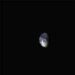
Earth and Moon system as seen by VIRTIS-M. Image credit: ESA Click to enlarge
A recent check of the VIRTIS imaging spectrometer during the Venus Express commissioning phase has allowed its first remote-sensing data to be acquired, using Earth and the Moon as a reference.
After a successful in-flight checkout of the spacecraft’s systems in the first ten days of flight, the ESOC operations team is now verifying the health and functioning of all the Venus Express instruments. These observations were made as part of this checkout.
Of course the very large distance that Venus Express has travelled since its launch makes these images of limited interest to the general public, but to the scientific team it confirms the excellent operation of their instrument.
This gives them confidence of spectacular results when the spacecraft reaches Venus where similar measurements will be made hundreds times closer.
Only two weeks after the launch, VIRTIS, the Ultraviolet/Visible/Near-Infrared mapping spectrometer, has been able to make its first planetary observations, capturing the Earth-Moon system.
“The observations were made from 3.5 million kilometres away, with a phase angle of 65 degrees, meaning that 65% of the Earth’s disk was illuminated by the Sun, providing observations of both the day and night sides of the Earth,” explains Guiseppe Piccioni, one of the two Principal Investigators (PI).
These Earth observations will be used to test the instrument on a real planetary case, before Venus approach.
“A comparison of Venus spectra with Earth spectra with the same instrument will also be of interest for textbook illustration of the comparison between the two planets,” explained Pierre Drossart, the other PI.
The Moon has also been observed, providing additional observations of particular interest for calibrating the intrument.
The VIRTIS instrument on Venus Express is a twin of the same instrument on Rosetta, and similar observations were sent back by Rosetta in March 2005, so comparisons of the two sets of observations will be very useful for calibration purposes. The VIRTIS instrument is led jointly by INAF-IASF, Rome, Italy, and Observatoire de Paris, France.
Original Source: ESA Portal
AMBER Instrument Combines Three Telescopes
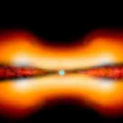
Artist’s impression of the stellar object MWC 297. Image credit: ESO Click to enlarge
Using the newly installed AMBER instrument on ESO’s Very Large Telescope Interferometer, which combines the light from two or three 8.2-m Unit Telescopes thereby amounting to observe with a telescope of 40 to 90 metres in diameter, two international teams of astronomers observed with unprecedented detail the environment of two stars. One is a young, still-forming star and the new results provide useful information on the conditions leading to the creation of planets. The other is on the contrary a star entering the latest stages of its life. The astronomers found, in both cases, evidence for a surrounding disc.
A first group of astronomers, led by Fabien Malbet from the Laboratoire d’Astrophysique de Grenoble, France, studied the young 10-solar mass stellar object MWC 297, which is still in the very early stage of its life.
“This scientific breakthrough opens the doors to an especially detailed scrutiny of the very close environment of young stars and will bring us invaluable knowledge on how planets form”, says Malbet.
It is amazing to see the amount of details the astronomers could achieve while observing an object located more than 800 light-years away and hidden by a large amount of gas and dust. They found the object to be surrounded by a proto-planetary disc extending to about the size of our Solar System, but truncated in his inner part until about half the distance between the Earth and the Sun. Moreover, the scientists found the object to be surrounded by an outflowing wind, the velocity of which increased by a factor 9, from about 70 km/s near the disc to 600 km/s in the polar regions.
“The reason why the inner part of the disc should be truncated is not clear”, adds Malbet. “This raises new questions on the physics of the environment of intermediate mass young stars.”
The astronomers now plan to perform observations with AMBER with three telescopes to measure departure from symmetry of the material around MWC 297.
Another international team of astronomers [5] has just done this kind of observations to study the surroundings of a star entering the last stages of its life. In a world premiere, they combined with AMBER the light of three 8.2-m Unit Telescopes of the VLT, gaining unsurpassed knowledge on a B[e] supergiant, a star that is more luminous than our Sun by more than a factor 10,000. This supergiant star is located ten times further away than MCW 297 at more than 8,000 light-years.
The astronomers made the observations to investigate the crucial questions concerning the origin, geometry, and physical structure of the envelope surrounding the star.
These unique observations have allowed the scientists to see structures on scale as small as 1.8 thousandths of an arcsecond – that is the same as distinguishing between the headlights of a car from about 230,000 km away, or slightly less than 2/3 of the distance from the Earth to the Moon!
Armando Domiciano de Souza, from the MPI f??bf?r Radioastronomie in Bonn (Germany) and his colleagues made also use of the MIDI instrument on the VLTI [6], using two Unit Telescopes. Using their full dataset, they found the circumstellar envelope around the supergiant to be non-spherical, most probably because the star is also surrounded by an equatorial disc made of hot dust and a strong polar wind.
“These observations are really opening the doors for a new era of understanding of these complex and intriguing objects”, says Domiciano de Souza.
“Such results could be achieved only due to the spectral resolution as well as spatial resolution that AMBER offers. There isn’t any similar instrument in the world,” concludes Fabien Malbet, who is also the AMBER Project Scientist.
Original Source: ESO News Release
Death Star Mimas and Its Giant Crater Herschel
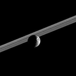
Mimas standing in front of Saturn’s rings. Image credit: NASA/JPL/SSI Click to enlarge
Impact-battered Mimas steps in front of Saturn’s rings, showing off its giant 130-kilometer (80-mile) wide crater Herschel.
The illuminated terrain seen here is on the moon’s leading hemisphere. North on Mimas is up and rotated 20 degrees to the left. Mimas is 397 kilometers (247 miles) across.
The image was taken in visible green light with the Cassini narrow-angle camera on Oct. 13, 2005 at a distance of approximately 711,000 kilometers (442,000 miles) from Mimas and at a Sun-Mimas-spacecraft, or phase, angle of 112 degrees. The image scale is 4 kilometers (3 miles) per pixel.
The Cassini-Huygens mission is a cooperative project of NASA, the European Space Agency and the Italian Space Agency. The Jet Propulsion Laboratory, a division of the California Institute of Technology in Pasadena, manages the mission for NASA’s Science Mission Directorate, Washington, D.C. The Cassini orbiter and its two onboard cameras were designed, developed and assembled at JPL. The imaging operations center is based at the Space Science Institute in Boulder, Colo.
For more information about the Cassini-Huygens mission visit http://saturn.jpl.nasa.gov . The Cassini imaging team homepage is at http://ciclops.org .
Original source: NASA/JPL/SSI News Release
Carthage Linea on Dione
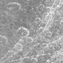
Dione’s icy surface. Image credit: NASA/JPL/SSI Click to enlarge
Dione’s icy surface is scarred by craters and sliced up by multiple generations of geologically-young bright fractures. Numerous fine, roughly-parallel linear grooves run across the terrain in the upper left corner.
Most of the craters seen here have bright walls and dark deposits of material on their floors. As on other Saturnian moons, rockslides on Dione (1,126 kilometers, or 700 miles across) may reveal cleaner ice, while the darker materials accumulate in areas of lower topography and lower slope (e.g. crater floors and the bases of scarps).
The terrain seen here is centered at 15.4 degrees north latitude, 330.3 degrees west longitude, in a region called Carthage Linea. North on Dione is up and rotated 50 degrees to the left.
The image was taken in visible green light with the Cassini narrow-angle camera on Oct. 11, 2005, at a distance of approximately 19,600 kilometers (12,200 miles) from Dione. The image scale is about 230 meters (760 feet) per pixel.
The Cassini-Huygens mission is a cooperative project of NASA, the European Space Agency and the Italian Space Agency. The Jet Propulsion Laboratory, a division of the California Institute of Technology in Pasadena, manages the mission for NASA’s Science Mission Directorate, Washington, D.C. The Cassini orbiter and its two onboard cameras were designed, developed and assembled at JPL. The imaging operations center is based at the Space Science Institute in Boulder, Colo.
For more information about the Cassini-Huygens mission visit http://saturn.jpl.nasa.gov . The Cassini imaging team homepage is at http://ciclops.org .
Original Source: NASA/JPL/SSI News Release
Mars and Pleiades by Bob Christmas
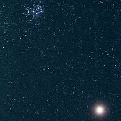
Image credit: Bob Christmas. Click to enlarge
Orion by Thomas Davis
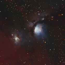
Image credit: Thomas Davis. Click to enlarge
Astrophoto: Dumbbell Nebula by R Jay GaBany
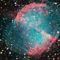
Image credit: R Jay GaBany. Click to enlarge
Hayabusa Landed on Itokawa Successfully
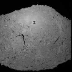
Hayabusa descending on Itokawa before landing. Image credit: JAXA Click to enlarge
Hayabusa attempted its first soft-landing on Itokawa for the purpose of touch down and sample collection on November 20-21, 2005. Below is the data information with the related advance report on its status.
Hayabusa started descending at 9:00pm on Nov. 19th, 2005 (JST) from 1km in altitude. The guidance and navigation during the process of approach was operated normally, and at 4:33am on Nov. 20th, the last approach of vertical descent was commanded from ground, of which soft-landing was successfully achieved almost on the designated landing site of the surface. Deviation from the target point is now under investigation but presumed within a margin of 30cm.
The velocity at the time of starting descent was 12cm/sec. At the altitude 54m at 5:28am, wire-cutting of target marker was commanded, after which, at 5:30am at altitude 40m, the spacecraft autonomously reduced its own speed by 9cm/sec to have substantially separated the target marker. It means that Hayabusa’s speed became 3 cm/sec. Separation and freefall of the marker was confirmed from the image as well as from descending velocity of the spacecraft at the time of reducing the speed. The marker is presumed to have landed on southwest of MUSES Sea.
Hayabusa then switched its range measurement from Laser Altimeter (LIDAR) to Laser Range Finder (LRF) at the altitude 35m and moved to hovering by reducing descending speed to zero at 25m above the surface, below where Hayabusa, at 5:40am at altitude 17m, let itself to freefall, functioning itself to the attitude control mode adjustable to the shapes of the asteroid surface. At this point, the spacecraft autonomously stopped telemetry transmission to the earth (as scheduled) to have changed to transmission with beacon mode more efficient for Doppler measurement by switching to low gain antenna (LGA) coverable larger area.
Since then, checking of the onboard instruments was not possible on a real time basis (as scheduled), but as a result of analyzing the data recorded onboard and sent back to the earth in the past two days, Hayabusa seemed to have autonomously judged to abort descending and attempted emergency ascent because its Fan Beam sensors for obstacle checking detected some kind of catch-light. Allowable margin is set for Hayabusa for its attitude control, in the case the spacecraft takes off the ground by accelerating the velocity on its own. Under such circumstances, the then spacecraft’s attitude was out of the margin, because of which continuing of safe descent was consequently chosen. As a result, Hayabusa did not activate its Touch Down Sensor function.
At the timepoint of Nov. 21, Hayabusa was judged not to have landed on the surface. According to the replayed data, however, it was confirmed that Hayabusa stayed on Itokawa by keeping contact with the surface for about 30 minutes after having softly bounced twice before settling. This can be verified by the data history of LRF and also by attitude control record.
This phenomenon took place during switching interval from Deep Space Network (DSN) of NASA to Usuda Deep Space Center, because of which the incident was not detected by ground Doppler measurement. The descending speed at the time of bouncing twice was 10cm/sec. respectively. Serious damage to the spacecraft has not been found yet except heating sensor that may need checking in some part of its instrument.
Hayabusa kept steady contacting with the surface until signaled from ground to make emergency takeoff at 6:58am (JST). The Touch Down Sensor supposed to function for sampling did not work because of the reason above stated, for which reason firing of projector was not implemented in spite of the fact that the spacecraft actually made landing. The attitude at landing is so presumed that the both bottom ends of +X axis of sampler horn and either the spacecraft or tip end of the solar panels was in contact with the surface. Hayabusa became the world-first spacecraft that took off from the asteroid. Really speaking, it is the world-first departure from an celestial body except the moon.
After departure from the asteroid by ground command, Hayabusa moved into safe mode due to the unsteady communication line and the conflict with onboard controlling and computing priority. The comeback from safety mode to normal 3-axis control mode needed full two days of Nov. 21 and 22. Owing to this reason, replaying of the data recorded on 20th is still midway, which means the possibility to reveal much more new information through further analysis of the data. As of now, the detailed image of the landing site to know its exact location has not been processed yet. Hayabusa is now on the way to fly over to the position to enable landing and sampling sequence again. It’s not certain yet if or not descent operation will be able to carry out from the night of Nov. 25 (JST). We will announce our schedule in the evening of Nov. 24.
Descending and landing operation will all depend upon availability of DSN of NASA. We would like to express our sincere gratitude for cooperation of NASA for tracking networks including backup stations.
Original Source: JAXA News Release
Eternally Lit Lunar Peaks

The lunar surface taken by SMART-1. Image credit: ESA Click to enlarge
While the Earth is tilted at an angle of about 23 degrees, the moon’s tilt is just over 1 degree. Because of this, the summits of some lunar crater rims are sunlit over very long periods. In some locations, there are “peaks of eternal light,” or pics de lumiere eternelle, as the French astronomer Camille Flammarion called them at the end of the nineteenth century.
NASA’s Clementine spacecraft orbited the moon for three months in 1994. It identified some spots in the north polar region that are illuminated all the time during the summer, and others that are illuminated 80 percent of the time. This was not a big surprise, because we know that on Earth the poles receive a lot of sunlight during the summer. A question that the European Space Agency wanted to answer with the SMART-1 mission was whether there is enough solar light to still illuminate these places in winter.
SMART-1 mapped the polar areas on the moon, and we recently found an illuminated site about 15 kilometers from the north pole. Even though most of the moon is dark in that region, there’s a crater wall tall enough for sunlight to strike its rim.
Such perpetually lit areas would be good places to start our exploration of the moon. If you didn’t want to rely on complex power systems, you could install solar power stations at the peaks and use the energy to run small rovers and landers. Such systems are easier to design than electrical and mechanical systems that must withstand the extreme variation of temperature between lunar day and night. Branching out from there, you could build a spider web of facilities and habitats, with the core feeding energy to surrounding areas.
A peak of eternal light would be a good place to retreat to in winter, where we could maintain low level operations. In the spring and summer, we could reach out to other parts of the moon, extending hundreds of kilometers from the core.
The peaks provide some temperature stability. On the moon’s equator, the temperature can vary from minus 170 degrees C to plus 110 degrees C. The peaks have less variation, and an average temperature of minus 30 degrees C. A solar collector placed on a peak could provide enough energy to maintain a habitat with a very comfortable temperature of 20 degrees C.
With such a stable environment, you could do life science experiments to test how life adapts on another world. We could see how bacteria withstand the radiation environment. We could develop plant growth experiments in preparation for human bases.
But we also want to know if different organisms can survive and proliferate in the extreme conditions of the moon. By experimenting with different temperatures, artificial pressure, and other factors, we could figure out whether we even needed to develop lunar greenhouses. Do we need to recreate an exact copy of Earth conditions, or can we just adapt aspects of lunar conditions and make use of local resources?
Some astronomers are interested in the peaks of eternal light. You could build a very large observatory, at some distance from a peak of eternal light, that could observe the universe unattended. Because there’s no atmosphere on the moon, sunlight does not get scattered, so you can make observations even during part of the daytime.
Finally, just as the moon’s axis of rotation produces peaks of eternal light, there are also places, like the bottoms of some craters near the poles, that are in permanent shadow. We are very interested in such craters because they may contain water ice. That could be a valuable resource for future bases on the moon.
So a peak of eternal light would be a good central base from which to begin our lunar activities. It could provide a source of solar power for exploration, astronomical observations, life science experiments, and the investigation of possible water in the dark craters.
To extend beyond a few hundred kilometers from the peaks, however, we would need to develop nuclear power systems. That would provide enough energy to allow us to grow from a little refuge to a global village on the moon.
Original Source: NASA Astrobiology
