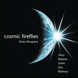
CD Review: Cosmic Fireflies

Story Musgrave flew into space six times. His training began in the Apollo era. He was capcom for many flights, including the Skylab missions, and he completed EVA’s, including repairs to Hubble. In total, he has logged over 1281 hours off of Earth’s surface. He certainly has had ample opportunity to reflect upon his circumstances and develop a sense of being space bound. Further, amongst his many accolades he has a master of arts in literature. This combination should remedy the typical astronauts angst at expressing feelings. And it does, as Musgrave, in his disc, portrays a warm, special dimension to space travel.

There are 13 separate tracks on the disc. They alternate between a poem with musical accompaniment and purely musical tracks. Musgrave wrote the poems and does his own recitations. His voice doesn’t have the polish of professional actors, yet enthusiasm and honest feelings are palpably present. And, of course, each of the spoken passages have a direct relation to space.

The first poem presents the ‘rush’ of the rockets launch. An underlying direct feed from an Atlantis launch amplifies the sensation. Another gives a timely and provocative recital of the changing views of Earth seen out the orbiting shuttle’s window. Still another tackles the justification for putting so much natural resources into space exploration. The title piece, Cosmic Fireflies, captures the bedazzlement, like fireworks, that astronauts envision while passing through the Earth’s magnetosphere. Each poem has its own rhythm and sense and each evokes an image or feeling well aligned with space. As a collection, they combine into a journey from the launch, through controlled flight and into the free floating realm that pushes to transcend the pull of gravity and even diminish the continual roar of competition.

The musical style is effectively new age with a touch of techno. Whether in accompaniment or standing alone, each softly encourages reflection and meditation. Perhaps not remarkable on their own, they are nevertheless perfect companions for the poems and add to the emotional journey the listener can travel upon.

This disc would be a perfect addition to an evening spent sitting by a fire and watching the stars. The slow dance of flames would balance with the music and words of the poems. Being outside, under the stars would give credence to the message of humankind’s place on or off planet Earth. However, though the words to the poems are available at the associated web site, it seems a shame that they weren’t included with the disc itself.

As much as people have the power of speech, sometimes we are still left speechless. The wonders of space, perhaps due to their novelty, seem to be well ahead of our descriptive ability. However, Story Musgrave in his compact disc Cosmic FireFlies seeks to redress this situation and the result is a pleasant musical journey and a simple moment for reflecting and pondering.

Visit Story Musgrave’s website at: www.spacestory.com

Listen to samples or purchase a copy of Cosmic Fireflies from Countdown Creations.

Review by Mark Mortimer.

Asteroid Will Zip Past the Earth in 2029

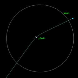
The orbits of Earth and asteroid 2004mn4. Image credit: NASA/JPL. Click to enlarge.
Friday the 13th is supposed to be an unlucky day, the sort of day you trip on your shoe laces or lose your wallet or get bad news.

But maybe it’s not so bad. Consider this: On April 13th–Friday the 13th–2029, millions of people are going to go outside, look up and marvel at their good luck. A point of light will be gliding across the sky, faster than many satellites, brighter than most stars.

What’s so lucky about that? It’s asteroid 2004 MN4 … not hitting Earth.

For a while astronomers thought it might. On Christmas Eve 2004, Paul Chodas, Steve Chesley and Don Yeomans at NASA’s Near Earth Object Program office calculated a 1-in-60 chance that 2003 qq47 would collide with Earth. Impact date: April 13, 2029.

The asteroid is about 320 meters wide. “That’s big enough to punch through Earth’s atmosphere,” devastating a region the size of, say, Texas, if it hit land, or causing widespread tsunamis if it hit ocean, says Chodas. So much for holiday cheer.

Asteroid 2004 MN4, also known as the 2029 meteor, had been discovered in June 2004, lost, then discovered again six months later. With such sparse tracking data it was difficult to say, precisely, where the asteroid would go. A collision with Earth was theoretically possible. “We weren’t too worried,” Chodas says, “but the odds were disturbing.”

This is typical, by the way, of newly-discovered asteroids. Step 1: An asteroid is discovered. Step 2: Uncertain orbits are calculated from spotty tracking data. Step 3: Possible Earth impacts are noted. Step 4: Astronomers watch the asteroid for a while, then realize that it’s going to miss our planet.

Killer Asteroid! headlines generally appear between steps 3 and 4, but that’s another story.

Astronomers knew 2004 MN4 would miss Earth when they found pictures of the 2029 asteroid taken, unwittingly, in March 2004, three months before its official discovery. The extra data ruled out a collision in 2029.

Instead, what we’re going to have is an eye-popping close encounter:

On April 13, 2029, asteroid 2004 MN4 will fly past Earth only 18,600 miles (30,000 km) above the ground. For comparison, geosynchronous satellites orbit at 22,300 miles (36,000 km). “At closest approach, the asteroid will shine like a 3rd magnitude star, visible to the unaided eye from Africa, Europe and Asia–even through city lights,” says Jon Giorgini of JPL. This is rare. “Close approaches by objects as large as 2004 MN4 are currently thought to occur at 1000-year intervals, on average.”

The asteroid’s trajectory will bend approximately 28 degrees during the encounter, “a result of Earth’s gravitational pull,” explains Giorgini. What happens next is uncertain. Some newspapers have stated that the asteroid might swing around and hit Earth after all in 2035 or so, but Giorgini discounts that: “Our ability to ‘see’ where 2004 MN4 will go (by extrapolating its orbit) is so blurred out by the 2029 Earth encounter, it can’t even be said for certain what side of the sun 2004 MN4 will be on in 2035. Talk of Earth encounters in 2035 is premature.”

In January 2004, a team of astronomers led by Lance Benner of JPL pinged 2004 MN4 using the giant Arecibo radar in Puerto Rico. (Coincidentally, the Arecibo dish is about the same size as the asteroid.) Echoes revealed the asteroid’s precise distance and velocity, “allowing us to calculate the details of the 2029 flyby,” says Giorgini, who was a member of the team along with Benner, Mike Nolan (NAIC) and Steve Ostro (JPL).

More data are needed to forecast 2004 MN4’s motion beyond 2029. “The next good opportunities are in 2013 and 2021,” Giorgini says. The asteroid will be about 9 million miles (14 million km) from Earth, invisible to the naked eye, but close enough for radar studies. “If we get radar ranging in 2013, we should be able to predict the location of 2004 MN4 out to at least 2070.”

The closest encounter of all, Friday the 13th, 2029, will be a spectacular opportunity to explore this asteroid via radar. During this encounter, says Giorgini, “radar could detect the distortion of 2004 MN4’s shape and spin as it passes through Earth’s gravity field. How the asteroid changes (or not) would provide information about its internal structure and material composition.” Beautifully-detailed surface maps are possible, too.

The view through an optical telescope won’t be so impressive. The asteroid’s maximum angular diameter is only 2 to 4 arcseconds, which means it will be a starlike point of light in all but the very largest telescopes.

But to the naked eye–wow! No one in recorded history has ever seen an asteroid in space so bright.

Friday the 13th might not be so bad after all.

Original Source: Science@NASA

Amateurs Command Gemini for an Hour

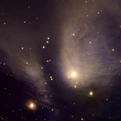
Gemini North image of stellar nursery RY Tau. Image credit: Gemini. Click to enlarge.
Using a giant telescope on Mauna Kea Hawaii is a dream for most amateur sky watchers. Recently a Canadian amateur astronomy group took advantage of a rare opportunity and used one of the largest telescopes in the world, the Gemini 8-meter telescope, to look more deeply into the remains of a particular stellar nursery than anyone ever has.

The observations of a star emerging from its cocoon were the result of a proposal submitted as part of a nationwide contest in Canada. The winning group from Quebec received its data/images during a special ceremony at the annual meeting of the Canadian Astronomical Society at the University of Montreal on May 15, 2005.

“Our group knew that this object was unique and hadn’t been observed in detail with a big telescope like Gemini,” said Gilbert St-Onge, the club member who submitted the proposal. “I feel like we’ve not only made a pretty picture, but probably provided some new and valuable data for the pros!”

Gemini Astronomer Tracy Beck, who studies these stellar incubators, agrees. “This object is a classic, and one of the first-known examples of this type of young star,” she said. “I believe this is by far the deepest and most detailed image ever taken of this object and scientists will no doubt use these data for important research in the future.”

The object, known as RY Tau is part of a class of objects known as T Tauri stars. These stars represent the very youngest of low-mass stellar specimens that have only recently emerged from the cocoon of gas and dust in which they formed. The new Gemini image of RY Tau displays a striking array of wispy gas filaments that glow from scattering caused by radiation from the nearby star. Over the next few million years this gas will be blown away by the central star leaving a normal star and perhaps a family of planets that also formed from gas and dust in the cloud.

The observations, which took a total of about one hour using the Gemini Multi-Object Spectrograph (GMOS), were challenging to make. The central star is so bright that it can overwhelm the faint glowing clouds around it. To overcome this, a series of many short exposures were obtained and stacked to produce the final image. A selection of four filters were also used to bring out specific color features in the dynamic cloud.

The program was sponsored by the team of scientists who coordinate Gemini observations for Canada (through the Canadian Gemini Office) at the National Research Council of Canada’s Herzberg Institute of Astrophysics (HIA) in Victoria. B.C. The contest, which began in 2004, solicited proposals from more than a hundred amateur astronomy clubs throughout Canada as a way to thank them for the work they do to support and excite the public about astronomy. The winning proposal was selected by a process similar to that used by professional astronomers, where selection criteria include scientific merit and an assessment of the uniqueness of the observation.

“When we first worked on scheduling these observations, we jokingly referred to the program as the “amateur hour” since it allows amateur astronomers to get an hour of time on a large telescope,” said Doug Welch, Canadian Gemini Project Scientist. “However, the caliber of the proposals and scientific potential of this data has shown that it is more like a pro-am golf tournament where the hobbyists work directly with the pros!”

The contest also included an hour of time on Gemini’s neighbor on Mauna Kea, the Canada-France-Hawaii Telescope (CFHT). The winning observation at CFHT was from a group in Alberta, Canada who used the wide-field capability of the telescope to image a large field of the Pleiades star cluster with the MegaPrime imager.

Original Source: Gemini News Release

B-15 About to Crash Again

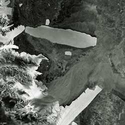
ESA’s Envisat image of iceberg B-15A. Image credit: ESA. Click to enlarge.
The mammoth B-15A iceberg appears poised to strike another floating Antarctic ice feature, a month on from a passing blow that broke off the end of the Drygalski ice tongue. As this Envisat image reveals, this time its target is the ice tongue of the Aviator Glacier.

First discovered in 1955, and named to mark the work done by airmen to open up the Antarctic continent, the Aviator Glacier is a major valley glacier descending from the plateau of Victoria Land along the west side of the Mountaineer Range. It enters the sea at Lady Newnes Bay, where it forms a floating ice tongue that extends into the water for about 25 kilometres.

This Envisat Advanced Synthetic Aperture Radar (ASAR) image was acquired on 16 May 2005 in Wide Swath Mode (WSM), providing spatial resolution of 150 metres across a 400-km swath. ASAR can pierce through clouds and local darkness and is capable of differentiating between different types of ice.

The sensor has been following the movements of B-15A since the beginning of the year, gathering the highest frequency weather-independent dataset of this part of the Ross Sea.

Measuring around 115 kilometres in length with an area exceeding 2500 square kilometres, the B-15A iceberg is the world’s largest free-floating object. It is the largest remaining section of the even larger B-15 iceberg that calved from the Ross Ice Shelf in March 2000 before breaking up into smaller sections.

Since then its B-15A section has drifted into McMurdo Sound, where its presence blocked ocean currents and led to a build-up of sea ice that decimated local penguin colonies, deprived of open waters for feeding. During the spring of this year prevailing currents took B-15A slowly past the Drygalski ice tongue. A full-fledged collision failed to take place, but a glancing blow broke the end off Drygalski in mid-April.

The stretch of Victoria Land coast parallel to B-15A’s current position is unusually rich in wildlife, noted for colonies of Adelie penguins as well as Weddell seals and Skuas. If B-15A were to remain in its current position for any prolonged length of time, the danger is that the iceberg could pin sea-ice behind it, blocking the easy access to open water that local animal inhabitants currently enjoy.

Twin-mode Antarctic observations
Envisat’s ASAR instrument monitors Antarctica in two different modes: Global Monitoring Mode (GMM) provides 400-kilometre swath one-kilometre resolution images, enabling rapid mosaicking of the whole of Antarctica to monitor changes in sea ice extent, ice shelves and iceberg movement.

Wide Swath Mode (WSM) possesses the same swath but with 150-metre resolution for a detailed view of areas of particular interest.

ASAR GMM images are routinely provided to a variety of users including the US National Oceanic and Atmospheric Administration (NOAA) National Ice Centre, responsible for tracking icebergs worldwide.

ASAR imagery is also being used operationally to track icebergs in the Arctic by the Northern View and ICEMON consortia, which provide ice monitoring services as part of the Global Monitoring for Environment and Security (GMES) initiative, jointly backed by ESA and the European Union.

This year also sees the launch of CryoSat, a dedicated ice-watching mission designed to precisely map changes in the thickness of polar ice sheets and floating sea ice.

CryoSat, in connection with regular Envisat ASAR GMM mosaics and SAR interferometry – a technique used to combine radar images to measure tiny centimetre-scale shifts between acquisitions – should answer the question of whether the kind of ice-shelf calving that gave rise to B-15 and its descendants are a consequence of ice sheet dynamics or other factors.

Together they will provide insight into whether such iceberg calving occurrences are becoming more common, as well as improving our understanding of the relationship between the Earth’s ice cover and the global climate.

Original Source: ESA News Release

What’s Up This Week – May 16 – May 22, 2005

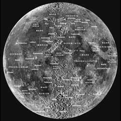
Lunar Map courtesy of The Sky Plus. Click to enlarge.
Monday, May 16 – With the Moon now approaching first quarter, this would be an excellent time to look for it in late afternoon skies. If you’re not busy this evening, why don’t we take the opportunity to explore the lunar surface and look at four very cool features.

Central on the terminator tonight will be Sinus Medii – the adopted “center” of the lunar disc and the point from which latitude and longitude are measured. This smooth plain may look small, but covers about as much area as the states of Massachusetts and Connecticut combined. On a curious note, in 1930 Sinus Medii was chosen by Edison Petitt and Seth Nicholson for surface temperature measurements during full Moon. Experiments of this type were began by Lord Rosse as early as 1868, and they found the surface to be just slightly warmer than boiling water. Around a hundred years after such experiments began, Surveyor 6 successfully landed in Sinus Medii on November 9, 1967 confirming Surveyor 5’s findings – and became the very first probe to “lift off” from the lunar surface.

To the south/southeast of the Sinus Medii is the unmistakable Albategnius. It is an old formation, with its walls broken by many more recent craters, like Klein on its southwestern edge. Albategnius is historic as well, because in 1962, it became the target of the laser beam projected onto the lunar surface. To the north, look for the long dark scar of the Alpine Valley as it angles across the lunar Alps and the Sun beginning to rise on the single, unusual peak of pyramid-like Mons Piton.

Tuesday, May 17 – Today in 1835, J. Norman Lockyer was born. While that name might not stand out, Lockyer was the first to note previously unknown absorption lines while making visual spectroscopic studies of the Sun in 1868. Little did he know at the time, he had correctly identified the most simple and second most abundant element in our universe – helium – an element not discovered on Earth until 1891! Also known as the “Father of Archeoastronomy”, Sir Lockyer was one of the first to make the connection with ancient astronomical structures such as Stonehenge and the Egyptian pyramids. (As a curious note, 14 years after Lockyer’s notation of helium, a sun-grazing comet made its appearance in photographs of the solar corona taken during a total eclipse in 1882… It hasn’t been seen since.)

If you would like to see a helium rich star, look no further tonight than Alpha Viginis – Spica. As the sixteen brightest star in the sky, this brilliant blue/white “youngster” appears to be about 275 light years away and is about 2300 times brighter than our own Sun. Although we can not see it visually, Spica is a double star. Its spectroscopic companion is roughly half its size and is also helium rich.

Feeling like some peaceful contemplation? Then visit the lunar surface tonight and spend some time with crater Plato. This huge ellipse to the lunar north has an unusual dark stained lava floor that has been the site of many unconfirmed changes. Visit along its east wall where the shadow play among its many crests will appear almost like a distant city skyline.

Wednesday, May 18 – On this day in 1910, Comet Halley transited the Sun, but could not be detected visually. Since the beginning of astronomical observation, transits, eclipses and occultations have provided science with some very accurate determinations of size. Since Comet Halley could not be spotted against the solar surface, we knew almost a century ago that the nucleus had to be smaller than 100 km.

So, would you like to get a grasp on that concept? Then have a look at the lunar surface tonight and the most prominent crater of all – Copernicus. In a study done by Shoemaker, this ancient crater is no doubt formed by a gigantic impact. Feature after feature so closely resembles geological impact craters seen here on Earth, that we can say with complete certainty that this crater was formed by a large meteoritic body. And just how large is crater Copernicus? Oh, about the size of a certain famous comet’s nucleus – 100 km…

Thursday, May 19 – Tonight on this universal date, the Moon will occult Jupiter for viewers in a small portion of south Africa and the northern tier of South America. Please visit this IOTA webpage for specific times in your location. For viewers in North America, the Moon and Jupiter will make a very picturesque sight as they pass very closely to each other.

While watching this pair tonight, take the time to look at the lunar surface and enjoy the “Bay of Rainbows” – Sinus Iridium. If you’re watching Jupiter, a great many viewers will get to enjoy the both the transits of Io and Europa as well as their shadows and the “Great Red Spot” will happily join the show at 22:10 UT.

Friday, May 20 – Tonight let’s skip the Moon and head for the stars as we set our sights towards the fourth brightest star in the sky – Arcturus.

Located around 37 light years from us, the orange giant is heading our way at about 5 kilometers per second and will pass us in a couple of thousand years. With a diameter of roughly 33 million kilometers, this population II star was one of the very first to be observed during the daylight in 1635 and is often referred to as the “Watcher of the Bear”. Oddly enough, it reached fame in 1933 when its light was focused telescopically on a photoelectric cell and the power it generated used to turn on a switch. That switch was connected to the floodlights at the Chicago Exposition “Century of Progress” – with Arcturus chosen for the honors because the light that reached the Earth that night had left the star during the Chicago 1893 Exposition. Here’s to guessing you couldn’t see Arcturus once the lights were on….

But keep your lights off and your eyes trained on the finderscope as we explore four “neighbors” of Arcturus. About a fist width east, you will see four dim stars that will require optical aid with tonight’s “lunacy”. To the north is Xi – a very pretty double star with a yellowish primary and a more orange secondary. The next star to the south is Omicron and then Pi. You will find Pi to be a 5th magnitude double with a 6th magnitude companion relatively close to the east/southeast. For larger scopes, keep heading south for double Zeta, which are matched magnitudes and close enough to need high power and steady skies to split.

Saturday, May 21 – In 1961, United States President John F. Kennedy launches the country on a journey to the Moon as he makes one of his most famous speeches to Congress: “I believe this nation should commit itself to achieving the goal, before this decade is out, of landing a man on the Moon and returning him safely to Earth. No single space project in this period will be more impressive to mankind, or more important for the long-range exploration of space…”

Tonight let’s explore the lunar surface with binoculars as we view the areas of all the historic Apollo missions. Starting with Apollo 11, you will find its landing site on the southwest corner of Mare Tranquillitatus where it meets with Mare Nectaris. Apollo 12 is near the terminator to the west and just north of the small, bright punctuation of Euclid. Apollo 14’s remains lay due east on the border of Mare Cognitum. Look to the north for shallow Archimedes and the Apennine Mountain range where you will find Apollo 15 forever waiting in Palus Putredinus. Look southeast of Apollo 11’s site in the rugged terrain west of Theophilus for Apollo 16, and Apollo 17 ends the lunar tour on the southeastern shore of Mare Serenitatis where it joins Mare Nectaris.

Since you’re out with binoculars, tonight would be a great opportunity to spot an asteroid as well! At close to 7th magnitude, you’ll find Ceres just about a degree south of Delta Librae. Check the minor planets listing at Heaven’s Above for a locator chart.

Sunday, May 22 – Tonight the Moon will be at minimum libration tipping crater Otto Struve our way. You will find this strange, tomato-shaped crater on the extreme limb just west of bright Aristarchus.

Since Struve was the master of double stars, let’s make it easy to find one of his discoveries! Start with reasonably accurate equatorial alignment and take the time to enjoy fantastic double Cor Caroli again. Turn off any drive units, or just wait… Wide, white double, Struve 1702 will “drift” into the eyepiece in 150 seconds.

Until next week? Ask for the Moon, but keep reaching for the stars! May all your journeys be at Light Speed… ~Tammy Plotner
Book Review: The Road to Reality

Physics, the study of what we observe, and mathematics, the study of relationships, are intimately intertwined. Often where one goes, the other quickly follows. One may lay the frame work, while the other fleshes out the tone and texture. Roger Penrose, the Emeritus Rouse Ball Professor of Mathematics at Oxford University, has been lecturing since at least the early 1960’s. His passion is twistor theory, an alternative to the contemporary continuous spacetime associated with Einstein’s theory and standard quantum mechanics. Twistor theory and others look to define a grand unifying theory (the math) to combine spacetime, gravity and the probabilistic properties of quanta (the observed).

Penrose in his book, however, doesn’t shove the reader into the deep end of theories without any floatation. Twistor theory, string theory and others reside at the very end. The beginning covers the elemental mathematics. Using qualitative language and expressions such as ‘beautiful’ and ‘elegant’, he relates back to the Greeks and number theory, then on through geometry (similar triangles) and complex numbers (i) to end up with functions. Of course, functions aren’t themselves a destination, they are just a jumping off point for calculus, surfaces, manifolds and spaces. Using all the tricks of the lecturer’s trade, Penrose does an admirable job in delivering knowledge solely from the pages. Diagrams and graphs bring vision to abstract notions of infinite spaces, bundles, n-surfaces and manifolds. Layouts for thought experiments (e.g. photon travel to Titan) convey a simple view to many arguments. Problems sprinkled throughout the book, much like homework assignments, force the reader to delve deeper into certain points of view. And of course, copious references, whether to seminal articles by Newton or recent accounts by today’s researchers, litter the paragraphs and these each trace to expansive notes at the chapter’s end. Given this aid, there certainly is no cause to drown while wading through the complexity of the ideas within.

For yes, the ideas within are complex. Even though no prior knowledge is assumed, some formal training in mathematics or physics would certainly aid the reader. The relative significance and value of Riemann surfaces, conformal mappings and holomorphic functions aren’t readily apparent to the mathematic novice though each has importance. But don’t dismay, for as math is the basis, it isn’t presented for its own sake, rather for its value in contributing to our knowledge of the physics. For example, appropriate math and physics led to the relationship of energy to matter which led to the field of nuclear science. Quantum computing is progressing along the same lines. These are discussed as well as black holes, the dual wave and particle nature of photons, the esoteric nature of gravity and the entropic flow of our universe. For it is the qualities of these elements, such as their reflective or invariant attributes, that must be mirrored in the mathematical relations that model them. Though complex, for those who enjoy this subject, the presentation is invigorating, well paced and thorough.

There is, however, an admitted touch of bias in that Penrose is more contradictory than supportive when it comes to the direction taken by some of today’s researchers. He is certainly not supportive of string theory. He recites many short comings of this as well as his own favourite, twistor theory. Other theories get their comeuppance. In a philosophical section, he goes so far as to contemplate reviewing the current bases for modelling the physics or re-examining the meaning of reality. This is perhaps where the title of the book originates, but still the title seems a bit out of place. The theme of a road never appears in the book, nor is that of reality much included. This book does, however, provide a great mathematical basis for pursuing the investigation of physics. It doesn’t shirk from raising difficulties, dead ends or complete unknowns. With the citations and the progressively more current subject matter, a reader can easily dive in to learn more or maybe to select an area to make their own contribution.

A grand unifying theory is a bit of a holy grail for some mathematicians and physicists. Continual progress is trumpeted through the journals and maybe the theory is just around the next corner. To be prepared for this, or to perhaps consider making your own contribution, read The Road to Reality by Roger Penrose, a smoothly written, finely scoped book showing the contributions that math is making in this and other searches of the physics of nature.

Read more reviews or purchase a copy online from Amazon.com.

Review by Mark Mortimer.

Mystery of Martian Icecaps Explained

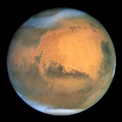
Hubble view of Mars, including its polar ice caps. Image credit: NASA. Click to enlarge.
NASA scientists have solved an age-old mystery by finding that Mars’ southern polar cap is offset from its geographical south pole because of two different polar climates.

Weather generated by the two martian regional climates creates conditions that cause the red planet’s southern polar ice to freeze out into a cap whose center lies about 93 miles (150 kilometers) from the actual south pole, according to a scientific paper included in the May 12 issue of the journal, Nature.

“Mars’ permanent south polar cap is offset from its geographic south pole, which was a mystery going back to the first telescopic observations of Mars,” said the paper’s lead author, Anthony Colaprete, a space scientist from NASA Ames Research Center, located in California’s Silicon Valley. “We found that the offset is a result of two martian regional climates, which are on either side of the south pole,” he said.

The scientists found that the location of two huge craters in the southern hemisphere of Mars is the root cause of the two distinct climates.

“The two craters’ unique landscapes create winds that establish a low pressure region over the permanent ice cap in the western hemisphere,” Colaprete explained.

Just as on Earth, low-pressure weather systems are associated with cold, stormy weather and snow. “On Mars, the craters anchor the low pressure system that dominates the southern polar ice cap, and keep it in one location,” Colaprete said.

According to the scientists, the low-pressure system results in white fluffy snow, which appears as a very bright region over the ice cap. In contrast, the scientists also report that ‘black ice’ forms in the eastern hemisphere, where martian skies are relatively clear and warm.

“The eastern hemisphere of the south pole region gets very little snow, and clear ice forms over the martian soil there,” Colaprete said. Black ice forms when the planet’s surface is cooling, but the atmosphere is relatively warm, according to scientists. “A similar process occurs on Earth when black ice forms over highways,” Colaprete explained.

Colaprete’s co-authors include Jeffrey Barnes, Oregon State University, Corvallis; Robert Haberle, also of NASA Ames; Jeffery Hollingsworth, San Jose State University Foundation, NASA Ames; and Hugh Kieffer and Timothy Titus, both from the U.S. Geological Survey, Flagstaff, Ariz.

Original Source: NASA News Release

Probing the Atmosphere of an Extrasolar Planet

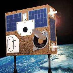
The suitcase-sized MOST space telescope. Image credit: MOST. Click to enlarge.
MOST, Canada’s first space telescope, has turned up an important clue about the atmosphere and cloud cover of a mysterious planet around another star, by playing a cosmic game of `hide and seek’ as that planet moves behind its parent star in its orbit.

The exoplanet, with a name only an astrophysicist could love, HD209458b (orbiting the star HD209458a), cannot be seen directly in images, so the scientists on the MOST (Microvariability & Oscillations of STars) Satellite Team have been using their space telescope to look for the dip in light when the planet disappears behind the star. “We can now say that this puzzling planet is less reflective than the gas giant Jupiter in our own Solar System,” MOST Mission Scientist Dr. Jaymie Matthews announced today at the annual meeting of the Canadian Astronomical Society in Montréal. “This is telling us about the nature of this exoplanet’s atmosphere, and even whether it has clouds.”

Many of the planets discovered around other stars, known as exoplanets or extrasolar planets, hug surprisingly close to their parent stars; HD209458b orbits at only 1/20th of the Earth-Sun distance (an Astronomical Unit or AU). It could never support life as we know it. But understanding HD209458b is a key piece in the puzzle of planet formation and evolution that is revising theories of our own Solar System, and estimates of how common are habitable worlds in our Galaxy. How a giant ball of gas that is larger than the planet Jupiter (which orbits 5 AU from our Sun) got so close to its star, and how its atmosphere responds to the powerful radiation and gravitation fields of that star, are still open questions to exoplanetary scientists.

“The way this planet reflects light back to us from the star is sensitive to its atmospheric composition and temperature,” describes Jason Rowe, a Ph.D. student at the University of British Columbia who processed the MOST data. “HD209458b is reflecting back to us less than 1/10,000th of the total visible light coming directly from the star. That means it reflects less than 30-40% of the light it receives from its star, which already eliminates many possible models for the exoplanetary atmosphere.” By comparison, the planet Jupiter would reflect about 50% of the light in the wavelength range seen by MOST.

“Imagine trying to see a mosquito buzzing around a 400-Watt streetlamp. But not at the street corner, or a few blocks away, but 1000 km away!” explains Dr. Matthews. “That’s equivalent to what we’re trying to do with MOST to detect the planet in the HD209458 system.”

The planet was detected directly earlier this year in the infrared by NASA’s US$720M Spitzer Space Observatory. At a wavelength of 24 micrometres, about 50,000 times longer than the light waves seen by human eyes, the exoplanet HD209458b is actually faintly glowing, with what physicists call “thermal emission.” MOST looks at the Universe in the same wavelength range as the eye. By combining the Spitzer far-infrared thermal result with the MOST visible light reflection limit, theoreticians are now able to develop a realistic model of the atmosphere of this so-called “hot Jupiter.”

And MOST has not given up on HD209458b. “It can orbit, but it can’t hide,” quips Dr. Matthews. “MOST will put this system under a 45-day stakeout at the end of the summer to continue to improve our detection limit. Eventually, the planet will emerge from the noise and we’ll have a clearer picture of the composition of the exoplanet atmosphere and even its weather – temperature, pressure and cloud cover.”

A scientific paper on these results will be submitted soon, by Jason Rowe and Dr. Jaymie Matthews (UBC), Dr. Sara Seager (Carnegie Institute of Washington), Dr. Dimitar Sasselov (Harvard-Smithsonian Center for Astrophysics), and the rest of the MOST Science Team, with members from UBC, the University of Toronto, Université de Montréal, St. Mary’s University, and the University of Vienna.

Dr. Seager, a world leader in the field of modelling exoplanet atmospheres, emphasises the challenge of this kind of science: “We’re like weather forecasters trying to understand winds and clouds on a world we can’t even see. It’s hard enough for meteorologists to tell you whether it will be cloudy tomorrow in your hometown here on Earth. Imagine what it’s like to try to forecast weather on a planet 150 light years away!”

Dr. Sasselov is also excited by MOST’s early findings: “This capability of MOST is paving the way to the great prize – the discovery of Earth-sized planets. The search for other worlds like home is now on.” Dr. Matthews can’t resist adding, “Not bad for a space telescope with a mirror the size of a pie plate and a price tag of Can$10M, eh?”

MOST (Microvariability & Oscillations of STars) is a Canadian Space Agency mission. Dynacon Inc. of Mississauga, Ontario, is the prime contractor for the satellite and its operation, with the University of Toronto Institute for Aerospace Studies (UTIAS) as a major subcontractor. The University of British Columbia (UBC) is the main contractor for the instrument and scientific operations of the MOST mission. MOST is tracked and operated through a global network of ground stations located at UTIAS, UBC and the University of Vienna.

Original Source: CASCA News Release

Testing Strategies to Get Opportunity Unstuck

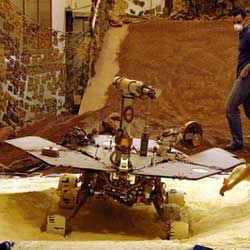
NASA engineers working with testing rover to get it unstuck. Image credit: NASA/JPL. Click to enlarge.
Mars rover engineers are using a testing laboratory to simulate specific Mars surface conditions where NASA’s rover Opportunity has spun its wheels in a small dune. Careful testing is preceding any commands for Opportunity to resume moving to get out of the dune and continue exploring.

The rover team at NASA’s Jet Propulsion Laboratory, Pasadena, Calif., has cooked up recipes combining various sandy and powdery materials for the best simulation on Earth of the dune where Opportunity dug itself in to wheel-hub depth last week. The team has not asked Opportunity to turn its wheels at all since the rover bogged down during a drive on April 26.

“We choose to proceed cautiously, so we don’t expect to begin actually driving out of the dune before next week, possibly later,” said Jim Erickson, rover project manager at JPL. “Both Opportunity and Spirit have already provided many more months of scientific exploration than anyone expected. By taking good care of them, we hope to keep them exploring for more months to come. Tests so far have sustained our optimism about Opportunity’s ability to drive out of this dune, but we have more testing ahead to understand how robust that capability is.”

Opportunity had driven about 40 meters (131 feet) of a planned 90-meter (295-foot) drive on the rover’s 446th martian day when its wheels began slipping. The rover was driving backwards at the time. The team frequently alternates between backwards and forwards driving to keep wheel lubrication well distributed. The wheels kept rotating enough times to have covered the rest of the distance if they hadn’t been slipping, but the rover eventually barely inched forward. After a turn at the end of the planned drive, Opportunity sensed that it had not turned properly and stopped moving.

Opportunity is positioned across the ridge of an elongated dune or ripple of soft sand that is about one-third meter (one foot) tall and 2.5 meters (8 feet) wide. “We’ve climbed over dozens of ripples, but this one is different in that it seems to be a little taller and to have a steeper slope, about 15 degrees on part of its face,” said Mark Maimone, a JPL rover mobility engineer.

Last week, engineers arranged a simulated dune using sand that was already at JPL’s rover testing facility and put a test rover into a comparably dug-in position. The test rover had no difficulty driving away, even when sunk in belly-deep. However, that sand offered better traction than the finer, looser material that appears to make up the surface at Opportunity’s current position. “We needed to do tests using material more like what Opportunity is in, something that has a fluffier texture and cakes onto the wheels,” said JPL rover engineer Rick Welch, who is leading the tests.

Experimenting with different mixtures, engineers and scientists came up with a recipe that includes play sand for children’s sandboxes, diatomaceous earth for swimming pool filters and mortar clay powder. Then they went to several home supply and hardware stores to find enough bags and boxes of the ingredients to make more than 2 tons of the simulated Mars sand for more realistic mobility tests, said JPL rover mobility engineer Jeff Biesiadecki.

Dr. Robert Sullivan of Cornell University, Ithaca, N.Y., a rover science team member, worked with engineers in the JPL testbed to match the properties of the test sand as closely as possible with those of the sand beneath Opportunity, based on images of wheels and wheel tracks on Mars. “We found that when the wheels dig in, the material we’re using does stick to the wheels and fills the gaps between the cleats, but it doesn’t stick when you’re just driving over it. That’s good because it’s the same as what we see in the images from Opportunity,” Sullivan said.

Experiments indicate that in this more powdery material, the test rover positioned comparably to Opportunity can drive out after some initial wheel-spinning. More testing, analysis, planning and review will precede any actual commands for Opportunity to begin driving away from the dune.

Meanwhile, Opportunity has been using its cameras to study its surroundings at the edge of a region called “Etched Terrain.” Since landing more than 15 months ago, it has driven 5.35 kilometers (3.32 miles). Spirit, halfway around Mars, has recently been using all of its research tools to examine an outcrop called “Methuselah,” the first outcrop of layered rock that Spirit has found. The rover has also been taking short movies of dust-carrying whirlwinds called “dust devils.” On some afternoons, the rover sees several at once moving across the plain. Spirit has driven a total of 4.31 kilometers (2.68 miles).

Original Source: NASA News Release

Mosaic of Titan’s Surface

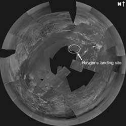
Mosaic of Huygens’ Titan images showing its landing spot. Image credit: ESA. Click to enlarge.
As the large amount of data collected by the ESA Huygens probe during its descent onto Titan is being processed, new views of this fascinating world become available.

The Descent Imager Spectral Radiometer (DISR) team have now produced the first complete ?stereographic? and ?gnomonic? mosaic images. Using special image projection techniques, the team combined a series of images captured by Huygens while rotating on its axis at an altitude of about 20 kilometres.

The DISR on board Huygens took its series of photographs of the ever-approaching surface in sets of three, or ?triplets?, as it dropped through Titan?s atmosphere on 14 January this year. The images sent back to Earth partially overlap, due to the probe?s rotation during the descent and due to the overlap between the fields of view of the different cameras.

DISR scientists are studying these images for similarities, such as physical features common to more than one image, and are constructing ?mosaics?, like jigsaw puzzles.

There are many different ways of rendering three-dimensional objects into two dimensions. Different kinds of projections for maps or photographs are able to represent realistically things like size, areas, distances and perspective. One particular kind of projection used for spheres in two dimensions (for example on some maps of Earth or the celestial sphere) is ?stereographic? projection.

A ?gnomonic? projection has also been produced, and this tends to make the surface appear as if it was flat. This type of projection is often found on maps used by navigators and aviators in determining the shortest distance between two points. However there is a lot of distortion of scale at the outer edges of gnomonic projections.

On the stereographic view, like that through a ?fish-eye? lens, the bright area to the north (top of the image) and west is higher than the rest of the terrain, and covered in dark lines that appear to be drainage channels. These lead down to what appears to be a shoreline with river deltas and sand bars.

The current interpretation of these lines is that they are cut by flowing liquid methane. Some of them may have been produced by precipitation run-off, producing a dense network of narrow channels and features with sharp branching angles. Some others may have been produced by sapping or sub-surface flows, giving shape to short stubby channels that join at 90 degree angles.

The largest run off channel starts at about the 12 o?clock position from an inlet on the shoreline and stretches to the left. The largest sapping channel starts at the 9 o? clock position and goes in a straight line up and left. The dark wide corridor to the west just below the sapping channel appears to be a major flow channel that empties into the mud flats of the lakebed.

The bright shapes to the north-east and east look to be ridges of ice gravel that are slightly higher than the flats around them, and the probe landing is believed to be just south-west of the semi-circular shape. The light and dark areas to the south are still of unknown nature.

On the gnomonic projection, the landing site is approaching and the surface features become sharper. North is at the top of the image. From lower left to upper right appears to be a ridge of ice boulders projecting through the darker lakebed material.

They are thought to slow the major flow from the west and cause the fluid to pond on the north-west side of the image, causing sedimentation of the dark material. Seepage between the boulders cuts the sediment into channels as the fluid continues to the south-east.

The members of the Huygens DISR instrument team are based throughout the USA and Europe, with the largest contributing groups from the University of Arizona, USA, the Max Planck Institute, Germany, and the Paris Observatory, Meudon, France.

Original Source: ESA News Release