50th GPS Satellite Launched

Image credit: Boeing
The 50th satellite launched for the U.S. Air Force Global Positioning System (GPS), GPS IIR-11, was delivered to space today by a Boeing [NYSE: BA] Delta II rocket.

The three-stage configuration Delta II launch vehicle lifted off from Space Launch Complex 17B at Cape Canaveral Air Force Station, Fla., at 12:53 p.m. EST.

GPS IIR-11 was successfully deployed to a transfer orbit following a 68-minute flight, where it will join the 24-satellite system.

?Today?s launch is a significant milestone for the Boeing Delta team,? said Will Trafton, vice president and general manager, Boeing Expendable Launch Systems. ?Our team?s commitment to mission assurance has played a critical role in the success of the GPS program and the services it provides to the U.S. military as well as civilian users around the world.?

Boeing Delta II rockets have launched all of the Block II GPS satellites making up the current operating constellation.

The successful deployment to space of GPS satellites aboard Delta II rockets has enabled the U.S. military to utilize GPS to assist aircraft, ships, land vehicles and ground personnel using handheld devices.

GPS also provides directional guidance for the freefall flight of the Boeing-built Joint Direct Attack Munition (JDAM) smart weapon system, which has successfully been used in the war on terrorism.

GPS provides military and civilian users three-dimensional position location data in longitude, latitude and elevation as well as precise time and velocity.

The Air Force Space Command administers the GPS program, which is operated by the 50th Space Wing at Schriever Air Force Base, Colo.

The next mission for the Delta team is the launch of Gravity Probe B for NASA aboard a Delta II, scheduled for launch in April from Vandenberg Air Force Base, Calif.

A unit of The Boeing Company, Integrated Defense Systems is one of the world?s largest space and defense businesses. Headquartered in St. Louis, Boeing Integrated Defense Systems is a $27 billion business. It provides systems solutions to its global military, government and commercial customers. It is a leading provider of intelligence, surveillance and reconnaissance; the world?s largest military aircraft manufacturer; the world?s largest satellite manufacturer and a leading provider of space-based communications; the primary systems integrator for U.S. missile defense; NASA?s largest contractor; and a global leader in launch services.

Original Source: Boeing News Release

Paul Allen Funds Next Stage of SETI Project

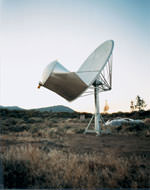
Image credit: SETI Institute
Investor and philanthropist Paul G. Allen has committed $13.5 million to support the construction of the first and second phases of the Allen Telescope Array (the ATA-32 and ATA-206), the world’s newest multiple use radio telescope array. The ATA will eventually consist of 350 ? 6.1-meter dishes (ATA-350), when construction is completed late in the decade. The announcement was made today by Thomas Pierson, chief executive officer for the SETI Institute, a leading astrobiology institution with the mission of exploring the origin, nature and prevalence of life in the universe. The ATA is a partnership between the SETI Institute and the Radio Astronomy Laboratory of the University of California, Berkeley (RAL).

Today’s announcement follows the successful completion of a three-year research and development phase which was originally funded by an $11.5 million gift from the Allen Foundation. The R & D proved that one of the primary advantages of the array design ? its scalability ? makes it possible for the ATA to conduct scientific investigations as soon as the first 32 dishes are installed.

Pierson also announced that the ATA-32 is scheduled to begin conducting scientific investigations by the end of 2004, significantly earlier than the 350 element array can be completed.

The ATA will be a general-purpose radio telescope that will provide fundamentally new measurements and insights into the density of the very early universe, the formation of stars, the magnetic fields in the interstellar medium, and a host of other applications of deep interest to astronomers. At the same time, this 21 st Century radio telescope will also have the capability to search for possible signals from technologically advanced civilizations elsewhere in the galaxy.

“I am very excited to be supporting one of the world’s most visionary efforts to seek basic answers to some of the fundamental question about our universe and what other civilizations may exist elsewhere,” said Paul G. Allen, primary funder of the ATA. “I am a big proponent of leveraging revolutionary technology and design and applying it to important problems in science. The developments taking place with this new instrument will not only enables us to realize a lot of bang for our research and development buck, but it will also change the landscape of how telescopes will be built in the future. An instrument of this magnitude, which will result in the expansion of our understanding of how the universe was formed, and how it has evolved, and our place therein, is the reason I am the primary supporter of its development, design and construction.”

Allen’s $13.5 million funding, structured as a challenge grant, will allow construction and operation of the first phase of 32-dishes by the end of the year. It will also support construction of the second phase of 174 additional dishes (the ATA-206), which is contingent upon fulfilling the Foundations’ challenge grant, in response to which the Institute will raise $16 million in additional support.

?It is especially thrilling to see the Allen Telescope Array approach its first significant milestone,? said SETI Institute CEO Tom Pierson. ?We are grateful for the additional support from the Allen Foundation that is making this new facility ? and further discovery ? possible. Mr. Allen and his Foundation have set the bar high. Mr. Allen’s support of this worthwhile project, when matched by other supporters of radio astronomy and SETI, will quickly bring this project to fruition.?

The ATA is the result of a multi-faceted private-public partnership between the SETI Institute and the RAL. It differs in practice, appearance, and cost from traditional radio telescopes currently in use. When completed, the ATA-350 will be among the world’s largest and fastest observing instruments.

Rather than a single enormous dish or several large dishes, the ATA will be constructed using hundreds of specially produced small dishes. The telescope will incorporate innovative technologies and modern, miniaturized electronics in concert with increasingly affordable computer processing. These new technologies, combined with the ability to conduct continuous observations, will increase SETI search speed by 300 times over previous efforts and simultaneously allow astronomers to conduct complex radio astronomy projects requiring long-term observations. And the instrument will achieve these goals at one-fifth the cost of traditional radio telescopes of comparable collecting area and complexity.

In its first phase, the ATA-32 will have more antennas than any of the world’s other centimeter-wavelength radio telescopes. The individual antennas will be linked by fiber optics. The fiber, power, and air distribution systems will be installed in ten-antenna ?nodes,? an efficient way to maintain the cool operating temperature required by the equipment.

The ATA-32 will observe in the direction of the galactic anti-center to detect primordial deuterium, study dark matter in nearby dwarf galaxies, generate maps of polyatomic molecules in molecular clouds, and conduct a SETI survey of the inner galaxy.

?I am eager to begin observing on the ATA,? commented Dr. Jill C. Tarter, ATA project leader and Director of the Center for SETI Research at the Institute. ?Conducting observations 24/7 is a dream come true for any astronomer, and it is particularly exciting for the Institute’s astronomers, who have been constrained by limited time on other large centimeter wavelength telescopes. Finally, our tools are becoming commensurate with the size of our task.?

Scientists believe that radio waves, such as those commonly produced by a variety of technologies on Earth and traveling at light-speed through interstellar space, may offer the easiest way to detect evidence of a technologically sophisticated civilization elsewhere in the galaxy. With sufficient collecting area, it is possible to detect signals from a distant technology that are no more powerful than those produced on Earth today.
Dr. Leo Blitz, professor of astronomy and director of the Radio Astronomy Laboratory at UC Berkley said, “The ATA will revolutionize radio astronomy, making it possible to provide answers to the two biggest questions in astronomy: How did we get here? Are we alone?” Blitz went on to say, “The ATA’s ability to make radio images over large swaths of sky, to make measurements over an unprecedented range of radio wavelengths, and its ability to do several kinds of observations at once, provide a power and flexibility that will allow astronomers to address whole areas of astronomy that are currently inaccessible. Because of the telescope’s unique capabilities, I expect that we’ll discover things we don’t even know are out there.”

Construction of the ATA is underway at the Hat Creek Observatory, 290 miles northeast of San Francisco on a site operated by the RAL. The Hat Creek Observatory is located in an area that is ?radio quiet,’ thereby reducing the level of interfering signals from man-made sources.

Original Source: SETI Institute News Release

Rover Sees a UFO?

Image credit: NASA/JPL
Observing the sky with the green filter of it panoramic camera, the Mars Exploration Rover Spirit came across a surprise: a streak across the sky. The streak, seen in the middle of this mosaic of images taken by the navigation and panoramic cameras, was probably the brightest object in the sky at the time. Scientists theorize that the mystery line could be either a meteorite or one of seven out-of-commission spacecraft still orbiting Mars. Because the object appeared to move 4 degrees of an arc in 15 seconds it is probably not the Russian probes Mars 2, Mars 3, Mars 5, or Phobos 2; or the American probes Mariner 9 or Viking 1. That leaves Viking 2, which has a polar orbit that would fit with the north-south orientation of the streak. In addition, only Viking 1 and 2 were left in orbits that could produce motion as fast as that seen by Spirit. Said Mark Lemmon, a rover team member from Texas A&M University, Texas, “Is this the first image of a meteor on Mars, or an image of a spacecraft sent from another world during the dawn of our robotic space exploration program? We may never know, but we are still looking for clues.”

Original Source: NASA/JPL

New Research Helps Explain Dust Bowl Drought

Image credit: NOAA
NASA scientists have an explanation for one of the worst climatic events in the history of the United States, the “Dust Bowl” drought, which devastated the Great Plains and all but dried up an already depressed American economy in the 1930’s.

Siegfried Schubert of NASA’s Goddard Space Flight Center, Greenbelt, Md., and colleagues used a computer model developed with modern-era satellite data to look at the climate over the past 100 years. The study found cooler than normal tropical Pacific Ocean surface temperatures combined with warmer tropical Atlantic Ocean temperatures to create conditions in the atmosphere that turned America’s breadbasket into a dust bowl from 1931 to 1939. The team’s data is in this week’s Science magazine.

These changes in sea surface temperatures created shifts in the large-scale weather patterns and low level winds that reduced the normal supply of moisture from the Gulf of Mexico and inhibited rainfall throughout the Great Plains.

“The 1930s drought was the major climatic event in the nation’s history,” Schubert said. “Just beginning to understand what occurred is really critical to understanding future droughts and the links to global climate change issues we’re experiencing today,” he said.

By discovering the causes behind U.S. droughts, especially severe episodes like the Plains’ dry spell, scientists may recognize and possibly foresee future patterns that could create similar conditions. For example, La Ni?as are marked by cooler than normal tropical Pacific Ocean surface water temperatures, which impact weather globally, and also create dry conditions over the Great Plains.

The researchers used NASA’s Seasonal-to-Interannual Prediction Project (NSIPP) atmospheric general circulation model and agency computational facilities to conduct the research. The NSIPP model was developed using NASA satellite observations, including; Clouds and the Earth’s Radiant Energy System radiation measurements; and the Global Precipitation Climatology Project precipitation data.

The model showed cooler than normal tropical Pacific Ocean temperatures and warmer than normal tropical Atlantic Ocean temperatures contributed to a weakened low-level jet stream and changed its course. The jet stream, a ribbon of fast moving air near the Earth’s surface, normally flows westward over the Gulf of Mexico and then turns northward pulling up moisture and dumping rain onto the Great Plains. As the low level jet stream weakened, it traveled farther south than normal. The Great Plains dried up and dust storms formed.

The research shed light on how tropical sea surface temperatures can have a remote response and control over weather and climate. It also confirmed droughts can become localized based on soil moisture levels, especially during summer. When rain is scarce and soil dries, there is less evaporation, which leads to even less precipitation, creating a feedback process that reinforces lack of rainfall.

The study also shed light on droughts throughout the 20th century. Analysis of other major U.S. droughts of the 1900s suggests a cool tropical Pacific was a common factor. Schubert said simulating major events like the 1930s drought provides an excellent test for computer models. While the study finds no indication of a similar Great Plains drought in the near future, it is vital to continue studies relating to climate change. NASA’s current and planned suite of satellite sensors is uniquely poised to answer related climate questions.

Original Source: NASA News Release

Minerals in Martian Spherules Point to Water

Image credit: NASA/JPL
A major ingredient in small mineral spheres analyzed by NASA’s Mars Exploration Rover Opportunity furthers understanding of past water at Opportunity’s landing site and points to a way of determining whether the vast plains surrounding the site also have a wet history.

The spherules, fancifully called blueberries although they are only the size of BBs and more gray than blue, lie embedded in outcrop rocks and scattered over some areas of soil inside the small crater where Opportunity has been working since it landed nearly two months ago.

Individual spherules are too small to analyze with the composition-reading tools on the rover. In the past week, those tools were used to examine a group of berries that had accumulated close together in a slight depression atop a rock called “Berry Bowl.” The rover’s Moessbauer spectrometer, which identifies iron-bearing minerals, found a big difference between the batch of spherules and a “berry-free” area of the underlying rock.

“This is the fingerprint of hematite, so we conclude that the major iron-bearing mineral in the berries is hematite,” said Daniel Rodionov, a rover science team collaborator from the University of Mainz, Germany. On Earth, hematite with the crystalline grain size indicated in the spherules usually forms in a wet environment.

Scientists had previously deduced that the martian spherules are concretions that grew inside water-soaked deposits. Evidence such as interlocking spherules and random distribution within rocks weighs against alternate possibilities for their origin. Discovering hematite in the rocks strengthens this conclusion. It also adds information that the water in the rocks when the spherules were forming carried iron, said Dr. Andrew Knoll, a science team member from Harvard University, Cambridge, Mass.

“The question is whether this will be part of a still larger story,” Knoll said at a press briefing today at NASA’s Jet Propulsion Laboratory, Pasadena, Calif. Spherules below the outcrop in the crater apparently weathered out of the outcrop, but Opportunity has also observed plentiful spherules and concentrations of hematite above the outcrop, perhaps weathered out of a higher layer of once-wet deposits. The surrounding plains bear exposed hematite identified from orbit in an area the size of Oklahoma — the main reason this Meridiani Planum region of Mars was selected as Opportunity’s landing site.

“Perhaps the whole floor of Meridiani Planum has a residual layer of blueberries,” Knoll suggested. “If that’s true, one might guess that a much larger volume of outcrop once existed and was stripped away by erosion through time.”

Opportunity will spend a few more days in its small crater completing a survey of soil sites there, said Bethany Ehlmann, a science team collaborator from Washington University, St. Louis. One goal of the survey is to assess distribution of the spherules farther from the outcrop. After that, Opportunity will drive out of its crater and head for a much larger crater with a thicker outcrop about 750 meters (half a mile) away.

Halfway around Mars, NASA’s other Mars Exploration Rover, Spirit, has been exploring the rim of the crater nicknamed “Bonneville,” which it reached last week. A new color panorama shows “a spectacular view of drift materials on the floor” and other features, said Dr. John Grant, science team member from the National Air and Space Museum in Washington. Controllers used Spirit’s wheels to scuff away the crusted surface of a wind drift on the rim for comparison with drift material inside the crater.

A faint feature at the horizon of the new panorama is the wall of Gusev Crater, about 80 kilometers (50 miles) away, said JPL’s Dr. Albert Haldemann, deputy project scientist. The wall rises about 2.5 kilometers (1.6 miles) above Spirit’s current location roughly in the middle of Gusev Crater. It had not been seen in earlier Spirit images because of dust, but the air has been clearing and visibility improving, Haldemann said.

Controllers have decided not to send Spirit into Bonneville crater. “We didn’t see anything compelling enough to take the risk to go down in there,” said JPL’s Dr. Mark Adler, mission manager. Instead, after a few more days exploring the rim, Spirit will head toward hills to the east informally named “Columbia Hills,” which might have exposures of layers from below or above the region’s current surface.

The main task for both rovers is to explore the areas around their landing sites for evidence in rocks and soils about whether those areas ever had environments that were watery and possibly suitable for sustaining life. JPL, a division of the California Institute of Technology in Pasadena, manages the Mars Exploration Rover project for NASA’s Office of Space Science, Washington, D.C. Images and additional information about the project are available from JPL at http://marsrovers.jpl.nasa.gov and from Cornell University, Ithaca, N.Y., at http://athena.cornell.edu.

Original Source: NASA/JPL News Release

Five Planets Visible in the Sky

Image credit: Sky and Telescope
For the next couple weeks, all five planets that are ever visible to the unaided eye shine at once during dusk. Moreover, the Moon and a prominent star cluster join the show as well, forming striking combinations in the early-evening sky.

“This is a special time for anyone who notices the sky,” says Alan MacRobert, a senior editor of Sky & Telescope magazine. “You don’t have to be any kind of great astronomer to enjoy this.”

Sky & Telescope offers news media the following guide to the changing celestial scenery. (All descriptions are for midnorthern latitudes, such as those in the United States and southern Canada.)

Every Evening, March 19?31: Spot All Five Planets
Look west as twilight fades on any clear evening, and there’s dazzling white Venus. You can’t miss it. Venus is the brightest point of light in the early-evening sky.

Look very far below Venus, and perhaps a bit to the right, to catch fainter little Mercury near the horizon. Be sure to look early (about 45 to 60 minutes after sunset) before Mercury gets too low and sets.

To the upper left of Venus, by roughly the width of your fist held at arm’s length, you’ll find fainter Mars, glimmering pale orange-red.

Three times farther to Mars’s upper left is pale yellow Saturn. It’s positioned high above the bright constellation Orion.

And Jupiter is the big, bright point of light shining high in the east-southeast. It’s second in brightness only to Venus.

One-Day Events
March 22: Crescent Moon and Mercury
Look low in the west (far below bright Venus) as twilight fades to pick up the beautifully thin crescent Moon. Look to its lower right ? and there’s Mercury. Binoculars give a fine view.

March 23: Moon under Venus
The crescent Moon shines below bright Venus in the west this evening, offering a foretaste of their beautiful conjunction (close pairing) tomorrow.

March 24: Crescent Moon and Venus Grab the Eye!
The Moon and Venus are closely paired in the western sky this evening, a strikingly beautiful sight. “This is going to be a real head-turner,” says MacRobert. “People will see this through their windshields driving home from work and say, ‘What’s that?'”

The Moon and Venus are the two brightest objects in the sky after the Sun. Binoculars will give an especially gorgeous view of them paired. This is also a good time to look for “earthshine” making the dark portion of the Moon glow dimly gray. Earthshine is sunlight reflected from the Earth onto the Moon’s nighttime landscape ? the same way a full Moon lights the ground on Earth at night.

As dusk deepens, look for fainter Mars to the upper left of the Moon and Venus, the star Aldebaran to the left or upper left of Mars (looking like its twin), and the Pleiades star cluster nearer to Mars’s right. The cluster is about as big as your fingertip held at arm’s length.

March 25: Moon with Mars
As a coda to yesterday’s Moon-Venus pairing, the Moon now pairs very closely with dimmer orange-red Mars ? while Venus blazes brightly to their lower right.

March 27: Saturn Left of the Moon
The Moon now pairs up with Saturn, the next planet east across the sky. Saturn is to the Moon’s left. Look below them for the bright constellation Orion.

March 28: Saturn under the Moon
Tonight you’ll find the pale yellow point of Saturn shining beneath the Moon, which is now at first-quarter phase (half lit).

April 1?4: Venus Meets the Pleiades
Meanwhile, action has been developing in the west. During and after nightfall in the first few days of April, you’ll see the little Pleiades star cluster positioned close to brilliant Venus. Again, binoculars give a wonderful view.

April 2: Moon Shines with Jupiter
Tonight the gibbous Moon shines close to bright Jupiter ? the last of the five naked-eye planets that it meets ? high in the southeast.

Original Source: S&T News Release

NASA and Department of Energy Working on Nuclear Reactor

Image credit: NASA/JPL
NASA has a new partner in its mission to explore the universe and search for life.

The Department of Energy’s (DOE) Naval Reactors (NR) Program joins NASA in its effort to investigate and develop space nuclear power and propulsion technologies for civilian applications. These activities could enable unprecedented space exploration missions and scientific return unachievable with current technology.

NR brings 50-plus years of practical experience in developing safe, rugged, reliable, compact and long-lived reactor systems designed to operate in unforgiving environments. NR is a joint DOE and Department of the Navy organization responsible for all aspects of naval nuclear propulsion.

The partnership is responsible for developing the first NASA spacecraft, the Jupiter Icy Moons Orbiter (JIMO), that will take advantage of a nuclear-reactor energy source for exploring our solar system. JIMO will visit Jupiter’s three icy moons, Ganymede, Callisto and Europa. These icy worlds, in particular Europa, are believed to have liquid-water oceans, under a thick layer of ice on their surfaces, which could potentially harbor life.

The reactor system will provide substantially more electrical power. This will greatly enhance the capability of ion-drive propulsion, the number and variety of scientific instruments on the spacecraft, the rate of data transmission, and orbital maneuvering around Jupiter’s moons.

NASA sought this partnership because NR has an enduring commitment to safety and environmental stewardship that is a requirement for an undertaking of this magnitude, ” said NASA Administrator Sean O’Keefe.

“This partnership will help ensure the safe development and use of a space-fission reactor to enable unparalleled science and discovery as we explore the solar system and beyond. This work is an integral piece of the President’s exploration agenda,” Administrator O’Keefe said.

NASA, through its newly created Office of Exploration Systems, expects that several reactor modules of the same or similar design as that required for JIMO would be developed for use on future exploration missions. NR will direct and oversee the development, design and delivery of, and operational support for these civilian reactor modules.

The Office of Nuclear Energy, Science and Technology, another DOE organization with extensive nuclear-reactor development experience, will retain responsibility for supporting NASA’s other space nuclear technology efforts, including long-term space-reactor science and technology development not associated with NR’s responsibilities.

All activities in support of NASA will be conducted as part of NR’s civilian responsibilities for the National Nuclear Security Administration, a semi-autonomous agency of DOE. Activities in support of NASA are not part of NR’s Navy responsibilities or any Department of Defense activities. This partnership with NASA is consistent with NR’s history of supporting fission-reactor work for civilian applications, including the first U.S. commercial production of electricity from nuclear power at the Shippingport Atomic Power Station.

NASA will fund all work under the partnership. Specific roles and responsibilities will be defined in Memoranda of Understanding and Agreements currently being drafted by NASA and NR. NR and the DOE Office of Nuclear Energy will also review capabilities and facilities at DOE laboratories outside NR for consideration in support of JIMO and other Project Prometheus activities.

Established in 2003, Project Prometheus is developing radioisotope electric power sources for use in space and on planets or moons, as well as new fission-reactor power sources for advanced missions into deep space requiring higher power levels for science observations, propulsion, communications and life support systems.

More information on Project Prometheus is available at:
http://spacescience.nasa.gov/missions/prometheus.htm

More information on the Jupiter Icy Moons Orbiter is available at:
http://spacescience.nasa.gov/missions/JIMO.pdf

Original Source: NASA News Release

Mars Express Finds South Pole Water Ice

Image credit: ESA
Thanks to ESA?s Mars Express, we now know that Mars has vast fields of perennial water ice, stretching out from the south pole of the Red Planet.

Astronomers have known for years that Mars possessed polar ice caps, but early attempts at chemical analysis suggested only that the northern cap could be composed of water ice, and the southern cap was thought to be carbon dioxide ice.

Recent space missions then suggested that the southern ice cap, existing all year round, could be a mixture of water and carbon dioxide. But only with Mars Express have scientists been able to confirm directly for the first time that water ice is present at the south pole too.

Mars Express made observations with its OMEGA instrument to measure the amounts of sunlight and heat reflected from the Martian polar region. When planetary scientists analysed the data, it clearly showed that, as well as carbon dioxide ice, water ice was present too.

The results showed that hundreds of square kilometres of ?permafrost? surround the south pole. Permafrost is water ice, mixed into the soil of Mars, and frozen to the hardness of solid rock by the low Martian temperatures. This is the reason why water ice has been hidden from detection until now – because the soil with which it is mixed cannot reflect light easily and so it appears dark.

However, OMEGA looked at the surface with infrared eyes and, being sensitive to heat, clearly picked up the signature of water ice. The discovery hints that perhaps there are much larger quantities of water ice all over Mars than previously thought.

Using this data, planetary scientists now know that the south polar region of Mars can be split into three separate parts. Part one is the bright polar cap itself, a mixture of 85% highly reflective carbon dioxide ice and 15% water ice.

The second part comprises steep slopes known as ?scarps?, made almost entirely of water ice, that fall away from the polar cap to the surrounding plains. The third part was unexpected and encompasses the vast permafrost fields that stretch for tens of kilometres away from the scarps.

The OMEGA observations were made between 18 January and 11 February this year, when it was late summer for the Martian southern hemisphere and temperatures would be at their highest. Even so, that is probably only ?130 degrees Celsius and the ice that Mars Express has observed is a permanent feature of this location.

During the winter months, scientists expect that carbon dioxide from the atmosphere will freeze onto the poles, making them much larger and covering some of the water ice from view.

Mars Express and OMEGA will now continue looking for water ice and minerals across the surface of the planet. In May, another Mars Express instrument, the Mars Advanced Radar for Subsurface and Ionospheric Sounding (MARSIS), will begin collecting data, looking for water underground.

It will be particularly exciting when MARSIS looks at the south pole because, once planetary scientists know how deep the ice reaches, they will be able to calculate exactly how much water there is. Knowing this is very important to understand how Mars evolved and if it ever harboured life.

Original Source: ESA News Release

Near Miss Today By Asteroid 2004 FH

Image credit: NASA
A small near-Earth asteroid (NEA), discovered Monday night by the NASA-funded LINEAR asteroid survey, will make the closest approach to Earth ever recorded. There is no danger of a collision with the Earth during this encounter.

The object, designated 2004 FH, is roughly 30 meters (100 feet) in diameter and will pass just 43,000 km (26,500 miles, or about 3.4 Earth diameters) above the Earth’s surface on March 18th at 5:08 PM EST (2:08 PM PST, 22:08 UTC).

On average, objects about the size of 2004 FH pass within this distance roughly once every two years, but most of these small objects pass by undetected. This particular close approach is unusual only in the sense that scientists know about it. The fact that an object as small as asteroid 2004 FH has been discovered now is mostly a matter of perseverance by the LINEAR team, who are funded by NASA to search for larger kilometer-sized NEAs, but also routinely detect much smaller objects.

Asteroid 2004 FH’s point of closest approach with the Earth will be over the South Atlantic Ocean. Using a good pair of binoculars, the object will be bright enough to be seen during this close approach from areas of Europe, Asia and most of the Southern Hemisphere.

Scientists look forward to the flyby as it will provide them an unprecedented opportunity to study a small NEA asteroid up close.

Original Source: NASA News Release

New Detail on Cometary Jets Seen By Stardust

Image credit: NASA/JPL
On 2 January 2004, NASA’s Stardust spacecraft successfully survived flying through the coma (dust and gas cloud) surrounding comet 81P/Wild 2, captured thousands of fresh cometary dust particles released from the surface just hours before, and is now on its way home for Earth return set for January 2006.

During the flyby, the highest resolution images ever taken of a comet’s nucleus were obtained and have been the subject of intense study since the flyby. A short exposure image showing tremendous surface detail was overlain on a long exposure image taken just 10 seconds later showing jets.

“This spectacular composite image shows a surface feature unlike any other planetary surface see to date in our solar system”, says Prof Donald Brownlee, the Stardust Principal Investigator from the University of Washington. “Other than our sun, this is currently the most active planetary surface in our solar system, jetting dust and gas streams into space and leaving a trail millions of kilometers long.”

“The overall shape of the nucleus resembles a thick hamburger patty with a few bites taken out”, says Thomas Duxbury, the Stardust Project Manager from JPL. “The surface has significant relief on top of this overall shape that reflects billions of years of resurfacing from crater impacts and out gassing”.

One mystery from the close-views of Wild-2 was its pockmarks. “I looked at the images in stereo view,” said Brownlee. “One large depression has a bottom that is flat, with very steep walls [400-500 meters deep]. While any scientific evidence is only two days old,” most impact craters are expected to be bowl-shaped with much shallower aspect ratios (0.1-0.2), meaning they are five times wider than they are deep. Some of these depressions are not round, but scalloped and much deeper (aspect ratio, 0.4).

“I am from Washington state”, said Brownlee, “and when the comet is viewed in stereo pairs like that, it reminds me of Grand Cooley, with its steep cliffs and run-out areas at the bottom. Like flood areas from the Columbia River, if you were standing at the bottom of one of these comet depressions. But the floor of these comet depressions are incredibly complicated, like balls of clay have been mashed together and then etched.”

“The mission scientists with Deep Space I,” which flew by comet Borrelly, found surprising “mesas”, said Brownlee. “They speculated that these walls can sometimes face sunwards, and volatiles like ice and methane may evaporate or etch that surface. But on Wild-2, we see pits, not mesas. The two comets are quite different. We may have [with Wild-2] a young comet that evolves towards Borrelly, or vice versa.”

Three large comet jets registered on one of Stardust’s instruments, its dust counter. Three distinct peaks appeared with thousands of particle strikes each. Slightly less than an ounce of comet dust, or about a thimbleful, were collected over the spacecraft’s 12 minute pass through these large jets. “The secret of our mission is that we sample only the volatile material, that which is evaporating into space,” said Brownlee. “That’s the way we avoid any contaminants that might have left those impact-like marks on the comet’s surface. So it was better in this case to fly-through the lighter dust stream, than to land on this comet. We’d have to drive around a bit to find just the comet stuff.” In just such a science-fiction scenario of landing on a comet, the European mission, called Rosetta, will launch next month and travel to comet Churyumov-Gerasimenko in November 2014.

Preliminary scientific results obtained from the Wild 2 encounter are being presented at the Lunar and Planetary Science Conference in Houston, Texas by the Stardust science team. Stardust will bring samples of comet dust back to Earth in January 2006 to help answer fundamental questions about the origins of the solar system.

Original Source: NASA Astrobiology Magazine