Close Examination of Bedrock Reveals More Clues

Image credit: NASA/JPL
Scientists are excited to see new details of layered rocks in Opportunity Ledge. In previous panoramic camera images, geologists saw that some rocks in the outcrop had thin layers, and images sent to Earth on sol 17 (Feb. 10, 2004) now show that the thin layers are not always parallel to each other like lines on notebook paper. Instead, if you look closely at this image from an angle, you will notice that the lines converge and diverge at low angles. These unparallel lines give unparalleled clues that some “moving current” such as volcanic flow, wind, or water formed these rocks. These layers with converging and diverging lines are a significant discovery for scientists who are on route to rigorously test the water hypothesis. The main task for both rovers in coming weeks and months is to explore the areas around their landing sites for evidence in rocks and soils about whether those areas ever had environments that were watery and possibly suitable for sustaining life. This is a cropped image taken by Opportunity’s panoramic camera on sol 16 (Feb. 9, 2004).

JPL, a division of the California Institute of Technology in Pasadena, manages the Mars Exploration Rover project for NASA’s Office of Space Science, Washington, D.C.

Original Source: NASA/JPL

Cities on Fertile Land Affect Climate

Image credit: NASA
While cities provide vital habitat for human beings to thrive, it appears U.S. cities have been built on the most fertile soils, lessening contributions of these lands to Earth’s food web and human agriculture, according to a study by NASA researchers and others.

Though cities account for just 3 percent of continental U.S. land area, the food and fiber that could be grown there rivals current production on all U.S. agricultural lands, which cover 29 percent of the country. Marc Imhoff, NASA researcher and lead author of a current paper, and co-author Lahouari Bounoua, of NASA and University of Maryland, College Park, added that throughout history humans have settled in areas with the best lands for growing food.

“Urbanization follows agriculture — it’s a natural and important human process,” said Imhoff.Throughout history, highly productive agricultural land brought food, wealth and trade to an area, all of which fostered settlements.

“Urbanization is not a bad thing. It’s a very useful way for societies to get together and share resources,” said Bounoua. “But it would be better if it were planned in conjunction with other environmental factors.” Studies like this one, which appears in the current issue of Remote Sensing of Environment, may lead to smarter urban-growth strategies in the future.

The researchers used two satellites offering a combination of daytime and nighttime Earth observation data and a biophysical computer model to derive estimates of annual Net Primary Productivity (NPP). NPP measures plant growth by describing the rate at which plants use carbon from the atmosphere to build new organic matter through photosynthesis. NPP fuels Earth’s complex food web and quantifies amounts of carbon dioxide, a greenhouse gas, which plants remove from the atmosphere.

Nighttime-lights data from the Defense Meteorological Satellite Program and a vegetation-classification map created at NASA’s Goddard Institute of Space Studies, New York, were used to portray urban, peripheral and non-urban areas across the United States. In this way, the researchers calculated the extent and locations of U.S. urban and agricultural land.

In addition, observations from the Advanced Very High Resolution Radiometer instrument, aboard the National Oceanic and Atmospheric Administration’s polar orbiting satellites, were used to calculate the Normalized Difference Vegetation Index. This index is a measure of plant health, based on the principle that plants absorb solar radiation in the red part of the spectrum of sunlight used for photosynthesis during plant growth. These data were then entered into a Stanford University computer model to derive NPP.

The computer model created a potential pre-urban American landscape, which was used to compare and estimate the reduction of NPP due to current urban-land transformation.

For the continental United States, when compared to the pre- urban landscape, modern cities account for a 1.6 percent annual decline in NPP. This loss offsets the gain in NPP of 1.8 percent annually from increased farmlands. The result is striking, given the small area that cities cover, relative to agricultural areas.

A reduction of this magnitude has vastly unknown consequences for biological diversity, but it translates to less available energy for the species that make up Earth’s complex food web. The loss of highly fertile lands for farming also puts pressure on other means to meet the food and fiber needs of an increasing population. On the local scale, urbanization can increase NPP, but only where natural resources are limited. It brings water to arid areas, and “urban heat islands” extend the growing season around the urban fringe in cold regions. These benefits, however, do not offset the overall negative impact of urbanization on NPP.

NASA scientists developed the city lights map, and the U.S. Geological Survey used a technique to create the Normalized Difference Vegetation Index data. Research partners include the University of Maryland’s Earth System Science Interdisciplinary Center, the World Wildlife Fund, and the Center for Conservation Biology at Stanford University.

Original Source: NASA News Release

Wallpaper: Olympus Mons

Image credit: ESA
View from overhead of the complex caldera (summit crater) at the summit of Olympus Mons on Mars, the highest volcano in our Solar System.

Olympus Mons has an average elevation of 22 km and the caldera has a depth of about 3 km. This is the first high-resolution colour image of the complete caldera of Olympus Mons.

The image was taken from a height of 273 km during orbit 37 by the High Resolution Stereo Camera (HRSC) on ESA?s Mars Express on 21 January 2004. The view is centred at 18.3?N and 227?E. The image is about 102 km across with a resolution of 12 m per pixel. South is at the top.

This complementary 3D view shows the Olympus Mons volcano in its entirety, to put the caldera images in context. It has been derived from the Mars Orbiter Laser Altimeter (MOLA) topographic data superimposed with the Mars Orbiter Camera (MOC) wide-angle image

Original Source: ESA News Release

New Instruments for Fast Changing Objects

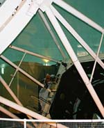
Image credit: ULTRACAM
Although there are numerous telescopes – both large and small – examining the night sky at any one time, the heavens are so vast and so densely populated with all manner of exotic objects that it is extremely easy to overlook a significant random event. Fortunately, a new generation of scientific instruments is now enabling UK astronomers to prepare for the unexpected and become leaders in so-called “Time Domain Astrophysics”.

Exciting new observations of many different, time-variable celestial objects, ranging from black hole X-ray binaries to flare stars and Saturn’s moon Titan will be presented at a Royal Astronomical Society Specialist Discussion Meeting on Friday, 13 February (details below). The meeting will also feature presentations on several ground-breaking UK instruments which make these observations possible.

The Universe around us is constantly changing. Sometimes, the map of the heavens is rewritten by sudden, violent events such as gamma ray bursts (GRBs) and supernovae. Sometimes, a wandering near-Earth asteroid or a gravitational lensing event makes its unpredictable appearance. Most frequently, a star will undergo a modest fluctuation in optical brightness or energy output.

Observing such apparitions and variations can unlock the secrets of a wide variety of the most intriguing and important astronomical objects. Unfortunately, it has proved surprisingly difficult to undertake the type of observations that are required using conventional telescopes and their instruments to solve many outstanding puzzles.

In order to understand these types of phenomena, it is necessary to conduct long term monitoring programmes or to be able to react within minutes to chance discoveries made by other observatories or spacecraft.

“A new generation of facilities, designed and built in the UK, is poised to give the nation’s astronomers a world-leading position in what is dubbed the ‘Time Domain’,” said Professor Mike Bode of Liverpool John Moores University, co-organiser with Professor Phil Charles (Southampton University) of the Royal Astronomical Society meeting about the latest technological breakthroughs in observational astronomy.

This new generation includes the “ULTRACAM” high speed camera, which is being used on various front-rank telescopes around the world. A collaboration between Sheffield and Warwick Universities and the Astronomy Technology Centre, Edinburgh, ULTRACAM can observe changes in brightness lasting only a few thousandths of a second. It has been used to explore the environments of objects as diverse as the atmosphere of Saturn’s smog-shrouded moon, Titan, to the last gasps of gas spiralling into black holes.

Another pioneering instrument is “Super WASP”, a novel telescope comprising effectively five wide-angle cameras. Led by astronomers from a consortium of UK universities, including Queens Belfast, Cambridge, Leicester, Open, and St Andrews, as well as the Isaac Newton Group on La Palma in the Canary Islands, the first Super WASP began operations on La Palma in November 2003.

With its very wide field of view, the telescope can image at any one time an area of sky equivalent to around 1,000 times that of the full Moon. In this way, it is able to observe hundreds of thousands of stars per night, looking for changes in brightness, and discovering new objects. In particular, Super WASP will play a key role in the search for planets in other star systems as they cross the face of their parent star and the flashes of light that may accompany the most dramatic, and enigmatic, explosions since the Big Bang – the so-called Gamma Ray Bursters. In the course of its work, Super WASP will also discover countless asteroids in our own Solar System.

The third of the new facilities is the Liverpool Telescope (LT) on La Palma, pioneering the next-generation robotic telescopes that is being built in Birkenhead by Telescope Technologies Ltd. With its 2m (6.6ft) diameter main mirror, which makes it the largest robotic telescope dedicated to research ever built, the LT started science operations in January 2004. It is owned and operated as a “space probe on the ground” by Liverpool John Moores University (JMU), and supported by funding from JMU, the Particle Physics and Astronomy Research Council, the European Union, the Higher Education Funding Council and the generous benefaction of Mr Aldham Robarts.

Although only operational for just under a month, the LT has already observed a wide range of objects from comets and asteroids, through exploding stars (novae and supernovae) to the variations in light of the centres of active galaxies where it is thought that supermassive black holes may be lurking.

The RAS meeting will also be presented with a vision of the future in which a network of giant robotic telescopes like the LT would be sited around the globe. This robotic telescope network (“RoboNet”) would act as a single, fast-reacting telescope, able to observe objects anywhere on the sky at any time and to follow them 24 hours a day if necessary.

Taking advantage of developments in internet technology, the network will be automatically and intelligently controlled by software developed by the e-STAR project (a collaboration between Exeter University and JMU). e-STAR links the telescopes via “intelligent agents” directly to archives and databases, so that follow-up observations of objects that are seen to vary can automatically be undertaken without human intervention.

Plans are already being considered for a prototype RoboNet based around the LT and its (primarily educational) clones, the Faulkes Telescopes, in Hawaii and Australia. This would lead next to the establishment of a dedicated network in the southern hemisphere searching for planets around other stars. The REX (the Robotic Exo-planet discovery network) project, led by the University of St Andrews, holds out the best prospects for the detection of Earth-like planets around other stars prior to the launch of vastly more expensive space-based observatories in the next decade.

Original Source: RAS News Release

Ozone Destroying Molecule Found

Image credit: NASA
Using measurements from a NASA aircraft flying over the Arctic, Harvard University scientists have made the first observations of a molecule that researchers have long theorized plays a key role in destroying stratospheric ozone, chlorine peroxide.

Analysis of these measurements was conducted using a computer simulation of atmospheric chemistry developed by scientists at NASA’s Jet Propulsion Laboratory (JPL), Pasadena, Calif.

The common name atmospheric scientists use for the molecule is “chlorine monoxide dimer” since it is made up of two identical chlorine-based molecules of chlorine monoxide, bonded together. The dimer has been created and detected in the laboratory; in the atmosphere it is thought to exist only in the particularly cold stratosphere over Polar Regions when chlorine monoxide levels are relatively high.

“We knew, from observations dating from 1987, that the high ozone loss was linked with high levels of chlorine monoxide, but we had never actually detected the chlorine peroxide before,” said Harvard scientist and lead author of the paper, Rick Stimpfle.

The atmospheric abundance of chlorine peroxide was quantified using a novel arrangement of an ultraviolet, resonance fluorescence-detection instrument that had previously been used to quantify levels of chlorine monoxide in the Antarctic and Arctic stratosphere.

We’ve observed chlorine monoxide in the Arctic and Antarctic for years and from that inferred that this dimer molecule must exist and it must exist in large quantities, but until now we had never been able to see it,” said Ross Salawitch, a co-author on the paper and a researcher at JPL.

Chlorine monoxide and its dimer originate primarily from halocarbons, molecules created by humans for industrial uses like refrigeration. Use of halocarbons has been banned by the Montreal Protocol, but they persist in the atmosphere for decades. “Most of the chlorine in the stratosphere continues to come from human-induced sources,” Stimpfle added.

Chlorine peroxide triggers ozone destruction when the molecule absorbs sunlight and breaks into two chlorine atoms and an oxygen molecule. Free chlorine atoms are highly reactive with ozone molecules, thereby breaking them up, and reducing ozone. Within the process of breaking down ozone, chlorine peroxide forms again, restarting the process of ozone destruction.

“You are now back to where you started with respect to the chlorine peroxide molecule. But in the process you have converted two ozone molecules into three oxygen molecules. This is the definition of ozone loss,” Stimpfle concluded.

“Direct measurements of chlorine peroxide enable us to better quantify ozone loss processes that occur in the polar winter stratosphere,” said Mike Kurylo, NASA Upper Atmosphere Research Program manager, NASA Headquarters, Washington.

“By integrating our knowledge about chemistry over the polar regions, which we get from aircraft-based in situ measurements, with the global pictures of ozone and other atmospheric molecules, which we get from research satellites, NASA can improve the models that scientists use to forecast the future evolution of ozone amounts and how they will respond to the decreasing atmospheric levels of halocarbons, resulting from the implementation of the Montreal Protocol,” Kurylo added.

These results were acquired during a joint U.S.-European science mission, the Stratospheric Aerosol and Gas Experiment III Ozone Loss and Validation Experiment/Third European Stratospheric Experiment on Ozone 2000. The mission was conducted in Kiruna, Sweden, from November 1999 to March 2000.

During the campaign, scientists used computer models for stratospheric meteorology and chemistry to direct the ER-2 aircraft to the regions of the atmosphere where chlorine peroxide was expected to be present. The flexibility of the ER-2 enabled these interesting regions of the atmosphere to be sampled.

Original Source: NASA News Release

Both Rovers on the Move

Image credit: NASA/JPL
NASA’s Spirit rover has begun making some of its own driving decisions while its twin, Opportunity, is presenting scientists with decisions to make about studying small spheres embedded in bedrock, like berries in a muffin.

Both rovers are on the move. Late Sunday, Spirit drove about 6.4 meters (21 feet), passing right over the rock called “Adirondack,” where it had finished examining the rock’s interior revealed by successfully grinding away the surface. The drive tested the rover’s autonomous navigation ability for the first time on Mars.

“We’ve entered a new phase of the mission,” said Dr. Mark Maimone, rover mobility software engineer at NASA’s Jet Propulsion Laboratory, Pasadena, Calif. When the rover is navigating itself, it gets a command telling it where to end up, and it evaluates the terrain with stereo imaging to choose the best way to get there. It must avoid any obstacles it identifies. This capability is expected to enable longer daily drives than depending on step-by-step navigation commands from Earth. Tonight, Spirit will be commanded to drive farther on a northeastward course toward a crater nicknamed “Bonneville.”

Over the weekend, Spirit drilled the first artificial hole in a rock on Mars. Its rock abrasion tool ground the surface off Adirondack in a patch 45.5 millimeters (1.8 inches) in diameter and 2.65 millimeters (0.1 inch) deep. Examination of the freshly exposed interior with the rover?s microscopic imager and other instruments confirmed that the rock is volcanic basalt.

Opportunity drove about 4 meters (13 feet) today. It moved to a second point in a counterclockwise survey of a rock outcrop called “Opportunity Ledge” along the inner wall of the rover’s landing-site crater. Pictures taken at the first point in that survey reveal gray spherules, or small spheres, within the layered rocks and also loose on the ground nearby.

NASA now knows the location of Opportunity’s landing site crater, which is 22 meters (72 feet) in diameter. Radio signals gave a preliminary location less than an hour after landing, and additional information from communications with NASA’s Mars Odyssey orbiter soon narrowed the estimate, said JPL’s Tim McElrath, deputy chief of the navigation team.

As Opportunity neared the ground, winds changed its course from eastbound to northbound, according to analysis of data recorded during the landing. “It’s as if the crater were attracting us somehow,” said JPL’s Dr. Andrew Johnson, engineer for a system that estimated the spacecraft’s horizontal motion during the landing. The spacecraft bounced 26 times and rolled about 200 meters (about 220 yards) before coming to rest inside the crater, whose outcrop represents a bonanza for geologists on the mission.

JPL geologist Dr. Tim Parker was able to correlate a few features on the horizon above the crater rim with features identified by Mars orbiters, and JPL imaging scientist Dr. Justin Maki identified the spacecraft’s jettisoned backshell and parachute in another Opportunity image showing the outlying plains.

As a clincher, a new image from Mars Global Surveyor’s camera shows the Opportunity lander as a bright feature in the crater. A dark feature near the lander may be the rover. “I won’t know if it’s really the rover until I take another picture after the rover moves,” said Dr. Michael Malin of Malin Space Science Systems, San Diego. He is a member of the rovers’ science team and principal investigator for the camera on Mars Global Surveyor.

Opportunity’s crater is at 1.95 degrees south latitude and 354.47 degrees east longitude, the opposite side of the planet from Spirit’s landing site at 14.57 degrees south latitude and 175.47 degrees east longitude.

The first outcrop rock Opportunity examined up close is finely-layered, buff-colored and in the process of being eroded by windblown sand. “Embedded in it like blueberries in a muffin are these little spherical grains,” said Dr. Steve Squyres of Cornell University, Ithaca, N.Y., principal investigator for the rovers’ scientific instruments. Microscopic images show the gray spheres in various stages of being released from the rock.

“This is wild looking stuff,” Squyres said. “The rock is being eroded away and these spherical grains are dropping out.” The spheres may have formed when molten rock was sprayed into the air by a volcano or a meteor impact. Or, they may be concretions, or accumulated material, formed by minerals coming out of solution as water diffused through rock, he said.

The main task for both rovers in coming weeks and months is to explore the areas around their landing sites for evidence in rocks and soils about whether those areas ever had environments that were watery and possibly suitable for sustaining life.

JPL, a division of the California Institute of Technology in Pasadena, manages the Mars Exploration Rover project for NASA’s Office of Space Science, Washington, D.C. Images and additional information about the project are available from JPL at http://marsrovers.jpl.nasa.gov and from Cornell University at http://athena.cornell.edu.

Original Source: NASA/JPL News Release

NASA Switches Around Upcoming Station Crews

Image credit: NASA
NASA and its International Partners have assigned new crews to fly to the International Space Station this year. As Expedition 9, NASA astronaut Edward Michael “Mike” Fincke and Russian cosmonaut Gennady Padalka will be the next crew to live aboard the complex. NASA astronaut Leroy Chiao and Russian cosmonaut Salizhan S. Sharipov will serve as Expedition 10.

Fincke and Padalka are set for launch April 18 on a six-month mission. Padalka will serve as Expedition 9 commander and Soyuz commander, and Fincke will be the NASA Space Station science officer and flight engineer. They have been training together as a Space Station crew since March 2002.

Chiao and Sharipov will serve as backup for Expedition 9 and as the prime crew for Expedition 10. They’re scheduled to launch to the Space Station in October. Chiao will serve as the expedition commander and NASA science officer, and Sharipov will serve as Soyuz commander and flight engineer. Astronaut William S. McArthur Jr. and cosmonaut Valery I. Tokarev will serve as the Expedition 10 backup crew.

Russia proposed the new assignment to International Space Station partners through the Multilateral Crew Operations Panel (MCOP). The MCOP agreed to the exchange this week. The decision is still subject to internal review by each partner agency, and NASA anticipates that process to be completed soon.

In November 2003, McArthur and cosmonaut Tokarev were named as Expedition 9 commander and flight engineer.

In mid-January, astronaut Chiao was named as the Expedition 9 commander due to a temporary medical issue related to McArthur’s qualification for that long-duration flight.

Following Chiao’s assignment to fly with Tokarev, NASA and its partners continued to evaluate available crew resources for upcoming flights and decided it was optimal to keep teams together. Since Fincke and Padalka had trained together for years, as had Chiao and Sharipov, the partners made the decision to modify the crew assignments.

“As we’ve continued to evaluate the best use of crew training and resources, we altered our plans to accommodate a change in the Expedition 9 and 10 crews,” Chief Astronaut Kent Rominger said. “Fortunately, the partnership has a pool of highly qualified crew members available, which gives us the flexibility to deal with unexpected circumstances. After a very thorough evaluation by our partners, I’m confident that these assignments make the very best use of our crew resources and skills and will ensure the flights’ full success.”

European Space Agency Astronaut Andre Kuipers will also launch aboard the Soyuz with Fincke and Padalka in April. Kuipers will spend about a week aboard the Station conducting scientific experiments under a commercial agreement between the European Space Agency and Russia. Kuipers will return to Earth with Expedition 8 crewmembers Mike Foale and Alexander Kaleri.

Fincke, a U.S. Air Force lieutenant colonel, is a native of Emsworth, Pa. He will be making his first space flight. Fincke has trained as a backup Station crewmember for two previous missions, Expeditions 4 and 5.

Padalka also has trained as a backup Station crewmember with Fincke for Expedition 4. Padalka will be making his second space flight, having completed 198 days aboard the Russian Mir Space Station in February 1999.

Biographies of Chiao and Sharipov can be found online at:

http://www.jsc.nasa.gov/Bios/

For more information about NASA on the Internet, visit:

http://www.nasa.gov

Original Source: NASA News Release

Canada Developing New Polar Satellite

Image credit: CSA
Canada will transform the future of space-based data delivery and lead cutting-edge scientific research about space weather with the launch of its first multi-purpose satellite mission, today announced Stephen Owen, Minister of Public Works and Government Services, on behalf of Lucienne Robillard, Industry Minister and Minister responsible for Canada Economic Development for Quebec Regions and the Canadian Space Agency.

Called CASSIOPE, this mission will require the building of an innovative satellite platform adaptable for a wide range of assignments, including science, technology, Earth observation, geological exploration and high capacity information delivery. MacDonald, Dettwiler and Associates (MDA) of Richmond, B.C., the prime contractor for CASSIOPE, will lead a Canadian industrial team to develop both the space and ground infrastructure and will operate the spacecraft.

“This mission is a vivid example of the strong economy the Government of Canada is striving to achieve for the 21st century, an economy with exciting applications on Earth and in space. This economy will provide well-paying and meaningful work for Canadians,” said Minister Robillard.

“The CASSIOPE mission demonstrates the compounding value of public-private sector partnership in driving leading-edge technologies and science in support of Canadian priorities,” said Minister Owen. “CASSIOPE will enhance the Canadian space industry’s leadership in information delivery from space and showcase our capacity to design innovative small and micro-satellites. It will also contribute to Canada’s longstanding expertise in atmospheric science.”

The Government of Canada is investing more than $140 million in the development of key technologies and stands to derive a substantial return on its investment if these technologies result in commercial success. The Canadian Space Agency (CSA) is providing $63 million and Technology Partnerships Canada (TPC) $77.2 million.

“Our investment in the design of these new space satellites will increase Canadian knowledge and expertise, diversify our space industry and enhance the timely delivery of Canadian payloads on a more frequent basis,” said CSA President Marc Garneau.

Scheduled for launch in 2007, CASSIOPE will initiate the pilot-phase of a new information delivery service called Cascade that will allow very large amounts of information to be delivered to decision-makers anywhere in the world. Future missions could provide a groundbreaking commercial digital package delivery service, creating a veritable Courier-in-the-Sky to customers ranging from resource exploration companies to trade markets.

CASSIOPE will also include an innovative scientific probe carrying a suite of eight scientific instruments, called ePOP, developed by a scientific team led by the University of Calgary. This $10.3 million CSA-funded payload will collect new data and details on space storms in the upper atmosphere and their potentially devastating impacts on radio communications, GPS navigation, and other space-based technologies.

Original Source: CSA News Release

Black Holes Can Be Ejected From Galaxies

Image credit: Hubble
When black holes collide, look out! An enormous burst of gravitational radiation results as they violently merge into one massive black hole. The ?kick? that occurs during the collision could knock the black hole clear out of its galaxy.

A new study describes the consequences of such an intergalactic collision.

Astrophysicist David Merritt, professor at Rochester Institute of Technology, and co-authors Milos Milosavljevic (Caltech), Marc Favata (Cornell University), Scott Hughes (Massachusetts Institute of Technology) and Daniel Holz (University of Chicago) explore the consequences of kicks induced by gravitational waves in their article, ?Consequences of Gravitational Radiation Recoil,? recently submitted to the Astrophysical Journal and posted online at http://arXiv.org/abs/astro-ph/0402057.

Virtually all galaxies are believed to contain supermassive black holes at their centers. According to current theory, galaxies grow through mergers with other galaxies. When two galaxies merge, their central black holes form a binary system and revolve around each other, eventually coalescing into a single black hole. The coalescence is driven by the emission of gravitational radiation, as predicted by Einstein?s theory of relativity.

Merritt and his colleagues determined how fast a black hole has to move to completely escape a galaxy?s gravitational field. They found that larger and brighter galaxies have stronger gravitational fields and would require a bigger kick to eject a black hole than the smaller systems. Likewise, less forceful impacts could jar the black hole out of its home at the center of a galaxy, only to later rebound back into position.

The kicks also call into question theories that would grow supermassive black holes from hierarchical mergers of smaller black holes, starting in the early universe. ?The reason is that galaxies were smaller long ago, and the kicks would easily have removed the black holes from them,? Merritt says.

According to Merritt and his co-authors, it is more likely that supermassive black holes attained most of their mass through the accretion of gas and that mergers with other black holes only took place after the galaxies had reached roughly their current sizes.

?We know that supermassive black holes exist at the centers of giant galaxies like our own Milky Way,? says Merritt. ?But as far as we know, the smaller stellar systems do not have any black holes. Perhaps they used to, but they were kicked out.?

The kick?a consequence of Einstein?s relativity equations?occurs because gravitational waves emitted during the final plunge are anisotropic, producing recoil. The effect is maximized when one black hole is appreciably larger than the other one.

While astrophysicists have been aware of this phenomenon since the 1960s, until now no one has had the analytical tools necessary to accurately calculate the size of the effect. The first accurate calculation of the size of the kicks was reported in a companion paper by Favata, Hughes and Holz, which also appears online at http://arXiv.org.

Merritt notes that there is no clear observational evidence that the kicks have taken place. He contends that the best chance of finding direct evidence would be locating a black hole shortly after the kick occurs, perhaps in a galaxy that has recently undergone a merger with another galaxy.

?You would see an off-center black hole that hasn?t quite made its way back to the center yet,? he says. ?Even though the probability of observing this is low, now that astronomers know what to look for, I wouldn?t be surprised if someone finds one eventually.?

Original Source: RIT News Release

Opportunity Gets Rolling

Image credit: NASA/JPL
NASA’s Opportunity rover drove about 3.5 meters (11 feet) early Thursday toward a rock outcrop in the wall of a small crater on Mars, and mission controllers plan to send it the rest of the way to the outcrop late Thursday.

Opportunity’s twin, Spirit, successfully reformatted its flash memory on Wednesday. Flash is a type of rewritable memory used in many electronic devices, such as digital cameras, to retain information even while power is off. Problems with the flash memory interfered with Spirit’s operations from Jan. 22 until this week. Engineers prescribed the reformatting to prevent recurrence of the problem.

On Thursday, Spirit’s main assignment is to brush off an area on the rock nicknamed “Adirondack” to prepare for a dust-free examination of its surface. On Friday, controllers at NASA’s Jet Propulsion Laboratory, Pasadena, Calif., plan to have Spirit grind off a small patch of Adirondack?s outer surface and inspect the rock’s interior. Spirit may start driving over the weekend toward a crater about 250 meters (about 270 yards) to the northeast.

For Opportunity, halfway around Mars from Spirit, controllers changed plans Thursday morning. They postponed a trenching operation until the rover gets to an area of its landing-site crater where the soil has a higher concentration of large- grain hematite. That mineral holds high interest because it usually forms under wet conditions. The main science goal for both rovers is to find geological clues about past environmental conditions at the landing sites, especially about whether conditions were ever watery and possibly suitable for sustaining life.

Instead of trenching, Opportunity will be commanded after it next wakes up to drive about 1.5 meters (about 5 feet) farther, possibly to within arm’s reach of one of the rocks in the exposed outcrop.

Before it began driving on Wednesday, Opportunity finished using its alpha particle X-ray spectrometer for the first time. This spectrometer, which assesses what chemical elements are present, took readings on an area of soil that the rover had previously examined with its microscope.

Each martian day, or “sol,” lasts about 40 minutes longer than an Earth day. Spirit begins its 34rd sol on Mars at 3:22 a.m. Thursday, Pacific Standard Time. Opportunity begins its 14th sol on Mars at 3:43 p.m. Friday, PST.

JPL, a division of the California Institute of Technology in Pasadena, manages the Mars Exploration Rover project for NASA’s Office of Space Science, Washington, D.C. Images and additional information about the project are available from JPL at http://marsrovers.jpl.nasa.gov and from Cornell University, Ithaca, N.Y., at http://athena.cornell.edu.

Original Source: NASA/JPL News Release