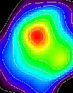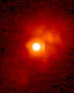
Image credit: NASA/JPL
NASA’s Stardust spacecraft took this photograph of its target, Comet Wild 2, while it was still 25 million kilometers away. The spacecraft is on track to reach the comet on January 2, 2004 when it will pass only 300 km away and capture particles of its tail to return to Earth for analysis – the best photographs are still to come. Mission planners will use these early images to help fine-tune Startdust’s trajectory to give it the closest possible approach to Wild 2’s centre.
Forty-nine days before its historic rendezvous with a comet, NASA’s Stardust spacecraft successfully photographed its quarry, comet Wild 2 (pronounced Vilt-2), from 25 million kilometers (15.5 million miles) away. The image, the first of many comet portraits it will take over the next four weeks, will aid Stardust?s navigators and scientists as they plot their final trajectory toward a Jan. 2, 2004 flyby and collection of samples from Wild 2.
?Christmas came early this year,? said Project Manager Tom Duxbury at NASA?s Jet Propulsion Laboratory, Pasadena, Calif. ?Our job is to aim a 5 meter (16 foot) long spacecraft at a 5.4 kilometer (3.3 mile) wide comet that is closing on it at six times the speed of a bullet. We plan to ?miss the comet? by all of 300 kilometers (188 miles), and all this will be happening 389 million kilometers (242 million miles) away from home. By finding the comet as early and as far away as we did, the complexity of our operations leading up to encounter just dropped drastically.?
The ball of dirty ice and rock, about as big as three Brooklyn Bridges laid end-to-end, was detected on November 13 by the spacecraft?s optical navigation camera on the very first attempt. The set of images was stored in Stardust?s onboard computer and downloaded the next day where mission navigator Dr. Shyam Bhaskaran processed them and noticed a white blob of light bisecting the base of a triangle made by three stars Stardust uses for deep space navigation.
?When I first looked at the picture I didn?t believe it,? said Bhaskaran. ?We were not expecting to observe the comet for at least another two weeks. But there it was, very close to where we thought it would be.?
The Wild 2 sighting was verified on November 18 using the second set of optical navigation images downloaded from Stardust. To make this detection, the spacecraft?s camera saw stars as dim as 11th visual magnitude, more than 1,500 times dimmer than a human can see on a clear night.
The early detection of Wild 2 provides mission navigators critical information on the comet?s position and orbital path. Future optical navigation images will allow them to do more fine-tuning. In turn, these new orbital plots will be used to plan the spacecraft?s approach trajectory correction maneuver. Stardust?s first such maneuver is planned for December 3.
Unlike other orbiting bodies, the paths of comets cannot be precisely predicted because their orbits about the Sun are not solely determined by gravity. The escape of gas, dust and rock from comets provides a “rocket effect” that causes them to stray from a predictable orbital path. The actual orbital path cannot be precisely determined from Earth-based telescopes because the comet is shrouded in a cloud of escaping gas and dust. What is seen from Earth is not the actual 5.4 kilometer (3.3 mile) wide body composed of rock and ice, but the cloud of debris and gas that envelops it.
?With these images we anticipate we will flyby comet Wild 2 at an altitude of 300 kilometers, give or take about 16 kilometers,? added Bhaskaran. ?Without them, we wouldn?t be able to safely get any closer to the comet than several thousand kilometers.?
Stardust will return to Earth in Jan. 2006 to make a soft landing at the U.S. Air Force Utah Test and Training Range. Its sample return capsule, holding microscopic particles of comet and interstellar dust, will be taken to the planetary material curatorial facility at NASA’s Johnson Space Center, Houston, where the samples will be carefully stored and examined.
Stardust?s cometary and interstellar dust samples will help provide answers to fundamental questions about the origins of the solar system. More information on the Stardust mission is available at http://stardust.jpl.nasa.gov .
Stardust, a part of NASA’s Discovery Program of low-cost, highly focused science missions, was built by Lockheed Martin Astronautics and Operations, Denver, Colo., and is managed by JPL for NASA’s Office of Space Science, Washington, D.C. JPL is a division of the California Institute of Technology in Pasadena. The principal investigator is astronomy professor Donald E. Brownlee of the University of Washington in Seattle.
Original Source: NASA/JPL News Release