Opportunity is in a Small Crater

Image credit: NASA/JPL
A small impact crater on Mars is the new home for NASA’s Opportunity rover, and a larger crater lies nearby. Scientists value such crater locations as a way to see what’s beneath the surface without needing to dig.

Encouraging developments continued for Opportunity’s twin, Spirit, too. Engineers have determined that Spirit’s flash memory hardware is functional, strengthening a theory that Spirit’s main problem is in software that controls file management of the memory. “I think we’ve got a patient that’s well on the way to recovery,” said Mars Exploration Rover Project Manager Pete Theisinger at NASA’s Jet Propulsion Laboratory, Pasadena, Calif.

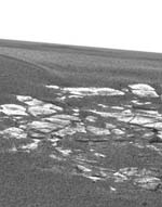
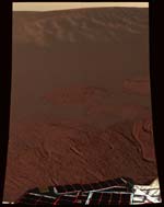
Opportunity returned the first pictures of its landing site early today, about four hours after reaching Mars. The pictures indicate that the spacecraft sits in a shallow crater about 20 meters (66 feet) across.

“We have scored a 300-million mile interplanetary hole in one,” said Dr. Steve Squyres of Cornell University, Ithaca, N.Y., principal investigator for the science instruments on both rovers.

NASA selected Opportunity’s general landing area within a region called Meridiani Planum because of extensive deposits of a mineral called crystalline hematite, which usually forms in the presence of liquid water. Scientists had hoped for a specific landing site where they could examine both the surface layer that’s rich in hematite and an underlying geological feature of light-colored layered rock. The small crater appears to have exposures of both, with soil that could be the hematite unit and an exposed outcropping of the lighter rock layer.

“If it got any better, I couldn’t stand it,” said Dr. Doug Ming, rover science team member from NASA Johnson Space Center, Houston. With the instruments on the rover and just the rocks and soil within the small crater, Opportunity should be allow scientists to determine which of several theories about the region’s past environment is right, he said. Those theories include that the hematite may have formed in a long-lasting lake or in a volcanic environment.

An even bigger crater, which could provide access to deeper layers for more clues to the past, lies nearby. Images taken by a camera on the bottom of the lander during Opportunity’s final descent show a crater about 150 meters (about 500 feet) across likely to be within about one kilometer or half mile of the landing site, said Dr. Andrew Johnson of JPL. He is an engineer for the descent imaging system that calculated the spacecraft’s horizontal motion during its final seconds of flight. The system determined that sideways motion was small, so Opportunity’s computer decided not to fire the lateral rockets carried specifically for slowing that motion.

Squyres presented an outline for Opportunity’s potential activities in coming weeks and months. After driving off the lander, the rover will first examine the soil right next to the lander, then drive to the outcrop of layered-looking rocks and spend considerable time examining it. Then the rover may climb out of the small crater, take a look around, and head for the bigger crater.

But first, Opportunity will spend more than a week — perhaps two — getting ready to drive off the lander, if all goes well. Engineering data from Opportunity returned in relays via NASA’s Mars Odyssey orbiter early this morning and at midday indicate the spacecraft is in excellent health, said JPL’s Arthur Amador, mission manager. The rover will try its first direct-to-Earth communications this evening.

The main task for both rovers in coming months is to explore the areas around their landing sites for evidence in rocks and soils about whether those areas ever had environments that were watery and possibly suitable for sustaining life.

JPL, a division of the California Institute of Technology, Pasadena, manages the Mars Exploration Rover project for NASA’s Office of Space Science, Washington, D.C. Additional information about the project is available from JPL at http://marsrovers.jpl.nasa.gov and from Cornell University, Ithaca, N.Y., at http://athena.cornell.edu.

Original Source: NASA/JPL News Release

Engineers Restore Communications With Spirit

Image credit: NASA/JPL
Hours before NASA’s Opportunity rover will reach Mars, engineers have found a way to communicate reliably with its twin, Spirit, and to get Spirit’s computer out of a cycle of rebooting many times a day.

Spirit’s responses to commands sent this morning confirm a theory developed overnight that the problem is related to the rover’s two “flash” memories or software controlling those memories.

“The rover has been upgraded from critical to serious,” said Mars Exploration Rover Project Manager Peter Theisinger at NASA’s Jet Propulsion Laboratory, Pasadena, Calif. Significant work is still ahead for restoring Spirit, he predicted.

Opportunity is on course for landing in the Meridiani Planum region of Mars. The center of an ellipse covering the area where the spacecraft has a 99 percent chance of landing is just 11 kilometers (7 miles) from the target point. That point was selected months ago. Mission managers chose not to use an option for making a final adjustment to the flight path. Previously, the third and fifth out of five scheduled maneuvers were skipped as unnecessary. ” We managed to target Opportunity to the desired atmospheric entry point, which will bring us to the target landing site, in only three maneuvers,” said JPL’s Dr. Louis D’Amario, navigation team chief for the rovers.

Opportunity will reach Mars at 05:05 Sunday, Universal Time (12:05 a.m. Sunday EST or 9:05 p.m. Saturday PST).

From the time Opportunity hits the top of Mars? atmosphere at about 5.4 kilometers per second (12,000 miles per hour) to the time it hits the surface 6 minutes later, then bounces, the rover will be going through the riskiest part of its mission. Based on analysis of Spirit’s descent and on weather reports about the atmosphere above Meridiani Planum, mission controllers have decided to program Opportunity to open its parachute slightly earlier than Spirit did.

Mars is more than 10 percent farther from Earth than it was when Spirit landed. That means radio signals from Opportunity during its descent and after rolling to a stop have a lower chance of being detected on Earth. About four hours after the landing, news from the spacecraft may arrive by relay from NASA’s Mars Odyssey orbiter. However, that will depend on Opportunity finishing critical activities, such as opening the lander petals and unfolding the rover’s solar panels, before Odyssey flies overhead.

Spirit has 256 megabytes of flash memory, a type commonly used on gear such as digital cameras for holding data even when the power is off. Engineers confirmed this morning that Spirit’s recent symptoms are related to the flash memory when they commanded the rover to boot up and utilize its random-access memory instead of flash memory. The rover then obeyed commands about communicating and going into sleep mode. Spirit communicated successfully at 120 bits per second for nearly an hour.

“We have a vehicle that is stable in power and thermal, and we have a working hypothesis we have confirmed,” Theisinger said. By commanding Spirit each morning into a mode that avoids using flash memory, engineers plan to get it to communicate at a higher data rate, to diagnose the root cause of the problem and develop ways to restore as much functioning as possible.

The work on restoring Spirit is not expected to slow the steps in getting Opportunity ready to roll off its lander platform if Opportunity lands safely. For Spirit, those steps took 12 days.

The rovers’ main task is to explore their landing sites for evidence in the rocks and soil about whether the sites’ past environments were ever watery and possibly suitable for sustaining life.

JPL, a division of the California Institute of Technology in Pasadena, manages the Mars Exploration Rover project for NASA’s Office of Space Science, Washington. Images and additional information about the project are available from JPL at http://marsrovers.jpl.nasa.gov and from Cornell University, Ithaca, N.Y., at http://athena.cornell.edu.

Original Source: NASA/JPL News Release

Opportunity Joins Spirit on Mars

Image credit: NASA/JPL

NASA’s Opportunity rover successfully landed on the surface of Mars early Sunday morning, giving the agency two successful landings this month. The spacecraft landed in a region of Mars called Meridiani Planum which is on the opposite side of the planet from Gusev Crater. Initial estimates placed the rover about 24 km down range from the centre of the target area, but well within the regions of hematite which could be an indication of past water. Unlike Spirit, Opportunity landed on its side and righted itself when it opened the petals of its lander. Opportunity’s airbags aren’t blocking the exit ramp, so there won’t be a problem when the rover rolls out onto the Martian surface.

NASA’s second Mars Exploration Rover successfully sent signals to Earth during its bouncy landing and after it came to rest on one of the three side petals of its four-sided lander.

Mission engineers at NASA’s Jet Propulsion Laboratory, Pasadena, Calif., received the first signal from Opportunity on the ground at 9:05 p.m. Pacific Standard Time Saturday via the NASA Deep Space Network, which was listening with antennas in California and Australia.

“We’re on Mars, everybody!” JPL’s Rob Manning, manager for development of the landing system, announced to the cheering flight team.

NASA Administrator Sean O’Keefe said at a subsequent press briefing, “This was a tremendous testament to how NASA, when really focused on an objective, can put every ounce of effort, energy, emotion and talent to an important task. This team is the best in the world, no doubt about it.”

Opportunity landed in a region called Meridiani Planum, halfway around the planet from the Gusev Crater site where its twin rover, Spirit, landed three weeks ago. Earlier today, mission managers reported progress in understanding and dealing with communications and computer problems on Spirit.

“In the last 48 hours, we’ve been on a roller coaster,” said Dr. Ed Weiler, NASA associate administrator for space science. “We resurrected one rover and saw the birth of another.”

JPL’s Pete Theisinger, project manager for the rovers, said, “We are two for two. Here we are tonight with Spirit on a path to recovery and with Opportunity on Mars.”

By initial estimates, Opportunity landed about 24 kilometers (15 miles) down range from the center of the target landing area. That is well within an outcropping of a mineral called gray hematite, which usually forms in the presence of water. “We’re going to have a good place to do science,” said JPL’s Richard Cook, deputy project manager for the rovers.

Once it pushed itself upright by opening the petals of the lander, Opportunity was expected to be facing east.

The main task for both rovers in coming months is to explore the areas around their landing sites for evidence in rocks and soils about whether those areas ever had environments that were watery and possibly suitable for sustaining life.

JPL, a division of the California Institute of Technology in Pasadena, manages the Mars Exploration Rover project for NASA’s Office of Space Science, Washington. Images and additional information about the project are available from JPL at http://marsrovers.jpl.nasa.gov and from Cornell University, Ithaca, N.Y., at http://athena.cornell.edu .

Original Source: NASA/JPL News Release

Engineers Struggle to Reestablish Link to Spirit

Image credit: NASA/JPL

NASA engineers have been working overtime to reestablish communications with the Spirit rover after it mysteriously stopped talking to mission control on Wednesday just before it executed an experiment to grind a few millimeters into a rock. They did receive a reassuring confirmation on Thursday that Spirit was receiving transmissions from Earth; although, it hasn’t sent any data back yet. The engineers aren’t sure what caused the problem, but since they did get that confirmation, it’s probably not in the power system, radio, transmitter or some software. A very slow communications link was established on Friday morning, but it’s still unclear exactly what’s wrong or if it’s repairable.

NASA’s Spirit rover communicated with Earth in a signal detected by NASA’s Deep Space Network antenna complex near Madrid, Spain, at 12:34 Universal Time (4:34 a.m. PST) this morning.

The transmissions came during a communication window about 90 minutes after Spirit woke up for the morning on Mars. The signal lasted for 10 minutes at a data rate of 10 bits per second.

Mission controllers at NASA’s Jet Propulsion Laboratory, Pasadena, Calif., plan to send commands to Spirit seeking additional data from the spacecraft during the subsequent few hours.

JPL, a division of the California Institute of Technology, Pasadena, manages the Mars Exploration Rover project for NASA’s Office of Space Science, Washington, D.C. Additional information about the project is available from JPL at http://marsrovers.jpl.nasa.gov and from Cornell University, Ithaca, N.Y., at http://athena.cornell.edu.

Original Source: NASA/JPL News Release
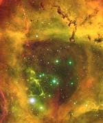
Stellar Nursary in the Rosette Nebula

Image credit: NOAO

A Chinese and US astronomer have discovered a young star at the heart of the Rosette Nebula that is ejecting a complex jet of material with knots and bow shocks. Normally these stars are hidden from the view of optical telescopes by the surrounding nebula, but severe ultraviolet radiation from nearby massive stars has cleared out the area. This gives astronomers have a rare opportunity to study how a young star like this forms. The Rosette Nebula is located 1,500 light-years away in the constellation of Monoceros.

A duo of Chinese and American astronomers have discovered a young star in the fierce environs of the Rosette Nebula that is ejecting a complex jet of material riddled with knots and bow shocks.

Stripped of its normally opaque surroundings by the intense ultraviolet radiation produced by nearby massive stars, this young stellar object is likely one of the last of its generation in this region of space. Its tenuous state of existence exposes the limitations that young stars?and perhaps even sub-stellar objects such as brown dwarfs and large planets?face in attempting to form in such a violent environment.

A close-up image from this study of the young star, and a striking, newly reprocessed wide-field image of the colorful Rosette Nebula, are available above.

?Most young stars are embedded in very dense molecular clouds, which makes our view of the early stages of star formation normally impossible with optical telescopes,? says Travis Rector of the University of Alaska Anchorage, co-author of a paper on the young stellar object (YSO) in the December 2003 issue of Astrophysical Journal Letters. ?This is one of only a few cases where a protostar is visible, making it a valuable discovery that will be studied in detail.?

Optical images of the jet taken at the WIYN 0.9-meter telescope at the National Science Foundation?s Kitt Peak National Observatory in Arizona show a highly-collimated jet, now known as Rosette HH1, stretching for more than 8,000 astronomical units (1 AU = 150 million kilometers). It contains a prominent knot and hints of others, which can be interpreted as ?bullets? of material being ejected from the rapidly rotating YSO at hypersonic velocities on the order of 2,500 kilometers per second. Bow shocks on the other side of the YSO suggest the existence of a degenerated counterjet extending in the opposite direction.

These interpretations of the jet were bolstered by optical spectroscopy of the jet system taken by co-author Jin Zeng Li of the Chinese Academy of Sciences in Beijing using the 2.16-meter telescope of the National Astronomical Observatories of China.

?If it is indeed a counterjet, it may be the only existing observational evidence of how bipolar jets evolve into monopoles, or at least highly asymmetric jets,? according to Jin Zeng Li. ?This suggests that this infant star has been starved of material as its accretion disk is evaporated, leaving a very low-mass star. In some cases, this process might result in an isolated brown dwarf or planetary mass object, offering a potential evolutionary solution for such lone objects that have been spotted in the Orion Nebula and other nearby hotspots in the Milky Way.?

Located an estimated 1,500 light-years from Earth in the constellation Monoceros, the Rosette Nebula is a spectacular region of ionized hydrogen excavated by the strong stellar winds from hot O- and B-type stars in the center of the young open cluster NGC 2244. It is a region of on-going star formation with an age of about three million years.

Kitt Peak National Observatory is part of the National Optical Astronomy Observatory, Tucson, Ariz., which is operated by the Association of Universities for Research in Astronomy (AURA), Inc., under a cooperative agreement with the National Science Foundation.

Original Source: NOAO News Release

First Data from Mars Express

Image credit: ESA

The European Space Agency has gathered a mountain of new data from the Mars Express orbiter, which shows the Red Planet in unprecedented resolution – over the course of the last few weeks it’s gathered more than 100 GB of data. Its photographs show details as fine as sediments left on the bottom of river valleys and dust blowing over the rim of craters. The spacecraft is also detecting water being lost from the Martian atmosphere for the first time. Unfortunately, Mars Express still has yet to detect the British-built Beagle 2 lander, which went missing on December 25, 2003.

Mars Express, ESA?s first mission to Mars, will reach its final orbit on 28 January. It has already been producing stunning results since its first instrument was switched on, on 5 January. The significance of the first data was emphasised by the scientists at a European press conference today at ESA?s Space Operations Centre, Darmstadt, Germany.

“I did not expect to be able to gather together – just one month after the Mars Orbit Insertion of 25 December ? so many happy scientists eager to present their first results”, said Professor David Southwood, ESA Director of Science. One of the main targets of the Mars Express mission is to discover the presence of water in one of its chemical states. Through the initial mapping of the South polar cap on 18 January, OMEGA, the combined camera and infrared spectrometer, has already revealed the presence of water ice and carbon dioxide ice.

This information was confirmed by the PFS, a new high-resolution spectrometer of unprecedented accuracy. The first PFS data also show that the carbon oxide distribution is different in the northern and southern hemispheres of Mars.

The MaRS instrument, a sophisticated radio transmitter and receiver, emitted a first signal successfully on 21 January that was received on Earth through a 70- metre antenna in Australia after it was reflected and scattered from the surface of Mars. This new measurement technique allows the detection of the chemical composition of the Mars atmosphere, ionosphere and surface.

ASPERA, a plasma and energetic neutral atoms analyser, is aiming to answer the fundamental question of whether the solar wind erosion led to the present lack of water on Mars. The preliminary results show a difference in the characteristics between the impact of the solar wind area and the measurement made in the tail of Mars. Another exciting experiment was run by the SPICAM instrument (an ultraviolet and infrared spectrometer) during the first star occultation ever made at Mars. It has simultaneously measured the distribution of the ozone and water vapour, which has never been done before, revealing that there is more water vapour where there is less ozone.

ESA also presented astonishing pictures produced with the High Resolution Stereo Camera (HRSC). They represent the outcome of 1.87 million km2 of Martian surface coverage, and about 100 gigabytes of processed data. This camera was also able to make the longest swath (up to 4000 km) and largest area in combination with high resolution ever taken in the exploration of the Solar System.

This made it possible to create an impressive picture 24 metres long by 1.3 metres high, which was carried through the conference room at the end of the press event by a group of 10-year-old children.

Mrs Edelgard Bulmahn, German Minister for Research and Education, who is also chair of the ESA Council at Ministerial level, said at the press conference: “Europe can be proud of this mission: Mars Express is an enormous success for the European Space Programme.”

Original Source: ESA News Release

New Hubble Photos of Uranus and Neptune

Image credit: Hubble

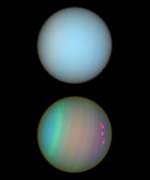
New photographs from the Hubble Space Telescope show details of the atmospheres on Uranus and Neptune. The photos were taken using Hubble’s Imaging Spectrograph and Advanced Camera for Surveys in August 2003. Both planets have bands of clouds and haze lined up with the planets’ equators. Astronomers use different kinds of filters to reveal different kinds of gasses in the clouds, and even their altitudes above the planets.

Atmospheric features on Uranus and Neptune are revealed in images taken with the Space Telescope Imaging Spectrograph and the Advanced Camera for Surveys aboard NASA’s Hubble Space Telescope. The observations were taken in August 2003.

The top row reveals Uranus and Neptune in natural colors, showing the planets as they would appear if we could see them through a telescope. The images are made of exposures taken with filters sensitive to red, green, and blue light. In the bottom images, astronomers used different color filters to detect features we can’t see. The photographs demonstrate that, by using certain types of color filters, astronomers can extract more information about a celestial object than our eyes normally can see.

At first glance, the top row of images makes the planets appear like twins. But the bottom row reveals that Uranus and Neptune are two different worlds. Uranus’s rotational axis, for example, is tilted almost 90 degrees to Neptune’s axis. The south poles of Uranus and Neptune are at the left and bottom, respectively. Both are tilted slightly toward Earth. Uranus also displays more contrast between both hemispheres. This may be caused by its extreme seasons.

Both planets display a banding structure of clouds and hazes aligned parallel to the equator. Additionally, a few discrete cloud features appear bright orange or red. The color is due to methane absorption in the red part of the spectrum. Methane is third in abundance in the atmospheres of Uranus and Neptune after hydrogen and helium, which are both transparent. Colors in the bands correspond to variations in the altitude and thickness of hazes and clouds. The colors allow scientists to measure the altitudes of clouds from far away.

Original Source: Hubble News Release

Amateur Spots Close Passing Asteroid

Image credit: UA

A volunteer analyzing data gathered by the University of Arizona’s Spacewatch program has discovered an 18 x 36 metre asteroid that will miss the Earth by only 2 million kilometres today. Asteroid 2004 BV18 is no risk; even if it did hit the Earth, it wouldn’t do much more than cause a bright flash in the atmosphere. The asteroid was spotted by amateur astronomer Stu Megan, who was analyzing Spacewatch data through the Internet, and demonstrates how volunteers can help the search for near Earth asteroids.

A volunteer who analyzes online images for the University of Arizona Spacewatch program has discovered a 60-to-120-foot diameter asteroid that will miss Earth by about 1.2 million miles tomorrow, Jan. 22.

While the asteroid is no cause for alarm, its discovery marks a milestone in a new project that relies on volunteers to spot fast-moving objects, or FMOs, in Spacewatch images.

Even if asteroid 2004 BV18 hit Earth head-on, it would only create a bright flash of light in the upper atmosphere, and possibly streaks of light as asteroid fragments heat to incandescence while they rocket across the sky. “In other words, a bright meteoric display known as a bolide,” said Robert S. McMillan, who directs UA’s Spacewatch.

The asteroid appeared in images taken by Spacewatch astronomer Miwa Block with the 0.9-meter telescope at 1:49 UT on Jan. 19, which is 6:49 p.m. MST on Jan. 18. Volunteer Stu Megan reviewed the images on the Internet, and spotted the asteroid’s light trail. Megan is part of a Web-based program that Spacewatch made public last October through a grant from the Paul G. Allen Charitable Foundation.

“It’s hard to explain the excitement when you find a fast-moving asteroid,” Megan said in an E-mail message.

Megan is semi-retired from a 35-year career in information technology and an amateur astronomer who is interested in finding potentially hazardous asteroids. A resident of Tucson, he has reviewed close to 6,500 Spacewatch images during the past three months.

“When I saw (this light trail), it just sat there screaming at me. It was very, very bright and a perfect length. I knew it could be nothing else.”

Three observatories made follow-up observations of the asteroid, so scientists at the Minor Planet Center could compute its orbit. The Minor Planet Center gave Asteroid 2004 BV18 its provisional designation yesterday. (A provisional designation is one that’s adopted until the asteroid’s orbit is known well enough that astronomers won’t lose it.) The center also published the discovery and follow-up studies in the Minor Planet Electronic Circular yesterday.

The asteroid is classified as an “Apollo” asteroid because it is on average slightly farther from the sun than the Earth is, but its modest orbital eccentricity causes it to occasionally cross Earth’s orbit.

At the time Megan discovered the asteroid, it was six times farther from Earth than the Earth is from the moon. Seen from Earth, it appeared to move across the sky at about 6.5 degrees per day, or about the diameter of 13 full moons. At closest approach tomorrow, it will be five times the distance between Earth and the moon.

Spacewatch operates 1.8-meter and 0.9-meter CCD-equipped telescopes on Kitt Peak, about 45 miles southwest of Tucson, Ariz. The project studies solar system dynamics through the movements of asteroids and comets. Spacewatch also finds potential targets for interplanetary spacecraft missions and hunts for objects that might pose a threat to Earth.

The 0.9-meter telescope typically takes two-minute-long exposures, and objects closest to Earth move so quickly through the telescope’s field of view that they trace a line on the sky image. Objects orbiting farther from Earth appear to move more slowly, just as an airplane flying at 40,000 feet appears to move slower than it does at takeoff.

Computer software has a hard time detecting FMO light trails because they vary greatly in length and direction.

Human observers are still much better than computers at finding FMOs in Spacewatch images. But the work is too time intensive for on-duty Spacewatch observers. So the astronomers have turned to 30 volunteers for help. FMO project volunteers are based in the United States, Germany, and Finland.

They would gladly accept more.

The only requirements are interest, sharp eyes, and access to a computer when astronomers are operating Spacewatch telescopes on Kitt Peak. More details on how to volunteer for the FMO Project are on the Web at FMO Project.

“Our reviewers are students, people with full-time jobs, retired ? they run the gamut,” McMillan said. “While our most dedicated volunteers tend to be members of the amateur astronomy community or at least have a strong interest and knowledge of astronomy, we have members who have just begun to climb the learning curve.

“We hope that our Website helps fuel curiosity and participation in science in general, as well as provide a productive outlet for those eager to apply their computer skills,” McMillan said.

McMillan’s Spacewatch team protects the privacy of its volunteers, releasing volunteers’ names only to the Minor Planet Center when discoveries are to be published.

Astronomers want to study small asteroids to know how many there are, their spin rates and surface properties, McMillan said.

Spin rate tells observers if the asteroid is a single solid piece or a loose aggregate of rocks.

The distribution of asteroid sizes tells scientists about the effects of asteroid collisions during the lifetime of the solar system.

The smallest asteroids are free of regoliths, the blanket of loose dust or dirt that obscures the bare rock surfaces of larger asteroids. And the smallest asteroids are useful for studying non-gravitational forces that work on very long time scales, such as the Yarkovsky Effect, a phenomenon where heat propels objects through space.

The Spacewatch Project was begun in 1980 at the UA Lunar and Planetary Laboratory. More information about Spacewatch can be found on the Web at Spacewatch.

Original Source: UA News Release

New Earth Measurement Data Released

Image credit: NASA

NASA has released detailed topographical data of Europe and Asia that was gathered by the space shuttle as part of the 10-day Shuttle Radar Topography Mission (SRTM) in February 2000 that mapped 80% of the Earth’s surface. This data represents 40-percent of the data collected during the mission. North and South American data has already been made available, and the remainder should be completed by 2004. This precise 3-D mapping information is being used in many applications, including studying natural disasters, planning development, and aircraft navigation.

Marco Polo. Alexander the Great. They were some of history’s most prolific explorers, each trekking across sweeping stretches of Europe and Asia in their lifetimes. But these greats of world history had nothing on you, thanks to a new topographic data set from NASA and the National Geospatial-Intelligence Agency (NGA). You now can explore the vast reaches of most of Europe, Asia and numerous islands in the Indian and Pacific Oceans, from the comfort of home, without breaking a sweat.

Gathered in just 10 days by NASA’s Shuttle Radar Topography Mission (SRTM) in February 2000, the new digital elevation data set showcases some of Earth’s most diverse, mysterious and extreme topography. Much of it previously had been very poorly mapped due to persistent cloud cover or inaccessible terrain. The new data being released comprise more than one-third of the entire SRTM data set.

The new images are available on the JPL Planetary Photojournal at:

http://photojournal.jpl.nasa.gov/catalog/PIA03398
http://photojournal.jpl.nasa.gov/catalog/PIA03399
http://photojournal.jpl.nasa.gov/catalog/PIA04950
http://photojournal.jpl.nasa.gov/catalog/PIA04951

“People around the world will benefit from the release of the SRTM Europe and Asia topographic data sets because they greatly extend our knowledge of this immense region that also is home to most of Earth’s citizens,” said Dr. John LaBrecque, manager, Solid Earth and Natural Hazards Program, NASA Headquarters, Washington.

“The shape of Earth’s surface affects nearly every natural process and human endeavor. Precise, uniform, 3-D elevation data are needed for a wide range of applications from studying earthquakes, volcanism, floods and other natural hazards, to planning development, managing precious water resources, and insuring the safety of aircraft navigation,” LaBrecque noted.

“Releasing the Eurasia SRTM data provides geospatial data users with a remarkably consistent Earth-elevation surface. This enhances our global knowledge, provides a baseline for any future comparisons, and delivers accuracy and integrity unparalleled in any other global-elevation model of the Earth,” said NGA’s Technical Executive Roberta Lenczowski. “This SRTM data represents 40 percent of the data collected during the mission that covered roughly 80 percent of the landmass of the Earth. The cooperative effort between NASA and NGA, fusing science objectives with national security requirements, benefits all,” Lenczowski added.

The area covered in the current data-release stretches eastward from the British Isles and the Iberian Peninsula in the west, across the Alps and Carpathian Mountains, as well as the Northern European Plain, to the Ural and Caucasus Mountains bordering Asia. The Asian coverage includes a great variety of landforms, including the Tibetan Plateau, Tarim Basin, Mongolian Plateau and the mountains surrounding Lake Baikal, the world’s deepest lake. Mt. Everest in the Himalayas, at 8,848 meters (29,029 feet) is the world’s highest mountain. From India’s Deccan Plateau, to Southeast Asia, coastal China, and Korea, various landforms place constraints on land-use planning during periods of population growth. Volcanoes in the East Indies, the Philippines, Japan and the Kamchatka Peninsula form the western part of the “Ring of Fire” around the Pacific Ocean.

Previous releases from the mission covered North and South America. Forthcoming releases in 2004 will include Africa-Arabia and Australia, as well as an “islands” release for those islands not included in the continental data-releases. Together, these data-releases constitute the world’s first high-resolution, near-global elevation model. The resolution of these data for Europe and Asia is three arc seconds (1/1,200 of a degree of latitude and longitude), which is about 90 meters (295 feet).

The SRTM mission is a cooperative project of NASA, NGA and the German and Italian space agencies. NASA’s Jet Propulsion Laboratory, Pasadena, Calif., processed the data into research-quality digital elevation data. The National Geospatial-Intelligence Agency is providing additional processing to develop mapping products. The U.S. Geological Survey Earth Resources Observation Systems Data Center in Sioux Falls, S.D., provides final archiving and distribution of the SRTM data products.

Information about SRTM is available at:

http://www.jpl.nasa.gov/srtm

More information about NASA is at:

http://www.jpl.nasa.gov/srtm

Original Source: NASA News Release

Distance to Pleiades Calculated

Image credit: NOAO

Astronomers from NASA’s Jet Propulsion Laboratory have measured the distance to the Pleiades star cluster to greatest precision ever. After a decade’s worth of interferometric measurements, the team found that the star cluster is between 434 and 446 light years from Earth. This is important because the European Hipparcos satellite previously measured a distance to the cluster that would have contradicted theoretical models of the life cycles of stars. This new measurement shows that Hipparcos was incorrect, and the established theory still holds.

The cluster of stars known as the Pleiades is one of the most recognizable objects in the night sky, and for millennia has been celebrated in literature and legend. Now, a group of astronomers has obtained a highly accurate distance to one of the stars of the Pleiades known since antiquity as Atlas. The new results will be useful in the longstanding effort to improve the cosmic distance scale, and to conduct research on the stellar life-cycle.

In the January 22 issue of the journal Nature, astronomers from the California Institute of Technology and NASA?s Jet Propulsion Laboratory, both in Pasadena, Calif., report the best-ever distance to the double-star Atlas. The star, along with “wife” Pleione and their daughters, the “seven sisters,” are the principal stars of the Pleiades that are visible to the unaided eye, although there are actually thousands of stars in the cluster. Atlas, according to the team’s decade of careful interferometric measurements, is somewhere between 434 and 446 light-years from Earth.

The range of distance to the Pleiades cluster may seem somewhat imprecise, but in fact is accurate by astronomical standards. The traditional method of measuring distance is by noting the precise position of a star and then measuring its slight change in position when Earth itself has moved to the other side of the sun. This approach can also be used to find distance on Earth: If you carefully record the position of a tree an unknown distance away, move a specific distance to your side, and measure how far the tree has apparently “moved,” then it’s possible to calculate the actual distance to the tree by using trigonometry.

However, this procedure gives only a rough distance estimate to even the nearest stars, due to the gigantic distances involved and the subtle changes in stellar position that must be measured.

The team’s new measurement settles a controversy that arose when the European satellite Hipparcos provided a much shorter distance measurement to the Pleiades than expected and contradicted theoretical models of the life cycles of stars.

This contradiction was due to the physical laws of luminosity and its relationship to distance. A 100-watt light bulb one mile away looks exactly as bright as a 25- watt light bulb half a mile away. So to figure out the wattage of a distant light bulb, we have to know how far away it is. Similarly, to figure out the “wattage” (luminosity) of observed stars, we have to measure how far away they are. Theoretical models of the internal structure and nuclear reactions of stars of known mass also predict their luminosities. So the theory and measurements can be compared.

However, the Hipparcos data provided a distance lower than that assumed from the theoretical models, thereby suggesting either that the Hipparcos distance measurements themselves were off, or else that there was something wrong with the models of the life cycles of stars. The new results show that the Hipparcos data was in error, and that the models of stellar evolution are indeed sound.

The new results come from careful observation of the orbit of Atlas and its companion — a binary relationship that wasn’t conclusively demonstrated until 1974 and certainly was unknown to ancient watchers of the sky. Using data from the Mount Wilson stellar interferometer, next to the historic Mount Wilson Observatory, and the Palomar Testbed Interferometer at Caltech’s Palomar Observatory near San Diego, the team determined a precise orbit of the binary.

Interferometry is an advanced technique that allows, among other things, for the “splitting” of two bodies so far away that they normally appear as a single blur, even in the biggest telescopes. Knowing the orbital period and combining it with orbital mechanics allowed the team to infer the distance between the two bodies, and with this information, to calculate the distance of the binary to Earth.

“For many months I had a hard time believing our distance estimate was 10 percent larger than that published by the Hipparcos team,” said the lead author, Xiao Pei Pan of JPL. “Finally, after intensive rechecking, I became confident of our result.”

Coauthor Shrinivas Kulkarni, a Caltech astronomy and planetary science professor, said, “Our distance estimate shows that all is well in the heavens. Stellar models used by astronomers are vindicated by our value.”

“Interferometry is a young technique in astronomy and our result paves the way for wonderful returns from the Keck interferometer and the anticipated Space Interferometry Mission that is expected to be launched in 2009,” said coauthor Michael Shao of JPL, prinicipal investigator for that planned mission, and for the Keck Interferometer, which links the two 10-meter telescopes at the Keck Observatory in Hawaii. The Palomar Testbed Interferometer was designed and built by a team of researchers from JPL led by Mark Colavita and Shao. It served as an engineering testbed for the Keck Interferometer.

Original Source: NASA/JPL News Release