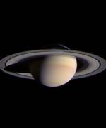
Learning How Planets Form

Astronomers are hoping NASA’s new Space Infrared Telescope Facility will answer more questions about how disks of gas and dust turn into a planetary system. The problem is that the disk seems to get obscured by material during the middle stages of its formation. SIRTF should be able to peer through the obscuring material to reveal this missing link of planetary formation. At some point in the system’s evolution, mass is eaten up by the star, ejected into space or transformed into planets – SIRTF may help to solve this riddle.

Just as anthropologists sought “the missing link” between apes and humans, astronomers are embarking on a quest for a missing link in planetary evolution. Only instead of dusty fields and worn shovels, their laboratory is the universe, and their tool of choice is NASA?s new Space Infrared Telescope Facility.

Launched on Aug.25, NASA’s fourth and final Great Observatory will soon set its high-tech infrared eyes on, among other celestial objects, the dusty discs surrounding stars where planets are born.

While other ground- and space-based telescopes have spied these swirling “circumstellar” discs, both young and old, they have missed middle-aged discs for various reasons. The Space Infrared Telescope Facility’s unprecedented sensitivity and resolution will allow it to fill in this gap ? and in the process answer fundamental questions regarding how planets, including those resembling Earth, may form.

“With the Space Infrared Telescope Facility, we anticipate seeing many planetary discs at all stages of development,” says Dr. Karl Stapelfeldt of JPL, a scientist with the mission. “By studying how they change over time, we may be able to determine what conditions favor planet formation.”

Circumstellar discs are a natural step in the evolution of stars. Stars begin life as dense cocoons of gas and dust, then as pressure and gravity kick in, they begin to coalesce, and a flat ring of gas and dust takes shape around them. As stars continue to age, they suck material from this disc into their core. Eventually, a state of equilibrium is reached, leaving a more mature star encircled by a stable disc of debris.

It is around this time, about 10 million years into the lifetime of the star, that astronomers believe planets arise. Dust particles in the discs are thought to collide to form larger bodies, which ultimately sweep out gaps in the discs, much like those lying between the rings of Saturn.

“You can think of planets as wrecking balls that either clear away debris or gather it up as if it were mud,” says Dr. George Rieke, principal investigator on one of the three science instruments onboard the observatory.

Infrared telescopes can sense the glow of the cosmic dust that makes up these discs; however, they cannot detect planets directly. Planets have less surface area than their equivalent in dust grains and thus give off less infrared light. This is the same reason coffee is ground up before brewing: the larger combined surface area of the coffee grains results in a more robust pot of coffee.

Past observations of circumstellar discs generally fall into two categories: young, opaque discs (called protoplanetary discs) with more than enough mass to match our own solar system’s planetary bodies; or older, transparent discs (called debris discs) with masses equal to a few moons, and doughnut-like holes at their center. Middle-aged discs linking these two developmental stages have gone undetected.

One of the questions astronomers hope to address with the Space Infrared Telescope Facility is: What happened to all the mass observed in the younger discs? Somewhere in their evolution, mass is either eaten up by the star, ejected by the star ? or transformed into planets that lie in the doughnut holes of the discs. By analyzing the composition and structure of the “missing link” discs, astronomers hope to solve this riddle, and better understand how planetary systems like our own evolved.

Original Source: NASA News Release

Sea Launch… On Land?

Image credit: Sea Launch

Until now, Sea Launch was known for its ocean-based launch platform which is towed out to the Pacific Ocean to launch rockets from the Earth’s equator, but a new offering will occasionally see the company launching from dry land – in Kazakhstan. Sea Launch will be offering launch services from the Baikonur cosmodrome; the same place that Russia launches its rockets. “Land Launch” will use existing Zenit launch facilities to lift cargos in the 2,500-3,500 kg range to geosyncronous orbits. The first launch is scheduled for October 4th, 2005.

Following the 10th successful Sea Launch mission on Sept. 30, the Sea Launch Board of Directors met and resolved to go forward with plans to offer launch services from the Baikonur Cosmodrome in Kazakhstan, in addition to its sea-based launches at the Equator. The new offering, Land Launch, is based on the collaboration of Sea Launch Company and Space International Services (SIS), of Russia, to meet the launch needs of commercial customers with medium weight satellites.

Optimizing on heritage hardware, systems and expertise, the Land Launch system will use a version of the Sea Launch Zenit-3SL rocket to lift commercial satellites in the 2000-3500 kg range to geosynchronous transfer orbit, and heavier payloads to inclined or lower orbits. A two-stage configuration of the same rocket will also be available for launching heavy payloads, or groups of payloads, to low Earth orbits. Payloads and vehicles will be processed and launched from existing Zenit facilities at the Baikonur launch site.

“Land Launch represents a major opportunity for Sea Launch to expand its role in the commercial space transportation arena,” said Jim Maser, president and general manager of Sea Launch. “We responded to the need for cost-efficiency and schedule assurance in the heavy-lift market. Now, through our Land Launch offering, we are responding to the demand for reliable, single payload capabilities in the medium-weight payload market.”

“All SIS partners look forward to bringing their extensive expertise to this project,” said Igor Alekseev, director, SIS. “With the strong support of the Russian Aviation and Space Agency and the participation of Sea Launch, we are confident that Land Launch will bring an outstanding service to the market.”

With an initial launch capability slated for the 4th Quarter of 2005, Land Launch will use existing Zenit technology and infrastructure, minimizing risk, cost and start-up time. Sea Launch will provide commercial customers with mission management and the Boeing-led quality assurance and hardware acceptance procedures that have contributed to the outstanding reliability of the Sea Launch system. SIS will be responsible for launch operations.

Boeing Launch Services, Inc. (BLS) will manage marketing and sales for the new offering, in a seamless expansion of their current support to Sea Launch customers. Established in 2001, the BLS team represents a family of vehicles to meet every payload lift requirement, from 1,000 kg -13,000 kg. For more information, go to: www.boeing.com/launch

Sea Launch Company, LLC, based in Long Beach, Calif., provides reliable heavy lift launch services to commercial satellite customers. The international partners include Boeing (U.S.), Kvaerner Group (Norway), RSC Energia (Russia) and SDO Yuzhnoye/PO Yuzhmash (Ukraine). Established in 1995, Sea Launch has completed ten successful missions. For more information, visit the Sea Launch website at www.sea-launch.com

Space International Services is a Moscow-based venture, founded by SDO Yuzhnoye/PO Yuzhmash, the Design Bureau of Transport Machinery (KBTM, of Russia), and TseNKI (Center for Ground-based Space Infrastructure, of Russia), under the Russian Space and Aviation Agency.

Original Source: Sea Launch news release

SMART-1 is Doing Well

Image credit: ESA

The European Space Agency’s SMART-1 spacecraft has completed its 50th orbit of the Earth; operating its ion engine for more than 560 hours. The engine can only fire for half of the orbit because the spacecraft needs to raise its orbit until it reaches the Moon. ESA controllers have performed a series of tests on the spacecraft, and almost everything seems to be working perfectly – there’s a minor problem with its star-tracker. The spacecraft is expected to reach the Moon by March 2005, when it will begin mapping surface minerals and ice.

The spacecraft is now completing its 50th orbit and has completed more than 560 hours in space. The main actvity of the last week has been to repeatedly use the electric propulsion engine to gradually alter the spacecraft’s orbit. This is limited to around 15 hours a day based on whether the spacecraft is in eclipse. So far the engine has generated thrust for an accumulated time of about 240 hours.

The electric propulsion engine performance has been periodically monitored by means of telemetry data transmitted by the spacecraft and by radio-tracking at the ground stations. The EP performance has been constantly improving, as expected, during the thrusting phase. During the first firing we measured an underperformance of about 3%, as expected in the early operations of the engine in its first use. Today we have a slight over-performance of about 0.5% which gives us confidence in the excellent conditions of the electric propulsion system.

The electric power provided by the solar arrays is nominal. The expected degradation due to the radiation environment is less severe then the worst case scenario. We can, therefore, assume that we shall be able to thrust at full power for quite some time.

The thermal subsystem is performing very well: all the temperatures are as expected and the heater power consumption is lower than estimated. This is a comfortable situation and gives us confidence that the system will be able to cope well with the long eclipse seasons in the spring of next year.

The communication, data handling and on-board software subsystems have been performing nominally so far. The attitude control subsystem has, in general, been working very well and the controller performance during the thrusting phase has been so smooth and accurate that there has been no need to use the hydrazine thrusters to desaturate the small reaction wheels used as main actuators.

The main area of concern is the star tracker performance. This advanced autonomous star mapper has recently failed to provide good attitude information in a few cases around perigee and eclipse periods. Although the attitude control system can cope with these occasional problems, the spacecraft planned operations are disturbed by these events. The operation team at ESOC is obliged to reschedule the operations to take into account these events. In the meantime the ESTEC project and industry teams are busy trying to find an explanation to these anomalies. Despite this inconvenience the thrusting periods are maintained. More on the subject will be provided in future reports.

Orbital/Trajectory information
The SMART-1 orbit is continuously modified by the effects of the electric propulsion low thrust. The osculating orbital elements are periodically computed by the ESOC specialists. These elements define the so called ‘osculating orbit’ which would be travelled by the spacecraft if at that instant all perturbations, including EP thrust, would cease. So it is an image of the situation at that moment. In reality the path travelled by the spacecraft is a continuous spiral leading from one orbit to another.

In this diagram the GTO, the osculating orbits at launch and at different times are plotted. The large orbit, marked ‘final’, is the one we expect to achieve at the end of the radiation belt escape in about two months.

From the start, the electric propulsion system has managed to increase the semi-major axis of the orbit by 1555 km, increasing the perigee altitude from the original 656 km to 2035 km and the orbital period by more than one hour, from the initial 10 hours 41 minutes to the present 11 hours 42 minutes.

Original Source: ESA News Release

30-Metre Telescope in the Works

Image credit: Caltech

The possibility of a 30-metre telescope moved closer to reality this week when the Gordon and Betty Moore Foundation awarded $17.5 million to fund the detailed design study. Planned for completion in 2012, the Thirty-Metre Telescope will have nine times the light-gathering power of the 10-metre Keck observatory; the largest in the world. With its adaptive optics capacity, it should be able to produce images which are 12 times sharper than the Hubble Space Telescope. The building site hasn?t been chosen yet, but it will probably be in Mexico, Hawaii or Chile.

The dream of a giant optical telescope to improve our understanding of the universe and its origin has moved a step closer to reality today. The Gordon and Betty Moore Foundation awarded $17.5 million to fund a detailed design study of the Thirty-Meter Telescope (TMT). This new grant allows the California Institute of Technology and its partner, the University of California, to proceed with formulating detailed construction plans for the telescope.

An earlier, more modest, study completed in 2002 resulted in a roughed-out concept for a 30-meter-diameter optical and infrared telescope, complete with adaptive optics, which would result in images more than 12 times sharper than those of the Hubble Space Telescope. The TMT– formerly known as the California Extremely Large Telescope–will have nine times the light-gathering ability of one of the 10-meter Keck Telescopes, which are currently the largest in the world.

“Caltech and the University of California will work in close and constant collaboration to achieve the goals of the design effort,” states Richard Ellis, director of optical observatories at Caltech. “We’ve had promising discussions with the Association of Universities for Research in Astronomy and the Association of Canadian Universities for Research in Astronomy, both of whom are considering joining us as major collaborators. Constructing and operating a telescope of this size will be a huge undertaking requiring a large collaborative effort.”

According to Ellis, the Gordon and Betty Moore Foundation’s early funding will provide crucial momentum to carry the project to fruition. “The major goals of the design phase will include an extensive review and optimization of the telescope design, addressing areas of risk, for example by early testing of key components, and staffing a project office in Pasadena.”

With such a telescope, astrophysicists will be able to study the earliest galaxies and the details of their formation as well as to pinpoint the processes which lead to young planetary systems around nearby stars.

“The key new capabilities promised by the Thirty Meter Telescope will include unprecedented angular resolution, necessary to resolve detail in early galaxies and forming planetary systems, and of course the huge collecting area for studying the faintest sources, which are often the most important to understand, but are beyond the reach of current facilities.”” adds Chuck Steidel, professor of astronomy, who chaired a science committee charged with making the case for the proposed facility.

Following the Gordon and Betty Moore Foundation-funded design study, the final phase of the project, not yet funded, will be construction of the observatory at a yet undetermined site in Hawaii, Chile, or Mexico. The end of this phase would mark the beginning of regular astronomical observations, perhaps by 2012.

Ellis says TMT is a natural project for Caltech to undertake, given its decades of experience in constructing, operating, and conducting science with the world’s largest telescopes. Before Caltech and the University of California’s jointly-operated Keck Observatory went on-line in the 1990s, Caltech’s 200-inch Hale Telescope at Palomar Observatory was among the largest optical instruments in the world. Today, 54 years after its first light, the Hale Telescope is still in continuous use as a major research instrument.

“This project takes Caltech’s success in ground-based astronomy to the next level of ambition,” Ellis says. “The TMT will also build logically on the successful demonstration of the segmented primary mirrors of the Keck telescopes, a major innovation at the time but now recognized as the only route to making a primary mirror of this size.”

Caltech is currently in the process of hiring a project manager to lead the technical effort for the TMT.

The Gordon and Betty Moore Foundation was created in November 2000 with a multibillion-dollar contribution from its founders. The mission of the Foundation is to seek and develop outcome-based projects that will improve the quality of life for future generations. The majority of the Foundation’s grant making concerns large-scale initiatives in four general program areas: the environment, higher education, science, and San Francisco Bay Area projects.

Original Source: Caltech News Release

Titan 2 Finally Launches Weather Satellite

Image credit: Lockheed Martin

A Titan II rocket successfully placed a US military weather satellite into orbit on Friday after suffering three years of delays. When the US Airforce decommissioned 14 Titan ICBMs, it contracted Lockheed Martin to refurbish them to launch satellites into orbit ?this was the last of them. The DMSP F16 weather satellite has eight instruments to track clouds, storm systems and hurricanes around the world for weather forecasting.

A Lockheed Martin-built Titan II launch vehicle successfully placed the Defense Meteorological Satellite Program (DMSP) Block 5D-3 spacecraft into orbit this morning for the U.S. Air Force. The Titan II lifted off at 9:17 a.m. Pacific Daylight Time from Space Launch Complex 4West at Vandenberg Air Force Base, Calif. DMSP will be used for strategic and tactical weather prediction to aid the U.S. military in planning operations at sea, on land and in the air.

This launch marked the end of an era for the Lockheed Martin Titan team as the final refurbished intercontinental ballistic missile (ICBM) – dubbed Titan II – flew a perfect mission, capping an overall success record of 100 percent.

“Everyone at Lockheed Martin who has ever been a part of the Titan program watched with pride this morning as we launched another important space asset for our military forces,” said G. Thomas Marsh, executive vice president of Lockheed Martin Space Systems Company. “The Titan II program has been an outstanding example of partnership between the Air Force and Lockheed Martin, and we are very proud to fly the final rocket successfully and round out a perfect Titan II record.”

Titan II ICBMs served as the vanguard of the United States? strategic deterrent for more than two decades. In the late 1960s, 10 Titan IIs also successfully launched astronauts as part of the Gemini program. When the Titan II ICBMs were decommissioned, the U.S. Air Force Space and Missile Systems Center, Los Angeles, Calif., contracted with Lockheed Martin to refurbish 14 for use as space launch vehicles. Today?s mission marked the 13th consecutive successful Titan launch. There are no current plans to launch the 14th vehicle.

DMSP, operated by the National Oceanic and Atmospheric Administration (NOAA), is used for strategic and tactical weather prediction to aid the U.S. military in planning operations at sea, on land and in the air. Equipped with a sophisticated sensor suite that can image visible and infrared cloud cover, the satellite collects specialized meteorological, oceanographic and solar-geophysical information in all weather conditions. The DMSP constellation comprises two spacecraft in near-polar orbits, C3 (command, control and communications), user terminals and weather centers. The most recent launch of a DMSP spacecraft took place on Dec. 12, 1999 from Vandenberg Air Force Base. That launch marked the first of the Block 5D-3 satellites.

The Space and Missile Systems Center at Los Angeles Air Force Base, Calif. manages the DMSP and Titan programs.

Lockheed Martin Space Systems Company is one of the major operating units of Lockheed Martin Corporation. Space Systems designs, develops, tests, manufactures and operates a variety of advanced technology systems for military, civil and commercial customers. Chief products include a full-range of space launch systems, including heavy-lift capability, ground systems, remote sensing and communications satellites for commercial and government customers, advanced space observatories and interplanetary spacecraft, fleet ballistic missiles and missile defense systems.

Headquartered in Bethesda, Md., Lockheed Martin employs about 125,000 people worldwide and is principally engaged in the research, design, development, manufacture and integration of advanced technology systems, products and services. The corporation reported 2002 sales of $26.6 billion.

Original Source: Lockheed Martin News Release

Soyuz Docks with Station

Image credit: NASA

Two days after launching from the Baikonur cosmodrome in Kazakhstan, the Soyuz TMA-3 spacecraft successfully docked with the International Space Station. Astronauts Michael Foale, Alexander Kaleri, and visiting European Agency Astronaut Pedro Duque will briefly join the crew of Expedition 7: Ed Lu and Yuri Malenchenko on the station. Malenchenko, Lu and Duque will leave the station on October 27 so that Expedition 8 can begin their six month mission.

The International Space Station?s newest crew of Expedition 8 Commander Mike Foale and Flight Engineer Alexander Kaleri officially boarded the complex when hatches between its Soyuz spacecraft swung open at 5:19 a.m. CDT ( 1019 GMT, 2:19 p.m. Moscow time). They were joined by visiting researcher, European Space Agency astronaut Pedro Duque.

Greeting them on the station were Expedition 7 Commander Yuri Malenchenko and NASA ISS Science Officer Ed Lu, who are 177 days into their six months in space. The two crews will conduct eight days of joint operations and research before Expedition 7 and Duque return home on October 27.

Among those observing the on orbit arrival of Expedition 8 to the station were NASA Associate Administrator for Space Flight William Readdy and International Space Station Program Manager William Gerstenmaier. Both talked to the five station crew members delivering best wishes for the mission.

The plan for the two crews includes eight days of handover activities and scientific experiments carried out by Duque for Spanish and other European scientists under a commercial contract between ESA and the Russian Aviation and Space Agency.

After lunch, the new crewmembers will receive a safety briefing from Malenchenko and Lu and install a seat liner for Duque in the Soyuz earmarked for landing Oct. 27 (U.S. time) and then begin setting up a host of Duque?s equipment previously launched on Russian Progress resupply spacecraft.

The crews are scheduled to go to bed about 3 p.m. CDT today and wake up at midnight to begin their first full day of joint operations. Expedition 8 officially will take control of Station operations October 27 when Malenchenko, Lu and Duque close the hatches between their returning Soyuz and the station. Foale and Kaleri will remain on board until late April 2004.

Original Source: NASA News Release

What’s Next for China?

With Yang Liwei safely on the ground, China took advantage of their space momentum to highlight their future plans. Officials from the Chinese Space Agency announced today on state television that another Shenzhou flight will take place within one to two years. After that will come a series of flights to master docking spacecraft and spacewalking. And then the Chinese intend to build a space station of their own; nothing as elaborate as Mir or the International Space Station, which will be serviced by Shenzhou.

India Launches Remote Sensing Satellite

Image credit: ISRO

An Indian PSLV rocket blasted off today from the Satish Dhawan Space Center carrying the IRS-P6 remote sensing satellite into an 821 km high polar orbit. The rocket was launched even though the weather was poor with heavy rains ? the wind, however, wasn?t a problem. IRS-P6 is the most advanced remote sensing satellite built by the Indian Space Research Organization (ISRO); it will primarily monitor natural resources, like water, agriculture, and gather land management data.

In its eighth flight conducted from Satish Dhawan Space Centre, (SDSC), SHAR, Sriharikota, today (October 17, 2003), ISRO’s Polar Satellite Launch Vehicle, PSLV-C5, successfully launched the Indian remote sensing satellite, RESOURCESAT-1 (IRS-P6) into a 821km high polar Sun Synchronous Orbit (SSO). The 1,360 kg RESOURCESAT-1 is the most advanced and heaviest remote sensing satellite launched by ISRO so far. PSLV forms an important component of the end to end system created by ISRO for natural resource planning and management.

PSLV-C5 lifted off from SDSC, SHAR, Sriharikota at 10:22 am with the ignition of the core first stage and four strap-on motors. The remaining two strap-on motors of the first stage were ignited at 25 sec after lift-off. After going through the planned flight events including the separation of the ground-lit strap-on motors, separation of air-lit strap-on motors and first stage, ignition of the second stage, separation of the payload fairing after the vehicle had cleared the dense atmosphere, second stage separation, third stage ignition, third stage separation, fourth stage ignition and fourth stage cut-off, RESOUCESAT-1 was systematically injected into orbit 1080 seconds after lift-off.

RESOURCESAT-1 was separated after suitable reorientation of the fourth stage-equipment bay combination to avoid any collision with the satellite. RESOURCESAT-1 has been placed in the polar Sun Synchronous Orbit (SSO) at an altitude of 821 km with an inclination of 98.76 deg with respect to the equator.

About PSLV
It may be noted that PSLV was designed and developed by ISRO to place 1,000 kg class Indian remote sensing satellites into polar Sun-synchronous Orbit (SSO). Since its first successful flight in October 1994, the capability of PSLV has been enhanced from 850 kg to the present 1,400 kg into 820 km Sun Synchronous Orbit. PSLV has also demonstrated multiple satellite launch capability. So far, it has launched seven Indian satellites as well as four small satellites for international customers.

The improvement in the payload capability of PSLV over successive flights has been achieved through several means — increase in the propellant loading of the first stage solid propellant motor and second and fourth stage liquid propellant motors, improvement in the performance of the third stage motor by optimizing motor case and enhanced propellant loading and employing a carbon composite payload adapter. The sequence of firing of the strap-on motors has also been changed from two ground-lit and four air-lit to the present four ground-lit and two air-lit sequence.

In the PSLV-C5, the metallic third stage adapter was replaced by the one built with carbon composites. Also, the liquid propellant second stage was operated at a higher chamber pressure for better performance.

In its present configuration, the 44.4 metre tall, 294 tonne PSLV has four stages using solid and liquid propulsion systems alternately. The first stage is one of the largest solid propellant boosters in the world and carries 138 tonne of Hydroxyl Terminated Poly Butadiene (HTPB) propellant. It has a diameter of 2.8 m. The motor case is made of maraging steel. The booster develops a maximum thrust of about 4,762 kN. Six strap-on motors, four of which are ignited on the ground, augment the first stage thrust. Each of these solid propellant strap-on motors carries nine tonne of solid propellant and produces 645 kN thrust.

The second stage employs indigenously built Vikas engine and carries 41.5 tonne of liquid propellant — UH25 as fuel and Nitrogen tetroxide (N2O4) as oxidiser. It generates a maximum thrust of about 800 kN.

The third stage uses 7.6 tonne of HTPB-based solid propellant and produces a maximum thrust of 246 kN. Its motor case is made of polyaramide fibre. The fourth and the terminal stage of PSLV has a twin engine configuration using liquid propellant. With a propellant loading of 2.5 tonne (Mono-methyl hydrazine and Mixed Oxides of Nitrogen), each of these engines generates a maximum thrust of 7.3 kN.

The 3.2 m diameter metallic bulbous payload fairing of PSLV is of isogrid construction and protects the spacecraft during the atmospheric regime of the flight. PSLV employs a large number of stage auxiliary systems for stage separation, payload fairing separation and jettisoning, etc.

PSLV control system includes: a) First stage; Secondary Injection Thrust Vector Control (SITVC) for pitch and yaw, reaction control thrusters for roll b) Second stage; Engine gimbal for pitch and yaw and, hot gas reaction control motor for roll control c) Third stage; flex nozzle for pitch and yaw and PS-4 RCS for roll control and d) Fourth stage; Engine gimbal for pitch, yaw and roll and, on-off RCS for control during the coast phase.

The inertial navigation system in the equipment bay, which is located on top of the fourth stage, guides the vehicle from lift-off to spacecraft injection into orbit. The vehicle is provided with instrumentation to monitor the vehicle performance during the flight. S-band PCM telemetry and C-band transponders cater to this requirement. The tracking system provides real-time information for flight safety and for preliminary orbit determination once the satellite is injected into orbit.

The Vikram Sarabhai Space Centre (VSSC), Thiruvananthapuram, designed and developed PSLV. The ISRO Inertial Systems Unit (IISU) at Thiruvananthapuram developed the inertial systems for the vehicle. The Liquid Propulsion Systems Centre, also at Thiruvananthapuram, developed the liquid propulsion stages for the second and fourth stages of PSLV as well as reaction control systems. The Satish Dhawan Space Centre (SDSC), SHAR processed the solid motors and carried out launch operations. ISTRAC provided telemetry, tracking and command support.

With seven successive successful launches, PSLV has proved itself as a reliable vehicle for launching Indian remote sensing satellites. Besides, it has been used for launching a geo-synchronous satellite, KALPANA-1. ISRO has proposed to use PSLV for India’s first unmanned mission to moon, Chandrayaan-1.

RESOURCESAT-1 carries three cameras as follows:
* A high resolution Linear Imaging Self Scanner (LISS-4) operating in three spectral bands in the Visible and Near Infrared Region (VNIR) with 5.8 metre spatial resolution and steerable up to + 26 deg across track to obtain stereoscopic imagery and achieve five day revisit capability
* A medium resolution LISS-3 operating in three spectral bands in VNIR and one in Short Wave Infrared (SWIR) band with 23.5 metre spatial resolution
* An Advanced Wide Field Sensor (AWiFS) operating in three spectral bands in VNIR and one band in SWIR with 56 metre spatial resolution.

RESOURCESAT-1 also carries a Solid State Recorder with a capacity of 120 Giga Bits to store the images taken by its cameras which can be read out later to the ground stations.

Soon after its injection into orbit, the solar panels on board RESOURCESAT-1 were deployed automatically to generate the necessary electrical power for the satellite. Further operations like three axis stabilisation are being carried out. The satellite health is being continuously monitored from the Spacecraft Control Centre at Bangalore with the help of ISTRAC network of stations at Bangalore, Lucknow, Mauritius, Bearslake in Russia and Biak in Indonesia. Further operations on the satellite like orbit trimming, checking out the various subsystems and, finally, switching on the cameras will be carried out in the coming days.

With ISRO Satellite Centre (ISAC), Bangalore, as the lead Centre, RESOURCESAT-1 was realised with major contributions from Space Applications Centre (SAC), Ahmedabad, Liquid Propulsion Systems Centre (LPSC) at Bangalore, and ISRO Inertial Systems Unit (IISU), Thiruvananthapuram. ISTRAC is responsible for initial and in-orbit operation of RESOURCESAT-1. The National Remote Sensing Agency ‘s (NRSA) Data Reception Station at Shadnagar near Hyderabad receives the data from RESOURCESAT-1.

Once commissioned, RESOURCESAT-1 will not only continue the services of IRS-1C and IRS-1D, but also enhance the remote sensing services by providing imageries with improved spatial resolution and additional spectral bands.

Original Source: ISRO News Release

Glaciers in Patagonia Melting Faster Then Expected

Image credit: NASA/JPL

New research from NASA shows that glaciers in the Patagonia region of South America are thinning out at an accelerated rate. Researchers compared data from the recent space shuttle topography mission in 2000 against historical surveys from the 1970s and 90s. The Patagonia glaciers are losing mass faster than other icefields, such as those in Alaska, which are five times larger. This different rate of melting is important, because it helps researchers understand some of the factors that could contribute other than just overall global climate change.

The Patagonia Icefields of Chile and Argentina, the largest non-Antarctic ice masses in the Southern Hemisphere, are thinning at an accelerating pace and now account for nearly 10 percent of global sea-level change from mountain glaciers, according to a new study by NASA and Chile’s Centro de Estudios Cientificos.

Researchers Dr. Eric Rignot of NASA’s Jet Propulsion Laboratory, Pasadena, Calif.; Andres Rivera of Universidad de Chile, Santiago, Chile; and Dr. Gino Casassa of Centro de Estudios Cientificos, Valdivia, Chile, compared conventional topographic data from the 1970s and 1990s with data from NASA’s Shuttle Radar Topography Mission, flown in February 2000. Their objective was to measure changes over time in the volumes of the 63 largest glaciers in the region.

Results of the study, published this week in the journal Science, conclude the Patagonia Icefields lost ice at a rate equivalent to a sea level rise of 0.04 millimeters (0.0016 inches) per year during the period 1975 through 2000. This is equal to nine percent of the total annual global sea-level rise from mountain glaciers, according to the 2001 Intergovernmental Panel on Climate Change Scientific Assessment. From 1995 through 2000, however, that rate of ice loss from the icefields more than doubled, to an equivalent sea level rise of 0.1 millimeters (0.004 inches) per year.

In comparison, Alaska’s glaciers, which cover an area five times larger, account for about 30 percent of total annual global sea-level rise from mountain glaciers. So what’s causing the increased Patagonia thinning?

Rignot and his colleagues concluded the answer is climate change, as evidenced by increased air temperatures and decreased precipitation over time. Still, those factors alone are not sufficient to explain the rapid thinning. The rest of the story appears to lie primarily in the unique dynamic response of the region’s glaciers to climate change.

“The Patagonia Icefields are dominated by so-called ‘calving’ glaciers,” Rignot said. “Such glaciers spawn icebergs into the ocean or lakes and have different dynamics from glaciers that end on land and melt at their front ends. Calving glaciers are more sensitive to climate change once pushed out of equilibrium, and make this region the fastest area of glacial retreat on Earth.?

Rignot said the study underscores NASA’s unique contributions to understanding changes in Earth’s cryosphere. “From the unique vantage point of space, the Shuttle Radar Topography Mission provided the first complete topographic coverage of the Patagonia Icefields,” he explained. “Researchers can now access data on this remote Earth region in its totality, allowing them to draw conclusions about the whole system, rather than just focusing on changes on a few glaciers studied from the ground or by aircraft.?

Rignot said scientists are particularly interested in studying how climate interacts with glaciers because it may be a good barometer of how the large ice sheets of Greenland and Antarctica will respond to future climate change. “We know the Antarctic peninsula has been warming for the past four decades, with ice shelves disappearing rapidly and glaciers behind them speeding up and raising sea level,” he noted. “Our Patagonia research is providing unique insights into how these larger ice masses may evolve over time in a warmer climate,” he said.

The Northern Patagonia Icefield in Chile and the Southern Patagonia Icefield in Chile and Argentina, cover 13,000 and 4,200 square kilometers (5,019 and 1,622 square miles), respectively. The region, spanning the Andes mountain range, is sparsely inhabited, with rough terrain and poor weather, restricting ground access by scientists. Precipitation in the region ranges from 2 to 11 meters (6.6 to 36 feet) of water equivalent per year, a snow equivalent of up to 30 meters (98.4 feet) a year. The icefields discharge ice and meltwater to the ocean on the west side and to lakes on the east side, via rapidly flowing glaciers. The fronts of most of these glaciers have been retreating over the past half- century or more.

The study benefited from ground experiments led jointly by Centro de Estudios Cientificos; Universidad de Chile; University of Washington, Seattle; and University of Alaska, Fairbanks, with funding by NASA, Fondecyt (Chilean National Science Foundation) and the National Science Foundation International Program.

The Shuttle Radar Topography Mission is a cooperative project of NASA, the National Imagery and Mapping Agency, and the German and Italian space agencies. Information about the Shuttle Radar Topography Mission is available at: http://www.jpl.nasa.gov/srtm/. The California Institute of Technology in Pasadena manages JPL for NASA.

Original Source: NASA News Release

Four Possible Causes for Contour’s Failure

Image credit: NASA

NASA investigators have come up with four possible reasons why the Comet Nucleus Tour (CONTOUR) mission failed in August 2002. The mission launched in July 2002, and was supposed to visit at least two comets and study their icy nuclei, but something went wrong that caused the spacecraft to disappear from ground tracking stations. The most probably cause of the failure was a structural failure of the spacecraft while its solid rocket motor was firing, but the investigators are also considering a collision with debris, a catastrophic failure of the rocket motor, and loss of the spacecraft?s control systems.

NASA’s Comet Nucleus Tour (CONTOUR) Mishap Investigation Board (MIB) identified four possible causes for the failure of the comet-rendezvous mission launched in July 2002. The Board concluded the probable proximate cause for this accident was structural failure of the spacecraft due to plume heating during the embedded solid-rocket motor burn.

However, the lack of telemetry and observational data, immediately prior to and during the burn, and the lack of recoverable debris, leave open the possibility that one of several other problems could have led to the accident. The alternate possible causes are catastrophic failure of the solid rocket motor; collision with space debris or meteoroids; and loss of dynamic control of the spacecraft.

NASA was not able to re-establish contact with the spacecraft on August 15, 2002, following a propulsive maneuver involving the solid rocket motor. On August 22, 2002, the Associate Administrator for Space Science established the NASA CONTOUR Mishap Investigation Board with Theron Bradley Jr., NASA Chief Engineer, as chair. The purpose of the Board was to examine the processes, data and actions surrounding the events of August 15; to search for proximate and root causes; and develop recommendations that may be applicable to future missions.

Based on various facts and data, the MIB concluded the alternate possible causes were less likely than the identified proximate cause. Nonetheless, in the spirit of constructively improving future mission reliability, the Board drew conclusions, identified lessons learned, and made recommendations based on the broader range of possible causes, according to Bradley.

Launched on July 3, 2002, CONTOUR was intended to encounter at least two comets and perform a variety of investigations and analyses of the comet material. It remained in Earth orbit until August 15, 2002, when an integral Alliant Techsystems STAR? 30BP solid rocket motor was fired to leave orbit and begin the transit to the comet Encke.

CONTOUR was programmed to re-establish telemetry contact with the ground following the burn, however, no signal was received. The mission design did not provide for telemetry coverage during the solid rocket motor burn and no provision was made to optically observe the burn.

Active attempts to contact CONTOUR were unsuccessful. On August 16, 2002, limited ground observations identified what appeared to be three separate objects on slightly divergent trajectories near, but behind, CONTOUR’s expected position. Further attempts to contact CONTOUR were made through December 20, 2002, when NASA and Johns Hopkins University/Applied Physics Laboratory (APL), Laurel, Md., concluded the spacecraft was lost. The project manager at APL oversaw the technical implementation of the project and was responsible for the design, development, test and mission operations.

The MIB established Root Causes and Observations contributing to the failure, and recommendations for each in the Report.

“NASA will apply the lessons from CONTOUR to future missions,” Bradley said. He stated the report represented a lot of tough detective work by the many individuals and organizations involved in the investigation. “The lack of data meant the investigators could leave no stone unturned in their search for possible causes,” he said.

Original Source: NASA News Release