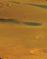
Image credit: ESA
Especially for Valentine’s Day, Envisat picks out a heart from the arid landscape of Africa’s Sahara.
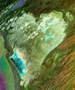
This is a multi-temporal Advanced Synthetic Aperture Radar (ASAR) image of the central coast of Mauritania in West Africa, perched on the edge of the Sahara Desert.
The heart-shaped image seen at the centre of the picture is actually a land feature called the Sebkha Te-n-Dghamcha ? a large depression covering an area about 70 by 50 km across. ‘Sebkha’ is the Arabic for dry lake, and it was indeed once covered by water ? the area’s lowest point is more than three metres below sea level.
Most of the water evaporated, leaving behind layers of salt and other minerals including gypsum ? today supporting a thriving mining industry. What remains are shallow ponds of salty water, visible in the image.
While optical images are based on reflected light, radar images like this one show surface roughness, recording how radar pulses were scattered back from the ground towards a space-based detector.
Radar images are ordinarily in black and white. The colours come from combining three different image acquisitions into a single multi-temporal image, useful for highlighting changes occurring over time.
The first acquisition was on 23 November 2002, matching to red; the second on 23 March 2003, corresponding to green; and the last on 24 April 2003, shown as blue. The areas of whiteness in the final image represent areas of high surface reflectivity unchanged between acquisitions.
The saltpan surface of Sebkha Te-n-Dghamcha returns more radar backscatter than surrounding rock and desert sand. In the same way, the roofs and walls of Mauritania’s capital city Nouakchott reflect radar well, and so show up as the white area on the coast at the base of the image.
The different amounts of colours from each acquisition combine in the final image to form other hues that can be interpreted by experienced image processors ? for example, the magenta tint of the Atlantic Ocean shows it was at its calmest during the March acquisition.
Original Source: ESA News Release