10,000 New Images of Mars

Image credit: NASA/JPL

NASA has released 10,232 new images of the Red Planet taken by the Mars Global Surveyor spacecraft, including wind whipped polar dunes, steep-walled valleys, and boulder-strewn terrain. The images were taken over the course of several months, from August 2002 to February 2003, and they include views all over the planet. This brings the total number of images taken by Surveyor in six years of observation to more than 134,000.

Thousands of newly released portraits of martian landscapes from NASA’s Mars Global Surveyor spacecraft testify to the diversity of ways geological processes have sculpted the surface of our neighboring planet.

Swirling textures that some scientists call “taffy-pull terrain? fill one new image from the plains of southern Mars, for example. Other images reveal details of features such as wind-whipped polar dunes and steep-sided valleys carved by flowing water or lava.

The 10,232 newly released pictures from the Mars Orbiter Camera on Mars Global Surveyor bring the total number of images in the camera’s online gallery to more than 134,000. The new batch is at: http://www.msss.com/mars_images/moc/2003/09/30/.

“Mars just keeps astounding us with its complexity,” said Dr. Ken Edgett, staff scientist for Malin Space Science Systems, San Diego, Calif, which built and operates the Mars Orbiter Camera.

The new group of images was taken between August 2002 and February 2003, then validated and archived by the camera team. It includes many views of north polar terrain, extremely clear-atmosphere views of a deep southern basin named Hellas Planitia, and a variety of martian landforms between the north pole and the southern middle latitudes. The pictures show martian surface details down to the size of a large sport utility vehicle.

Since Mars Global Surveyor began orbiting Mars six years ago, the mission has provided a wealth of information about the planet’s atmosphere and interior, as well at its surface.

Evaluation of landing sites for NASA’s Spirit and Opportunity, two Mars Exploration Rover spacecraft due to land on Mars in January 2004, relied heavily on mineral mapping, detailed imagery and topographic measurements by Global Surveyor.

Additional information about Mars Global Surveyor is available online at: http://mars.jpl.nasa.gov/mgs/.

In addition to semi-annual releases of large collections of archived pictures, the Mars Orbiter Camera team posts a new image daily and recently began soliciting public suggestions for camera targets on Mars. The full gallery is available at: http://www.msss.com/moc_gallery/.

Original Source: NASA News Release

Sea Launch Lofts Galaxy XIII/Horizons-1

Image credit: Boeing

Sea Launch successfully launched Boeing-built Galaxy XIII/Horizons-1 satellite from the equator in the Pacific Ocean early this morning. A Zenit-3SL rocket lifted off from the launch platform at 0403 GMT (12:03am EDT) and carried the dual purpose satellite into orbit. A ground tracking station received signals from the satellite about an hour after launch, indicating that it was functioning normally and in the right trajectory to make its journey to geosynchronous orbit. It will eventually provide a variety of telecommunication services to North America.

Last night, a successful launch orbited Galaxy XIII/Horizons-1, a Boeing 601HP satellite built by Boeing [NYSE:BA] for PanAmSat Corporation, Wilton, Conn., and JSAT Corporation of Japan. The satellite will provide coverage over North America, Central America, Alaska and Hawaii from an orbital slot between the Hawaiian Islands and the U.S. west coast.

The 4,090 kg (8,998 lbs) satellite rocketed to geosynchronous transfer orbit aboard a Zenit-3SL provided by Sea Launch Company, LLC. Lift-off occurred at 9:03 p.m. PDT (4:03 a.m. GMT) from the Sea Launch Odyssey Launch Platform positioned on the equator in the Pacific Ocean. The spacecraft received its first signals at about 10:03 p.m. PDT at a ground station at Fucino, Italy, confirming normal operation.

?Communications satellites have erased the distance between the far corners of the globe,? said Dave Ryan, president of Boeing Satellite Systems International, a wholly owned subsidiary of Boeing. ?Galaxy XIII/Horizons-1 will continue that heritage as it also links the aspirations of PanAmSat and JSAT, who will use it to deliver trans-Pacific communications services. We are very proud to continue our legacy of teamwork with these two very important long time customers.?

Galaxy XIII/Horizons-1 with a final orbit slot at 127 degrees west longitude is the 207th Boeing-built commercial communications satellite launched to date. Forty years ago this year, the Boeing-built Syncom ushered in a revolution as the world?s first geosynchronous communications satellite.

Galaxy XIII/Horizons-1 will support PanAmSat?s domestic cable program distribution services as well as the Horizons international joint venture of PanAmSat and JSAT. The spacecraft will carry a total of 48 active transponders, 24 each in Ku-band and C-band. The Horizons partnership will use the spacecraft’s Ku-band payload, known as Horizons-1, to offer a variety of digital video, Internet and data services. In addition, the Ku-band payload on Galaxy XIII/Horizons-1 will be able to deliver content and services between the United States and Asia, using a teleport in Hawaii.

The C-band portion of the new spacecraft, known as Galaxy XIII, will be operated separately as part of PanAmSat’s Galaxy cable neighborhood, which serves the domestic U.S. cable industry. Galaxy XIII will be used to replace capacity on Galaxy IX, a Boeing 376 model that will move to a new orbital position and continue to provide services.

PanAmSat Corporation (NASDAQ:SPOT) is the premier provider of global video and data broadcasting services via satellite. For more information on PanAmSat, visit the company’s web site at www.panamsat.com. JSAT is a leading satellite operator in the Asia-Pacific region. For more information on JSAT, visit the company’s web site at www.jsat.net.

A unit of The Boeing Company, Boeing Integrated Defense Systems is one of the world’s largest space and defense businesses. Headquartered in St. Louis, Boeing IDS is a $25 billion business that provides systems solutions to its global military, government and commercial customers. It is a leading provider of intelligence, surveillance and reconnaissance; the world’s largest military aircraft manufacturer; the world’s largest satellite manufacturer and a leading provider of space-based communications; the primary systems integrator for U.S. missile defense; NASA’s largest contractor; and a global leader in launch services.

Original Source: Boeing News Release

SMART-1 Fires its Ion Engine

Image credit: ESA

The European Space Agency’s SMART-1 spacecraft passed an important test on Tuesday when it started up its ion engine – the propulsion system that will take it to the Moon. Engineers at the ESA’s control centre sent the spacecraft the command to test fire its engine for an hour, and they didn’t encounter any problems. SMART-1 will use the ion engine to make bigger and bigger orbits around the Earth until it’s caught by the gravity of the Moon. Then it will use the engine to make smaller orbits around the Moon until it’s close enough to begin gathering science data about the surface.

SMART-1’s revolutionary propulsion system was successfully fired at 12:25 UT on 30 September, 2003, in orbit around the Earth.

Engineers at ESOC, the European Space Agency’s control centre in Darmstadt, Germany, sent a command to begin the firing test, which lasted for one hour. This was similar to a trial performed on Earth before SMART-1 was launched.

Several months ago, the ion engine, or Solar Electric Primary Propulsion (SEPP) system, had been placed in a vacuum chamber on the ground and its functions and operation were measured. Now in space and in a true vacuum, the ion engine actually worked better than in the test on ground and has nudged SMART-1 a little closer to the Moon.

This is the first time that Europe flies an electric primary propulsion in space, and also the first European use of this particular type of ion engine, called a ‘Hall-effect’ thruster.

The SEPP consists of a single ion engine fuelled by xenon gas and powered by solar energy. The ion engine will accelerate SMART-1 very gradually to cause the spacecraft to travel in a series of spiralling orbits – each revolution slightly further away from the Earth – towards the Moon. Once captured by the Moon’s gravity, SMART-1 will move into ever-closer orbits of the Moon.

As part of one of the overall mission objectives to test this new SEPP technology, the data will now be analysed to see how much acceleration was achieved and how smoothly the spacecraft travelled. If the ion engine is performing to expectations, ESA engineers will regularly power up the SEPP to send SMART-1 on its way.

Original Source: ESA News Release

Sea Launch Countdown Begins

Image credit: Boeing

The Sea Launch arrived at the equator in the Pacific Ocean on the weekend, and began the 72-hour countdown to the launch of the Galaxy XIII/Horizons-1 satellite on board a three-stage Zenit-3SL rocket. If all goes well, the rocket will lift off on October 1 at 0403 GMT (12:03am EDT) and carry the satellite to a high perigee geosynchronous transfer orbit. Once it reaches its final destination, the satellite will provide data, television, and voice communication services to North America.

The Sea Launch team arrived at the equatorial launch site this weekend and initiated a 72-hour countdown to liftoff of the Galaxy XIII/Horizons-1 mission for PanAmSat Corporation and JSAT Corporation. All systems are proceeding on schedule for the launch, scheduled for Tuesday, September 30, 9:03 pm PDT (4:03:00 GMT, October 1) at the opening of the 39-minute launch window.

The Odyssey Launch Platform and its sister ship, the Sea Launch Commander, arrived at the launch site on Saturday. The marine crew began the process of ballasting the Launch Platform about 65 feet, to launch depth, in preparation for launch operations. The vessels are now stationed alongside each other, frequently connected by a link bridge that enables foot traffic between them. On the day of launch, the platform will be evacuated and all personnel will be stationed on the ship, three miles uprange, throughout launch operations.

Sea Launch?s three-stage Zenit-3SL rocket will loft the 4,090 kg (9,081 lb) Galaxy XIII/Horizons-1 satellite to a high perigee geosynchronous transfer orbit. Following the successfully completed mission, the spacecraft will be located in geostationary orbit at 127 degrees West Longitude. Built by Boeing Satellite Systems in El Segundo, Calif., the 601 HP model spacecraft is designed to offer a variety of digital video, Internet and data services to North America, Central America, Alaska and Hawaii. Horizons-1 is jointly owned by PanAmSat and JSAT, and supports their Horizons venture. It will provide expanded Ku-band services in North America and extended services to Japan and Asia via a Hawaii-based relay station. The C-band payload, Galaxy XIII, which will be operated independently by PanAmSat, will offer the first high-definition neighborhood in the U.S. cable arc.

Sea Launch will provide a live satellite broadcast and simultaneous webcast of the Galaxy XIII/Horizons-1 mission on September 30, beginning at 8:45pm PDT (3:45:00 GMT, October 1). The broadcast, featuring live video from the launch site as well as commentary, may be downlinked from satellite coordinates posted at the following site:
www.boeing.com/nosearch/sealaunch/broadcast.html
Streaming video of the mission will be carried live at:
www.sea-launch.com/current_index_webcast.html

Original Source: Boeing news release

Envisat is Watching the World’s River Levels

Image credit: ESA

The European Space Agency’s demonstrated the capability of its Envisat Earth monitoring satellite to track the water levels of inland lakes and rivers; spots on the Earth that were previously invisible to previous radar altimetry. The Radar Altimeter 2 on board Envisat sends 1800 radar pulses a second from 800 km altitude and then calculates how long they take to return – this tells the device its exact distance to the planet. A team from pored through the raw Envisat data and figured out a way to extract river water levels by spotting specific kinds of radar echos. ESA will release 12 years of river levels for scientists to study.

For over a decade ESA has used satellites to bounce radar pulses off the Earth and precisely measure the height of ocean and land surfaces. But inland lakes and rivers have been effective blind spots for radar altimetry ? at least until now.

Next week ESA previews a new product range called River and Lake Level from Altimetry that provides previously inaccessible information on water levels of major lakes and rivers across the Earth’s surface, derived from Envisat and ERS radar altimeter measurements.

Hydrologists can use this new data to monitor river heights around the planet, assess the impact of global warming and help with water resource management. Inland water bodies are important as key sources of both water and food for the people living round them. They are also often regions of maximum biodiversity and represent early indicators of regional climate change.

A new processing algorithm has been developed to extract rivers and lakes level findings from raw radar altimeter data. The development effort was headed by Professor Philippa Berry of the UK’s De Montfort University: “The new radar altimeter product is a great leap forward for hydrologists. It gives them a new tool to study both the historical changes in water table levels and critically important data to use in forecasting models of water availability, hydroelectric power production, flood and drought events and overall climate changes.”

The Radar Altimeter 2 (RA-2) flown aboard ESA’s Envisat environmental satellite is the improved follow-on to earlier radar altimeters on the ERS-1 and ERS-2 spacecraft. From its 800 km-high polar orbit it sends 1800 separate radar pulses down to Earth per second then records how long their echoes take to return ? timing their journey down to under a nanosecond to calculate the exact distance to the planet below.

Radar altimeters were first flown in space back in the 1970s, aboard NASA’s Skylab and Seasat. These early efforts stayed focused firmly on the oceans, as less-smooth land surfaces returned indecipherable signals. But as the technology improved reliable land height data became available. Envisat’s RA-2 has an innovative ‘four-wheel drive’ tracking system allowing it to maintain radar contract even as the terrain below shifts from ocean to ice or dry land.

But rivers and lakes have proved tougher targets. Large lakes and wide rivers such as the Amazon often returned tantalising ‘wet’ radar signals, but echoes from nearby dry land distorted most such signals.

Believing full-fledged river and lake level monitoring was nevertheless feasible, ESA awarded a contract to De Montfort University to develop a suitable software product, with Lancaster University advising on field hydrology.

The De Montfort University team proceeded by painstakingly combing through many gigabytes of raw data acquired over rivers and lakes, taking note of the type of echo shapes that occurred. They sorted different echo shapes into distinct categories, then created an automated process to recognise these shapes within ‘wet’ signals and eventually extract usable data from them.

“To do this, the shape of each individual echo has to be analysed, and the exact time corresponding to the echo component from the lake or river must be calculated,” explained Professor Berry. “As well as identifying and removing the echo from surrounding land, this process is complicated by the frequent occurrence of islands and sandbars, particularly in river systems. But in the end this approach has been shown to be very effective indeed, with successful retrieval of heights from the majority of the Earth’s major river and lake systems.”

Next week sees the release of the first demonstration products using this new algorithm, containing representative data from the last seven years for rivers and lakes across Africa and South America. The plan is that global altimeter data for the last 12 years will then be reprocessed to provide hydrologists with historical information, invaluable for assessing long-term trends.

ESA also intends to install operational software in its ground segment so eventually the product can be delivered to users in near-real time, within three hours or less of its acquisition from space.

Hydrologists need no previous knowledge of radar altimetry to make use of the new data, with one product known as River Lake Hydrology providing data corresponding to river crossing points, just as though there were actual river gauges in place.

Such gauges are the traditional way that river and lake level measurements are obtained, but their number in-situ has declined sharply in the last two decades. The new product will compensate for this growing lack of ground data.

The other product is called River Lake Altimetry, intended for altimetry specialists, and provides all crossing points for a water body, together with detailed information on all instrumental and geophysical corrections.

Previews of both products can be accessed via a dedicated website (see right hand bar) or on a free CD ? email [email protected] to order a copy. Both products are being formally announced at the Hydrology from Space conference, beginning Monday 29 September in Toulouse.

Original Source: ESA news release

Lockheed Martin and Northrop Grumman Join Forces on Space Plane Bid

Image credit: NASA

Lockheed Martin and Northrop Grumman announced that they will be working together on their proposal for NASA’s Orbital Space Plane (OSP). This consortium will compete against Boeing, and NASA will select its supplier in August 2004. NASA will ask the winning team to build a vehicle by 2008 that can rescue the crew of the International Space Station, and then transfer two astronauts to the station by 2012. The OSP will be launched atop an Atlas V or Delta IV rocket.

Lockheed Martin Corporation’s (NYSE: LMT – News) Space Systems Company and Northrop Grumman Corporation’s (NYSE: NOC – News) Integrated Systems sector have moved NASA a significant step closer to its goal of launching a safe, affordable Orbital Space Plane (OSP) by 2008.

The two companies have agreed to establish a teaming arrangement to compete for the full-scale development of the OSP. Lockheed Martin will lead the new team as the system prime contractor while Northrop Grumman will serve as Lockheed Martin’s principal teammate and subcontractor. NASA expects to select a prime contractor team for the full-scale OSP development by August 2004.

“The diverse talents, technical resources and aerospace systems experience of our two companies will help NASA reduce the schedule and cost risks of the accelerated OSP program,” said Michael Coats, vice president, Lockheed Martin’s Advanced Space Transportation. “Our collective expertise in large-scale systems integration, space systems engineering, launch vehicles, military aircraft, and autonomous flight provide a critical foundation for NASA’s efforts to restore vigor and confidence to the nation’s human spaceflight program.”

NASA has specified that the OSP must provide a crew rescue capability for the International Space Station by 2008, a two-year acceleration in the OSP development schedule outlined last spring. A two-way crew transfer OSP is also required by 2012. OSP will be launched on either an Atlas V or Delta IV rocket.

“The combination of Lockheed Martin and Northrop Grumman on OSP provides NASA with a critical opportunity to broaden the nation’s industrial base in the area of human spaceflight,” said Doug Young, director of Space Access Programs for Northrop Grumman Integrated Systems. “The team will have the capability to design, develop, test, produce, support and maintain a cost-effective, technically superior crew rescue and transfer OSP system.”

Northrop Grumman and Lockheed Martin are currently performing separate OSP contracts for NASA. Awarded in April 2003, these contracts focus on helping NASA develop Level One Requirements for the OSP and on defining architectural concepts for proposed OSP crew rescue and transfer vehicles. Northrop Grumman will complete the current phase of its OSP contract, then become a Lockheed Martin subcontractor.

Headquartered in Bethesda, Md., Lockheed Martin employs about 125,000 people worldwide and is principally engaged in the research, design, development, manufacture and integration of advanced technology systems, products and services. The corporation reported 2002 sales of $26.6 billion.

Northrop Grumman Integrated Systems, headquartered in El Segundo, Calif., is a premier aerospace and defense systems integration enterprise. It designs, develops, produces and supports network-enabled integrated systems and subsystems for government and civil customers worldwide. Integrated Systems delivers best-value solutions, products and services that support NASA, military and homeland defense missions in the areas of intelligence, surveillance and reconnaissance; battle management command & control and integrated strike warfare.

Original Source: Lockheed Martin news release

NASA Rejects that the Space Station is Dangerous

NASA has rejected a warning from the outgoing members of its Aerospace Safety Advisory panel that the International Space Station is an “accident, waiting to happen.” Space station manager William Gerstenmaier said on Monday that all the teams working on the station need to have focus and attention to detail, but it’s not seriously dangerous. The safety panel pointed out that the battery pack on the station could accidentally vent into the station, which would be catastrophic – NASA acknowledged it was a risk and the Russians will be providing a safer battery design.

Meteorite Injures 20 in India

At least 20 people were injured and several homes were destroyed when a meteorite crashed into a village in eastern India. Several reports say that a fireball flew across the sky, and burning fragments rained down across a wide area. Officials are in the area now, assessing the damage, and trying to help recover pieces of the meteorite for further study.

SCUBA 2 is in Development

Image credit: PPARC

The Canadian Federation for Innovation announced today that it will be contributing $12.3 million CDN for the development of the SCUBA 2 project – an instrument that will be able to detect objects in the sub-millimetre wavelengths (in between radio and infrared). SCUBA 2 will be faster, imaging objects in hours instead of weeks, and it will be much more sensitive, allowing it to look further into space. Sub-millimetre astronomy is a newer field of research, which allows astronomers to penetrate clouds of obscuring dust to look at comets, the birthplace of stars, and distant galaxies.

Astronomers are poised to take another giant leap into some of the coldest regions of space following the announcement that Canada will join the UK in developing a new generation camera for the James Clerk Maxwell Telescope (JCMT) in Hawaii – the world’s largest telescope for studying astronomy at sub-millimetre wavelengths.

The announcement today (26 September 2003) of a grant of ?5.5 million (12.3 million Canadian Dollars) from the Canadian Foundation for Innovation will contribute to the development of a new instrument, SCUBA 2. The UK, through the Particle Physics and Astronomy Research Council (PPARC) will also contribute some ?4 million to the development of the instrument with a further ?2.3 million coming from the JCMT partner Agencies contributions (UK, Canada and the Netherlands).

The project is lead by the UK Astronomy Technology Centre (UK ATC) at the Royal Observatory, Edinburgh. The new instrument will supersede the original groundbreaking Sub-millimetre Common User Bolometer Array (SCUBA) frequently cited as one of the most important ground-based astronomical instruments ever. SCUBA was also designed and constructed at the Royal Observatory, Edinburgh in collaboration with Queen Mary, University of London.

Professor Ian Halliday, Chief Executive of PPARC commented “SCUBA 2 will enable the JCMT to maintain its position as one of the world’s leading facilities in the exotic field of sub-millimetre astronomy. We are delighted that our Canadian colleagues have joined with us to spearhead its development.”

Dr Wayne Holland, SCUBA 2 Project scientist at the UK ATC said “To work in this challenging field requires special techniques and cutting-edge technology. With a much larger field of view and the capability to limit background ‘noise’, SCUBA 2 will map large areas of sky up to 1000 times faster than the current SCUBA camera. Sub-millimetre detectors must be cooled to a fraction of a degree above absolute zero (-273 decrees C). The UK ATC has considerable experience of producing electrical and optical systems that deliver a high level of performance at these extreme temperatures.”

Dr Adrian Russell, Director of the UK ATC said: “SCUBA 2 will be a second revolution in sub-millimetre astronomy and will build on the ground-breaking science that its predecessor SCUBA (1) has already delivered. The JCMT community will have access to a tremendously powerful tool which will not only carry out world class science, but will put them in an enviable position to exploit the new ALMA telescope when it comes online. ”

Sub-millimetre astronomy is a new and rapidly developing field that allows scientists to probe the composition of comets, the birthplaces of stars and the most distant galaxies. Sub-millimetre wavelengths lie between those of traditional radio astronomy and those of the newer but now fairly well understood infrared astronomy. Astronomers detect light at sub-millimetre wavelengths in order to penetrate clouds of cosmic dust.

The vast majority of light from young galaxies in the distant universe is absorbed by dust, and is only observable by astronomers at sub-millimetre wavelengths. The quantity of dust in young galaxies reveals whether stars formed gradually, or mainly in sudden bursts, in the early history of the Universe.

SCUBA 2 will actually have two cameras – each operating simultaneously at a different wavelength in the sub-millimetre band. The 6400 pixels in each camera will cover an 8 x 8 arc-minute patch of sky (about a third of the full moon) or some 16 times the area of the existing SCUBA instrument. The improved sensitivity and imaging power will mean that observations that now take weeks of telescope time with SCUBA will be made in only a few tens of minutes.

Original Source: PPARC News Release

SMART-1 Launched to the Moon

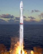
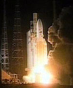
Image credit: Arianespace

Europe’s first mission to the Moon, SMART-1, lifted off successfully on board an Ariane-5 rocket Saturday evening. The rocket launched from the Guiana Space Centre at 2314 GMT (7:14 pm EDT) carrying SMART-1 and two other satellites. The spacecraft has deployed its solar arrays, and is currently undergoing an initial checkout of its systems to make sure that everything’s working properly. Its ion engine will begin accelerating the spacecraft towards the Moon on October 4th, but it’s going to be a long trip – it won’t arrive until March 2005.

SMART-1, Europe’s first science spacecraft designed to orbit the Moon, has completed the first part of its journey by achieving its initial Earth orbit after a flawless launch during the night of 27/28 September.

The European Space Agency’s SMART-1 was one of three payloads on Ariane Flight 162. The generic Ariane-5 lifted off from the Guiana Space Centre, Europe’s spaceport at Kourou, French Guiana, at 2014 hrs local time (2314 hrs GMT) on 27 September (01:14 Central European Summer time on 28 September).

42 minutes after launch, all three satellites had been successfully released into a geostationary transfer orbit (742 x 36 016 km, inclined at 7 degrees to the Equator). While the other two satellites are due to manoeuvre towards geostationary orbit, the 367 kg SMART-1 will begin a much longer journey to a target ten times more distant than the geostationary orbit: the Moon.

“Europe can be proud”, said ESA Director General Jean-Jacques Dordain, after witnessing the launch from ESA’s ESOC space operations centre in Darmstadt, Germany, “we have set course for the Moon again. And this is only the beginning: we are preparing to reach much further”.

The spacecraft has deployed its solar arrays and is currently undergoing initial checkout of its systems under control from ESA/ESOC. This checkout will continue until 4 October and will include with the initial firing of SMART-1’s innovative ion engine.

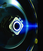
By ion drive to the Moon
Science and technology go hand in hand in this exciting mission to the Moon. The Earth and Moon have over 4 thousand million years of shared history, so knowing the Moon better will help scientists in Europe and all over the world to better understand our planet and will give them valuable new hints on how to better safeguard it” said ESA Director of Science David Southwood, following the launch from Kourou.

As the first mission in the new series of Small Missions for Advanced Research in Technology, SMART-1 is mainly designed to demonstrate innovative and key technologies for future deep space science missions.

The first technology to be demonstrated on SMART-1 will be Solar Electric Primary Propulsion (SEPP), a highly efficient and lightweight propulsion system that is ideal for long-duration deep space missions in and beyond our solar system. SMART-1’s propulsion system consists in a single ion engine fuelled by 82 kg of xenon gas and pure solar energy. This plasma thruster relies on the “Hall effect” to accelerate xenon ions to speed up to 16,000 km/hour. It is able to deliver 70 mN of thrust with a specific impulse (the ratio between thrust and propellant consumption) 5 to 10 times better than traditional chemical thrusters and for much longer durations (months or even years, compared to the few minutes’ operating times typical of traditional chemical engines).

The ion engine is scheduled to go into action on 30 September. At first, it will fire almost continuously “stopping only when the spacecraft is in the Earth’s shadow” to accelerate the probe (at about 0.2 mm/s2) and raise the altitude of its perigee (the lowest point of its orbit) from 750 to 20 000 km. This manoeuvre will take about 80 days to complete and will place the spacecraft safely above the radiation belts that surround the Earth.

Flight 162 ready for launch
Commissioning will be completed within 2 weeks, after which ESA’s control centre at ESOC will be in contact with the spacecraft for two 8-hour periods every week.

Once at a safe distance from Earth, SMART-1 will fire its thruster for periods of several days to progressively raise its apogee (the maximum altitude of its orbit) to the orbit of the Moon. At 200 000 km from Earth, it will begin receiving significant tugs from the Moon as it passes by. It will then perform three gravity-assist manoeuvres while flying by the Moon in late December 2004, late January and February 2005. Eventually, SMART-1 will be “captured” and enter a near-polar elliptical lunar orbit in March 2005. SMART-1 will then use its thruster to reduce the altitude and eccentricity of this orbit.

During this 18-month transfer phase, the solar-electric primary propulsion’s performance, and its interactions with the spacecraft and its environment, will be closely monitored by the Spacecraft Potential, Electron & Dust Experiment (SPEDE) and the Electric Propulsion Diagnostic Package (EPDP) to detect possible side-effects or interactions with natural electric and magnetic phenomena in nearby space.

A promising technology, Solar Electric Primary Propulsion could be applied to numerous interplanetary missions in the Solar System, reducing the size and cost of propulsion systems while increasing manoeuvring flexibility and the mass available for scientific instrumentation.

In addition to Solar Electric Primary Propulsion, SMART-1 will demonstrate a wide range of new technologies like a Li-Ion modular battery package; new-generation high-data-rate deep space communications in X and Ka bands with the X/Ka-band Telemetry and Telecommand Experiment (KaTE); a computer technique enabling spacecraft to determine their position autonomously in space, which is the first step towards fully autonomous spacecraft navigation.

Digging for the Moon’s remaining secrets
In April 2005 SMART-1 will begin the second phase of its mission, due to last at least six months and dedicated to the study of the Moon from a near polar orbit. For more than 40 years, the Moon has been visited by automated space probes and by nine manned expeditions, six of which landed on its surface. Nevertheless, much remains to be learnt about our closest neighbour, and SMART-1’s payload will conduct observations never performed before in such detail.

The Advanced/Moon Micro-Imaging Experiment (AMIE) miniaturised CCD camera will provide high-resolution and high-sensitivity imagery of the surface, even in poorly lit polar areas. The highly compact SIR infrared spectrometer will map lunar materials and look for water and carbon dioxide ice in permanently shadowed craters. The Demonstration Compact Imaging X-ray Spectrometer (D-CIXS) will provide the first global chemical map of the Moon and the X-ray Solar Monitor (XSM) will perform spectrometric observations of the Sun and provide calibration data to D-CIXS to compensate for solar variability.

The SPEDE experiment used to monitor Solar Electric Primary Propulsion interactions with the environment will also study how the solar wind affects the Moon.

The overall data collected by SMART-1 will provide new inputs for studies of the evolution of the Moon, its chemical composition and its geophysical processes, and also for comparative planetology in general.

Paving the way for future space probes
In addition to valuable lunar science, SMART-1’s payload will be involved in the mission’s technology demonstrations to prepare for future-generation deep space missions.

For instance, the AMIE camera will be used to validate the On-Board Autonomous Navigation (OBAN) algorithm, which correlates data from sensors and star trackers to provide navigational data. It will also participate in a laser communication link experiment with ESA’s optical ground station at the Teide Observatory in Tenerife, Canary Islands, trying to detect an incoming laser beam from the ground.

Using both AMIE and KaTE hardware, the Radio Science Investigation System (RSIS) experiment will demonstrate a new way of gauging the interiors of planets and their moons by detecting the well-known tilting motion of the Moon. This technology can be used later by ESA planetary missions.

SMART-1 was developed for ESA by the Swedish Space Corporation, as prime contractor, with contributions from almost 30 contractors from 11 European countries and the United States. Despite its small size, the spacecraft carries 19 kg of science payload consisting in experiments led by Principal Investigators from Finland, Germany, Italy, Switzerland and the United Kingdom.

Despite its relatively small budget and short development schedule, SMART-1 holds tremendous potential for future missions and is a clear illustration of Europe’s ambitions in the exploration of the solar system, also highlighted by June’s launch of Mars Express, which has now completed over the half on its journey to Mars, and the launch of Rosetta, due in February 2004, to visit comet Churyumov-Gerasimenko.

Original Source: ESA News Release