Huge Iceberg Breaks Away from Antarctica

Image credit: NASA

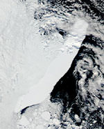
NASA satellites have been watching a gigantic iceberg as it disrupts the fragile Antarctic marine environment. The iceberg, named C-19, is 32 km wide and 200 km long; it broke off the Ross Ice Shelf back in May 2002. The problem is that the iceberg stopped winter sea ice from moving out of the Ross Sea region. Phytoplankton, which needs sunlight, was reduced by 90%, and so the rest of the ecosystem suffered too. The iceberg is being watched with NASA’s Terra and OrbView2 satellites.

NASA satellites observed the calving, or breaking off, of one of the largest icebergs ever recorded, named “C-19.”

C-19 separated from the western face of the Ross Ice Shelf in Antarctica in May 2002, splashed into the Ross Sea, and virtually eliminated a valuable food source for marine life. The event was unusual, because it was the second-largest iceberg to calve in the region in 26 months.

Over the last year, the path of C-19 inhibited the growth of minute, free-floating aquatic plants called phytoplankton during the iceberg’s temporary stopover near Pennell Bank, Antarctica. C-19 is located along the Antarctic coast and has diminished little in size. Since phytoplankton is at the base of the food chain, C-19 affects the food source of higher-level marine plants and animals.

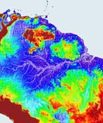
Kevin R. Arrigo and Gert L. van Dijken of Stanford University, Stanford, Calif., used chlorophyll data from NASA’s Sea-viewing Wide Field-of-view Sensor (SeaWiFS). The instrument, on the OrbView-2 satellite, also known as SeaStar, was used to locate and quantify the effects of C-19 on phytoplankton. The researchers were able to pinpoint iceberg positions by using images from the Moderate Resolution Imaging Spectroradiometer (MODIS), an instrument aboard NASA’s Terra and Aqua satellites. The findings from this NASA-funded study appeared in a recent issue of the American Geophysical Union’s Geophysical Research Letters.

C-19 is about twice the size of Rhode Island. When it broke off the Ross Ice Shelf, the iceberg was 32 km (almost 20 miles) wide and 200 km (124 miles) long. It was not as large as the B-15 iceberg that broke off of the same ice shelf in 2001 but among the largest icebergs ever recorded.

Since it was so large, C-19 blocked sea ice from moving out of the southwestern Ross Sea region. The blockage resulted in unusually high sea-ice cover during the spring and summer. Consequently, light was blocked. Phytoplankton blooms that occur on the ocean surface were dramatically diminished, and primary production was reduced by over 90 percent, relative to normal years.

Primary production is the formation of new plant matter by microscopic plants through photosynthesis. Phytoplankton is at the base of the food chain. If they are not able to accomplish photosynthesis, all organisms above them in the food chain will be affected. “Calving events over the last two decades indicate reduced primary productivity may be a typical consequence of large icebergs that drift through the southwestern Ross Sea during spring and summer,” Arrigo said.

Arrigo and van Dijken also used imagery from the Defense Meteorological Satellite Program (DMSP) satellite Special Sensor Microwave Imager and Scanning Multichannel Microwave Radiometer, managed by the U.S. Department of Defense. The data was used to monitor the impact of C-19 on the movement of sea ice. The data is archived at the National Snow and Ice Data Center, University of Colorado, Boulder.

Arrigo said most of the face of the Ross Ice Shelf has already calved. There is another large crack, but it is very difficult to predict if and when another large iceberg will result.

NASA’s Earth Science Enterprise is dedicated to understanding the Earth as an integrated system and applying Earth System Science to improve prediction of climate, weather, and natural hazards using the unique vantage point of space.

Original Source: NASA News Release

Twin Telescopes Peer at Distant Galaxy

Image credit: NASA/JPL

Two linked telescopes at the W.M. Keck Observatory on Hawaii’s Mauna Kea took a good look at galaxy NGC 4151 in the infrared spectrum. Located 40 million light years from Earth, NGC 4151 has been well studied by telescopes in various wavelengths, but this is the most detailed infrared image produced. The Keck interferometer works by combining the light from two 10-metre telescopes to create a virtual telescope that’s the equivalent of an 85-metre telescope.

A galaxy far beyond our own Milky Way, with a monstrous, churning black hole in its center, has been observed by two optical telescopes working in unison as an interferometer. These observations reveal the finest level of detail in a galaxy ever produced at infrared wavelengths.

Two linked telescopes at the W.M. Keck Observatory on Mauna Kea, Hawaii, observed the inner regions of the galaxy NGC 4151. The Keck Interferometer combines the world’s two largest optical telescopes. A paper on the findings will appear in the October 20 issue of the Astrophysical Journal Letters.

NGC 4151 is 40 million light years from Earth, far beyond the most distant object previously detected by this type of telescope system, which was about 3,000 light years from Earth. These observations marked the first time an optical/infrared interferometer detected any object outside our galaxy and were followed a few weeks later by observations of a second galaxy with the European Southern Observatory’s Very Large Telescope Interferometer.

“This opens a whole new area of research on galaxies other than our own,” said Dr. Rachel Akeson, an astronomer at the Michelson Science Center at the California Institute of Technology in Pasadena. The Keck Interferometer, with its 10-meter (33-foot) telescopes, has the sensitivity needed to detect objects outside our galaxy.

The Keck Interferometer gathers light waves with two telescopes, then combines the waves so they interact, or “interfere” with each other. The system transports the light to a laboratory located between them, where a beam combiner and infrared camera combine and process the light. This technique simulates a much larger, more powerful telescope. In this respect, the Keck Interferometer is equivalent to an 85-meter (279-foot) telescope.

“Interferometry provides the angular resolution, or ability to resolve fine details, to make these kinds of observations,” said the interferometer system architect, Dr. Mark Colavita of NASA’s Jet Propulsion Laboratory, Pasadena, Calif.

“We couldn’t observe objects as faint as this galaxy before with an interferometer.” Adaptive optics on 10-meter telescopes provides the sensitivity to make this observation,” said Dr. Peter Wizinowich, interferometer team lead for the W.M. Keck Observatory at the California Association for Research in Astronomy, Kamuela, Hawaii.

NGC 4151, well studied with telescopes and instruments at many wavelengths, is believed to have a black hole at its center surrounded by a doughnut-shaped ring of dust.”The black hole is estimated to be 10 million times as massive as our Sun, and 10 times more massive than the black hole at the center of our own galaxy, the Milky Way. Like all black holes, its gravitational pull is so powerful that nothing, not even light, can escape. However, as it gobbles up nearby material, a fraction of the material is spit out in a jet.

“We’re interested in studying galaxies with massive black holes,” said Dr. Mark Swain, a JPL astronomer and lead author of the paper. “We found that emission in NGC 4151 was unexpectedly compact. This indicates the light we saw is likely coming from a disc of material falling into the massive black hole.”

The observations were made on May 19 and 20, 2003, by a team of scientists from JPL, the California Association for Research in Astronomy, and the Michelson Science Center. Akeson, Colavita, Swain and Wizinowich are part of the team.

The Keck Interferometer is part of NASA’s Origins Program, which seeks to answer the questions: Where did we come from? Are we alone? The development of the Keck Interferometer is managed by JPL for NASA’s Office of Space Science, Washington, D.C. JPL is a division of the California Institute of Technology. The W.M. Keck Observatory is funded by Caltech, the University of California and NASA, and is managed by the California Association for Research in Astronomy, Kamuela, Hawaii.

Original Source: NASA/JPL News Release

ESA Chooses Designers for New Mars Missions

Image credit: ESA

Three European firms have won contracts to design the European Space Agency’s ExoMars spacecraft – a mission that is expected to launch to the Red Planet in 2009. ExoMars will consist of an orbiter and a rover that will land on Mars, and explore some of its surface. The three winning teams are Alenia Spazio, Alcatel Space and EADS Astrium. Teams have also been selected to provide design studies for the Mars Sample Return mission – where a spacecraft will land on Mars, collect samples, and then return them to Earth.

A major milestone in ESA?s long-term Aurora programme of Solar System exploration has been passed with the announcement of the winners of competitive contracts for two of the programme?s key robotic missions ? ExoMars and Earth re-entry Vehicle Demonstrator (EVD).

A major milestone in ESA?s long-term Aurora programme of Solar System exploration has been passed with the announcement of the winners of competitive contracts for two of the programme?s key robotic missions ? ExoMars and Earth re-entry Vehicle Demonstrator (EVD).

Alenia Spazio (Italy), Alcatel Space (France) and EADS Astrium (France) are heading the three industrial teams selected to carry out a full mission design for ExoMars, the Aurora exobiology mission to Mars.

At the same time, two industrial teams, headed by EADS LV (Launch Vehicles) of France and Surrey Satellite Technology Limited (SSTL) of the United Kingdom respectively, have been selected for the pre-development phase (officially known as Pre-Phase A) of the EVD mission.

?Following the Invitations To Tender (ITTs) for these contracts, issued in April-May 2003, there was an overwhelming and enthusiastic response from industry,? said Bruno Gardini, Aurora Project Manager.

?We were delighted by the number and the excellence of the proposals received,? he added. ?It was also pleasing to see that many of them included new, innovative ideas from industry.?

ExoMars
The ExoMars mission, to be launched in 2009, is the first of the major Flagship missions in the Aurora programme. It includes an orbiter and a descent module that will land a large (200 kg), high-mobility rover on the surface of Mars. After delivery of the lander/rover, the ExoMars orbiter will also operate as a data relay satellite between the Earth and the vehicle on the Martian surface.

The primary objective of the ExoMars rover will be to search for signs of life, past or present, on the Red Planet. Additional measurements will be taken to identify potential surface hazards for future human missions, to determine the distribution of water on Mars and to measure the chemical composition of the surface rocks.

Three parallel Phase A studies for the ExoMars Mission will be carried out by industrial teams that include companies from ESA member states and Canada:

  • * Alenia Spazio (Italy) with subcontractors OHB (Germany), GMV (Spain), SEA (UK), SSC (UK) and Laben (Italy).
  • * Alcatel Space (France) with subcontractors Deimos (Spain), ETCA (Belgium), Fluid Gravity Engineering (UK), Kayser Threde (Germany), Laben (Italy), MD Robotics (Canada), NGC Aerospatiale (Canada), QinetiQ (UK), Vorticity (UK).
  • * EADS Astrium (France) with subcontractors Astrium Ltd. (UK), EADS LV (France) and SAS (Belgium).

The contracts cover the design of the entire ExoMars mission, from launch, through the long interplanetary voyage to the landing of the rover on the planet.

?This is an exciting landmark for the Aurora programme, since these are the first contracts dedicated to mission development rather than technical studies,? said Gardini.

?With the participation of all major European aerospace companies, the proposed concepts will make the best use of their extensive experience, gathered over many years, in the design and development of interplanetary missions,? he said.

?The studies will also bring to fruition several years of efforts from national and international programmes in investigating and planning Mars missions.

?From the quality of the proposals, the agency is very confident that the technical baseline will be fully consolidated by the end of the Phase A studies and that the spacecraft design will then be defined to a level of detail commensurate with a prompt start of Phase B.?

Depending on the availability of funding, the Phase B studies for ExoMars are planned to start in 2004.

Earth re-entry Vehicle Demonstrator (EVD)
The second Aurora Flagship mission is a Mars Sample Return (MSR), planned for 2011. Its main goal will be the retrieval of rock samples from the Martian surface and subsurface for subsequent analysis in laboratories on Earth.

In order to ensure the success of this challenging mission, a number of new technologies will have to be developed and tested. Conceived as a small, technology-driven Arrow-class mission, the Earth re-entry Vehicle Demonstration will be used to validate the design of the small MSR capsule that will bring back the precious samples of Martian soil.

The EVD is expected to be launched in 2007. The baseline mission foresees the insertion into a highly elliptical Earth orbit of a small spacecraft carrying a re-entry capsule. In order to reproduce the final phase of a typical Mars return mission, the capsule will then carry out a ballistic re-entry into Earth?s atmosphere at speeds of up to 45,000 km/h.

Two industrial teams have been selected for the parallel EVD mission Pre-Phase A studies. The concept presented by the industrial team, under the leadership of EADS LV (France) with the participation of OHB System (Germany) and Plansee (Austria) is solidly based on the experience of past projects.

The industrial team led by SSTL (UK), a company well known for its experience in small highly integrated spacecraft, has devised a very innovative concept well adapted for a small technology mission. The participation of highly specialised companies, Fluid Gravity Engineering (UK), Kayser Threde GmbH (D) and Vorticity Ltd. (UK) ensures an excellent coverage of the mission?s most critical technologies.

?The expectations are for highly competitive and exciting Pre-Phase A studies,? said Gardini.

The next Aurora contract for Phase A studies will concern the Mars Sample Return mission. Industrial proposals were submitted on 1 August and the evaluation is nearly completed. The names of the selected companies are expected to be announced in early October.

Original Source: ESA News Release

10,000 New Images of Mars

Image credit: NASA/JPL

NASA has released 10,232 new images of the Red Planet taken by the Mars Global Surveyor spacecraft, including wind whipped polar dunes, steep-walled valleys, and boulder-strewn terrain. The images were taken over the course of several months, from August 2002 to February 2003, and they include views all over the planet. This brings the total number of images taken by Surveyor in six years of observation to more than 134,000.

Thousands of newly released portraits of martian landscapes from NASA’s Mars Global Surveyor spacecraft testify to the diversity of ways geological processes have sculpted the surface of our neighboring planet.

Swirling textures that some scientists call “taffy-pull terrain? fill one new image from the plains of southern Mars, for example. Other images reveal details of features such as wind-whipped polar dunes and steep-sided valleys carved by flowing water or lava.

The 10,232 newly released pictures from the Mars Orbiter Camera on Mars Global Surveyor bring the total number of images in the camera’s online gallery to more than 134,000. The new batch is at: http://www.msss.com/mars_images/moc/2003/09/30/.

“Mars just keeps astounding us with its complexity,” said Dr. Ken Edgett, staff scientist for Malin Space Science Systems, San Diego, Calif, which built and operates the Mars Orbiter Camera.

The new group of images was taken between August 2002 and February 2003, then validated and archived by the camera team. It includes many views of north polar terrain, extremely clear-atmosphere views of a deep southern basin named Hellas Planitia, and a variety of martian landforms between the north pole and the southern middle latitudes. The pictures show martian surface details down to the size of a large sport utility vehicle.

Since Mars Global Surveyor began orbiting Mars six years ago, the mission has provided a wealth of information about the planet’s atmosphere and interior, as well at its surface.

Evaluation of landing sites for NASA’s Spirit and Opportunity, two Mars Exploration Rover spacecraft due to land on Mars in January 2004, relied heavily on mineral mapping, detailed imagery and topographic measurements by Global Surveyor.

Additional information about Mars Global Surveyor is available online at: http://mars.jpl.nasa.gov/mgs/.

In addition to semi-annual releases of large collections of archived pictures, the Mars Orbiter Camera team posts a new image daily and recently began soliciting public suggestions for camera targets on Mars. The full gallery is available at: http://www.msss.com/moc_gallery/.

Original Source: NASA News Release

Sea Launch Lofts Galaxy XIII/Horizons-1

Image credit: Boeing

Sea Launch successfully launched Boeing-built Galaxy XIII/Horizons-1 satellite from the equator in the Pacific Ocean early this morning. A Zenit-3SL rocket lifted off from the launch platform at 0403 GMT (12:03am EDT) and carried the dual purpose satellite into orbit. A ground tracking station received signals from the satellite about an hour after launch, indicating that it was functioning normally and in the right trajectory to make its journey to geosynchronous orbit. It will eventually provide a variety of telecommunication services to North America.

Last night, a successful launch orbited Galaxy XIII/Horizons-1, a Boeing 601HP satellite built by Boeing [NYSE:BA] for PanAmSat Corporation, Wilton, Conn., and JSAT Corporation of Japan. The satellite will provide coverage over North America, Central America, Alaska and Hawaii from an orbital slot between the Hawaiian Islands and the U.S. west coast.

The 4,090 kg (8,998 lbs) satellite rocketed to geosynchronous transfer orbit aboard a Zenit-3SL provided by Sea Launch Company, LLC. Lift-off occurred at 9:03 p.m. PDT (4:03 a.m. GMT) from the Sea Launch Odyssey Launch Platform positioned on the equator in the Pacific Ocean. The spacecraft received its first signals at about 10:03 p.m. PDT at a ground station at Fucino, Italy, confirming normal operation.

?Communications satellites have erased the distance between the far corners of the globe,? said Dave Ryan, president of Boeing Satellite Systems International, a wholly owned subsidiary of Boeing. ?Galaxy XIII/Horizons-1 will continue that heritage as it also links the aspirations of PanAmSat and JSAT, who will use it to deliver trans-Pacific communications services. We are very proud to continue our legacy of teamwork with these two very important long time customers.?

Galaxy XIII/Horizons-1 with a final orbit slot at 127 degrees west longitude is the 207th Boeing-built commercial communications satellite launched to date. Forty years ago this year, the Boeing-built Syncom ushered in a revolution as the world?s first geosynchronous communications satellite.

Galaxy XIII/Horizons-1 will support PanAmSat?s domestic cable program distribution services as well as the Horizons international joint venture of PanAmSat and JSAT. The spacecraft will carry a total of 48 active transponders, 24 each in Ku-band and C-band. The Horizons partnership will use the spacecraft’s Ku-band payload, known as Horizons-1, to offer a variety of digital video, Internet and data services. In addition, the Ku-band payload on Galaxy XIII/Horizons-1 will be able to deliver content and services between the United States and Asia, using a teleport in Hawaii.

The C-band portion of the new spacecraft, known as Galaxy XIII, will be operated separately as part of PanAmSat’s Galaxy cable neighborhood, which serves the domestic U.S. cable industry. Galaxy XIII will be used to replace capacity on Galaxy IX, a Boeing 376 model that will move to a new orbital position and continue to provide services.

PanAmSat Corporation (NASDAQ:SPOT) is the premier provider of global video and data broadcasting services via satellite. For more information on PanAmSat, visit the company’s web site at www.panamsat.com. JSAT is a leading satellite operator in the Asia-Pacific region. For more information on JSAT, visit the company’s web site at www.jsat.net.

A unit of The Boeing Company, Boeing Integrated Defense Systems is one of the world’s largest space and defense businesses. Headquartered in St. Louis, Boeing IDS is a $25 billion business that provides systems solutions to its global military, government and commercial customers. It is a leading provider of intelligence, surveillance and reconnaissance; the world’s largest military aircraft manufacturer; the world’s largest satellite manufacturer and a leading provider of space-based communications; the primary systems integrator for U.S. missile defense; NASA’s largest contractor; and a global leader in launch services.

Original Source: Boeing News Release

SMART-1 Fires its Ion Engine

Image credit: ESA

The European Space Agency’s SMART-1 spacecraft passed an important test on Tuesday when it started up its ion engine – the propulsion system that will take it to the Moon. Engineers at the ESA’s control centre sent the spacecraft the command to test fire its engine for an hour, and they didn’t encounter any problems. SMART-1 will use the ion engine to make bigger and bigger orbits around the Earth until it’s caught by the gravity of the Moon. Then it will use the engine to make smaller orbits around the Moon until it’s close enough to begin gathering science data about the surface.

SMART-1’s revolutionary propulsion system was successfully fired at 12:25 UT on 30 September, 2003, in orbit around the Earth.

Engineers at ESOC, the European Space Agency’s control centre in Darmstadt, Germany, sent a command to begin the firing test, which lasted for one hour. This was similar to a trial performed on Earth before SMART-1 was launched.

Several months ago, the ion engine, or Solar Electric Primary Propulsion (SEPP) system, had been placed in a vacuum chamber on the ground and its functions and operation were measured. Now in space and in a true vacuum, the ion engine actually worked better than in the test on ground and has nudged SMART-1 a little closer to the Moon.

This is the first time that Europe flies an electric primary propulsion in space, and also the first European use of this particular type of ion engine, called a ‘Hall-effect’ thruster.

The SEPP consists of a single ion engine fuelled by xenon gas and powered by solar energy. The ion engine will accelerate SMART-1 very gradually to cause the spacecraft to travel in a series of spiralling orbits – each revolution slightly further away from the Earth – towards the Moon. Once captured by the Moon’s gravity, SMART-1 will move into ever-closer orbits of the Moon.

As part of one of the overall mission objectives to test this new SEPP technology, the data will now be analysed to see how much acceleration was achieved and how smoothly the spacecraft travelled. If the ion engine is performing to expectations, ESA engineers will regularly power up the SEPP to send SMART-1 on its way.

Original Source: ESA News Release

Sea Launch Countdown Begins

Image credit: Boeing

The Sea Launch arrived at the equator in the Pacific Ocean on the weekend, and began the 72-hour countdown to the launch of the Galaxy XIII/Horizons-1 satellite on board a three-stage Zenit-3SL rocket. If all goes well, the rocket will lift off on October 1 at 0403 GMT (12:03am EDT) and carry the satellite to a high perigee geosynchronous transfer orbit. Once it reaches its final destination, the satellite will provide data, television, and voice communication services to North America.

The Sea Launch team arrived at the equatorial launch site this weekend and initiated a 72-hour countdown to liftoff of the Galaxy XIII/Horizons-1 mission for PanAmSat Corporation and JSAT Corporation. All systems are proceeding on schedule for the launch, scheduled for Tuesday, September 30, 9:03 pm PDT (4:03:00 GMT, October 1) at the opening of the 39-minute launch window.

The Odyssey Launch Platform and its sister ship, the Sea Launch Commander, arrived at the launch site on Saturday. The marine crew began the process of ballasting the Launch Platform about 65 feet, to launch depth, in preparation for launch operations. The vessels are now stationed alongside each other, frequently connected by a link bridge that enables foot traffic between them. On the day of launch, the platform will be evacuated and all personnel will be stationed on the ship, three miles uprange, throughout launch operations.

Sea Launch?s three-stage Zenit-3SL rocket will loft the 4,090 kg (9,081 lb) Galaxy XIII/Horizons-1 satellite to a high perigee geosynchronous transfer orbit. Following the successfully completed mission, the spacecraft will be located in geostationary orbit at 127 degrees West Longitude. Built by Boeing Satellite Systems in El Segundo, Calif., the 601 HP model spacecraft is designed to offer a variety of digital video, Internet and data services to North America, Central America, Alaska and Hawaii. Horizons-1 is jointly owned by PanAmSat and JSAT, and supports their Horizons venture. It will provide expanded Ku-band services in North America and extended services to Japan and Asia via a Hawaii-based relay station. The C-band payload, Galaxy XIII, which will be operated independently by PanAmSat, will offer the first high-definition neighborhood in the U.S. cable arc.

Sea Launch will provide a live satellite broadcast and simultaneous webcast of the Galaxy XIII/Horizons-1 mission on September 30, beginning at 8:45pm PDT (3:45:00 GMT, October 1). The broadcast, featuring live video from the launch site as well as commentary, may be downlinked from satellite coordinates posted at the following site:
www.boeing.com/nosearch/sealaunch/broadcast.html
Streaming video of the mission will be carried live at:
www.sea-launch.com/current_index_webcast.html

Original Source: Boeing news release

Envisat is Watching the World’s River Levels

Image credit: ESA

The European Space Agency’s demonstrated the capability of its Envisat Earth monitoring satellite to track the water levels of inland lakes and rivers; spots on the Earth that were previously invisible to previous radar altimetry. The Radar Altimeter 2 on board Envisat sends 1800 radar pulses a second from 800 km altitude and then calculates how long they take to return – this tells the device its exact distance to the planet. A team from pored through the raw Envisat data and figured out a way to extract river water levels by spotting specific kinds of radar echos. ESA will release 12 years of river levels for scientists to study.

For over a decade ESA has used satellites to bounce radar pulses off the Earth and precisely measure the height of ocean and land surfaces. But inland lakes and rivers have been effective blind spots for radar altimetry ? at least until now.

Next week ESA previews a new product range called River and Lake Level from Altimetry that provides previously inaccessible information on water levels of major lakes and rivers across the Earth’s surface, derived from Envisat and ERS radar altimeter measurements.

Hydrologists can use this new data to monitor river heights around the planet, assess the impact of global warming and help with water resource management. Inland water bodies are important as key sources of both water and food for the people living round them. They are also often regions of maximum biodiversity and represent early indicators of regional climate change.

A new processing algorithm has been developed to extract rivers and lakes level findings from raw radar altimeter data. The development effort was headed by Professor Philippa Berry of the UK’s De Montfort University: “The new radar altimeter product is a great leap forward for hydrologists. It gives them a new tool to study both the historical changes in water table levels and critically important data to use in forecasting models of water availability, hydroelectric power production, flood and drought events and overall climate changes.”

The Radar Altimeter 2 (RA-2) flown aboard ESA’s Envisat environmental satellite is the improved follow-on to earlier radar altimeters on the ERS-1 and ERS-2 spacecraft. From its 800 km-high polar orbit it sends 1800 separate radar pulses down to Earth per second then records how long their echoes take to return ? timing their journey down to under a nanosecond to calculate the exact distance to the planet below.

Radar altimeters were first flown in space back in the 1970s, aboard NASA’s Skylab and Seasat. These early efforts stayed focused firmly on the oceans, as less-smooth land surfaces returned indecipherable signals. But as the technology improved reliable land height data became available. Envisat’s RA-2 has an innovative ‘four-wheel drive’ tracking system allowing it to maintain radar contract even as the terrain below shifts from ocean to ice or dry land.

But rivers and lakes have proved tougher targets. Large lakes and wide rivers such as the Amazon often returned tantalising ‘wet’ radar signals, but echoes from nearby dry land distorted most such signals.

Believing full-fledged river and lake level monitoring was nevertheless feasible, ESA awarded a contract to De Montfort University to develop a suitable software product, with Lancaster University advising on field hydrology.

The De Montfort University team proceeded by painstakingly combing through many gigabytes of raw data acquired over rivers and lakes, taking note of the type of echo shapes that occurred. They sorted different echo shapes into distinct categories, then created an automated process to recognise these shapes within ‘wet’ signals and eventually extract usable data from them.

“To do this, the shape of each individual echo has to be analysed, and the exact time corresponding to the echo component from the lake or river must be calculated,” explained Professor Berry. “As well as identifying and removing the echo from surrounding land, this process is complicated by the frequent occurrence of islands and sandbars, particularly in river systems. But in the end this approach has been shown to be very effective indeed, with successful retrieval of heights from the majority of the Earth’s major river and lake systems.”

Next week sees the release of the first demonstration products using this new algorithm, containing representative data from the last seven years for rivers and lakes across Africa and South America. The plan is that global altimeter data for the last 12 years will then be reprocessed to provide hydrologists with historical information, invaluable for assessing long-term trends.

ESA also intends to install operational software in its ground segment so eventually the product can be delivered to users in near-real time, within three hours or less of its acquisition from space.

Hydrologists need no previous knowledge of radar altimetry to make use of the new data, with one product known as River Lake Hydrology providing data corresponding to river crossing points, just as though there were actual river gauges in place.

Such gauges are the traditional way that river and lake level measurements are obtained, but their number in-situ has declined sharply in the last two decades. The new product will compensate for this growing lack of ground data.

The other product is called River Lake Altimetry, intended for altimetry specialists, and provides all crossing points for a water body, together with detailed information on all instrumental and geophysical corrections.

Previews of both products can be accessed via a dedicated website (see right hand bar) or on a free CD ? email [email protected] to order a copy. Both products are being formally announced at the Hydrology from Space conference, beginning Monday 29 September in Toulouse.

Original Source: ESA news release

Lockheed Martin and Northrop Grumman Join Forces on Space Plane Bid

Image credit: NASA

Lockheed Martin and Northrop Grumman announced that they will be working together on their proposal for NASA’s Orbital Space Plane (OSP). This consortium will compete against Boeing, and NASA will select its supplier in August 2004. NASA will ask the winning team to build a vehicle by 2008 that can rescue the crew of the International Space Station, and then transfer two astronauts to the station by 2012. The OSP will be launched atop an Atlas V or Delta IV rocket.

Lockheed Martin Corporation’s (NYSE: LMT – News) Space Systems Company and Northrop Grumman Corporation’s (NYSE: NOC – News) Integrated Systems sector have moved NASA a significant step closer to its goal of launching a safe, affordable Orbital Space Plane (OSP) by 2008.

The two companies have agreed to establish a teaming arrangement to compete for the full-scale development of the OSP. Lockheed Martin will lead the new team as the system prime contractor while Northrop Grumman will serve as Lockheed Martin’s principal teammate and subcontractor. NASA expects to select a prime contractor team for the full-scale OSP development by August 2004.

“The diverse talents, technical resources and aerospace systems experience of our two companies will help NASA reduce the schedule and cost risks of the accelerated OSP program,” said Michael Coats, vice president, Lockheed Martin’s Advanced Space Transportation. “Our collective expertise in large-scale systems integration, space systems engineering, launch vehicles, military aircraft, and autonomous flight provide a critical foundation for NASA’s efforts to restore vigor and confidence to the nation’s human spaceflight program.”

NASA has specified that the OSP must provide a crew rescue capability for the International Space Station by 2008, a two-year acceleration in the OSP development schedule outlined last spring. A two-way crew transfer OSP is also required by 2012. OSP will be launched on either an Atlas V or Delta IV rocket.

“The combination of Lockheed Martin and Northrop Grumman on OSP provides NASA with a critical opportunity to broaden the nation’s industrial base in the area of human spaceflight,” said Doug Young, director of Space Access Programs for Northrop Grumman Integrated Systems. “The team will have the capability to design, develop, test, produce, support and maintain a cost-effective, technically superior crew rescue and transfer OSP system.”

Northrop Grumman and Lockheed Martin are currently performing separate OSP contracts for NASA. Awarded in April 2003, these contracts focus on helping NASA develop Level One Requirements for the OSP and on defining architectural concepts for proposed OSP crew rescue and transfer vehicles. Northrop Grumman will complete the current phase of its OSP contract, then become a Lockheed Martin subcontractor.

Headquartered in Bethesda, Md., Lockheed Martin employs about 125,000 people worldwide and is principally engaged in the research, design, development, manufacture and integration of advanced technology systems, products and services. The corporation reported 2002 sales of $26.6 billion.

Northrop Grumman Integrated Systems, headquartered in El Segundo, Calif., is a premier aerospace and defense systems integration enterprise. It designs, develops, produces and supports network-enabled integrated systems and subsystems for government and civil customers worldwide. Integrated Systems delivers best-value solutions, products and services that support NASA, military and homeland defense missions in the areas of intelligence, surveillance and reconnaissance; battle management command & control and integrated strike warfare.

Original Source: Lockheed Martin news release

NASA Rejects that the Space Station is Dangerous

NASA has rejected a warning from the outgoing members of its Aerospace Safety Advisory panel that the International Space Station is an “accident, waiting to happen.” Space station manager William Gerstenmaier said on Monday that all the teams working on the station need to have focus and attention to detail, but it’s not seriously dangerous. The safety panel pointed out that the battery pack on the station could accidentally vent into the station, which would be catastrophic – NASA acknowledged it was a risk and the Russians will be providing a safer battery design.