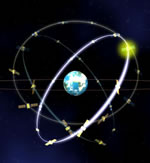
Europe Approves Global Navigation System

Image credit: ESA

The governments of the European Union gave their final approval for the launch of the new Galileo satellite navigation system, similar to the US-built Global Positioning System. The $3.6 billion system has had several delays to this point, but now the 30-satellite network is scheduled for completion by 2008. Consensus was reached at a meeting on Monday in Paris with the members of the European Space Agency.

The European Space Agency is now able to finalise the conditions for participation in the Galileo navigation programme and to approve the Galileo Joint Undertaking foundation act to be soon signed by ESA and the European Union.

The agreement reached among ESA member states today clears the way for the official launch of the legal entity which will have the task of coordinating ESA and EU involvement in Galileo, the European initiative to develop a global satellite navigation system.

“This is a great day for Europe in general and its space community in particular. Conscious of the economic, industrial and strategic importance of satellite navigation, our Member States have reached agreement in the common interest. We are now able to continue with Galileo, a major programme from which all citizens will benefit. Galileo is definitely a reality”, said Antonio Rodot?, ESA Director General at the end of the Council Meeting at Delegate level held in Paris today while informing German Minister of Education and Research, Mrs. Edelgard Bulmahn, Chairwoman of the ESA Council at Ministerial level to be held in Paris tomorrow.

?I am extremely delighted with this result. Galileo is now on its way . I am grateful to all ESA Member States that have striven to find a balanced solution and pleased that Europe has once again proven to be able to remain at the forefront of high level technology for a programme useful to each of us in our everyday life? said Mrs. Bulmahn when she heard the good news.

The Galileo Joint Undertaking, to be headquartered in Brussels, has a key part to play in implementing the various phases of the programme. This unique organisational structure will pave the way for the entity that will in due course operate the Galileo system. It will be responsible for the Galileo development and validation phase and also for preparations for system deployment and operations.

The founding members of the Galileo Joint Undertaking are the European Space Agency and the European Union, represented by the European Commission.

Galileo will complement the existing satellite navigation system, which presently relies entirely on GPS, the American Global Positioning System. Developed by ESA and the EU on the basis of equal co-funding, Galileo is designed to provide a complete civil system. Scheduled to be operational by 2008, it will offer the citizens of Europe and the world an accurate and secure satellite positioning capability.

A broad range of applications will be supported by the system : control of road, rail and sea traffic, synchronised data transmission between computers, and many others. Projections point to very significant economic benefits, with a return on investment of 4.6 and creation of over 140 000 jobs.

Galileo is the first instance of a project carried out jointly by the European Space Agency and the European Union.

The Galileo system will be built around 30 satellites (27 operational and 3 reserve craft) occupying three circular earth orbits, inclined at 56? to the Equator, at an altitude of 23 616 km. This configuration will provide excellent coverage of the planet. Two Galileo control centres will be established in Europe to control satellite operations and manage the navigation system.

Original Source: ESA News Release

Earthquakes Simulation Could Lead to Quake Forecasts

Image credit: NASA

NASA scientists are working on ways to predict earthquakes using an advanced computer simulation. The software is called QuakeSim, and it uses hundreds of thousands of measurements gathered by a variety of land and space-based instruments to calculate how the Earth’s crust deforms through plate tectonics. The technology is already starting to show results – one team has been able to identify regions in California with higher risks of earthquakes and predicted every magnitude 5+ quake since the year 2000 within 11 kilometres.

Advanced computer simulation tools now being developed by NASA and university researchers may soon give scientists new insights into the complex and mysterious physics of earthquakes and enable vastly improved earthquake forecasting.

Scientists at NASA?s Jet Propulsion Laboratory, Pasadena, Calif., together with NASA?s Goddard Space Flight Center, Greenbelt, Md.; Ames Research Center, Mountain View, Calif.; and several universities, are developing an advanced earthquake modeling system called QuakeSim. When completed in late 2004, QuakeSim?s simulation tools will help scientists learn more about what makes earthquakes happen.

The tools are based upon the latest technologies. For example, one uses finite element analysis, which solves complex computer modeling problems by breaking them into small pieces. For QuakeSim, the finite elements are tens to hundreds of thousands of measurements of how Earth?s crust deforms in response to movement of the giant tectonic plates Earth?s landmasses ride upon. The measurements are gathered through both ground and space-based techniques. The latter include global positioning system and interferometric synthetic aperture radar, which measure the ?quiet? (non-earthquake) motions associated with plate tectonics and the quake cycle.

QuakeSim Principal Investigator Dr. Andrea Donnellan of JPL calls QuakeSim a vital step toward eventual earthquake forecasting. ?The deformation of Earth?s crust and the interaction between quake faults is a complex 3-D process happening on timescales of minutes to thousands of years,? she said. ?Studying it requires sophisticated simulation models and high-performance supercomputers. The availability of space-based data and our current limited understanding of quake processes make this an ideal time to develop a system for studying deformation processes such as tectonics, quakes and volcanoes.?

?New quake models developed under QuakeSim are expected to yield future earthquake forecasts that will be used by a variety of federal and state agencies to develop decision support tools that will help mitigate losses from future large earthquakes,” Donnellan added.

QuakeSim?s three major simulation tools are Park, Virtual California and the Geophysical Finite Element Simulation Tool (Geofest).

Park simulates the evolution of a quake on a single, unstable fault over time. It is based upon current knowledge of the rate of movement (or ?slip?) and friction on a well-studied section of the San Andreas Fault in Parkfield, Calif., but is applicable to any fault or collection of faults. Park will be the tool of choice for researchers seeking to determine the nature and detectability of quake warning signals. It will determine how stress is distributed over a fault and how it is redistributed by quakes or ?quiet? seismic motion. It can also be used to compute the history of slip, slip speed and stress on a fault. Up to 1,024 computer processors will be used in parallel to demonstrate Park’s capability.

Virtual California simulates how California?s hundreds of independent fault segments interact and allows scientists to determine correlated patterns of activity that can be used to forecast seismic hazard, especially for quakes of magnitude 6 or greater. Patterns from the simulated data are compared to patterns in real data to strengthen understanding of the quake process. The approach’s potential is already being demonstrated. Under a joint NASA/Department of Energy study lead by Dr. John Rundle, director of the Center for Computational Science and Engineering at the University of California at Davis, Virtual California was used to identify regions of the state with elevated probabilities of quakes over the next decade. Since the study was completed in 2000, all of California’s five largest quakes of magnitude 5 or greater have occurred within 11 kilometers (6.8 miles) of these sites. The probability of this occurring randomly is about one in 100,000. The last three of these quakes occurred after the forecast map was published in the Proceedings of the National Academy of Sciences in February 2002.

Geofest creates 2-D and 3-D models of stress and strain in Earth?s crust and upper mantle in a complex geologic region with many interacting fault systems. It shows how the ground will deform in response to a quake, how deformation changes over time following a quake, and the net effects to the ground from a series of quakes. The entire Southern California system of interacting faults will be analyzed, covering a portion of the crust approximately 1,000 kilometers (621 miles) on a side. The simulation will require millions of equations and hundreds of computer processors.

In addition to JPL, the QuakeSim team includes the Davis and Irvine campuses of the University of California; Brown University, Providence, R.I.; Indiana University; and the University of Southern California. An independent review board provides oversight. Codes will be run on supercomputers at NASA?s Goddard, Ames and JPL facilities and other institutions. The California Institute of Technology in Pasadena manages JPL for NASA.

NASA’s Earth Science Enterprise is dedicated to understanding Earth as an integrated system and applying Earth system science to improve prediction of climate, weather and natural hazards using the unique vantage point of space. A primary goal of NASA’s solid Earth science program is assessment and mitigation of natural hazards. QuakeSim supports the Enterprise’s goal of developing predictive capabilities for quake hazards.

Original Source: NASA News Release

Northern Europe’s Annular Eclipse: May 31, 2003

On Saturday, May 31, an annular eclipse of the Sun will be visible from a good portion of the Northern Hemisphere. The best views will be in northern Scotland, Iceland and Greenland where the Sun will be visible as a ring of fire behind the moon, but even a partial eclipse will be visible from most of Europe, Northern Canada, the Middle East, and Asia. An annular eclipse occurs because the Moon’s orbit isn’t a perfect circle. If the Moon is at the closest part of its orbit when it passes in front of the Sun, it causes a total eclipse – at the furthest point, it’s an annular eclipse.

NASA Could Have Rescued Columbia Astronauts in Space

NASA now believes they could have launched the space shuttle Atlantis and four veteran astronauts to rescue the crew of Columbia had they realized the danger earlier. In the days after the February 1 tragedy, NASA said there was nothing that could have been done to fix Columbia’s wing, but the shuttle investigation board asked the agency to figure out what they could have done if they had known about the damage. Columbia’s 16 days of supplies could have been stretched to 30 to give time to mount a rescue mission.

China Launches Third Navigation Satellite

Chinese space officials announced on Sunday that a Long March 3-A rocket launched the third Beidou satellite, which will complete their home-grown satellite navigation system (similar to the US-built Global Positioning System). Although the system is primarily for civilian navigation, it will have military applications, and should give Chinese missiles better accuracy.

Mars Global Surveyor Snaps a Picture of Earth

Image credit: NASA

Ever wondered what the Earth would look like seen through a small telescope on Mars? Currently in orbit around the Red Planet, NASA’s Mars Global Surveyor took pictures of the Earth and Jupiter on May 8th, when they were aligned in the Martian sky. The image shows our planet in a “half-Earth” phase, and was processed so that both Earth and Moon are visible in the picture. The photograph shows Jupiter as well, including three of its brightest satellites.

What does Earth look like when viewed from Mars? At 13:00 GMT on 8 May 2003, the Mars Global Surveyor (MGS) Mars Orbiter Camera (MOC) had an opportunity to find out. In addition, a fortuitous alignment of Earth and Jupiter—the first planetary conjunction viewed from another planet—permitted the MOC to acquire an image of both of these bodies and their larger satellites. At the time, Mars and the orbiting camera were 139 million kilometers (86 million miles) from Earth and almost 1 billion kilometers (nearly 600 million miles) from Jupiter. The orbit diagram, above, shows the geometry at the time the images were obtained.

Because Jupiter is over 5 times farther from the Sun than Earth, two different exposures were needed to image the two planets. Mosaiced together, the images are shown above (top picture). The composite has been highly contrast-enhanced and “colorized” to show both planets and their satellites. The MGS MOC high resolution camera only takes grayscale (black-and-white) images; the color was derived from Mariner 10 and Cassini pictures of Earth/Moon and Jupiter, respectively, as described in the note below.

Earth/Moon: This is the first image of Earth ever taken from another planet that actually shows our home as a planetary disk. Because Earth and the Moon are closer to the Sun than Mars, they exhibit phases, just as the Moon, Venus, and Mercury do when viewed from Earth. As seen from Mars by MGS on 8 May 2003 at 13:00 GMT (6:00 AM PDT), Earth and the Moon appeared in the evening sky. The MOC Earth/Moon image has been specially processed to allow both Earth (with an apparent magnitude of -2.5) and the much darker Moon (with an apparent magnitude of +0.9) to be visible together. The bright area at the top of the image of Earth is cloud cover over central and eastern North America. Below that, a darker area includes Central America and the Gulf of Mexico. The bright feature near the center-right of the crescent Earth consists of clouds over northern South America. The image also shows the Earth-facing hemisphere of the Moon, since the Moon was on the far side of Earth as viewed from Mars. The slightly lighter tone of the lower portion of the image of the Moon results from the large and conspicuous ray system associated with the crater Tycho.

Jupiter/Galilean Satellites: When Galileo first turned his telescope toward Jupiter four centuries ago, he saw that the giant planet had four large satellites, or moons. These, the largest of dozens of moons that orbit Jupiter, later became known as the Galilean satellites. The larger two, Callisto and Ganymede, are roughly the size of the planet Mercury; the smallest, Io and Europa, are approximately the size of Earth’s Moon. This MGS MOC image, obtained from Mars orbit on 8 May 2003, shows Jupiter and three of the four Galilean satellites: Callisto, Ganymede, and Europa. At the time, Io was behind Jupiter as seen from Mars, and Jupiter’s giant red spot had rotated out of view. This image has been specially processed to show both Jupiter and its satellites, since Jupiter, at an apparent magnitude of -1.8, was much brighter than the three satellites.

Original Source: MSSS News Release

Galaxy Orbiting Milky Way in the Wrong Direction

Image credit: NRAO

Before this week, “Complex H” was thought to be a strange cloud of stars with an unusual trajectory near the Milky Way. But as it turns out, this object is actually a companion galaxy crashing into the outer reaches of our own galaxy in exactly the opposite direction of the Milky Way’s rotation. New observations from the National Science Foundation’s Robert C. Byrd Green Bank Telescope (the world’s largest steerable radio telescope) have placed the object at 108,000 light years from the Milky Way’s centre.

New observations with National Science Foundation’s Robert C. Byrd Green Bank Telescope (GBT) suggest that what was once believed to be an intergalactic cloud of unknown distance and significance, is actually a previously unrecognized satellite galaxy of the Milky Way orbiting backward around the Galactic center.

Jay Lockman of the National Radio Astronomy Observatory (NRAO) in Green Bank, West Virginia, discovered that this object, known as “Complex H,” is crashing through the outermost parts of the Milky Way from an inclined, retrograde orbit. Lockman’s findings will be published in the July 1 issue of the Astrophysical Journal, Letters.

“Many astronomers assumed that Complex H was probably a distant neighbor of the Milky Way with some unusual velocity that defied explanation,” said Lockman. “Since its motion appeared completely unrelated to Galactic rotation, astronomers simply lumped it in with other high velocity clouds that had strange and unpredictable trajectories.”

High velocity clouds are essentially what their name implies, fast-moving clouds of predominately neutral atomic hydrogen. They are often found at great distances from the disk of the Milky Way, and may be left over material from the formation of our Galaxy and other galaxies in our Local Group. Over time, these objects can become incorporated into larger galaxies, just as small asteroids left over from the formation of the solar system sometimes collide with the Earth.

Earlier studies of Complex H were hindered because the cloud currently is passing almost exactly behind the outer disk of the Galaxy. The intervening dust and gas that reside within the sweeping spiral arms of the Milky Way block any visible light from this object from reaching the Earth. Radio waves, however, which have a much longer wavelength than visible light, are able to pass through the intervening dust and gas.

The extreme sensitivity of the recently commissioned GBT allowed Lockman to clearly map the structure of Complex H, revealing a dense core moving on an orbit at a 45-degree angle to the plane of the Milky Way. Additionally, the scientist detected a more diffuse region surrounding the central core. This comparatively rarefied region looks like a tail that is trailing behind the central mass, and is being decelerated by its interaction with the Milky Way.

“The GBT was able to show that this object had a diffuse ‘tail’ trailing behind, with properties quite different from its main body,” said Lockman. “The new data are consistent with a model in which this object is a satellite of the Milky Way in an inclined, retrograde orbit, whose outermost layers are currently being stripped away in its encounter with the Galaxy.”

These results place Complex H in a small club of Galactic satellites whose orbits do not follow the rotation of the rest of the Milky Way. Among the most prominent of these objects are the Magellanic Clouds, which also are being affected by their interaction with the Milky Way, and are shedding their gas in a long stream.

Since large galaxies, like the Milky Way, form by devouring smaller galaxies, clusters of stars, and massive clouds of hydrogen, it is not unusual for objects to be pulled into orbit around the Galaxy from directions other than that of Galactic rotation.

“Astronomers have seen evidence that this accreting material can come in from wild orbits,” said Butler Burton, an astronomer with the NRAO in Charlottesville, Virginia. “The Magellanic clouds are being torn apart from their interaction with the Milky Way, and there are globular clusters rotating the wrong way. There is evidence that stuff was going every-which-way at the beginning of the Galaxy, and Complex H is probably left over from that chaotic period.”

The new observations place Complex H at approximately 108,000 light-years from the Galactic center, and indicate that it is nearly 33,000 light-years across, containing approximately 6 million solar masses of hydrogen.

Radio telescopes, like the GBT, are able to observe these cold, dark clouds of hydrogen because of the natural electromagnetic radiation emitted by neutral atomic hydrogen at radio wavelengths (21 centimeters).

Globular clusters, and certain other objects in the extended Galactic halo, can be studied with optical telescopes because the material in them has collapsed to form hot, bright stars.

The GBT is the world’s largest fully steerable radio telescope. It was commissioned in August of 2000, and continues to be outfitted with the sensitive receivers and components that will allow it to make observations at much higher frequencies.

The National Radio Astronomy Observatory is a facility of the National Science Foundation, operated under cooperative agreement by Associated Universities, Inc.

Original Source: NRAO News Release

Uncovering More Details About the Solar Wind

Image credit: SOHO

The ESA’s SOHO spacecraft has uncovered new details about the Sun’s solar wind which might overturn previously held theories about exactly how the wind is generated. Astronomers believed that the fast wind emanates from gaps between giant plumes found near the Sun’s polar regions. But the new theory, supported by data from SOHO is that it’s the plumes themselves which are hurling the particles of the fast wind into space. If this controversial theory turns out to be correct, it will clear up a big misunderstanding about the Sun.

We have known for 40 years that space weather affects the Earth, which is buffeted by a ‘wind’ from the Sun, but only now are we learning more about its precise origins. Solving the mystery of the solar wind has been a prime task for ESA’s SOHO spacecraft. Its latest findings, announced on 20 May 2003, may overturn previous ideas about the origin of the ‘fast’ solar wind, which occurs in most of the space around the Sun.

Earlier results from SOHO established that the gas of the fast wind leaks through magnetic barriers near the Sun’s visible surface. Straight, spoke-like features called plumes have also been seen rising from the solar atmosphere at the polar regions, where much of the fast wind comes from. According to previous ideas, the gas of the fast wind streams out in the gaps between the plumes.

“Not so,” says Alan Gabriel of the Institut d’Astrophysique Spatiale near Paris, France. Careful observations with SOHO now suggest that most of the fast wind leaves the Sun via the plumes themselves, which are denser than their surroundings. Gabriel and his team tracked gas rising at about 60 kilometres per second to a height of 250 000 kilometres above the Sun’s visible surface.

“If this controversial result is right, it will clear up a big misunderstanding,” says Bernhard Fleck, ESA’s Project Scientist for SOHO. “We need to know how the fast wind is subsequently accelerated to 750 kilometres per second. To find out, we’d better be looking in the right places.”

SOHO has also investigated the origin of a slower wind, half the speed of the fast wind, which comes from the Sun’s equatorial regions. The gas of the ‘slow’ wind leaks from triangular features called ‘helmets’, which are plainly protruding into the Sun’s atmosphere during a solar eclipse. Blasts of gas called ‘coronal mass ejections’ also contribute to the solar wind in the equatorial zone of the Sun.

The ESA/NASA Ulysses spacecraft has twice passed over the poles of the Sun and signalled the relative importance of these fast and slow winds. Its measurements show that the fast wind predominates in the heliosphere, which is a huge bubble blown into interstellar space by the Sun’s outpourings, and extending far beyond the outermost planets. In interplanetary space, the fast wind often collides with the slow wind. Like the mass ejections, the collisions create shock waves that agitate the Earth’s space environment.

The four satellites of ESA’s Cluster mission are now studying the interaction between the solar wind and our planet’s defences. The Earth’s magnetic field creates a bubble within the heliosphere, but it does not give us perfect protection from Sun’s storms. Ulysses, SOHO, and Cluster together provide an extraordinary overview of solar behaviour and its effects, both near and far in the Solar System.

Original Source: ESA News Release

Researchers Stop Light in Its Tracks

Image credit: NASA

Researchers at Harvard University demonstrated that they can slow light and even completely stop it for several thousandths of a second. They built a chamber containing a cloud of sodium atoms cooled to almost absolute zero and then fired a light pulse into this cloud. The pulse slowed to a stop and even turned off ? the researchers were able to revive it again by firing a laser into the cloud. Although this breakthrough happened a couple of years ago, and an upcoming special edition of Scientific American called ?The Edge of Physics? will provide an update to the research.

NASA-funded research at Harvard University, Cambridge, Mass., that literally stops light in its tracks, may someday lead to breakneck-speed computers that shelter enormous amounts of data from hackers.

The research, conducted by a team led by Dr. Lene Hau, a Harvard physics professor, is one of 12 research projects featured in a special edition of Scientific American entitled “The Edge of Physics,” available through May 31.

In their laboratory, Hau and her colleagues have been able to slow a pulse of light, and even stop it, for several-thousandths of a second. They’ve also created a roadblock for light, where they can shorten a light pulse by factors of a billion.

“This could open up a whole new way to use light, doing things we could only imagine before,” Hau said. “Until now, many technologies have been limited by the speed at which light travels.”

The speed of light is approximately 300,000 kilometers per second (about 186,000 miles per second or 670 million miles per hour). Some substances, like water and diamonds, can slow light to a limited extent. More drastic techniques are needed to dramatically reduce the speed of light. Hau’s team accomplished “light magic” by laser-cooling a cigar-shaped cloud of sodium atoms to one-billionth of a degree above absolute zero, the point where scientists believe no further cooling can occur. Using a powerful electromagnet, the researchers suspended the cloud in an ultra-high vacuum chamber, until it formed a frigid, swamp-like goop of atoms.

When they shot a light pulse into the cloud, it bogged down, slowed dramatically, eventually stopped, and turned off. The scientists later revived the light pulse and restored its normal speed by shooting an additional laser beam into the cloud.

Hau’s cold-atom research began in the mid-1990s, when she put ultra-cold atoms in such cramped quarters they formed a type of matter called a Bose-Einstein condensate. In this state, atoms behave oddly, and traditional laws of physics do not apply. Instead of bouncing off each other like bumper cars, the atoms join together and function as one entity.

The first slow-light breakthrough for Hau and her colleagues came in March 1998. Later that summer, they successfully slowed a light beam to 38 miles per hour, the speed of suburban traffic. That’s 2 million times slower than the speed of light in free space. By tinkering with the system, Hau and her team made light stop completely in the summer of 2000.

These breakthroughs may eventually be used in advanced optical-communication applications. “Light can carry enormous amounts of information through changes in its frequency, phase, intensity or other properties,” Hau said. When the light pulse stops its information is suspended and stored, just as information is stored in the memory of a computer. Light-carrying quantum bits could carry significantly more information than current computer bits. Quantum computers could also be more secure by encrypting information in elaborate codes that could be broken only by using a laser and complex decoding formulas.

Hau’s team is also using slow light as a completely new probe of the very odd properties of Bose-Einstein condensates. For example, with the light roadblock the team created, they can study waves and dramatic rotating-vortex patterns in the condensates.

The Harvard research team includes Hau; Drs. Zachary Dutton, Chien Liu, Brian Busch and Michael Budde; and graduate students Christopher Slowe, Naomi Ginsberg and Cyrus Behroozi. More information about Hau’s research is available on the Internet, at http://www.physics.harvard.edu/fac_staff/hau.html.

For information about NASA’s Fundamental Physics Program on the Internet, visit http://spaceresearch.nasa.gov or http://funphysics.jpl.nasa.gov.

Hau conducts research under NASA’s Fundamental Physics in Physical Sciences Research Program, part of the agency’s Office of Biological and Physical Research, Washington. NASA’s Jet Propulsion Laboratory, Pasadena, Calif., a division of the California Institute of Technology, Pasadena, manages the Fundamental Physics program.

Original Source: NASA News Release

MARS-1 Humvee Rover Arrives at Devon Island

Image credit: Mars Institute

The Mars Institute confirmed today that the MARS-1 Humvee Rover successfully crossed the frozen Wellington Channel reaching NASA Haughton-Mars Project on Devon Island. The odd-looking vehicle is a converted Humvee military ambulance with widened tracks for the snow, and will be equipped with scientific equipment for exploring the region. Devon Island, in the Canadian Arctic, is barren and remote and makes a great testing ground for learning what it will take to send a human mission to Mars.

The Mars Institute today announced that its MARS-1 Humvee rover has reached Devon Island in the Canadian high Arctic after successfully crossing the Wellington Channel, a 23 mile (37 km) stretch of treacherous sea ice separating Cornwallis Island from Devon Island at 75?N. The vehicle was driven and escorted by a team of four expeditioners led by Dr Pascal Lee, Project Lead for the NASA Haughton-Mars Project (HMP) and Chairman of the Mars Institute.

“We are very happy everything went well,” said Lee. The successful arrival of the rover on Devon Island represents an important milestone in the research effort Lee and his colleagues on the HMP have developed in the Arctic since 1997. “The MARS-1 Humvee rover is a powerful new tool for our scientific investigations on Devon. It will serve as a long-distance roving field lab and will also allow us to study the design and operation of future large pressurized rovers for the human exploration of the Moon and Mars”.

The distinctive orange MARS-1 Humvee rover is a unique experimental field exploration vehicle modified for the HMP by AM General, manufacturer of the famous High Mobility Multi-purpose Wheeled Vehicle (HMMWV) or Humvee. The refurbished four-wheel-drive all-terrain rover rolled out of AM General’s plant in Mishiwaka, Indiana, on May 14, 2002, bearing the one-of-a-kind serial number “MARS-1”. The vehicle configuration is based on a military ambulance HMMWV. To increase traction and tread lightly, the MARS-1 is equipped with wide tracks manufactured by Mattracks, Inc. The MARS-1 reached Resolute Bay on Cornwallis Island, high Arctic, the starting point of the expedition, on a C-130 transport plane of the United States Marine Corps.

“This rover will be a mobile all-terrain laboratory from which we will be able to access and deliver data as we go about our scientific field work on Devon Island. From that experience, we’ll learn how to do the same thing for planetary exploration” said Dr. Stephen Braham of Simon Fraser University (SFU), Vancouver, British Columbia, Chief Field Engineer and Canadian Principal Investigator for the HMP. Dr. Braham will lead a Canadian Space Agency (CSA) funded research program under the SFU-led MarsCanada CSA Support Study, totaling C$272,000, to develop the advanced power, computing, and communications systems for MARS-1, as a study of the technologies required for future robotic and crewed Mars rovers.

In addition to Lee who has spent five summers and a winter in Antarctica and was leading his eighth Arctic expedition, the team of four in the successful crossing comprised Mr. John W. Schutt, a veteran field guide of over thirty Arctic and Antarctic scientific research expeditions, and Mr. Joe Amarualik and Mr. Paul Amagoalik, two Inuit residents of Resolute Bay and highly experienced experts in Arctic land and sea travel working as a two-brother team. Joe Amarualik is a Master Corporal in the Resolute Bay Patrol of the Canadian Rangers, and Paul Amagoalik an expert in Arctic resources.

The team left Resolute Bay at 9:30 pm CDT on May 10, 2003, driving the MARS-1 and three snowmobiles with traditional Inuit komatik sleds on tow. After a 6-hour overland traverse under the midnight sun, they reached Read Bay on the east coast of Cornwallis Island (75?02’N, 94?36’W) and rested for the “night” inside the rover. The next day, May 11 at 3:30 pm CDT, the 8800 lb (4 metric ton) MARS-1 ventured onto the rugged sea ice off Read Bay, only to touch land again 3.5 hours later 23 miles (35 km) to the East, at Cape McBain, on the west coast of Devon Island (75?04’N, 92?13’W). The rover was driven in shifts by Lee and Schutt, both of whom received formal training in the operation and maintenance of military Humvees at the AM General plant prior to this Arctic trek.

“Things have come a long way since the ill-fated Franklin Expedition explored this area in the 1840s in search of the Northwest Passage. We planned our expedition carefully, but the Arctic remains an unforgiving environment and there was always some concern that disaster might befall us as well” said Schutt who, when not in the Arctic with the NASA HMP, is chief field guide for the National Science Foundation Antarctic Search for Meteorites (ANSMET) program. A geologist and experienced ice expert, Schutt was a member of the team that recovered the now-famous ALH84001 meteorite thought by some scientists to contain possible evidence of past life on Mars.

Original Source: Mars Institute News Release