Image credit: NASA
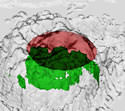
When Hurricane Erin was beating up the North Atlantic last year, NASA researchers decided to take its temperature. Using a special aircraft, researchers dropped eight sensors into the area round the storm’s eye, a place that contains the most powerful winds and warmest temperatures. Using this data, they were able to create a three-dimensional image of the complete inner core.
Last year, NASA researchers took the temperature of the eye of Hurricane Erin to determine how a hurricane?s warm center fuels the strength of storms. The new data is helping scientists understand the inner workings of hurricanes at very high altitudes, and will improve future hurricane forecasts.
The researchers found that the warmest portion around a hurricane?s eye is approximately 3.5 miles high and that area in the eye corresponds with falling pressure, which is what causes the winds to spiral inward at destructive speeds.
During September 2001 while flying over the North Atlantic Ocean, scientists aboard NASA?s ER-2 aircraft dropped eight sensors into the area around Hurricane Erin?s eye, containing the strongest thunderstorms and winds, and warmest temperatures. Variations in temperatures within a hurricane provide clues about the storm?s intensity. For example, a warm center marked by a large temperature contrast compared to the rest of the hurricane is a sign of a strong storm.
The sensors measured temperature, air pressure and winds as they fell through the hurricane and transmitted their data back to the ER-2 aircraft. For the first time, the data allowed scientists to create a comprehensive 3-dimensional image of the complete inner core (including the eyewall and the eye) of a hurricane, giving scientists a better look at how heat from warm, rising air spreads out in the storm?s center. The warm, humid, rising air is the key to a hurricane?s power. This rising air draws in air from the surface to take its place, and creates winds.
?Scientists can obtain a detailed look at a hurricane?s heat engine (the warm temperatures that power a storm) by combining the aircraft data with that from satellites such as NASA?s Tropical Rainfall Measurement Mission,? said Jeff Halverson, a scientist from NASA?s Goddard Space Flight Center, Greenbelt, Md., and the University of Maryland Baltimore County.
?The data from the sensors and the satellite have given us a view of the eye?s warm air, the rain clouds that warm the air through condensation, and the spiraling surface winds which in turn create the rain clouds. We have assembled all this data in a three dimensional rendition of the hurricane which is akin to taking a detailed ?CAT scan? of the storm,? Halverson said.
?We found that this storm had a very warm eye, from the ocean to the top of the lower atmosphere at around 10 miles altitude,? said Halverson. The warmest part of Erin?s eye was almost 21 degrees (Fahrenheit) warmer than the surrounding air, a dramatic difference from the air around it. Above 7.5 miles high, the eye?s temperature dropped quickly to the same temperature as the air outside the eye.
The warming temperatures within the hurricane?s eye make the air lighter, so air pressure eases on the surface and falls. When air is cold, the air molecules are dense, and air is heavier. The falling pressure in the hurricane?s eye is what creates swirling destructive winds.
The experiment also discovered that strong rising air currents in Erin caused the tropopause (top of the lower atmosphere) to ?bubble up? or bend, south of the eye?s center. This is indicative of the strength of Hurricane Erin, which was a Category 3 storm at this time.
There are five categories in which hurricanes are classified, the fifth being the most devastating. Category 3 hurricanes, such as Erin have winds between 111-130 mph, and can bring a storm surge of water (wind driven water above tide level) between 9-12 feet to shorelines.
Halverson will be presenting these findings at the AMS Hurricane and Tropical Meteorology Conference in San Diego, Calif. on Tuesday, April 30, 2002 at 9:00 a.m. Pacific time in a session titled ?Thermal Structure of Hurricane Erin?s Core Using Dropsonde Data From 68,000 Feet and Comparison with AMSU Satellite Measurements.?
Original Source: NASA News Release


