Layered deposits in Uzboi Vallis on Mars, as seen by the HiRISE camera on the Mars Reconnaissance Orbiter. Credit: NASA/JPL/University of Arizona.
We’ve posted several ‘flyover’ videos of Mars that use data from spacecraft. But this video might be the most spectacular and realistic. Created by filmmaker Jan Fröjdman from Finland, “A Fictive Flight Above Real Mars” uses actual data from the venerable HiRISE camera on board the Mars Reconnaissance Orbiter, and takes you on a 3-D tour over steep cliffs, high buttes, amazing craters, polygons and other remarkable land forms. But Fröjdman also adds a few features reminiscent of the landing videos taken by the Apollo astronauts. Complete with crosshatches and thruster firings, this video puts you on final approach to land on (and then take off from) Mars’ surface.
(Hit ‘fullscreen’ for the best viewing)
To create the video, Fröjdman used 3-D anaglyph images from HiRISE (High Resolution Science Imaging Experiment), which contain information about the topography of Mars surface and then processed the images into panning video clips.
Fröjdman told Universe Today he worked on this video for about three months.
“The most time consuming was to manually pick the more than 33,000 reference points in the anaglyph images,” he said via email. “Now when I count how many steps there were in total in the process, I come to seven and I needed at least 6 different kinds of software.”
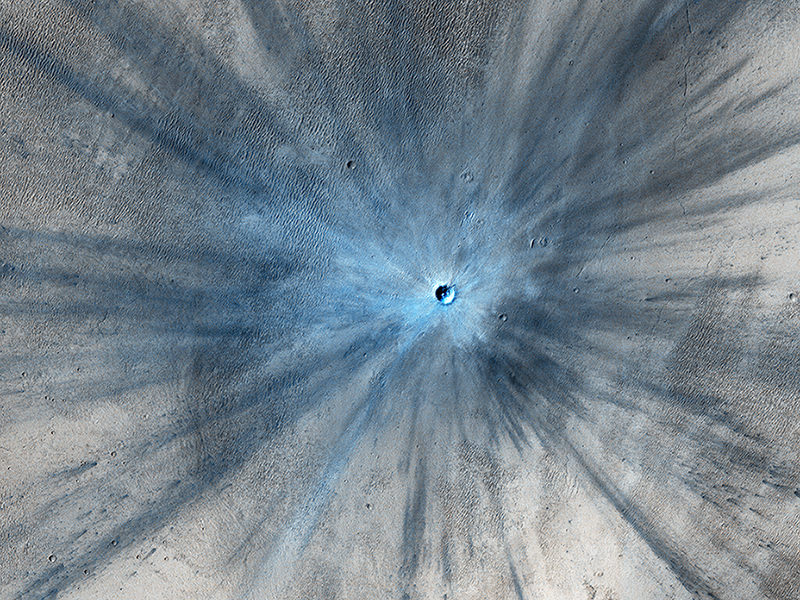
A new impact crater that was formed between July 2010 and May 2012, as seen by the HiRISE camera on the Mars Reconnaissance Orbiter. This image is part of “A Fictive Flight Above Real Mars” by Jan Fröjdman. Credit: NASA/JPL/University of Arizona.
Fröjdman, a landscape photographer and audiovisual expert, said he wanted to create a video that gives you the feeling “that you are flying above Mars looking down watching interesting locations on the planet,” he wrote on Vimeo. “And there are really great places on Mars! I would love to see images taken by a landscape photographer on Mars, especially from the polar regions. But I’m afraid I won’t see that kind of images during my lifetime.”
Between HiRISE and the Curiosity rover images, we have the next best thing to a human on Mars. But maybe one day…
Comet 41P glows green (left) and shows its true coma and just the hint of a stubby tail in the negative (red) image (right) from March 19th. Image credit and copyright: Hisayoshi Kato
Comet 41P Tuttle-Giacobini-Kresák glows green (left) and shows its true coma and just the hint of a stubby tail in the negative (red) image (right) from March 19th. Image credit and copyright: Hisayoshi Kato
Miss out on comet 45P Honda-Mrkos-Pajdušáková? Is Comet 2P Encke too low in the dawn sky for your current latitude? Well, the Universe is providing us northerners with another shot at a fine binocular comet, as 41P Tuttle-Giacobini-Kresák glides through Ursa Major this week.
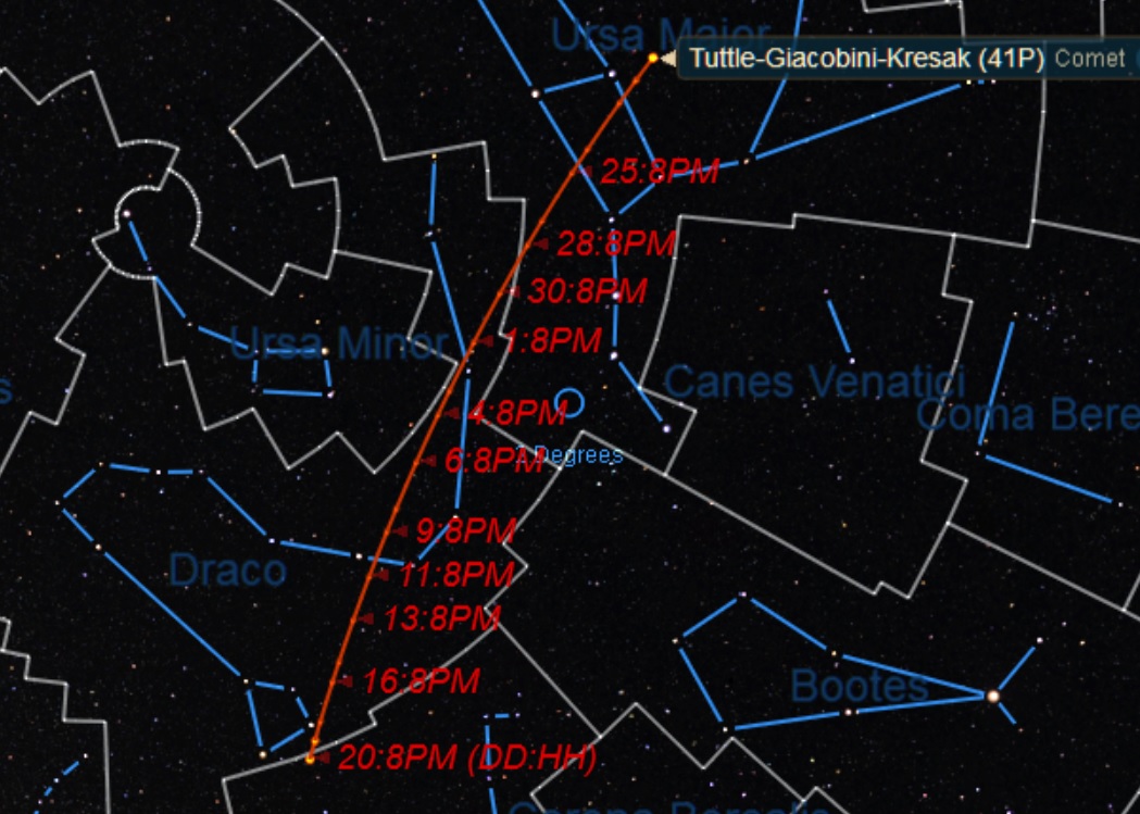
As seen from 30 degrees north, Comet 41P Tuttle-Giacobini-Kresák (sometimes called “Comet 41P” or “Comet TGK”) starts the last week of March about 40 degrees above the NE horizon at 9PM local. It then makes the plunge below 30 degrees elevation on April 1st for the same latitude at the same time. At its closest on April 5th, the comet will be moving at two degrees a day (the width of four Full Moons!) as seen from the Earth as it slides down through the snaky constellation of Draco.
The path of Comet 41P from March 20th through April 20th. Credit: Starry Night.
The comet reaches an elevation of 10 degrees for evening viewers around April 15th, and passes 10 degrees north of another up and coming binocular comet C/2015 V2 Johnson right around the same date. After early April, your odds get better to see Comet 41P Tuttle-Giacobini-Kresák high in the sky at its upper culmination past local midnight towards dawn.
There’s another reason to try and recover this comet this week, as the Moon is now a waning crescent headed towards New on March 28th. From there, the waxing Moon begins to interfere with cometary observations as it heads towards the Easter Full Moon on April 11th, pushing efforts to recover and follow the comet towards pre-dawn hours.
First discovered by astronomer Horace Tuttle 1858, the comet was independently recovered by Michel Giacobini in 1907 and L’ubor Kresák in 1951 and its periodic nature was uncovered.
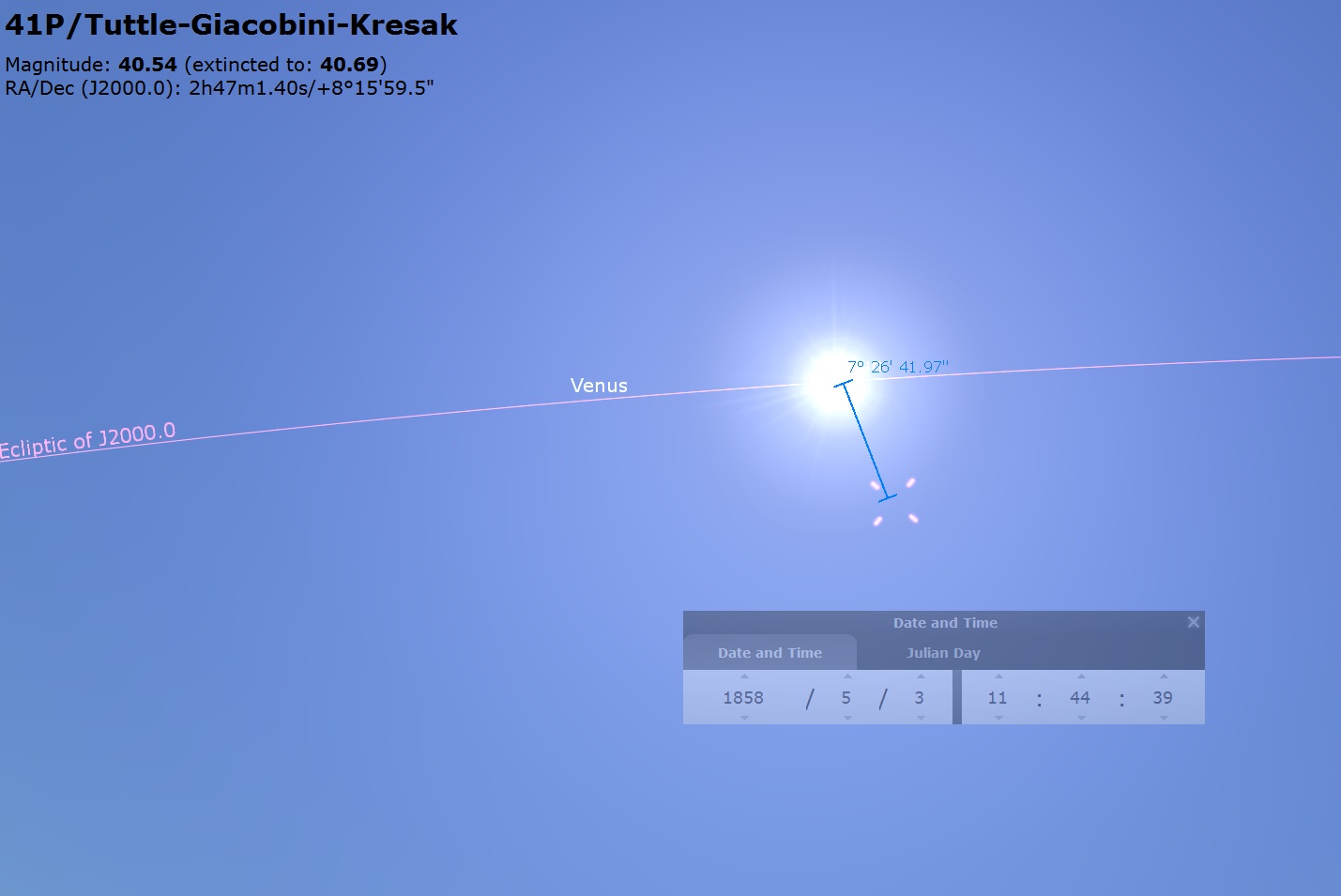
Note: We believe that the “May 3rd, 1858” date given for the discovery of this comet around ye ole Web is in fact, erroneous, as both Stellarium and Starry Night put the comet just a few degrees from the Sun on this date! Perhaps both programs are wrong looking that far back in time… but they’re both exactly wrong. Perhaps a bit of astronomical detective work is in order? More to come!
Due for a revision? Here’s the position of Comet 41P Tuttle-Giacobini-Kresák on the oft quoted discovery date of May 3rd, 1858… just 8 degrees from the Sun! Credit: Stellarium.
Orbiting the Sun once every 5.4 years, this is the 29th perihelion return of the comet since its discovery in 1858. The comet’s orbit takes it from 5.1 AU, out to near the orbit of Jupiter, to a perihelion just 0.13 AU outside the orbit of the Earth. This year’s passage is nearly as close as the comet can approach the Earth, with solar opposition also occurring on April 5th. The comet’s orbit is inclined about nine degrees to the ecliptic plane. Think of the comet zipping down over the northern hemisphere of the Earth, reaching perihelion as it heads from north to south, then headed back out over the southern hemisphere.
Currently at +9th magnitude, the comet should flirt with naked eye visibility of magnitude +6 in early April. This comet is also worth watching, as it’s known for periodic outbursts. Flashback to 1973, and Comet 41P Tuttle-Giacobini-Kresák made an easy naked eye apparition of +4. This is also the closest approach of Comet 41P Tuttle-Giacobini-Kresák near the Earth in our lifetimes, and the closest in the two century span from 1900 to 2100.
The projected light curve for Comet 41P Tuttle-Giacobini-Kresák. The pink line denotes perihelion, at the black dots mark recorded magnitude estimates. Adapted from Seiichi Yoshida’s Weekly Information About Bright Comets.
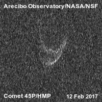
Arecibo did ping 41P Tuttle-Giacobini-Kresák in early March, but probably won’t image the comet near perihelion due to its northerly declination (Arecibo is only partially steerable). They did, however nab a great animation of the twin lobbed Comet 45P Honda-Mrkos-Pajdušáková on February 12th:
An amazing view: Comet 45P Honda-Mrkos-Pajušáková pinged by Arecibo radar last month. Credit: Arecibo/USRA
That makes two, bi-bulbous comets, if you include Comet 67P Churyumov-Gerasimenko. Are twin-lobbed comets in fact as common as comet-hunters with umlauts in their name?
Here are some key highlight events for Comet 41P Tuttle-Giacobini-Kresák to watch out for. Close passes are less than one degree unless otherwise noted:
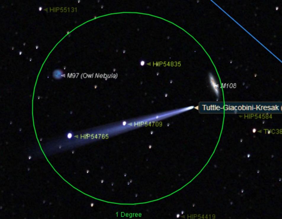
March 21st: Photo-op: passes between M108 and M97 the Owl Nebula March 29th: passes into Draco April 2nd: Passes near the 3.6 magnitude star Thuban (Alpha Draconis) April 5th: Passes just 0.15 AU (23.2 million kilometers) from the Earth at 13:30 UT. April 7th: passes just 22 degrees from the north celestial pole at declination 68 degrees north. April 11th: reaches perihelion at 1.05 AU (162.7 million kilometers) from the Sun. April 18th: passes the 2.7 magnitude star Rastaban (Beta Draconis) April 20th: passes into the constellation Hercules
The comet vs two Messier objects: the view on March 22nd at 12:00 UT. Credit: Starry Night
Observing comets is an exercise in patience, as that quoted magnitude is often smeared out over an extended area. Dark skies and a good star chart are key. I like to use binoculars when hunting for comets brighter than +10th magnitude, as it gives you a true (un-inverted both up/down and left to right) view, coupled with a generous field of view.
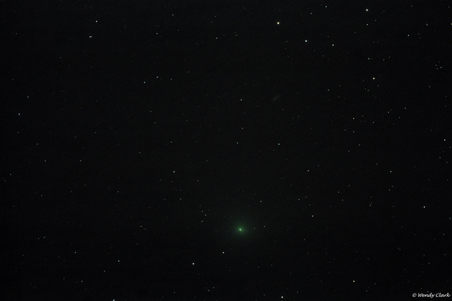
Comet 41P Tuttle-Giacobini-Kresák from March 15th. Image credit and copyright: Wendy Clark.
If Comet 41P Tuttle-Giacobini-Kresák outperforms into the +6th magnitude range or brighter, it could become a fine target to image with foreground objects. We’re already seeing some amazing images streaming in, with more to come as perihelion approaches.
Other binocular comets to watch for in 2017 include C/2015 ER61 PanSTARRS (May) and C/2015 V2 Johnson (June).
If Comet 41P Tuttle-Giacobini-Kresák performs at or above expectations (and if no great “comet(s) of the century show up!) it could be the best binocular comet of 2017. Don’t miss it!
-Send those images to Universe Today’s Flickr page.
-Be sure to read about the brightest comets of the year and more in our 2017 Astronomical Guide, free from Universe Today.
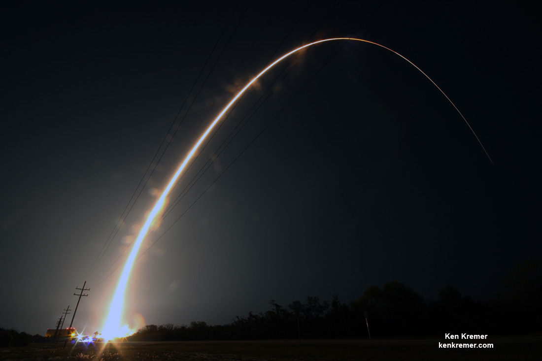
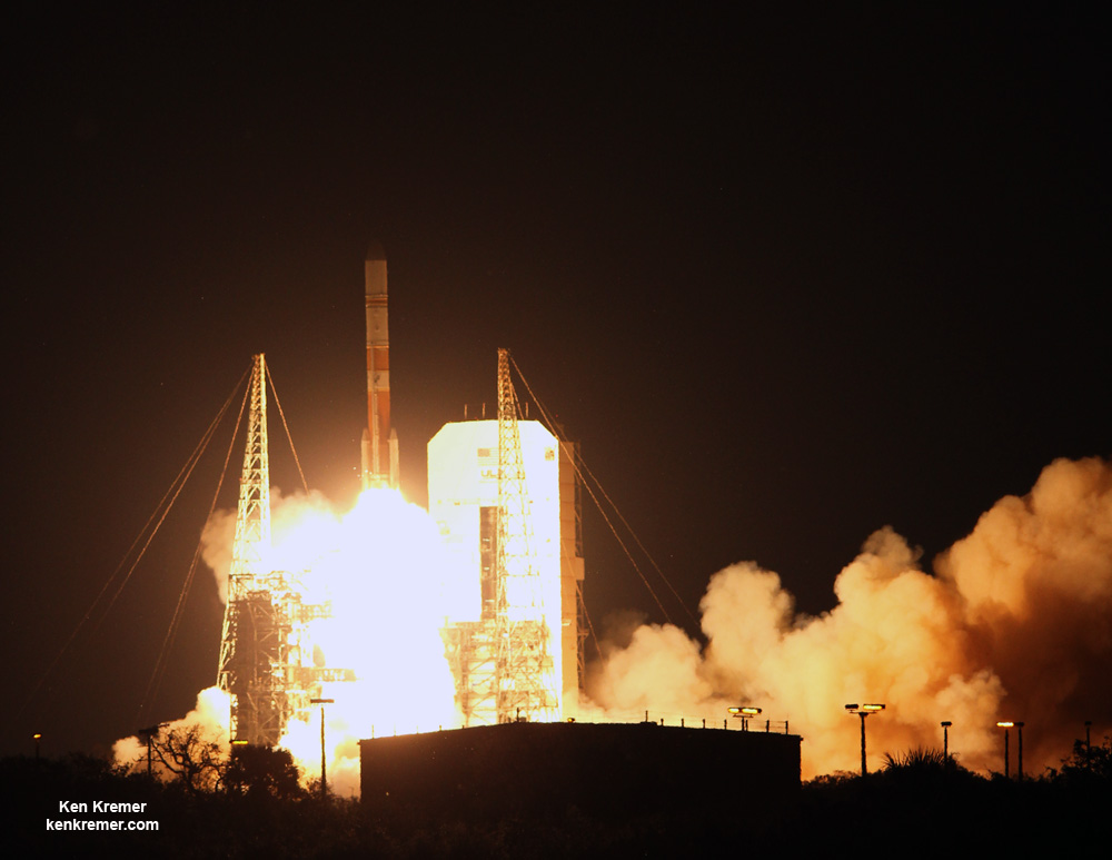
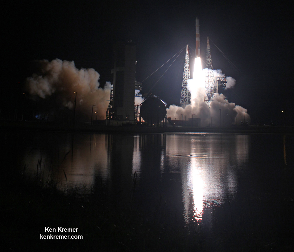
ULA Delta IV rocket streaks to orbit carrying the Wideband Global SATCOM (WGS-9) tactical communications satellite for the U.S. Air Force and international partners from Cape Canaveral Air Force Station, Fl, at 8:18 p.m. EDT on Mar. 18, 2017, in this long exposure photo taken on base. Credit: Ken Kremer/kenkremer.com
ULA Delta IV rocket streaks to orbit carrying the Wideband Global SATCOM (WGS-9) tactical communications satellite for the U.S. Air Force and international partners from Cape Canaveral Air Force Station, Fl, at 8:18 p.m. EDT on Mar. 18, 2017, in this long exposure photo taken on base. Credit: Ken Kremer/kenkremer.com
CAPE CANAVERAL AIR FORCE STATION, FL – On the 70th anniversary year commemorating the United States Air Force, a ULA Delta IV rocket put on a daunting display of nighttime rocket fire power shortly after sunset Saturday, March 19 – powering a high speed military communications satellite to orbit that will significantly enhance the targeting firepower of forces in the field; and was funded in collaboration with America’s strategic allies.
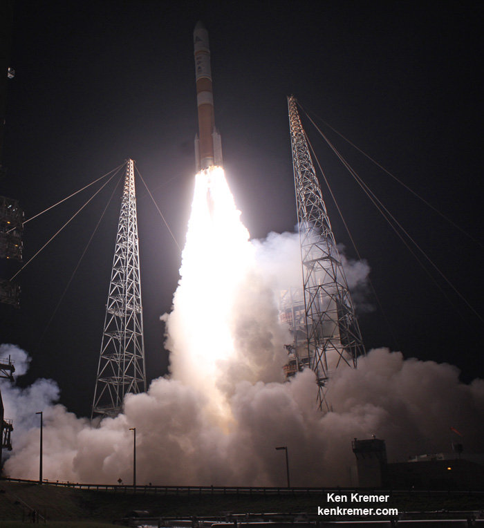
The next generation Wideband Global SATCOM-9 (WGS-9) military comsat mission for the U.S. Force lifted off atop a United Launch Alliance (ULA) Delta IV from Space Launch Complex-37 (SLC-37) on Saturday, March 18 at 8:18 p.m. EDT at Cape Canaveral Air Force Station, Florida.
The launch and separation of the payload form the Delta upper stage was “fully successful,” said Major General David D. Thompson, Vice Commander Air Force Space Command, Peterson Air Force Base, CO, to our media gaggle soon after launch at the press view site on base.
“The WGS-9 mission is key event celebrating the 70th anniversary of the U.S. Air Force as a separate service. The USAF was created two years after World War II ended.”
“The theme of this year is ‘breaking Barriers.’”
A United Launch Alliance (ULA) Delta IV rocket carrying the Wideband Global SATCOM (WGS-9) mission for the U.S. Air Force launches at 8:18 p.m. EDT on Mar. 18, 2017from Space Launch Complex-37 on Cape Canaveral Air Force Station, Fl. Credit: Ken Kremer/kenkremer.com
WGS-9 was delivered to a supersynchronous transfer orbit atop the ULA Delta IV Medium+ rocket.
The WGS-9 satellite was paid for by a six nation consortium that includes Canada, Denmark, Luxembourg, the Netherlands amd the United States. It joins 8 earlier WGS satellite already in orbit.
“WGS-9 was made possible by funding from our international partners,” Thompson emphasized.
Major General David D. Thompson, Vice Commander Air Force Space Command, Peterson Air Force Base, CO, and Brig. Gen. Wayne R. Monteith, Commander of the 45th Space Wing Commander and Eastern Range Director at Patrick Air Force Base, Fla, celebrate successful Wideband Global SATCOM (WGS-9) launch for the U.S. Air Force on ULA Delta IV from Cape Canaveral Air Force Station, Fl, on Mar. 18, 2017, with the media gaggle on base. Credit: Julian Leek
It is the ninth satellite in the WGS constellation that serves as the backbone of the U.S. military’s global satellite communications.
“WGS provides flexible, high-capacity communications for the Nation’s warfighters through procurement and operation of the satellite constellation and the associated control systems,” according to the U.S. Air Force.
“WGS provides worldwide flexible, high data rate and long haul communications for marines, soldiers, sailors, airmen, the White House Communication Agency, the US State Department, international partners, and other special users.”
Launch of USAF WGS-8 milsatcom on ULA Delta IV rocket from pad 37 on Cape Canaveral Air Force Station, Fl, on Mar. 18, 2017. Dawn Leek Taylor
WGS-9 also counts as the second of at least a trio of launches from the Cape this March – with the possibility for a grand slam fourth at month’s end – if all goes well with another SpaceX Falcon 9 launch from pad 39A.
Blastoff of ULA Delta IV rocket carrying the Wideband Global SATCOM (WGS-9) comsat to orbit for the U.S. Air Force from Space Launch Complex-37 on Cape Canaveral Air Force Station, Fl. Credit: Ken Kremer/kenkremer.com
The 217 foot tall Delta IV Medium+ rocket launched in the 5,4 configuration with a 5 meter diameter payload fairing that stands 47 feet tall, and 4 solid rocket boosters to augment the first stage thrust of the single common core booster.
The payload fairing was emblazoned with decals commemorating the 70th anniversary of the USAF, as well as Air Force, mission and ULA logos.
Orbital ATK manufactures the four solid rocket motors. The Delta IV common booster core was powered by an RS-68A liquid hydrogen/liquid oxygen engine producing 705,250 pounds of thrust at sea level.
A single RL10B-2 liquid hydrogen/liquid oxygen engine powered the second stage, known as the Delta Cryogenic Second Stage (DCSS).
The booster and upper stage engines are both built by Aerojet Rocketdyne. ULA constructed the Delta IV Medium+ (5,4) launch vehicle in Decatur, Alabama.
The DCSS will also serve as the upper stage for the maiden launch of NASA heavy lift SLS booster on the SLS-1 launch slated for late 2018. That DCSS/SLS-1 upper stage just arrived at the Cape last week – as I witnessed and reported here.
Saturday’s launch marks ULA’s 3rd launch in 2017 and the 118th successful launch since the company was formed in December 2006 as a joint venture between Boeing and Lockheed Martin.
The is the seventh flight in the Medium+ (5,4) configuration; all of which were for prior WGS missions.
ULA Delta IV rocket poised for sunset blastoff with the Wideband Global SATCOM (WGS-9) mission for the U.S. Air Force from Space Launch Complex-37 on Cape Canaveral Air Force Station, Fl, on Mar. 18, 2017. Credit: Ken Kremer/kenkremer.com
Stay tuned here for Ken’s continuing Earth and planetary science and human spaceflight news.
Learn more about USAF/ULA WGS satellite, SpaceX EchoStar 23 and CRS-10 launch to ISS, ULA SBIRS GEO 3 launch, EchoStar launch GOES-R launch, Heroes and Legends at KSCVC, OSIRIS-REx, InSight Mars lander, ULA, SpaceX and Orbital ATK missions, Juno at Jupiter, SpaceX AMOS-6, ISS, ULA Atlas and Delta rockets, Orbital ATK Cygnus, Boeing, Space Taxis, Mars rovers, Orion, SLS, Antares, NASA missions and more at Ken’s upcoming outreach events at Kennedy Space Center Quality Inn, Titusville, FL:
Mar 21-25: “USAF/ULA WGS satellite launch, SpaceX EchoStar 23, CRS-10 launch to ISS, ULA Atlas SBIRS GEO 3 launch, EchoStar 19 comsat launch, GOES-R weather satellite launch, OSIRIS-Rex, SpaceX and Orbital ATK missions to the ISS, Juno at Jupiter, ULA Delta 4 Heavy spy satellite, SLS, Orion, Commercial crew, Curiosity explores Mars, Pluto and more,” Kennedy Space Center Quality Inn, Titusville, FL, evenings
Close-up view of nose cone encapsulating the Wideband Global SATCOM (WGS-9) mission for the U.S. Air Force slated to launch from Space Launch Complex-37 on Cape Canaveral Air Force Station, Fl, on Mar. 18, 2017. Credit: Ken Kremer/kenkremer.com
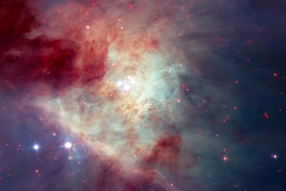
The stunning, shaped clouds of gas in the Orion Nebula make it beautiful, but also make it difficult to see inside of. This image of the Orion Nebula was captured by the Hubble Telescope. Image: NASA, ESA, M. Robberto (STScI/ESA) and
The Hubble Space Telescope Orion Treasury Project Team
It sometimes doesn’t take much to tear a family apart. A Christmas dinner gone wrong can do that. But for a family of stars to be torn apart, something really huge has to happen.
The dramatic break-up of a family of stars played itself out in the Orion Nebula, about 600 years ago. The Orion Nebula is one of the most studied objects in our galaxy. It’s an active star forming region, where much of the star birth is concealed behind clouds of dust. Advances in infrared and radio astronomy have allowed us to peer into the Nebula, and to watch a stellar drama unfolding.
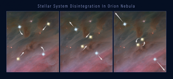
This three-frame illustration shows how a grouping of stars can break apart, flinging the members into space. Panel 1: members of a multiple-star system orbiting each other. Panel 2: two of the stars move closer together in their orbits. Panel 3: the closely orbiting stars eventually either merge or form a tight binary. This event releases enough gravitational energy to propel all of the stars in the system outward, as shown in the third panel. Credits: NASA, ESA, and Z. Levy (STScI)
Over the last few decades, observations showed the two of the stars in our young family travelling off in different directions. In fact, they were travelling in opposite directions, and moving at very high speeds. Much higher than stars normally travel at. What caused it?
Astronomers were able to piece the story together by re-tracing the positions of both stars back 540 years. All those centuries ago, around the same time that it was dawning on humanity that Earth revolved around the Sun instead of the other way around, both of the speeding stars were in the same location. This suggested that the two were part of a star system that had broken up for some reason. But their combined energy didn’t add up.
Now, the Hubble has provided another clue to the whole story, by spotting a third runaway star. They traced the third star’s path back 540 years and found that it originated in the same location as the others. That location? An area near the center of the Orion Nebula called the Kleinmann-Low Nebula.
This composite image of the Kleinmann-Low Nebula, part of the Orion Nebula complex, is composed of several pointings of the NASA/ESA Hubble Space Telescope in optical and near-infrared light. Infrared light allows to peer through the dust of the nebula and to see the stars therein. The revealed stars are shown with a bright red colour in the image. With this image, showing the central region of the Orion Nebula, scientists were looking for rogue planets and brown dwarfs. As side-effect they found a fast-moving runaway star. By ESA/Hubble, CC BY 4.0, https://commons.wikimedia.org/w/index.php?curid=57169218
The team behind these new results, led by Kevin Luhman of Penn State University, will release their findings in the March 20, 2017 issue of The Astrophysical Journal Letters.
“The new Hubble observations provide very strong evidence that the three stars were ejected from a multiple-star system,” said Luhman. “Astronomers had previously found a few other examples of fast-moving stars that trace back to multiple-star systems, and therefore were likely ejected. But these three stars are the youngest examples of such ejected stars. They’re probably only a few hundred thousand years old. In fact, based on infrared images, the stars are still young enough to have disks of material leftover from their formation.”
Young stars have a disk of gas and dust around them called a protoplanetary disk. Credit: NASA/JPL-Caltech
“The Orion Nebula could be surrounded by additional fledging stars that were ejected from it in the past and are now streaming away into space.” – Lead Researcher Kevin Luhman, Penn State University.
The three stars are travelling about 30 times faster than most of the Nebula’s other stellar inhabitants. Theory has predicted the phenomenon of these breakups in regions where newborn stars are crowded together. These gravitational back-and-forths are inevitable. “But we haven’t observed many examples, especially in very young clusters,” Luhman said. “The Orion Nebula could be surrounded by additional fledging stars that were ejected from it in the past and are now streaming away into space.”
The key to this mystery is the recently discovered third star. But this star, the so-called “source x”, was discovered by accident. Luhman is part of a team using the Hubble to hunt for free-floating planets in the Orion Nebula. A comparison of Hubble infrared images from 2015 with images from 1998 showed that source x had changed its position. This indicated that the star was moving at a speed of about 130,000 miles per hour.
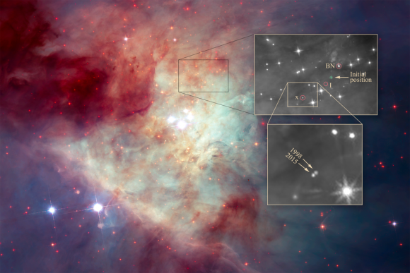
The image by NASA’s Hubble Space Telescope shows a grouping of young stars, called the Trapezium Cluster (center). The box just above the Trapezium Cluster outlines the location of the three stars. A close-up of the stars is top right. The birthplace of the multi-star system is marked “initial position.” Two of the stars — labeled BN, and “I,” for source I — were discovered decades ago. Source I is embedded in thick dust and cannot be seen. The third star, “x,” for source x, was recently discovered to have moved noticeably between 1998 and 2015, as shown in the inset image at bottom right. Credits: NASA, ESA, K. Luhman (Penn State University), and M. Robberto (STScI)
Luhmann then re-traced source x’s path and it led to the same position as the other 3 runaway stars 540 years ago: the Kleinmann-Low Nebula.
According to Luhmann, the three stars were most likely ejected from their system due to gravitational fluctuations that should be common in a high-population area of newly-born stars. Two of the stars can come very close together, either forming a tight binary system or even merging. That throws the gravitational parameters of the system out of whack, and other stars can be ejected. The ejection of those stars can also cause fingers of matter to flow out of the system.
As we get more powerful telescopes operating in the infrared, we should be able to clarify exactly what happens in areas of intense star formation like the Orion Nebula and its embedded Kleinmann-Low Nebula. The James Webb Space Telescope should advance our understanding greatly. If that’s the case, then not only will the details of star birth and formation become much clearer, but so will the break up of young families of stars.
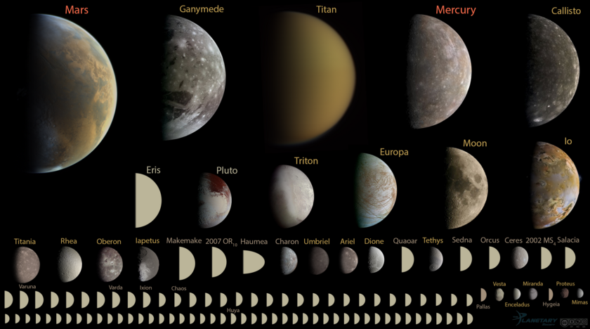
A new definition of what is a planet would mean there are at least 110 planets in our Solay System. Image Courtesy of Emily Lakdawalla of the Planetary Society, Data from NASA / JPL, JHUAPL/SwRI, SSI, and UCLA / MPS / DLR / IDA, processed by Gordan Ugarkovic, Ted Stryk, Bjorn Jonsson, Roman Tkachenko, and Emily Lakdawalla. https://creativecommons.org/licenses/by-nc-sa/3.0/
Pluto’s status as a non-planet may be coming to an end. Professor Mike Brown of Caltech ended Pluto’s planetary status in 2006. But now, Kirby Runyon, a doctoral student at Johns Hopkins University, thinks it’s time to cancel that demotion and restore it as our Solar System’s ninth planet.
Pluto’s rebirth as a planet is not just all about Pluto, though. A newer, more accurate definition of what is and what is not a planet is needed. And if Runyon and the other people on the team he leads are successful, our Solar System would have more than 100 planets, including many bodies we currently call moons. (Sorry elementary school students.)
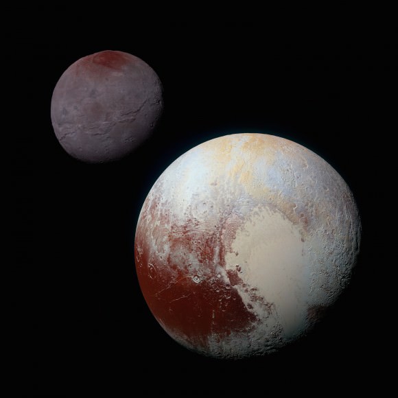
This composite of enhanced color images of Pluto (lower right) and Charon (upper left), was taken by NASA’s New Horizons spacecraft as it passed through the Pluto system on July 14, 2015. Credits: NASA/JHUAPL/SwRI
In 2006, the International Astronomical Union (IAU) changed the definition of what a planet is. Pluto’s demotion stemmed from discoveries in the 1990’s showing that it is actually a Kuiper Belt Object (KBO). It was just the first KBO that we discovered. When Pluto was discovered by Clyde Tombaugh in 1930, and included as the ninth planet in our Solar System, we didn’t know much about the Kuiper Belt.
But in 2005, the dwarf planet Eris was discovered. It was like Pluto, but 27% more massive. This begged the question, Why Pluto and not Eris? The IAU struck a committee to look into how planets should be defined.
In 2006, the IAU had a decision to make. Either expand the definition of what is and what is not a planet to include Eris and other bodies like Ceres, or shrink the definition to omit Pluto. Pluto was demoted, and that’s the way it’s been for a decade. Just enough time to re-write text books.
But a lot has happened since then. The change to the definition of planet was hotly debated, and for some, the change should never have happened. Since the New Horizons mission arrived at Pluto, that debate has been re-opened.
“A planet is a sub-stellar mass body that has never undergone nuclear fusion…” – part of the new planetary definition proposed by Runyon and his team.
The group behind the drive to re-instate Pluto have a broader goal in mind. If the issue of whether Pluto is or is not a planet sounds a little pedantic, it’s not. As Runyon’s group says on their poster to be displayed at the upcoming conference, “Nomenclature is important as it affects how we compare, think, and communicate about objects in nature.”
Runyon’s team proposes a new definition of what is a planet, focused on the geophysics of the object: “A planet is a sub-stellar mass body that has never undergone nuclear fusion and that has enough gravitation to be round due to hydrostatic equilibrium regardless of its orbital parameters.”
The poster highlights some key points around their new planetary definition:
Emphasizes intrinsic as opposed to extrinsic properties.
Can be paraphrased for younger students: “Round objects in space that are smaller than stars.”
The geophysical definition is already in use, taught, and included in planetological glossaries.
There’s no need to memorize all 110 planets. Teach the Solar Systems zones and why different planet types formed at different distances from the Sun.
Their proposal makes a lot of sense, but there will be people opposed to it. 110 planets is quite a change, and the new definition is a real mouthful.
“They want Pluto to be a planet because they want to be flying to a planet.” – Prof. Mike Brown, from a BBC interview, July 2015.
Mike Brown, the scientist behind Pluto’s demotion, saw this all coming when New Horizons reached the Pluto system in the Summer of 2015. In an interview with the BBC, he said “The people you hear most talking about reinstatement are those involved in the (New Horizons) mission. It is emotionally difficult for them.”
Saying that the team behind New Horizons find Pluto’s status emotionally difficult seems pretty in-scientific. In fact, their proposed new definition seems very scientific.
This image from New Horizons shows the true nature of Pluto. What for a long time was just a blurry, round, blob in space, was revealed as a geologically active planet with a seasonal atmosphere. Image: NASA/JPL/New Horizons
There may be an answer to all of this. The term “classical planets” might be of some use. That term could include our 9 familiar planets, the knowledge of which guided much of our understanding and exploration of the Solar System. But it’s a fact of science that as our understanding of something grows more detailed, our language around it has to evolve to accommodate. Look at the term planetary nebula—still in use long after we know they have nothing to do with planets—and how much confusion it causes.
“It is official without IAU approval, partly via usage.” – Runyon and team, on their new definition.
In the end, it may not matter whether the IAU is convinced by Runyon’s proposed new definition. As their poster states, “As a geophysical definition, this does not fall under the domain of the IAU, and is an alternate and parallel definition that can be used by different scientists. It is “official” without IAU approval, partly via usage.”
It may seem pointless to flip-flop back and forth about Pluto’s status as a planet. But there are sound reasons for updating definitions based on our growing knowledge. We’ll have to wait and see if the IAU agrees with that, and whether or not they adopt this new definition, and the >100 planet Solar System.
You can view Runyon and team’s poster here.
You can view Emily Lakdawalla’s image of round objects in our Solar System here.
You can read the IAU’s definition of a planet here.
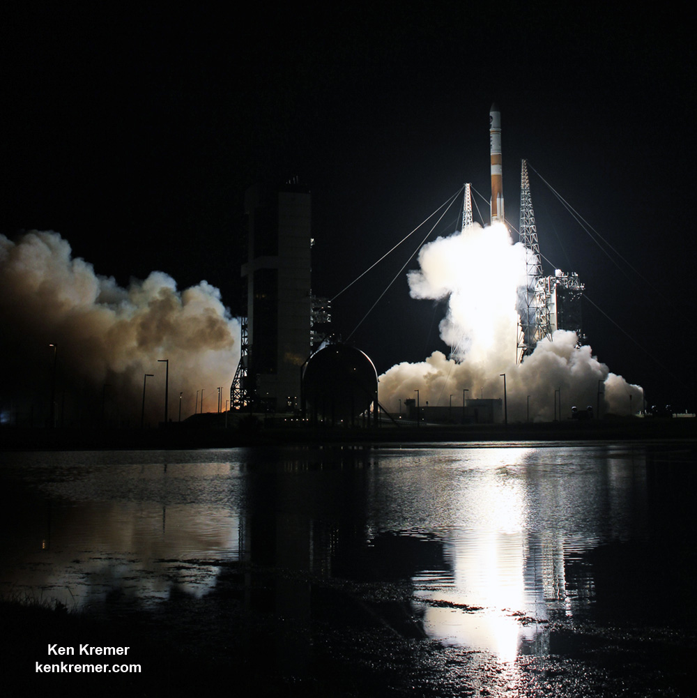
ULA Delta IV rocket poised for sunset blastoff with the Wideband Global SATCOM (WGS-9) mission for the U.S. Air Force from Space Launch Complex-37 on Cape Canaveral Air Force Station, Fl, on Mar. 18, 2017. Credit: Ken Kremer/kenkremer.com
ULA Delta IV rocket poised for sunset blastoff with the Wideband Global SATCOM (WGS-9) mission for the U.S. Air Force from Cape Canaveral Air Force Station, Fl, on Mar. 18, 2017. Credit: Ken Kremer/kenkremer.com
CAPE CANAVERAL AIR FORCE STATION, FL – As sunset dawns on the venerable Delta rocket program, the sole Delta slated to launch from the Cape this year is set to dazzle at sunset tonight, Saturday, March 18.
And the launch site is drenched with brilliant blue skies this afternoon as I watched the Delta rocket exposed to the heavens as the mobile service tower rolled away from on site at pad 37.
Florida’s Space Coast will light up with a spectacular sunset burst of fire and fury as a United Launch Alliance (ULA) Delta rocket roars to space with a super advanced tactical satcom for the U.S. Air Force that will provide a huge increase in communications bandwidth for American forces around the globe.
Blastoff of the Wideband Global SATCOM (WGS-9) mission for the U.S. Air Force is slated for 7:44 p.m. EDT on Saturday, Mar. 18, 2017 from Space Launch Complex-37 at Cape Canaveral Air Force Station, Florida.
Close-up view of nose cone encapsulating the Wideband Global SATCOM (WGS-9) mission for the U.S. Air Force slated to launch from Cape Canaveral Air Force Station, Fl, on Mar. 18, 2017. Credit: Ken Kremer/kenkremer.com
WGS-9 will be delivered to a supersynchronous transfer orbit atop a ULA Delta IV Medium+ rocket.
Thus ‘March Launch Madness’ continues unabated tonight – with a dizzying pace of launches.
So it’s past time to ‘get your ass to the Cape’ – because the weather is glorious in central Florida. And … a Atlas rocket is slated to launch in only five or six days – late next week! in six next Friday.
Saturday’s sunset launch window runs for one hour and 15 minutes from 7:44-8:59 p.m. EDT.
You can watch the Delta launch live on a ULA webcast. The live launch broadcast will begin approximately 20 minutes prior to liftoff at 7:24 p.m. EST here:
http://www.ulalaunch.com/webcast.aspx
The weather forecast for Saturday, Mar. 18, calls for a 90 percent chance of acceptable ‘GO’ weather conditions at launch time.
The primary concern is for cumulus clouds.
In case of a scrub for any reason the chances for a favorable launch dip just slightly to 80% GO on Sunday, March 19.
WGS-9 and her two sisters are the most powerful US Air Force military communications satellite ever built.
WGS-8 was launched on a Delta in December 2016.
A United Launch Alliance (ULA) Delta IV rocket carrying the WGS-8 mission lifts off from Space Launch Complex-37 at 6:53 p.m EDT on Dec. 7, 2016 from Cape Canaveral Air Force Station, Fla. Credit: Ken Kremer/kenkremer.com
It is the ninth satellite in the WGS constellation that serves as the backbone of the U.S. military’s global satellite communications.
“WGS provides flexible, high-capacity communications for the Nation’s warfighters through procurement and operation of the satellite constellation and the associated control systems,” according to the U.S. Air Force.
“WGS provides worldwide flexible, high data rate and long haul communications for marines, soldiers, sailors, airmen, the White House Communication Agency, the US State Department, international partners, and other special users.”
United Launch Alliance (ULA) Delta IV rocket carrying the WGS-8 mission for the U.S. Air Force launches at 6:53 p.m EDT on Dec. 7, 2016 from Cape Canaveral Air Force Station, Fl. Credit: Ken Kremer/kenkremer.com
The 217 foot tall Delta IV Medium+ rocket will launch in the 5,4 configuration with a 5 meter diameter payload fairing and 4 solid rocket boosters to augment the first stage.
The is the seventh flight in the Medium+ (5,4) configuration; all of which were for prior WGS missions.
WGS-9 also counts as the first of at least a trio of launches from the Cape this March- with the possibility for a grand slam fourth at month’s end – if all goes well with another SpaceX Falcon 9 launch from pad 39A.
Stay tuned here for Ken’s continuing Earth and planetary science and human spaceflight news.
Learn more about USAF/ULA WGS satellite, SpaceX EchoStar 23 and CRS-10 launch to ISS, ULA SBIRS GEO 3 launch, EchoStar launch GOES-R launch, Heroes and Legends at KSCVC, OSIRIS-REx, InSight Mars lander, ULA, SpaceX and Orbital ATK missions, Juno at Jupiter, SpaceX AMOS-6, ISS, ULA Atlas and Delta rockets, Orbital ATK Cygnus, Boeing, Space Taxis, Mars rovers, Orion, SLS, Antares, NASA missions and more at Ken’s upcoming outreach events at Kennedy Space Center Quality Inn, Titusville, FL:
Mar 21-25: “USAF/ULA WGS satellite launch, SpaceX EchoStar 23, CRS-10 launch to ISS, ULA Atlas SBIRS GEO 3 launch, EchoStar 19 comsat launch, GOES-R weather satellite launch, OSIRIS-Rex, SpaceX and Orbital ATK missions to the ISS, Juno at Jupiter, ULA Delta 4 Heavy spy satellite, SLS, Orion, Commercial crew, Curiosity explores Mars, Pluto and more,” Kennedy Space Center Quality Inn, Titusville, FL, evenings
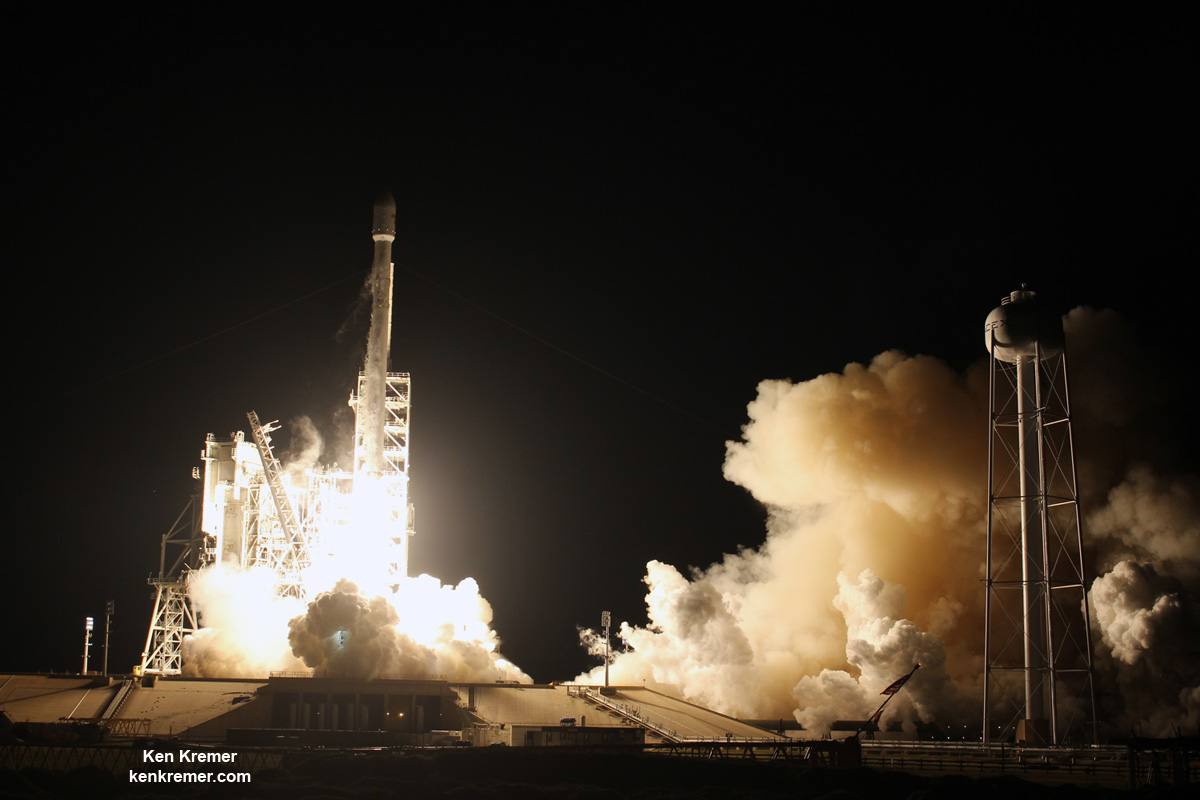
Blastoff of SpaceX Falcon 9 with EchoStar XXIII TV satellite for Brazil from Launch Complex 39A at NASA’s Kennedy Space Center in Florida on March 16 at 2:00 a.m. EDT. Photo from camera at the pad perimeter. Credit: Ken Kremer/Kenkremer.com
Blastoff of SpaceX Falcon 9 with EchoStar XXIII TV satellite for Brazil from Launch Complex 39A at NASA’s Kennedy Space Center in Florida on March 16 at 2:00 a.m. EDT. Photo from camera at the pad perimeter. Credit: Ken Kremer/Kenkremer.com
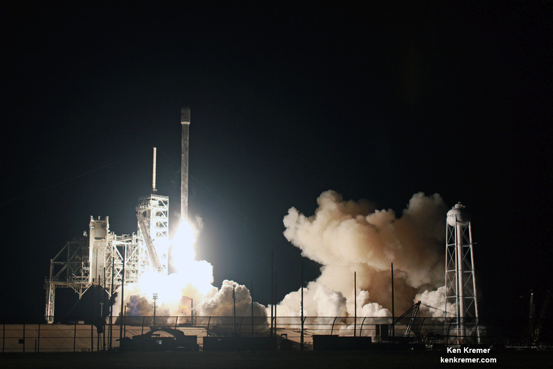
KENNEDY SPACE CENTER, FL – The opening volley of March Launch Madness started brilliantly as showcased by stunning imagery of the inaugural nighttime launch of a SpaceX Falcon 9 off historic pad 39A under moonlit skies along the Florida Space Coast on Thursday, March 15.
The 229 foot tall Falcon 9 rocket thundered to life at 2:00 a.m. EDT Thursday, March 16 on a commercial liftoff from Launch Complex 39A on NASA’s Kennedy Space Center and successfully delivered the high capacity EchoStar XXIII TV broadcast satellite to geosynchronous orbit for Brazil.
Check out the expanding spectacular gallery of launch photos and videos gathered from my space journalist colleagues, myself and spectators ringing the space coast.
Besides being the first night launch of a Falcon 9 from pad 39A, the mission also goes down as the first fully commercial launch from pad 39A.
Overall the EchoStar XXIII launch counts as only the second Falcon 9 ever to blast off from pad 39A.
The inaugural Falcon 9 blastoff successfully took place last month on Feb. 19 on a contracted cargo resupply mission for NASA that delivered over 2.7 tons of science experiments, crew supplies and research gear to the International Space Station (ISS) on the SpaceX CRS-10 Dragon spaceship – as I reported here.
SpaceX’s billionaire CEO Elon Musk leased historic pad 39A from NASA back in April 2014 for launches of the firms Falcon 9 and Falcon Heavy carrying both robotic vehicles as well as humans on missions to low Earth orbit, the Moon and ultimately the Red Planet.
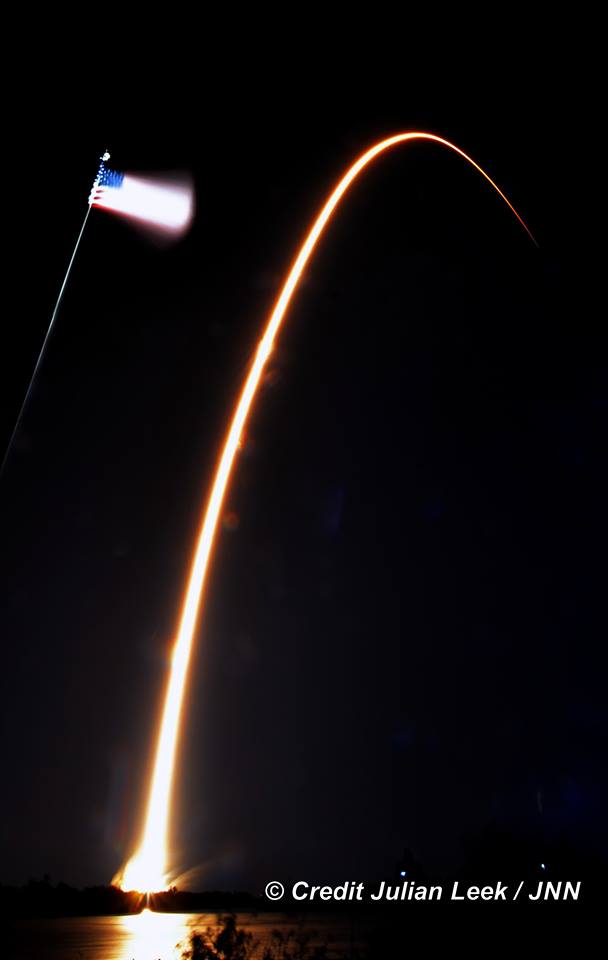
Streak shot of SpaceX Falcon 9 carrying EchoStar 23 TV satellite to orbit from pad 39A at the Kennedy Space Center in Florida on March 16 at 2:00 a.m. EDT, as seen from the KSC press site. Credit: Julian Leek
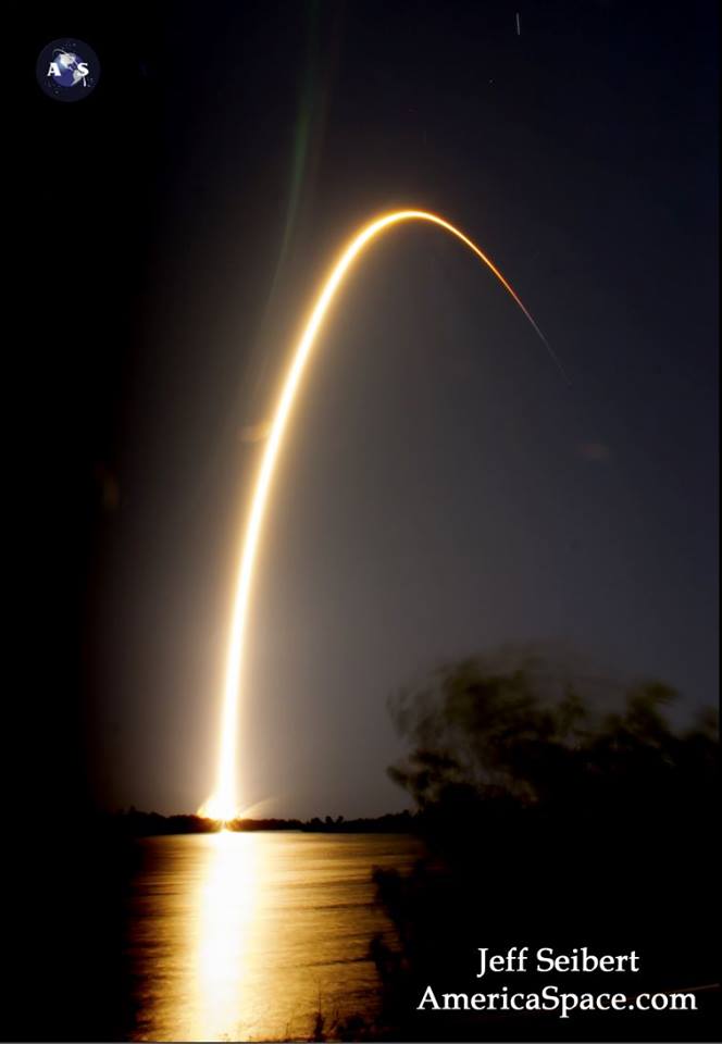
Watch this video compilation from Jeff Seibert:
Video Caption: Echostar-23 launch on a Falcon 9 rocket. The launch of the Echostar-23 satellite is the first commercial launch to take place from historic Pad 39A. Credit: Jeff Seibert
After a short delay due to wind issues, the Falcon 9’s nine Merlin 1D first stage engines ignited at 2:00 a.m. EDT March 16, generating 1.7 million pounds of liftoff thrust to propel the commercial EchoStar 23 telecommunications satellite off pad 39A and on its way to a Geostationary Transfer Orbit (GTO) for EchoStar Corporation.
The satellite was deployed approximately 34 minutes after launch.
If all goes well, March features a triple header of launches with launch competitor and arch rival United Launch Alliance (ULA) planning a duo of nighttime blastoffs from their Delta and Atlas rocket families.
With Falcon away, the launch dates have been rescheduled for Saturday, March 18 and Friday, March 24 respectively.
Indeed the potential for a grand slam of launches also exists with another Falcon 9 blastoff at the very end of this month – if all goes well. But first we have to get through the Delta and Atlas launches and deal with finicky Florida weather.
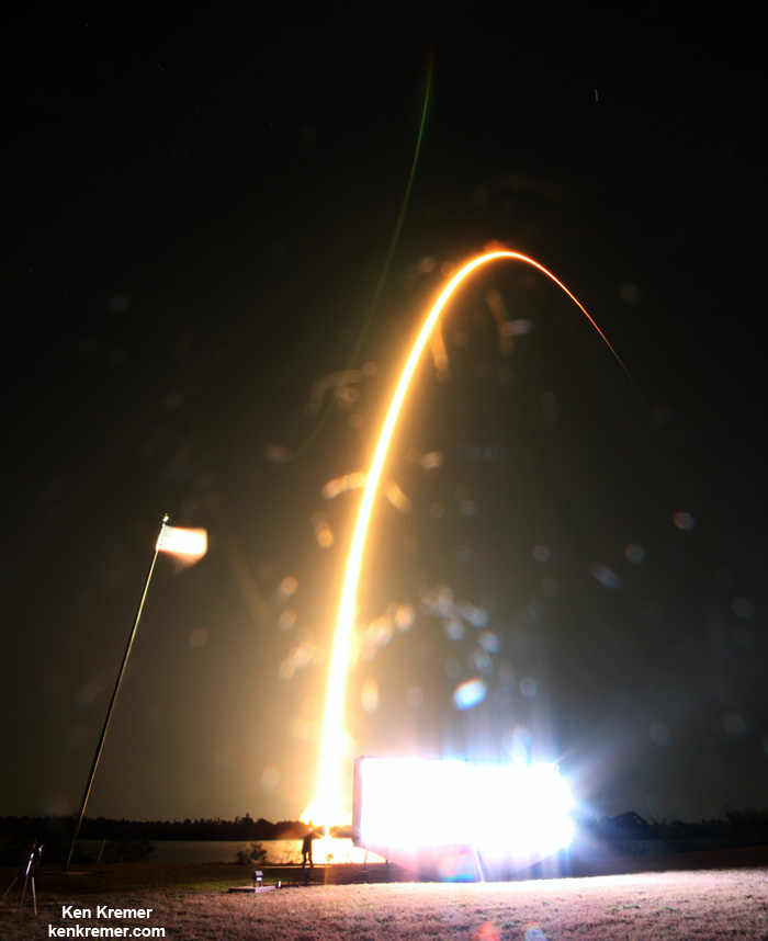
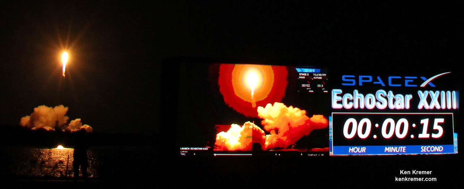
SpaceX Falcon 9 rocket streaks to orbit with EchoStar XXIII TV satellite in this long exposure photo taken in front of NASA’s countdown clock under moonlit skies at the Kennedy Space Center in Florida on March 16 at 2:00 a.m. EDT. Credit: Ken Kremer/Kenkremer.com
SpaceX announced that this was the last launch of an expendable Falcon 9.
Streak shot of SpaceX Falcon 9 carrying EchoStar 23 TV satellite to orbit from pad 39A at the Kennedy Space Center in Florida on March 16 at 2:00 a.m. EDT, as seen from the turn basin at the KSC press site. Credit: Jeff Seibert
Stay tuned here for Ken’s continuing Earth and Planetary science and human spaceflight news.
Blastoff of SpaceX Falcon 9 with EchoStar 23 TV satellite from Launch Complex 39A at NASA’s Kennedy Space Center in Florida on March 16 at 2:00 a.m. EDT. Photo from camera inside the pad perimeter. Credit: Ken Kremer/Kenkremer.com Composite panoramic view of seaside Launch Complex 39A with SpaceX hangar and Falcon rocket 9 raised vertical to deliver the EchoStar 23 telecom satellite to geostationary orbit overnight March 16, 2017. Pad 39B at center. Credit: Ken Kremer/Kenkremer.comThe SpaceX Falcon 9 launches the EchoStar 23 telecomsat from historic Launch Complex 39A with countdown clock in foreground at NASA’s Kennedy Space Center as display shows liftoff progress to geosynchronous orbit after post midnight blastoff on March 16 at 2:oo a.m. EDT. Credit: Ken Kremer/Kenkremer.com Liftoff of SpaceX Falcon 9 with EchoStar XXIII as seen through the trees from a house in Titusville, FL. Credit: Wesley BaskinLiftoff of SpaceX Falcon 9 with EchoStar XXIII as seen through the trees from a house in Titusville, FL. Credit: Wesley Baskin
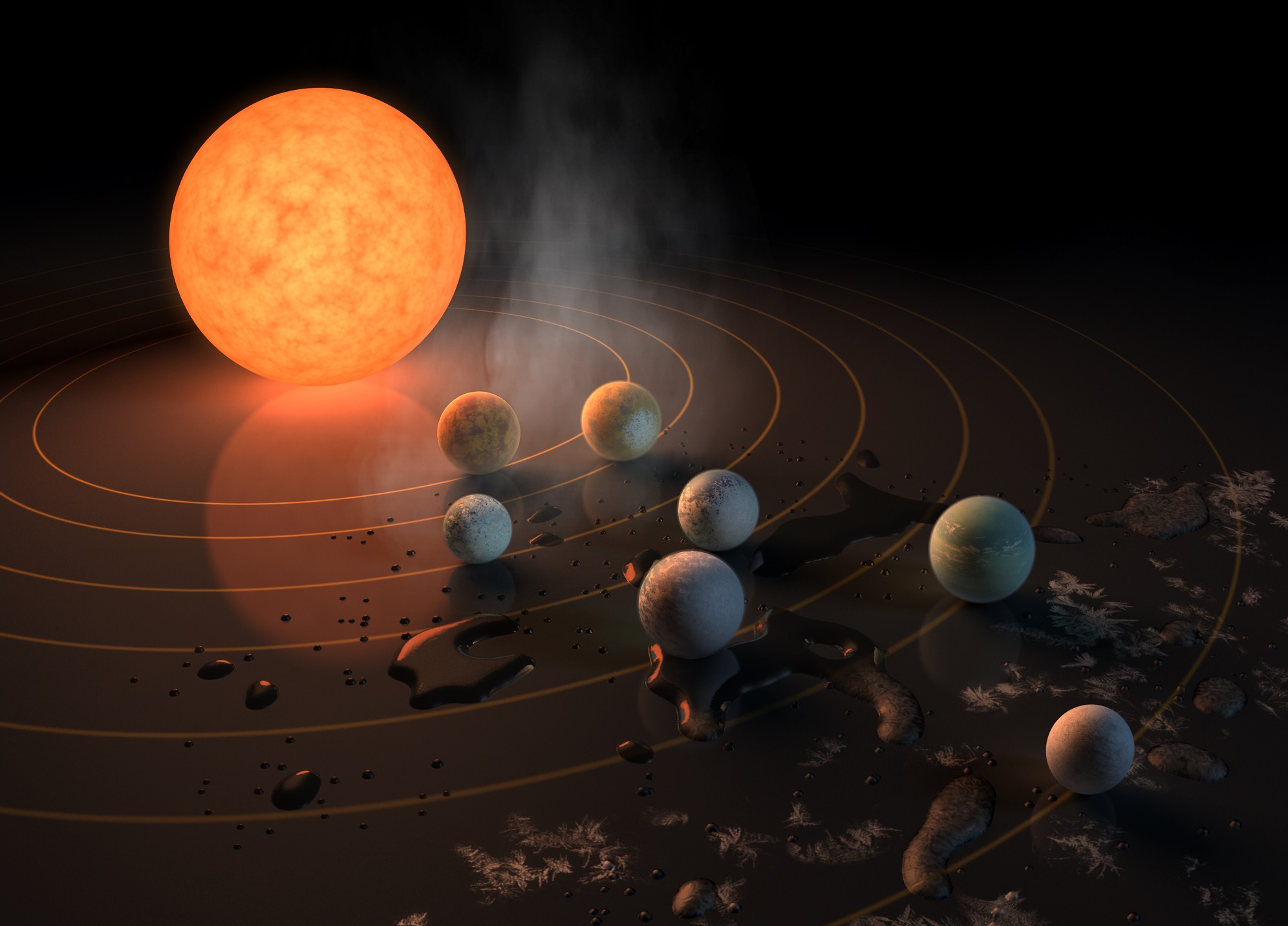
Artist's concept of the TRAPPIST-1 star system, an ultra-cool dwarf that has seven Earth-size planets orbiting it. We're going to keep finding more and more solar systemsl like this, but we need observatories like WFIRST, with starshades, to understand the planets better. Credits: NASA/JPL-Caltech
In case you haven’t heard, some new potentially habitable planets were discovered, and they’re named after beer. To celebrate two of our favorite things finally coming together, Forbidden Brewing Co. welcomes local space expert Fraser Cain for an evening of space talk, beer, and pizza.
The newly discovered planets are called the TRAPPIST-1 planets, and they’re named after a type of beer brewed by Belgian Trappist Monks. The knowledgeable and entertaining Fraser Cain will host the evening, and will answer your questions about these fascinating planets and their star.
Whether you’re just curious, or you’re a bona fide astronomy nerd, this is a great opportunity to rub shoulders with others who share your curiosity. And your love of beer.
A mug of beer. Mmmmm… Image: http://twitter.com/aizek https://creativecommons.org/licenses/by/2.0/
Fraser Cain is a lifelong Comox Valley resident, and is the publisher of Universe Today, a popular space and astronomy website. In honor of the planets-named-after-Belgian-beer, Forbidden Brewing will be serving their Belgian Saison, (which we can confirm as a great beer!) There will also be food available.
This fun and fact-filled evening will be held at the Forbidden Brewing Company on Cliffe Avenue in Courtenay, Vancouver Island, BC, on March 29th at 6:30 PM.
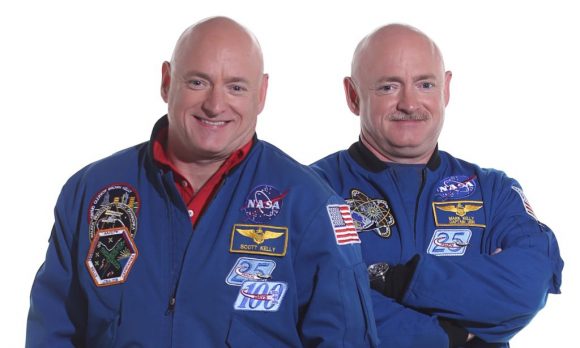
NASA is beginning to integrate the results of its twin study on astronauts Mark and Scott Kelly. Image: NASA
People who plan and conduct space missions never tire of telling us how hard it is to do things in space.
Our next big goal is getting humans to Mars, and establishing a colony there. There are a multitude of technical and engineering hurdles to be overcome, but we think we can do it.
But the other side of the coin is the physiological hurdles to be overcome. Those may prove to be much more challenging to deal with. NASA’s twins study is poised to add an enormous amount of data to our growing body of knowledge on the effects of space travel on human beings.
NASA’s astronaut twins, Scott Kelly (l) and Mark Kelly (r). Image: NASA
Astronaut twins Scott and Mark Kelly are the basis of NASA’s study. Scott spent a year in space, returning to Earth on March 1st 2016, after spending 340 days aboard the ISS. Mark, himself a retired astronaut, remained on Earth during Scott’s year in space, providing a baseline for studying the effects on the human body of such a prolonged period of time away from Earth.
In February of 2016, NASA released preliminary results of the study. Now, the team studying the results of the twins study has started integrating the data. The way they’re doing this sets it apart from other studies.
“No one has ever looked this deeply at a human subject and profiled them in this detail.” – Tejaswini Mishra, Ph.D., Stanford University School of Medicine.
Typically, individual studies are released to appropriate journals more or less one at a time. But in the twins study, the data will be integrated and summarized before individual papers are published on separate themes. The idea is that taken together, their impact on our understanding of prolonged time in space will be much greater.
“The beauty of this study is when integrating rich data sets of physiological, neurobehavioral and molecular information, one can draw correlations and see patterns,” said Tejaswini Mishra, Ph.D., research fellow at Stanford University School of Medicine, who is creating the integrated database, recording results and looking for correlations. “No one has ever looked this deeply at a human subject and profiled them in this detail. Most researchers combine maybe two to three types of data but this study is one of the few that is collecting many different types of data and an unprecedented amount of information.”
“Each investigation within the study complements the other.” – Brinda Rana, Ph.D., U of C, San Diego School of Medicine
Mike Snyder, Ph.D, is the head of a team of people at Stanford that will work to synthesize the data. There are roughly three steps in the overall process:
Individual researchers in areas like cognition, biochemistry, and immunology will analyze and compile their data then share their results with the Stanford team.
The Stanford team will then further integrate those results into larger data sets.
Those larger data sets will then be reviewed and analyzed to confirm and modify the initial findings.
“There are a lot of firsts with this study and that makes it exciting,” said Brinda Rana, Ph.D., associate professor of psychiatry, University of California San Diego School of Medicine. “A comparative study with one twin in space and one on Earth has never been done before. Each investigation within the study complements the other.”
NASA compares the twins study, and the new integrated method of handling all the results, to conducting a symphony. Each study is like an instrument, and instead of each one playing a solo, they will be added into a greater whole. The team at Stanford is like the conductor. If you’ve ever listened to an orchestra, you know how powerful that can be.
“The human systems in the body are all intertwined which is why we should view the data in a holistic way,” said Scott M. Smith, Ph.D., NASA manager for nutritional biochemistry at the Johnson Space Center. He conducts biochemical profiles on astronauts and his research is targeted to specific metabolites, end products of various biological pathways and processes.
“It is a more comprehensive way to conduct research.” – Chris Mason, Ph.D., associate professor, Department of Physiology and Biophysics Weill Cornell Medicine
Chris Mason Ph.D., at Weill Cornell Medicine said, “Both the universe and the human body are complicated systems and we are studying something hard to see. It’s like having a new flashlight that illuminates the previously dark gears of molecular interactions. It is a more comprehensive way to conduct research.”
Scientists involved with the twins study are very clearly excited about this new approach. Having twin astronauts is an extraordinary opportunity, and will advance our understanding of spaceflight on human physiology enormously.
“There is no doubt, the learnings from integrating our data will be priceless,” said Emmanuel Mignot, M.D., Ph.D., director of Center for Sleep Science and Medicine, Stanford University School of Medicine. He studies the immune system and is enthusiastic to study specific immune cell populations because many of the other immune studies focus only on general factors.
A summary of the early results should be out by early 2018, or possible late 2017. Individual papers on more detailed themes will follow shortly.
Special Guest:
Stuart McNeill is the the Community Engagement specialist in charge of Family Programs and Demonstrations at the Intrepid Sea, Air & Space Museum. Check out their membership site here.
We use a tool called Trello to submit and vote on stories we would like to see covered each week, and then Fraser will be selecting the stories from there. Here is the link to the Trello WSH page (http://bit.ly/WSHVote), which you can see without logging in. If you’d like to vote, just create a login and help us decide what to cover!
If you would like to join the Weekly Space Hangout Crew, visit their site here and sign up. They’re a great team who can help you join our online discussions!
If you’d like to join Fraser and Paul Matt Sutter on their tour to Iceland in February, 2018, you can find the information at astrotouring.com.
If you would like to sign up for the AstronomyCast Solar Eclipse Escape, where you can meet Fraser and Pamela, plus WSH Crew and other fans, visit our site here and sign up!
We record the Weekly Space Hangout every Friday at 12:00 pm Pacific / 3:00 pm Eastern. You can watch us live on Universe Today, or the Universe Today YouTube page