A Novel Concept For Braking Breakthrough Starshot

Artist concept of lightsail craft approaching the potentially habitable exoplanet Proxima b. Credit: PHL @ UPR Arecibo

In April of 2016, Russian billionaire Yuri Milner announced the creation of Breakthrough Starshot. As part of his non-profit scientific organization (known as Breakthrough Initiatives), the purpose of Starshot was to design a lightsail nanocraft that would be capable of reaching the nearest star system – Alpha Centauri (aka. Rigel Kentaurus) – within our lifetime.

Since its inception, the scientists and engineers behind the Starshot concept have sought to address the challenges that such a mission would face. Similarly, there have been many in the scientific community who have also made suggestions as to how such a concept could work. The latest comes from the Max Planck Institute for Solar System Research, where two researchers came up with a novel way of slowing the craft down once it reaches its destination.

To recap, the Starshot concept involves a small, gram-scale nanocraft being towed by a lightsail. Using a ground-based laser array, this lightsail would be accelerated to a velocity of about 60,000 km/s (37,282 mps) – or 20% the speed of light. At this speed, the nanocraft would be able to reach the closest star system to our own – Alpha Centauri, located 4.37 light-years away – in just 20 years time.

Project Starshot, an initiative sponsored by the Breakthrough Foundation, is intended to be humanity’s first interstellar voyage. Credit: breakthroughinitiatives.org

Naturally, this presents a number of technical challenges – which include the possibility of a collision with interstellar dust, the proper shape of the lightsail, and the sheer energy requirements for powering the laser array. But equally important is the idea of how such a craft would slow down once it reached its destination. With no lasers at the other end to apply breaking energy, how would the craft slow down enough to begin studying the system?

It was this very question that René Heller and Michael Hippke chose to address in their study, “Deceleration of high-velocity interstellar photon sails into bound orbits at Alpha Centauri“. Heller is an astrophysicts who is currently assisting the ESA with its preparations for the upcoming PLAnetary Transits and Oscillations of stars (PLATO) mission – an exoplanet hunter being deployed as part of their Cosmic Vision program.

With the help IT specialist Michael Hippke, the two considered what would be needed for interstellar mission to reach Alpha Centauri, and provide good scientific returns upon its arrival. This would require that braking maneuvers be conducted once it arrived so the the spacecraft would not overshoot the system in the blink of an eye. As they state in their study:

“Although such an interstellar probe could reach Proxima 20 years after launch, without propellant to slow it down it would traverse the system within hours. Here we demonstrate how the stellar photon pressures of the stellar triple Alpha Cen A, B, and C (Proxima) can be used together with gravity assists to decelerate incoming solar sails from Earth.”
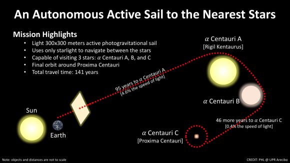
The projected path a lightsail mission to Alpha Centauri could take, which would allow it to detour to Proxima Centauri. Credit: PHL @ UPR Arecibo.

For the sake of their calculations, Heller and Hippke estimated that the craft would weigh less than 100 grams (3.5 ounces), and would be mounted on a sail measuring 100,000 m² (1,076,391 square foot) in surface area. Once these were complete, Hippke adapted them into a series of computer simulations. Based on their results, they proposed an entirely new mission concept that do away with the need for lasers entirely.

In essence, their revised concept called for an Autonomous Active Sail (AAS) craft that would provide for its own propulsion and stopping power. This craft would deploy its sail while in the Solar System and use the Sun’s solar wind to accelerate it to high speeds. Once it reached the Alpha Centauri System, it would redeploy its sail so that incoming radiation from Alpha Centauri A and B would have the effect of slowing it down.

An added bonus of this proposed maneuver is that the craft, once it had been decelerated to the point that it could effectively explore the Alpha Centauri system, could then use a gravity assist from these stars to reroute itself towards Proxima Centauri. Once there, it could conduct the first up-close exploration of Proxima b – the closest exoplanet to Earth – and determine what its atmospheric and surface conditions are like.

Since the existence of this planet was first announced by the European Southern Observatory back in August of 2016, there has been much speculation about whether or not it could be habitable. Having a mission that could examine it to check for the telltale markers – a viable atmosphere, a magnetosphere, and liquid water on the surface – would surely settle that debate.

As Heller explained in a press release from the Max Planck Institute, this concept presents quite a few advantages, but comes with its share of trade offs – not the least of which is the time it would take to get to Alpha Centauri. “Our new mission concept could yield a high scientific return, but only the grandchildren of our grandchildren would receive it,” he said. “Starshot, on the other hand, works on a timescale of decades and could be realized in one generation. So we might have identified a longterm, follow-up concept for Starshot.”

At present, Heller and Hippke are discussing their concept with Breakthrough Starshot to see if it would be viable. One individual who has looked over their work is Professor Avi Loeb, the Frank B. Baird Jr. Professor of Science at Harvard University, and the chairman of the Breakthrough Foundation’s Advisory Board. As he told Universe Today via email, the concept put forth by Heller and Hippke is worthy of consideration, but has its limitations:

“If it is possible to slow down a spacecraft by starlight (and gravitational assist), then it is also possible to launch it in the first place by the same forces… If so, why is the recently announced Breakthrough Starshot project using a laser and not Sunlight to propel our spacecraft? The answer is that our envisioned laser array can push the sail with an energy flux that is a million times larger than the local solar flux.

“In using starlight to reach relativistic speeds, one must use an extremely thin sail. In the new paper, Heller and Hippke consider the example of a milligram instead of a gram-scale sail. For a sail of area ten square meters (as envisioned in our Starshot concept study), the thickness of their sail must be only a few atoms. Such a surface is orders of magnitude thinner than the wavelength of light that it aims to reflect, and so its reflectivity would be low. It does not appear feasible to reduce the weight by so many orders of magnitude and yet maintain the rigidity and reflectivity of the sail material.

“The main constraint in defining the Starshot concept was to visit Alpha Centauri within our lifetime. Extending the travel time beyond the lifetime of a human, as advocated in this paper, would make it less appealing to the people involved. Also, one should keep in mind that the sail must be accompanied by electronics which will add significantly to its weight.”

In short, if time is not a factor, we can envision that our first attempts to reach another Solar System may indeed involve an AAS being propelled and slowed down by solar wind. But if we’re willing to wait centuries for such a mission to be completed, we might also consider sending rockets with conventional engines (possibly even crewed ones) to Alpha Centauri.

But if we are intent on getting there within our own lifetimes, then a laser-driven sail or something similar will have be the way to go. Humanity has spent over half a century exploring what’s in our own backyard, and some of us are impatient to see what’s next door!

Further Reading: Max Planck Institute, ArXiv

Superbowl Smackdown: Watch the Moon Occult Aldebaran on Sunday

Daytime Aldebaran
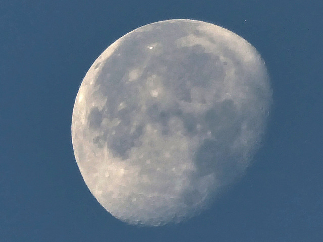
Can you see it? Dave Walker accidentally (!) caught Aldebaran near the daytime Moon on October 19th, 2016. Image credit and copyright: Dave Walker
Daytime Aldebaran
Can you see it? Dave Walker accidentally (!) caught Aldebaran near the daytime Moon on October 19th, 2016. Image credit and copyright: Dave Walker

Author’s note: This Superbowl Sunday event and 101 more like it are featured in our latest free e-book, 101 Astronomical Events for 2017, out now from Universe Today.

Sure, this Superbowl Sunday brings with it the promise of sacks, fumbles and tackles… but have you ever seen the Moon run down a star in the end zone? Just such an event, referred to as an occultation, happens this weekend for folks living around the Mediterranean and — just maybe for some sharp-eyed, telescope-owning observers based around the Caribbean region — this coming weekend.

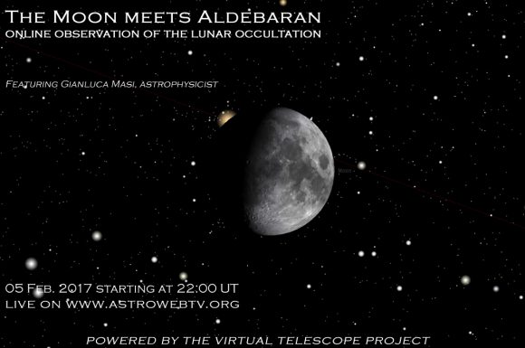
Update: be sure to watch this Sunday’s occultation of Aldebaran by the Moon courtesy of Gianluca Masi and the Virtual Telescope Project live starting at 22:00 UT/5:00 PM EST:

Live starting at 22:00 UT. Credit: The Virtual Telescope Project

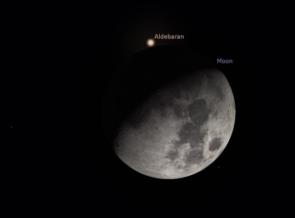
We’re talking about Sunday’s occultation of the bright star Aldebaran by the 64% illuminated waxing gibbous Moon. This is the 2nd occultation of Aldebaran by the Moon for 2017 and the 28th of the current ongoing cycle of 49 spanning from January 29th, 2015 to September 3rd, 2018. The Moon actually occults Aldebaran and Regulus once for every lunation in 2017. We won’t have another year featuring the occultations of two +1st magnitude stars (Spica and Antares) again until 2024.

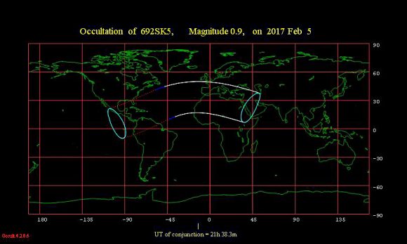
Occultation footprint
The footprint for the February 5th occultation of Aldebaran by the Moon. The broken lines show where the occultation occurs during daytime, and the solid lines denote where the occultation occurs under dark skies. Image credit: occult 4.2.

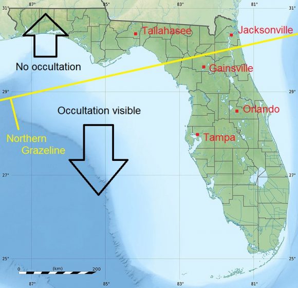
The event occurs under dark skies for observers based around the Mediterranean and under daytime afternoon skies for folks in central America, the Caribbean, northern South America and the Florida peninsula, including Astroguyz HQ based in Spring Hill, just north of the Tampa Bay area. We’ve managed to spy Aldebaran near the daytime Moon while the Sun was still above the horizon using binocs, and can attest that the +1st magnitude star is indeed visible, if you know exactly where to look for it.

Note that, like solar eclipses belonging to the same saros cycle, occultations of Aldebaran in the ongoing cycle drift north and westward from one to the next, to the tune of about 120 degrees longitude. Though most of North America sits this one out, we do get a front row seat for next lunation’s occultation of Aldebaran on the evening of March 4/5th. The next one is the best bright star occultation of Aldebaran by the Moon for North America in 2017. And be sure to check out the Moon this Sunday evening after the big game, and note Aldebaran hanging just off of its bright limb.

Moon motion
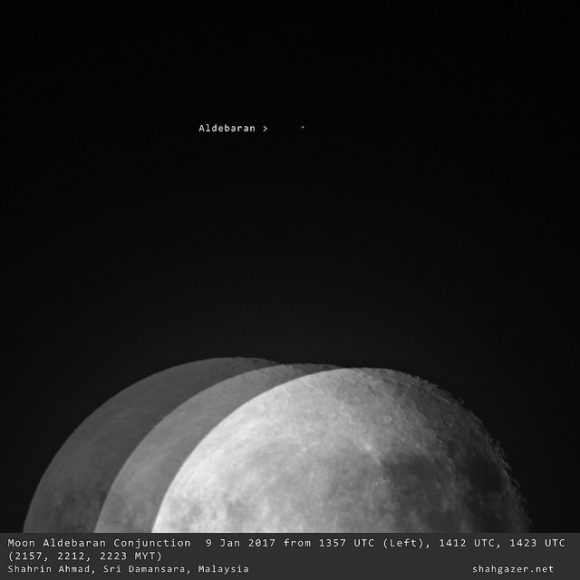
No, the wind is not shaking the ‘scope… Sharin Ahmad chronicled the motion of the Moon past Aldebaran from Kuala Lumpur, Malaysia last month. Image credit and copyright: Shahrin Ahmad (@shahgazer)

The ref will have a close call to make for this one. The northern grazeline in Florida might make this an especially interesting event to watch, though it’ll be challenge, as the occultation occurs in the afternoon under daylight skies. This crosses right along near the cities of Jacksonville and Gainsville. Clear, deep blue high contrast skies are key, and we’ll be watching from Astroguyz HQ north of Tampa Bay during this event.

The northern grazeline across the Florida peninsula for Sunday’s ‘big game’. Credit: Dave Dickinson.

Here are some key times from the occultation zone (noted in Universal Time):

Tampa, Florida

Ingress: 20:08 UT/Moon altitude: 23 degrees

Egress: 20:34 UT/Moon altitude: 29 degrees

Bogota, Columbia

Ingress: 19:34 UT/ Moon Altitude: 49 degrees

Egress: 20:29 UT/ Moon altitude: 31 degrees

The view from Jimena de la Frontera Spain just before the occultation. Credit: Stellarium.

Rome, Italy

Ingress: 20:21 UT/Moon altitude: 37 degrees

Egress: 23:12 UT/ Moon altitude: 28 degrees

Tel Aviv, Israel

Ingress: 22:39 UT/Moon altitude: 16 degrees

Egress: 23:29 UT/Moon altitude: 5 degrees

Casablanca, Morocco

Ingress: 21:49 UT/ Moon altitude: 61 degrees

Egress: 23:07 UT/ Moon altitude: 45 degrees

Note that this occultation spans five continents, a truly worldwide event. The International Occultation Timing Association (IOTA) maintains a page with an extensive list of times for cities worldwide. Note that when the Moon tackles Aldebaran, its also crossing the scrimmage line of the Hyades open cluster, so expect numerous occultations of fainter stars worldwide as well.

Aldebaran is the brightest star along the Moon’s path in our current epoch, along with runner-ups Spica, Regulus and Antares. Though Aldebaran is 1.5 times the mass of our Sun, it’s also 65 light years away, and only appears 20 milliarcseconds (mas) in size, about the equivalent of a 40 meter diameter crater from the distance of the Moon. Still, you might just notice a brief pause as Aldebaran fades then winks out on the dark limb of the Moon, a tiny hitch betraying its diminutive angular size.

And the clockwork gears of that biggest game of all, the Universe, grind on. Don’t miss this first big ticket astronomical event for February 2017, coming to a sky above you. Next up, we’ll watching out for another bright star occultation, two eclipses, and the close passage of a comet near the Earth.

Stay tuned!

Get Away From It All with these Amazing DTM Views of Mars

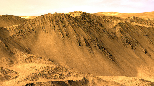
The rim of Tooting Crater on Mars, rendered from HiRISE data using Autodesk Maya and Adobe Photoshop. Credit: NASA/JPL/University of Arizona/USGS/image editing by Kevin Gill.

By day, Kevin Gill is a software engineer at the Jet Propulsion Laboratory. But on nights and weekends he takes data from spacecraft and turns them into scenes that can transport you directly to the surface of Mars.

Gill is one of many so-called “amateur” image editing enthusiasts that take real, high-resolution data from spacecraft and create views that can make you feel like you are standing on the surface of Mars, or out flying around the Solar System.

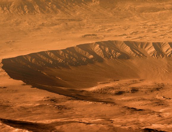
Gasa Crater on Mars. Rendered using Autodesk Maya and Adobe Photoshop. HiRISE data processed using HiView and gdal. Credit: NASA/JPL/University of Arizona/USGS/image editing by Kevin Gill.

Some of the best data around for these purposes come from the HiRISE camera on board the Mars Reconnaissance Orbiter. Data known as Digital Terrain Model (DTM) files, the HiRISE DTMs are made from two or more images of the same area of a region on Mars, taken from different angles. This data isn’t just for making stunning images or amazing movies. For scientists, DTMs are very powerful research tools, used to take measurements such a elevation information and model geological processes.

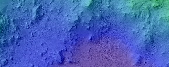
So, just how do you go from this DTM image from HiRISE:

DTM image of the Central Peak of Elorza Crater on Mars. Credit: NASA/JPL/University of Arizona/USGS

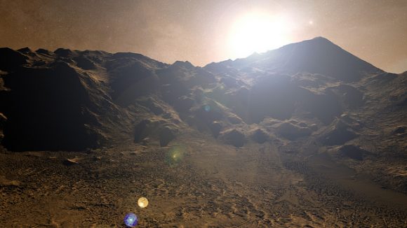
To this amazing image?

Martian sunrise over the Central Peak of Elorza Crater. Rendered using Autodesk Maya and Adobe Photoshop. HiRISE data processed using HiView and gdal. Credit: NASA/JPL/University of Arizona/USGS/image editing by Kevin Gill

I’m going to let Kevin explain it:

To prep the data, I use Photoshop (to convert the JP2 file to a TIFF), and then standard GIS tools like gdal (Geospatial Data Abstraction Library) to create textures for 3D modeling. Using Autodesk Maya, I input those into a material as a color texture (orthoimagery) or displacement map (the DTM data).

I connect that material to a NURBS plane (sort of like a polygon mesh) that is scaled similarly to the physical properties of the data. I set up a camera at a nice angle (it takes a number of low-resolution test renders to get an angle I like) and let it render.

Then I just pull that render into Photoshop where I have a series of monochromatic color tints which gives the image it’s Martian feel. For the sky, I use either a sky from a MSL MastCam image or one that I took outside with my cell phone. If I’m using a sky I took with my cell phone, I’ll adjust the colors to make it look more like it would on Mars. If the colors in the image are still boring at this point, I may run a HDR adjustment on it in Photoshop.

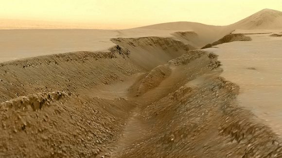
Fissure in the Cerberus region. This false color view of a volcanic fissure in the Cerberus region of Mars was created using a digital terrain model (DTM) from the High Resolution Imaging Science Experiment (HiRISE) camera aboard NASA’s Mars Reconnaissance Orbiter. The horizon was taken from Curiosity Mastcam imagery. Credit: NASA/JPL-Caltech/University of Arizona/ image editing by Kevin Gill.

What all this means is that you can create all these amazing view, plus incredible flyover videos, like this one Kevin put together of Endeavour Crater:

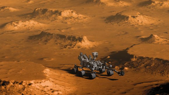
Or you can have some fun and visualize where the Curiosity rover is sitting:

Doin’ Science with Curiosity. Created using HiRIST DTM and Ortho data and NASA model of Curiosity. Rendered using Autodesk Maya and Adobe Photoshop. Curiosity Model: Brian Kumanchik, NASA/JPL-Caltech. Image editing by Kevin Gill.

We’ve written about this type of image editing previously, with the work of the people at UnmannedSpaceflight.com and others. Of course, the image editing software keeps improving, along with all the techniques.

Kevin also wanted to point out the work of other image editing enthusiast, Sean Doran.

“Sean’s work is resulting in views similar to mine,” Kevin said via email. “I know he’s using a process very different from mine, but we are thinking along the same lines in what we want out of the end product. His are quite impressive.”

For example, here is a flyover video of the Opportunity rover sitting along the rim of Endeavour Crater:

You can see more of Sean’s work on his Flickr page

And you can see all of Kevin’s Mars DTM images at his Flick page here. Kevin also recently wrote up a great explanation of his image editing for The Planetary Society, which you can read here.

Thanks to Kevin Gill for sharing his images and expertise!

Preleminary Results In NASA Twins Study Released

NASA's astronauts twins, Scott Kelly (l) and Mark Kelly (r). Image: NASA
NASA's astronaut twins, Scott Kelly (l) and Mark Kelly (r). Image: NASA

In 1996, something remarkable happened at NASA. Twin brothers Mark and Scott Kelly were accepted into NASA; Mark as a shuttle pilot, and Scott into technical operations on the ground, at least initially. Eventually, both brothers became astronauts. They are the only siblings to have both been in space.

Whether it was intentional or not, having twin brothers gave NASA an important opportunity. They could use one twin as a control group, and send the other on a prolonged mission into space. That allowed NASA to carry out important research on the effects of space travel on the human body.

In March 2016, Scott Kelly returned from a year long (340 days) mission aboard the International Space Station, while his brother Mark stayed on Earth. Genetic samples were taken from each brother before and after Scott’s time aboard the ISS. Now, NASA has released the preliminary results of this unprecedented opportunity.

Expedition 46 Commander Scott Kelly of NASA is seen after returning to Ellington Field, Thursday, March 3, 2016 in Houston, Texas after his return to Earth the previous day. Kelly and Flight Engineers Mikhail Kornienko and Sergey Volkov of Roscosmos landed in their Soyuz TMA-18M capsule in Kazakhstan on March 1 (Eastern time).

NASA’s Human Research Program did the study, and the results were released at their Investigator’s Workshop on the week of January 23rd. The theme of that workshop was A New Dawn: Enabling Human Space Exploration. Though the studies are on-going, these initial results are interesting.

Omics

Mike Snyder, who is the Integrated Omics investigator, reported his findings. He found an altered level of lipids in Scott, the flight twin, which indicates inflammation. He also found increased 3-indolepropionic (IPA) in Mark, the ground twin. IPA is a potential brain antioxidant therapeutic, and also helps maintain normal insulin levels, to stabilize blood sugar after meals.

Telomeres and Telomerase

Telomeres and Telomerase are part of the chromosomal system in the human body. Susan Bailey reported that for Scott, the flight twin, the length of his white blood cell’s telomeres increased while in space. Typically, they decrease as a person ages. Once on Earth, they began to shorten again.

Telomerase, an enzyme that repairs telomeres, increased in both brothers in November, which could be related to a stressful family event at that time.

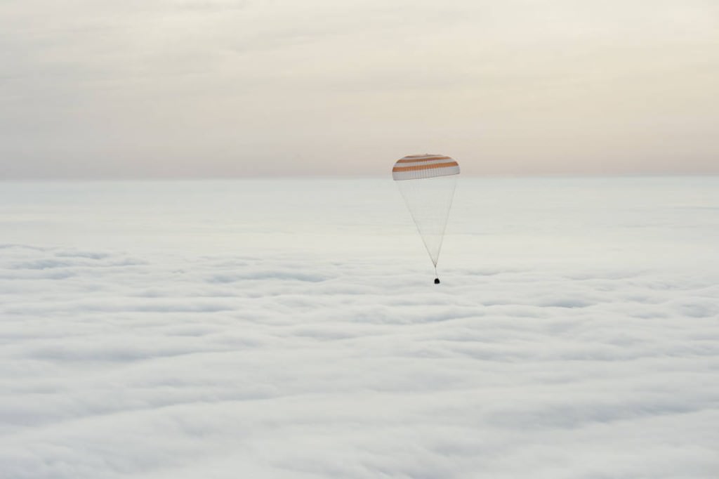
The Soyuz TMA-18M spacecraft is seen as it lands with Expedition 46 Commander Scott Kelly of NASA and Russian cosmonauts Mikhail Kornienko and Sergey Volkov in Kazakhstan on Wednesday, March 2, 2016. Photo Credit: (NASA/Bill Ingalls)

Cognitive Performance in Spaceflight

Mathias Basner is studying Cognitive Performance in Spaceflight, especially the difference in cognition between a 12-month mission and a six-month mission. Though he found a slight decrease in speed and accuracy after the mission, he found no real difference in cognition between 6 month and 12 month missions.

Biochemistry

Scott Smith’s investigation into biochemistry showed a decrease in bone density during the second half of Scott’s mission. Scott also had increased levels of a biochemical marker for inflammation once he returned to Earth.

Microbiome in the Gastro-Intestinal Tract

Fred Turek reported preliminary results of his investigation into the bacteria in the GI (microbiome) tract that help digestion. There were many differences in the twins’ biomes, but that was expected because of their different diets and environments. There were interesting differences in Scott’s biome between his time in space and his time on the ground. The ratio between two dominant bacterial groups shifted during his flight time compared to his ground time.

Immunome Studies

Emmanuel Mignot investigated changes in the bodies of both twins before and after a flu vaccine was given. Both twins showed increased levels of T-cell receptors after the vaccine, which was the expected immune response.

Genome Sequencing

Chris Mason is performing Genome Sequencing on the DNA and RNA contained within the twins’ white blood cells with his investigation. RNA sequencing showed that over 200,000 RNA molecules were expressed differently between the twins. Mason will look closer to see if a “space gene” could have been activated while Scott was in space.

Epigenomics

Andy Feinberg studies how the environment regulates our gene expression, which is known as epigenomics. Scott’s white blood cell DNA showed decreased levels of chemical modification while in flight, and a return to normal once back on Earth. The same level in Mark (the ground twin) increased midway through the study, but then returned to normal. There was variability between the twins, called epigenetic noise. This noise was higher in Scott during his spaceflight, and returned to baseline levels once back on Earth. This could indicate that some genes are more sensitive to the changing environment of spaceflight than others.

There’s a lot more research required to truly understand these results. Once they’re looked at in coordination with other physiological, psychological, and technological investigations, the picture will become clearer. Later in 2017, there will be a joint publication of further results, as well as individual research papers.

NASA’s goal is to make space travel safer for astronauts, and to make missions more effective and efficient. With all the talk of missions to Mars in the next decade, these results are arriving at the perfect time.

What is the Weather like on Mars?

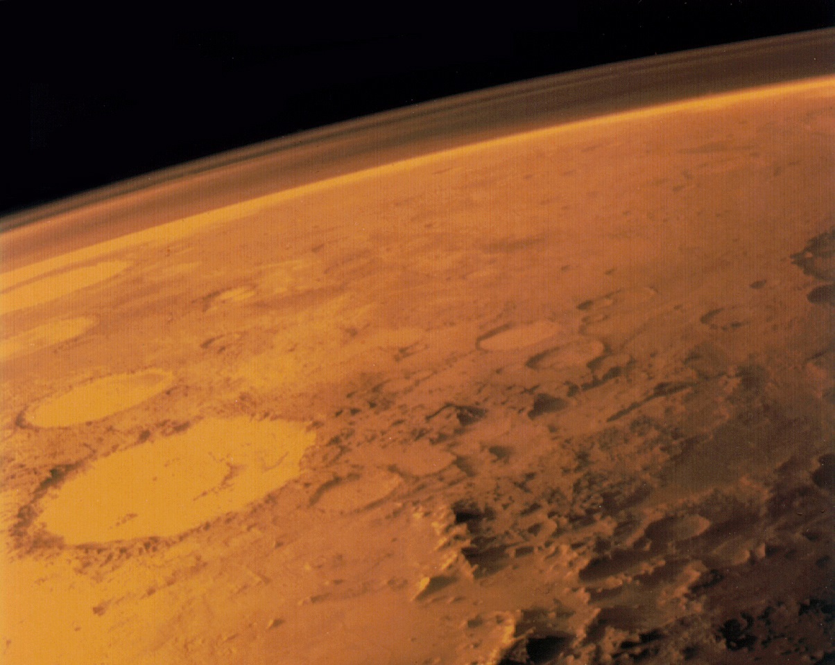
Image taken by the Viking 1 orbiter in June 1976, showing Mars thin atmosphere and dusty, red surface. Credits: NASA/Viking 1

Welcome back to our planetary weather series! Today, we take a look at Earth’s neighbor and possible “backup location” for humanity someday – Mars!

Mars is often referred to as “Earth’s Twin”, due to the similarities it has with our planet. They are both terrestrial planets, both have polar ice caps, and (at one time) both had viable atmospheres and liquid water on their surfaces. But beyond that, the two are quite different. And when it comes to their atmospheres and climates, Mars stands apart from Earth in some rather profound ways.

For instance, when it comes to the weather on Mars, the forecast is usually quite dramatic. Not only does Martian weather vary from day to day, it sometimes varies from hour to hour. That seems a bit unusual for a planet that has an atmosphere that is only 1% as dense as the Earth’s. And yet, Mars manages to really up the ante when it comes to extreme weather and meteorological phenomena.

Mars’ Atmosphere:

Mars has a very thin atmosphere which is composed of 96% carbon dioxide, 1.93% argon and 1.89% nitrogen, along with traces of oxygen and water. The atmosphere is quite dusty, containing particulates that measure 1.5 micrometers in diameter, which is what gives the Martian sky its tawny color when seen from the surface. Mars’ atmospheric pressure ranges from 0.4 to 0.87 kPa, which is the equivalent of about 1% of Earth’s at sea level.

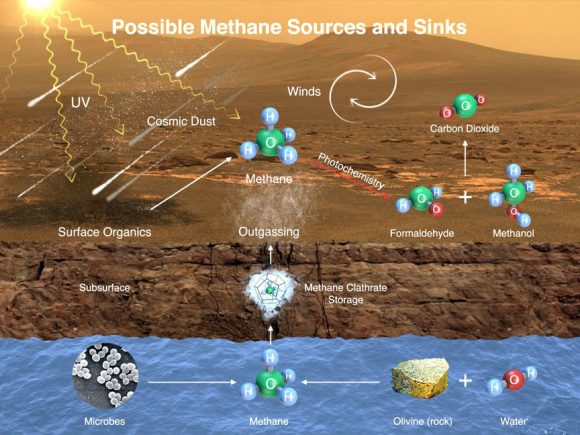
This image illustrates possible ways methane might get into Mars’ atmosphere and also be removed from it. Credit: NASA/JPL-Caltech/SAM-GSFC/Univ. of Michigan

Because of this thin atmosphere, and its greater distance from the Sun, the surface temperature of Mars is much colder than what we experience here on Earth. The planet’s average temperature is -63 °C (-82 °F), with a low of -143 °C (-226 °F) during the winter at the poles, and a high of 35 °C (95 °F) during summer and midday at the equator.

Due to the extreme lows in temperature at the poles, 25-30% of the carbon dioxide in the atmosphere freezes and becomes dry ice that is deposited on the surface. While the polar ice caps are predominantly water, the Martian North Pole has a layer of dry ice measuring one meter thick in winter, while the South Pole is covered by a permanent layer that is eight meters deep.

Trace amounts of methane and ammonia have also been detected in the Martian atmosphere. In the case of the former, it has an estimated concentration of about 30 parts per billion (ppb), though the Curiosity rover detected a “tenfold spike” on December 16th, 2014. This detection was likely localized, and the source remains a mystery. Similarly, the source of ammonia is unclear, though volcanic activity has been suggested as a possibility.

Meteorological Phenomena:

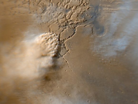
Mars is also famous for its intense dust storms, which can range from small tornadoes to planet-wide phenomena. Instances of the latter coincide with dust being blown into the atmosphere, causing it to be heated up from the Sun. The warmer dust-filled air rises and the winds get stronger, creating storms that can measure up to thousands of kilometers in width and last for months at a time. When they get this large, they can actually block most of the surface from view.

Image capturing an active dust storm on Mars. Image credits: NASA/JPL-Caltech/MSSS

Due to its thin atmosphere, low temperatures and lack of a magnetosphere, liquid precipitation (i.e. rain) does not take place on Mars. Basically, solar radiation would cause any liquid water in the atmosphere to disassociate into hydrogen and oxygen. And because of the cold and thin atmosphere, there is simply not enough liquid water on the surface to maintain a water cycle.

Occasionally, however, thin clouds do form in the atmosphere and precipitation falls in the form of snow. This consists primarily of carbon dioxide snow, which has been observed in the polar regions. However, small traces of frozen clouds carrying water have also been observed in Mars’ upper atmosphere in the past, producing snow that is restricted to high altitudes.

One such instance was observed on September 29th, 2008, when the Phoenix lander took pictures of snow falling from clouds that were 4 km (2.5 mi) above its landing site near the Heimdal Crater. However, data collected from the lander indicated that the precipitation vaporized before it could reach the ground.

Aurorae on Mars:

Auroras have also been detected on Mars, which are also the result of interaction between magnetic fields and solar radiation. While Mars has little magnetosphere to speak of, scientists determined that aurorae observed in the past corresponded to an area where the strongest magnetic field is localized on the planet. This was concluded by analyzing a map of crustal magnetic anomalies compiled with data from Mars Global Surveyor.

Mars has magnetized rocks in its crust that create localized, patchy magnetic fields (left). In the illustration at right, we see how those fields extend into space above the rocks. At their tops, auroras can form. Credit: NASA

A notable example is the one that took place on August 14th, 2004, and which was spotted by the SPICAM instrument aboard the Mars Express. This aurora was located in the skies above Terra Cimmeria – at geographic coordinates 177° East, 52° South – and was estimated to be quite sizable, measuring 30 km across and 8 km high (18.5 miles across and 5 miles high).

More recently, an aurora was observed on Mars by the MAVEN mission, which captured images of the event on March 17th, 2015, just a day after an aurora was observed here on Earth. Nicknamed Mars’ “Christmas lights”, they were observed across the planet’s mid-northern latitudes and (owing to the lack of oxygen and nitrogen in Mars’ atmosphere) were likely a faint glow compared to Earth’s more vibrant display.

To date, Mars’ atmosphere, climate and weather patterns have been studied by dozens of orbiters, landers, and rovers, consisting of missions by NASA, Roscomos, as well as the European Space Agency and Indian federal space program. These include the Mariner 4 probe, which conducted the first flyby of Mars – a two-day operation that took place between July 14th and 15th, 1965.

The crude data it obtained was expanded on by the later later Mariner 6 and 7 missions (which conducted flybys in 1969). This was followed by the Viking 1 and 2 missions, which reached Mars in 1976 and became the first spacecraft to land on the planet and send back images of the surfaces.

Since the turn of the century, six orbiters have been placed in orbit around Mars to gather information on its atmosphere – 2001 Mars Odyssey, Mars Express, Mars Reconnaissance Orbiter, MAVEN, Mars Orbiter Mission and ExoMars Trace Gas Orbiter. These have been complimented by rover and lander missions like Pheonix, Spirit and Opportunity, and Curiosity.

In the future, several additional missions are scheduled to reach the Red Planet, which are expected to teach us even more about its atmosphere, climate and weather patterns. What we find will reveal much about the planet’s deep past, its present condition, and perhaps even help us to build a future there.

We have written many interesting articles about Martian weather here at Universe Today. Here’s Mars Compared to Earth, It Only Happens on Mars: Carbon Dioxide Snow is Falling on the Red Planet, Snow is Falling from Martian Clouds, Surprise! Mars has Auroras Too! and NASA’s MAVEN Orbiter Discovers Solar Wind Stripped Away Mars Atmosphere Causing Radical Transformation.

For more information, check out this NASA article about how space weather affects Mars.

Finally, if you’d like to learn more about Mars in general, we have done several podcast episodes about the Red Planet at Astronomy Cast. Episode 52: Mars, and Episode 91: The Search for Water on Mars.

Sources:

Outstanding Opportunity Rover Making ‘Amazing New Discoveries’ 13 Years After Mars Touchdown – Scientist Tells UT

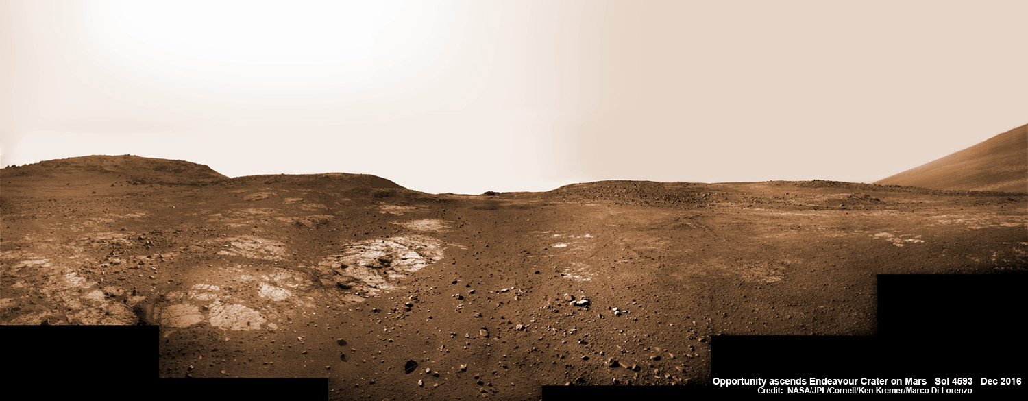
13 Years on Mars! On Christmas Day 2016, NASA’s Opportunity rover scans around vast Endeavour crater as she ascends steep rocky slopes on the way to reach a water carved gully along the eroded craters western rim. This navcam camera photo mosaic was assembled from raw images taken on Sol 4593 (25 Dec. 2016) and colorized. Credit: NASA/JPL/Cornell/Ken Kremer/kenkremer.com/Marco Di Lorenzo
13 Years on Mars!
On Christmas Day 2016, NASA’s Opportunity rover scans around vast Endeavour crater as she ascends steep rocky slopes on the way to reach a water carved gully along the eroded craters western rim. This navcam camera photo mosaic was assembled from raw images taken on Sol 4593 (25 Dec. 2016) and colorized. Credit: NASA/JPL/Cornell/Ken Kremer/kenkremer.com/Marco Di Lorenzo

NASA’s truly outstanding Opportunity rover continues “making new discoveries about ancient Mars” as she commemorates 13 Years since bouncing to a touchdown on Mars, in a feat that is “truly amazing” – the deputy chief scientist Ray Arvidson told Universe Today exclusively.

Resilient Opportunity celebrated her 13th birthday on Sol 4623 on January 24, 2017 PST while driving south along the eroded rim of humongous Endeavour crater – and having netted an unfathomable record for longevity and ground breaking scientific discoveries about the watery environment of the ancient Red Planet.

“Reaching the 13th year anniversary with a functioning rover making new discoveries about ancient Mars on a continuing basis is truly amazing,” Ray Arvidson, Opportunity Deputy Principal Investigator of Washington University in St. Louis, told Universe Today.

Put another way Opportunity is 13 YEARS into her 3 MONTH mission! And still going strong!

During the past year the world famous rover discovered “more extensive aqueous alteration within fractures and more mild alteration within the bedrock outcrops” at Endeavour crater, Arvidson elaborated.

And now she is headed to her next target – an ancient water carved gully!

The gully is situated about 0. 6 mile (1.6 km) south of the robots current location.

But to get there she first has to heroically ascend steep rocky slopes inclined over 20 degrees along the eroded craters western rim – and it’s no easy task! Slipping and sliding along the way and all alone on difficult alien terrain.

Furthermore she is 51 times beyond her “warrantied” life expectancy of merely 90 Sols promised at the time of landing so long ago – roving the surface of the 4th rock from the Sun during her latest extended mission; EM #10.

How was this incredible accomplishment achieved?

“Simply a well-made and thoroughly tested American vehicle,” Arvidson responded.

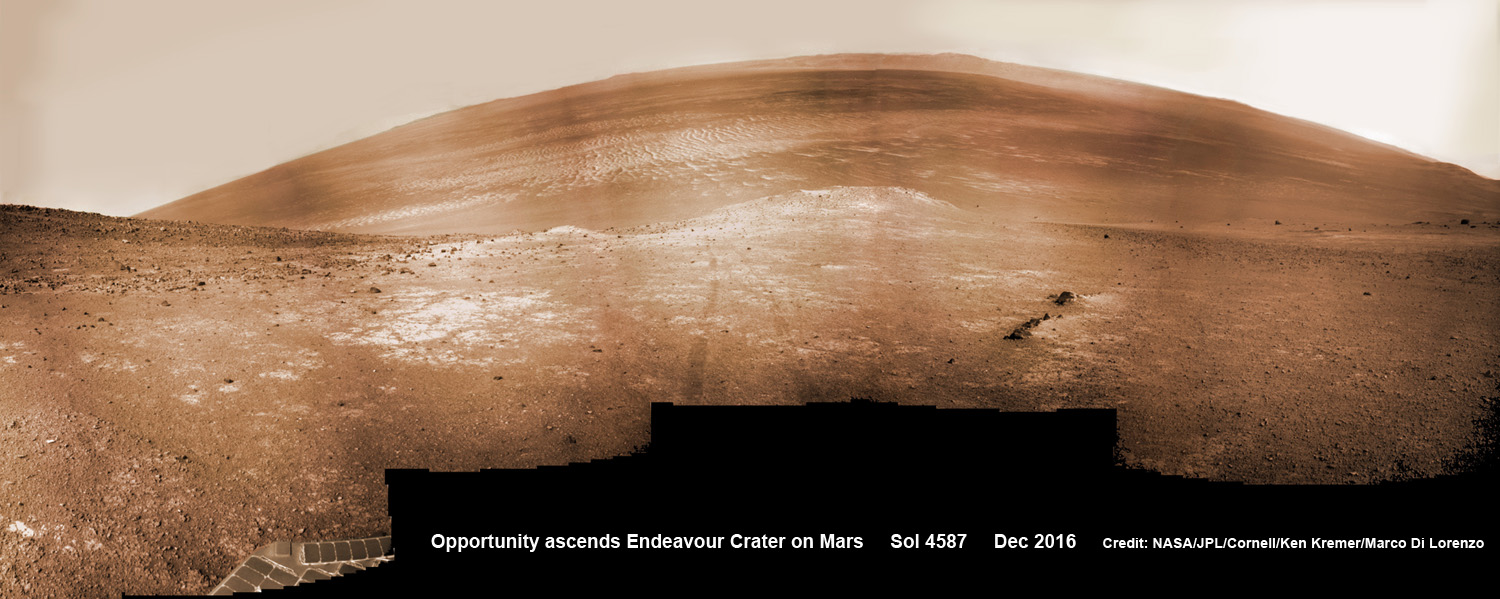
NASA’s Opportunity rover scans around and across to vast Endeavour crater on Dec. 19, 2016, as she climbs steep slopes on the way to reach a water carved gully along the eroded craters western rim. Note rover wheel tracks at center. This navcam camera photo mosaic was assembled from raw images taken on Sol 4587 (19 Dec. 2016) and colorized. Credit: NASA/JPL/Cornell/Ken Kremer/kenkremer.com/Marco Di Lorenzo

The six wheeled rover landed on Mars on January 24, 2004 PST on the alien Martian plains at Meridiani Planum -as the second half of a stupendous sister act.

Her twin sister Spirit, had successfully touched down 3 weeks earlier on January 3, 2004 inside 100-mile-wide Gusev crater and survived more than six years.

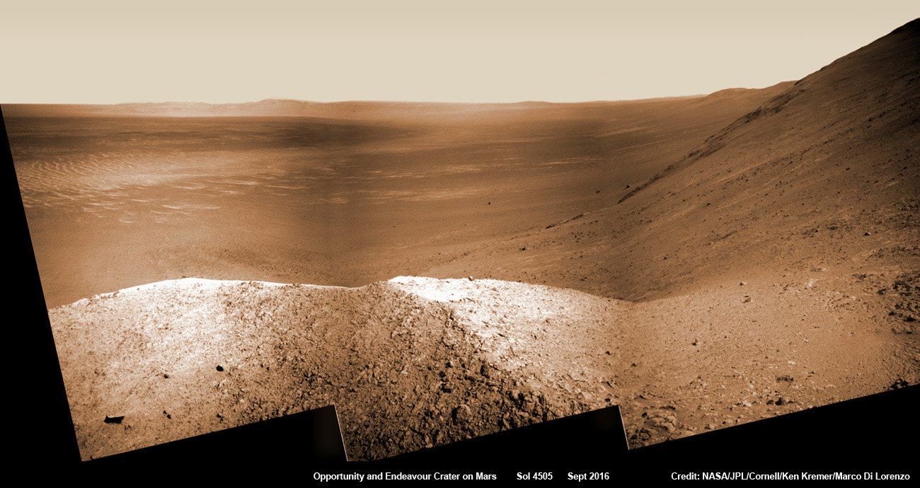
NASA’s Opportunity explores Spirit Mound after descending down Marathon Valley and looks out across the floor of vast Endeavour crater. This navcam camera photo mosaic was assembled from raw images taken on Sol 4505 (25 Sept 2016) and colorized. Credit: NASA/JPL/Cornell/ Ken Kremer/kenkremer.com/Marco Di Lorenzo

Opportunity concluded 2016 and starts 2017 marching relentlessly towards an ancient water carved gully along the eroded rim of vast Endeavour crater – the next science target on her heroic journey traversing across never before seen Red Planet terrains.

Huge Endeavour crater spans some 22 kilometers (14 miles) in diameter.

Throughout 2016 Opportunity was investigating the ancient, weathered slopes around the Marathon Valley location in Endeavour crater. The area became a top priority science destination after the slopes were found to hold a motherlode of ‘smectite’ clay minerals based on data from the CRISM spectrometer circling overhead aboard a NASA Mars orbiter.

The smectites were discovered via extensive, specially targeted Mars orbital measurements gathered by the CRISM (Compact Reconnaissance Imaging Spectrometer for Mars) spectrometer on NASA’s Mars Reconnaissance Orbiter (MRO) – accomplished earlier at the direction of Arvidson.

Opportunity was descending down Marathon Valley the past year to investigate the clay minerals formed in water. They are key to helping determine the habitability of the Red Planet when it was warmer and wetter billions of years ago.

What did Opportunity accomplish scientifically at Marathon Valley during 2016?

“Key here is the more extensive aqueous alteration within fractures and more mild alteration within the bedrock outcrops,” Arvidson explained to me.

“Fractures have red pebbles enhanced in Al and Si (likely by leaching out more soluble elements), hematite, and in the case of our scuffed fracture, enhanced sulfate content with likely Mg sulfates and other phases. Also the bedrock is enriched in Mg and S relative to other Shoemaker rocks and these rocks are the smectite carrier as observed from CRISM ATO data.”

Marathon Valley measures about 300 yards or meters long. It cuts downhill through the west rim of Endeavour crater from west to east – the same direction in which Opportunity drove downhill from a mountain summit area atop the crater rim.

Opportunity has been exploring Endeavour since arriving at the humongous crater in 2011. Endeavour crater was formed when it was carved out of the Red Planet by a huge meteor impact billions of years ago.

“Endeavour crater dates from the earliest Martian geologic history, a time when water was abundant and erosion was relatively rapid and somewhat Earth-like,” explains Larry Crumpler, a science team member from the New Mexico Museum of Natural History & Science.

Opportunity has been climbing up very steep and challenging slopes to reach the top of the crater rim. Then she will drive south to Cape Byron and the gully system.

“We have had some mobility issues climbing steep, rocky slopes. Lots of slipping and skidding, but evaluating the performance of the rover on steep, rocky and soil-covered slopes was one of the approved extended mission objectives,” Arvidson explained.

“We are heading out of Cape Tribulation, driving uphill to the southwest to reach the Meridiani plains and then to drive to the western side of Cape Byron to the head of a gully system.”

What’s ahead for 2017? What’s the importance of exploring the gully?

“Finish up work on Cape Tribulation, traverse to the head of the gully system and head downhill into one or more of the gullies to characterize the morphology and search for evidence of deposits,” Arvidson elaborated.

“Hopefully test among dry mass movements, debris flow, and fluvial processes for gully formation. The importance is that this will be the first time we will acquire ground truth on a gully system that just might be formed by fluvial processes. Will search for cross bedding, gravel beds, fining or coarsening upward sequences, etc., to test among hypotheses.”

How long will it take to reach the gully?

“Months to the gully,” replied Arvidson. After arriving at the top of the crater rim, the rover will actually drive part of the way on the Martian plains again during the southward trek to the gully.

“And we will be driving on the plains to drive relatively long distances with an intent of getting to the gully well before the winter season.”

As of today, Jan 31, 2017, long lived Opportunity has survived 4630 Sols (or Martian days) roving the harsh environment of the Red Planet.

Opportunity has taken over 216,700 images and traversed over 27.26 miles (43.87 kilometers) – more than a marathon.

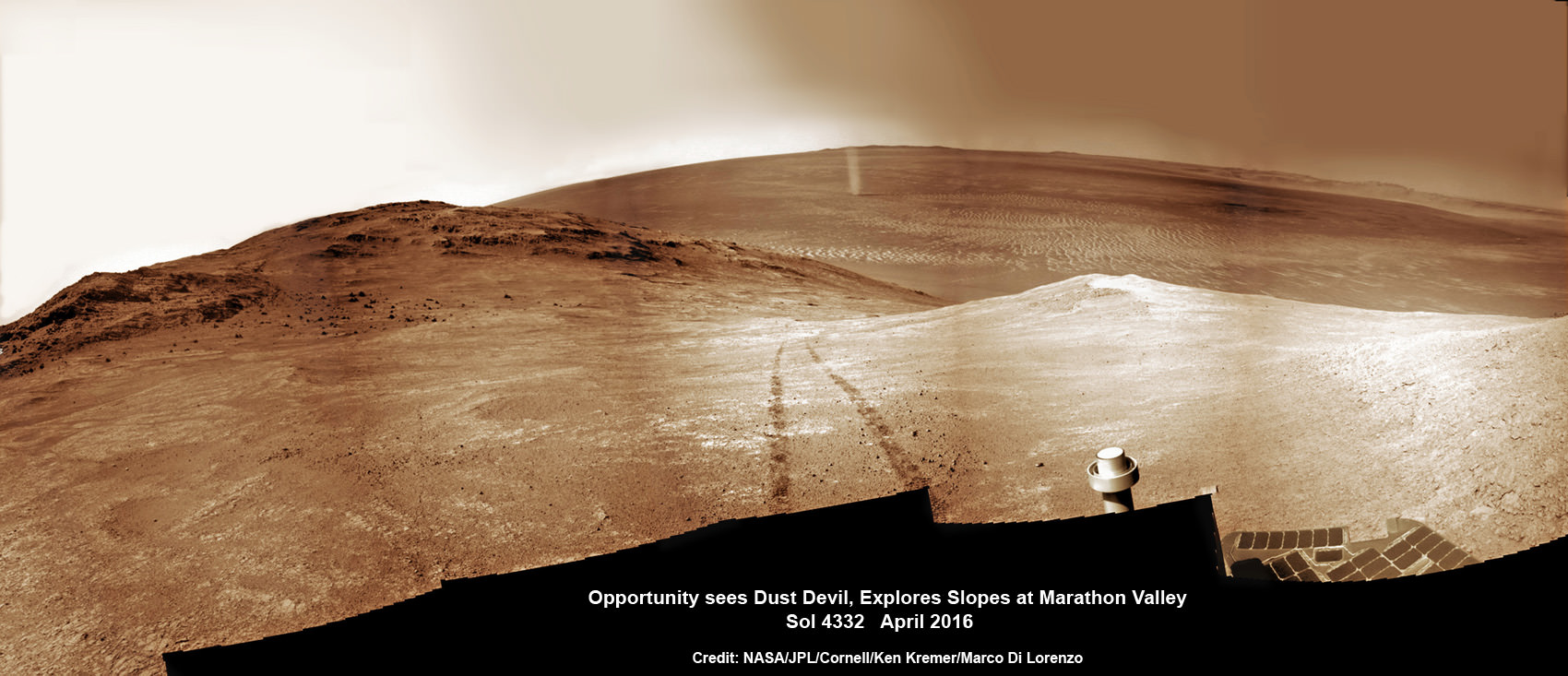
NASA’s Opportunity rover discovers a beautiful Martian dust devil moving across the floor of Endeavour crater as wheel tracks show robots path today exploring the steepest ever slopes of the 13 year long mission, in search of water altered minerals at Knudsen Ridge inside Marathon Valley on 1 April 2016. This navcam camera photo mosaic was assembled from raw images taken on Sol 4332 (1 April 2016) and colorized. Credit: NASA/JPL/Cornell/ Ken Kremer/kenkremer.com/Marco Di Lorenzo

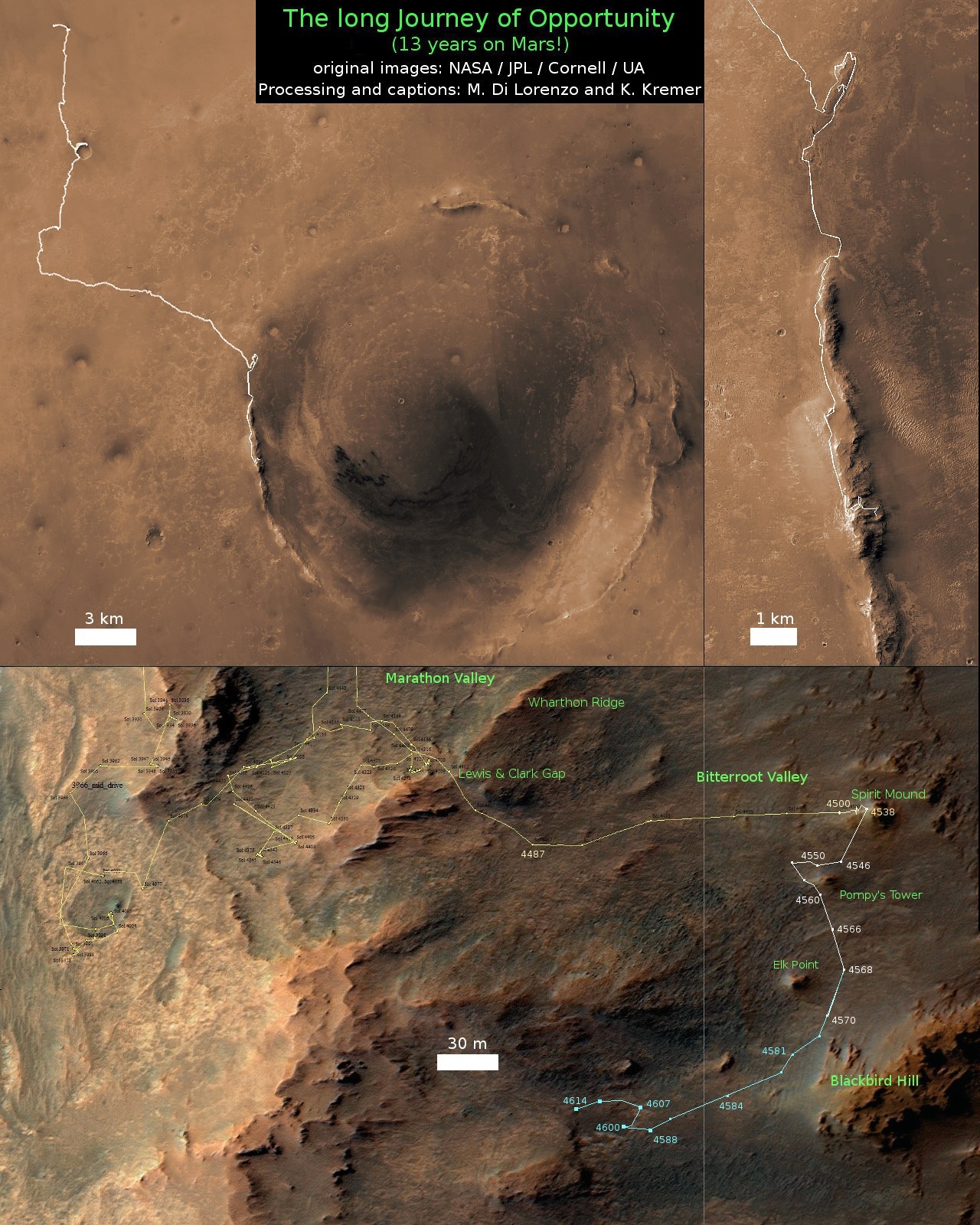
See our updated route map below. It shows the context of the rovers over 13 year long traverse spanning more than the 26 mile distance of a Marathon runners race.

The rover surpassed the 27 mile mark milestone on November 6, 2016 (Sol 4546).

The power output from solar array energy production is currently 416 watt-hours, before heading into another southern hemisphere Martian winter in 2017. It will count as Opportunities 8th winter on Mars.

Meanwhile Opportunity’s younger sister rover Curiosity traverses and drills into the lower sedimentary layers at the base of Mount Sharp.

Stay tuned here for Ken’s continuing Earth and planetary science and human spaceflight news.

Ken Kremer

13 Year Traverse Map for NASA’s Opportunity rover from 2004 to 2017. This map shows the entire 43 kilometer (27 mi) path the rover has driven on the Red Planet during more than 13 years and more than a marathon runners distance for over 4614 Sols, or Martian days, since landing inside Eagle Crater on Jan 24, 2004 – to current location at the western rim of Endeavour Crater. After descending down Marathon Valley and after studying Spirit Mound, the rover is now ascending back uphill on the way to a Martian water carved gully. Rover surpassed Marathon distance on Sol 3968 after reaching 11th Martian anniversary on Sol 3911. Opportunity discovered clay minerals at Esperance – indicative of a habitable zone – and searched for more at Marathon Valley. Credit: NASA/JPL/Cornell/ASU/Marco Di Lorenzo/Ken Kremer/kenkremer.com

What is a Butte?

Image of the Mittens and Merrick Butte, in Monument Valley, Arizona. Credit: Wikipedia Commons/Wolfgang Staudt

During the 16h century, Spanish explorers ventured north from Mexico looking for gold and the legendary “Seven cities of Cibola”. What they found instead were some of the most amazing natural formations in the world, which are today known as “buttes”. To the local Hopi, Navajo, and other indigenous nations, these features – which resemble tall, isolated plateaus – have been regarded as sacred sites since time immemorial.

By the beginning of the 19th century, the term “butte” entered common parlance and quickly became adopted by the geological community. And while their existence was something of a mystery for thousands of years, spawning mythological connections and folk tales, improvements in the fields of Earth sciences and geology have led scientists to understand what these features are and how they are formed.

Definition:

By definition, a Butte is a conspicuous isolated hill with steep, often vertical sides and a small, relatively flat top. The word “butte” comes from a French word meaning “small hill”. They are not to be confused with Mesas or Plateaus, which are typically differentiated based on the fact that their top surfaces are larger than their vertical faces, while a butte is taller than it is wide. However, definitions of the surface areas of mesas and buttes vary.

The Courthouse Butte, located near the town of Sedona, Arizona. Credit: Wikipedia Commons

One source states that a mesa has a surface area of less than 10 square kilometers, while a butte has a surface area less than 1,000 square meters. Another source states that the surface area of a mesa is larger than 2.59 square kilometers. However, all sides are in agreement that is the difference between their vertical and horizontal measurements that are key.

Formation:

Both buttes and mesas are formed by the same geological process, which involves the physical weathering of rock formations. Essentially, this involves the surface material of a hill or mountain (the cap rock) resists wind and water erosion, but the underlying materials do not. Over time, the underlying material is stripping away, leaving an isolated, standing feature with a flat top.

The top layer of a butte is a hardened layer of rock that is resistant to erosion. This top layer, called the cap rock, is usually composed of sedimentary rock, but sometimes is the remains of cooled and hardened lava that had spread out across the landscape in repeated flows from fissures or cracks in the ground.

Beneath this flat, protective cap of rock, horizontal layers of softer sedimentary rock are found. To varying degrees, these layers are not as resistant to wind and water erosion. As a result, when the softer rock is stripped away, a standing, isolated rock is left behind. Typically, buttes are found in arid and semiarid regions.

Merrick’s Butte, in Monument Valley, Utah. Credit: Wikipedia Commons/Ernst Brötz

Because water evaporates quickly in these normally dry environments, plants and other ground cover are scarce. Left exposed to the action of running water, the bare sides of the softer rock layers of buttes are eroded away over time. The base of these landforms is often gently sloped, contrasting with the almost-vertical sides leading down from the top. Rock material that has been eroded from the sides is carried downward, forming this sloping base.

Notable Buttes:

Because of their isolated and imposing nature, many buttes have become geographical land markers and major tourist destinations. They also figured prominently in the spiritual beliefs and creation myths of the indigenous peoples across North America. Buttes can be found all over North America, though they are most commonly found in the arid regions of the American Southwest.

For example, there is the Courthouse Butte, a prominent feature located just north of the Village of Oak Creek, and south of the town of Sedona in Yavapai County. Then there’s the Elephant Butte, which is located in the Elephant Butte Lake State Park in Sierra Country, New Mexico,. This geographical feature is so-named because of the combination of a vertical side and a sloping side, which resemble the shape of an elephant.

Bear Butte in South Dakota also has a long history of being a geological and cultural significant feature. Long before the arrival of European settlers, Bear Butte featured prominently in the religious and mythological traditions of the Lakota, Sioux and Cheyenne nations. To the Lakota and Sioux, the feature was known as “Matho Paha” (literally, Bear Mountain), while the Cheyenne referred to it as Nahkohe-vose (“bear hill”).

Bear Butte (aka. Bear Mountain or Bear Hill),, located in South Dakota. Credit: Jerrye & Roy Klotz, MD.

According to Cheyenne mythology, it was here that Ma’heo’o (God, or the Great Spirit) imparted the knowledge from which the Cheyenne base their religion, political, social and economic customs to the prophet Sweet Medicine. Today, the location remains a sacred site for many indigenous peoples, who make pilgrimages to leave prayer cloths and tobacco bundles tied to branches taken from the trees that surround the butte.

To the north, buttes can be found in the Canadian provinces of Saskatchewan, Alberta and British Columbia, in regions that are arid and semi-arid. For example, there is the Pilot Butte, which is located in southern Saskatchewan, near the town of the same name. This feature’s name is derived from the fact that the flat-topped butte served as a lookout for hunting buffalo and as a landmark for planes approaching the provincial capitol of Regina.

And there’s Lone Butte, a prehistoric basalt feature located in the southern Cariboo Plateau in central British Columbia. A part of the geological formation known as the Chilcotin Group, this feature was formed roughly six million years ago as a result of the extensive volcanic activity in the region.

Buttes on Other Planets:

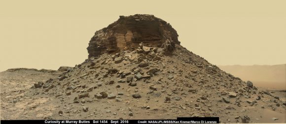
Buttes have also been spotted on other planets in the Solar System, where they are also linked to geological activity and erosion. For example, NASA’s Curiosity rover mission has taken extensive images of the area currently known as the “Murray Buttes” region on Mars, which is located in the lower region of Mount Sharp (in the Gale Crater). In addition, Curiosity has taken drill samples from the surface rock in the region.

Wide-angle mosaic of a butte with sandstone layers showing cross-bedding, in the Murray Buttes region on lower Mount Sharp. Credit: NASA/JPL/MSSS/Ken Kremer/Marco Di Lorenzo

At one time, this crater was believed to be a standing body of water, which was largely responsible for the creation of these features. As Ashwin Vasavada, the Curiosity Project Scientist of NASA’s Jet Propulsion Laboratory, described the area as being “reminiscent of parts of the American southwest because of its butte and mesa landscape. In both areas, thick layers of sediment were deposited by wind and water, eventually resulting in a “layer cake” of bedrock that then began to erode away as conditions changed.  In both places, more resistant sandstone layers cap the mesas and buttes because they protect the more easily eroded, fine-grained rock underneath. ”

Buttes have also been photographed by the Mars Reconnaissance Orbiter’s (MRO) HiRISE instrument. These include the many buttes spotted in the Candor Chasma region – part of the Valles Marineris canyon system – back in 2007. The Viking 1 orbiter also noted the presence of many buttes in the Cydonia region during its flyby in 1976 – the occasion when it took pictures of the “Face of Mars” (later revealed to be a mesa).

Much like polygonal ridges that have been observed in the Medusae Fossae region and other locations across Mars (and Earth), these features are believed to be the remains of volcanic rock that remained in place after the surrounding rock was stripped away by erosion.

Ongoing studies into the various forces that shape our planet has allowed us to understand just how dynamic and changing it is. In addition, developments in space exploration and the planetary sciences have helped us to realize that Earth has a lot in common with other planets in our Solar System.

We have written many articles about geological formations for Universe Today. Here’s What is the Bakken Formation?, What is a Volcanic Neck?, What is the Earth’s Mantle Made Of?, What are Volcanoes?, What is the Difference Between Active and Dormant Volcanoes? and Stunning New Images of Mars from Curiosity Rover.

If you’d like more info on the Butte, check out the U.S. Geological Survey Website. And here’s a link to NASA’s Earth Observatory.

We’ve also recorded an episode of Astronomy Cast all about Plate Tectonics. Listen here, Episode 142: Plate Tectonics.

Sources:

Vortex Coronagraph A Game Changer For Seeing Close In Exoplanets

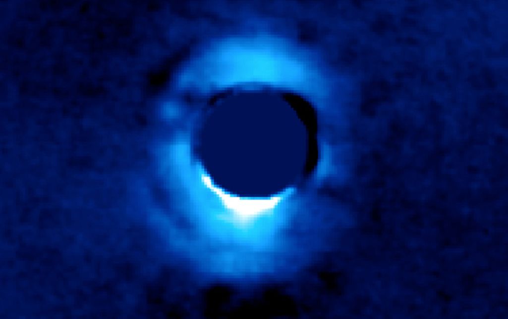
The vortex coronagraph at the Keck Observatory captured this image of the protoplanetary disk surrounding the young star HD 141569. which is about 380 light years from Earth. Image: NASA/JPL-Caltech
The vortex coronagraph at the Keck Observatory captured this image of the protoplanetary disk surrounding the young star HD 141569, which is about 380 light years from Earth. Image: NASA/JPL-Caltech

The study of exoplanets has advanced a great deal in recent years, thanks in large part to the Kepler mission. But that mission has its limitations. It’s difficult for Kepler, and for other technologies, to image regions close to their stars. Now a new instrument called a vortex coronagraph, installed at Hawaii’s Keck Observatory, allows astronomers to look at protoplanetary disks that are in very close proximity to the stars they orbit.

The problem with viewing disks of dust, and even planets, close to their stars is that stars are so much brighter than objects that orbit them. Stars can be billions of times brighter than the planets near them, making it almost impossible to see them in the glare. “The power of the vortex lies in its ability to image planets very close to their star, something that we can’t do for Earth-like planets yet,” said Gene Serabyn of NASA’s Jet Propulsion Laboratory (JPL). “The vortex coronagraph may be key to taking the first images of a pale blue dot like our own.”

“The power of the vortex lies in its ability to image planets very close to their star, something that we can’t do for Earth-like planets yet.” – Gene Serabyn, JPL.

“The vortex coronagraph allows us to peer into the regions around stars where giant planets like Jupiter and Saturn supposedly form,” said Dmitri Mawet, research scientist at NASA’s Jet Propulsion Laboratory and Caltech, both in Pasadena. “Before now, we were only able to image gas giants that are born much farther out. With the vortex, we will be able to see planets orbiting as close to their stars as Jupiter is to our sun, or about two to three times closer than what was possible before.”

Rather than masking the light of stars, like other methods of viewing exoplanets, the vortex coronagraph redirects light away from the detectors by combining light waves and cancelling them out. Because there is no occulting mask, the vortex coronagraph can capture images of regions much closer to stars than other coronagraphs can. Dmitri Mawet, research scientist who invented the new coronagraph, compares it to the eye of a storm.

The vortex mask shown at left is made out of synthetic diamond. When viewed with a scanning electron microscope, right, the "vortex" microstructure of the mask is revealed. Image credit: University of Liège/Uppsala University
The vortex mask shown at left is made out of synthetic diamond. When viewed with a scanning electron microscope, right, the “vortex” microstructure of the mask is revealed. Image credit: University of Liège/Uppsala University

“The instrument is called a vortex coronagraph because the starlight is centered on an optical singularity, which creates a dark hole at the location of the image of the star,” said Mawet. “Hurricanes have a singularity at their centers where the wind speeds drop to zero — the eye of the storm. Our vortex coronagraph is basically the eye of an optical storm where we send the starlight.”

The results from the vortex coronagraph are presented in two papers (here and here) published in the January 2017 Astronomical Journal. One of the studies was led by Gene Serabyn of JPL, who is also head of the Keck vortex project. That study presented the first direct image of HIP79124 B, a brown dwarf that is 23 AU from its star, in the star-forming region called Scorpius-Centaurus.

The vortex coronagraph captured this image of the brown dwarf PIA21417.
The vortex coronagraph captured this image of the brown dwarf PIA21417. Image: NASA/JPL-Caltech

“The ability to see very close to stars also allows us to search for planets around more distant stars, where the planets and stars would appear closer together. Having the ability to survey distant stars for planets is important for catching planets still forming,” said Serabyn.

“Having the ability to survey distant stars for planets is important for catching planets still forming.” – Gene Serabyn, JPL.

The second of the two vortex studies presented images of a protoplanetary disk around the young star HD141569A. That star actually has three disks around it, and the coronagraph was able to capture an image of the innermost ring. Combining the vortex data with data from the Spitzer, WISE, and Herschel missions showed that the planet-forming material in the disk is made up pebble-size grains of olivine. Olivine is one of the most abundant silicates in Earth’s mantle.

“The three rings around this young star are nested like Russian dolls and undergoing dramatic changes reminiscent of planetary formation,” said Mawet. “We have shown that silicate grains have agglomerated into pebbles, which are the building blocks of planet embryos.”

These images and studies are just the beginning for the vortex coronagraph. It will be used to look at many more young planetary systems. In particular, it will look at planets near so-called ‘frost lines’ in other solar systems. The is the region around star systems where it’s cold enough for molecules like water, methane, and carbon dioxide to condense into solid, icy grains. Current thinking says that the frost line is the dividing line between where rocky planets and gas planets are formed. Astronomers hope that the coronagraph can answer questions about hot Jupiters and hot Neptunes.

Hot Jupiters and Neptunes are large gaseous planets that are found very close to their stars. Astronomers want to know if these planets formed close to the frost line then migrated inward towards their stars, because it’s impossible for them to form so close to their stars. The question is, what forces caused them to migrate inward? “With a bit of luck, we might catch planets in the process of migrating through the planet-forming disk, by looking at these very young objects,” Mawet said.

SpaceX Shuffles Falcon 9 Launch Schedule, NASA Gets 1st Launch from Historic KSC Pad 39A

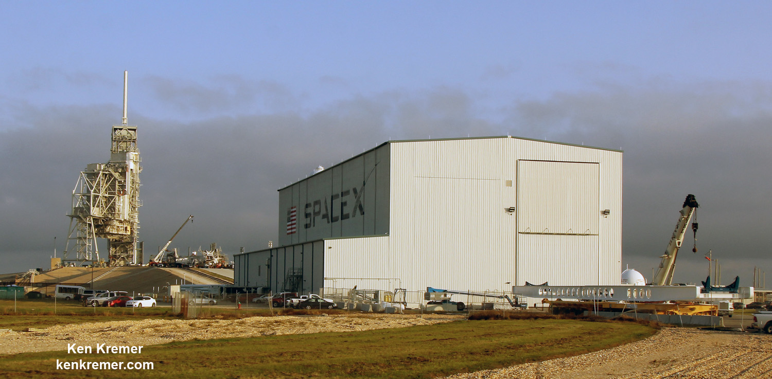
SpaceX is repurposing historic pad 39A at the Kennedy Space Center, Florida for launches of the Falcon 9 rocket. Ongoing pad preparation by work crews is seen in this current view taken on Jan. 27, 2017. Credit: Ken Kremer/kenkremer.com

KENNEDY SPACE CENTER, FL – SpaceX announced Sunday (Jan. 29) a significant shuffle to the Falcon 9 launch schedule, saying that a key NASA mission to resupply the space station is moving to the head of the line and will now be their first mission to launch from historic pad 39A at the Kennedy Space Center – formerly used to launch space shuttles.

The late breaking payload switch will allow SpaceX, founded by billionaire CEO Elon Musk, additional time to complete all the extensive ground support work and pad testing required for repurposing seaside Launch Complex 39A from launching the NASA Space Shuttle to the SpaceX Falcon 9.

Blastoff of the 22-story tall SpaceX Falcon 9 carrying an unmanned Dragon cargo freighter with NASA as customer on the CRS-10 resupply mission to the International Space Station (ISS) could come as soon as mid-February, said SpaceX.

“SpaceX announced today that its first launch from Launch Complex 39A (LC-39A) at NASA’s Kennedy Space Center in Florida will be the CRS-10 mission to the International Space Station,” said SpaceX in a statement.

CRS-10 counts as SpaceX’s tenth cargo flight to the ISS since 2012 under contract to NASA.

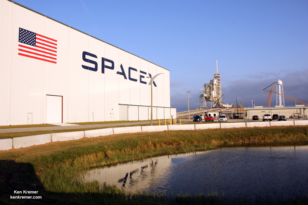
SpaceX is renovating Launch Complex 39A at the Kennedy Space Center for launches of commercial and human rated Falcon 9 rockets as well as the Falcon Heavy, as seen here during Dec 2016 with construction of a dedicated new transporter/erector. Credit: Ken Kremer/kenkremer.com

Crews have been working long hours to modify pad 39A and get it ready for Falcon 9 launches. Also, the newly built transporter erector launcher was seen raised at the pad multiple times in recent days. The transporter will move the rocket horizontally up the incline at the pad, and then erect it vertically.

“This schedule change allows time for additional testing of ground systems ahead of the CRS-10 mission,” SpaceX announced in a statement.

The surprise switch in customers means that the previously planned first Falcon 9 launch from pad 39A of the commercial EchoStar 23 communications satellite is being pushed off to a later date – perhaps late February.

Until now, EchoStar 23 was slated to be the first satellite launched by a Falcon 9 from Launch Complex 39A on NASA’s Kennedy Space Center. It could have come as soon as by the end of this week.

However, the Falcon 9 launch date from pad 39A has slipped repeatedly in January, with this week on Feb. 3 as the most recently targeted ‘No Earlier Than’ NET date.

SpaceX successfully resumed launches of the Falcon 9 earlier this month when the first flock of 10 Iridium NEXT mobile voice and data relay satellites blasted off on the Iridium 1 mission from Vandenberg Air Force Base in California on Jan. 14, 2017.

NASA now gets the first dibs for using pad 39A which has lain dormant for nearly six years since Space Shuttle Atlantis launched on the final shuttle mission STS 135 in July 2011.

SpaceX leased pad 39A from NASA for launches of the Falcon 9 and Falcon Heavy back in April 2014 and was already employing pad 40 on Cape Canaveral Air Force Station for Falcon 9 launches to the ISS.

The last Dragon resupply mission to the ISS blasted off on July 18, 2016 on the CRS-9 mission. The Falcon 9 first stage was also successfully recovered via a propulsive soft landing back at the Cape at night.

SpaceX Falcon 9 launches and lands over Port Canaveral in this streak shot showing rockets midnight liftoff from Space Launch Complex 40 at Cape Canaveral Air Force Station in Florida at 12:45 a.m. EDT on July 18, 2016 carrying Dragon CRS-9 craft to the International Space Station (ISS) with almost 5,000 pounds of cargo and docking port. View from atop Exploration Tower in Port Canaveral. Credit: Ken Kremer/kenkremer.com

The last successful Falcon 9 launch from Space Launch Complex-40 took place on Aug. 14, 2016, carrying the JCSAT-16 Japanese communications satellite to orbit.

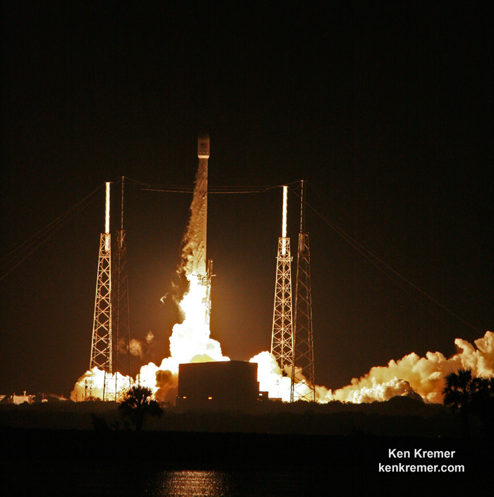
Launch of SpaceX Falcon 9 carrying JCSAT-16 Japanese communications satellite to orbit on Aug. 14, 2016 at 1:26 a.m. EDT from Space Launch Complex 40 at Cape Canaveral Air Force Station, Fl. Credit: Ken Kremer/kenkremer.com

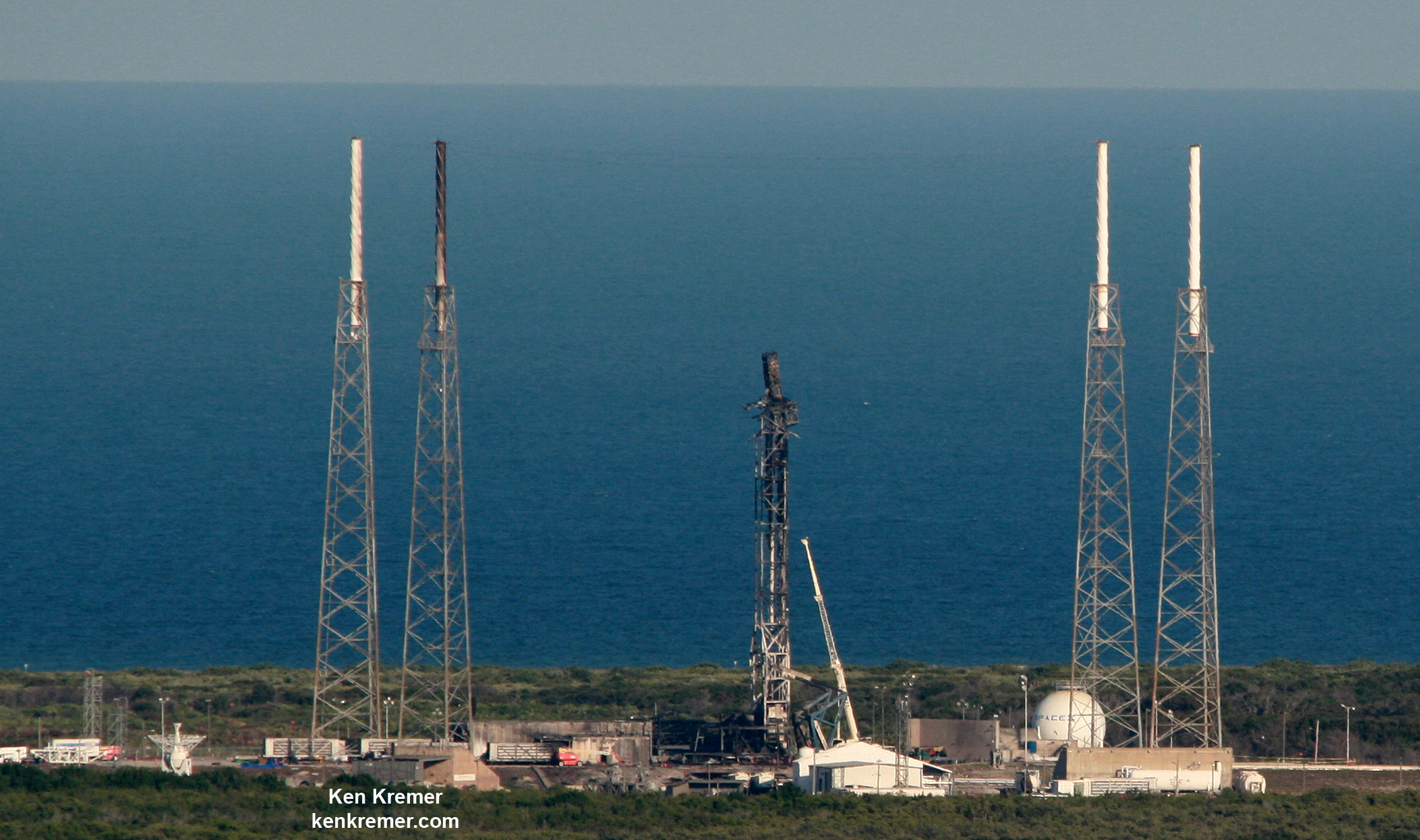
But following the unexpected launch pad explosion on Sept 1, 2016 that completely destroyed a Falcon 9 and the $200 million Amos-6 commercial payload during a prelaunch fueling test, pad 40 suffered extensive damage.

Furthermore it is not known when the pad will be ready to resume launches.

Aerial view of pad and strongback damage at SpaceX Launch Complex-40 as seen from the VAB roof on Sept. 8, 2016 after fueling test explosion destroyed the Falcon 9 rocket and AMOS-6 payload at Cape Canaveral Air Force Station, FL on Sept. 1, 2016. Credit: Ken Kremer/kenkremer.com

So SpaceX has had to switch launch pads for near term future flights and press pad 39A into service much more urgently, and the refurbishing and repurposing work is not yet complete.

To date SpaceX has not rolled a Falcon 9 rocket to pad 39A, not raised it to launch position, not conducted a fueling exercise and not conducted a static fire test. All the fit checks with a real rocket remain to be run.

Thus the current launch target of mid-February for CRS-10 remains a target date and not a firm launch date. EchoStar 23 is next in line.

“The launch is currently targeted for no earlier than mid-February,” SpaceX elaborated.

“Following the launch of CRS-10, first commercial mission from 39A is currently slated to be EchoStar XXIII.”

Once the pad is ready, SpaceX plans an aggressive launch schedule in 2017.

“The launch vehicles, Dragon, and the EchoStar satellite are all healthy and prepared for launch,” SpaceX stated.

The history making first use of a recycled Falcon 9 carrying the SES-10 communications satellite could follow as soon as March, if all goes well.

Incredible sight of pleasure craft zooming past SpaceX Falcon 9 booster from Thaicom-8 launch on May 27, 2016 as it arrives at the mouth of Port Canaveral, FL, atop droneship platform on June 2, 2016. Credit: Ken Kremer/kenkremer.com

Stay tuned here for Ken’s continuing Earth and Planetary science and human spaceflight news.

Ken Kremer

SpaceX crews are renovating Launch Complex 39A at the Kennedy Space Center for launches of commercial and human rated Falcon 9 rockets as well as the Falcon Heavy, as seen here during Dec 2016 with construction of a dedicated new transporter/erector. At new rocket processing hangar sits at left. Credit: Ken Kremer/kenkremer.com