Makemake’s Mysteriously Missing Atmosphere

Artist’s impression of the surface of Makemake, a dwarf planet beyond Pluto (ESO/L. Calçada/Nick Risinger)

It turns out there’s no air up there: the distant dwarf planet Makemake is surprisingly lacking in an atmosphere, according to findings made by astronomers using telescopes at ESO’s La Silla and Paranal observatories.

An international team of astronomers used the mountaintop telescopes to observe Makemake as it passed in front of a faint background star in April 2011, a brief stellar occultation that lasted only about a minute. By watching how the starlight was blotted out by Makemake, measurements could be made of the dwarf planet’s size, mass and atmosphere — or, in this case, its lack thereof… a finding which surprised some scientists.

“As Makemake passed in front of the star and blocked it out, the star disappeared and reappeared very abruptly, rather than fading and brightening gradually. This means that the little dwarf planet has no significant atmosphere,” said team leader José Luis Ortiz of the Instituto de Astrofísica de Andalucía in Spain. “It was thought that Makemake had a good chance of having developed an atmosphere — that it has no sign of one at all shows just how much we have yet to learn about these mysterious bodies.”

First discovered in 2005, Makemake is an icy dwarf planet about 2/3 the diameter of Pluto — and 19 AU further from the Sun (but not nearly as far as the larger Eris, which is over 96 AU away.) It was thought that Makemake might have a tenuous, seasonal atmosphere similar to what has been found on Pluto, but it now appears that it does not… at least not in any large-scale, global form.

Due to its small size, sheer distance and apparent lack of moons, making scientific observations of Makemake has been a challenge for astronomers. The April 2011 occultation allowed measurements to be made — even if only for a minute — that weren’t possible before, including first-ever calculations of the dwarf planet’s density and albedo.

As it turns out, Makemake’s albedo is about 0.77 — comparable to that of dirty snow… a reflectivity higher than Pluto’s but lower than that of Eris. Its density is estimated to be 1.7 ± 0.3 g/cm³, indicating a composition of mostly ice with some rock.

Our new observations have greatly improved our knowledge of one of the biggest [icy bodies], Makemake — we will be able to use this information as we explore the intriguing objects in this region of space further,” said Ortiz.

Read more on the ESO release here.

The team’s research was presented in a paper “Albedo and atmospheric constraints of dwarf planet Makemake from a stellar occultation” to appear in the November 22, 2012 issue of the journal Nature.

Inset image: Makemake imaged by Hubble in 2006. (NASA/JPL-Caltech)

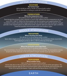
Hunting for High Life: What Lives in Earth’s Stratosphere?

The Moon photographed through the layers of the atmosphere from the ISS in December 2003 (NASA/JSC)

What lives at the edge of space? Other than high-flying jet aircraft pilots (and the occasional daredevil skydiver) you wouldn’t expect to find many living things over 10 kilometers up — yet this is exactly where one NASA researcher is hunting for evidence of life.

Earth’s stratosphere is not a place you’d typically think of when considering hospitable environments. High, dry, and cold, the stratosphere is the layer just above where most weather occurs, extending from about 10 km to 50 km (6 to 31 miles) above Earth’s surface. Temperatures in the lowest layers average -56 C (-68 F) with jet stream winds blowing at a steady 100 mph. Atmospheric density is less than 10% that found at sea level and oxygen is found in the form of ozone, which shields life on the surface from harmful UV radiation but leaves anything above 32 km openly exposed.

Sounds like a great place to look for life, right? Biologist David Smith of the University of Washington thinks so… he and his team have found “microbes from every major domain” traveling within upper-atmospheric winds.

Smith, principal investigator with Kennedy Space Center’s Microorganisms in the Stratosphere (MIST) project, is working to take a census of life tens of thousands of feet above the ground. Using high-altitude weather balloons and samples gathered from Mt. Bachelor Observatory in central Oregon, Smith aims to find out what kinds of microbes are found high in the atmosphere, how many there are and where they may have come from.

“Life surviving at high altitudes challenges our notion of the biosphere boundary.”

– David Smith, Biologist, University of Washington in Seattle

Although reports of microorganisms existing as high as 77 km have been around since the 1930s, Smith doubts the validity of some of the old data… the microbes could have been brought up by the research vehicles themselves.

“Almost no controls for sterilization are reported in the papers,” he said.

But while some researchers have suggested that the microbes could have come from outer space, Smith thinks they are terrestrial in origin. Most of the microbes discovered so far are bacterial spores — extremely hardy organisms that can form a protective shell around themselves and thus survive the low temperatures, dry conditions and high levels of radiation found in the stratosphere. Dust storms or hurricanes could presumably deliver the bacteria into the atmosphere where they form spores and are transported across the globe.

If they land in a suitable environment they have the ability to reanimate themselves, continuing to survive and multiply.

Although collecting these high-flying organisms is difficult, Smith is confident that this research will show how such basic life can travel long distances and survive even the harshest environments — not only on Earth but possibly on other worlds as well, such as the dessicated soil of  Mars.

“We still have no idea where to draw the altitude boundary of the biosphere,” said Smith. This research will “address how long life can potentially remain in the stratosphere and what sorts of mutations it may inherit while aloft.”

Read more on Michael Schirber’s article for Astrobiology Magazine here, and watch David Smith’s seminar “The High Life: Airborne Microbes on the Edge of Space” held May 2012 at the University of Washington below:

Inset images – Top: layers of the atmosphere, via the Smithsonian/NMNH. Bottom: Scanning electron microscope image of atmospheric bacterial spores collected from Mt. Bachelor Observatory (NASA/KSC)

Pictures From T-86: Cassini’s Latest Flyby of Titan

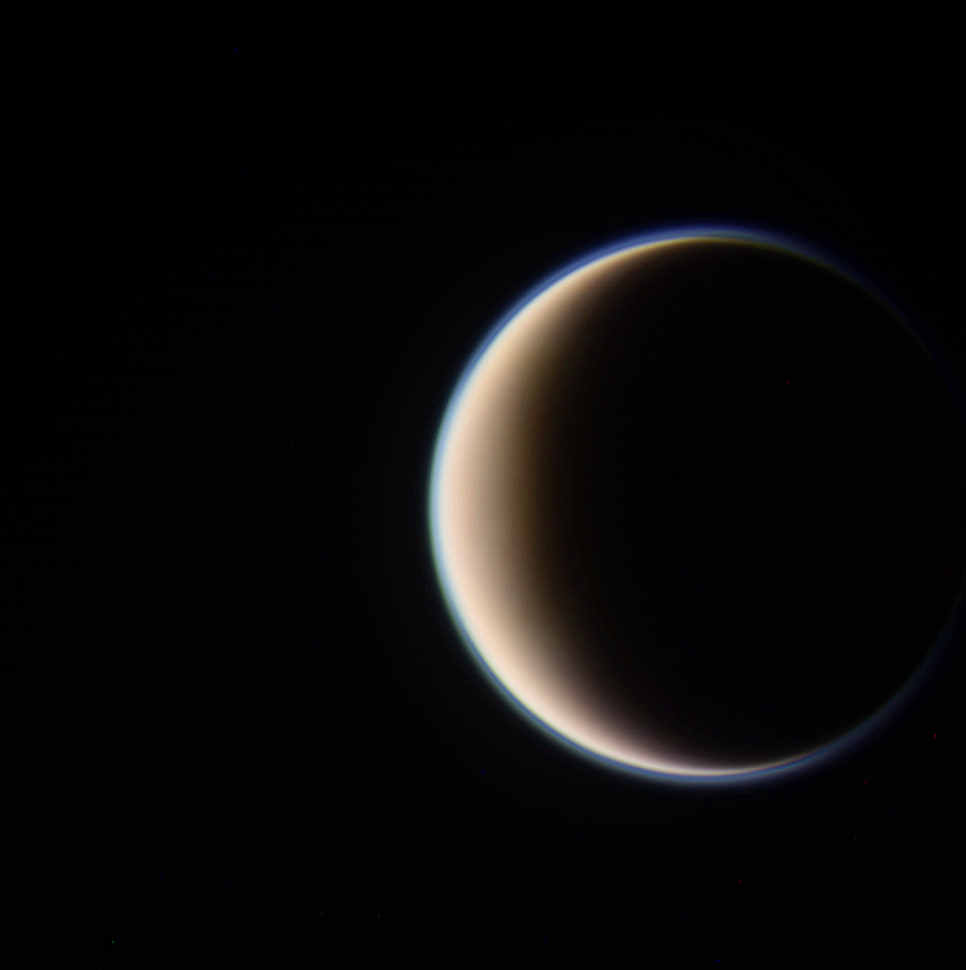
On September 26-27 Cassini executed its latest flyby of Titan, T-86, coming within 594 miles (956 km) of the cloud-covered moon in order to measure the effects of the Sun’s energy on its dense atmosphere and determine its variations at different altitudes.

The image above was captured as Cassini approached Titan from its night side, traveling about 13,000 mph (5.9 km/s). It’s a color-composite made from three separate raw images acquired in red, green and blue visible light filters.

Titan’s upper-level hydrocarbon haze is easily visible as a blue-green “shell” above its orange-colored clouds.

Cassini captured this image as it approached Titan’s sunlit limb, grabbing a better view of the upper haze. Some banding can be seen in its highest reaches.

The haze is the result of UV light from the Sun breaking down nitrogen and methane in Titan’s atmosphere, forming hydrocarbons that rise up and collect at altitudes of 300-400 kilometers. The sea-green coloration is a denser photochemical layer that extends upwards from about 200 km altitude.

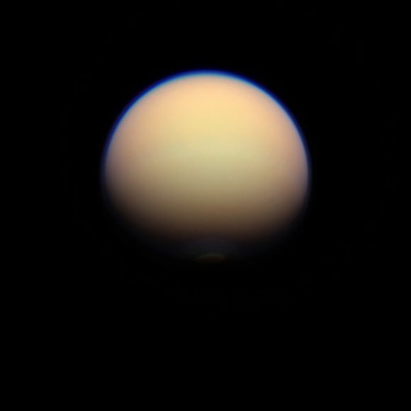
In this image, made from data acquired on Sept. 27, Titan’s south polar vortex can be made out just within the southern terminator. The vortex is a relatively new feature in Titan’s atmosphere, first spotted earlier this year. It’s thought that it’s a region of open-cell convection forming above the moon’s pole, a result of the approach of winter to Titan’s southern half.

Read: Cassini Spots Surprising Swirls Above Titan’s South Pole

This T-86 flyby was was one of a handful of opportunities to profile Titan’s ionosphere from the outermost edge of Titan’s atmosphere. In addition Cassini was able to look for any changes to Ligeia Mare, a methane lake last observed in spring of 2007.

Now that Titan has been under scrutiny for a full year of Saturn’s seasons — which lasts 29.7 Earth-years — astronomers now know that varying amounts of solar radiation can drastically change situations both within Saturn’s atmosphere and on its surface.

“As with Earth, conditions on Titan change with its seasons. We can see differences in atmospheric temperatures, chemical composition and circulation patterns, especially at the poles,” said Dr. Athena Coustenis from the Paris-Meudon Observatory in France. “For example, hydrocarbon lakes form around the north polar region during winter due to colder temperatures and condensation. Also, a haze layer surrounding Titan at the northern pole is significantly reduced during the equinox because of the atmospheric circulation patterns. This is all very surprising because we didn’t expect to find any such rapid changes, especially in the deeper layers of the atmosphere.”

“It’s amazing to think that the Sun still dominates over other energy sources even as far out as Titan, over 1.5 billion kilometres from us.”
– Dr. Athena Coustenis, Paris-Meudon Observatory

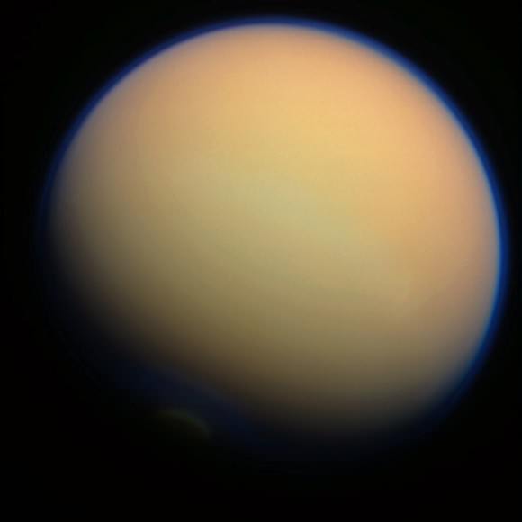
The image above, acquired on Sept. 28, was added to this post on Oct. 1. It was taken from a distance of  649,825 miles (1,045,792 kilometers.)

Cassini’s next targeted approach to Titan — T-87 — will occur on November 13.

Get more news from the Cassini mission here.

Image credits: NASA/JPL/Space Science Institute. All color composites by Jason Major. Images have not been validated or calibrated by the SSI team.


(Do you love the Cassini mission as much as we do? Vote on your favorite Cassini “Shining Moment” here, in honor of the 15th anniversary of Cassini’s launch on October 15! Amazing to think it’s already been 15 years — 8 of those in orbit around Saturn!)

On the Hunt for High-Speed Sprites

Air glow (along with a lightning sprite) is visible in this image from the International Space Station. Credit: NASA

A bright red sprite appears above a lightning flash in a photo captured from the ISS

Back on April 30, Expedition 31 astronauts aboard the ISS captured this photo of a red sprite hovering above a bright flash of lightning over Myanmar. Elusive atmospheric phenomena, sprites are extremely brief bursts of electromagnetic activity that are associated with powerful lightning discharges, but exactly how and why they form isn’t yet known — although recent research (along with some incredible high-speed video) is shedding new light on sprites.

Although the appearance of bright high-altitude flashes above thunderstorms have been reported by pilots for nearly a century, it wasn’t until 1989 that a sprite was captured on camera — and the first color image of one wasn’t taken until 1994.

So-named because of their elusive nature, sprites appear as several clusters of red tendrils above a lighting flash followed by a breakup into smaller streaks, often extending as high as 55 miles (90 km) into the atmosphere. The brightest region of a sprite is typically seen at altitudes of 40-45 miles (65-75 km).

Because they occur above storms, only last for a thousandth of a second and emit light in the red portion of the visible spectrum (to which our eyes are the least sensitive) studying sprites has been notoriously difficult for atmospheric scientists. Space Station residents may get great views but they have lots of other things to do in the course of their day besides sprite hunting! Luckily, a team of scientists were able to capture some unprecedented videos of sprites from airplanes in the summer of 2011, using high-speed cameras and help from Japan’s NHK television.

Chasing storms over Denver via plane for two weeks, researchers were able to locate “hot zones” of sprites and capture them on camera from two planes flying 12 miles apart. Combining their videos with ground-based measurements they were able to create 3-dimensional maps of the formation and evolution of individual sprites.

Based on the latest research, it’s suggested that sprites form as a result of a positive electrical charge within a lightning strike that reaches the ground, which leaves the top of the cloud negatively charged — a one-in-ten chance that then makes conditions above the cloud “just right” for a sprite to form higher in the atmosphere.

“Seeing these are spectacular,” said Hans C. Stenbaek-Nielsen, a geophysicist at the University of Alaska in Fairbanks, Alaska, where much sprite research has been conducted. “But we need the movies, because not only are they so fast that you could blink and miss them, but they emit most of their light in red, where the human eye is relatively blind.”

An example of how energy can be exchanged between lower and higher regions of Earth’s atmosphere, it’s been suggested that sprites could also be found on other planets as well, and may provide insight into the exotic chemistries of alien atmospheres.

Read more on NASA Heliophysics here.

Main image: Image Science & Analysis Laboratory, NASA Johnson Space Center. Inset image: the first color image of a sprite  (NASA/UAF.) Video: NHK.

Bolt from the Blue: Giant Flash of Lightning Seen in Saturn’s Storm

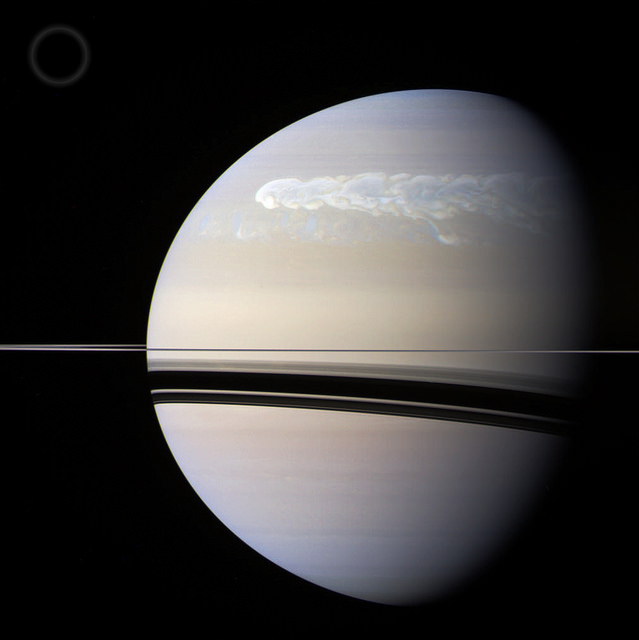
An enormous storm that wrapped its way around Saturn’s northern hemisphere during the first half of 2011 wasn’t just a churning belt of high-speed winds; it also generated some monster flashes of lightning as well — one of which was captured on camera by the Cassini spacecraft!

Check it out…


The image above was created from Cassini raw images acquired in red, green, and blue color channels and assembled to create a somewhat “true-color” image of Saturn. The image shows the storm as it looked on February 25, 2011, a couple of months after it was first noticed by amateur astronomers on the ground. (The circle at upper left illustrates the comparative size of Earth.)

Read: Studying Saturn’s Super Storm

These images were acquired by Cassini almost two weeks later, on March 6, the first showing a bright blue flash of lightning within the storm, along the eastern edge of a large eddy. The second image, taken 30 minutes later, does not have any visible flash.

Because the flash was only visible in blue light (and there was no red channel data) the images are false color. Near-infrared replaced the visible red channel.

Based on the image resolution (12 miles/20 km per pixel) the size of the lightning flash is estimated to be about 120 miles (200 km) wide — as large as the strongest lightning seen on Earth. And like on Earth, Saturn’s lightning is thought to originate deeper in the atmosphere, at the level where water droplets freeze.

Although the 2011 northern storm was a great feature to observe, this wasn’t the first time lightning had been spotted on Saturn. Cassini had observed flashes on the ringed planet in August of 2009 as well, allowing scientists to create the first movie of lightning flashing on another planet.

Since its arrival at Saturn in 2004, Cassini has detected 10 lightning storms on Saturn — although with up to 10 flashes per second and eventually covering an area of 2 billion square miles (4 billion sq. km) the 2011 storm was by far the largest ever seen.

Image credits: NASA / JPL-Caltech / Space Science Institute. Top composite by J. Major. Video: JPL

Pacific Glory

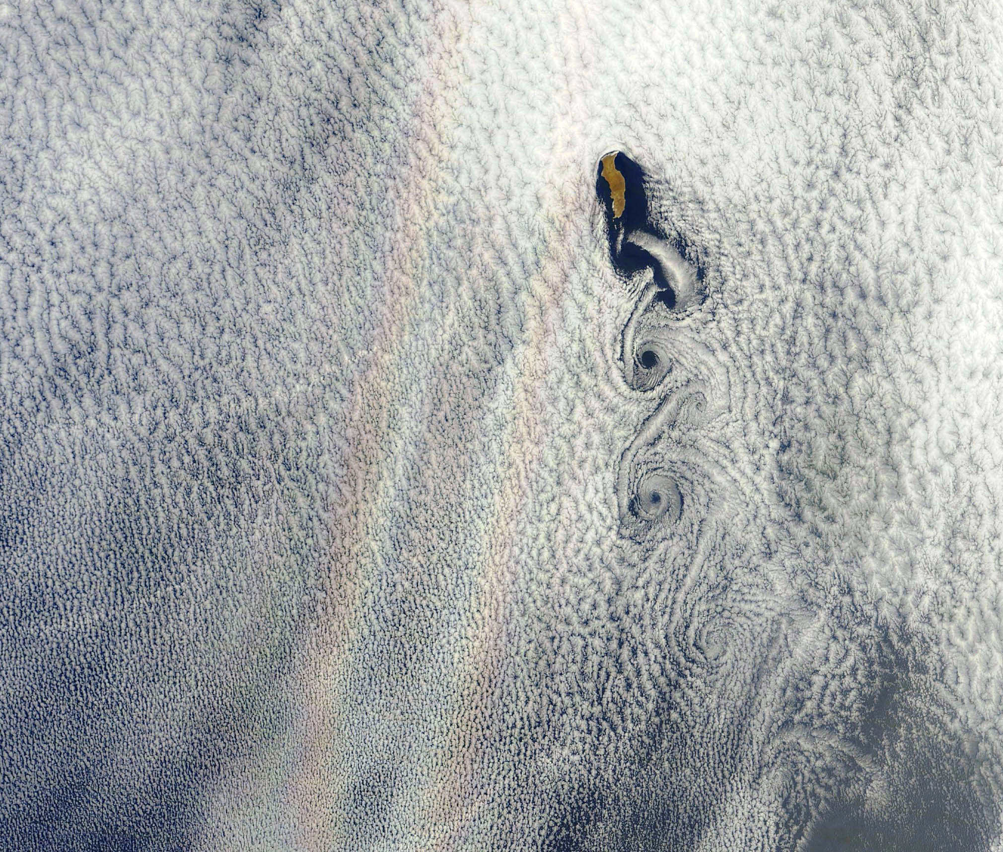
An optical phenomenon known as a “glory” is seen over a cloud-covered Pacific Ocean in this image from NASA’s Aqua satellite, acquired on June 20, 2012. Although the colors may make it look like a rainbow, the process behind its formation is somewhat different.

As vortices spiral off the leeward side of Guadalupe Island, off the western coast of Baja California, a shimmering spectrum of colors highlights a glory just west of the island. Glories are created when light from the Sun reflects back toward an observer off water droplets within clouds or fog. They are often seen from airplanes as a bright ring of light encircling a silhouetted shadow of the aircraft below, but are also visible from the ground and, sometimes, even from space.

From the NASA Earth Observatory website:

Although glories may look similar to rainbows, the way light is scattered to produce them is different. Rainbows are formed by refraction and reflection; glories are formed by backward diffraction. The most vivid glories form when an observer looks down on thin clouds with droplets that are between 10 and 30 microns in diameter. The brightest and most colorful glories also form when droplets are roughly the same size.

From the ground or an airplane, glories appear as circular rings of color. The space shuttle Columbia observed a circular glory from space in 2003. In the image above, however, the glory does not appear circular. That’s because MODIS scans the Earth’s surface in swaths perpendicular to the path followed by the satellite. And since the swaths show horizontal cross sections through the rings of the glory, the glory here appears as two elongated bands of color that run parallel to the path of the satellite, rather than a full circle.

Glories always appear around the spot directly opposite the Sun, from the perspective of the viewer. This spot is called the anti-solar point. To visualize this, imagine a line connecting the Sun, a viewer, and the spot where the glory appears. In this case, the anti-solar point falls about halfway between the two colored lines of the glory.

Click here to download the full-size image.

NASA image courtesy Jeff Schmaltz, LANCE MODIS Rapid Response. Read more here.

There’s a Hole in the Sky!

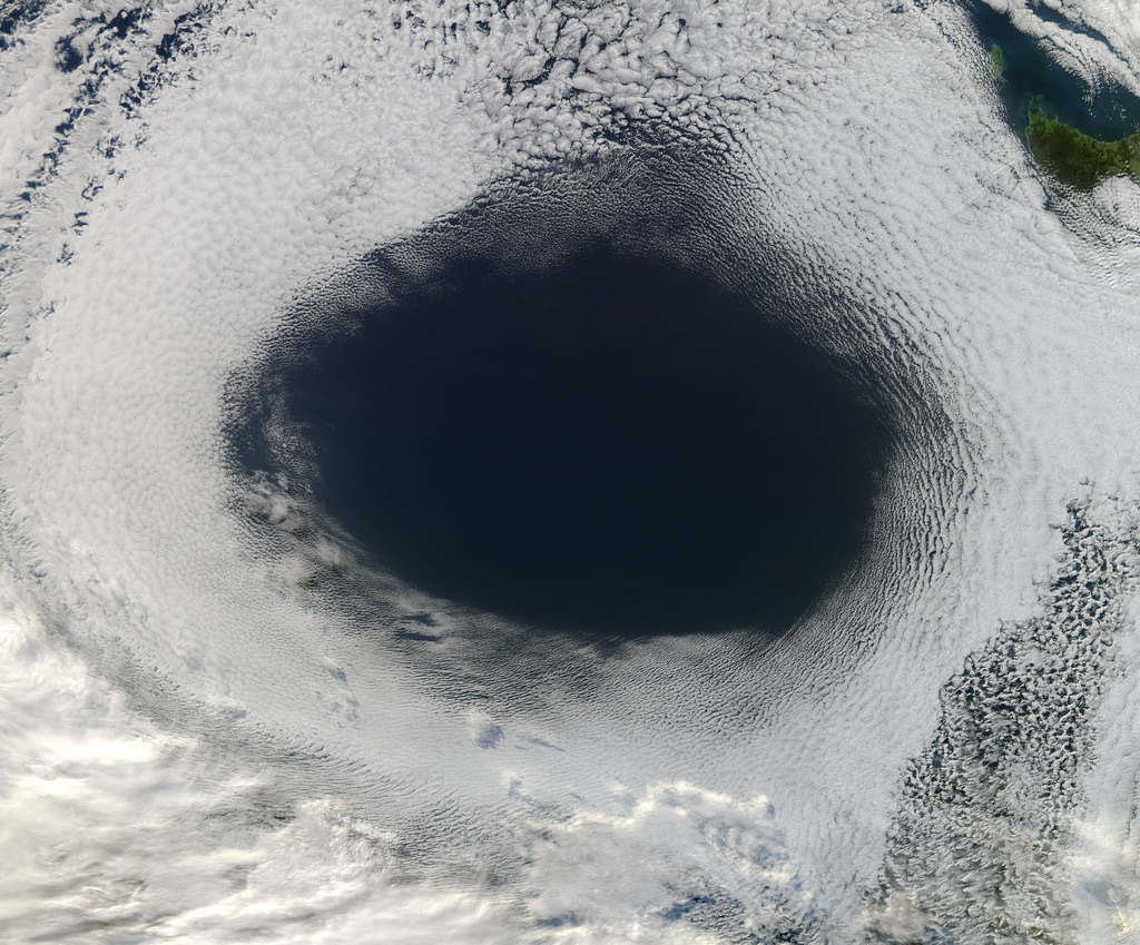
A vast hole in the cloud cover seen over the southern Pacific

[/caption]

Well, not the sky exactly, but definitely in the clouds!

This image, acquired by NASA’s Aqua satellite on June 5, shows an enormous oval hole in the clouds above the southern Pacific Ocean, approximately 500 miles (800 km) off the southwestern coast of Tasmania. The hole itself is several hundred miles across, and is the result of high pressure air in the upper atmosphere.

According to Rob Gutro of NASA’s Goddard Space Flight Center, “This is a good visible example of how upper-level atmospheric features affect the lower atmosphere, because the cloud hole is right under the center of a strong area of high pressure. High pressure forces air down to the surface blocking cloud formation. In addition, the altocumulus clouds are rotating counter-clockwise around the hole, which in the southern hemisphere indicates high pressure.”

The northwestern tip of Tasmania and King Island can be seen in the upper right of the image.

The Aqua mission is a part of the NASA-centered international Earth Observing System (EOS). Launched on May 4, 2002, Aqua has six Earth-observing instruments on board, collecting a variety of global data sets about the Earth’s water cycle. Read more about Aqua here.

On the Edge of Titan

Titan's haze-covered limb seen by Cassini on June 6

[/caption]

Here’s a quick look at one of my favorite cosmic photo subjects – the varying layers of atmosphere that enshroud Saturn’s enormous moon Titan. The image above is a color-composite made from three raw images acquired by Cassini during its latest flyby.

On June 7 Cassini approached Titan within 596 miles (959 km) and imaged portions of the moon’s northwest quadrant with its radar instrument, as well as conducted further investigations of areas near the equator where surface changes were detected in 2010.

The image here was assembled from three raw images captured in red, green and blue visible light channels. It reveals some structure in the upper hydrocarbon haze layers that extend upwards above the moon’s opaque orange clouds — reaching 400-500 km in altitude, Titan’s atmosphere is ten times thicker than Earth’s!

The June 6 flyby was the second in a series of passes that will take Cassini into a more inclined orbit, where it will reside for the next three years as it investigates Saturn’s polar regions and obtains better views of its ring system.

Read more about the flyby here.

Image: NASA/JPL/Space Science Institute. Composite by J. Major.

On The Hunt For High-Altitude Microorganisms

Design of an XCOR Lynx spacecraft (XCOR Aerospace)

[/caption]

The United States Rocket Academy has announced an open call for entries in its High Altitude Astrobiology Challenge, a citizen science project that will attempt to collect samples of microbes that may be lurking in Earth’s atmosphere at the edge of space.

Earth’s biosphere has been discovered to extend much higher than once thought — up to 100,000 feet (30,480 meters) above the planet’s surface. Any microorganisms present at these high altitudes could be subject to the mutating effects of increased radiation and transported around the globe in a sort of pathogenic jet-stream.

What sort of microbes may exist at the upper reaches of the atmosphere?

Citizens in Space, a project run by the U.S. Rocket Academy, is offering a $10,000 prize for the development of an open-source and replicable  collection device that could successfully retrieve samples of high-altitude microorganisms, and could fly as a payload aboard an XCOR Lynx spacecraft.

XCOR Aerospace is a private California-based company that has developed the Lynx, a reusable launch vehicle that has suborbital flight capabilities. Low-speed test flights are expected to commence later this year, with incremental testing to take place over the following months.

Any proposed microbe collection devices would have to fit within the parameters of the Lynx’s 2kg Aft Cowling Port payload capabilities — preferably a 10 x 10 x 20 cm CubeSat volume — and provide solutions for either its retraction (in the case of extended components) or retrieval (in the case of ejected hardware.)

The contest is open to any US resident or non-government team or organization, and submissions are due by February 13, 2013. The chosen design will fly on 10 contracted Lynx flights in late 2013 or early 2014, and possibly even future missions.

Find out more about the challenge on the Citizens in Space site here, and check out an animation of the XCOR Lynx spacecraft below:

Antarctica’s Ice Being Eaten Away From Below

The 820-foot-wide crack in Antarctica's Pine Island Glacier, seen from DC-8 during Operation IceBridge (Credit: NASA/DMS)


Data collected from a NASA ice-watching satellite reveal that the vast ice shelves extending from the shores of  western Antarctica are being eaten away from underneath by ocean currents, which have been growing warmer even faster than the air above.

The animation above shows the circulation of ocean currents around the western Antarctic ice shelves. The shelf thickness is indicated by the color; red is thicker (greater than 550 meters), while blue is thinner (less than 200 meters).

Launched in January 2003, NASA’s ICESat (Ice, Cloud and land Elevation Satellite) studied the changing mass and thickness of Antarctica’s ice from its location in polar orbit. An international research team used over 4.5 million surface height measurements collected by ICESat’s GLAS (Geoscience Laser Altimeter System) instrument from Oct. 2005 to 2008. They concluded that 20 of the 54 shelves studied — nearly half — were losing thickness from underneath.

[/caption]

Most of the melting ice shelves are located in west Antarctica, where the flow of inland glaciers to the sea has also been accelerating — an effect that can be compounded by thinning ice shelves which, when grounded to the offshore seabed, serve as dams to hold glaciers back.

Melting of ice by ocean currents can occur even when air temperature remains cold, maintaining a steady process of ice loss — and eventually increased sea level rise.

“We can lose an awful lot of ice to the sea without ever having summers warm enough to make the snow on top of the glaciers melt,” said Hamish Pritchard of the British Antarctic Survey in Cambridge and the study’s lead author . “The oceans can do all the work from below.”

The study also found that Antarctica’s winds are shifting in response to climate change.

“This has affected the strength and direction of ocean currents,” Pritchard said. “As a result warm water is funnelled beneath the floating ice. These studies and our new results suggest Antarctica’s glaciers are responding rapidly to a changing climate.”

ICESat completed operations in 2010 and was decommissioned in August of that year. Its successor ICESat-2 is anticipated to launch in 2016.

Read more on NASA’s news release here.

Animation credit: NASA/Goddard CGI Lab