Types of Clouds

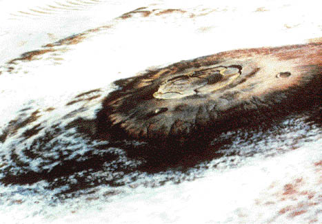
Clouds around Olympus Mons

][/caption]

There are numerous types of clouds, but they are generally classified differently. Some organizations classify them into two main groups while others organize them into three or four groups or even more. The National Weather Service divides clouds into three groups – low, medium, and high clouds.  In meteorology, there are 27 types of clouds with nine in each of the three categories – low, medium, and high.

The lowest level is between the surface and up to two kilometers in the atmosphere. Low level clouds include cumulus, stratocumulus, stratus, and cumulonimbus clouds. Cumulus clouds are one of the most well known types. They are the puffy clouds that look like sheep or clumps of cotton balls. They usually occur where warm air rises and forms condensation when it hits cool air. Stratocumulus clouds are also rounded clouds, but they are darker than cumulus clouds. Stratus clouds are flatter and more horizontal. They are the type of clouds that makes a day seem hazy and cloudy.

The medium level is measured at different elevations depending on the region. This depends on a number of factors including elevation and weather. In the polar region, the middle clouds are between two and four kilometers high; in the temperate regions, these clouds are between two and seven kilometers. They are between two and eight kilometers high in the tropical regions. The mid level clouds are altocumulus, altostratus, and nimbostratus. Altocumulus clouds are somewhat patchy, round forms that are white or grey. The often come before a cold front and also predict thunderstorms. Because these clouds look darker they can seem intimidating.

Altostratus clouds are part of the stratus family of clouds. They are like a sheet of clouds somewhere in between the nimbostratus and cirrostratus in color and often turn the whole sky grey. The nimbostratus clouds are very dark grey sheets of clouds. They look similar to other stratus types, but are much darker.

High altitude clouds are also located at different heights depending on region. They can be found between three and 18 kilometers depending on the region. They are found at a much higher altitude in the tropical regions. The clouds at high altitudes are different cirrus clouds and include cirrus, cirrocumulus, and cirrostratus clouds. Cirrus clouds are the thin, wispy clouds found high in the atmosphere. Because of their thin appearance, they are sometimes called mare’s tail; these clouds form when ice vapor freezes high in the sky. Cirrocumulus clouds appear to be a sheet of tiny cumulus clouds, so they almost look as though they are ripples on a pond. Cirrostratus clouds are a mix between cirrus and stratus clouds. They are thin, but resemble a sheet like stratus clouds. Often, they appear to form a halo around the Sun because they are so thin.

Universe Today has articles on stratus clouds and cloud types.

For more information, check out cloud classifications and types of clouds.

Astronomy Cast has an episode on Earth you will want to check out.

How are Clouds Formed?

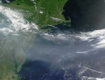
Atmospheric Pollution
Particulates from pollution mixing with clouds above the US (NASA)

[/caption]I bet some of you are fascinated with certain cloud formations. My eldest son once pointed to the sky, excited upon seeing a bunch of clouds taking shape of a menacing dragon. He was however disappointed after a few minutes when the dragon cloud slowly began to deform and fuse with the rest. So how are clouds formed?

First, water evaporates, rises, and fills up the atmosphere. The evaporated water, a.k.a. water vapor then clings to other numerous particles or dust found in the atmosphere. This dust comes from automobiles, fires, volcanoes, bacteria, and sea spray.

As water vapor rises, it cools. Now, the lower the temperature of air, its capacity to hold water vapor (also known as the saturation point of air) also drops.

Eventually, the rising water vapor condenses and forms the structure of the cloud. You can’t however see this structure unless it has its own color. Well, we know that clouds are either white or dark, and that’s why we’re able to see them.

Most clouds are white. That’s because water and ice particles that make up a cloud have just the right amount and sizes to scatter light in all possible wavelengths. When light of practically all wavelengths combine, the result is white light.

However, when too many water and ice particles build up, just like in a storm cloud, much of the scattered light is simply re-scattered into the cloud. In other words, too much particles prevent some of the light from escaping. Hence is the reason why storm clouds are dark.

Try slowly adding milk in water and notice how its color slowly shifts from white to dark as more milk is added.

I’m sure you’ve noticed that clouds easily form on mountains. How are clouds formed on mountains? When a wall of air and water vapor encounters a mountain side, it has nowhere else to go but up the slopes. Well, if you recall, rising water vapor cools and eventually condenses to form clouds.

Thus, mountains don’t have special particles that enhance cloud formation. Rather, it is the barriers that they so form that forces the water vapor to rise and hence develop into cloud structures. A cloud formed due to topographical features is called an orographic cloud.

We’ve got lots of articles about clouds here in Universe Today. For starters, here are two:
Cloud Types
Cirrus Clouds

Here are the links of two more articles from National Oceanic and Atmospheric Administration (NOAA):
Cloud Classifications and Characteristics
Western Region Technical Attachment
Here are two episodes at Astronomy Cast that you might want to check out as well:
Orbit of the Planets, Green Stars, and Oort Cloud Contamination
Sky Surveys

What are Cumulonimbus Clouds?

Cumulonimbus clouds. Credit: NASA

Cumulonimbus clouds are a type of cumulus cloud associated with thunder storms and heavy precipitation. They are also a variation of nimbus or precipitation bearing clouds. They are formed beneath 20,000 ft. and are relatively close to the ground. This is why they have so much moisture. Cumulonimbus clouds are also known as thunderheads due to their unique mushroom shape.

These clouds often produce lightning in their heart. This is caused by ionized droplets in the clouds rubbing against each other. The static charge built up create lightning. Cumulonimbus clouds need warm and humid conditions to form. This gives them the moist warm updrafts needed to produce them. In some instances a Thunderhead with enough energy can develop into a supercell which can produce strong winds, flash floods, and a lot of lightning. Some can even become tornadoes given the right conditions.

Despite the heavy rainfall these clouds produce, the precipitation normally just lasts for around 20 minutes. This is because the clouds require not only a lot of energy to form but also expend a lot energy. However, there are exceptions to the rule. There are also dry thunderstorms which are cumulonimbus clouds whose precipitation does not touch the ground. This type is common in the Western United States where the land is more arid. It is often cited as a cause of wild fires.

An overlooked result of Cumulonimbus clouds are flash floods. This was proven recently in Atlanta, Georgia area of the United States. The state had gone through a two year drought and water supplies such as creeks and rivers were low. However the fall season brought with it the end of the drought and a lot of Thunderstorms. Even though Atlanta is not near any major waterways, the resulting flash floods were on a scale seen only with areas near major rivers with wide flood plains. This demonstrates how much precipitation that Cumulonimbus clouds can produce even in a short amount of time.

Cumulonimbus clouds are a perfect example of how difference in altitude can affect the formation of clouds. Cumulonimbus clouds form in the lower part of the troposphere, the layer of the atmosphere closest to the surface of the Earth. This region due to evaporation and the greenhouse effect produces alot of the warm updrafts that make creation of cumulus and cumulonimbus clouds possible. The turbulence created by the friction between air and the surface of the Earth combined with stored heat from the sun helps to drive the majority of weather.

If you enjoyed this article there are others on Universe Today that you will be sure to enjoy. There is a great article on cloud types and another on the composition of the Earth’s atmosphere.

There are also great resources online. USA today has a great article on cloud types. You can also check out the cloud types website for the University of Illinois.

You can also check out Astronomy Cast. Episode 151 is about atmospheres.