NASA Discovers Salty Liquid Water Flows Intermittently on Mars Today, Bolstering Chance for Life

These dark, narrow, 100 meter-long streaks called recurring slope lineae flowing downhill on Mars are inferred to have been formed by contemporary flowing water. However, a new study by planetary scientists indicates that these may actually be the result of dry flows. Credits: NASA/JPL/University of Arizona

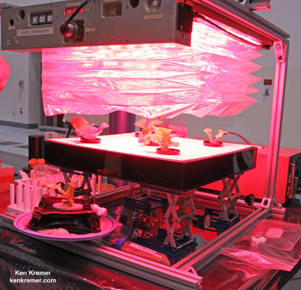
These dark, narrow, 100 meter-long streaks called recurring slope lineae flowing downhill on Mars are inferred to have been formed by contemporary flowing water. Recently, planetary scientists detected hydrated salts on these slopes at Hale crater, corroborating their original hypothesis that the streaks are indeed formed by liquid water. The blue color seen upslope of the dark streaks are thought not to be related to their formation, but instead are from the presence of the mineral pyroxene.

The image is produced by draping an orthorectified Infrared-Red-Blue/Green(IRB)) false color image on a Digital Terrain Model (DTM). This model was produced by researchers at the University of Arizona, much like the High Resolution Imaging Science Experiment (University of Arizona). The vertical exaggeration is 1.5.

NASA and Mars planetary scientists announced today (Sept. 28) that salty “liquid water flows intermittently” across multiple spots on the surface of today’s Mars – trumpeting a major scientific discovery with far reaching implications regarding the search for life beyond Earth and bolstering the chances for the possible existence of present day Martian microbes.

Utilizing spectroscopic measurements and imaging gathered by NASA’s Mars Reconnaissance Orbiter (MRO), researchers found the first strong evidence confirming that briny water flows on the Red Planet today along dark streaks moving downhill on crater slopes and mountain sides, during warmer seasons.

“Mars is not the dry, arid planet that we thought of in the past. Today we announce that under certain circumstances, liquid water has been found on Mars,” said Jim Green, NASA Planetary Science Director at NASA Headquarters, at a media briefing held today, Sept 28.

“When you look at Earth, water is an essential ingredient. Everywhere we go where there’s liquid water, whether its deep in the Earth or in the arid regions, we find life. This is tremendously exciting.”

“We haven’t been able to answer the question – does life exist beyond Earth? But following the water is a critical element of that. We now have great opportunities to be in the right locations on Mars to thoroughly investigate that,” Green elaborated.

“Water! Strong evidence that liquid water flows on present-day Mars,” NASA officials tweeted about the discovery.

The evidence comes in the form of the detection of mysterious dark streaks, as long as 100 meters, showing signatures of hydrated salt minerals periodically flowing in liquid water down steep slopes on the Red Planet that “appear to ebb and flow over time.”

The source of the water is likely from the shallow subsurface or possibly absorbed from the atmosphere.
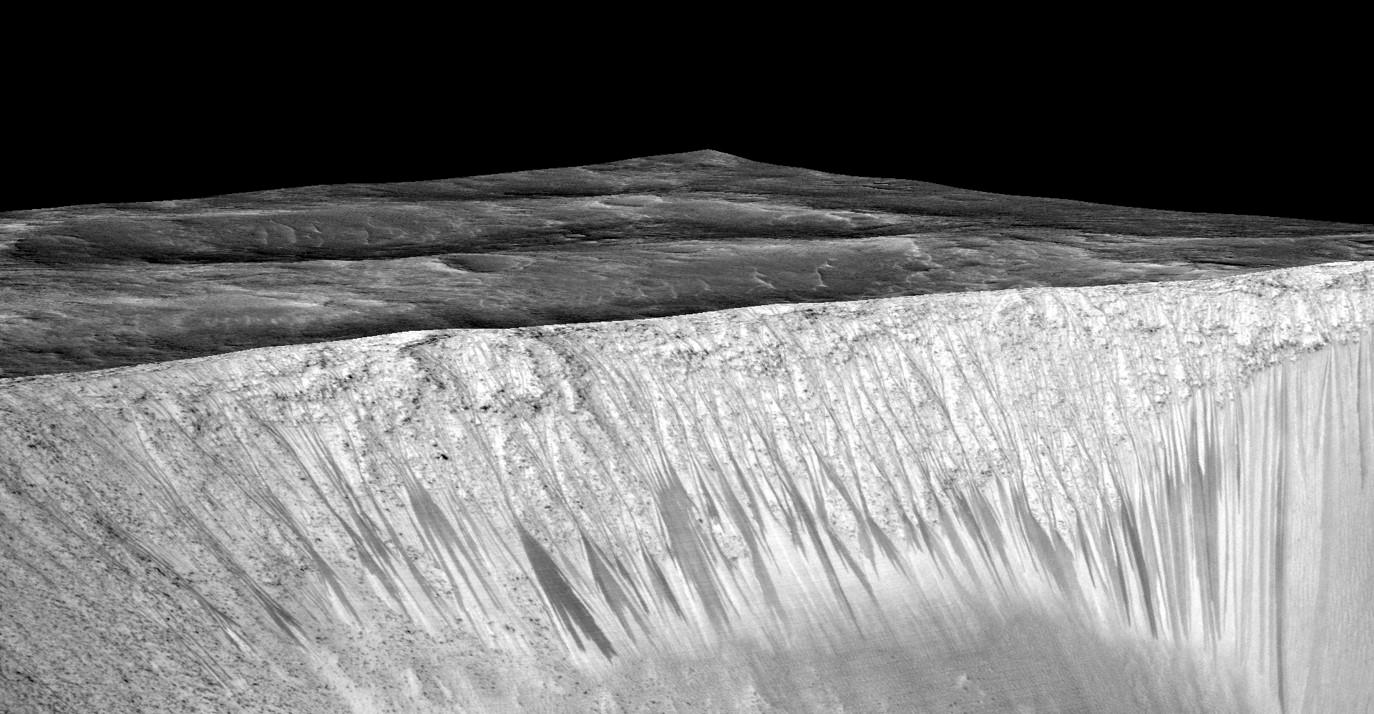
Dark narrow streaks called recurring slope lineae emanating out of the walls of Garni crater on Mars. The dark streaks here are up to few hundred meters in length. They are hypothesized to be formed by flow of briny liquid water on Mars. The image is produced by draping an orthorectified (RED) image (ESP_031059_1685) on a Digital Terrain Model (DTM) of the same site produced by High Resolution Imaging Science Experiment (University of Arizona). Vertical exaggeration is 1.5.    Credits: NASA/JPL/University of Arizona
Dark narrow streaks called recurring slope lineae emanating out of the walls of Garni crater on Mars. The dark streaks here are up to few hundred meters in length. They are hypothesized to be formed by flow of briny liquid water on Mars. The image is produced by draping an orthorectified (RED) image (ESP_031059_1685) on a Digital Terrain Model (DTM) of the same site produced by High Resolution Imaging Science Experiment (University of Arizona). Vertical exaggeration is 1.5. Credits: NASA/JPL/University of Arizona

Water is a key prerequisite for the formation and evolution of life as we know it. So the new finding significantly bolsters the chances that present day extant life could exist on the Red Planet.

“Our quest on Mars has been to ‘follow the water,’ in our search for life in the universe, and now we have convincing science that validates what we’ve long suspected,” said John Grunsfeld, astronaut and associate administrator of NASA’s Science Mission Directorate in Washington.

“This is a significant development, as it appears to confirm that water — albeit briny — is flowing today on the surface of Mars.”

“This increases the chance that life could exist on Mars today,” noted Grunsfeld.

The data were gathered by and the conclusions are based on using two scientific instruments – the high resolution imaging spectrometer on MRO known as High Resolution Imaging Science Experiment (HiRISE), as well as MRO’s mineral mapping Compact Reconnaissance Imaging Spectrometer for Mars (CRISM).

The mysterious dark streaks of downhill flows are known as recurring slope lineae (RSL).

They were first detected in 2010 at dozens of sites on the sun facing slopes of deep craters by Lujendra Ojha, then a University of Arizona undergraduate student.

The new finding is highly significant because until today’s announcement, there was no strong evidence that liquid water could actually exist on the Martian surface because the atmospheric pressure was thought to be far too low – its less than one percent of Earth’s.

The flow of water is occasional and not permanent, seasonally variable and dependent on having just the right mix of atmospheric, temperature and surface conditions with salt deposits on Mars.

Portions of Mars were covered with an ocean of water billions of years ago when the planet was far warmer and more hospitable to life. But it underwent a dramatic climate change some 3 billion years ago and lost most of that water.

The RSL with flowing water appear in at least three different locations on Mars – including Hale crater, Horowitz crater and Palikir crater – when temperatures are above minus 10 degrees Fahrenheit (minus 23 Celsius). They appear during warm seasons, fade in cooler seasons and disappear during colder times.

Pure surface water ice would simply sublimate and evaporate away as the temperature rises. Mixing in surface salts lowers the melting point of ice, thereby allowing the water to potentially liquefy on Mars surface for a certain period of time rather than sublimating rapidly away.

“These are dark streaks that form in late spring, grow through the summer and then disappear in the fall,” said Michael Meyer lead scientist for the Mars Exploration Program at NASA Headquarters, at the media briefing.

Years of painstaking effort and laboratory work was required to verify and corroborate the finding of flowing liquid water.

“It took multiple spacecraft over several years to solve this mystery, and now we know there is liquid water on the surface of this cold, desert planet,” said Meyer. “It seems that the more we study Mars, the more we learn how life could be supported and where there are resources to support life in the future.”
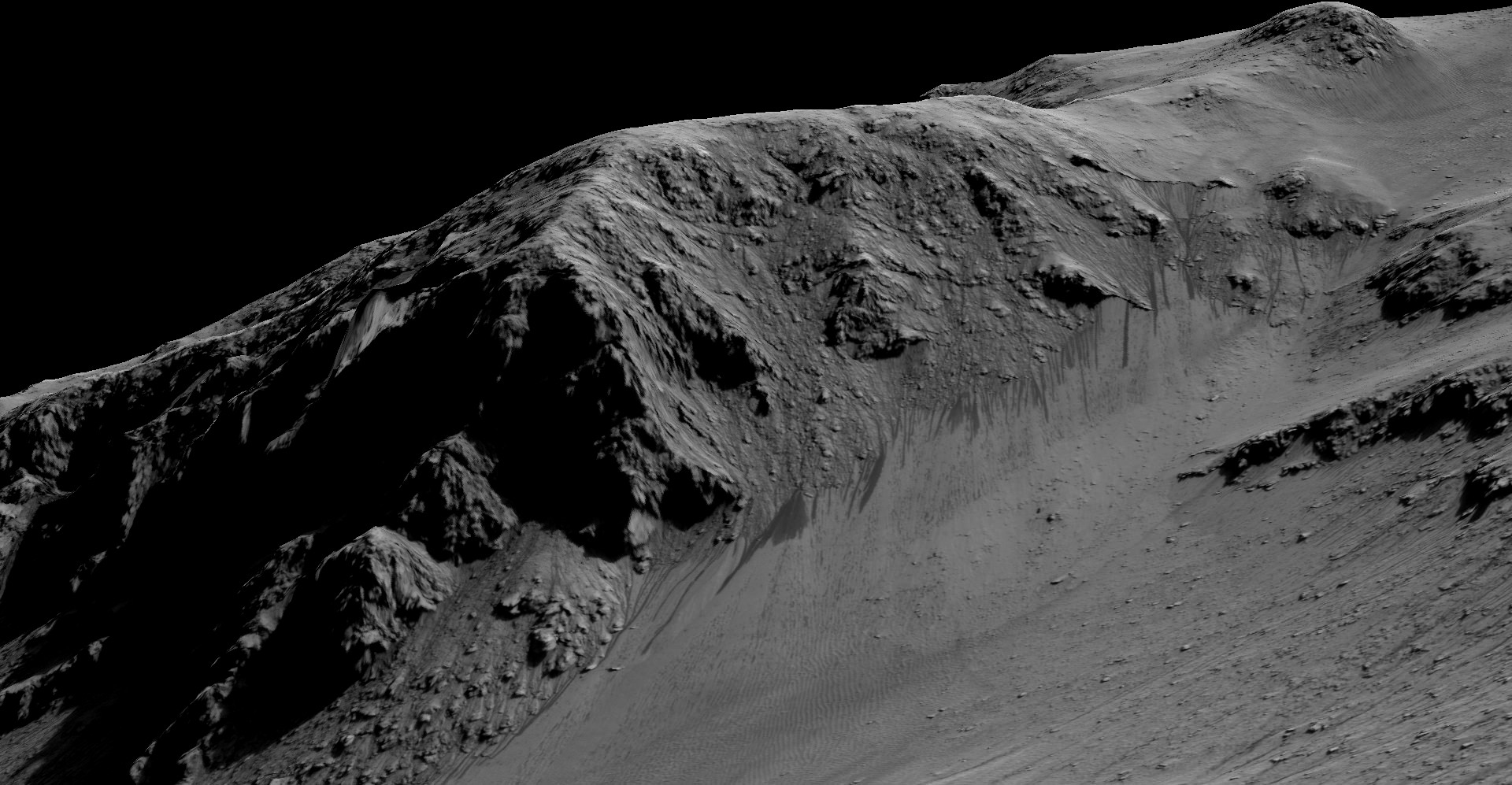
The dark, narrow streaks flowing downhill on Mars at sites such as this portion of Horowitz Crater are inferred to be formed by seasonal flow of water on modern-day Mars. The streaks are roughly the length of a football field. These dark features on the slopes are called "recurring slope lineae" or RSL. The imaging and topographical information in this processed view come from the High Resolution Imaging Science Experiment (HiRISE) camera on NASA's Mars Reconnaissance Orbiter.   Credit: NASA/JPL-Caltech/Univ. of Arizona
The dark, narrow streaks flowing downhill on Mars at sites such as this portion of Horowitz Crater are inferred to be formed by seasonal flow of water on modern-day Mars. The streaks are roughly the length of a football field. These dark features on the slopes are called “recurring slope lineae” or RSL. The imaging and topographical information in this processed view come from the High Resolution Imaging Science Experiment (HiRISE) camera on NASA’s Mars Reconnaissance Orbiter. Credit: NASA/JPL-Caltech/Univ. of Arizona

Along with the media announcement, the researchers published their findings today in a refereed scientific paper in the Sept. 28 issue of Nature Geoscience.

“We found the hydrated salts only when the seasonal features were widest, which suggests that either the dark streaks themselves or a process that forms them is the source of the hydration. In either case, the detection of hydrated salts on these slopes means that water plays a vital role in the formation of these streaks,” said Lujendra Ojha, now at the Georgia Institute of Technology (Georgia Tech) in Atlanta, and lead author of the Sept. 28 publication in Nature Geoscience.

The scientists “interpret the spectral signatures as caused by hydrated minerals called perchlorates.”

Ojha said the chemical signatures from CRISM were most consistent with the detection of mixtures of magnesium perchlorate, magnesium chlorate and sodium perchlorate, based on lab experiments.

“Some perchlorates have been shown to keep liquids from freezing even when conditions are as cold as minus 94 degrees Fahrenheit (minus 70 Celsius).”

Perchlorates have previously been detected in Martian soil by two of NASA’s surface missions – the Phoenix lander and the Curiosity rover. There is also some evidence that NASA’s Viking missions in the 1970s measured signatures of these salts.

On Earth concentration of perchlorates are found in deserts.

This also marks the first time perchlorates have been identified from Mars orbit.
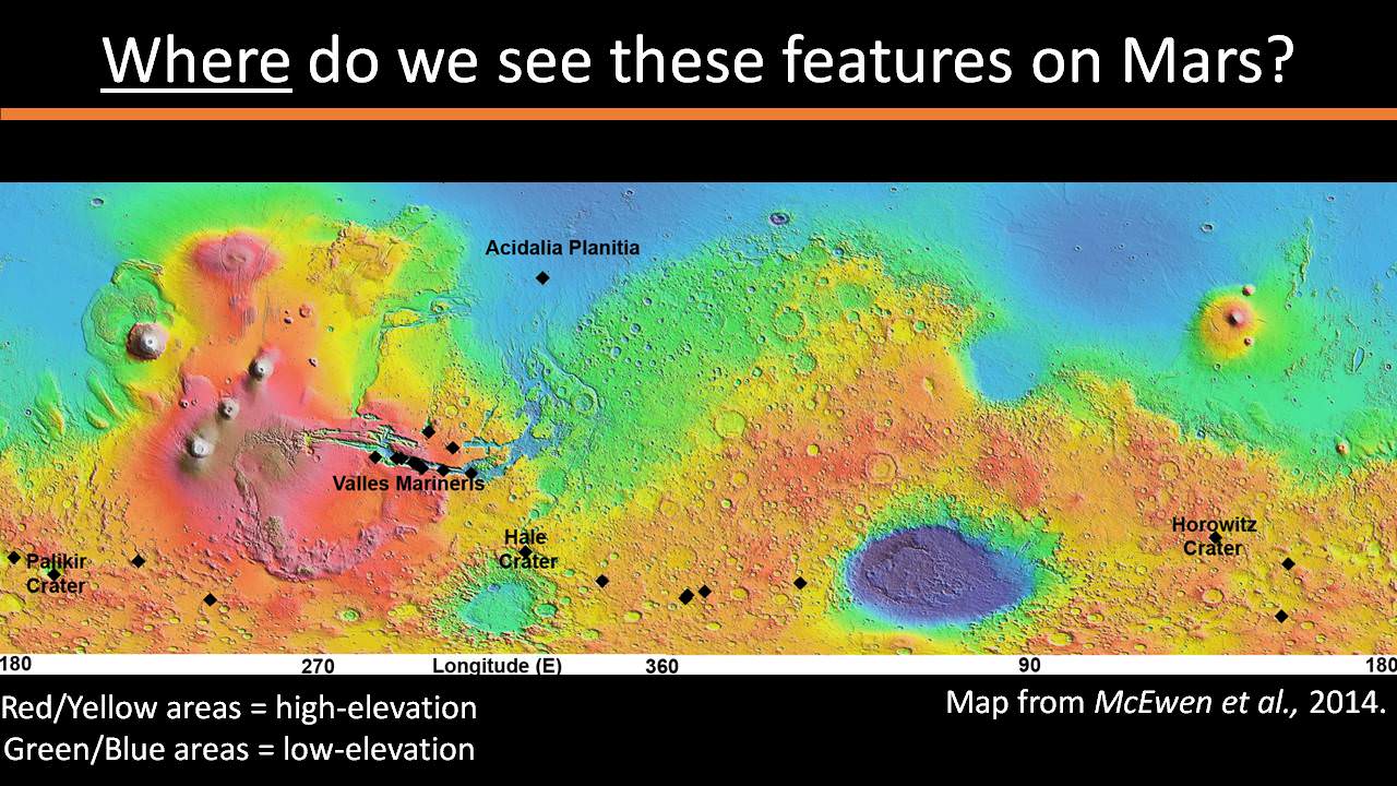
Locations of RSL features on Mars

NASA’s overriding agency wide goal is to send humans on a ‘Journey to Mars’ in the 2030s.

So NASA astronaut Mark Kelly exclaimed that he was also super excited about the findings, from his perch serving as Commander aboard the International Space Station (ISS), where he is a member of the first ever “1 Year ISS Mission Crew” aimed at learning how the human body will adapt to the long term missions required to send astronauts to Mars and back.

“One reason why NASA’s discovery of liquid water on #Mars is so exciting: we know anywhere there’s water on Earth, there’s some form of life,” Kelly tweeted today from on board the ISS, upon hearing today’s news.

The discovery of liquid water on Mars could also be a boon to future astronauts who could use it as a natural resource to ‘live off the land’ for sustenance and to make rocket fuel.

“If going to Mars on my Year In Space, I’d arrive soon to find water! H20 > rocket fuel, which means I could find my way back home too!,” Kelly wrote on his Facebook page.

“When most people talk about water on Mars, they’re usually talking about ancient water or frozen water,” Ojha explained.

“Now we know there’s more to the story. This is the first spectral detection that unambiguously supports our liquid water-formation hypotheses for RSL.”

Stay tuned here for Ken’s continuing Earth and planetary science and human spaceflight news.

Ken Kremer

Matt Damon of ‘The Martian’ Explains NASA’s Journey to Mars – ISS Crew Previews Film on Orbit

Watched @MartianMovie on @Space_Station last night! Today working towards our #JourneyToMars during my #YearInSpace!” Credit: NASA/Scott Kelly

Video caption: ‘The Martian’ Star Matt Damon Discusses NASA’s Journey to Mars. Credit: NASA

The excitement is building for the worldwide movie premiere of ‘The Martian’ on Oct. 2.

Based on the bestselling book by Andy Weir, ‘The Martian’ tells the story of how NASA astronaut Mark Watney, played by Matt Damon, is accidentally stranded on the surface of Mars during a future manned expedition, after a sudden and unexpectedly fierce dust storm forces the rest of the crew to quickly evacuate after they believe he is dead.

In the video above, Matt Damon discusses NASA’s ongoing real life efforts focused on turning science fiction dreams into reality and sending astronauts to Mars.

Watney actually survived the storm but lost contact with NASA. The film recounts his ingenious years long struggle to survive, figure out how to tell NASA he is alive and send a rescue crew before he starves to death on a planet where nothing grows. Watney’s predicament is a survival lesson to all including NASA.

‘The Martian’ was written by Andy Weir in 2010 and has now been produced as a major Hollywood motion picture starring world famous actor Matt Damon and directed by the world famous director Ridley Scott from 20th Century Fox.

NASA’s overriding strategic goal is to send humans on a ‘Journey to Mars’ by the 2030s.

‘The Martian’ is a rather realistic portrayal of how NASA might accomplish the ‘Journey to Mars.’

“Sending people to Mars and returning them safely is the challenge of a generation,” says Damon in the video.

“The boot prints of astronauts will follow the rover tracks [of NASA’s Curiosity rover] thanks to innovations happening today.”

“NASA’s Journey to Mars begins on the International Space Station (ISS) .. where we are learning how humans can thrive over long periods without gravity.”

The current six person crew serving aboard the ISS even got a sneak preview of The Martian this past weekend!

Gleeful NASA astronaut Scott Kelly, commander of the Expedition 45 crew, just tweeted a photo of the crew watching ‘The Martian’ while soaring some 250 miles (400 kilometers) above Earth.

“Watched @MartianMovie on @Space_Station last night! Today working towards our #JourneyToMars during my #YearInSpace!” tweeted NASA astronaut Scott Kelly.

Kelly comprises one half of the first ever ‘1 Year ISS Crew’ along with Russian cosmonaut Mikhail Kornienko, aimed at determining the long term physical and psychological effects on the human body of people living and working in the weightlessness of space.

The 1 Year ISS mission is an important data gathering milestone on the human road to Mars since the round trip time to the Red Planet and back will take approximately 3 years or more.

In order to send astronauts to the Red Planet, NASA is now developing the mammoth Space Launch System (SLS) heavy lift booster and the Orion crew capsule to propel astronauts farther than ever before on the Journey to Mars.

The first unmanned test flight of SLS/Orion is slated for Nov. 2018. The first manned flight could occur between 2021 and 2023 – read my new report here.

“The Journey to Mars will forever change our history books … and expand our human presence deeper into the solar system,” says Damon.

THE MARTIAN features a star studded cast that includes Matt Damon, Jessica Chastain, Kristen Wiig, Kate Mara, Michael Pena, Jeff Daniels, Chiwetel Ejiofor, and Donald Glover.

Matt Damon stars as NASA astronaut Mark Watney in ‘The Martian.' Credit: 20th Century Fox
Matt Damon stars as NASA astronaut Mark Watney in ‘The Martian.’ Credit: 20th Century Fox

“NASA has endorsed “The Martian’” Jim Green, NASA’s Director of Planetary Sciences, told Universe Today. Green served as technical consultant on the film.

I have read the book (I’m a professional chemist) and highly recommend it to everyone.

The Martian is all about how Watney uses his botany and chemistry skills to “Science the Sh.. out of it” to grow food and survive.

Learning how to live of the land will be a key hurdle towards enabling long term space voyages.

Kelly and his ISS cremates took a big first step towards putting that theory into practice when they recently grew, harvested and ate the first space grown NASA lettuce on the ISS using the Veggie experimental rack – detailed in my recent story here.

NASA Astronauts Kjell Lindgren (center) and Scott Kelly (right) and Kimiya Yui (left) of Japan consume space grown food for the first time ever, from the aboard the  from the Veggie plant growth system on the International Space Station.  Credit: NASA TV
NASA Astronauts Kjell Lindgren (center) and Scott Kelly (right) and Kimiya Yui (left) of Japan consume space grown food for the first time ever, from the Veggie plant growth system on the International Space Station. Credit: NASA TV

Here’s the second official trailer of “The Martian:

Stay tuned here for Ken’s continuing Earth and planetary science and human spaceflight news.
Ken Kremer

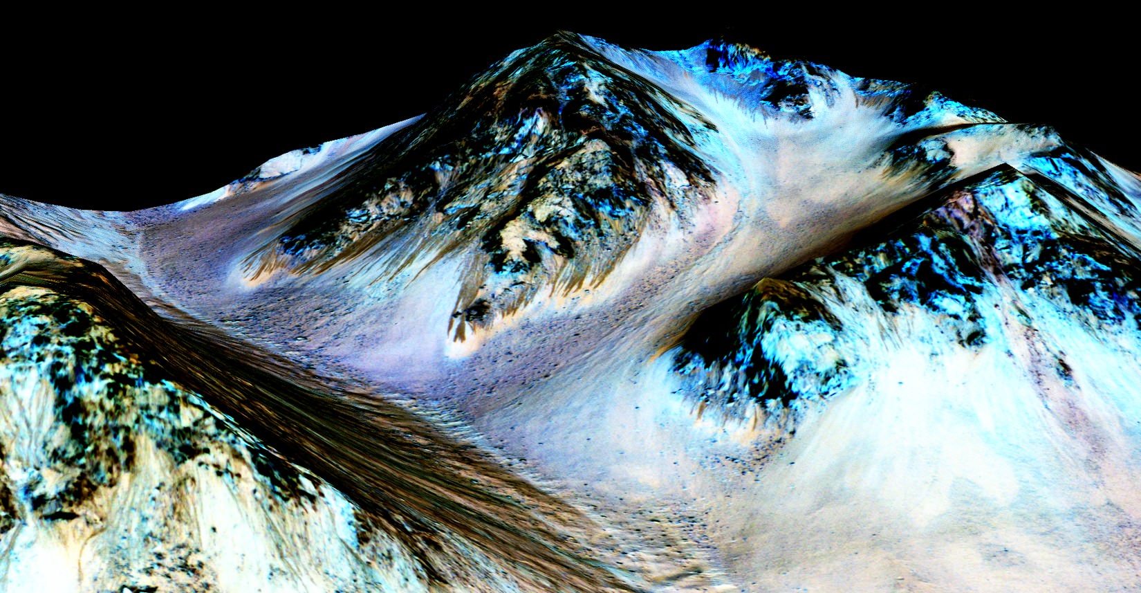
Veggie demonstration apparatus growing red romaine lettuce under LED lights in the Space Station Processing Facility at NASA’s Kennedy Space Center.  Credit: Ken Kremer/kenkremer.com
Veggie demonstration apparatus growing red romaine lettuce under LED lights in the Space Station Processing Facility at NASA’s Kennedy Space Center. Credit: Ken Kremer/kenkremer.com

Curiosity Investigates Petrified Martian Sand Dunes, Contemplates Next Drill Campaign

Large-scale crossbedding in the sandstone of this ridge on a lower slope of Mars' Mount Sharp is typical of windblown sand dunes that have petrified. NASA's Curiosity Mars rover used its Mastcam to capture this vista on Aug. 27, 2015, Sol 1087. Similarly textured sandstone is common in the U.S. Southwest. Credits: NASA/JPL-Caltech/MSSS

Large-scale crossbedding in the sandstone of this ridge on a lower slope of Mars’ Mount Sharp is typical of windblown sand dunes that have petrified. NASA’s Curiosity Mars rover used its Mastcam to capture this vista on Aug. 27, 2015, Sol 1087. Similarly textured sandstone is common in the U.S. Southwest. Credits: NASA/JPL-Caltech/MSSS
See Sol 1100 mosaic below [/caption]

NASA’s SUV-sized Curiosity rover has arrived at a beautiful Martian vista displaying a huge deposit of magnificently petrified sand dunes that look remarkably like some commonly found on Earth and native to the deserts of the U.S. Southwest.

The dunes are keenly fascinating to Red Planet researchers as the NASA robot celebrates 1100 fabulous Sols of exploration and discovery on Mars and contemplates plans for the next drill campaign later this month. See dune mosaic above and our Sol 1100 mosaic below.

The petrified sand dunes were discovered amongst an area of dark sandstone along a ridge at the lower slope of Mars’ Mount Sharp. They are now being explored in detail by the six wheeled rover in a geologic feature dubbed the Stimson unit.

“The team is considering where to drill next within the Stimson sandstone and we are looking for the best light toned areas to check for mineralogical signs of water-rock reaction,” says John Bridges, rover team member from the University of Leicester, England, in the latest mission update from today, September 12, 2015.

Curiosity looks toward fabulous canyons and buttes at the base of Mount Sharp from the Stimson sand dunes on Mars on Sol 1100, Sept. 10  2015 in this photo mosaic stitched from Mastcam color camera raw images.  Credit: NASA/JPL/MSSS/Ken Kremer/kenkremer.com/Marco Di Lorenzo
Curiosity looks toward fabulous canyons and buttes at the base of Mount Sharp from the Stimson sand dunes on Mars on Sol 1100, Sept. 10 2015 in this photo mosaic stitched from Mastcam color camera raw images. Credit: NASA/JPL/MSSS/Ken Kremer/kenkremer.com/Marco Di Lorenzo

Curiosity also discovered large-scale crossbedding in the sandstone that were formed by the action of Martian winds.

“This sandstone outcrop — part of a geological layer that Curiosity’s science team calls the Stimson unit — has a structure called crossbedding on a large scale that the team has interpreted as deposits of sand dunes formed by wind,” according to the rover team.

So Curiosity was commanded by her handlers back on Earth to capture an array of high resolution imagery as part of detailed investigation of the area for up close and contact science.

Dozens of images were taken with the pair of high resolution Mastcam color cameras on the robots mast and combined into the panoramic scene show above and another shown below with a scalebar the length of a tall human, 6.6 feet or 200 centimeters.

Large-scale crossbedding in the sandstone of this ridge on a lower slope of Mars' Mount Sharp is typical of windblown sand dunes that have petrified. NASA's Curiosity Mars rover used its Mastcam to capture this vista on Aug. 27, 2015. Similarly textured sandstone is common in the U.S. Southwest.  Credits: NASA/JPL-Caltech/MSSS
Large-scale crossbedding in the sandstone of this ridge on a lower slope of Mars’ Mount Sharp is typical of windblown sand dunes that have petrified. NASA’s Curiosity Mars rover used its Mastcam to capture this vista on Aug. 27, 2015. Similarly textured sandstone is common in the U.S. Southwest. Credits: NASA/JPL-Caltech/MSSS

The images were taken on Aug. 27, 2015, corresponding to Sol 1087 of the rover’s work on Mars, using both the 34 millimeter-focal-length lens and the 100 mm millimeter-focal-length telephoto Mastcam camera lenses that function as Curiosity’s left and right eyes.

The panorama spans the Martian terrain looking from the east, at left, to the south-southwest at right.

“Some of the dark sandstone in the area …. shows texture and inclined bedding structures characteristic of deposits that formed as sand dunes, then were cemented into rock” say officials.

“Sets of bedding laminations lie at angles to each other.”

Since taking the panorama in late August, the team has driven Curiosity around the area to collect more measurements with her state of the art science instruments.

Later this month, Curiosity will drill into an outcrop at the Stimson unit sandstone for collection and feed it for analysis into the pair of on board chemistry labs – SAM and CheMin- located inside the rover’s belly.

Curiosity already carried out initial contact science in the area by extending the robotic arm to rock targets for investigation with the arm mounted instruments, including the MAHLI camera and APXS spectrometer.

Curiosity “investigated an outcrop of the Stimson unit … and conducted successful contact science,” says Lauren Edgar, Research Geologist at the USGS Astrogeology Science Center and an MSL science team member, in a mission update.

Scientists will select the Stimson drill target soon.

Curiosity rover explores around the Stimson unit at the base of Mount Sharp on Mars on Sol 1095, Sept. 5, 2015 in this photo mosaic stitched from Mastcam color camera raw images.  Credit: NASA/JPL/MSSS/Marco Di Lorenzo/Ken Kremer/kenkremer.com
Curiosity rover explores around the Stimson unit at the base of Mount Sharp on Mars on Sol 1095, Sept. 5, 2015 in this photo mosaic stitched from Mastcam color camera raw images. Credit: NASA/JPL/MSSS/Marco Di Lorenzo/Ken Kremer/kenkremer.com

Why explore outcrops at Stimson?

“The Stimson unit overlies a layer of mudstone that was deposited in a lake environment. Curiosity has been examining successively higher and younger layers of Mount Sharp, starting with the mudstone at the mountain’s base, for evidence about changes in the area’s ancient environment.”

Curiosity’s prior drill campaign was recently conducted at the “Buckskin” outcrop target in early August 2015. Buckskin was very notable for being the first high silica rock drilling target of the mission.

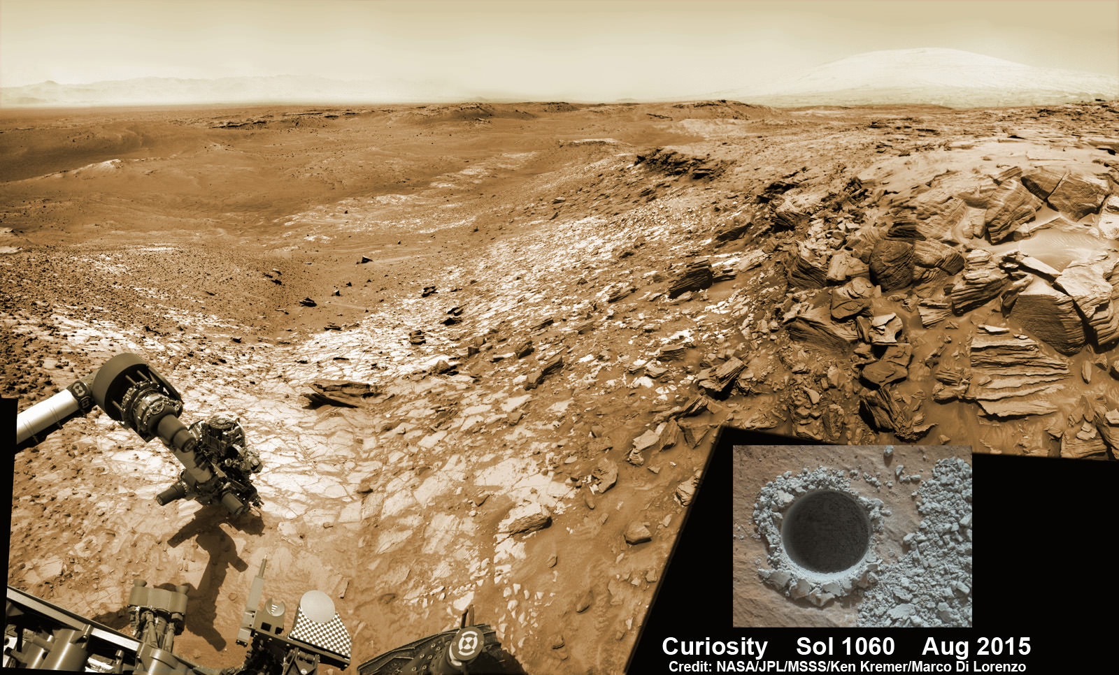
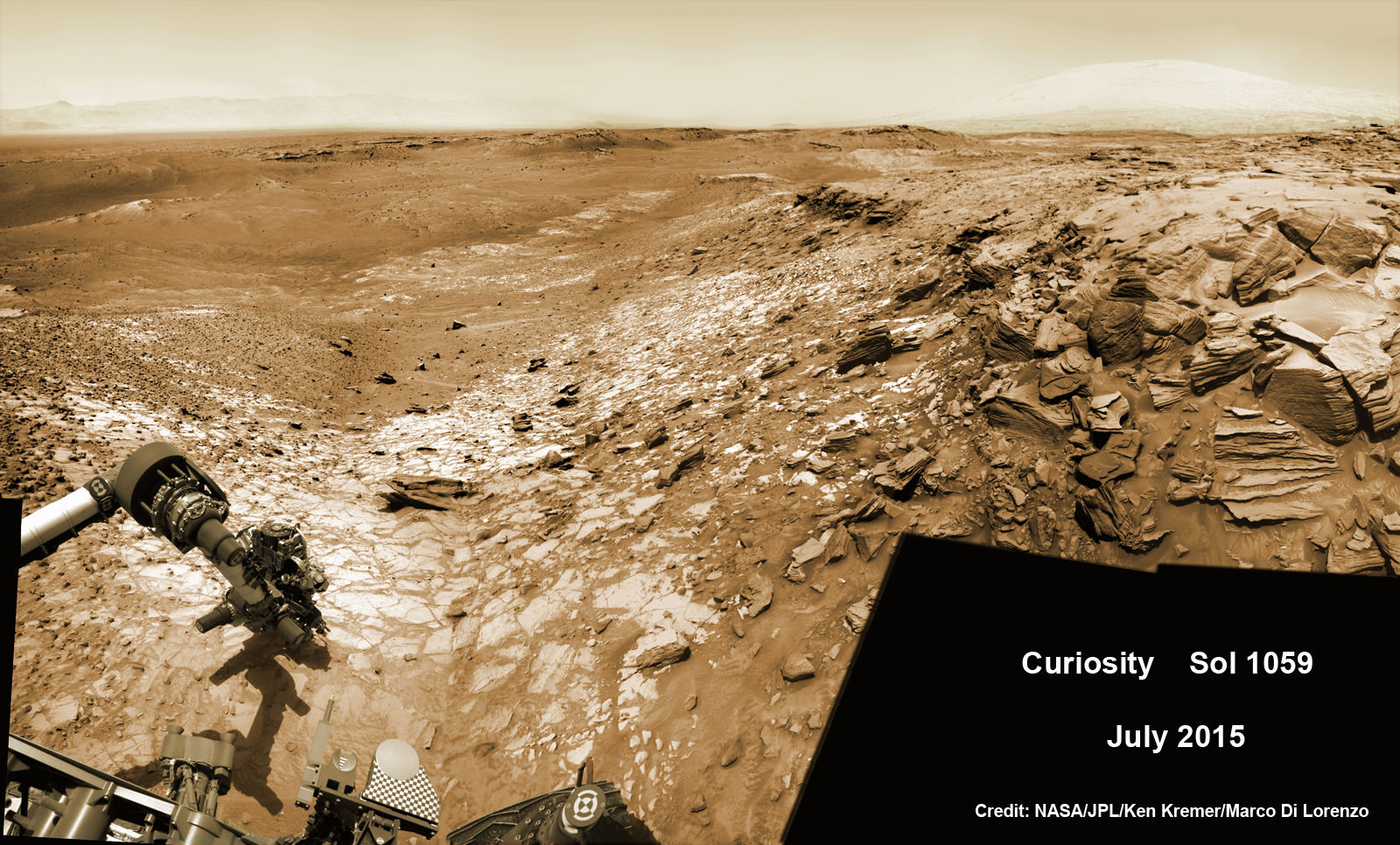
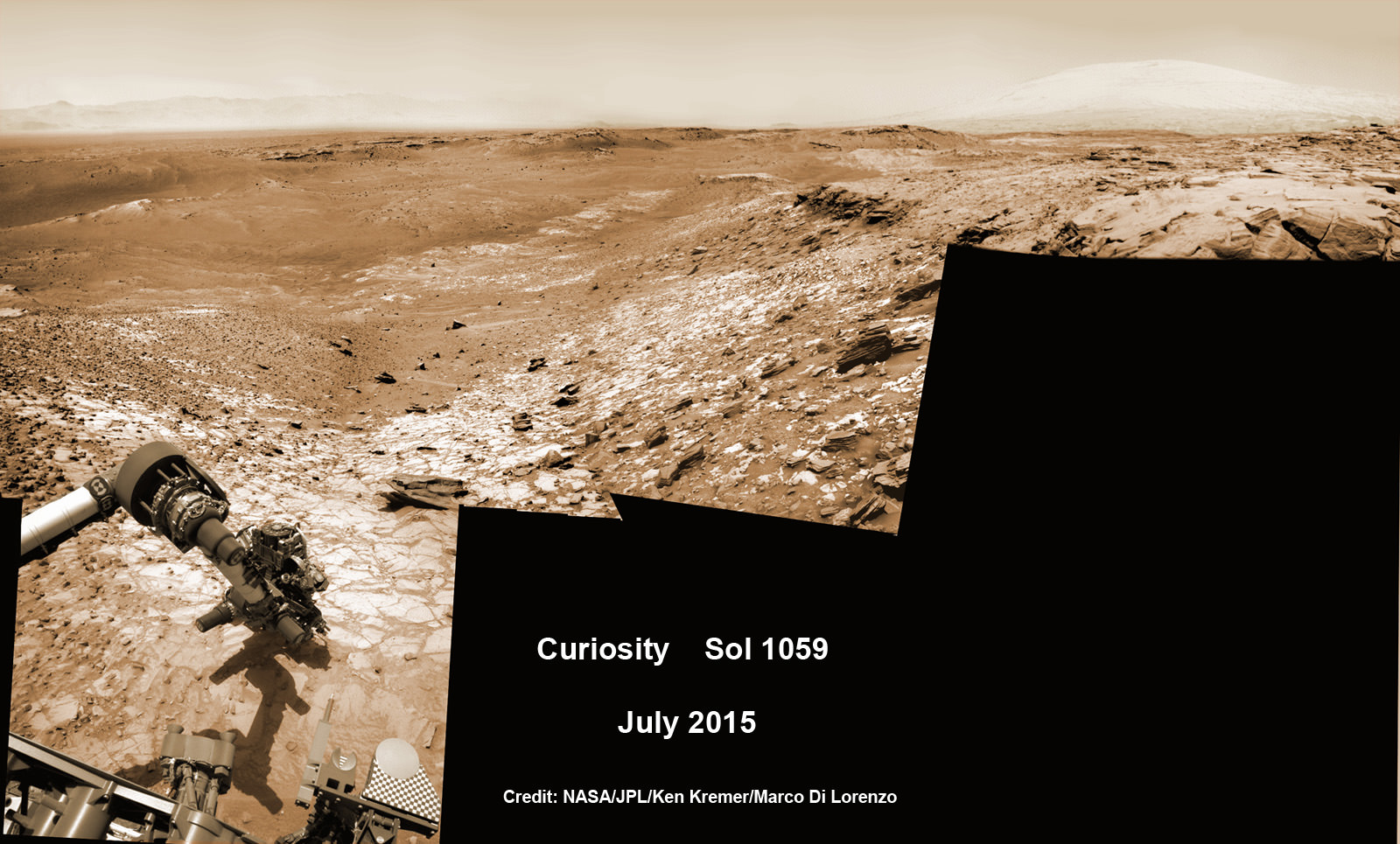
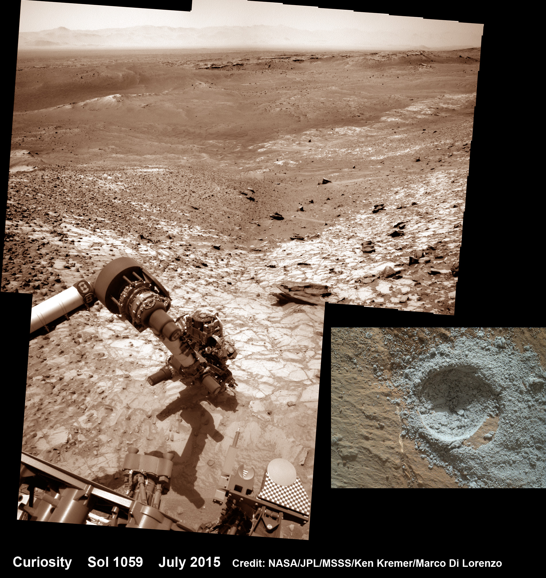
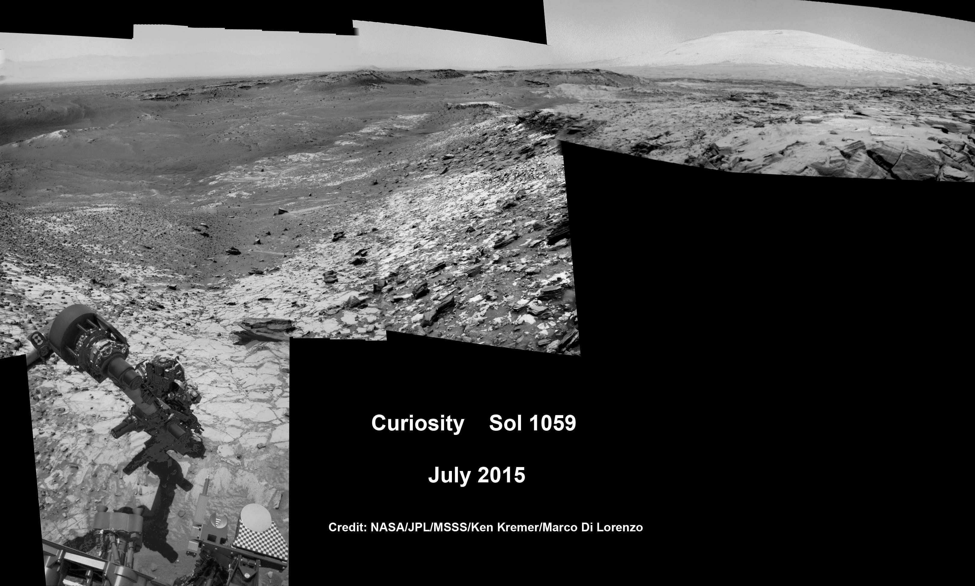
Curiosity extends robotic arm and conducts sample drilling at “Buckskin” rock target at bright toned “Lion” outcrop at the base of Mount Sharp on Mars, seen at right.   Gale Crater eroded rim seen in the distant background at left, in this composite multisol mosaic of navcam raw images taken to Sol 1059, July 30, 2015.  Navcam camera raw images stitched and colorized. Inset: MAHLI color camera up close image of full depth drill hole at “Buckskin” rock target on Sol 1060.  Credit:  NASA/JPL-Caltech/MSSS/Ken Kremer/kenkremer.com/Marco Di Lorenzo
Curiosity extends robotic arm and conducts sample drilling at “Buckskin” rock target at bright toned “Lion” outcrop at the base of Mount Sharp on Mars, seen at right. Gale Crater eroded rim seen in the distant background at left, in this composite multisol mosaic of navcam raw images taken to Sol 1059, July 30, 2015. Navcam camera raw images stitched and colorized. Inset: MAHLI color camera up close image of full depth drill hole at “Buckskin” rock target on Sol 1060. Credit: NASA/JPL-Caltech/MSSS/Ken Kremer/kenkremer.com/Marco Di Lorenzo

Stimson and Buckskin sit at the base of Mount Sharp, a huge layered mountain that dominates the center of the 96 mile-wide (154 kilometers-wide) Gale Crater landing site.

Exploring the sedimentary layers of Mount Sharp, which towers 3.4 miles (5.5 kilometers) into the Martian sky, is the primary destination and goal of the rovers long term scientific expedition on the Red Planet.

Curiosity recently celebrated 1000 Sols of exploration on Mars on May 31, 2015 – detailed here with our Sol 1000 mosaic by Marco Di Lorenzo and Ken Kremer also featured at Astronomy Picture of the Day on June 13, 2015.

As of today, Sol 1102, September 12, 2015, she has driven some 6.9 miles (11.1 kilometers) kilometers and taken over 268,000 amazing images.

Curiosity has already accomplished her primary objective of discovering a habitable zone on the Red Planet – at the Yellowknife Bay area – that contains the minerals necessary to support microbial life in the ancient past when Mars was far wetter and warmer billions of years ago.

Curiosity rover scans toward south east around Marias Pass area at the base of Mount Sharp on Mars on Sol 1074, Aug. 14, 2015 in this photo mosaic stitched from Mastcam color camera raw images.  Credit: NASA/JPL/MSSS/Marco Di Lorenzo/Ken Kremer/kenkremer.com
Curiosity rover scans toward south east around Marias Pass area at the base of Mount Sharp on Mars on Sol 1074, Aug. 14, 2015 in this photo mosaic stitched from Mastcam color camera raw images. Credit: NASA/JPL/MSSS/Marco Di Lorenzo/Ken Kremer/kenkremer.com

Stay tuned here for Ken’s continuing Earth and planetary science and human spaceflight news.

Ken Kremer

What Do Other Planets Sound Like?

What Do Other Planets Sound Like?

We know that in space, no one can hear you scream. But what would things sound like on another planet?

When humans finally set foot on Mars, they’re going to be curious about everything around them.

What’s under that rock? What does it feel like to jump in the lower Martian gravity. What does Martian regolith taste like? What’s the bitcoin to red rock exchange rate?

As long as they perform their activities in the safety of a pressurized habitation module or exosuit, everything should be fine. But what does Mars sound like?

I urge all future Martian travelers, no matter how badly you want to know the answer to this question: don’t take your helmet off. With only 1% the atmospheric pressure of Earth, you’d empty your lungs with a final scream in a brief and foolish moment, then suffocate horribly with a mouthful of dust on the surface of the Red Planet.

But… actually, even the screaming would sound a little different. How different? Let me show you. First you just need to take your helmet off for a just a little sec, just an itsy bitsy second. Here, I’ll hold it for you. Oh, come on, just take your helmet off. All the cool kids are doing it.

What about Venus? Or Titan? What would everything sound like on an alien world?

We evolved to exist on Earth, and so it’s perfectly safe for us to listen to sounds in the air. No space suit needed. Unless you didn’t evolve on Earth, in which case I offer to serve as emissary to our all new alien overlords.

You know sounds travel when waves of energy propagate through a medium, like air or water. The molecules bump into each other and pass along the energy until they strike something that won’t move, like your ear drum. Then your brain turns bouncing into sounds.

The speed of the waves depends on what the medium is made of and how dense it is. For example, sound travels at about 340 meters/second in dry air, at sea level at room temperature. Sound moves much more quickly through liquid. In water it’s nearly 1,500 m/s. It’s even faster through a solid – iron is up past 5,100 m/s. Our brain perceives a different sound depending on the intensity of the waves and how quickly they bounce off our ears.

Artist's impression of the surface of Venus. Credit: ESA/AOES
Artist’s impression of the surface of Venus. Credit: ESA/AOES

Other worlds have media that sound waves can travel through, and with your eardrum exposed to the atmosphere you should theoretically hear sounds on other worlds. Catastrophic biological failures from using your eardrums outside of documented pressure tolerances notwithstanding.

Professor Tim Leighton and a team of researchers from the University of Southampton have simulated what we would hear standing on the surface of other worlds, like Mars, Venus or even Saturn’s Moon Titan.

On Venus, the pitch of your voice would become deeper, because vocal cords would vibrate much more slowly in the thicker Venusian atmosphere. But sounds would travel more quickly through the soupy atmosphere. According to Dr. Leighton, humans would sound like bass Smurfs. Mars would sound a little bit higher, and Titan would sound totally alien.

Dr. Leighton actually simulated the same sound on different worlds. Here’s the sound of thunder on Earth.
Here’s what it would sound like on Venus.
And here’s what it would sound like on Mars.
Here’s what a probe splashing into water on Earth would sound like.
And here’s what it would sound like splashing into a hydrocarbon lake on Titan.

You might be amazed to learn that we still haven’t actually recorded sounds on another world, right up until someone points out that putting a microphone on another planet hasn’t been that big a priority for any space mission.

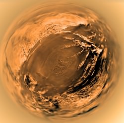
A fish-eye view of Titan's surface from the European Space Agency's Huygens lander in January 2005. Credit: ESA/NASA/JPL/University of Arizona
A fish-eye view of Titan’s surface from the European Space Agency’s Huygens lander in January 2005. Credit: ESA/NASA/JPL/University of Arizona

Especially when we could analyze soil samples, but hey fart sounds played and then recorded in the Venusian atmosphere could prove incredibly valuable to the future of internet soundboards.

The Planetary Society has been working to get a microphone included on a mission. They actually included a microphone on the Mars Polar Lander mission that failed in 1999. Another French mission was going to have a microphone, but it was cancelled. There are no microphones on either Spirit or Opportunity, and the Curiosity Rover doesn’t have one either despite its totally bumping stereo.

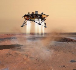
Here’s is the only thing we’ve got. When NASA’s Phoenix Lander reached the Red Planet in 2008, it had a microphone on board to capture sounds. It recorded audio as it entered the atmosphere, but operators turned the instrument off before it reached the surface because they were worried it would interfere with the landing.

Mars Phoenix Lander. Image credit: NASA/JPL/SSI

Here’s the recording.

Meh. I’m going to need you to do better NASA. I want an actual microphone recording winds on the surface of Mars. I hope it’s something Dethklok puts on their next album, they could afford that kind of expense.

It turns out, that if you travel to an alien world, not only would the sights be different, but the sounds would be alien too. Of course, you’d never know because you’re be too chicken to take your helmet off and take in the sounds through the superheated carbon dioxide or methane atmosphere.

What sounds would you like to hear on an alien world? Tell us in the comments below.

Curiosity Snaps Stunning One of a Kind Belly Selfie At Buckskin Mountain Base Drill Site

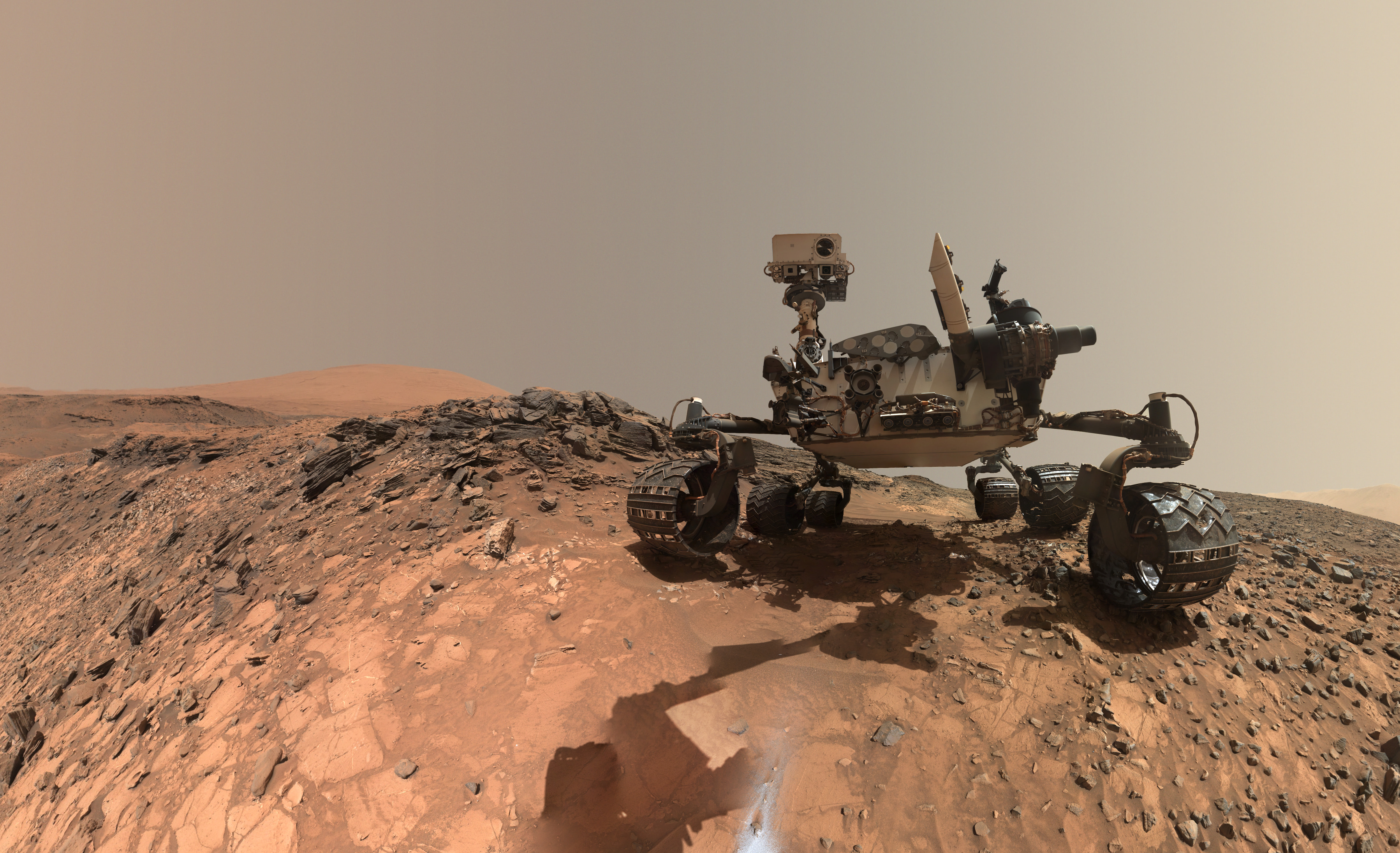
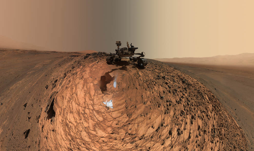
This low-angle self-portrait of NASA's Curiosity Mars rover shows the vehicle at the site from which it reached down to drill into a rock target called "Buckskin." The MAHLI camera on Curiosity's robotic arm took multiple images on Aug. 5, 2015, that were stitched together into this selfie. Credits: NASA/JPL-Caltech/MSSS

This low-angle self-portrait of NASA’s Curiosity Mars rover shows the vehicle at the site from which it reached down to drill into a rock target called “Buckskin.” The MAHLI camera on Curiosity’s robotic arm took multiple images on Aug. 5, 2015, that were stitched together into this selfie. Credits: NASA/JPL-Caltech/MSSS
More selfie and drilling mosaics below[/caption]

NASA’s Curiosity rover has snapped a stunningly beautiful, one of a kind ‘belly selfie’ amidst the painstaking ‘Buckskin’ drill campaign at the Martian mountain base marking the third anniversary since her touchdown on the Red Planet.

The unique self portrait was taken from a low-angle for the first time and shows the six wheeled rover at work collecting her seventh drilled sample at the ‘Buckskin’ rock target earlier this month in the “Marias Pass” area of lower Mount Sharp.

‘Buckskin’ is also unique in a fabulously scientifically way because the rover discovered a new type of Martian rock that’s surprisingly rich in silica – and unlike any other targets found before.

The low camera angle is what enables the awesome Buckskin belly selfie. It’s a distinctively dramatic view and actually stitched from 92 images captured by the Mars Hand Lens Imager (MAHLI) on Aug. 5, 2015, or Sol 1065 of the mission.

The high resolution MAHLI color camera is located on the end of the 7 foot-long (2.1 meter-long) robotic arm.

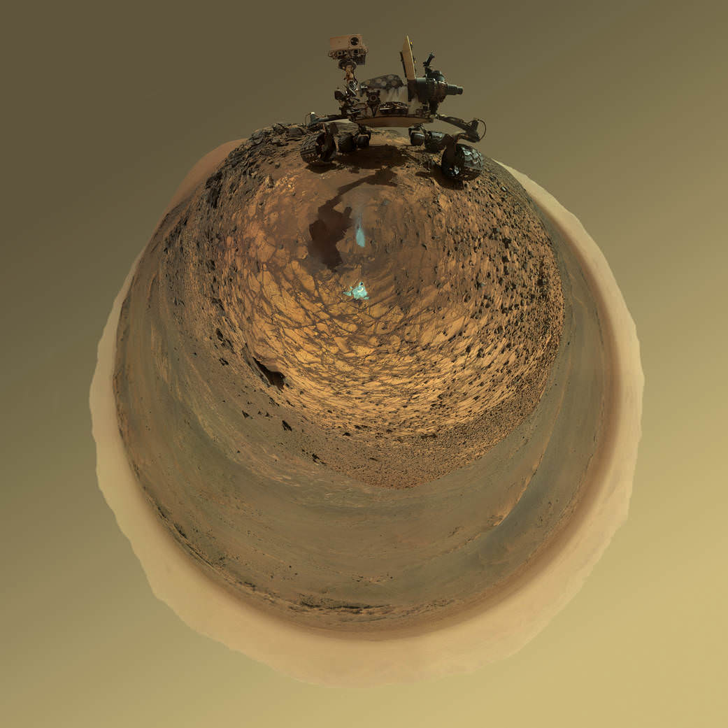
This version of a self-portrait of NASA's Curiosity Mars rover at a drilling site called "Buckskin" is presented as a stereographic projection, which shows the horizon as a circle. The MAHLI camera on Curiosity's robotic arm took dozens of component images for this selfie on Aug. 5, 2015.  Credits: NASA/JPL-Caltech/MSSS
This version of a self-portrait of NASA’s Curiosity Mars rover at a drilling site called “Buckskin” is presented as a stereographic projection, which shows the horizon as a circle. The MAHLI camera on Curiosity’s robotic arm took dozens of component images for this selfie on Aug. 5, 2015. Credits: NASA/JPL-Caltech/MSSS

Indeed the car-sized rover has taken spectacular selfies several times before during her three year long trek across the Martian surface, since the August 2012 landing inside Mars’ Gale Crater. But for those past selfies the MAHLI camera was hoisted higher to give the perspective of looking somewhat downward and showing the rovers top deck and trio of sample inlet ports.

In this case, the rover team specifically commanded Curiosity to position “the camera lower in relation to the rover body than for any previous full self-portrait of Curiosity,” said NASA officials.

Two patches of gray colored powdered rock material drilled from Buckskin are visible in the selfie scene, in front of the rover.

“The patch closer to the rover is where the sample-handling mechanism on Curiosity’s robotic arm dumped collected material that did not pass through a sieve in the mechanism. Sieved sample material was delivered to laboratory instruments inside the rover. The patch farther in front of the rover, roughly triangular in shape, shows where fresh tailings spread downhill from the drilling process.”

Prior selfies were taken at the “Rocknest” (http://photojournal.jpl.nasa.gov/catalog/PIA16468), “John Klein” (http://photojournal.jpl.nasa.gov/catalog/PIA16937), “Windjana” (http://photojournal.jpl.nasa.gov/catalog/PIA18390) and “Mojave” drill sites.

Basically in the Sol 1065 belly selfie at “Buckskin” we see the underbelly of the rover and all six wheels along with a complete self portrait.

This version of a self-portrait of NASA's Curiosity Mars rover at a drilling site called "Buckskin" is presented as a stereographic projection, which shows the horizon as a circle. The MAHLI camera on Curiosity's robotic arm took dozens of component images for this selfie on Aug. 5, 2015.  Credits: NASA/JPL-Caltech/MSSS
This version of a self-portrait of NASA’s Curiosity Mars rover at a drilling site called “Buckskin” is presented as a stereographic projection, which shows the horizon as a circle. The MAHLI camera on Curiosity’s robotic arm took dozens of component images for this selfie on Aug. 5, 2015. Credits: NASA/JPL-Caltech/MSSS

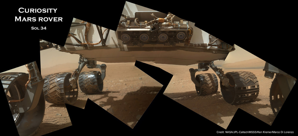
On several prior occasions, MAHLI was used to image just the underbelly and wheels to aid in inspecting the wheels to look for signs of damage inflicted by sharp-edged Martian rocks poking holes in the aluminum wheels.

Underbelly view of Curiosity rover and wheels on Sol 34.  Credit: NASA/JPL/MSSS/Ken Kremer/Marco Di Lorenzo
Underbelly view of Curiosity rover and wheels on Sol 34, Sept. 9, 2012. Credit: NASA/JPL/MSSS/Ken Kremer/Marco Di Lorenzo

Each wheel measures 20 inches (50 centimeters) in diameter and about 16 inches (40 centimeters) wide. And the MAHLI monitoring images have shown the effects of increasing wear and tear that ultimately forced the rover drivers to alter Curiosity’s driving route on the crater floor in favor of smoother and less rocky terrain imparting less damage to the critical wheels.

If you take a close look at the new selfie up top, you’ll see a small rock stuck onto Curiosity’s left middle wheel (on the right in this head-on view). The rock was seen also in prior wheel monitoring images taken three weeks ago.

“The selfie at Buckskin does not include the rover’s robotic arm beyond a portion of the upper arm held nearly vertical from the shoulder joint. With the wrist motions and turret rotations used in pointing the camera for the component images, the arm was positioned out of the shot in the frames or portions of frames used in this mosaic,” according to officials.

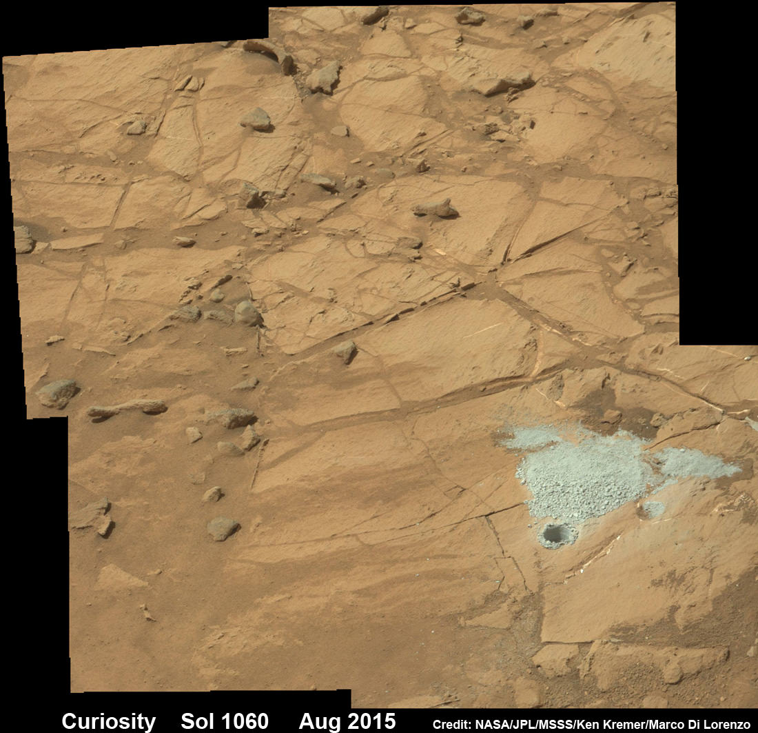
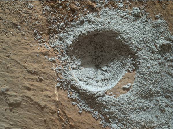
The drilling campaign into “Buckskin” was successfully conducted on Sol 1060 (July 30, 2015) at the bright toned “Lion” outcrop to a full depth of about 2.6 inches (6.5 centimeters) and approximately 1.6 cm (0.63 inch) diameter.

Curiosity extends robotic arm and conducts sample drilling at “Buckskin” rock target at bright toned “Lion” outcrop at the base of Mount Sharp on Mars, seen at right.   Gale Crater eroded rim seen in the distant background at left, in this composite multisol mosaic of navcam raw images taken to Sol 1059, July 30, 2015.  Navcam camera raw images stitched and colorized. Inset: MAHLI color camera up close image of full depth drill hole at “Buckskin” rock target on Sol 1060.  Credit:  NASA/JPL-Caltech/MSSS/Ken Kremer/kenkremer.com/Marco Di Lorenzo
Curiosity extends robotic arm and conducts sample drilling at “Buckskin” rock target at bright toned “Lion” outcrop at the base of Mount Sharp on Mars, seen at right. Gale Crater eroded rim seen in the distant background at left, in this composite multisol mosaic of navcam raw images taken to Sol 1059, July 30, 2015. Navcam camera raw images stitched and colorized. Inset: MAHLI color camera up close image of full depth drill hole at “Buckskin” rock target on Sol 1060. Credit: NASA/JPL-Caltech/MSSS/Ken Kremer/kenkremer.com/Marco Di Lorenzo

You can also see another perspective of the rover at work while reaching out with the robotic arm and drilling into ‘Buckskin’ as illustrated in our mosaics of mastcam and navcam camera raw images created by the image processing team of Ken Kremer and Marco Di Lorenzo.

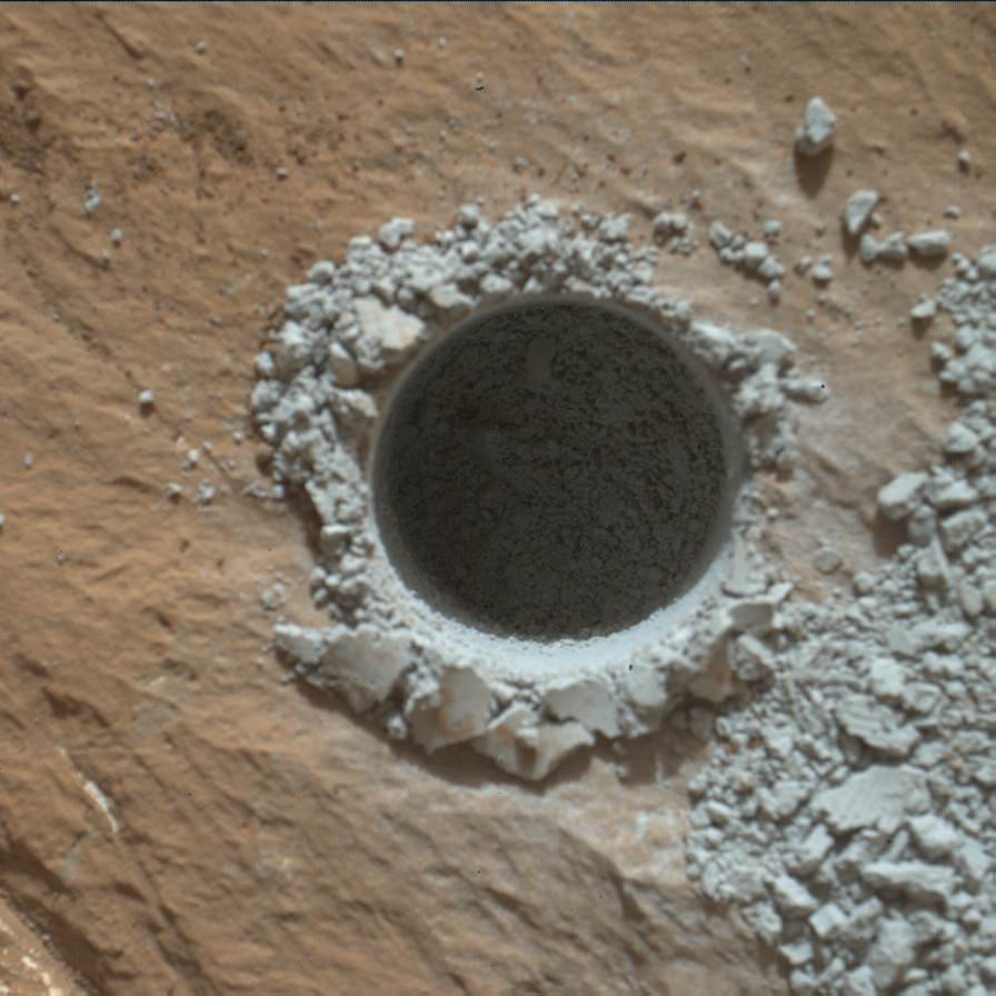
The main bore hole was drilled next to the initial mini hole test and shows the indicative residue of grey colored tailings from the Martian subsurface seen distributed around the new hole.

Curiosity rover successfully drills into Martian outcrop  at Buckskin rock target at current work site at base of Mount Sharp in August 2015, in this mosaic showing full depth drill hole and initial test hole, with grey colored subsurface tailings and mineral veins on surrounding Red Planet terrain.  This high resolution photo mosaic is a multisol composite of color images taken by the mast mounted Mastcam-100 color camera up to Sol 1060, July 31, 2015.   Credit:  NASA/JPL-Caltech/Ken Kremer/kenkremer.com/Marco Di Lorenzo
Curiosity rover successfully drills into Martian outcrop at Buckskin rock target at current work site at base of Mount Sharp in August 2015, in this mosaic showing full depth drill hole and initial test hole, with grey colored subsurface tailings and mineral veins on surrounding Red Planet terrain. This high resolution photo mosaic is a multisol composite of color images taken by the mast mounted Mastcam-100 color camera up to Sol 1060, July 31, 2015. Credit: NASA/JPL-Caltech/Ken Kremer/kenkremer.com/Marco Di Lorenzo

Curiosity has now moved on from the “Marias Pass” area.

Curiosity recently celebrated 1000 Sols of exploration on Mars on May 31, 2015 – detailed here with our Sol 1000 mosaic also featured at Astronomy Picture of the Day on June 13, 2015.

As of today, Sol 1080, August 20, 2015, she has driven some 6.9 miles (11.1 kilometers) kilometers and taken over 260,000 amazing images.

Curiosity rover scans toward south east around Marias Pass area at the base of Mount Sharp on Mars on Sol 1074, Aug. 14, 2015 in this photo mosaic stitched from Mastcam color camera raw images.  Credit: NASA/JPL/MSSS/Marco Di Lorenzo/Ken Kremer/kenkremer.com
Curiosity rover scans toward south east around Marias Pass area at the base of Mount Sharp on Mars on Sol 1074, Aug. 14, 2015 in this photo mosaic stitched from Mastcam color camera raw images. Credit: NASA/JPL/MSSS/Marco Di Lorenzo/Ken Kremer/kenkremer.com

Curiosity has already accomplished her primary objective of discovering a habitable zone on the Red Planet – at the Yellowknife Bay area – that contains the minerals necessary to support microbial life in the ancient past when Mars was far wetter and warmer billions of years ago.

Stay tuned here for Ken’s continuing Earth and planetary science and human spaceflight news.

Ken Kremer

NASA Invites Public to ‘Send Your Name to Mars’ on InSight – Next Red Planet Lander

Sign up to send your name to Mars on InSight, NASA’s next mission to Mars launching in March 2016. Credit: NASA

Sign up to send your name to Mars on InSight, NASA’s next mission to Mars launching in March 2016. Credit: NASA
Sign up link below – don’t delay![/caption]

Calling space fans worldwide: Now is your chance to participate in NASA’s human ‘Journey to Mars’ initiative and NASA’s next robotic mission to Mars – the InSight lander launching to the Red Planet next spring.

NASA invites you to ‘Send Your Name to Mars’ on a silicon microchip aboard the InSight probe slated for blastoff on March 4, 2016 from Vandenberg Air Force Base, California.

InSight’s science goal is totally unique – to “listen to the heart of Mars to find the beat of rocky planet formation.”

The public can submit their names for inclusion on a dime-sized microchip that will travel on a variety of spacecraft voyaging to destinations beyond low-Earth orbit, including Mars.

“Our next step in the journey to Mars is another fantastic mission to the surface,” said Jim Green, director of planetary science at NASA Headquarters in Washington.

“By participating in this opportunity to send your name aboard InSight to the Red Planet, you’re showing that you’re part of that journey and the future of space exploration.”

In just the first 24 hours over 67,000 Mars enthusiasts have already signed up!

But time is of the essence since the deadline to submit your name is soon: Sept. 8, 2015.

How can you sign up to fly on InSight? Is there a certificate?

NASA has made it easy to sign up.

To send your name to Mars aboard InSight, click on this weblink posted online by NASA:

http://go.usa.gov/3Aj3G

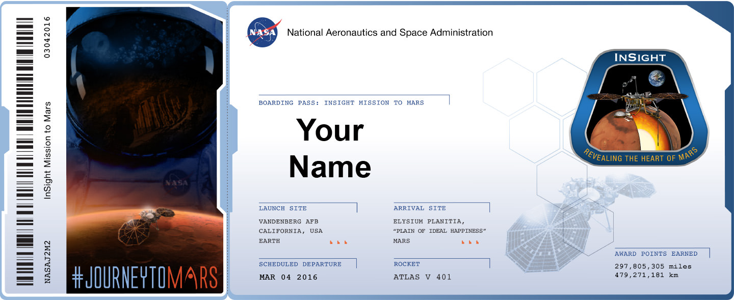
And you can also print out an elegant looking ‘Boarding Pass’ that looks like this:

Boarding Pass for NASA’s InSight Mission to Mars - launching from Vandenberg Air Force Base, California in March 2016.  Credit: NASA
Boarding Pass with frequent flyer miles for NASA’s InSight Mission to Mars – launching from Vandenberg Air Force Base, California in March 2016. Credit: NASA

Furthermore the ‘Boarding Pass’ also comes with a listing of your “frequent flier” points accumulated by your participation in NASA’s ‘fly-your-name opportunity’ that will span multiple missions and multiple decades beyond low Earth orbit.

InSight represents the second ‘fly-your-name opportunity’ in NASA’s journey to Mars program. The uncrewed Orion EFT-1 mission launched on Dec. 5, 2014 was the first chance for space fans to collect ‘Journey to Mars’ points by sending your names to space.

The ‘Send Your Name to Mars’ campaign for Orion EFT-1 was a huge success.

Over 1.38 million people flew on the silicon chip aboard the maiden flight of Orion, the NASA capsule that will eventually transport humans to the Red Planet in the 2030s.

Don’t dawdle. Because after InSight, you’ll have to wait about three years until late 2018 and the blastoff of the next Orion capsule on NASA’s Exploration Mission-1 (EM-1) for you next chance to accumulate “frequent flier” points on a ‘Journey to Mars’ mission.

Orion EM-1 will launch atop NASA’s mammoth Space Launch System (SLS) rocket, and NASA just conducted a key test firing on Aug. 13 of the first stage engines that will power the stack to on a mission to the Moon – detailed in my recent story here.

InSight, which stands for Interior Exploration Using Seismic Investigations, Geodesy and Heat Transport, is a stationary lander.

It will join NASA’s surface science exploration fleet currently comprising of the Curiosity and Opportunity missions which by contrast are mobile rovers.

InSight is the first mission to understand the interior structure of the Red Planet. Its purpose is to elucidate the nature of the Martian core, measure heat flow and sense for “Marsquakes.”

“It will place the first seismometer directly on the surface of Mars to measure Martian quakes and use seismic waves to learn about the planet’s interior. It also will deploy a self-hammering heat probe that will burrow deeper into the ground than any previous device on the Red Planet. These and other InSight investigations will improve our understanding about the formation and evolution of all rocky planets, including Earth,” says NASA.

NASA's InSight Mars lander spacecraft in a Lockheed Martin clean room near Denver. As part of a series of deployment tests, the spacecraft was commanded to deploy its solar arrays in the clean room to test and verify the exact process that it will use on the surface of Mars.  Credits: NASA/JPL-Caltech/Lockheed Martin
NASA’s InSight Mars lander spacecraft in a Lockheed Martin clean room near Denver. As part of a series of deployment tests, the spacecraft was commanded to deploy its solar arrays in the clean room to test and verify the exact process that it will use on the surface of Mars. Credits: NASA/JPL-Caltech/Lockheed Martin

The countdown clock is ticking relentlessly towards liftoff in less than seven months time in March 2016.

Insight promises to ‘science the sh**’ out of the heart of Mars!

It is funded by NASA’s Discovery Program as well as several European national space agency’s and countries. Germany and France are providing InSight’s two main science instruments; The HP3 heat probe and the SEIS seismometer through the Deutsches Zentrum für Luft- und Raumfahrt. or German Aerospace Center (DLR) and the Centre National d’Etudes Spatiales (CNES).

“Together, humans and robotics will pioneer Mars and the solar system,” says Green.

InSight Boarding pass

Stay tuned here for Ken’s continuing Earth and planetary science and human spaceflight news.

Ken Kremer

Curiosity Drills Deep into First High Silica Martian Rock on Third Touchdown Anniversary

Curiosity extends robotic arm and conducts sample drilling at “Buckskin” rock target at bright toned “Lion” outcrop at the base of Mount Sharp on Mars, seen at right. Gale Crater eroded rim seen in the distant background at left, in this composite multisol mosaic of navcam raw images taken to Sol 1059, July 30, 2015. Navcam camera raw images stitched and colorized. Inset: MAHLI color camera up close image of full depth drill hole at “Buckskin” rock target on Sol 1060. Credit: NASA/JPL-Caltech/MSSS/Ken Kremer/kenkremer.com/Marco Di Lorenzo

Curiosity extends robotic arm and conducts sample drilling at “Buckskin” rock target at bright toned “Lion” outcrop at the base of Mount Sharp on Mars, seen at right, during August 2015. Gale Crater eroded rim seen in the distant background at left, in this composite multisol mosaic of navcam raw images taken to Sol 1059, July 30, 2015. Navcam camera raw images stitched and colorized. Inset: MAHLI color camera up close image of full depth drill hole at “Buckskin” rock target on Sol 1060. Credit: NASA/JPL-Caltech/MSSS/Ken Kremer/kenkremer.com/Marco Di Lorenzo
Story updated[/caption]

NASA’s Curiosity Mars Science Laboratory (MSL) rover has successfully drilled into the first high silica rock target on Mars after recently discovering this new type of rock that’s unlike any found before – as she is about to mark the 3rd anniversary since the hair-raising touchdown on the Red Planet.

The SUV-sized rover bored a full depth hole into a Mars outcrop at a target dubbed “Buckskin” as commanded by the mission team over the weekend, after first conducting a mini drill test to assess the safety of the intended drill campaign to sample the alien rock interior beneath the Martian crater floor.

“This morning, the MSL operations team was very happy to see that drilling into Buckskin was successful!” said Ken Herkenhoff, Research Geologist at the USGS Astrogeology Science Center and an MSL science team member, in a mission update.

Confirmation of the success of the full depth drilling into “Buckskin” on Sol 1060 at the bright toned “Lion” outcrop came later after receipt of new high resolution images from the rover showing the approximately 1.6 cm (0.63 inch) diameter bore hole next to the initial mini hole test, along with the indicative residue of grey colored tailings from the Martian subsurface seen distributed around the new hole.

“Successful drilling at Buckskin!” added team member Professor John Bridges of the University of Leicester, England, in an update.

“Like the other drill holes this is showing how thin red Mars is,” Bridges elaborated.

Beneath a thin veneer of rusty red colored iron oxide, the Red Planet is remarkably grey as demonstrated by Curiosity’s prior drilling campaigns.

The hole was bored to a full depth of about 2.6 inches (6.5 centimeters) using the percussion drill on the terminus of the 7 foot-long (2.1 meter-long) robotic arm.

Curiosity rover successfully drills into Martian outcrop  at Buckskin rock target at current work site at base of Mount Sharp in August 2015, in this mosaic showing full depth drill hole and initial test hole, with grey colored subsurface tailings and mineral veins on surrounding Red Planet terrain.  This high resolution photo mosaic is a multisol composite of color images taken by the mast mounted Mastcam-100 color camera up to Sol 1060, July 31, 2015.   Credit:  NASA/JPL-Caltech/Ken Kremer/kenkremer.com/Marco Di Lorenzo
Curiosity rover successfully drills into Martian outcrop at Buckskin rock target at current work site at base of Mount Sharp in August 2015, in this mosaic showing full depth drill hole and initial test hole, with grey colored subsurface tailings and mineral veins on surrounding Red Planet terrain. This high resolution photo mosaic is a multisol composite of color images taken by the mast mounted Mastcam-100 color camera up to Sol 1060, July 31, 2015. Credit: NASA/JPL-Caltech/Ken Kremer/kenkremer.com/Marco Di Lorenzo

Buckskin was “chosen because this sedimentary horizon has some very high silica enrichments,” Bridges explains.

The findings of elevated levels of silicon as well as hydrogen were derived from data collected by Curiosity’s laser-firing Chemistry & Camera (ChemCam) and Dynamic Albedo of Neutrons (DAN) instruments on certain local area rocks.

Silica is a rock-forming compound containing silicon and oxygen, commonly found on Earth as quartz.

“High levels of silica could indicate ideal conditions for preserving ancient organic material, if present, so the science team wants to take a closer look,” say mission team officials.

See the rover at work reaching out with her robotic arm and drilling into Buckskin, as illustrated in our new mosaics of mastcam and navcam camera raw images created by the image processing team of Ken Kremer and Marco Di Lorenzo (above and below).

“Buckskin” sits at the base of Mount Sharp, a huge layered mountain that dominates the center of the 96 mile-wide (154 kilometers-wide) Gale Crater landing site.

Exploring the sedimentary layers of Mount Sharp, which towers 3.4 miles (5.5 kilometers) into the Martian sky, is the primary destination and goal of the rovers long term scientific expedition on the Red Planet.

The silica enrichment “may have occurred as the Gale sediments were altered by subsurface fluids after burial. As the basaltic composition was altered (as we saw from the clay and Fe oxide at Yellowknife Bay) ultimately a lot of silica is released which can be precipitated at horizons like this,” explains Bridges.

The Curiosity Mars Science Laboratory (MSL) rover safely touched down on the crater floor on August 5, 2012 following the unprecedented and nail-biting sky crane maneuver that delivered her with pinpoint precision to a landing site nearby Mount Sharp inside Gale Crater.

The goal of the drilling is to provide geologic context for Curiosity’s long term climb up the mountains sedimentary layers by collecting samples to assess the habitability of the Red Planet over billions of years of time.

So the plan was for the robot to process and pulverize the samples for eventual delivery to the onboard pair of miniaturized chemistry labs located inside her belly – SAM and CheMin. Tiny samples are fed to a trio of inlet ports on the rover deck through the sieved filters.

Images are taken to document and assess the entire sample collection and delivery process.

After gathering the Buckskin sample, a portion was transferred to the robots scoop for inspection.

Then the first portion was successfully fed into CheMin for inorganic elemental analysis over the weekend.

“The activities planned for last weekend completed successfully, including sample dropoff to CheMin and analysis of the minerals present,” Herkenhoff confirmed.

The one ton robots next steps involve “dumping the portion of the drill sample that has not been sieved and Mastcam, ChemCam, MAHLI, and APXS observations of the dump pile. ChemCam and Mastcam will also observe nearby targets “Martz” and “Mountain Home.” MAHLI will image the drill hole, tailings and CheMin inlet at night using its LEDs for illumination.”

Curiosity MAHLI camera image taken of Buckskin drill hole on Sol 1060 on July 31, 2015. Credit: NASA/JPL/MSSS

After completing these science activities, the six wheeled rover will move on to the next exciting destination.

“It’s been a great couple of weeks at the Lion outcrop, but it’s time to move on,” says Lauren Edgar, Research Geologist at the USGS Astrogeology Science Center and an MSL science team member, in the latest mission update from today, August 4, Sol 1065.

“After a successful investigation that included observations by almost every science instrument, we’re getting ready to drive away tomorrow. That means that today (and tomorrow before we drive) is the last call for science observations.”

For about the past two months, the six wheeled robot has been driving around and exploring a geological contact zone named “Marias Pass” – an area on lower Mount Sharp, by examining the rocks and outcrops with her suite of state-of-the-art science instruments.

“Marias Pass” is a geological context zone where two rock types overlap – pale mudstone meets darker sandstone.

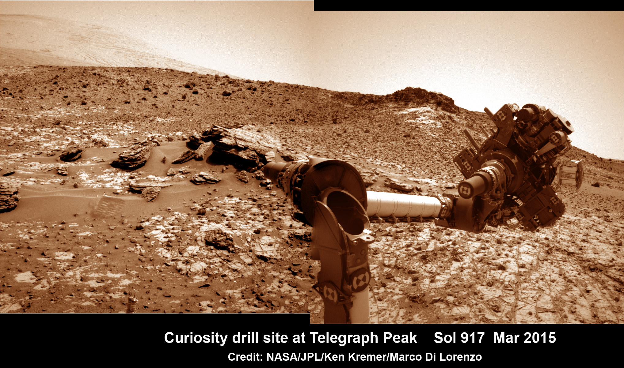
The prior hole was drilled at Telegraph Peak on Feb. 24, 2015, on Sol 908.

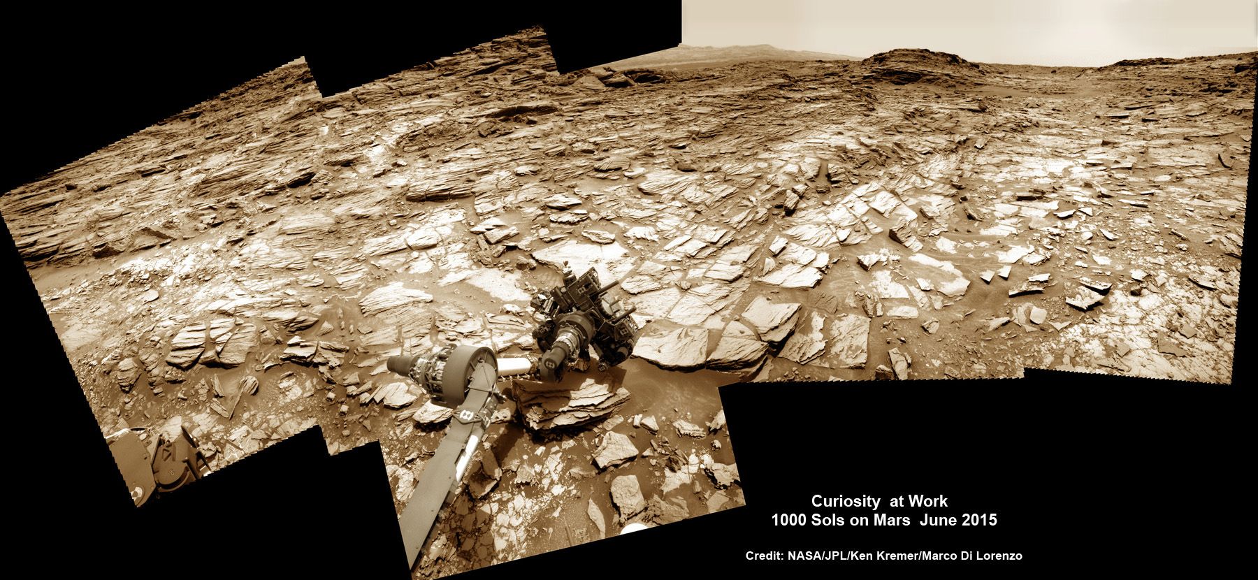
Curiosity recently celebrated 1000 Sols of exploration on Mars on May 31, 2015 – detailed here with our Sol 1000 mosaic also featured at Astronomy Picture of the Day on June 13, 2015.

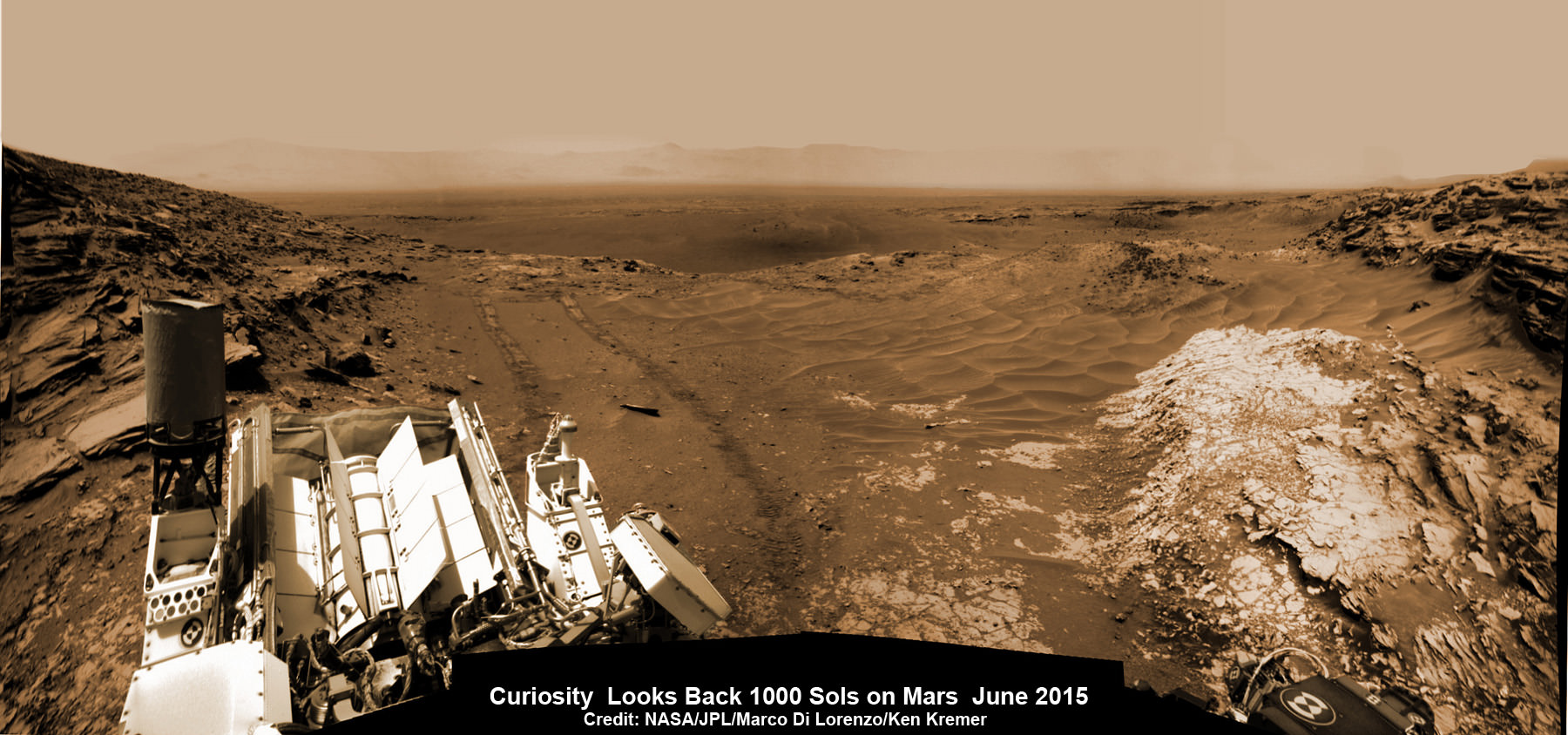
NASA’s Martian Curiosity rover looks backs to 1000 Sols of science and exploration on the surface of the Red Planet.  Robot wheel tracks lead back through valley dunes.  Gale Crater rim seen in the distant hazy background.  Sol 997 (May 28, 2015) navcam camera raw images stitched and colorized. Credit:  NASA/JPL-Caltech/ Marco Di Lorenzo/Ken Kremer/kenkremer.com Featured on APOD on June 13, 2015
NASA’s Martian Curiosity rover looks backs to 1000 Sols of science and exploration on the surface of the Red Planet. Robot wheel tracks lead back through valley dunes. Gale Crater rim seen in the distant hazy background. Sol 997 (May 28, 2015) navcam camera raw images stitched and colorized. Credit: NASA/JPL-Caltech/ Marco Di Lorenzo/Ken Kremer/kenkremer.com
Featured on APOD on June 13, 2015

As of today, Sol 1065, August 4, 2015, she has driven some 11 kilometers and taken over 256,000 amazing images.

Curiosity has already accomplished her primary objective of discovering a habitable zone on the Red Planet – at the Yellowknife Bay area – that contains the minerals necessary to support microbial life in the ancient past when Mars was far wetter and warmer billions of years ago.

Stay tuned here for Ken’s continuing Earth and planetary science and human spaceflight news.
Ken Kremer

Curiosity extends robotic arm and conducts test drill at “Buckskin” rock target at bright toned “Lion” outcrop on the lower region of Mount Sharp on Mars, seen at right.   Gale Crater eroded rim seen in the distant background at left, in this composite multisol mosaic of navcam raw images taken to Sol 1059, July 30, 2015.  Navcam camera raw images stitched and colorized. Credit:  NASA/JPL-Caltech/Ken Kremer/kenkremer.com/Marco Di Lorenzo
Curiosity extends robotic arm and conducts test drill at “Buckskin” rock target at bright toned “Lion” outcrop on the lower region of Mount Sharp on Mars, seen at right. Gale Crater eroded rim seen in the distant background at left, in this composite multisol mosaic of navcam raw images taken to Sol 1059, July 30, 2015. Navcam camera raw images stitched and colorized. Credit: NASA/JPL-Caltech/Ken Kremer/kenkremer.com/Marco Di Lorenzo

Curiosity Discovers Mars Rock Like None Before, Sets Drill Campaign

Curiosity extends robotic arm and conducts test drill at “Buckskin” rock target at bright toned “Lion” outcrop on the lower region of Mount Sharp on Mars, seen at right. Gale Crater eroded rim seen in the distant background at left, in this composite multisol mosaic of navcam raw images taken to Sol 1059, July 30, 2015. Navcam camera raw images stitched and colorized. Credit: NASA/JPL-Caltech/Ken Kremer/kenkremer.com/Marco Di Lorenzo

On the eve of the 3rd anniversary since her nail biting touchdown inside Gale Crater, NASA’s car sized Curiosity Mars Science Laboratory (MSL) rover has discovered a new type of Martian rock that’s surprisingly rich in silica – and unlike any other targets found before.

Excited by this new science finding on Mars, Curiosity’s handlers are now gearing the robot up for her next full drill campaign today, July 31 (Sol 1060) into a rock target called “Buckskin” – which lies at the base of Mount Sharp, the huge layered mountain that is the primary science target of this Mars rover mission.

“The team selected the “Buckskin” target to drill,” says Lauren Edgar, Research Geologist at the USGS Astrogeology Science Center and an MSL science team member, in a mission update.

“It’s another exciting day on Mars!”

See the rover at work reaching out with her robotic arm and drilling into Buckskin, as illustrated in our new mosaics of navcam camera images created by the image processing team of Ken Kremer and Marco Di Lorenzo (above and below). Also featured at Alive Universe Images – here.

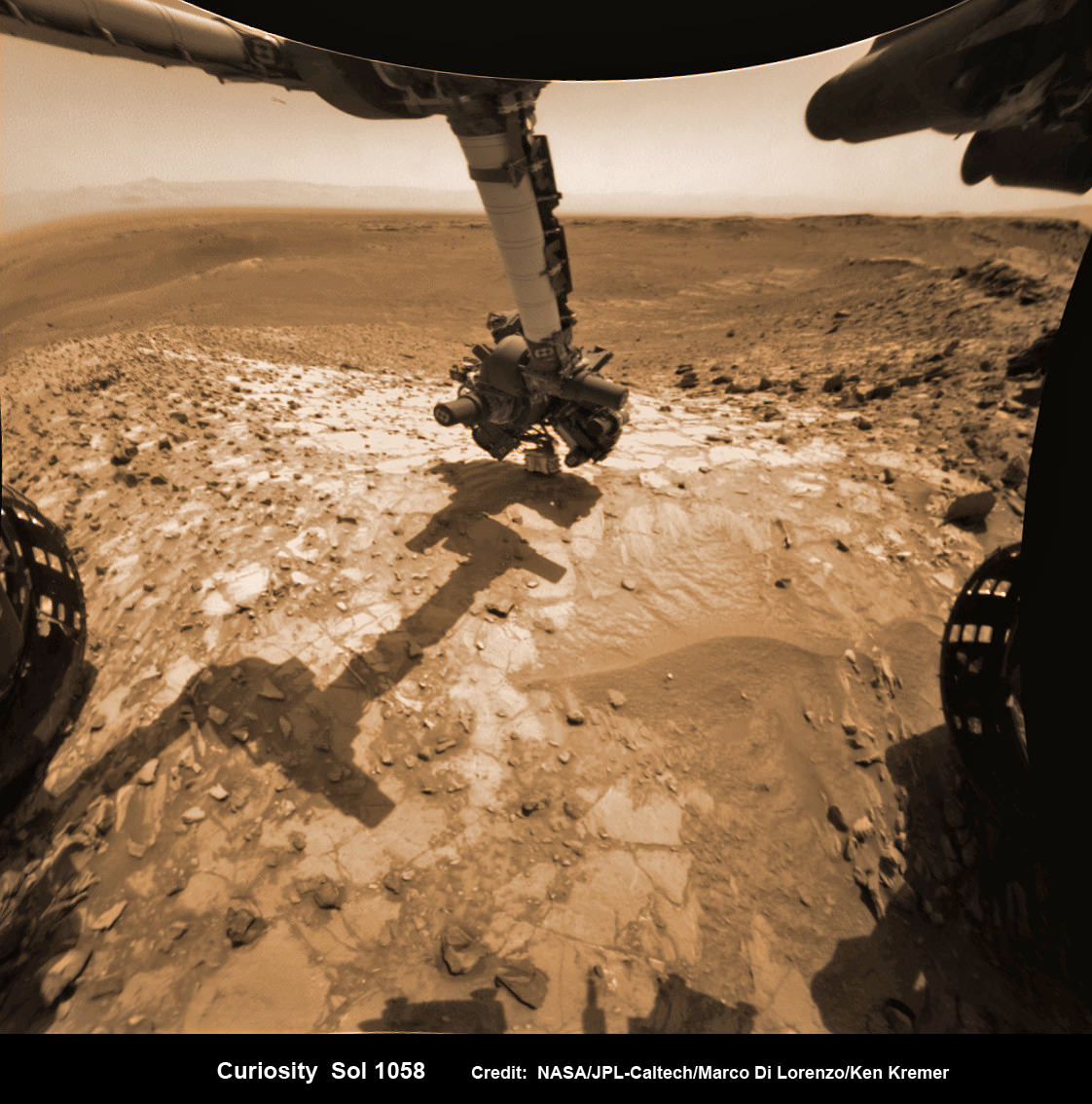
NASA Curiosity rover inspects ‘Buckskin’ rock outcrop on Mars with APXS mineral spectrometer in this hazcam camera raw image taken on July 29, 2015 (Sol 1058), colorized and linearized.  Credit:  NASA/JPL-Caltech/Marco Di Lorenzo/Ken Kremer/kenkremer.com
NASA Curiosity rover inspects ‘Buckskin’ rock outcrop on Mars with APXS mineral spectrometer in this hazcam camera raw image taken on July 29, 2015 (Sol 1058), colorized and linearized. Credit: NASA/JPL-Caltech/Marco Di Lorenzo/Ken Kremer/kenkremer.com

For about the past two months, the six wheeled robot has been driving around and exploring a geological contact zone named “Marias Pass” – an area on lower Mount Sharp, by examining the rocks and outcrops with her suite of state-of-the-art science instruments.

The goal is to provide geologic context for her long term expedition up the mountains sedimentary layers to study the habitability of the Red Planet over eons of time.

Data from Curiosity’s “laser-firing Chemistry & Camera (ChemCam) and Dynamic Albedo of Neutrons (DAN), show elevated amounts of silicon and hydrogen, respectively,” in certain local area rocks, according to the team.

Silica is a rock-forming compound containing silicon and oxygen, commonly found on Earth as quartz.

“High levels of silica could indicate ideal conditions for preserving ancient organic material, if present, so the science team wants to take a closer look.”

Curiosity conducts test drill at “Buckskin” rock target at bright toned “Lion” outcrop on the lower region of Mount Sharp on Mars.   Gale crater rim seen in the distant background, in this composite mosaic of navcam raw images taken to Sol 1059, July 30, 2015.  Navcam camera raw images stitched and colorized. Credit:  NASA/JPL-Caltech/Ken Kremer/kenkremer.com/Marco Di Lorenzo  Inset: MAHLI camera up close image of  test drill at “Buckskin” rock target.  Credit: NASA/JPL-Caltech/MSSS
Curiosity extends robotic arm and conducts test drill at “Buckskin” rock target at bright toned “Lion” outcrop on the lower region of Mount Sharp on Mars. Gale crater rim seen in the distant background, in this composite mosaic of navcam raw images taken to Sol 1059, July 30, 2015. Inset: MAHLI camera up close image of test drill at “Buckskin” rock target. Navcam camera raw images stitched and colorized. Credit: NASA/JPL-Caltech/Ken Kremer/kenkremer.com/Marco Di Lorenzo Credit: NASA/JPL-Caltech/MSSS

Therefore the team scouted targets suitable for in depth analysis and sample drilling and chose “Buckskin”.

“Buckskin” is located among some high-silica and hydrogen enriched targets at a bright outcrop named “Lion.”

An initial test bore operation was conducted first to confirm whether that it was indeed safe to drill into “Buckskin” and cause no harm to the rover before committing to the entire operation.

The bore hole is about 1.6 cm (0.63 inch) in diameter.

“This test will drill a small hole in the rock to help determine whether it is safe to go ahead with the full hole,” elaborated Ryan Anderson, planetary scientist at the USGS Astrogeology Science Center and an MSL science team member.

So it was only after the team received back new high resolution imagery last night from the arm-mounted MAHLI camera which confirmed the success of the mini-drill operation, that the “GO” was given for a full depth drill campaign. MAHLI is short for Mars Hand Lens Imager.

“We successfully completed a mini drilling test yesterday (shown in the MAHLI image). That means that today we’re going for the FULL drill hole” Edgar confirmed.

“GO for Drilling.”

So it’s a busy day ahead on the Red Planet, including lots of imaging along the way to document and confirm that the drilling operation proceeds safely and as planned.

“First we’ll acquire MAHLI images of the intended drill site, then we’ll drill, and then we’ll acquire more MAHLI images after drilling,” Edgar explains.

“The plan also includes Navcam imaging of the workspace, and Mastcam imaging of the target and drill bit. In addition to drilling, we’re getting CheMin ready to receive sample in an upcoming plan. Fingers crossed!” Surface observations with the arm-mounted Alpha Particle X-ray Spectrometer (APXS) instrument are also planned.

If all goes well, the robot will process and pulverize the samples for eventual delivery to the onboard pair of miniaturized chemistry labs located inside her belly – SAM and CheMin. Tiny samples will be fed to the inlet ports on the rover deck through the sieved filters.

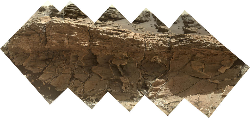
A rock outcrop dubbed "Missoula," near Marias Pass on Mars, is seen in this image mosaic taken by the Mars Hand Lens Imager on NASA's Curiosity rover. Pale mudstone (bottom of outcrop) meets coarser sandstone (top) in this geological contact zone, which has piqued the interest of Mars scientists.   Credit: NASA/JPL-Caltech/MSSS
A rock outcrop dubbed “Missoula,” near Marias Pass on Mars, is seen in this image mosaic taken by the Mars Hand Lens Imager on NASA’s Curiosity rover. Pale mudstone (bottom of outcrop) meets coarser sandstone (top) in this geological contact zone, which has piqued the interest of Mars scientists. Credit: NASA/JPL-Caltech/MSSS

Meanwhile the team is studying a nearby rock outcrop called “Ch-paa-qn” which means “shining peak” in the native Salish language of northern Montana.”

Anderson says the target is a bright patch on a nearby outcrop. Via active and passive observations with the mast-mounted ChemCam laser and Mastcam multispectral imager, the purpose is to determine if “Ch-paa-qn” is comprised of calcium sulfate like other white veins visible nearby, or perhaps it’s something else entirely.

A rock fragment dubbed "Lamoose" is shown in this picture taken by the Mars Hand Lens Imager (MAHLI) on NASA's Curiosity rover. Like other nearby rocks in a portion of the "Marias Pass" area of Mt. Sharp, Mars, it has unusually high concentrations of silica. The high silica was first detected in the area by the Chemistry & Camera (ChemCam) laser spectrometer. This rock was targeted for follow-up study by the MAHLI and the arm-mounted Alpha Particle X-ray Spectrometer (APXS).  Credits: NASA/JPL-Caltech/MSSS
A rock fragment dubbed “Lamoose” is shown in this picture taken by the Mars Hand Lens Imager (MAHLI) on NASA’s Curiosity rover. Like other nearby rocks in a portion of the “Marias Pass” area of Mt. Sharp, Mars, it has unusually high concentrations of silica. The high silica was first detected in the area by the Chemistry & Camera (ChemCam) laser spectrometer. This rock was targeted for follow-up study by the MAHLI and the arm-mounted Alpha Particle X-ray Spectrometer (APXS). Credits: NASA/JPL-Caltech/MSSS

Before arriving by the “Lion” outcrop last week, Curiosity was investigating another outcrop area nearby, the high-silica target dubbed “Elk” with the ChemCam instrument, while scouting around the “Marias Pass” area in search of tasty science targets for in-depth analysis.

Sometimes the data subsequently returned and analyzed is so extraordinary, that the team decides on a return trip to a spot previously departed. Such was the case with “Elk” and the rover was commanded to do a U-turn to acquire more precious data.

“One never knows what to expect on Mars, but the Elk target was interesting enough to go back and investigate,” said Roger Wiens, the principal investigator of the ChemCam instrument from the Los Alamos National Laboratory in New Mexico.

Soon, ChemCam will have fired on its 1,000th target. Overall the laser blaster has been fired more than 260,000 times since Curiosity landed inside the nearly 100 mile wide Gale Crater on Mars on Aug. 6, 2012, alongside Mount Sharp.

“ChemCam acts like eyes and ears of the rover for nearby objects,” said Wiens.

“Marias Pass” is a geological context zone where two rock types overlap – pale mudstone meets darker sandstone.

The rover spotted a very curious outcrop named “Missoula.”

“We found an outcrop named Missoula where the two rock types came together, but it was quite small and close to the ground. We used the robotic arm to capture a dog’s-eye view with the MAHLI camera, getting our nose right in there,” said Ashwin Vasavada, the mission’s project scientist at NASA’s Jet Propulsion Laboratory in Pasadena, California.

White mineral veins, possibly comprised of calcium sulfate, filled the fractures by depositing the mineral from running groundwater.

“Such clues help scientists understand the possible timing of geological events,” says the team.

Read more about Curiosity in an Italian language version of this story at Alive Universe Images – here.

NASA’s Martian Curiosity rover looks backs to 1000 Sols of science and exploration on the surface of the Red Planet.  Robot wheel tracks lead back through valley dunes.  Gale Crater rim seen in the distant hazy background.  Sol 997 (May 28, 2015) navcam camera raw images stitched and colorized. Credit:  NASA/JPL-Caltech/ Marco Di Lorenzo/Ken Kremer/kenkremer.com
NASA’s Martian Curiosity rover looks backs to 1000 Sols of science and exploration on the surface of the Red Planet. Robot wheel tracks lead back through valley dunes. Gale Crater rim seen in the distant hazy background. Sol 997 (May 28, 2015) navcam camera raw images stitched and colorized. Credit: NASA/JPL-Caltech/ Marco Di Lorenzo/Ken Kremer/kenkremer.com
Featured on APOD on June 13, 2015

As of today, Sol 1060, July 31, 2015, she has taken over 255,000 amazing images.

Curiosity recently celebrated 1000 Sols of exploration on Mars on May 31, 2015 – detailed here with our Sol 1000 mosaic also featured at Astronomy Picture of the Day on June 13, 2015.

Stay tuned here for Ken’s continuing Earth and planetary science and human spaceflight news.

Ken Kremer

Red Mars, Gray Mars: "Mini-start hole" drill maneuver was successful.  Image of mini start drill hole taken by Mars Hand Lens Imager (MAHLI) aboard NASA's Mars rover Curiosity on July 30, 2015, Sol 1059. Credit: NASA/JPL-Caltech/MSSS
Red Mars, Gray Mars: “Mini-start hole” drill maneuver was successful. Image of mini start drill hole taken by Mars Hand Lens Imager (MAHLI) aboard NASA’s Mars rover Curiosity on July 30, 2015, Sol 1059. Credit: NASA/JPL-Caltech/MSSS
Curiosity conducts test drill at “Buckskin” rock target at bright toned “Lion” outcrop on the lower region of Mount Sharp on Mars, seen at right.   Gale crater rim seen in the distant background at left, in this composite mosaic of navcam raw images taken to Sol 1059, July 30, 2015.  Navcam camera raw images stitched. Credit:  NASA/JPL-Caltech/Ken Kremer/kenkremer.com/Marco Di Lorenzo
Curiosity extends robotic arm and conducts test drill at “Buckskin” rock target at bright toned “Lion” outcrop on the lower region of Mount Sharp on Mars, seen at right. Gale crater rim seen in the distant background at left, in this composite mosaic of navcam raw images taken to Sol 1059, July 30, 2015. Navcam camera raw images stitched. Credit: NASA/JPL-Caltech/Ken Kremer/kenkremer.com/Marco Di Lorenzo

Dazzling Gallery From India’s MOM Mars Orbiter Camera

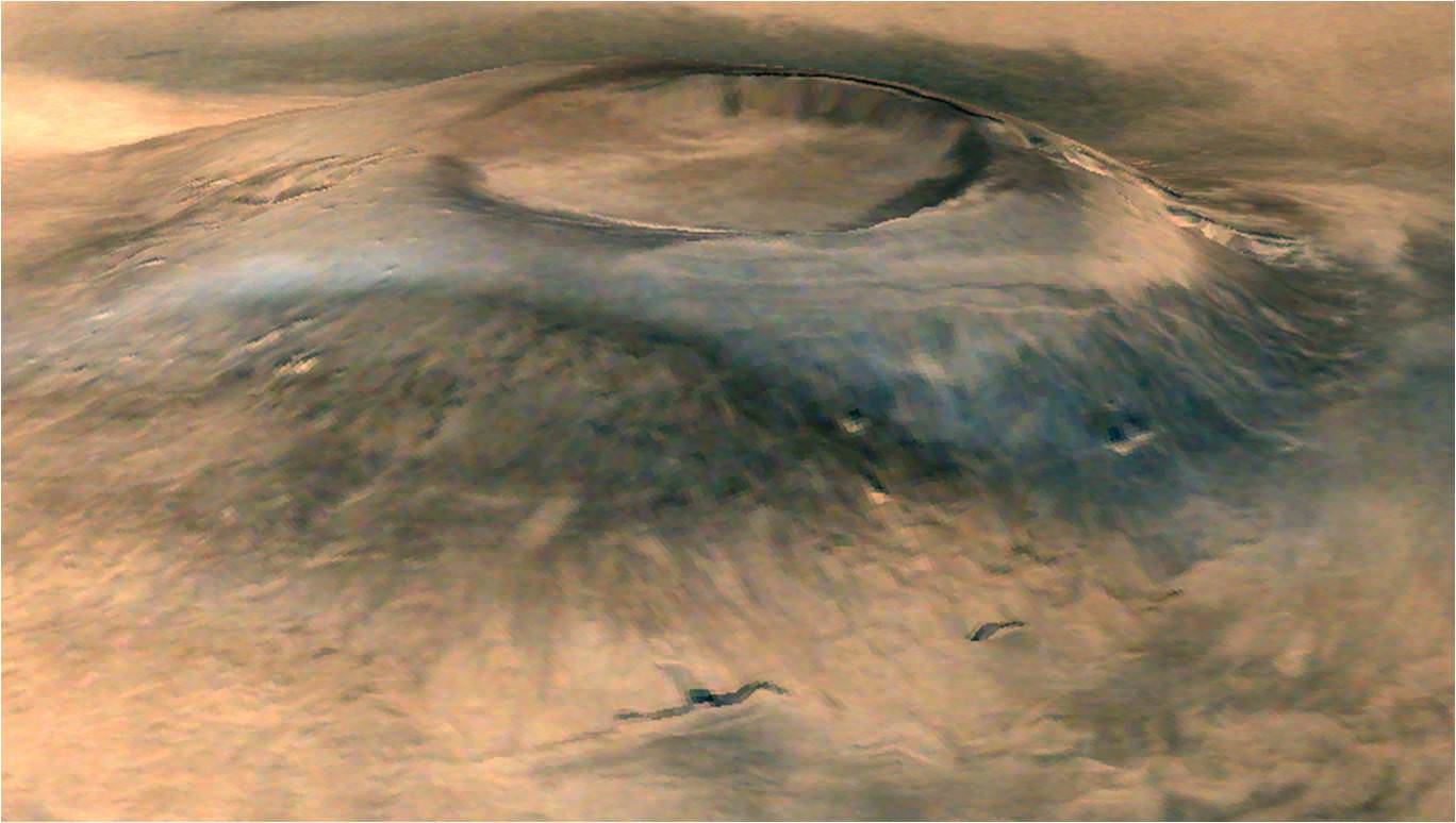
Spectacular 3D view of Arsia Mons, a huge volcano on Mars, taken by camera on India's Mars Orbiter Mission (MOM). Credit: ISRO

Spectacular 3D view of Arsia Mons, a huge volcano on Mars, taken by camera on India’s Mars Orbiter Mission (MOM). Credit: ISRO
Story updated with more details and imagery[/caption]

India’s first ever robotic explorer to the Red Planet, the Mars Orbiter Mission, more affectionately known as MOM, has captured an absolutely dazzling array of images of the fourth rock from the Sun.

The Indian Space Research Organization (ISRO), India’s space agency, has recently published a beautiful gallery of images featuring a variety of picturesque Martian canyons, volcanoes, craters, moons and more.

We’ve gathered a collection here of MOM’s newest imagery snapped by the probes Mars Color Camera (MCC) for the enjoyment of Martian fans worldwide.

The spectacular 3D view of the Arsia Mons volcano, shown above, was “created by draping the MCC image on topography of the region derived from the Mars Orbiter Laser Altimeter (MOLA), one of five instruments on board NASA’s Mars Global Surveyor (MGS) spacecraft.

The Arsia Mons image was taken from Mars orbit on 1 April 2015 at a spatial resolution of 556 meters from an altitude of 10707 km. Volcanic deposits can be seen located at the flanks of the Mons, according to ISRO.

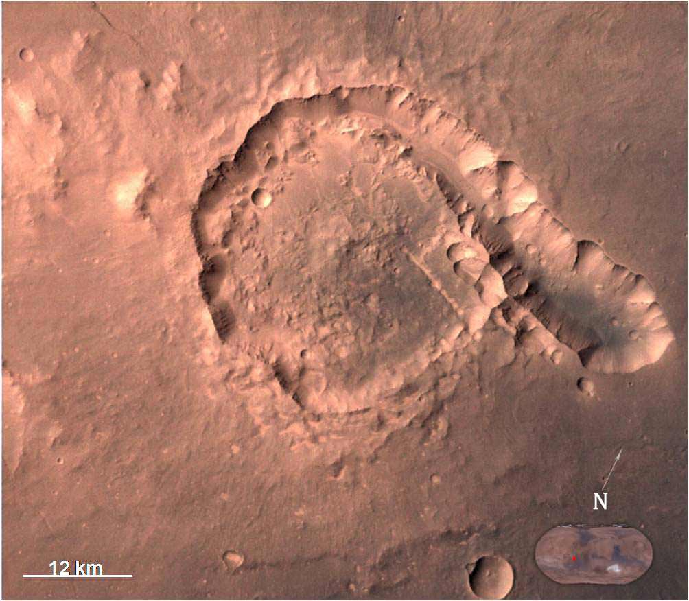
The view of Pital crater below was released in late May and taken on 23 April 2015. Pital is a 40 km wide impact crater located in the Ophir Planum region of Mars and the image shows a chain of small impact craters. It is located in the eastern part of Valles Marineris region, says an ISRO description. MCC took the image from an altitude of 808 km.

Pital crater is an impact crater located in Ophir Planum region of Mars, which is located in the eastern part of Valles Marineris region. This  image is taken by Mars Color Camera (MCC) on 23-04-2015 at a spatial resolution of  ~42 m from an altitude of 808 km. Credit: ISRO
Pital crater is an impact crater located in Ophir Planum region of Mars, which is located in the eastern part of Valles Marineris region. This image is taken by Mars Color Camera (MCC) on 23-04-2015 at a spatial resolution of ~42 m from an altitude of 808 km. Credit: ISRO

It is an odd shaped crater, neither circular nor elliptical in shape, possibly due to “regional fracture in the W-E trending fracture zone.”

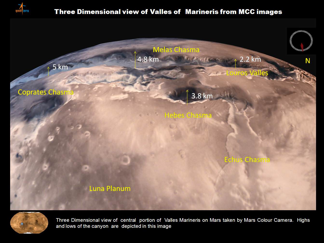
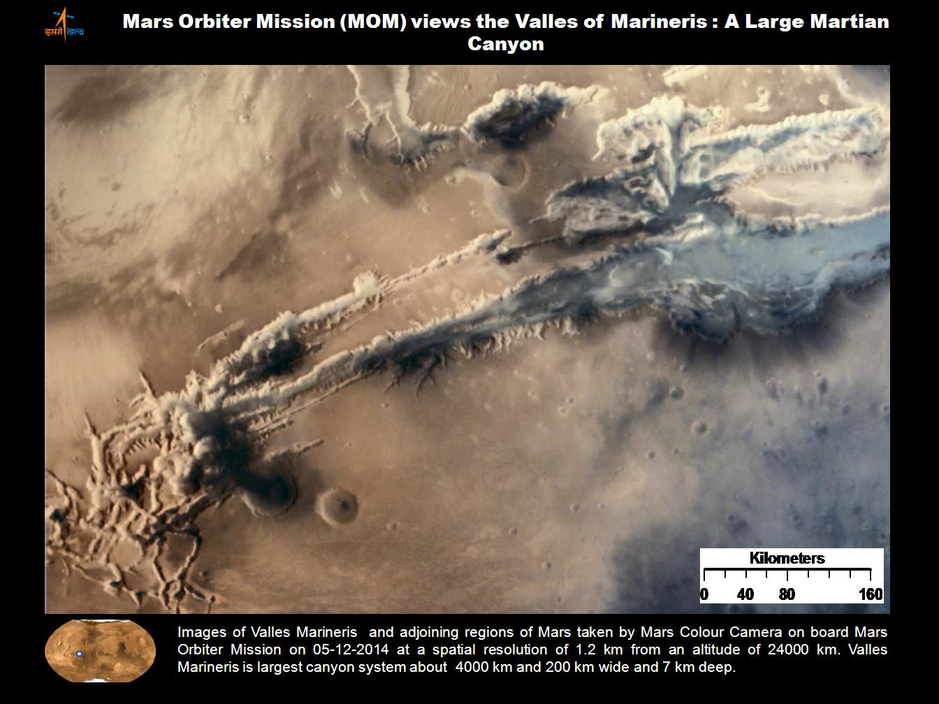
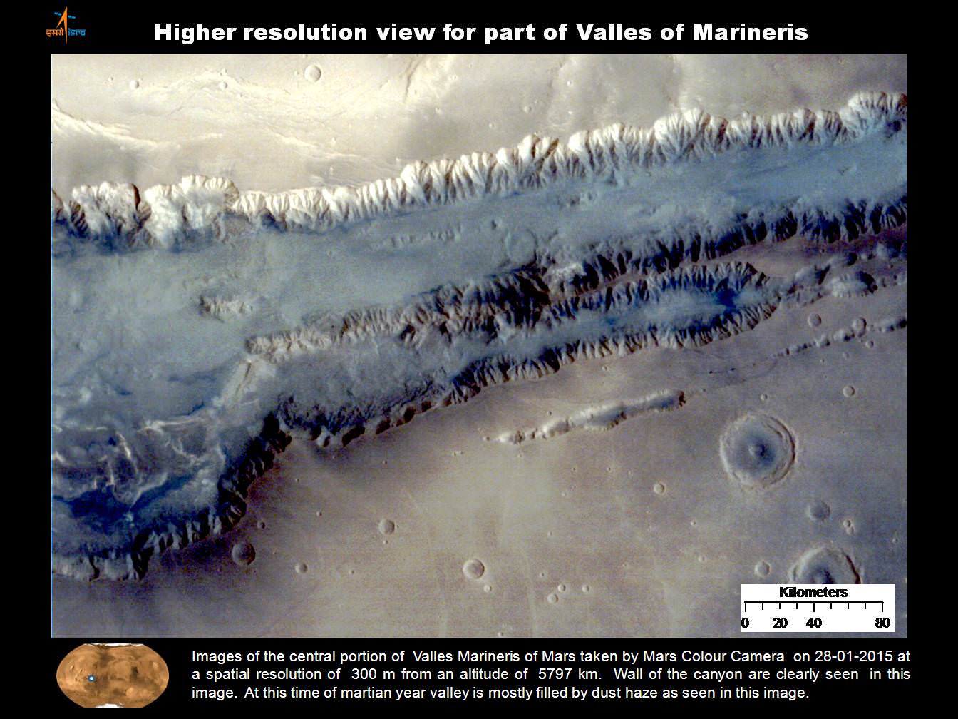
A trio of images, including one in stunning 3D, shows various portions of Valles Marineris, the largest known canyon in the Solar System.

Three dimensional view of Valles Marineris center portion from India’s MOM Mars Mission.   Credit: ISRO
Three dimensional view of Valles Marineris center portion from India’s MOM Mars Mission. Credit: ISRO

Valles Marineris stretches over 4,000 km (2,500 mi) across the Red Planet , is as much as 600 km wide and measures as much as 7 kilometers (4 mi) deep.

Valles Marineris from India’s Mars Mission.   Credit: ISRO
Valles Marineris from India’s Mars Mission. Credit: ISRO

For context here’s a previously taken global image of the red planet from MOM showing Valles Marinaris and Arsia Mons, which belongs to the Tharsis Bulge trio of shield volcanoes. They are both near the Martian equator.

Olympus Mons, Tharsis Bulge trio of volcanoes and Valles Marineris from ISRO's Mars Orbiter Mission. Note the clouds and south polar ice cap.   Credit: ISRO
Olympus Mons, Tharsis Bulge trio of volcanoes and Valles Marineris from ISRO’s Mars Orbiter Mission. Note the clouds and south polar ice cap. Credit: ISRO

Valles Marineris is often called the “Grand Canyon of Mars.” It spans about as wide as the entire United States.

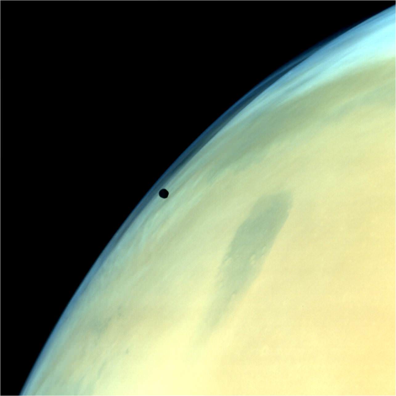
A gorgeous view of Phobos, the largest of Mars’ two tiny moons, silhouetted against the surface is shown below.

Phobos, one of the two natural satellites of Mars silhouetted against the Martian surface.  Credit: ISRO
Phobos, one of the two natural satellites of Mars silhouetted against the Martian surface. Credit: ISRO

MOM’s goal is to study Mars atmosphere, surface environments, morphology, and mineralogy with a 15 kg (33 lb) suite of five indigenously built science instruments. It is also sniffing for methane, a potential marker for biological activity.

MOM is India’s first deep space voyager to explore beyond the confines of her home planets influence and successfully arrived at the Red Planet after the “history creating” orbital insertion maneuver on Sept. 23/24, 2014 following a ten month journey from Earth.
MOM swoops around Mars in a highly elliptical orbit whose nearest point to the planet (periapsis) is at about 421 km and farthest point (apoapsis) at about 76,000 km, according to ISRO.

It takes MOM about 3.2 Earth days or 72 hours to orbit the Red Planet.

Higher resolution view of a portion of Valles Marineris canyon from India’s MOM Mars Mission.   Credit: ISRO
Higher resolution view of a portion of Valles Marineris canyon from India’s MOM Mars Mission. Credit: ISRO

MOM was launched on Nov. 5, 2013 from India’s spaceport at the Satish Dhawan Space Centre, Sriharikota, atop the nations indigenous four stage Polar Satellite Launch Vehicle (PSLV) which placed the probe into its initial Earth parking orbit.

The $73 million MOM mission was expected to last at least six months. In March, ISRO extended the mission duration for another six months since its healthy, the five science instruments are operating fine and it has sufficient fuel reserves.

And with a communications blackout between Mars and Earth imminent as a result of natures solar conjunction, it’s the perfect time to catch up on all things Martian.

Solar conjunctions occur periodically between Mars and Earth about every 26 months, when the two planets line up basically in a straight line geometry with the sun in between as the two planets travel in their sun-centered orbits.

Since Mars will be located behind the Sun for most of June, communications with all the Terran spacecraft at the planet is diminished to nonexistent.

“MOM faces a communication outage during June 8-25,” according to The Hindu.

Normal science operations resume thereafter.

“Fuel on the spacecraft is not an issue,” ISRO Satellite Centre Director M. Annadurai told The Hindu.

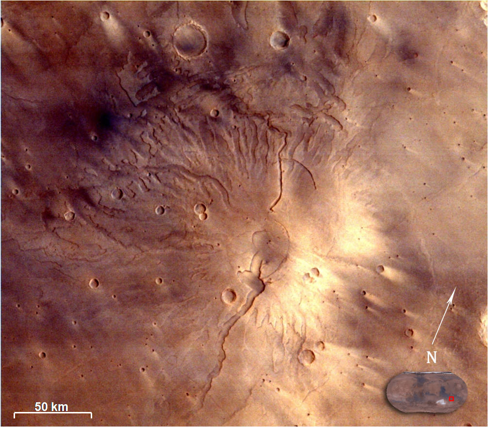
Image of Tyrrhenus Mons in Hesperia Planum region taken by Mars Color Camera (MCC) on 25-02-2015 at a spatial resolution of 166m from an altitude of 3192km.  Tyrrhenus Mons is an ancient martian volcano and image shows its timeworn gullies and wind streaks.  Credit: ISRO
Image of Tyrrhenus Mons in Hesperia Planum region taken by Mars Color Camera (MCC) on 25-02-2015 at a spatial resolution of 166m from an altitude of 3192km. Tyrrhenus Mons is an ancient martian volcano and image shows its timeworn gullies and wind streaks. Credit: ISRO

Including MOM, Earth’s invasion fleet at the Red Planet numbers a total of seven spacecraft comprising five orbiters from NASA, ESA and ISRO as well as the sister pair of mobile surface rovers from NASA – Curiosity and Opportunity.

Stay tuned here for Ken’s continuing Earth and planetary science and human spaceflight news.

Ken Kremer

The Martian Curiosity Looks Back on 1000 Sols of Exploration on the Red Planet

NASA’s Martian Curiosity rover looks backs to 1000 Sols of science and exploration on the surface of the Red Planet. Robot wheel tracks lead back through valley dunes. Gale Crater rim seen in the distant hazy background. Sol 997 (May 28, 2015) navcam camera raw images stitched and colorized. Credit: NASA/JPL-Caltech/ Marco Di Lorenzo/Ken Kremer/kenkremer.com Featured on APOD on June 13, 2015

Looking back 1000 Sols on the Red Planet
NASA’s Martian Curiosity rover looks backs to 1000 Sols of science and exploration on the surface of the Red Planet. Robot wheel tracks lead back through valley dunes. Gale Crater rim seen in the distant hazy background. Sol 997 (May 28, 2015) navcam camera raw images stitched and colorized. Credit: NASA/JPL-Caltech/ Marco Di Lorenzo/Ken Kremer/kenkremer.com
Featured on APOD on June 13, 2015
Story updated[/caption]

The Martian Curiosity celebrates 1000 Sols on Mars!

Marking the occasion with utter glee, the car sized robot snapped a cool mosaic view (above) looking back to 1000 Sols of high impact exploration and discovery on the Red Planet, showing her wheel tracks leading back through valley dunes from the foothills of humongous Mount Sharp and across the alien surface floor and out to the distant rim of the Gale Crater landing site she descended to nearly three years ago in August 2012.

“A thousand thanks to the best team a rover could have. Celebrating 1,000 sols. Here’s to the Martian days ahead!” the robot tweeted.

But at 1K sols she’s not content to just bask in the Martian sunshine during the history making event. Rather, she is as always hard at work, reaching out with the high tech robotic arm and inspecting intriguing rock outcrops spread out all around her.

Check out Curiosity’s current workspace, looking back and hard at work in our new photo mosaics herein created by the imaging team of Marco Di Lorenzo and Ken Kremer. They are also featured at NBC News – here – and Alive Space Images (in Italian) – here and here.

Curiosity rover at work for 1000 Sols on Mars.  This composite multi sol photo mosaic shows outstretched robotic arm inspecting intriguing rock outcrops.   The APXS spectrometer is investigating a target called ‘Ronan’ on the Stimson overlying outcrop.   Navcam camera raw images taken from sols 997 to 1000 are stitched and colorized.  Credit: NASA/JPL/Ken Kremer/kenkremer.com/Marco Di Lorenzo
Curiosity rover at work for 1000 Sols on Mars
This composite multi sol photo mosaic shows outstretched robotic arm inspecting intriguing rock outcrops. The APXS spectrometer is investigating a target called ‘Ronan’ on the Stimson overlying outcrop. Navcam camera raw images taken from sols 997 to 1000 are stitched and colorized. Credit: NASA/JPL/Ken Kremer/kenkremer.com/Marco Di Lorenzo

The raw images for the look back mosaic were taken after she arrived at her current location on Martian Sol 997, or Earth’s Day May 28, 2015.

The Curiosity Mars Science Laboratory (MSL) rover officially celebrated 1000 Martian Sols on May 31, 2015 since she safely touched down on the crater floor on August 5, 2012 following the nail-biting and unprecedented sky crane maneuver that delivered her with pinpoint precision to a landing site nearby Mount Sharp.

“An MSL landmark day. We have reached 1000 sols on Mars. Looking back the remarkable thing is how few serious problems there have been,” says team member Professor John Bridges of the University of Leicester, England, in an update.

Exploring the sedimentary layers of Mount Sharp, which towers 3.4 miles (5.5 kilometers) into the Martian sky, form the primary destination and goal of her scientific expedition.

The six wheeled robot and her team of handlers back on Earth, are eeking out every last drop of science before she and all of Earth’s entire Martian invasion fleet enter solar conjunction, when Mars is behind the sun and little or no communications will be possible for most of the month of June. Activities will be limited per safety protocols.

“However, there is one issue even Curiosity can’t avoid – Conjunction. For much of June, Mars will be obscured from Earth by the Sun. Few science operations,” explains Bridges.

Curiosity rover rolls across Mars at the foothills of Mount Sharp, seen in the background, in this mosaic of images taken on April 11, 2015 (Sol 952).  Navcam camera raw images stitched and colorized. Credit:  NASA/JPL-Caltech/ Marco Di Lorenzo/Ken Kremer/kenkremer.com
Curiosity rover rolls across Mars at the foothills of Mount Sharp, seen in the background, in this mosaic of images taken on April 11, 2015 (Sol 952). Navcam camera raw images stitched and colorized. Credit: NASA/JPL-Caltech/ Marco Di Lorenzo/Ken Kremer/kenkremer.com

NASA’s long-lived Opportunity rover labors on the opposite side of Mars.

After a short drive Curiosity arrived at her current location at “Marias Pass” on Sol 997, where she will stay stationary during the conjunction period out of an abundance of caution.

“A short bump on Sol 997 put Curiosity in a great position to investigate a few different rock units in Marias Pass, using the instruments on the rover’s arm,” wrote MSL and USGS mission scientist Ken Herkenhoff in an update.

She also reached within an eyelash of 10.6 kilometers (6.6 mi) of total driving.

“The 2.5 m drive brings our total odometry to 10,599 m,” noted Herkenoff.

Along the way she discovered the chemical ingredient minerals necessary to support life, as well as low levels of some organic molecules and some traces of methane, and and ample evidence for lakes and streams of liquid water.

“Curiosity is now parked for the next few weeks. But we are parked in front of a beautiful outcrop that shows the contact between the underlying Pahrump unit and the overlying Stimson unit.”

Our arm photo mosaic herein shows the seven foot (2 m) long robotic arm and its APXS spectrometer deployed at the target called “Ronan”, which is part of the overlying Stimson outcrop unit.

The rover is also using the ChemCam, MastCam and MAHLI cameras and spectrometers and other instruments to characterize the outcrop and its texture and composition in detail.

The robotic arm will be stowed during the June conjunction period.

Curiosity arrived at the Pahrump Hills at the base of Mount Sharp back in September 2014. Since then she has conducted an intensive investigation of the rocks and a trio of drilling operations to elucidate how this area fits in context with Mount Sharp and the habitable region discovered on the crater floor at Yellowknife Bay back in the spring of 2013.

In recent weeks, Curiosity has been driving up hills with slopes of as much as 21 degrees, higher than ever before, on an exciting journey endeavoring to slowly ascend up to the lower layers of Mount Sharp.

The current Martian outcrop area under investigation is a place where two distinctive geologic types of bedrock meet and where pale rock meets darker overlying rock.

“Such contacts can reveal clues about how the environmental conditions that produced one type of rock were related to the conditions that produced the other,” says NASA.

“The rover science team wants to examine an outcrop that contains the contact between the pale rock unit the mission analyzed lower on Mount Sharp and a darker, bedded rock unit that the mission has not yet examined up close.”

The team is also scouting around for the presence of mineral veins, like those recently discovered at the “Garden City” outcrop, that formed in the past during periods of flowing liquid water that could be favorable for microbial life forms if they ever existed.

Curiosity investigates a beautiful outcrop of scientifically enticing dark and light mineral veins at ”Garden City” outcrop at the base of Mount Sharp at current location on Mars.   This  photo mosaic was stitched  from Mastcam color camera raw images. Credit:  NASA/JPL-Caltech/MSSS/Ken Kremer/kenkremer.com/Marco Di Lorenzo
Curiosity investigates a beautiful outcrop of scientifically enticing dark and light mineral veins at ”Garden City” outcrop at the base of Mount Sharp at current location on Mars. This photo mosaic was stitched from Mastcam color camera raw images. Credit: NASA/JPL-Caltech/MSSS/Ken Kremer/kenkremer.com/Marco Di Lorenzo

Because there’s a plethora of treacherous dunes, the team has had to monitor operations carefully and alter the route on occasion to maintain safe operations.

Curiosity has already accomplished her primary objective of discovering a habitable zone on the Red Planet that contains the minerals necessary to support microbial life in the ancient past when Mars was far wetter and warmer billions of years ago.

This March 6, 2015 (Sol 917), mosaic of images from the Navcam camera on NASA's Curiosity Mars rover shows the position in which the rover held its arm for several days after a transient short circuit triggered onboard fault-protection programming to halt arm activities on Feb. 27, 2015, Sol 911.  The rover team chose to hold the arm in the same position for several days of tests to diagnose the underlying cause of the Sol 911 event.  Navcam camera raw images stitched and colorized. Credit:  NASA/JPL-Caltech/Ken Kremer/kenkremer.com/Marco Di Lorenzo
This March 6, 2015 (Sol 917), mosaic of images from the Navcam camera on NASA’s Curiosity Mars rover shows the position in which the rover held its arm for several days after a transient short circuit triggered onboard fault-protection programming to halt arm activities on Feb. 27, 2015, Sol 911. The rover team chose to hold the arm in the same position for several days of tests to diagnose the underlying cause of the Sol 911 event. Navcam camera raw images stitched and colorized. Credit: NASA/JPL-Caltech/Ken Kremer/kenkremer.com/Marco Di Lorenzo

To date, Curiosity’s odometer totals over 5.1 miles (8.4 kilometers) since landing inside Gale Crater on Mars in August 2012.

As of today, Sol 1001, June 1, 2015, she has taken over 246,000 amazing images.

Stay tuned here for Ken’s continuing Earth and planetary science and human spaceflight news.

Ken Kremer