Here’s How You Can Download The Earth In High-Resolution

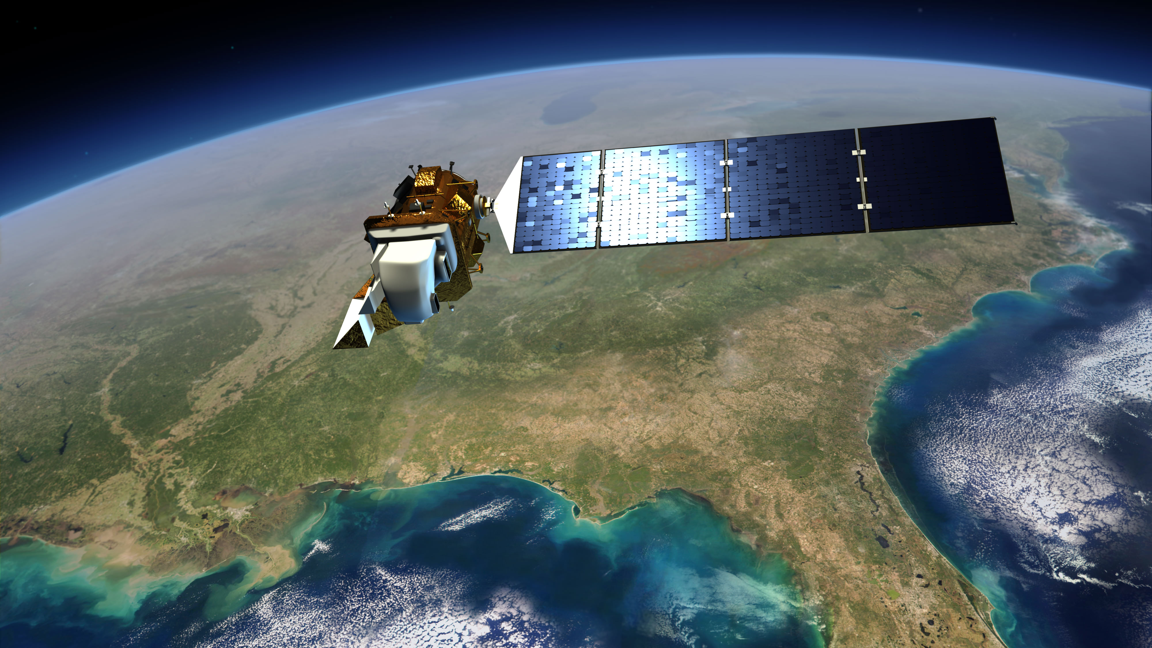
Artist's conception of Landsat 8 (renamed from Landsat Data Continuity Mission). Credit: NASA/ Goddard/Conceptual Image Lab

Landsat 8 officially opened its eyes to Earth yesterday (May 30). Officials are promising the clearest views yet of the four-decade-old Landsat program, and luckily for people who love amazing Earth views, the images Landsat produces are free.

Before talking a bit about Landsat 8, here’s one way you can find the images: go to this website of raw Landsat data from the United States Geological Survey. In the menu tab “Collection”, go down to “Landsat Archive” and select “Landsat 8 OLI.” Then click a location on the map to see if it’s taken a picture of a spot you’re interested in.

Once you’ve selected it, hit “Add Scene”, then click on the scene list at the bottom right of the screen to download the product. (We’d strongly advise consulting the tutorial on that website for more help. You need to register as a user to download the high-resolution images.)

There isn’t much to see there yet, but over the next few months there should be a wealth of pictures to choose from. More spots where Landsat 8 data will appear are listed on this USGS page.

You may better recall Landsat 8 as the Landsat Data Continuity Mission. Launched on Feb. 11, it was first under the operational control of NASA as the agency put the satellite through its paces — placing it into the proper orbit (it circles in a near-polar orbit) and taking some test images of the planet, for example.

Now that the satellite is ready, the USGS has operational control and will add that to more than 40 years of data collected under the Landsat program. The aim, we assure you, is not just for pretty pictures.
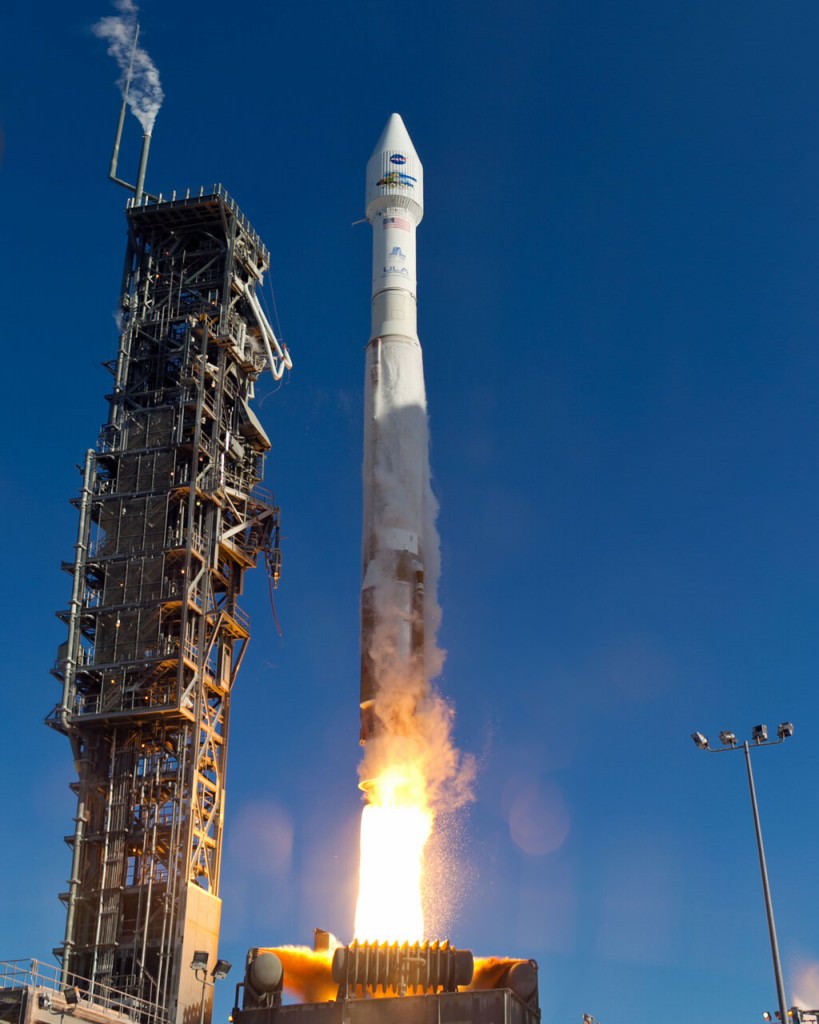
An  Atlas-V rocket with the Landsat Data Continuity Mission (LDCM) spacecraft onboard is seen as it launches on Monday, Feb. 11, 2013 at Vandenberg Air Force Base, California. Credit: NASA
An Atlas-V rocket with the Landsat Data Continuity Mission (LDCM) spacecraft onboard is seen as it launches on Monday, Feb. 11, 2013 at Vandenberg Air Force Base, California. Credit: NASA

Long Earth observation programs show changes in the land over time. We can see cities grow, observe forests shrink or deserts expand in response to human activity or climate change, and also gauge the impact of natural disasters. In the past, Landsat pictures have been used to map the impact of the Mount St. Helen’s eruption of 1980, and to respond to oil gas fires set in Kuwait during the Gulf War of 1991.

These are heavyweight satellites. The truck-sized Landsat 8 weighs 4,566 lbs (2,071 kg) fully loaded with fuel, excluding the weight of the instruments. Its operational land imager can take pictures in nine spectral bands, which is important because certain types of vegetation or land features show up better in different light spectra. (One application is to monitor the health of certain kind of plants in farmer fields, for example.) It also has two thermal infrared sensor bands that will show the heat signature of Earthly features.

For Landsat, officials needed to launch this satellite because its predecessor (Landsat 7)’s operational lifetime is in overtime. Should the satellite have failed before Landsat 8 arrived, 41 years of continuous Earth observations under the same program would have ceased.

Landsat 8 will circle the globe 14 times daily, will repeat its ground track every 16 days, and is expected to do this for at least five years. Check out this USGS feature story for more on how it will contribute to Earth observation.
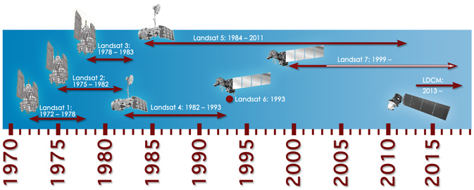
Timeline showing lifespans of the Landsat satellites. Credit: NASA

Awesome View of the Active Pavlov Volcano, as Seen from the Space Station

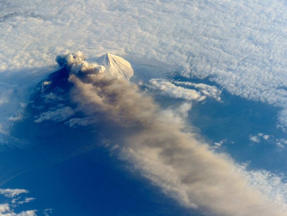
The Pavlof Volcano in Alaska on May 18, 2013. The oblique perspective from the ISS reveals the three dimensional structure of the ash plume, which is often obscured by the top-down view of most remote sensing satellites. Credit: NASA

The Pavlof Volcano began erupting on May 13, 2013, shooting lava into the air and spewing an ash cloud 20,000 feet (6,000 meters) high. This image from the International Space Station was taken on May 18, and provides a unique oblique (sideways) glance at the action. When the photograph was taken, the space station was about 475 miles south-southeast of the volcano (49.1° North latitude, 157.4° West longitude). The volcanic plume extended southeastward over the North Pacific Ocean.

NASA says the oblique perspective reveals the three dimensional structure of the ash plume, which is usually not visible from the top-down views of most remote sensing satellites.

If the volcano keeps erupting and spewing ash at those heights, it could interfere with airline traffic. Pavlov is one of the most frequently erupting volcanoes in the Aleutian arc. It last erupted in August of 2007; it previously had not been active since 1996.

There’s more information — and an impressive set of ground-based images — on the Pavlov Volcano at the Alaska Volcano Observatory website, and here’s a helicopter video of the eruption:

There are also a few more ISS images of the volcano at the NASA Earth Observatory website.

Oklahoma Tornado on May 20, 2013 As Seen from Space

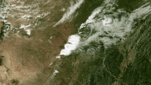
Satellite Image of Oklahoma Tornado. Acquired at 2:55 CT on May 20, 2013, this image from the NOAA GOES-13 satellite shows the storms developing directly over central Oklahoma. One minute later an incredibly destructive tornado touched down in Moore, OK. Credit: NOAA.

The massive tornado that tore through parts of Oklahoma on My 20, 2013 left a 32 km (20-mile) swath of destruction and death, with winds approaching 320 km/hr (200 mph). The US National Weather Service said the 3 km (2-mile)-wide tornado spent 40 minutes on the ground in the area of Moore, Oklahoma, outside of Oklahoma City, destroying schools, a hospital and hundreds of homes, killing dozens of people. Satellite images and video show how the storm developed.

Below is a video showing satellite imagery from the GOES 13 satellite from May 19-20, 2013. It shows the tornado outbreak and supercell thunderstorms that developed across portions of the Great Plains:

Weather satellites help scientists to observe weather patterns from the unique vantage point of space. This provides the ability to see a larger area of the Earth rather than with conventional radar which does not reveal a true overview of cloud structure and wind patterns.

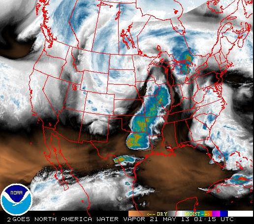
These satellites can measure many different things, such as in the image below, which looks at water vapor content of the clouds. The satellites operated by NASA and NOAA and are equipped to send back images in infrared and other wavelengths, providing snapshots of things like the water vapor measurements, temperatures, wind patterns, cloud coverage, storm movement and many other readings. This information also helps with the prediction of storms, allowing for warnings for people to seek shelter from potentially destructive weather events.

This screenshot shows a false color view of the water vapor content in the clouds during the tornado outbreak in Oklahoma on May 20, 2013, as seen from NOAA geostationary (GOES) satellites. Click on image to go to current NOAA imagery.

The news from Oklahoma is ongoing, and we encourage you to keep current on the latest information from other news sites. But as Phil Plait pointed out, if you are interested in helping the people involved in this tragedy, the Take Part website has a list of organizations that are in the area providing support.

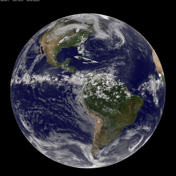
This full-disk view of Earth shows the formation of the Oklahoma tornado, from the Aqua satellite. Credit: NASA Goddard Space Flight Center.

You can see more images from Oklahoma tornado at the NASA Goddard Space Flight Center Flickr page.

Sources: Marshall Space Flight Center Earth Science office, NOAA Satellite Information office, NOAA website, National Weather Service

Stunning New Photo from the Space Station: The Moon Ushers in Dawn

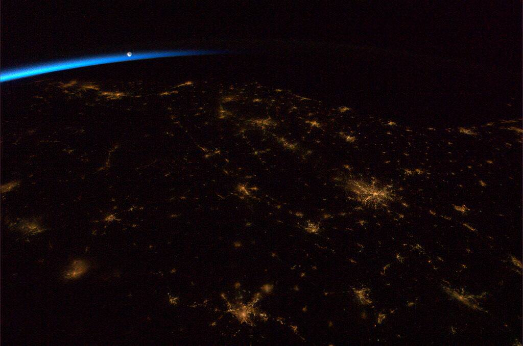
The Moon ushering in the dawn over the Southeastern United States. Credit: NASA/CSA via Chris Hadfield.

During his evening ritual of sharing images taken from the International Space Station, Commander Chris Hadfield posted this gem: a gorgeous night-time view of the southeastern United States, with the Moon hovering over Earth’s limb and the terminator separating night from day. Dawn is just beginning to break to the east, as the ISS flies overhead.

This image reflects the ‘wistful’ feelings Hadfield is having as his time in space in coming to a close. He and his two crewmates Tom Marshburn and Roman Romanenko will head back to Earth on May 13.

During a recent linkup with students, Hadfield said he is becoming “wistful” as he does tasks aboard the ISS, realizing he is doing some for the last time. He is trying to spending as much of his free time gazing out the window at Earth “because of the magnificent rarity of it and my desire to absorb as much of it as I possibly can.”

Hadfield said his emotions go between feelings of great responsibility and great honor to have been asked to command the space station, and he wants to “do it right,” making the most of his experience and communicating to as many people as possible on Earth.

“You do feel the responsibility of it to try and do it right, to try and have one perfect day on the station where I don’t make even one little mistake in any of the procedures, and I haven’t done it yet,” Hadfield admitted. “I’ve been here 130 days and I have yet to have day where I haven’t made at least one little small mistake.”

Some aspects of returning home are enticing: seeing family and friends, and eating things that aren’t dehydrated and come in a vacuum packed bag.

“I’m looking forward to fresh food and the crunch and the snap of food of all different varieties and the smell of rich coffee and the smell of fresh bread baking — that type of thing, a more full assault of the senses when I get home,” Hadfield said.

Celebrate Earth Month with 2 New Videos from NASA

Nighttime photo of the Nile delta region taken from the ISS (NASA)

Enjoy some great views of our home planet from images taken from the orbiting Earth-observing satellites and taken by astronauts on the International Space Station. The satellites and scientists are cranking out data 24/7 to help us all better understand and sustain our home planet.

Above is a video created for Earth Month, and specifically Earth Day (April 22) from ISS imagery, and below is another video from satellite imagery. These are unique looks at the beauty and wonder of our home planet.


Some of the Best Images of Earth from Space

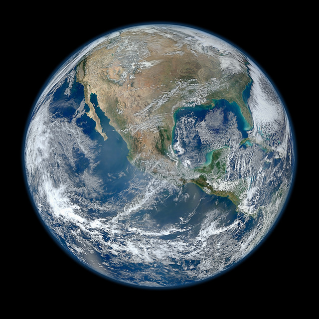
A 'Blue Marble' image of the Earth taken from the VIIRS instrument aboard NASA's most recently launched Earth-observing satellite - Suomi NPP. This composite image uses a number of swaths of the Earth's surface taken on January 4, 2012. Credit: NASA/NOAA/GSFC/Suomi NPP/VIIRS/Norman Kuring.

This video compilation from the Goddard Space Flight Center takes a look back at the best views of our planet from space in the last year, including true color satellite images, Earth science data visualizations, time lapses from the International Space Station, and computer models.

Earth Month: NASA Launches New Interactive Image Gallery

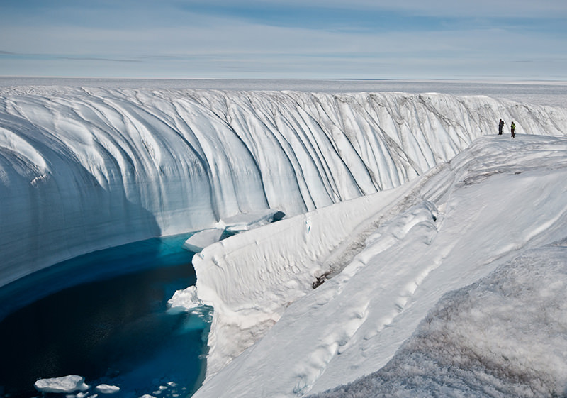
Ice sheet loss increasing at both poles. Image credit: Ian Joughin, University of Washington.

In honor of Earth month, NASA has launched a beautiful new interactive image gallery that explores and highlights our latest understanding of Earth science and our changing planet. Included are spectacular images and visualizations to help understand the latest findings.

Included is information on the decline of sea ice in the Arctic, a visualization of global aerosols, images of the latest storms, and much more.

Check out the “Earth Month 2013” website.

Weird Cloud ‘Coils’ Captured by Earth-Observing Satellite

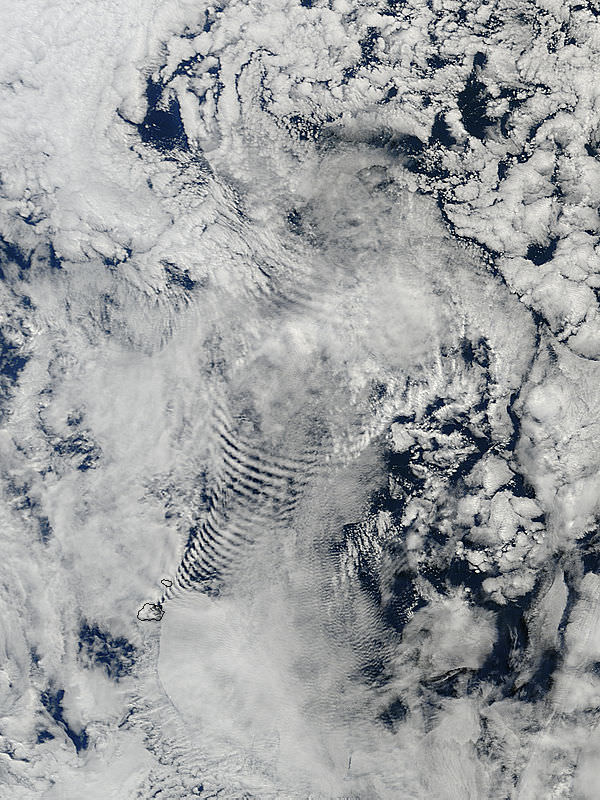
Coil-like shapes in clouds, created by their passage over the Prince Edward Islands in the south Indian Ocean. Credit: NASA/Terra/MODIS.

These are some of the strangest looking clouds I’ve seen from the fleet of Earth-observing satellites. These coil-like or bow-wave-shaped clouds were created by the clouds passing over the Prince Edward Islands, in the south Indian Ocean. It was taken by the Terra satellite with the MODIS instrument (Moderate Resolution Imaging Spectroradiometer) on March 26, 2013.

Update: Vitaliy Egorov from the Russian website allmars.net has sent us an animation of these coil clouds as seen by the Russian satellite Elektro-L:

Animation is made up of 17 frames made satellite “Electro-L” from 12:30 to 20:30 GMT March 26, 2013 at 1 frame per 30 minutes. Photo: Roscosmos / NTSOMZ / Electro-L / allmars.net.

The images are taken from a different angle than the Terra satellite. You can see more at Egorov’s website.

NASA says MODIS is playing a vital role in the development of validated, global, interactive Earth system models able to predict global change accurately enough to assist policy makers in making sound decisions concerning the protection of our environment.

‘First Light’ Image for Telescope on the International Space Station

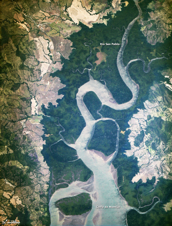
The first light from the new ISERV camera system, taken on February 16, 2013 shows the Rio San Pablo as it empties into the Golfo de Montijo in Veraguas, Panama. NASA image by Burgess Howell, SERVIR Global program.

As we reported in January, a new telescope was installed on the International Space Station – not to observe the stars, but instead look back to Earth to acquire imagery of specific areas of the world for disaster analysis and environmental studies. Called ISERV (International Space Station SERVIR Environmental Research and Visualization System), it has now taken its first image. Above is the “first light” from the new ISERV, taken at 1:44 p.m. local time on February 16, 2013.

No, this is not a giant tree trunk! It is the Rio San Pablo as it empties into the Golfo de Montijo in Veraguas, Panama.


The telescope is a modified off-the-shelf Celestron telescope, the Celestron CPC 925, a 9.25? diffraction limited Schmidt-Cassegrain telescope and if you were to buy a un-modified version, it would cost $2,500 including the mount.

The ISERV version was modified at the Marshall Space Flight Center, which is where it is controlled from, as well. It is installed in the Window Observational Research Facility (WORF) in the station’s Destiny laboratory. With a resolution down to 3.2 meters (10 feet), it will be possible to spot fairly small details and objects.

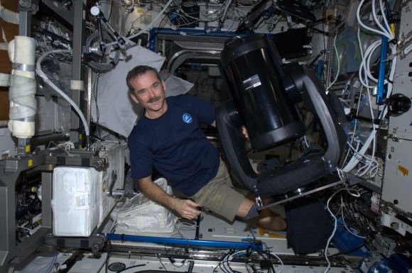
Canadian astronaut Chris Hadfield with the new ISERV (International Space Station SERVIR Environmental Research and Visualization System), a modified Celestron telescope for Earth observation. Credit: NASA/CSA

This ISERV Pathfinder is intended as an engineering exercise, with the long-term goal of developing a system for providing imagery to developing nations as they monitor natural disasters and environmental concerns.

“ISERV’s full potential is yet to be seen, but we hope it will really make a difference in people’s lives,” said principal investigator Burgess Howell of NASA’s Marshall Space Flight Center. “For example, if an earthen dam gives way in Bhutan, we want to be able to show officials where the bridge is out or where a road is washed out or a power substation is inundated. This kind of information is critical to focus and speed rescue efforts.”

The system will use on positioning software to know where the space station is at each moment and to calculate the next chance to view a particular area on the ground. If there’s a good viewing opportunity, the SERVIR team will instruct the camera to take high-resolution photographs at 3 to 7 frames per second, totaling as many as 100 images per pass.

The current mission will test the limitations of this ISERV system and identify measures for improvements in a more permanent system. For instance, the engineering team is working to determine how the geometry of the ISS window affects the imagery; how much sunlight is needed to capture clear images; and how the atmosphere affects that clarity. This characterization phase will last several weeks to a few months. Eventually, ISERV should be made available to the natural hazards community and to basic research scientists.

Source: NASA Earth Observatory