An Iceberg Caught in the Act of Forming

An airborne ‘eye in the sky’ has provided unprecedented views and details of a massive iceberg calving from its parent glacier in Antarctica. Essentially, we’re able to watch the process of an iceberg being born. NASA’s Operation IceBridge mission discovered a huge crack in the Pine Island Glacier in western Antarctica. The mammoth rift extends at least 18 miles and is 50 meters deep, and scientists say it could produce an iceberg more than 800 square kilometers in size.

“We are actually now witnessing how it happens and it’s very exciting for us,” said IceBridge project scientist Michael Studinger, Goddard Space Flight Center, Greenbelt, Md. “It’s part of a natural process but it’s pretty exciting to be here and actually observe it while it happens. To my knowledge, no one has flown a lidar instrument over an actively developing rift such as this.”
Continue reading “An Iceberg Caught in the Act of Forming”

Satellite Image of the ‘Snowtober’ Storm

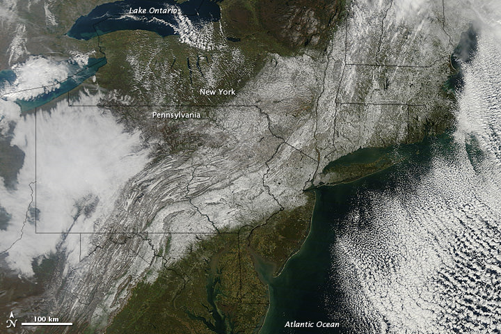
The 'Snowtober' storm in the Northeastern US, as seen by the The Moderate Resolution Imaging Spectroradiometer (MODIS) on NASA’s Terra satellite. Credit: NASA

[/caption]

An unusual October storm dumped wet heavy snow across much of the Northeast US over the weekend, as much as 32 inches (81 centimeters) in some areas. Nicknamed “Snowtober,” the storm left as many as 3 million people without power at the snowstorm’s peak, and was blamed for the deaths of at least 10 people. In this images from the Moderate Resolution Imaging Spectroradiometer (MODIS) on NASA’s Terra satellite, a swath of snow sweeps from West Virginia northeastward to Maine, as seen on Oct. 30, 2011. Clouds hover east and west of the snow, blocking the satellite sensor’s view of western Pennsylvania and parts of the Atlantic Ocean.

The storm broke snowfall-total records in many cities, with strong winds and heavy tree damage as the heavy snow easily clung to trees which still had their leaves, snapping branches and power lines.

Source: NASA Earth Obseratory

NASA’s New Climate and Weather Satellite Launches

The National Polar-orbiting Operational Environmental Satellite System Preparatory Project, or NPP, launched successfully on a Delta 2 rocket early today at at 5:48 a.m. EDT 09:48 GMT (or precisely at 2:48:01.828 a.m. PDT, according to NASA’s Twitter feed). The next generation satellite will measure both global climate changes and key weather variables, as well as test new technologies for future Earth observing satellites.

The spacecraft has also successfully separated and is now in orbit. The separation video is below.

Continue reading “NASA’s New Climate and Weather Satellite Launches”

Next Generation Climate and Weather Satellite Ready for Friday Launch

A new satellite that will test key technologies and instruments for the next generation of climate and weather-monitoring satellites is scheduled to launch on Friday, Oct. 28, 2011. The NPOESS Preparatory Project (NPP) mission has a planned liftoff from Vandenberg Air Force Base in California at 5:48 a.m. EDT/2:48 a.m. PDT.

“This is the first mission designed to provide observations for both weather forecasters and climate researchers and will provide data that is critical to climate research,” said Jim Gleason, NPP project scientist during a news briefing last week.
Continue reading “Next Generation Climate and Weather Satellite Ready for Friday Launch”

As the World Burns: Satellites Watch Fires Around the World

NASA put out this video last week and we missed covering it, but this is a very interesting little video that takes you on a narrated global tour of tens of millions of fires detected from space between July 2002 and July 2011. Yes, that’s right, tens of millions of fires on Earth, and these aren’t tiny little campfires — they are big enough to be seen from space. The video was created from new satellite data visualizations, and is combined with satellite views of vegetation and snow cover to show how fires relate to seasonal changes. The research helps scientists understand how fire affects our environment on local, regional and global scales.
Continue reading “As the World Burns: Satellites Watch Fires Around the World”

Awesome Pic: Astronaut Ron Garan’s Window to the World

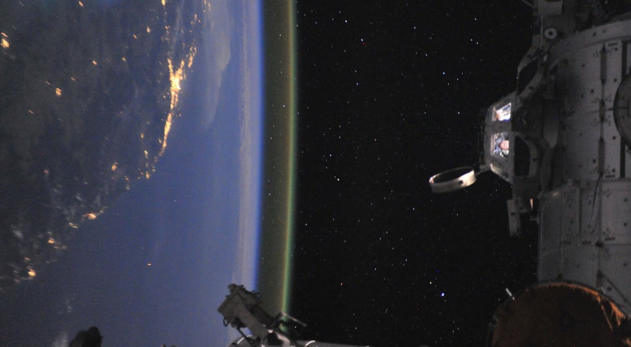
Astronaut Ron Garan in the cupola of the International Space Station off the coast of Australia. Credit: NASA

[/caption]

This has become my new favorite space photo! Look closely into the windows of the Cupola on the International Space Station: That’s astronaut Ron Garan, on September 16, 2011, his last day on board the space station. “That’s me in the cupola of the International Space Station off the coast of Australia taking my last of over 25,000 pics that I still want to share with everyone,” Garan wrote on his Google+ page. Not only are the colors and view spectacular, but this has got to be one of the best destination photos ever — not to mention a priceless keepsake and memento for Garan from his expedition on the ISS.

You can see some of the thousands of images Garan took from space on his Twitpic page.

It Turns Out Some Borders *Are* Visible from Space

This picture shows the illuminated man-made border between India and Pakistan,the line snaking through the landscape, as seen from the International Space Station on August 21, 2011. Of the hundreds of clusters lights, the largest are the capital cities of Islamabad, Pakistan, and New Delhi, India. Credit: NASA/Ron Garan

[/caption]

There is an oft-repeated and perhaps beautiful saying that you can’t see political borders from space. Well, it turns out that saying isn’t true; not anymore. ISS astronaut Ron Garan took this image recently which clearly shows the border between India and Pakistan. Since 2003, India has illuminated the border with Pakistan by floodlights in attempt to prevent ammunition trafficking and the infiltration of terrorists.

“Since the beginning of human spaceflight fifty years ago, astronauts have reflected on how peaceful, beautiful, and fragile the Earth looks from space,” Garan wrote on his Fragile Oasis blog. “These reflections are not clichés that astronauts say because it feels good. It is truly moving to look at the Earth from space.”

But seeing this clearly visible political border was sobering for Garan and his crewmates.

“Realizing what this picture depicted had a big impact on me,” he said. “When viewed from space, Earth almost always looks beautiful and peaceful. However, this picture is an example of man-made changes to the landscape in response to a threat, clearly visible from space. This was a big surprise to me.”

Garan added, however, that the point here is not that we can look down at the Earth and see a man-made border between India and Pakistan. “The point is that we can look down at that same area and feel empathy for the struggles that all people face,” he said. “We can look down and realize that we are all riding through the Universe together on this spaceship we call Earth, that we are all interconnected, that we are all in this together, that we are all family.”

Garan said he believes our world is a place where possibilities are limited only by our imagination and our will to act. “It is within our power to eliminate the suffering and poverty that exist on our planet,” he said.

Read more on Fragile Oasis.

The View from Space: Northwestern Europe at Night

Northwestern Europe at night, as seen from the International Space Station on August 10, 2011. Credit: NASA

[/caption]

Astronauts always say the view of Earth is the best part of being in space. Here’s a beautiful shot of northwestern Europe at night. The landscape is dotted with clusters of lights from individual urban areas; visible are London, Paris, Brussels, Milan and Amsterdam, which stand out due to their large light “footprints,” while the English Channel is completely dark.

This photograph was taken by one of the Expedition 28 crewmembers on the International Space Station (ISS) and was taken with a short camera lens, providing the wide field of view. To give a sense of scale, the centers of the London and Paris metropolitan areas are approximately 340 kilometers (210 miles) from each other.

Source: NASA Earth Observatory website

Latest Satellite Images/Videos as Hurricane Irene Bears Down on US East Coast

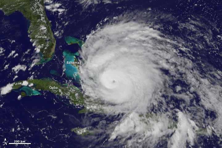
GOES satellite image of Hurricane Irene as of 18:15 UTC on August 26, 2011. Credit: NOAA

What a view: Here’s a video of Hurricane Irene’s path, starting on August 24 up until 18:40 UTC on August 26, 2011, as seen by a GOES satellite. Even though Hurricane Irene is continuing to slowly weaken as it pushes closer to the Carolina coast, this massive storm could affect a huge area of the Eastern US seaboard, and tropical storm force winds and squalls are buffeting the coast. Irene will impact the entire Mid-Atlantic and Northeast Coast, including Washington, Philadelphia, New York City, Hartford, Ct. and Boston this weekend.

This hurricane spans nearly 1,000 kilometers (600 miles).

Below is a video taken from the International Space Station late yesterday afternoon. Includes astronaut commentary on the view of this “huge, scary storm” from 370 km (230 miles) up:

Or click on this link to see the latest video of Hurricane Irene from GOES and Goddard Space Flight Center

Cameras mounted on the International Space Station captured this video. Forecasters are predicting landfall on the outer banks of North Carolina Saturday before tracking up the mid-Atlantic states and a possible path over the metropolitan New York area and New England late this weekend.

[/caption]

Hot off the wires is this satellite image of Hurricane Irene taken less than an hour ago (as of this writing) by one of the GOES satellites for NOAA.

Here’s the latest from WeatherBug:

Imagery of Hurrican Irene from WeatherBug.com

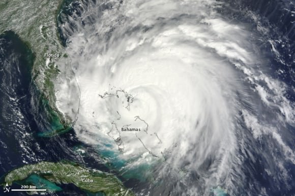
And here’s the latest from the Moderate Resolution Imaging Spectroradiometer (MODIS) on the Terra satellite on August 25:

Hurricane Irene as seen by Moderate Resolution Imaging Spectroradiometer (MODIS) on the Terra satellite on August 25. Credit: NASA

See more up-to-date satellite images from NOAA’s cadre of Earth-observing satellites at this link.

Sources: NASA Earth Observatory, WeatherBug, NOAA, Goddard Space Flight Center

More Views of Hurricane Irene from Space: It’s Big

A view of Hurricane Irene taken by the GOES satellite at 2:55 p.m. Eastern Daylight Time on August 24, 2011. Credit: NASA

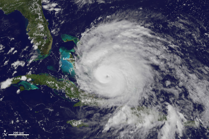
Here are several different views of Hurricane Irene: from 230 miles above the Earth, cameras on the International Space Station captured several views of powerful Hurricane Irene as it churned over the Bahamas at 3:10 p.m. EDT on August 24, 2011. Irene is moving to the northwest as a Category 3 hurricane, packing winds of 120 miles an hour. Irene is expected to strengthen to a Category 4 storm as it heads toward the Outer Banks of North Carolina, the Eastern Seaboard and the middle Atlantic and New England states.

See more from other satellites, below:

[/caption]

This view of Irene was taken by the GOES satellite at 2:55 p.m. Eastern Daylight Time on August 24, 2011. Irene now has a distinct eye and the clouds spiraling around the center are becoming more compact. The image also shows how large Irene has become, measuring several hundred kilometers across.

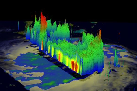
A three dimensional perspective of Irene, showing rainfall. Credit: NASA/TRMM satellite

This image was taken on August 22, but is a really nifty, three-dimensional view of the precipitation from Irene, as seen by the Tropical Rainfall Measuring Mission. It reveals an area of deep convection (shown in red) near the storm’s center where precipitation-sized particles are being carried aloft. These tall towers are associated with strong thunderstorms responsible for the area of intense rain near the center of Irene seen in the previous image. They can be a precursor to strengthening as they indicate areas within a storm where vast amounts of heat are being released. This heating, known as latent heating, is what is drives a storm’s circulation and intensification.

Here’s the latest view of Irene from WeatherBug:

View of Irene from WeatherBug.com

As of 8 a.m. EDT on August 25, Hurricane Irene was located near 25.5 N and 76.5 W, or 65 miles east-southeast of Nassau, Bahamas. This places it about 670 miles south of Cape Hatteras, N.C. Irene`s top sustained winds remain at 115 mph, and is moving to the northwest at 13 mph.

Sources: NASA Multimedia,