Maps of Earthquake and Aftershocks in Haiti

Caption: NASA Earth Observatory image by Jesse Allen

At 21:53 UTC on January 12, 2010 an earthquake with a magnitude 7.0 struck the Caribbean nation of Haiti. The US Geological Survey (USGS) says that it was the most violent earthquake to strike the impoverished country in a century, and death tolls are reported to be rising into the hundreds of thousands. “Porte-au-Prince is probably one of the worst constructed cities in the world, and even the presidential palace collapsed,” said Roger Bilham, from the University of Colorado-Boulder. “This is an earthquake many of us were expecting to occur sooner or later.”

Map of earthquake and aftershocks in Haiti. Credit: USGS

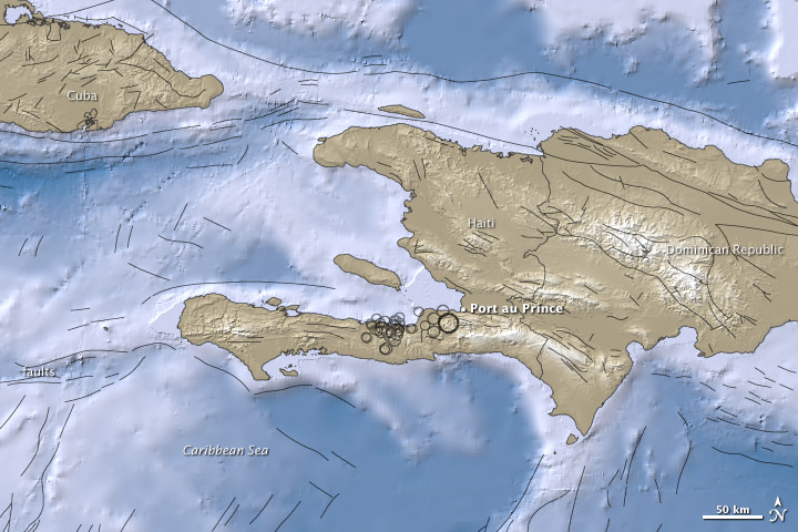
This image from the USGS shows all the seismic activity in the region, including areas in the ocean.

Dennis Mileti, also from CU-Boulder said three factors contributed to the severity of the Haitian event: the shallow location of the earth quake (only 8.3 kilometers or 5.2 miles underground) resulting in high shaking intensity; the low-quality construction of structures in the area; and the lack of earthquake preparedness and increased vulnerability resulting from Haiti being a poor country.

The epicenter of the earthquake was just 15 kilometers (10 miles) southwest of the Haitian capital of Port-au-Prince. Besides its strong magnitude, the earthquake’s shallow depth ensured that the densely populated capital would suffer violent shaking. More than 30 aftershocks rocked the area.

Reports say a majority if the infrastructure has collapsed, including schools, hospitals, government buildings – such as the presidential palace and the main prison — aid centers, and shantytowns.

The top map shows the region surrounding the 7.0-magnitude earthquake and the aftershock. Earthquake magnitudes are measures of earthquake size calculated from ground motion recorded on seismographs.

Ocean areas appear in shades of blue, and land areas appear in shades of brown. Both in water and on land, higher elevation appears in lighter colors. Black circles mark earthquake locations determined by the USGS, and circle sizes correspond with quake magnitudes. Black lines indicate fault lines.

The map was created using earthquake and plate tectonics data from the USGS Earthquake Hazard Program, elevation data from the Shuttle Radar Topography Mission (SRTM) courtesy of the University of Maryland’s Global Land Cover Facility, and ocean bathymetry data from the British Oceanogprahic Data Centre’s (BODC) General Bathymetric Chart of the Oceans (GEBCO).


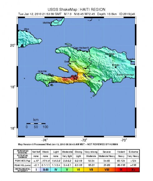
This “shake” map from the USGS shows the intensity of shaking felt across the region in Haiti.

The USGS said the earthquakes occurred along the boundary between the Caribbean and North America plates. This area is characterized as a strike-slip fault where the Caribbean plate moves eastward with respect to the North America plate.

But Haiti wasn’t the only place an earthquake has taken place recently. Check out this intriguing map of earthquakes in the past week.

Sources: NASA Earth Observatory, USGS, University of Colorado-Boulder, Nature,

UK’s Big Snowfall, As Seen From Space

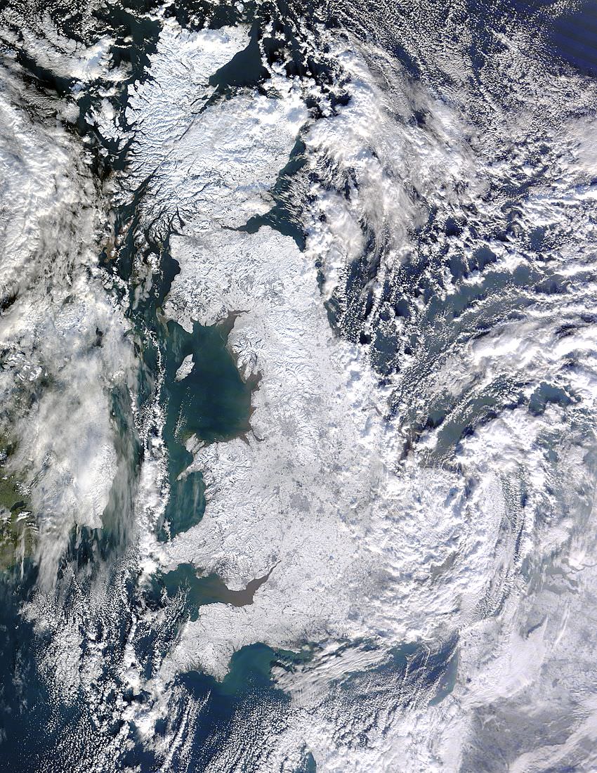
Great Britain, as seen on Jan. 7, 2010 by the Terra Satellies. Credit: NASA

[/caption]
This satellite image taken by NASA’s Terra satellite shows the entire island of Great Britain blanketed by heavy snowfall, with some areas seeing the most snow in 50 years. It looks pretty from space, but frigid temperatures followed snowfall, leaving roads and sidewalks treacherously icy, according to news reports. As of January 7, overnight temperatures had plunged to -18 degrees Celsius (-0.4 degrees Fahrenheit) in isolated spots, with more widespread temperatures of -10 degrees Celsius (14 degrees Fahrenheit). The heavy snowfall downed power lines, leaving several thousand homes in southern England without electricity.

North America is also experiencing heavy snows and cold temperatures. NASA’s Earth Observatory website says that a possible contributor to the persistent cold and snow across much of the Northern Hemisphere’s mid-latitudes in December 2009 and January 2010 could be the fact that the atmosphere was in an extreme negative phase of the Arctic Oscillation (AO). The AO is a seesawing strengthening and weakening of semi-permanent areas of low and high atmospheric pressure in the Arctic and the mid-latitudes. One consequence of the oscillation’s negative phase is cold, snowy weather in Eurasia and North America during the winter months. The extreme negative dip of the Arctic Oscillation Index in December 2009 was the lowest monthly value observed for the past six decades.

Source: Earth Observatory

Mayon Volcano Threatens Major Eruption

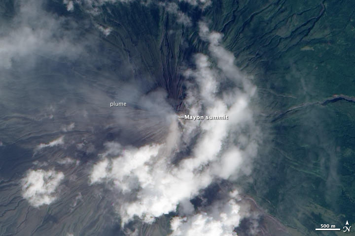
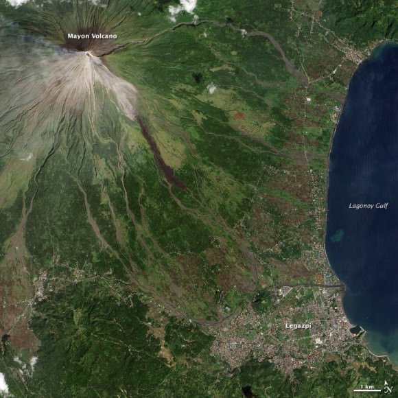
Satellite image of Mayon Volcano in the Phillipines from Dec. 28, 2009.

[/caption]
Mayon Volcano, on the Philippine island of Luzon, has been exhibiting activity suggesting a major eruption is imminent. Described as an “intense level of unrest” by the Philippine Institute of Volcanology and Seismology, Mayon exhibited 7 ash explosions, dozens of earthquakes related to the movement of magma beneath the volcano, over 100 rock falls from the summit, and 3 active lava flows. The Philippine government is enforcing evacuations in a danger zone extending 7 kilometers (4 miles) north and 8 kilometers (5 miles) south of the summit. Tens of thousands of people living within the danger zone (up to 8 kilometers away) of Mayon Volcano in the Philippines were forced to evacuate to emergency shelters in mid-December 2009.

The satellite image above shows Mayon emitting a thin volcanic plume on Dec. 28. Ash obscures the summit crater and clouds hide lava flows on the volcano’s flanks. The natural-color image was acquired by the Advanced Land Imager (ALI) aboard the NASA Earth Observing-1 (EO-1) satellite.

Below, the image from Dec. 15 shows how close a major populated area is to the volcano.

Mayon Volcano on Dec. 15, 2009.

The volcano has been noticeably active for several weeks, and officials say “magma is close to the crater and hazardous explosive eruption is imminent.”

Source: NASA Earth Observatory

Record Setting US Snowstorm as Seen From Space

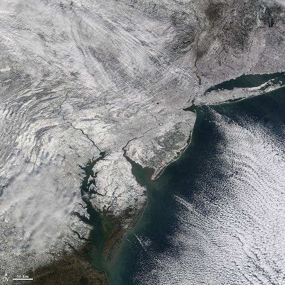
A record-setting snowstorm that blanketed the US Atlantic coast snarled both road and air traffic as holiday travelers and shoppers were forced to stay home. In all, the National Climatic Data Center (NCDC) reported 66 daily snow records in the northeastern United States were tied or broken over the weekend. Additionally, 21 monthly snow total records were tied or broken. Snowfall totals from 30 – 60 cm (1 to 2 feet) were commonplace.

This image from the Moderate Resolution Imaging Spectroradiometer (MODIS) on NASA’s Terra satellite shows the Chesapeake Bay area cloaked in white on December 21, 2009, the first day of northern hemisphere winter. The winter solstice occurred Monday at 16:47 GMT (11:47 am EST). Learn more about the solstice on today’s 365 Days of Astronomy podcast, “December Solstice, Celebrating the Light” by Dr. Judith Young.

The image above encompasses about 480 km (300 miles) lengthwise. The two big rivers near the center are the Susquehanna (north) and Potomac rivers, which flow into the Chesapeake Bay. Washington, D.C., sits alongside the Potomac, just north of the river’s hook-shaped curve. The inlet to the north is Delaware Bay.

Source: NASA’s Earth Observatory

Giant Iceberg Still Heading for Australia (Satellite Images)

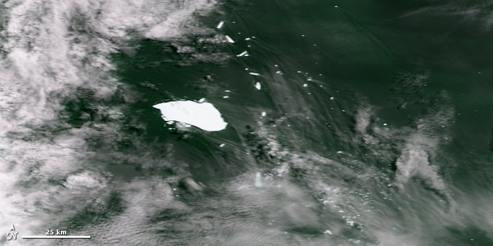
Iceberg B17-B Adrift Off the Southwestern Coast of Australia as seen on Dec. 11, 2009. Credit: NASA Earth Observatory

A city-sized iceberg that has been making its way towards Australia’s southwestern coast is now breaking up into hundreds of smaller icebergs as it drifts into warmer waters. This is creating potentially hazardous conditions for ships trying to navigate the region. The iceberg, known as B17B, was spotted last week on satellite imaging about 1,100 miles (1,700 kilometers) off Western Australia state, prompting Australia’s Bureau of Meteorology to issue a shipping alert. When first observed, B17B was a whopping 140 square kilometers (54 square miles). Now, it is about 115 square kilometers (44 square miles), or around 18 kilometers (11 miles) long and 8 kilometers (5 miles) wide, said glaciologist Neal Young of the Australian Antarctic Division. Still, that is one huge iceberg.

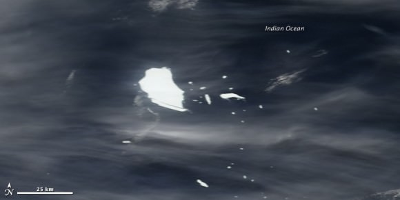
Iceberg B17-B Adrift Off the Southwestern Coast of Australia  as seen on Nov. 29, 2009. Credit: NASA Earth Observatory
Iceberg B17-B Adrift Off the Southwestern Coast of Australia as seen on Nov. 29, 2009. Credit: NASA Earth Observatory

B17B has broken up into hundreds of smaller icebergs, some up to several kilometers wide, and spread over more than 1,000 kilometers of ocean. Young said he expects it to dissipate, but is unsure when that will happen.

The iceberg is one of several that split off in Antarctica in 2000 when parts of two major ice shelves — the Ross Sea Ice Shelf and Ronne Ice Shelf — fractured.

Icebergs frequently split or “calve” off Antarctica’s ice shelves, and they often get swept up in strong circumpolar currents that carry them around the icy continent. Occasionally icebergs drift northward, out of the continent’s orbit. Only rarely, however, do icebergs drift as far north as Australia without melting, which is why scientists were surprised to spot this especially gigantic iceberg in its current location.

Sources: NASA Earth Observatory, AP

Here are some cool iceberg pictures.

Google Satellite

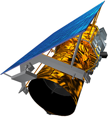
If you’ve spent any time on the internet, you’ve probably had a chance to use either Google Earth or Google Maps. Both of these tools allow you to see a satellite view of the Earth, and zoom right in to see your home from space. But is there a Google satellite to take these photographs?

Google doesn’t actually have a satellite of their own. Instead, they use images from a variety of sources and store them on their servers. These images come from NASA satellites, USGS aerial surveys, and satellite photos from commercial operators. Google has an exclusive contract with a company called GeoEye, which recently launched their GeoEye-1 satellite. This commercial satellite blasted off on September 6, 2008, and is capable of resolving images on the Earth down to a size of 0.41 meters.

So how can you use these images? The easiest tool to use is Google Maps. This is a web-based tool that lets you browse around satellite photos of the Earth. You can zoom in and out, and type in a specific address anywhere on Earth to go right there. It also has driving directions, and all kinds of features that you can turn on and off to give you more information – like local sightseeing highlights.

The other tool that Google has created is called Google Earth. Unlike Google Maps, you actually need to download Google Earth to your local computer; PC, Mac, Linux, and even on your iPhone. Once you have the application installed, you see a 3-D version of the Earth that you can spin around, zoom in and out. You can zero in to any spot on Earth and see the highest resolution images they have available. There’s also a big community of developers who have created additional views that you can install. This lets you see additional photographs, contour maps, etc.

We have written many articles about Google satellite views. Here’s an article about how Google’s satellite had a bird’s eye view of the Obama Inauguration, and here’s a tool for Google Earth that lets you track satellite debris.

We’ve also recorded several episodes of Astronomy Cast about satellites. Listen here, Episode 100: Rockets.

Get a $36 Million World Map for Free

When the first Landsat Earth-observing satellite launched in 1972, virtually every piece of technology that we think of as essential for viewing, sharing, or analyzing digital images — like the internet or DVD’s — either hadn’t been invented or commercialized, like the microprocessors that run desktop computers. “It cost about $4,000 for a single Landsat image, and it takes about 9,000 of them to map the land area of the globe,” said Jeff Masek, from NASA. “To make a global image for just one time period would have cost $36 million.” But now, in this age where everything is digital and it’s easy to exchange information, anyone can download Landsat images for free. Recently, NASA and the U.S. Geological Survey put the finishing touches on a new collection of mapped images covering the entire land surface of the Earth. However, if you want the entire full-size version, it would be as big as the Hoover Dam.

This collaboration between NASA, the U.S. Geological Survey, and the U.S. National Geospatial Agency, the Global Land Survey 2005 features around 9,500 images from NASA’s Landsat satellites captured between 2004–2007.

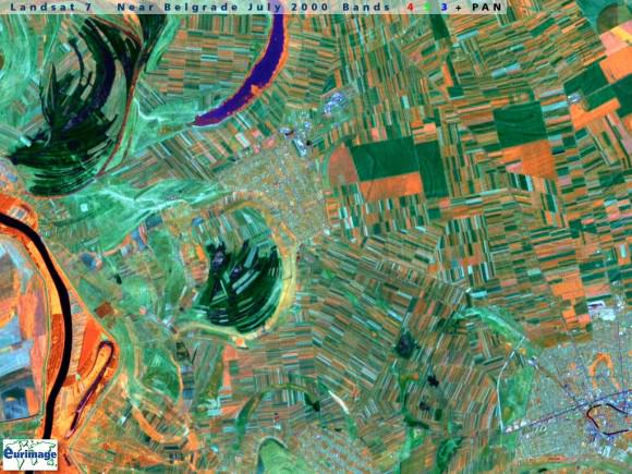
A Landsat image that could be artwork.

The images are detailed enough to make out features as small as 30 meters (about one-third the length of an American football field), they have been carefully screened for clouds, and each one shows the landscape during its growing season.

Some of the images are as striking as a piece of artwork. Stitched together into a single mosaic, the collection paints the most detailed picture of Earth’s land surface a person can get for free.

For more information see these two Landsat sites:

http://landsat.gsfc.nasa.gov/

http://www.landsat.org/

Source: NASA Earth Observatory

Crescent Earth as Seen by Comet Chasing Spacecraft

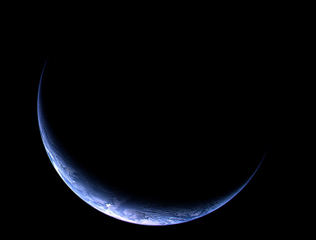
Earth as seen by the Osiris camera on Rosetta. Credit: ESA

Title this one “Rich Blue Crescent” (as opposed to Pale Blue Dot.) This spectacular image of our home planet was captured by the OSIRIS instrument on ESA’s Rosetta comet chaser today (November 12) at 12:28 GMT from about 633,000 km as the spacecraft approached Earth for the third and final swingby. Closest approach is due at 07:45 GMT, on November 13. You can follow Rosetta’s progress at ESA’s Rosetta site and the Rosetta Blog.

Satellite Map

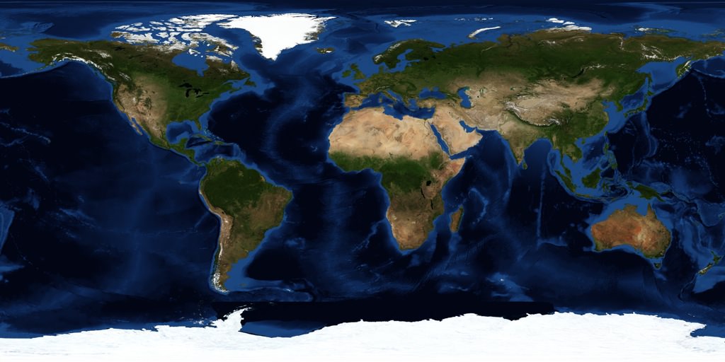
NASA satellite map of the Earth

[/caption]
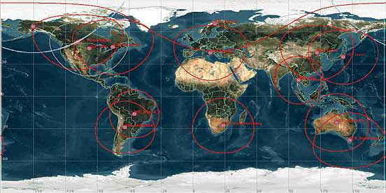
There are thousands of satellites overhead in space right now, and many of them are being used to map every single square meter of planet Earth. And many of these images are being freely distributed on the Internet so you can access them through any browser. If you’re looking for a satellite map, there are many services out there that can help you out.

Probably the easiest and best place to start is with the Google Maps service from Google. This allows you to see a satellite map of the entire Earth. You can drag around the map to browse around the planet, and you can zoom out and in right down to the highest resolution images they have in their server. In many cases this means you can see your house, your yard, and even your car parked out in the street. You can also type in a specific address location and go straight there. There are street maps you can overlay or remove, you can get driving directions, and much more. And the Google Maps API has been made available by Google to other websites, so people are developing mashups that let you track running routes and find the nearest bathroom.

An even cooler satellite mapping service is Google Earth. Unlike Google Maps, you have to download Google Earth to your local PC, Mac or Linux machine (there’s even an iPhone version). Then you get this cool spinning 3-D version of the Earth. You can zoom out and in, type in a specific location address or geocode to find any spot on Earth. They also have a big library of additional layers that you can put over top, to see additional information mapped on the Earth. It’s well worth the download.

Another good service is TerraServer; they let you buy satellite maps if you want a nice printed version for your wall. If you don’t want to use Google, there are similar mapping tools from Microsoft and Yahoo.

We have written many articles about how satellites are being used to map the Earth. Here’s an article about how scientists use satellite photos to track penguin poop from space, and how Google’s maps had a satellite view of Obama’s inauguration.

We have also recorded an episode of Astronomy Cast all about Earth. Listen here, Episode 51: Planet Earth.

Arctic Sea Ice Extent is Third Lowest on Record

U.S. satellite measurements show Arctic sea ice extent in 2009 – the area of the Arctic Ocean covered by floating ice – was the third lowest since satellite measurements were first made in 1979. While the ice area at minimum was an increase from the past two years, it is still well below the average for the past 30 years. In the video above, Tom Wagner, NASA’s cryosphere program manager, describes the shrinking of Arctic sea ice and the significance of the problem for the rest of the planet.
Continue reading “Arctic Sea Ice Extent is Third Lowest on Record”