NASA Launches Revolutionary Earth Science Satellite Measuring Soil Moisture Cycle

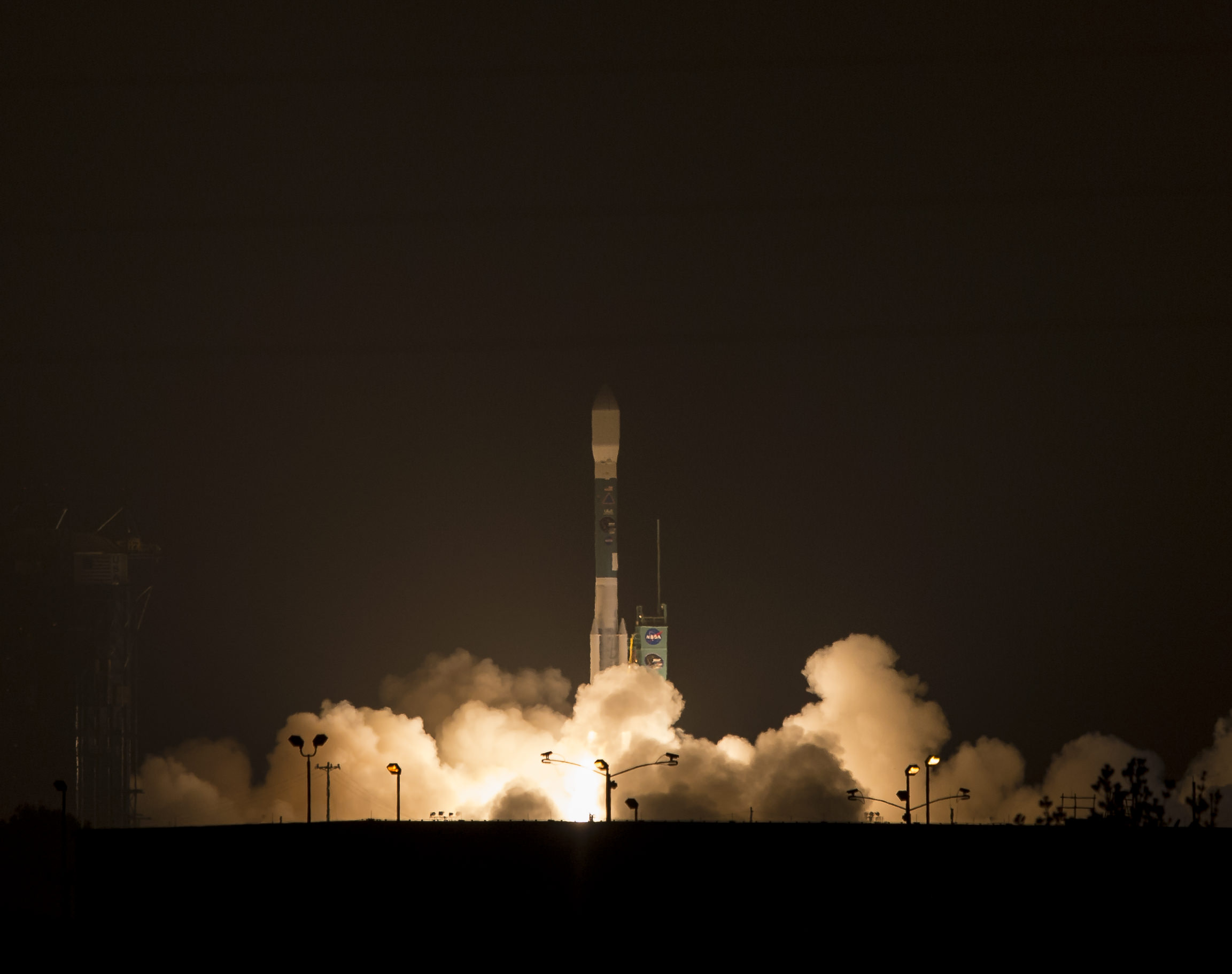
NASA's Soil Moisture Active Passive (SMAP) observatory, on a United Launch Alliance Delta II rocket, is seen after the mobile service tower was rolled back Friday, Jan. 30 at Space Launch Complex 2, Vandenberg Air Force Base, Calif. Image Credit: NASA/Bill Ingalls

NASA’s Soil Moisture Active Passive (SMAP) observatory, on a United Launch Alliance Delta II rocket, is seen after the mobile service tower was rolled back Friday, Jan. 30 at Space Launch Complex 2, Vandenberg Air Force Base, Calif.
Image Credit: NASA/Bill Ingalls
Story updated[/caption]

At dawn this morning (Jan. 31) NASA launched an advanced Earth science satellite aimed at making measurements of our planet’s surface soil moisture and freeze/thaw states from space that will revolutionize our understanding of the water, energy, and carbon cycles driving all life on Earth, aid weather forecasting and improve climate change models.

NASA’s new Soil Moisture Active Passive (SMAP) observatory thundered off the pad at 6:22 a.m. PST (9:22 a.m. EST) Saturday atop a two stage United Launch Alliance Delta II rocket from Space Launch Complex 2 on Vandenberg Air Force Base, California.

The $916 million satellite successfully separated from the rocket’s second stage some 57 minutes after the flawless liftoff and was injected into an initial 411- by 425-mile (661- by 685-kilometer) orbit. The spacecraft then deployed its solar arrays and telemetry indicated it was in excellent health.

“We’re in contact with SMAP and everything looks good right now,” NASA Launch Manager Tim Dunn said.

“Deployment of the solar arrays is underway. We just couldn’t be happier.”

SMAP separated from the second stage while pointed toward the sun as seen in the video below from a rocket mounted camera:

Video Caption: A camera on the second stage of the Delta II rocket captured this footage as the SMAP spacecraft pushed itself away from the rocket to complete the delivery of the Earth-observing spacecraft to its proper orbit following Jan. 31, 2015 liftoff. Credit: NASA TV/ULA

SMAP is NASA’s 1st Earth observing satellite designed to make high resolution global observations of Earth’s vital surface soil moisture content and freeze/thaw cycle just below your feet. It will aid global forecasting and have broad applications for science and society.

SMAP’s combined radar and radiometer instruments will peer into the top 2 inches (5 centimeters) of soil, through clouds and moderate vegetation cover, day and night, to produce the highest-resolution, most accurate soil moisture maps ever obtained from space, says NASA.

The blastoff of SMAP successfully concluded NASA’s ambitious plans to launch a record breaking total of five Earth science satellites in less than a year’s time.

“The launch of SMAP completes an ambitious 11-month period for NASA that has seen the launch of five new Earth-observing space missions to help us better understand our changing planet,” said NASA Administrator Charles Bolden.

“Scientists and policymakers will use SMAP data to track water movement around our planet and make more informed decisions in critical areas like agriculture and water resources.”
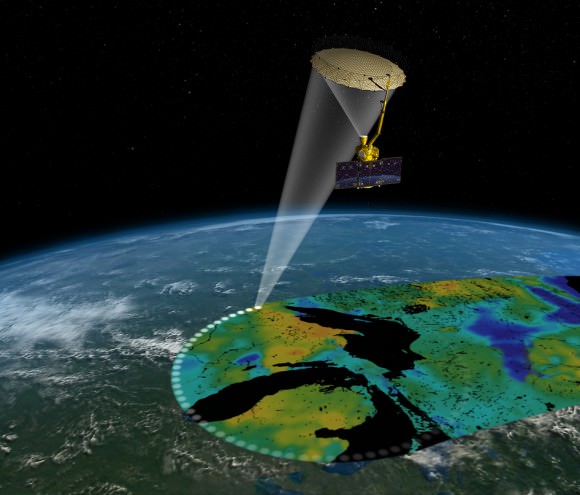
Artist's rendering of the Soil Moisture Active Passive satellite. The width of the region scanned on Earth’s surface during each orbit is about 620 miles (1,000 kilometers).  Image credit: NASA/JPL-Caltech
Artist’s rendering of the Soil Moisture Active Passive satellite. The width of the region scanned on Earth’s surface during each orbit is about 620 miles (1,000 kilometers). Image credit: NASA/JPL-Caltech

SMAP is projected to last for at least a three year primary mission.

The prior NASA Earth science instrument launched was the Cloud Aerosol Transport System (CATS) payload hauled to space by the SpaceX CRS-4 Dragon on Jan. 10, 2015 and recently installed on the exterior of the ISS. Read my CATS installation story – here.

The three earlier NASA Earth science missions launched over the past year included ISS-RapidScat in September 2014, the Global Precipitation Measurement (GPM) Core Observatory, a joint mission with the Japan Aerospace Exploration Agency, in February 2014, and the Orbiting Carbon Observatory-2 (OCO-2) carbon observatory in July 2014.

“Congratulations to the NASA Launch Services Program team, JPL and all of our mission partners on today’s successful launch of the SMAP satellite,” said Jim Sponnick, ULA vice president, Atlas and Delta Programs.

“It is our honor to launch this important Earth science mission to help scientists observe and predict natural hazards, and improve our understanding of Earth’s water, energy and carbon cycles.”

SMAP will provide high-resolution, space-based measurements of soil moisture and its state — frozen or thawed — a new capability that will allow scientists to better predict natural hazards of extreme weather, climate change, floods and droughts, and help reduce uncertainties in our understanding of Earth’s water, energy and carbon cycles, according to a NASA description.

The mission will map the entire globe every two to three days for at least three years and provide the most accurate and highest-resolution maps of soil moisture ever obtained. The spacecraft’s final circular polar orbit will be 426 miles (685 kilometers), at an inclination of 98.1 degrees. The spacecraft will orbit Earth once every 98.5 minutes and repeat the same ground track every eight days.

“All subsystems are being powered on and checked out as planned,” Kent Kellogg, the SMAP project manager, during a post-launch press conference.

“Communications, guidance and control, computers and power are all operating nominally.”

The observatory is in excellent health. Its instruments will be turned on in 11 days.

Today’s blastoff of SMAP marks ULA’s second successful launch this month as well as the second of 13 planned for 2015. ULA’s first launch of 2015 was MUOS-3 from Cape Canaveral on Jan. 20.

ULA’s next launch involves NASA’s Magnetospheric Multiscale Mission (MMS) to study Earth’s magnetic reconnection. It is scheduled for launch on an Atlas V 421 booster on March 12 from Cape Canaveral. See my up close visit with MMS and NASA Administrator Charles Bolden at NASA Goddard Space Flight Center detailed in my story – here.

Stay tuned here for Ken’s continuing Earth and planetary science and human spaceflight news.

Ken Kremer

What Is the Longest River In The World?

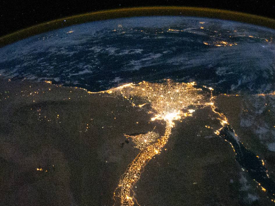
The Nile River and Delta, viewed at night by the Expedition 25 crew on Oct. 28, 2010. Credit: NASA

Planet Earth boasts some very long rivers, all of which have long and honored histories. The Amazon, Mississippi, Euphrates, Yangtze, and Nile have all played huge roles in the rise and evolution of human societies. Rivers like the Danube, Seine, Volga and Thames are intrinsic to the character of some of our most major cities.

But when it comes to the title of which river is longest, the Nile takes top billing. At 6,583 km (4,258 miles) long, and draining in an area of 3,349,000 square kilometers, it is the longest river in the world, and even the longest river in the Solar System. It crosses international boundaries, its water is shared by 11 African nations, and it is responsible for the one of the greatest and longest-lasting civilizations in the world.

Officially, the Nile begins at Lake Victoria – Africa’s largest Great Lake that occupies the border region between Tanzania, Uganda and Kenya – and ends in a large delta and empties into the Mediterranean Sea. However, the great river also has many tributaries, the greatest of which are the Blue Nile and White Nile rivers.

The White Nile is the source of the majority of the Nile’s water and fertile soil, and originates from Africa’s Great Lakes region of Central Africa (a group that includes Lake Victoria, Edward, Tanganyika, etc.). The Blue Nile starts at Lake Tana in Ethiopia, and flows north-west to where it meets the Nile near Khartoum, Sudan.

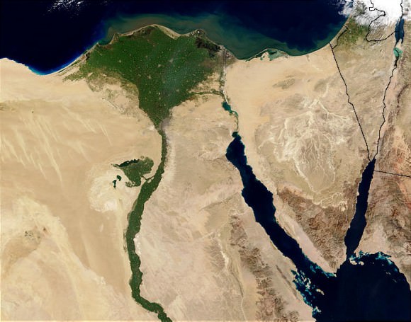
Nile Delta from space  by the MODIS sensor on the Terra satellite. Credit: Jacques Descloitres/NASA/GSFC
Nile Delta from space by the MODIS sensor on the Terra satellite.
Credit: Jacques Descloitres/NASA/GSFC

The northern section of the Nile flows entirely through the Sudanese Desert to Egypt. Historically speaking, most of the population and cities of these two countries were built along the river valley, a tradition which continues into the modern age. In addition to the capitol cities of Juba, Khartoum, and Cairo, nearly all the cultural and historical sites of Ancient Egypt are to be found along the riverbanks.

The Nile was a much longer river in ancient times. Prior to the Miocene era (ca. 23 to 5 million years ago), Lake Tangnayika drained northwards into the Albert Nile, making the Nile about 1,400 km. That portion of the river became blocked by the bulk of the formation of the Virunga Mountains through volcanic activity.

Between 8000 and 1000 B.C.E., there was also a third tributary called the Yellow Nile that connected the highlands of eastern Chad to the Nile River Valley. Its remains are known as the Wadi Howar, a riverbed that passes through the northern border of Chad and meets the Nile near the southern point of the Great Bend  – the region that lies between Khartoum and Aswan in southern Egypt where the river protrudes east and west before traveling north again.

The Nile, as it exists today, is thought to be the fifth river that has flowed from the Ethiopian Highlands. Some form of the Nile is believed to have existed for 25 million years. Satellite images have been used to confirm this, identifying dry watercourses to the west of the Nile that are believed to have been the Eonile.

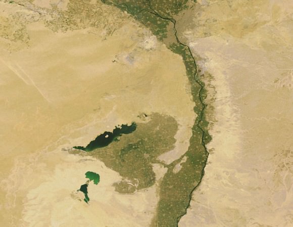
Lake Moeris and Faiyum Oasis, as seen from space, south-west of the Nile Delta and Cairo. Credit: Earth Snapshot

This “ancestral Nile” is believed to be what flowed in the region during the later Miocene, transporting sedimentary deposits to the Mediterranean Sea. During the late-Miocene Era, the Mediterranean Sea became a closed basin and evaporated to the point of being empty or nearly so. At this point, the Nile cut a new course down to a base level that was several hundred meters below sea level.

This created a very long and deep canyon which was filled with sediment, which at some point raised the riverbed sufficiently for the river to overflow westward into a depression to create Lake Moeris southwest of Cairo. A canyon, now filled by surface drift, represents an ancestral Nile called the Eonile that flowed during the Miocene.

Due to their inability to penetrate the wetlands of South Sudan, the headwaters of the Nile remained unknown to Greek and Roman explorers. Hence, it was not until 1858 when John Speke sighted Lake Victoria that the source of the Nile became known to European historians. He reached its southern shore while traveling with Richard Burton on an expedition to explore central Africa and locate the African Great Lakes.

The Temple of Luxor, Egypt, one of the most important ancient Egyptian cultural monuments, located aside the Nile. Credit: Wikipedia/Creative Commons
The Temple of Luxor, one of the most important ancient Egyptian cultural monuments, located in southern Egypt along the Nile. Credit: Wikipedia/Creative Commons

Believing he had found the source of the Nile, he named the lake after Queen Victoria, the then-monarch of the United Kingdom. Upon learning of this, Burton was outraged that Speke claimed to have found the true source of the Nile and a scientific dispute ensued.

This in turn triggered new waves of exploration that sent David Livingstone into the area. However, he failed by pushing too far to the west where he encountered the Congo River. It was not until the Welsh-American explorer Henry Morton Stanley circumvented Lake Victoria during an expedition that ran from 1874 to 1877 that Speke’s claim to have found the source of the Nile was confirmed.

The Nile became a major transportation route during the European colonial period. Many steamers used the waterway to travel through Egypt and south to the Sudan during the 19th century. With the completion of the Suez Canal and the British takeover of Egypt in the 1870s, steamer navigation of the river became a regular occurrence and continued well into the 1960s and the independence of both nations.

Today, the Nile River remains a central feature to Egypt and the Sudan. Its waters are used by all nations that it passes through for irrigation and farming, and its important to the rise and endurance of civilization in the region cannot be underestimated. In fact, the sheer longevity of Egypt’s many ruling dynasties is often attributed by historians to the periodic flows of sediment and nutrients from Lake Victoria to the delta. Thanks to these flows, it is believed, communities along the Nile River never experienced collapse and disintegration as other cultures did.

The Nile is rivaled only by Amazon, which is also the world’s widest river.

If you’d like more info on Earth, check out NASA’s Solar System Exploration Guide on Earth. And here’s a link to NASA’s Earth Observatory.

We’ve also recorded an episode of Astronomy Cast all about planet Earth. Listen here, Episode 51: Earth.

Source:
Wikipedia

NASA and NOAA Satellites Image Crippling Blizzard of 2015 Pounding New England

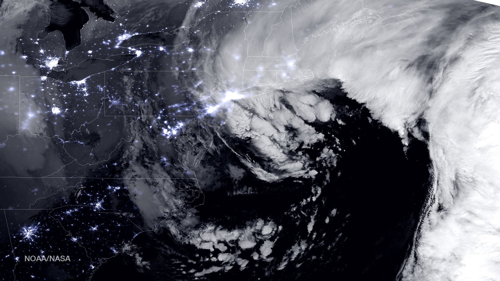
NASA-NOAA Suomi NPP satellite captures blizzard near peak intensity as it moves over New York and Boston regions at 1:45 am EST, Jan. 27, 2015. This view is a combination of the day-night band and high resolution infrared imagery from Suomi NPP showing the historic blizzard near peak intensity as it moves over the New York through Boston Metropolitan areas at 06:45Z (1:45 a.m. EST) on January 27, 2015. Credit: NOAA/NASA

NEW JERSEY – Record breaking snow from the ‘Blizzard of 2015’ hit vast regions of the US Northeast today, Jan. 27, 2015, stretching from Long Island to New England.

NASA and NOAA Earth orbiting satellites are keeping track of the storm affecting millions of residents.

This afternoon the agencies provided a new set of night-time and daytime views of the Blizzard of 2015 taken by the Suomi NPP and the GOES-East satellites.

The crippling blizzard is causing misery, extensive destruction to homes and businesses in localized areas, power outages, traffic accidents, breaks in some sea walls and deaths.

The satellite image above shows a combination of the day-night band and high resolution infrared imagery from the NASA-NOAA’s Suomi NPP satellite.

It was taken as the historic blizzard neared peak intensity as it moved over the New York area and through the Boston Metropolitan areas at 06:45Z (1:45 a.m. EST) on January 27, 2015.

The high cloud tops from the most intense parts of the storm blurred the regions normally bright nighttime lights in the satellite image.

Although the snow totals were about half the over two feet forecast for the New York Metropolitan region, many areas to the north and east were inundated with very heavy to historic snow fall totals, as bad or worse than the forecasters predicted.

Over two feet of snow fell on areas of New York’s Long Island and stretching north to vast regions of Connecticut, Massachusetts, New Hampshire and into Maine.

Near hurricane force waves are crashing into some coastal towns along the Massachusetts shoreline. Wind gusts as high as 78 mph have been recorded.

“Highest snowfall report has been Auburn, MA with 32.5 inches! Wind gust reports as high as 78 mph in Nantucket, MA,” according to a tweet this evening from the National Weather Service (NWS).

Worchester, Mass had a record breaking 31 inches of snow. And it’s still falling this evening in the 2nd largest city in New England.

A flood emergency is in effect in Marshfield, Mass., where an 80 foot section of the seawall was smashed by crashing waves and is destroying homes as shown on NBC Nightly News.

Blinding snow is raging in Portland, Maine this evening according on a live NBC News report.

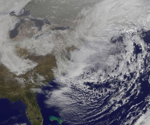
On January 27, 2015 at 17:35 UTC (12:35 p.m. EST) NOAA's Geostationary Operational Environmental or GOES- East satellite captured an image of the nor'easter over New England. Credit: NASA/NOAA GOES Project
On January 27, 2015 at 17:35 UTC (12:35 p.m. EST) NOAA’s Geostationary Operational Environmental or GOES- East satellite captured an image of the nor’easter over New England. Credit: NASA/NOAA GOES Project

“At 10 a.m. EST, the National Weather Service noted “the powerful nor’easter that brought moderate to heavy snowfall and blizzard conditions to the Northeast on Monday will continue to affect the region on Tuesday, with heavy snow and blizzard conditions expected from eastern Long Island to Maine as the system slowly moves to the northeast. Snow and strong winds will being tapering off from south to north Tuesday night into Wednesday morning,” wrote NASA’s Rob Gutro of NASA’s Goddard Space Flight Center in an update.

“Later on January 27, 2015 at 17:35 UTC (12:35 p.m. EST) NOAA’s Geostationary Operational Environmental or GOES-East satellite captured an image of the nor’easter over New England. The image was created by the NASA/NOAA GOES Project and showed the clouds associated with the nor’easter blanketing New England. An occluded front extended north and eastward out of the low pressure area’s center out into the Atlantic Ocean.”

The latest NOAA forecast as of 4 PM, Jan. 27 states:

HIGH WINDS AND HEAVY SNOW WILL BEGIN TO GRADUALLY TAPER OFF FROM SOUTH TO NORTH TONIGHT…BUT WILL LAST INTO EARLY WEDNESDAY MORNING ACROSS PORTIONS OF MAINE. HEAVY SNOWFALL WILL COMBINE WITH SUSTAINED WINDS OF 30 TO 40 MPH…AND GUSTS IN EXCESS OF 50 MPH…TO CREATE LIFE-THREATENING WHITEOUT OR BLIZZARD CONDITIONS. THESE WINDS MAY LEAD TO DOWNED TREES AND POWER LINES RESULTING IN POWER OUTAGES. TRAVEL WILL BE IMPOSSIBLE AND LIFE-THREATENING IN MANY AREAS. ALONG THE IMMEDIATE COASTLINE…WIND GUSTS TO NEAR 65 MPH WILL BE POSSIBLE. COASTAL FLOODING AND SEVERE BEACH EROSION WILL ALSO BE A POSSIBILITY…AND VULNERABLE ROADS AND STRUCTURES MAY BE FLOODED OR DAMAGED.

Stay tuned here for Ken’s continuing Earth and planetary science and human spaceflight news.

Reporting from snowy New Jersey.

Ken Kremer

Having a Rough Winter? Here it is … From Space

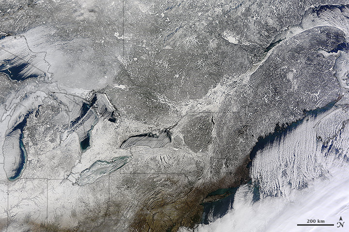
The northeastern US and southeastern Canada, as seen from space on January 13, 2015. Image is from the Moderate Resolution Imaging Spectroradiometer (MODIS) on NASA’s Terra satellite. acquired top image on January 13, 2015.

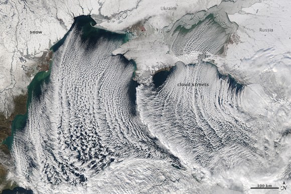
Yes, its been a snowy, icy winter in parts of the US, Canada and Europe and these satellite images look about as miserable as it’s felt for some of us. And no, those aren’t icicles hanging off the coast of Maine and Nova Scotia; those are called ‘cloud streets,’ which are long parallel bands of cumulus clouds that form when cold air blows over warmer waters (like the ocean) and a warmer air layer (temperature inversion) rests over the top of both.

But don’t let the recent cold weather and snow fool you. The Earth as a whole continues to warm, and NASA and NOAA announced today that their analysis puts 2014 as Earth’s warmest year since 1880. 2014 was the 38th straight year with above average global annual temperatures, and December 2014 was the hottest December on record. Additionally, 6 of the 12 months last year set heat records. Even though you might feel cold right now, the last time there was a monthly average global temperatures that set a record for cold was in 1916.

OK, now back to the regularly scheduled feeling sorry for ourselves for the recent cold, snowy weather… see more satellite images below.

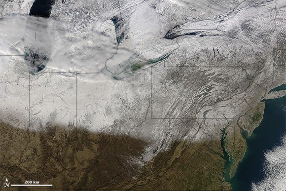
Winter storms brought snow and ice to a large portion of the U.S. Midwest and Northeast. NASA’s Aqua satellite acquired this image on January 10, 2015. Credit: NASA.
Snow and 'cloud streets' over the Black Sea on January 8, 2015. Image is from  the Moderate Resolution Imaging Spectroradiometer (MODIS) on the Aqua satellite. Credit: NASA.
Snow and ‘cloud streets’ over the Black Sea on January 8, 2015. Image is from the Moderate Resolution Imaging Spectroradiometer (MODIS) on the Aqua satellite. Credit: NASA.

Here’s a video from NASA about the latest findings on Earth’s changing climate:

Sources: NASA Earth Observatory (US/Canada images), NASA Earth Observatory (Black Sea image), NASA, NOAA Find 2014 Warmest Year in Modern Record

Spectacular Earth Timelapse Video: Christmas Gift from Alexander Gerst’s 2014 ISS Voyage

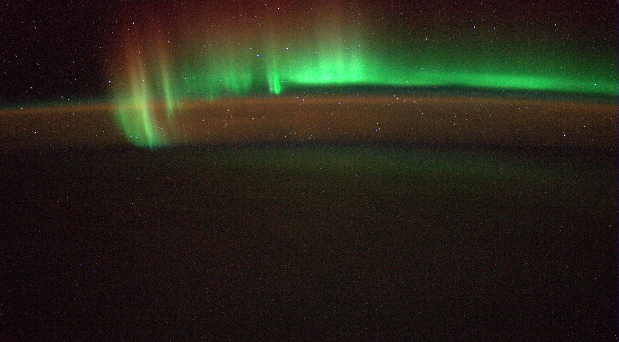
Another new snapshot of Earth’s “beautiful Southern Lights” taken from the ISS on 5 July 2014. Credit: ESA/Alexander Gerst

Video Caption: Watch the Earth roll by through the perspective of German astronaut Alexander Gerst in this 4K six-minute timelapse video of images taken from on board the International Space Station (ISS) during 2014. Credit: Alexander Gerst/ESA

ESA astronaut Alexander Gerst from Germany who recently returned from a six month voyage to the International Space Station (ISS) has a special Christmas gift for all – a stunning six-minute timelapse compilation of his favorite images of Earth taken during his “Blue Dot” mission in 2014.

“A 4K timelapse showing our planet in motion, from my favourite Earth images taken during the Blue Dot mission,” wrote Gerst in connection with his spectacular timelapse video released to coincide with Christmastime.

“I wish all of you a merry Christmas! It was a wild year for me, thanks for joining me on this fascinating journey!” said Gerst in English.

“Wünsche euch allen fröhliche Weihnachten! War ein wildes Jahr für mich, vielen Dank, dass ihr mit dabei wart!” said Gerst in German.

You can watch the Earth roll by through Gerst’s perspective in this six-minute timelapse video combining over 12,500 images taken during his six-month mission aboard the ISS that shows the best our beautiful planet has to offer.

“Marvel at the auroras, sunrises, clouds, stars, oceans, the Milky Way, the International Space Station, lightning, cities at night, spacecraft and the thin band of atmosphere that protects us from space,” according to the video’s description.

Gerst would often would set cameras to automatically take pictures at regular intervals while doing his science research or preparing for the docking of other spacecraft at the ISS in order to get the timelapse effect shown in the video.

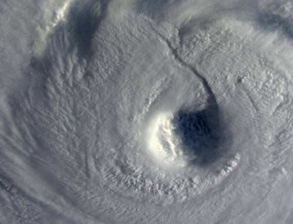
“Scary. The sunlight is far from reaching down the abyss of Neoguri's 65 km-wide eye.” Taken from the ISS on 8 July 2014. Credit: ESA/NASA/Alexander Gerst
“Scary. The sunlight is far from reaching down the abyss of Neoguri’s 65 km-wide eye.” Taken from the ISS on 8 July 2014. Credit: ESA/NASA/Alexander Gerst

The robotic arm capture and berthing of the SpaceX Dragon cargo ship and the release of the Orbital Sciences Cygnus cargo freighter are particularly magnificent in a rarely seen timelapse glimpse of visiting vehicles that are absolutely essential to keeping the station afloat, stocked, and humming with research activities.

Gerst served aboard the ISS between May and November this year as a member of the Expedition 40 and 41 crews.

Gerst launched to the ISS on his rookie space flight on May 28, 2014, aboard the Russian Soyuz TMA-13M capsule along with Russian cosmonaut Maxim Suraev and NASA astronaut Reid Wiseman.

They joined the three station flyers already aboard – cosmonauts Alexander Skvortsov & Oleg Artemyev, and astronaut Steve Swanson – to restore the station crew complement to six.

Gerst and Wiseman became well known and regarded for their prolific and expertly crafted photography skills.

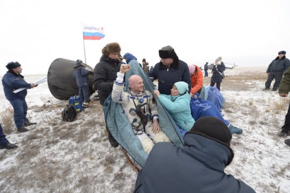
ESA astronaut Alexander Gerst, Russian commander Maxim Suraev and NASA astronaut Reid Wiseman returned to Earth on 10 November 2014, landing in the Kazakh steppe.  Credit: ESA–S. Corvaja
ESA astronaut Alexander Gerst, Russian commander Maxim Suraev, and NASA astronaut Reid Wiseman returned to Earth on 10 November 2014, landing in the Kazakh steppe. Credit: ESA–S. Corvaja

They returned to Earth safely on Nov. 10, 2014, with a soft landing on the Kazakh steppes.

Alex is Germany’s third astronaut to visit the ISS. He conducted a spacewalk with Wiseman on Oct. 7 while aboard. He is trained as a geophysicist and a volcanologist.

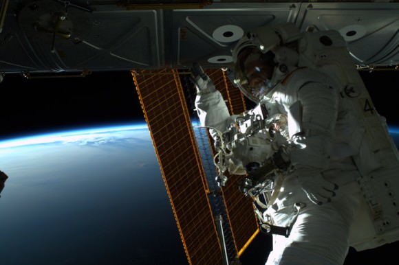
ESA astronaut Alexander Gerst spent six hours and 13 minutes outside the International Space Station with NASA astronaut Reid Wiseman on Tuesday, 7 October 2014. This was the first spacewalk for both astronauts but they performed well in the weightlessness of orbit.  Credit: NASA/ESA
ESA astronaut Alexander Gerst spent six hours and 13 minutes outside the International Space Station with NASA astronaut Reid Wiseman on Tuesday, 7 October 2014. This was the first spacewalk for both astronauts but they performed well in the weightlessness of orbit. Credit: NASA/ESA

Read my story detailing Christmas 2014 festivities with the new crews at the ISS – here.

Stay tuned here for Ken’s continuing Earth and planetary science and human spaceflight news.
Ken Kremer

NASA’s RapidScat Ocean Wind Watcher Starts Earth Science Operations at Space Station

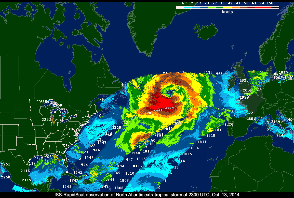
ISS-RapidScat data on a North Atlantic extratropical cyclone, as seen by the National Centers for Environmental Prediction Advanced Weather Interactive Processing System used by weather forecasters at the National Oceanic and Atmospheric Administration's Ocean Prediction Center. Image Credit: NASA/JPL-Caltech/NOAA

Barely two months after being launched to the International Space Station (ISS), NASA’s first science payload aimed at conducting Earth science from the station’s exterior has started its ocean wind monitoring operations two months ahead of schedule.

Data from the ISS Rapid Scatterometer, or ISS-RapidScat, payload is now available to the world’s weather and marine forecasting agencies following the successful completion of check out and calibration activities by the mission team.

Indeed it was already producing high quality, usable data following its power-on and activation at the station in late September and has monitored recent tropical cyclones in the Atlantic and Pacific Oceans prior to the end of the current hurricane season.

RapidScat is designed to monitor ocean winds for climate research, weather predictions, and hurricane monitoring for a minimum mission duration of two years.

“RapidScat is a short mission by NASA standards,” said RapidScat Project Scientist Ernesto Rodriguez of JPL.

“Its data will be ready to help support U.S. weather forecasting needs during the tail end of the 2014 hurricane season. The dissemination of these data to the international operational weather and marine forecasting communities ensures that RapidScat’s benefits will be felt throughout the world.”

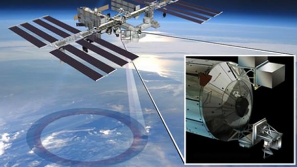
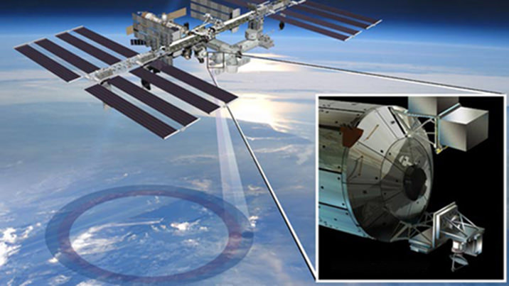
ISS-RapidScat instrument, shown in this artist's rendering, was launched to the International Space Station aboard the SpaceX CRS-4 mission on Sept. 21, 2014 and attached at ESA’s Columbus module.  It will measure ocean surface wind speed and direction and help improve weather forecasts, including hurricane monitoring. Credit: NASA/JPL-Caltech/Johnson Space Center.
ISS-RapidScat instrument, shown in this artist’s rendering, was launched to the International Space Station aboard the SpaceX CRS-4 mission on Sept. 21, 2014, and attached at ESA’s Columbus module. It will measure ocean surface wind speed and direction and help improve weather forecasts, including hurricane monitoring. Credit: NASA/JPL-Caltech/Johnson Space Center.

The 1280 pound (580kilogram) experimental instrument was developed by NASA’s Jet Propulsion Laboratory. It’s a cost-effective replacement to NASA’s former QuikScat satellite.

The $26 million remote sensing instrument uses radar pulses reflected from the ocean’s surface at different angles to calculate the speed and direction of winds over the ocean for the improvement of weather and marine forecasting and hurricane monitoring.

The RapidScat, payload was hauled up to the station as part of the science cargo launched aboard the commercial SpaceX Dragon CRS-4 cargo resupply mission that thundered to space on the company’s Falcon 9 rocket from Space Launch Complex-40 at Cape Canaveral Air Force Station in Florida on Sept. 21.

ISS-RapidScat is NASA’s first research payload aimed at conducting near global Earth science from the station’s exterior and will be augmented with others in coming years.

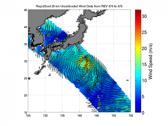
ISS-RapidScat viewed the winds within post-tropical cyclone Nuri as it moved parallel to Japan on Nov. 6, 2014 05:30 UTC. Image Credit: NASA/JPL-Caltech
ISS-RapidScat viewed the winds within post-tropical cyclone Nuri as it moved parallel to Japan on Nov. 6, 2014, 05:30 UTC. Image Credit: NASA/JPL-Caltech

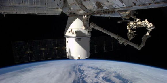
It was robotically assembled and attached to the exterior of the station’s Columbus module using the station’s robotic arm and DEXTRE manipulator over a two day period on Sept 29 and 30.

Ground controllers at Johnson Space Center intricately maneuvered DEXTRE to pluck RapidScat and its nadir adapter from the unpressurized trunk section of the Dragon cargo ship and attached it to a vacant external mounting platform on the Columbus module holding mechanical and electrical connections.

The nadir adapter orients the instrument to point its antennae at Earth.

The couch sized instrument and adapter together measure about 49 x 46 x 83 inches (124 x 117 x 211 centimeters).

“The initial quality of the RapidScat wind data and the timely availability of products so soon after launch are remarkable,” said Paul Chang, ocean vector winds science team lead at NOAA’s National Environmental Satellite, Data and Information Service (NESDIS)/Center for Satellite Applications and Research (STAR), Silver Spring, Maryland.

“NOAA is looking forward to using RapidScat data to help support marine wind and wave forecasting and warning, and to exploring the unique sampling of the ocean wind fields provided by the space station’s orbit.”

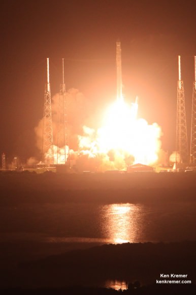
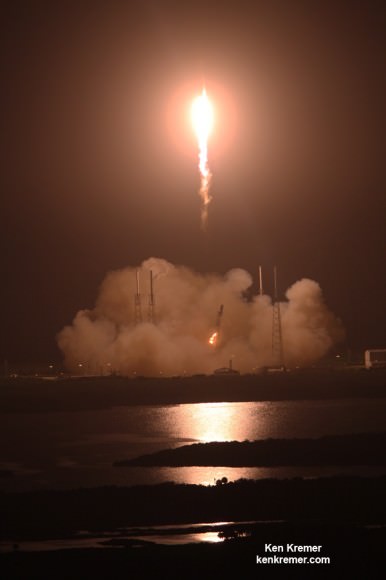
A SpaceX Falcon 9 rocket carrying a Dragon cargo capsule packed with science experiments and station supplies blasts off from Space Launch Complex 40 at Cape Canaveral Air Force Station, Florida, at 1:52 a.m. EDT on Sept. 21, 2014 bound for the ISS.  Credit: Ken Kremer/kenkremer.com
A SpaceX Falcon 9 rocket carrying a Dragon cargo capsule packed with science experiments and station supplies blasts off from Space Launch Complex 40 at Cape Canaveral Air Force Station, Florida, at 1:52 a.m. EDT on Sept. 21, 2014, bound for the ISS. Credit: Ken Kremer/kenkremer.com

This has been a banner year for NASA’s Earth science missions. At least five missions will be launched to space within a 12 month period, the most new Earth-observing mission launches in one year in more than a decade.

ISS-RapidScat is the third of five NASA Earth science missions scheduled to launch over a year.

NASA has already launched the of the Global Precipitation Measurement (GPM) Core Observatory, a joint mission with the Japan Aerospace Exploration Agency, in February and the Orbiting Carbon Observatory-2 (OCO-2) carbon observatory in July 2014.

Stay tuned here for Ken’s continuing Earth and Planetary science and human spaceflight news.
Ken Kremer

Cat 4 Hurricane Gonzalo Threatens Bermuda and Delays Antares Launch to Space Station

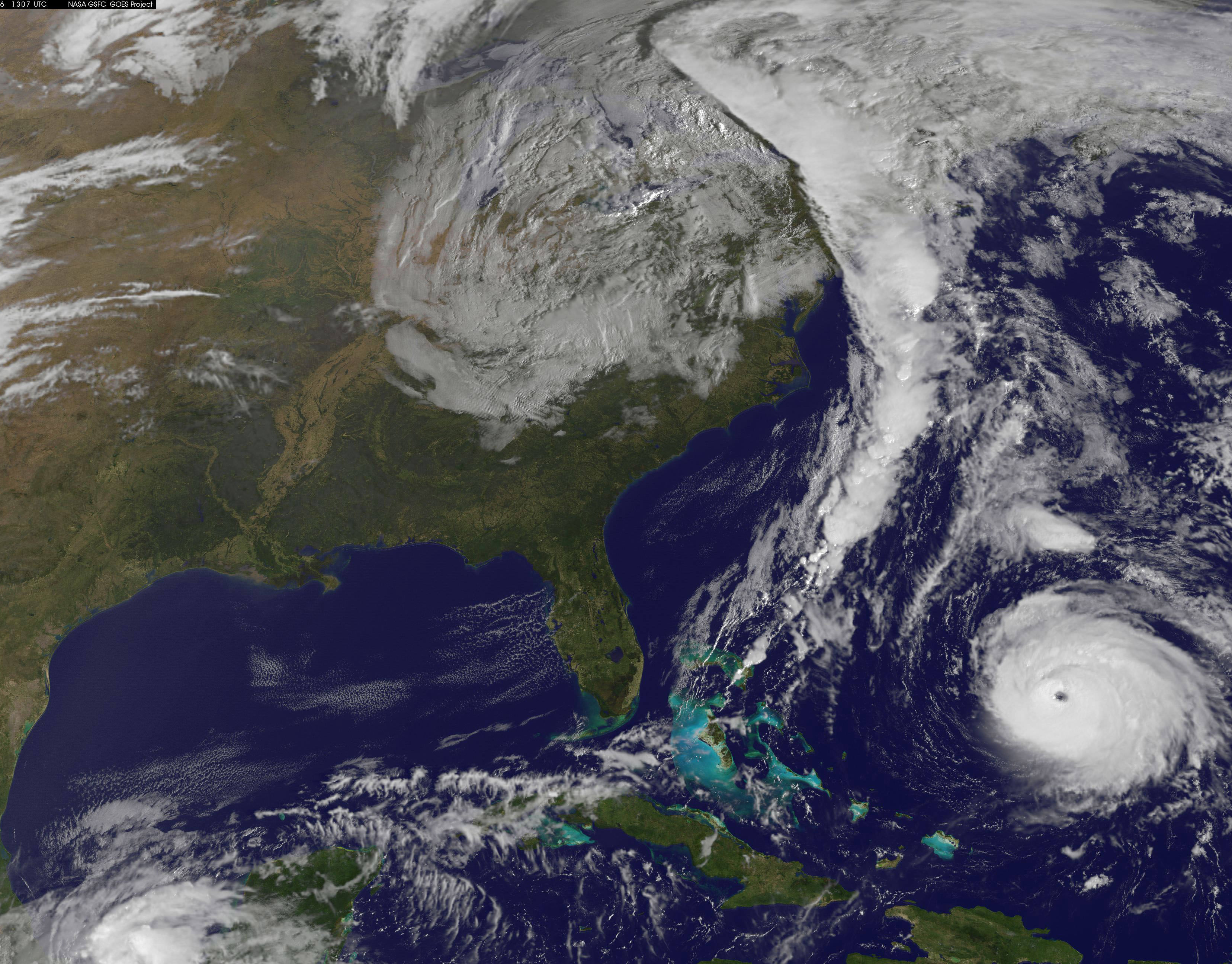
NOAA's GOES-East satellite captured this image of Hurricane Gonzalo off the U.S. East Coast on Oct. 16 at 13:07 UTC (9:07 a.m. EDT). Gonzalo is classified as Category 4 storm. Credit: NASA/NOAA GOES Project

Hurricane Gonzalo, the first major Atlantic Ocean basin hurricane in three years, has strengthened to a dangerous Category 4 storm, threatening Bermuda and forcing a postponement of the upcoming launch of the Orbital Sciences Antares rocket to the space station from the Virginia shore to no earlier than Oct. 27.

A hurricane warning is in effect for the entire island of Bermuda.

NASA and Orbital Sciences had no choice but to delay the Antares blastoff from Oct. 24 to no earlier than Oct. 27 because Bermuda is home to an “essential tracking site” that must be operational to ensure public safety in case of a launch emergency situation.

Antares had been slated for an early evening liftoff with the Cygnus cargo carrier on the Orb-3 mission to the International Space Station (ISS).

NASA and Orbital issued the following statement:

“Due to the impending arrival of Hurricane Gonzalo on the island of Bermuda, where an essential tracking site used to ensure public safety during Antares launches is located, the previously announced “no earlier than” (NET) launch date of October 24 for the Orb-3 CRS mission to the International Space Station for NASA is no longer feasible.”

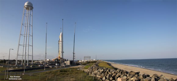
Orbital Sciences Corporation Antares rocket and Cygnus spacecraft prior to blast off on July 13  2014 from Launch Pad 0A at NASA Wallops Flight Facility , VA, on the Orb-2 mission bound for the International Space Station.  Credit: Ken Kremer - kenkremer.com
Orbital Sciences Corporation Antares rocket and Cygnus spacecraft prior to blast off on July 13 2014 from Launch Pad 0A at NASA Wallops Flight Facility , VA, on the Orb-2 mission bound for the International Space Station. Credit: Ken Kremer – kenkremer.com

The powerful Gonzalo is currently expected to make a direct hit on Bermuda on Friday afternoon, Oct. 17. It’s packing devastating maximum sustained winds exceeding 145 mph (225 kph).

NASA and NOAA satellites including the Terra, Aqua and GOES-East satellites are providing continuous coverage of Hurricane Gonzalo as it moves toward Bermuda, according to a NASA update today.

The ISS-RapidScat payload tracking ocean winds, that was just attached to the exterior of the ISS, is also designed to help with hurricane monitoring and forecasting.

Tropical storm force winds and 20 to 30 foot wave heights are expected to impact Bermuda throughout Friday and continue through Saturday and into Sunday.

“The National Hurricane Center expects hurricane-force winds, and rainfall totals of 3 to 6 inches in Bermuda. A storm surge with coastal flooding can be expected in Bermuda, with large and destructive waves along the coast. In addition, life-threatening surf and riptide conditions are likely in the Virgin Islands, Puerto Rico, Dominican Republic, Bahamas. Those dangerous conditions are expected along the U.S. East Coast and Bermuda today, Oct. 16,” according to NASA.

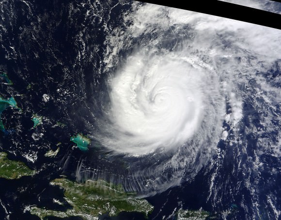
On Oct. 15 at 15:30 UTC (11:30 a.m. EDT) NASA's Terra satellite captured this image of Hurricane Gonzalo in the Atlantic Ocean. Credit: NASA Goddard MODIS Rapid Response Team
On Oct. 15 at 15:30 UTC (11:30 a.m. EDT) NASA’s Terra satellite captured this image of Hurricane Gonzalo in the Atlantic Ocean. Credit: NASA Goddard MODIS Rapid Response Team

After the hurricane passes, a team will be sent to assess the impact of the storm on Bermuda and the tracking station. Further delays are possible if Bermuda’s essential infrastructure systems are damaged, such as power, transportation and communications.

The Antares/Cygnus rocket and cargo ship launch from the Mid-Atlantic Regional Spaceport at NASA’s Wallops Flight Facility along the eastrn shore of Virginia.

Liftoff is currently target for October 27 at 6:44 p.m. (EDT). The rendezvous and berthing of Cygnus with the ISS remains on November 2, with grapple of the spacecraft by the station’s robotic arm at approximately 4:58 a.m. (EST), according to a NASA update.

Stay tuned here for Ken’s continuing Earth and Planetary science and human spaceflight news.
Ken Kremer

NASA Inaugurates New Space Station Era as Earth Science Observation Platform with RapidScat Instrument

ISS-RapidScat instrument, shown in this artist's rendering, was launched to the International Space Station aboard the SpaceX CRS-4 mission on Sept. 21, 2014 and attached at ESA’s Columbus module. It will measure ocean surface wind speed and direction and help improve weather forecasts, including hurricane monitoring. Credit: NASA/JPL-Caltech/Johnson Space Center.

NASA inaugurated a new era of research for the International Space Station (ISS) as an Earth observation platform following the successful installation and activation of the ISS-RapidScat science instrument on the outposts exterior at Europe’s Columbus module.

The ISS Rapid Scatterometer, or ISS-RapidScat, is NASA’s first research payload aimed at conducting near global Earth science from the station’s exterior and will be augmented with others in coming years.

RapidScat is designed to monitor ocean winds for climate research, weather predictions, and hurricane monitoring.

The 1280 pound (580 kilogram) experimental instrument is already collecting its first science data following its recent power-on and activation at the station.

“Its antenna began spinning and it started transmitting and receiving its first winds data on Oct.1,” according to a NASA statement.

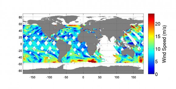
The first image from RapidScat was released by NASA on Oct. 6, shown below, and depicts preliminary measurements of global ocean near-surface wind speeds and directions.

Launched Sept. 21, 2014, to the International Space Station, NASA's newest Earth-observing mission, the International Space Station-RapidScat scatterometer to measure global ocean near-surface wind speeds and directions, has returned its first preliminary images.  Credit: NASA-JPL/Caltech
Launched Sept. 21, 2014, to the International Space Station, NASA’s newest Earth-observing mission, the International Space Station-RapidScat scatterometer to measure global ocean near-surface wind speeds and directions, has returned its first preliminary images. Credit: NASA-JPL/Caltech

The $26 million remote sensing instrument uses radar pulses to observe the speed and direction of winds over the ocean for the improvement of weather forecasting.

“Most satellite missions require weeks or even months to produce data of the quality that we seem to be getting from the first few days of RapidScat,” said RapidScat Project Scientist Ernesto Rodriguez of NASA’s Jet Propulsion Laboratory, Pasadena, California, which built and manages the mission.

“We have been very lucky that within the first days of operations we have already been able to observe a developing tropical cyclone.

“The quality of these data reflect the level of testing and preparation that the team has put in prior to launch,” Rodriguez said in a NASA statement. “It also reflects the quality of the spare QuikScat hardware from which RapidScat was partially assembled.”

RapidScat, payload was hauled up to the station as part of the science cargo launched aboard the commercial SpaceX Dragon CRS-4 cargo resupply mission that thundered to space on the company’s Falcon 9 rocket from Space Launch Complex-40 at Cape Canaveral Air Force Station in Florida on Sept. 21.

Dragon was successfully berthed at the Earth-facing port on the station’s Harmony module on Sept 23, as detailed here.

It was robotically assembled and attached to the exterior of the station’s Columbus module using the station’s robotic arm and DEXTRE manipulator over a two day period on Sept 29 and 30.

Ground controllers at Johnson Space Center intricately maneuvered DEXTRE to pluck RapidScat and its nadir adapter from the unpressurized trunk section of the Dragon cargo ship and attached it to a vacant external mounting platform on the Columbus module holding mechanical and electrical connections.

Fascinating: #Canadarm & Dextre installed the #RapidScat Experiment on Columbus! @ISS_Research @NASAJPL @csa_asc. Credit: ESA/NASA/Alexander Gerst

The nadir adapter orients the instrument to point at Earth.

The couch sized instrument and adapter together measure about 49 x 46 x 83 inches (124 x 117 x 211 centimeters).

Engineers are in the midst of a two week check out process that is proceeding normally so far. Another two weeks of calibration work will follow.

Thereafter RapidScat will begin a mission expected to last at least two years, said Steve Volz, associate director for flight programs in the Earth Science Division, NASA Headquarters, Washington, at a prelaunch media briefing at the Kennedy Space Center.

RapidScat is the forerunner of at least five more Earth science observing instruments that will be added to the station by the end of the decade, Volz explained.

The second Earth science instrument, dubbed CATS, could be added by year’s end.

The Cloud-Aerosol Transport System (CATS) is a laser instrument that will measure clouds and the location and distribution of pollution, dust, smoke, and other particulates in the atmosphere.

CATS is slated to launch on the next SpaceX resupply mission, CRS-5, currently targeted to launch from Cape Canaveral, FL, on Dec. 9.

A SpaceX Falcon 9 rocket carrying a Dragon cargo capsule packed with science experiments and station supplies blasts off from Space Launch Complex 40 at Cape Canaveral Air Force Station, Florida, at 1:52 a.m. EDT on Sept. 21, 2014 bound for the ISS.  Credit: Ken Kremer/kenkremer.com
A SpaceX Falcon 9 rocket carrying a Dragon cargo capsule packed with science experiments and station supplies blasts off from Space Launch Complex 40 at Cape Canaveral Air Force Station, Florida, at 1:52 a.m. EDT on Sept. 21, 2014, bound for the ISS. Credit: Ken Kremer/kenkremer.com

This has been a banner year for NASA’s Earth science missions. At least five missions will be launched to space within a 12 month period, the most new Earth-observing mission launches in one year in more than a decade.

ISS-RapidScat is the third of five NASA Earth science missions scheduled to launch over a year.

NASA has already launched the Global Precipitation Measurement (GPM) Core Observatory, a joint mission with the Japan Aerospace Exploration Agency in February, and the Orbiting Carbon Observatory-2 (OCO-2) carbon observatory in July 2014.

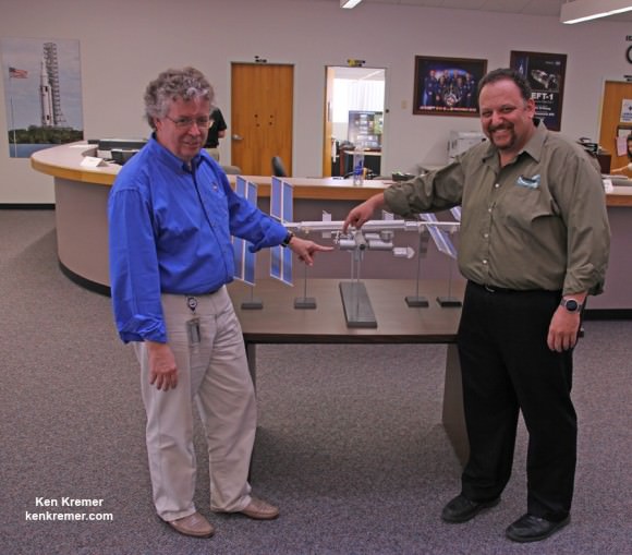
NASA managers show installed location of ISS-RapidScat instrument on the Columbus module on an ISS scale model at the Kennedy Space Center press site during launch period for the SpaceX CRS-4 Dragon cargo mission.  Posing are Steve Volz, associate director for flight programs in the Earth Science Division, NASA Headquarters, Washington and Howard Eisen, RapidScat Project Manager.  Credit: Ken Kremer - kenkremer.com
NASA managers show installed location of ISS-RapidScat instrument on the ESA Columbus module on an ISS scale model at the Kennedy Space Center press site during launch period for the SpaceX CRS-4 Dragon cargo mission. Posing are Steve Volz, associate director for flight programs in the Earth Science Division, NASA Headquarters, Washington, and Howard Eisen, RapidScat Project Manager. Credit: Ken Kremer – kenkremer.com

Stay tuned here for Ken’s continuing Earth and Planetary science and human spaceflight news.
Ken Kremer

…………….

Learn more about Commercial Space Taxis, Orion and NASA Human and Robotic Spaceflight at Ken’s upcoming presentations:

Oct 14: “What’s the Future of America’s Human Spaceflight Program with Orion and Commercial Astronaut Taxis” & “Antares/Cygnus ISS Rocket Launches from Virginia”; Princeton University, Amateur Astronomers Assoc of Princeton (AAAP), Princeton, NJ, 7:30 PM

Oct 23/24: “Antares/Cygnus ISS Rocket Launch from Virginia”; Rodeway Inn, Chincoteague, VA

One More Absolutely Amazing Timelapse from the International Space Station

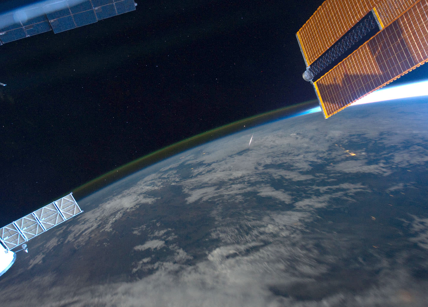
Perseid meteor as seen from the ISS by astronaut Ron Garan on August 13, 2011. Credit: NASA/Ron Garan.

We’ve featured several timelapse compilations of footage and imagery taken from the International Space Station (like here, here and here) but this one put together by Phil Selmes is great in that it also includes footage *of* the ISS, as shot by the astronauts on the space shuttle as well as actual space to ground audio communications. Phil said he included the audio clips “to remind the audience of the humanity that inhabits the space station.”

There is just something about these videos from the ISS that speaks to your soul. Phil told Universe Today that while putting this together, he saw “how different our world looks just 370kms above our heads. I didn’t see politics, races, borders, countries, religions or differences,” he said via email. “I saw one planet, one world, one incredibly beautiful miracle in the absolute vastness of the universe. It gave me some perspective, ironically it brought me ‘back to earth.’”

The video and imagery is from the Johnson Space Center’s Gateway to Astronaut Photography of the Earth.

Look for more #TimelapseThursday videos in the weeks to come.

Spectacular Ultra-High Definition Timelapse from the Space Station

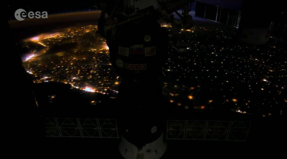
Imagery from the new ESA timelapse in 4K from the International Space Station.

Holy moly! Take a look at this new 4K timelapse video from ESA created from imagery taken by astronaut Alexander Gerst. Before you watch, however, you might want to change your video viewing setting to as high as they can go.

The imagery was taken at a resolution of 4256 x 2832 pixels at a rate of one every second. ESA said the high resolution allowed their production team to create a 3840 x 2160 pixel movie, also known as Ultra HD or 4K.

Playing these sequences at 25 frames per second, the film runs 25 times faster than it looks for the astronauts in space. They also did some nice effects creating trails from from stars and lights from cities on Earth for that “hyper-space” look. There’s a great sequence starting at about :55 of the Orbital Cygnus capsule being unberthed from the ISS and then it zooms away from the station.