And the Coldest Place on Earth Is …

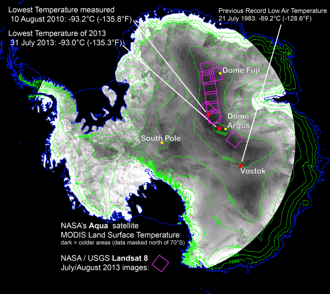
With remote-sensing satellites, scientists have found the coldest places on Earth, just off a ridge in the East Antarctic Plateau. The coldest of the cold temperatures dropped to minus 135.8 F (minus 93.2 C) -- several degrees colder than the previous record. Image Credit: Ted Scambos, National Snow and Ice Data Center.

What is the coldest place on Earth? Scientists say it’s a place so cold that ordinary mercury or alcohol thermometers won’t work there. If you were there, every breath would be painful, your clothing would crackle every time you moved, and if you threw hot water into the air, it would fall to the ground as tiny shards of ice. At this place, the new record of minus 136 F (minus 93.2 C) was set on Aug. 10, 2010. Researchers analyzed data from several satellite instruments and found the coldest place on Earth in the past 32 years is … a high ridge in Antarctica between Dome Argus and Dome Fuji, two summits on the ice sheet known as the East Antarctic Plateau. Temperatures in several hollows were found to dip to the new record.

“We had a suspicion this Antarctic ridge was likely to be extremely cold,” said Ted Scambos, from the National Snow and Ice Data Center in Boulder, Colorado. “With the launch of Landsat 8, we finally had a sensor capable of really investigating this area in more detail.”

This beats out the previous low of minus 128.6 F (minus 89.2 C), set in 1983 at the Russian Vostok Research Station in East Antarctica. The coldest permanently inhabited place on Earth is northeastern Siberia, where temperatures in the towns of Verkhoyansk and Oimekon dropped to a bone-chilling 90 degrees below zero Fahrenheit (minus 67.8 C) in 1892 and 1933, respectively.

Scambos and his team made the discovery while analyzing the most detailed global surface temperature maps to date, developed with data from remote sensing satellites. The new findings were reported at the American Geophysical Union meeting in San Francisco.

The pursuit to find the coldest place on Earth started when the researchers were studying large snow dunes, sculpted and polished by the wind, on the East Antarctic Plateau. When the scientists looked closer, they noticed cracks in the snow surface between the dunes, possibly created when wintertime temperatures got so low the top snow layer shrunk. This led scientists to wonder what the temperature range was, and prompted them to hunt for the coldest places using data from two types of satellite sensors.

They used data from the Moderate Resolution Imaging Spectroradiometer (MODIS) instruments on NASA’s Terra and Aqua satellites and the Advanced Very High Resolution Radiometer (AVHRR) on several National Oceanic and Atmospheric Administration satellites. These sensitive instruments can pick up thermal radiation emitted from Earth’s surface, even in areas lacking much heat.

Using these sensors to scan the East Antarctic Plateau, Scambos detected extremely cold temperatures on a 620-mile stretch of the ridge at high elevations between Argus and Fuji, and even colder temperatures lower elevations in pockets off the ridge. Then, with the higher resolution of the Thermal Infrared Sensor (TIRS) aboard Landsat 8, the research team pinpointed the record-setting pockets.

The team compared the sites to topographic maps to explore how it gets so cold. Already cold temperatures fall rapidly when the sky clears. If clear skies persist for a few days, the ground chills as it radiates its remaining heat into space. This creates a layer of super-chilled air above the surface of the snow and ice. This layer of air is denser than the relatively warmer air above it, which causes it to slide down the shallow slope of domes on the Antarctic plateau. As it flows into the pockets, it can be trapped, and the cooling continues.

“By causing the air to be stationary for extended periods, while continuing to radiate more heat away into space, you get the absolute lowest temperatures we’re able to find,” Scambos said. “We suspected that we would be looking for one magical site that got extremely cold, but what we found was a large strip of Antarctica at high altitude that regularly reached these record low temperatures.”

Source: NASA

Awesome ‘Sideways’ View from Space of the Erupting Kliuchevskoi Volcano

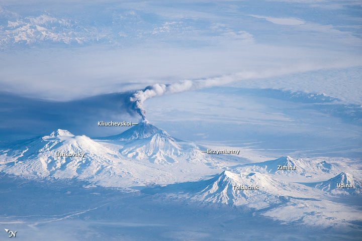
Image taken by astronauts on the International Space Station showing an oblique view of an eruption plume emanating from the Kliuchevskoi volcano on Russia’s Kamchatka Peninsula. Credit: NASA.

We’ve seen some great views from space of erupting volcanoes, like Pavlov, Shiveluch, and Nabro. While most of the views from space look straight down in a in a nadir view, this photo was taken from the International Space Station with an oblique or sideways viewing angle. This provides a three-dimensional-type view, similar to what might be seen from an airplane instead of a flattened view that looks straight down. This image was taken by an astronaut when the ISS was located over a ground position more than 1,500 kilometers (900 miles) to the southwest of the Kamchatka Peninsula in the far eastern part of Russia. The Kliuchevskoi volcano is just one of 160 volcanoes in this region, with 29 of the 160 being active.

NASA says the plume—likely a combination of steam, volcanic gases, and ash—stretched to the east-southeast due to prevailing winds. The dark region to the north-northwest is likely a product of shadows and of ash settling out. Several other volcanoes are visible in the image, including Ushkovsky, Tolbachik, Zimina, and Udina. To the south-southwest of Kliuchevskoi lies Bezymianny Volcano, which appears to be emitting a small steam plume (at image center).

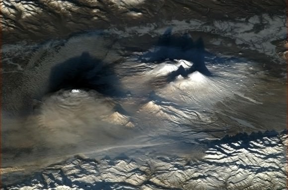
These volcanic peaks are an eye-catching landmark from orbit. Here’s an image of the same region taken by astronaut Chris Hadfield earlier this year:

Volcanoes of Kamchatka, Russia at dawn, as seen from the International Space Station. Credit: NASA/CSA/Chris  Hadfield
Volcanoes of Kamchatka, Russia at dawn, as seen from the International Space Station. Credit: NASA/CSA/Chris Hadfield

Source: NASA Earth Observatory

UrtheCast: Cameras for Live Video Views of Planet Earth To Launch Nov. 25

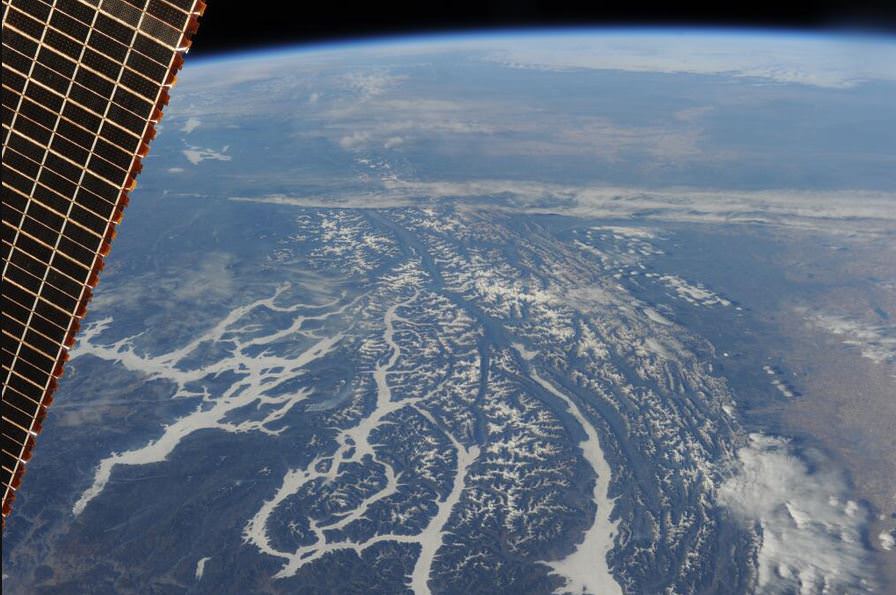
A view of rivers in Montana, USA, from the ISS. Credit: ESA/Luca Parmitano.

A Canadian camera system aiming to provide near-realtime video views of Earth is readying for a launch from Kazakhstan.

If all goes well, the UrtheCast dual camera system will blast off in a Progress supply ship on Nov. 25, 2013.

This will be the world’s first ever high definition, live-streaming video platform of planet Earth from the International Space Station.

“Imagine you have a nearly live Google Earth, but it isn’t four year old data – you have data that is being refreshed all the time, with videos coming down over interesting areas where interesting events are going on, showing you what is changing, what is going on,” said George Tyc, the Chief Technology Officer at UrtheCast, in an interview with Universe Today earlier this year. “What we really hope to pull off is to change the paradigm, get the everyday person interacting and seeing the data coming down from space to see the Earth and how it is evolving over time in a way that isn’t available right now.”

Last week at the Canadian Space Society Summit, UrtheCast co-founder Wade Larson explained the camera setup will take place in phases, with Phase 1 of the project having two cameras facing the ground, with one having a fixed gaze and the other one featuring maneuverability to points of interest. These should be installed on the station sometime in December 2013, Larson said, with data coming in the first quarter of 2014.

The company’s aim is to make Earth video data more accessible to individuals and schoolchildren, who would log in on UrtheCast’s website, as well as the traditional customers of government and private companies. Additionally, a recent partnership agreement with the UN will see them offer real-time information on dynamic situations such as floods and mass movements of people during humanitarian disasters. They will also be integrating the data with live social media feeds as well as opening up their API for app developers.

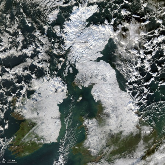
The UK covered in snow, as seen on Dec. 8, 2010. Credit: NASA's Aqua satellite.
The UK covered in snow, as seen on Dec. 8, 2010. Credit: NASA’s Aqua satellite.

Current sponsors on the project from UrtheCast (pronunced “Earthcast”) include Roscosmos, MacDonald, Dettwiler and Associates, the Discovery Channel, Energia, Unosat and RAL Space, Larson added.

The UrtheCast team is working in an exclusive relationship with the Russian Aerospace giant RSC Energia (NASA is not involved at all), and cosmonauts on board the ISS will install the cameras. The video data of the Earth will be down-linked to ground stations around the planet and then displayed in near real time on the UrtheCast web platform.

“We had to meet quite a strict set of requirements that the cameras are safe for cosmonauts and astronauts,” Tyc said, “as there can’t be any toxic substances because they will be inside the ISS before they are installed.”

Tyc added that it will take two spacewalks to do the full installation. The cameras are expected to last at least five years, and Tyc expects them to be up there even longer. “We’re looking at putting additional cameras up there for a second generation, and we expect to be up there for the life of the station, really,” he said.

Tyc said he thinks the social media aspect of UrtheCast will be a big part of the entire experience.

“For example, in a natural disaster or big event we’ll also incorporate videos from the ground of things going on, to experience an event in a far different way than you can now,” he said. “And it’s not being filtered through a media agency — it is what it is – and people can draw their own conclusions and add their own voice.”

Tyc said that if the concept takes off, they think this will be a shift in how people can interact with others around the world. “It could be a feeling of the Overview effect – people who go to space are have a completely changed perspective – we’re trying to bring a little bit of that to the ground,” he said.

The team said the name UrtheCast is a bit of a double entendre, as it is pronounced like “EarthCast” but also looks like “You Are the Cast” since it will be live views of planet Earth.

Find out more at the UrtheCast website.


Nancy Atkinson also contributed to this report.

‘Force Field’ Could Protect New Weather Satellite, Future Human Missions

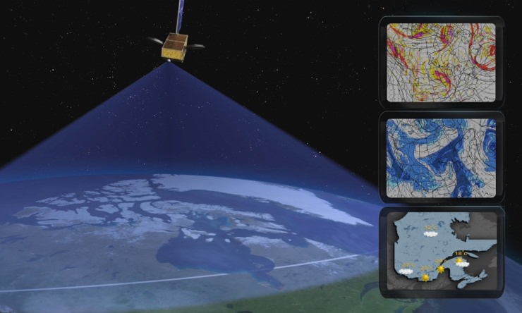
Typical meteorological applications for the Polar Communications and Weather (PCW) mission. Credit: CSA.

OTTAWA, CANADA — A new Canadian satellite — should it launch — might carry a sort of magnetized force field on board to keep charged particles away from vital electronics.

The Polar Communications and Weather Satellite (PCW), depending on its orbit, could skim through the radiation-filled Van Allen belts on its mission to deliver reliable weather reports and communications to northern communities.

Its polar orbit will likely take it through clouds of charged particles high above Earth. If the particles hit crucial components on the spacecraft, it can short out electronics and cause brownouts or complete failure. This has happened several times before, such as to the Japanese ADEOS-II satellite after a large solar storm in 2003.

A concept being explored by Winnipeg’s Magellan Aerospace, one of the companies working on the early phase studies, would make a plasma field around PCW, a sort of “mini magnetosphere” that would use large dipole magnets to deflect charged particles.

It may also be useful for human missions in the future, said Paul Harrison, a satellite control systems engineer at Magellan Aerospace, although he acknowledged the technology is still in an early stage and that they would like a demonstrator mission to fly first.

“It’s still very much in the development phase. We want to develop for satellites before we start sticking people in them,” Harrison said in a presentation at the Canadian Space Society annual summit in Ottawa, Canada, today (Nov. 14.)

He also said it is not clear if the technology would be useful for cosmic rays that originate from outside the solar system, as well as charged particles that flow from the sun and are present near the Earth.

pcw_banner_e

PCW has not been assigned a launch date yet and is still in the early stages of development. Other issues being explored include how to keep track of it without constant access to near-equator-orbiting GPS satellites, and how to maintain temperature control as it plunges from day to night to day again during its journey.

Its orbit could be a 12-hour Molniya orbit or perhaps a 16-hour or 24-hour highly eccentric orbit, depending on what designers feel is best.

CORRECTION: This article has been changed to say “near-equator-orbiting” GPS satellites.

10-Year-Old Boy Discovers a 600 Million Year-Old Supernova

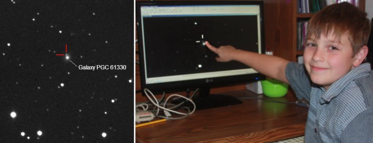
Canadian Nathan Gray (right) is likely the youngest person to discover a supernova. The supernova candidate (left) is probably located some 600 million light-years away (image from the ARO--Dave Lane). Follow-up observations will soon be acquired to confirm the supernova's class and nature.

Young Canadian Nathan Gray, age 10, has discovered a supernova candidate in the field of the galaxy designated PGC 61330, which lies in the constellation of Draco (the dragon).

Nathan made the discovery while scanning astronomical images taken by Dave Lane, who runs the Abbey Ridge Observatory (ARO) which is stationed in Nova Scotia.  Incidentally, Nathan may unseat his older sister, Kathryn Aurora Gray, as the youngest supernova discoverer by a mere 33 days.

Nothing is visible at the location of the supernova candidate in prior images of the field taken over the past two years, or Digitized Palomar Sky Survey images.

Kathryn Aurora Gray garnered worldwide fame when she discovered a supernova in the galaxy designated UGC 3378 (see the Universe Today article by Nancy Atkinson). The discovery eventually earned her an audience with astronauts such as Neil Armstrong (shown below).

Kathryn Aurora Gray discovery of a supernova earned her the chance to meet Neil Armstrong, Bill Anders (Apollo 8), Victor Gorbakto, and Jim Lovell (Apollo 8 & 13).
Kathryn Aurora Gray’s discovery of a supernova earned her the chance to meet Neil Armstrong, Bill Anders (Apollo 8), Victor Gorbakto, and Jim Lovell (Apollo 8 & 13) (image credit: P. Gray/RASC).

Caroline Moore held the record prior to Kathryn as the youngest person to discover a supernova (Caroline was 14 at the time). Caroline subsequently had the honor of meeting President Obama at the White House (see the video below).

Supernova are immense explosions linked to the evolutionary end-state of certain stars. The explosions are so energetic that they can be observed in distant galaxies. Indeed, Nathan’s supernova could be some 600 million light years distant.  Gazing into space affords humanity the opportunity to peer back in time. Despite the (finite) speed of light being a remarkable 300000 km/s, the light-rays must travel over “astronomical” distances.

There are several different classes of supernovae. For example, Type II supernovae are associated with larger mass stars. The Sun will not terminate as a supernova, but may potentially evolve into a standard (or not) planetary nebula (see the Universe Today post “Astronomers Hint that our Sun won’t Terminate as the Typical Planetary Nebula”).

Nathan’s discovery has been posted on the International Astronomical Union’s site, and its presence confirmed by US and Italian-based observers. Its provisional name is: PSN J18032459+7013306, and to get an official supernova designation a large telescope needs to confirm the unique supernova light signature (via a spectrum).  Is the target a bona fide supernova?

“Given no motion, large distance from the galactic plane (ie. not likely a nova), and several optical confirmations, as well as its very close angular proximity to a faint galaxy, it is a supernova at any reasonable certainty,” said Lane, an astronomer in the Dept. of Astronomy & Physics at Saint Mary’s University, as well as the director of the Burke-Gaffney and Abbey Ridge astronomical observatories. “A significant fraction of
the supernova discoveries these days are not observed spectrographically due to the sheer number of them vs. telescope time.”

Nathan Gray is the son of Paul and Susan Gray.

*2013 10 31.9053 – update from the IAU: SN to be confirmed in PGC 61330 detected with 3 x 3 min images (exp 9 min). Astrometry: RA 18 03 24.12 Dec +70 13 26.4 (ref stars UCAC2) Photometry: 17.00CR +/-0.02 (USNO A2R Ref stars 163R, 170R, 172R, 173R). Measure on unfiltered image. Observer and measurer: Xavier Bros, ANYSLLUM OBSERVATORY, Ager, Spain. T-350mm f4.6. Link to image and further information: http://www.anysllum.com/PSN_PGC61330.jpg

Astronomy Cast 319: The Zodiac

Although the Zodiac is best known for astrology nonsense, it has a purpose in astronomy too. The constellations of the Zodiac define the plane of the ecliptic: the region where the Sun, Moon and planets appear to travel through the sky. What are the constellations of the Zodiac, and how do astronomers use them as way points?

We record Astronomy Cast as a live Google+ Hangout on Air every Monday at 12:00 pm Pacific / 3:00 pm Eastern. You can watch here on Universe Today or from the Astronomy Cast Google+ page.

Virtual Star Party – October 20, 2013: In Space, Nobody can Hear You Waka-Waka-Waka-Waka!

Sunday’s Virtual Star Party felt like a reunion, with Mike Phillips, Gary Gonella, and Roy Salisbury supplying images and Scott Lewis co-hosting. We were joined by newcomer James McGee streaming a beautiful view of the Moon – when it wasn’t blocked by his apartment tower.

The Moon was just past full, so it commanded attention, but we still got a beautiful view of some fainter nebulae, galaxies and star clusters.

Astronomers: Mike Phillips, Gary Gonella, Roy Salisbury, James McGee

Hosts: Fraser Cain, Scott Lewis

Objects: The Moon, Pac Man Nebula, Eagle Nebula, Swan Nebula, Lagoon Nebula, Andromeda Galaxy, M15 globular cluster, Dumbbell Nebula, Veil Nebula and more.

We hold the Virtual Star Party every Sunday night when it gets dark on the West Coast of North America. You can watch it live on Universe Today, on Google+, or from the Universe Today YouTube Channel.

Virtual Star Party – October 13, 2013

We’ve got a pretty bright Moon, but that just means we’ve got another target for the Virtual Star Party.

Tonight we had beautiful views of the Moon from David Dickinson and Cory Schmitz, and then some deep sky objects from Gary Gonella and Cory. We saw Andromeda Galaxy, Bubble Nebula, Swan Nebula, Lagoon Nebula, Dumbbell Nebula. And some viewers shared their photographs, including some amazing images of the International Space Station.

Host: Fraser Cain

Astronomers: Cory Schmitz, Gary Gonella, David Dickinson

We hold the Virtual Star Party every Sunday night as a live Google+ Hangout on Air. We begin the show when it gets dark on the West Coast. If you want to get a notification, make sure you circle the Virtual Star Party on Google+. You can watch on our YouTube channel or here on Universe Today.

Jupiter-bound Juno Probe Back in Full Operation After Earth Flyby Glitch

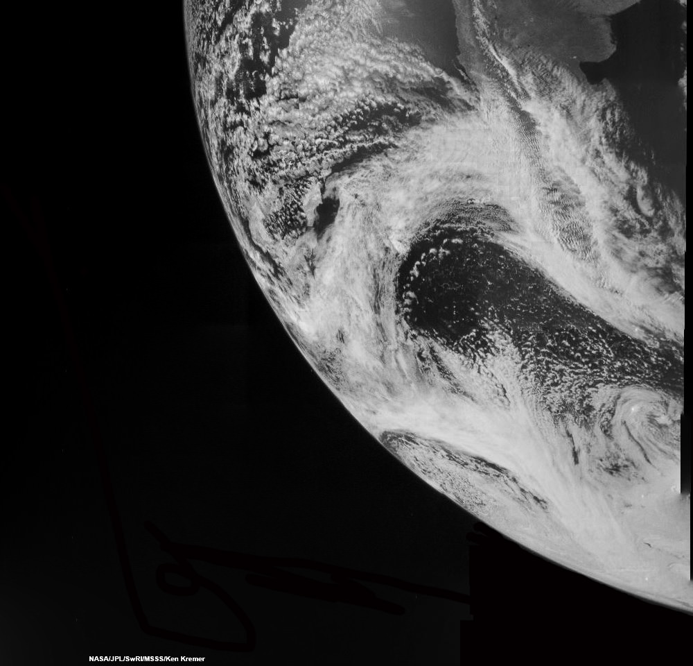
Juno swoops over Argentina This reconstructed day side image of Earth is one of the 1st snapshots transmitted back home by NASA’s Jupiter-bound Juno spacecraft during its speed boosting flyby on Oct. 9, 2013. It was taken by the probes Junocam imager and methane filter at 12:06:30 PDT and an exposure time of 3.2 milliseconds. Juno was flying over South America and the southern Atlantic Ocean. The coastline of Argentina is visible at top right. Credit: NASA/JPL/SwRI/MSSS/Ken Kremer

Juno swoops over Argentina
This reconstructed day side image of Earth is one of the 1st snapshots transmitted back home by NASA’s Jupiter-bound Juno spacecraft during its speed boosting flyby on Oct. 9, 2013. It was taken by the probes Junocam imager and methane filter at 12:06:30 PDT and an exposure time of 3.2 milliseconds. Juno was flying over South America and the southern Atlantic Ocean. The coastline of Argentina is visible at top right. Credit: NASA/JPL/SwRI/MSSS/Ken Kremer
See another cool Junocam image below[/caption]

Engineers have deftly managed to successfully restore NASA’s Jupiter-bound Juno probe back to full operation following an unexpected glitch that placed the ship into ‘safe mode’ during the speed boosting swing-by of Earth on Wednesday, Oct. 9 – the mission’s top scientist told Universe Today late Friday.

Juno came out of safe mode today!” Juno principal investigator Scott Bolton happily told me Friday evening. Bolton is from the Southwest Research Institute (SwRI), San Antonio, Texas.

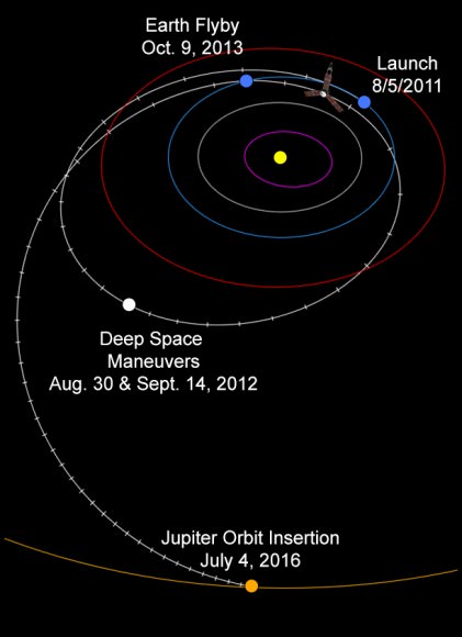
The solar powered Juno spacecraft conducted a crucial slingshot maneuver by Earth on Wednesday that accelerated its velocity by 16,330 mph (26,280 km/h) thereby enabling it to be captured into polar orbit about Jupiter on July 4, 2016.

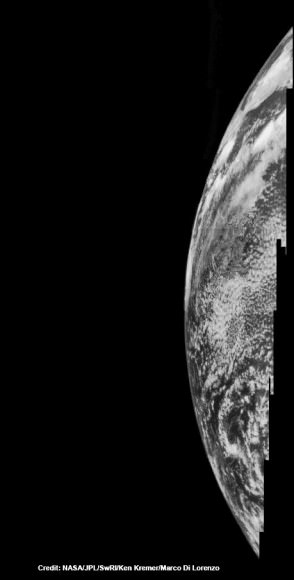
Dayside view of a sliver of Earth snapped by Juno during flyby on Oct. 9, 2013.  This mosaic has been reconstructed from raw image data captured by methane infrared filter on Junocam imager at 11:57:30 PDT.  Credit: NASA/JPL/SwRI/MSSS/Ken Kremer/Marco Di Lorenzo
Dayside view of a sliver of Earth snapped by Juno during flyby on Oct. 9, 2013. This mosaic has been reconstructed from raw image data captured by methane infrared filter on Junocam imager at 11:57:30 PDT. Credit: NASA/JPL/SwRI/MSSS/Ken Kremer/Marco Di Lorenzo

“The safe mode did not impact the spacecraft’s trajectory one smidgeon!”

Juno exited safe mode at 5:12 p.m. ET Friday, according to a statement from the Southwest Research Institute. Safe mode is a designated fault protective state that is preprogrammed into spacecraft software in case something goes amiss.

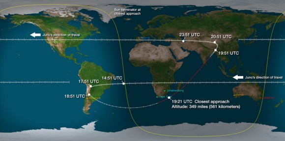
Juno’s flight track above Earth during Oct. 9, 2013 flyby. Credit: NASA/JPL

“The spacecraft is currently operating nominally and all systems are fully functional,” said the SwRI statement.

Although the Earth flyby did accomplish its primary goal of precisely targeting Juno towards Jupiter – within 2 kilometers of the aim point ! – the ship also suffered an unexplained anomaly that placed Juno into ‘safe mode’ at some point during the swoop past Earth.

“After Juno passed the period of Earth flyby closest approach at 12:21 PM PST [3:21 PM EDT] and we established communications 25 minutes later, we were in safe mode,” Juno Project manager Rick Nybakken, told me in a phone interview soon after Wednesday’s flyby of Earth. Nybakken is from NASA’s Jet Propulsion Lab in Pasadena, CA.

Credit: NASA/JPL
Credit: NASA/JPL

Nybakken also said that the probe was “power positive and we have full command ability.”

So the mission operations teams at JPL and prime contractor Lockheed Martin were optimistic about resolving the safe mode issue right from the outset.

“The spacecraft acted as expected during the transition into and while in safe mode,” acording to SwRI.

During the flyby, the science team also planned to observe Earth using most of Juno’s nine science instruments since the slingshot also serves as an important dress rehearsal and key test of the spacecraft’s instruments, systems and flight operations teams.

“The Juno science team is continuing to analyze data acquired by the spacecraft’s science instruments during the flyby. Most data and images were downlinked prior to the safe mode event.”

Juno’s closest approach took place over the ocean just off the tip of South Africa at about 561 kilometers (349 miles).

Juno launched atop an Atlas V rocket two years ago from Cape Canaveral Air Force Station, FL, on Aug. 5, 2011 on a journey to discover the genesis of Jupiter hidden deep inside the planet’s interior.

The $1.1 Billion Juno probe is continuing on its 2.8 Billion kilometer (1.7 Billion mile) outbound trek to the Jovian system.

During a one year long science mission – entailing 33 orbits lasting 11 days each – the probe will plunge to within about 3000 miles of the turbulent cloud tops and collect unprecedented new data that will unveil the hidden inner secrets of Jupiter’s origin and evolution.

“Jupiter is the Rosetta Stone of our solar system,” says Bolton. “It is by far the oldest planet, contains more material than all the other planets, asteroids and comets combined and carries deep inside it the story of not only the solar system but of us. Juno is going there as our emissary — to interpret what Jupiter has to say.”

Read more about Juno’s flyby in my articles – at NBC News; here, and Universe Today; here, here and here

Ken Kremer

NASA’s Juno Spacecraft Returns 1st Flyby images of Earth while Sailing On to Jupiter

Juno swoops over Argentina This reconstructed day side image of Earth is one of the 1st snapshots transmitted back home by NASA’s Jupiter-bound Juno spacecraft during its speed boosting flyby on Oct. 9, 2013. It was taken by the probes Junocam imager and methane filter at 12:06:30 PDT and an exposure time of 3.2 milliseconds. Juno was flying over South America and the southern Atlantic Ocean. The coastline of Argentina is visible at top right. Credit: NASA/JPL/SwRI/MSSS/Ken Kremer

Following the speed boosting slingshot of Earth on Wednesday, Oct. 9, that sent NASA’s Juno orbiter hurtling towards Jupiter, the probe has successfully transmitted back data and the very first flyby images despite unexpectedly going into ‘safe mode’ during the critical maneuver.

Juno is transmitting telemetry today,” spokesman Guy Webster, of NASA’s Jet Propulsion Lab (JPL), told me in a phone interview late today (Oct. 10), as Juno continues sailing on its 2.8 Billion kilometer (1.7 Billion mile) outbound trek to the Jovian system.

The new images of Earth captured by the Junocam imager serves as tangible proof that Juno is communicating.

“Juno is still in safe mode today (Oct. 10),” Webster told Universe Today.

“Teams at mission control at JPL and Lockheed Martin are actively working to bring Juno out of safe mode. And that could still require a few days,” Webster explained.

Lockheed Martin is the prime contractor for Juno.

The initial raw images of Earth snapped by the craft’s Junocam imager were received by ground stations late today.

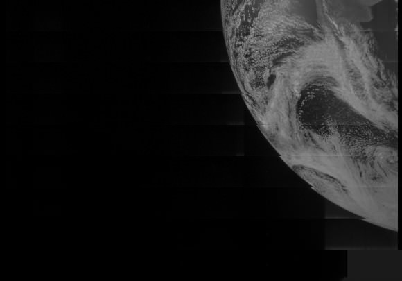
See above a day light image mosaic which I reconstructed and realigned based on the original raw image (see below) taken with the camera’s methane filter on Oct. 9 at 12:06:30 PDT (3:06:30 PM EST). Juno was to be flying over South America and the southern Atlantic Ocean.

This day side raw image of Earth is one of the 1st snapshots transmitted back home today by NASA’s Juno spacecraft during its speed boosting flyby on Oct. 9, 2013. It was taken by the probes Junocam imager and methane filter at 12:06:30 PDT and an exposure time of 3.2 ms. Credit: NASA/JPL/SwRI/MSSS
This day side raw image of Earth is one of the 1st snapshots transmitted back home today by NASA’s Juno spacecraft during its speed boosting flyby on Oct. 9, 2013. It was taken by the probes Junocam imager and methane filter at 12:06:30 PDT and an exposure time of 3.2 milliseconds. Juno was due to be flying over South America and the southern Atlantic Ocean. Credit: NASA/JPL/SwRI/MSSS

Juno performed a crucial swingby of Earth on Wednesday that accelerated the probe by 16330 MPH to enable it to arrive in orbit around Jupiter on July 4, 2016.

However the gravity assist maneuver did not go entirely as planned.

Shortly after Wednesday’s flyby, Juno Project manager Rick Nybakken, of JPL, told me in a phone interview that Juno had entered safe mode but that the probe was “power positive and we have full command ability.”

“After Juno passed the period of Earth flyby closest approach at 12:21 PM PST [3:21 PM EDT] and we established communications 25 minutes later, we were in safe mode,” Nybakken explained.

The safe mode was triggered while Juno was in an eclipse mode, the only eclipse it will experience during its entire mission.

The Earth flyby did accomplish its objective by placing the $1.1 Billion Juno spacecraft exactly on course for Jupiter as intended.

“We are on our way to Jupiter as planned!”

“None of this affected our trajectory or the gravity assist maneuver – which is what the Earth flyby is,” Nybakken stated.

Juno’s closest approach was over South Africa at about 561 kilometers (349 miles).

Juno’s flight track above Earth during Oct. 9, 2013 flyby. Credit: NASA/JPL

During the flyby, the science team also planned to observe Earth using most of Juno’s nine science instruments since the slingshot also serves as a key test of the spacecraft systems and the flight operations teams.

Juno also was to capture an unprecedented new movie of the Earth/Moon system.

Many more images were snapped and should be transmitted in coming days that eventually will show a beautiful view of the Earth and Moon from space.

“During the earth flyby we have most of our instruments on and will obtain a unique movie of the Earth Moon system on our approach, Juno principal investigator Scott Bolton told me. Bolton is from the Southwest Research Institute (SwRI), San Antonio, Texas.

“We will also calibrate instuments and measure earth’s magnetosphere, obtain closeup images of the Earth and the Moon in UV [ultraviolet] and IR [infrared],” Bolton explained to Universe Today.

Juno is approaching the Earth from deep space, from the sunlit side.

“Juno will take never-before-seen images of the Earth-moon system, giving us a chance to see what we look like from Mars or Jupiter’” says Bolton.

Here is a description of Junocam from the developer – Malin Space Science Systems

“Like previous MSSS cameras (e.g., Mars Reconnaissance Orbiter’s Mars Color Imager) Junocam is a “pushframe” imager. The detector has multiple filter strips, each with a different bandpass, bonded directly to its photoactive surface. Each strip extends the entire width of the detector, but only a fraction of its height; Junocam’s filter strips are 1600 pixels wide and about 155 rows high. The filter strips are scanned across the target by spacecraft rotation. At the nominal spin rate of 2 RPM, frames are acquired about every 400 milliseconds. Junocam has four filters: three visible (red/green/blue) and a narrowband “methane” filter centered at about 890 nm.”

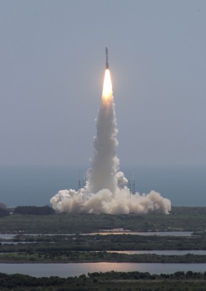
Juno soars skyward to Jupiter on Aug. 5, 2011 from launch pad 41 at Cape Canaveral Air Force Station at 12:25 p.m. EDT. View from the VAB roof. Credit: Ken Kremer/kenkremer.com
Juno launched atop an Atlas V rocket two years ago from Cape Canaveral Air Force Station, FL, on Aug. 5, 2011 on a journey to discover the genesis of Jupiter hidden deep inside the planet’s interior.

During a one year long science mission – entailing 33 orbits lasting 11 days each – the probe will plunge to within about 3000 miles of the turbulent cloud tops and collect unprecedented new data that will unveil the hidden inner secrets of Jupiter’s origin and evolution.

NBC News has also featured this Juno story – here

Read more about Juno’s flyby in my articles – here and here

Stay tuned here for continuing Juno, LADEE, MAVEN and more up-to-date NASA news.

Ken Kremer