This is a picture of the sequence of the eight planets and three of the dwarf planets. Image courtesy of IAU.
[/caption]
Since 2006, due to a controversial decision by the International Astronomical Union (IAU) that demoted Pluto to a dwarf planet, we have had eight planets.
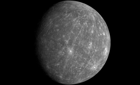
Mercury is a small planet, which can reach extreme temperatures. Since the planet is the closest one to the Sun, it can reach temperatures of 450°C. However, because the planet has almost no atmosphere due to very little gravity, the surface also drops to low temperatures of -170°C.
Venus is farther from the Sun than Mercury is, but it stays hotter due to its thick, toxic atmosphere. The main compound in Venus’ atmosphere is carbon dioxide, which creates the strongest greenhouse effect of any planet.
Undoubtedly, you already know a lot about Earth, but you may not know that our planet is the only one in our Solar System that has plate tectonics. The Earth’s outer crust is broken up into various sections called plates, which can move. These plates also take carbon out of the atmosphere and recycle it. This prevents a greenhouse effect like Venus’ and keeps the Earth from getting too hot. This is just one feature of our unique planet that helps support life.
Mars is the only inner planet, except for Earth, that has moons. Its two moons are called Phobos and Deimos. In Greek mythology, Phobos is a son of Ares (the equivalent of Mars) and Deimos is a figure that represents dread.
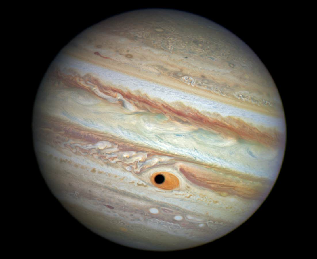
Jupiter is the model for gas giants as well as being the largest planet in our Solar System. It was named after the Roman king of the gods who was also the god of the sky and of thunder, which is fitting considering its size. Jupiter has 63 moons – more than any other planet in our Solar System.
Saturn is the only planet in our Solar System that has an average density less than water. Its core is actually denser than water, but its gas atmosphere balances the heavier core. You may consider floating Saturn in water, but even if you found a planet with a large enough body of water, the gases that make up Saturn’s atmosphere would simply merge with the other planet’s atmosphere.
Uranus and Neptune both belong to a class of gas giants called ice giants because they contain higher amounts of “ices” in their atmosphere. These ices include water, ammonia, and methane.
Neptune is an ice giant with the fastest winds of any planets. These winds can reach speeds of 2,100 kilometers per hour. The planet was discovered with mathematical predictions when astronomers noticed discrepancies in Uranus’ orbit.
The symbols of the eight planets, and Pluto, Credit: insightastrology.net
In our long history of staring up at the stars, human beings have assigned various qualities, names, and symbols for all the objects they have found there. Determined to find patterns in the heavens that might shed light on life here on Earth, many of these designations ascribed behavior to the celestial bodies.
When it comes to assigning signs to the planets, astrologists and astronomers – which were entwined disciplines in the past -made sure that these particular symbols were linked to the planets’ names or their history in some way.
Consider the planet Mercury, named after the Roman god who was himself the messenger of the gods, noted for his speed and swiftness. The name was assigned to this body largely because it is the planet closest to the Sun, and which therefore has the fastest rotation period. Hence, the symbol is meant to represent Mercury’s helmet and caduceus – a herald’s staff with snakes and wings intertwined.
Mercury, as imaged by the MESSENGER spacecraft, which was named after the messenger of the gods because it has the fastest orbit around the Sun. Image Credit: NASA/JHU/Carnegie Institution.
Venus:
Venus’ symbol has more than one meaning. Not only is it the sign for “female”, but it also represents the goddess Venus’ hand mirror. This representation of femininity makes sense considering Venus was the goddess of love and beauty. The symbol is also the chemical sign for copper; since copper was used to make mirrors in ancient times.
Earth:
Earth’s sign also has a variety of meanings, although it does not refer to a mythological god. The most popular view is that the circle with a cross in the middle represents the four main compass points. It has also been interpreted as the Globus Cruciger, an old Christian symbol for Christ’s reign on Earth.
This symbol is not just limited to Christianity though, and has been used in various culture around the world. These include, but are not limited to, Norse mythology (where it appears as the Solar or Odin’s Cross), Native American cultures (where it typically represented the four spirits of direction and the four sacred elements), the Celtic Cross, the Greek Cross, and the Egyptian Ankh.
In fact, perhaps owing to the simplicity of the design, cross-shaped incisions have made appearances as petroglyphs in European cult caves dating all the way back to the beginning of the Upper Paleolithic, and throughout prehistory to the Iron Age.
Mars, as photographed with the Mars Global Surveyor, is identified with the Roman god of war. Credit: NASA
Mars:
Mars is named after the Roman god of war, owing perhaps to the planet’s reddish hue, which gives it the color of blood. For this reason, the symbol associated with Mars represents the god of wars’ shield and spear. Additionally, it is the same sign as the one used to represent “male”, and hence is associated with self-assertion, aggression, sexuality, energy, strength, ambition and impulsiveness.
Jupiter:
Jupiter’s sign, which looks like an ornate, oddly shaped “four,” also stands for a number of symbols. It has been said to represent an eagle, which is Jupiter’s bird. Additionally, the symbol can stand for a “Z,” which is the first letter of Zeus – who was Jupiter’s Greek counterpart.
The line through the symbol is consistent with this, since it would indicate that it was an abbreviation for Zeus’ name. And last, but not least, there is the addition of the swirled line which is believed to represent a lighting bolt – which just happens to Jupiter’s (and Zeus’) weapon of choice.
Saturn:
Like Jupiter, Saturn resembles another recognizable character – this time, it’s an “h.” However, this symbol is actually supposed to represent Saturn’s scythe or sickle, because Saturn is named after the Roman god of agriculture.
Jupiter, the largest planet in the Solar System, is appropriately named after the Roman father of the gods. Credit: NASA/ESA/A. Simon (Goddard Space Flight Center)
Uranus:
The sign for Uranus is a combination of two other signs – Mars’ sign and the symbol of the Sun – because the planet is connected to these two in mythology. Uranus represented heaven in Roman mythology, and this ancient civilization believed that the Sun’s light and Mars’ power ruled the heavens.
Neptune:
Neptune’s sign is linked to the sea god Neptune, who the planet was named after. Appropriately, the symbol represents this planet is in the shape of the sea god’s trident.
Pluto:
Although Pluto was demoted to a dwarf planet, it still has a symbol. Pluto’s sign is a combination of a “P” and a “L,” which are the first two letters in Pluto as well as the initials of Percival Lowell, the astronomer who discovered the planet.
Other Objects:
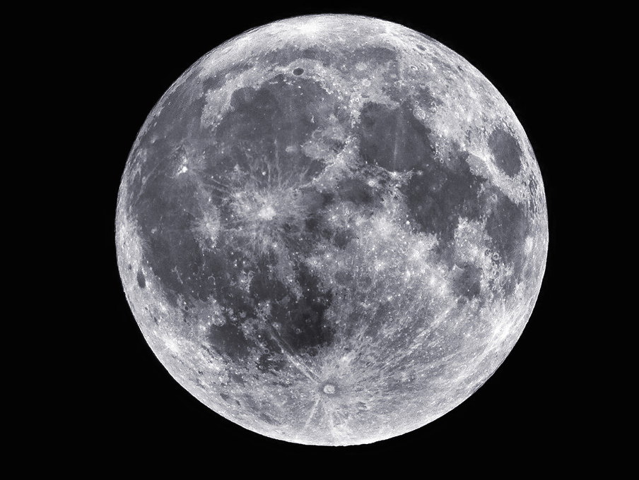
The Moon is represented by a crescent shape, which is a clear allusion to how the Moon appears in the night sky more often than not. Since the Moon is also tied to people’s perceptions, moods, and emotional make-up, the symbol has also come to represents the mind’s receptivity.
A full moon captured July 18, 2008. Credit: NASA/Sean Smith
And then there’s the sun, which is represented by a circle with a dot in the middle. In the case of the Sun, this symbol represents the divine spirit (circle) surrounding the seed of potential, which is a direct association with ancient Sun worship and the central role Sun god’s played in ancient pantheons.
The planets have played an important role in the culture and astrological systems of every human culture. Because of this, the symbols, names, and terms that denote them continue to hold special significance in our hearts and minds.
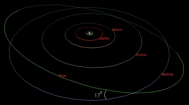
Take a look at the Solar System from above, and you can see that the planets make nice circular orbits around the Sun. But dwarf planet’s Pluto’s orbit is very different. It’s highly elliptical, traveling around the Sun in a squashed circle. And Pluto’s orbit is highly inclined, traveling at an angle of 17-degrees. This strange orbit gives Pluto some unusual characteristics, sometimes bringing it within the orbit of Neptune. Credit: NASA
[/caption]
Centuries ago, people believed that the Earth was the center of the Solar System. Slowly, that view was replaced with the heliocentric view. With that change came the realization that the planets orbit the Sun.
When Pluto was reclassified as a dwarf planet, Mercury became the planet with the most eccentric orbit. The eccentricity of an orbit is a measurement of how much the orbit deviates from a circular shape. If an orbit is a perfect circle, it has an eccentricity of zero, and that number increases with an increase in eccentricity. Mercury has an eccentricity of .21. Its orbit ranges from 46 million kilometers at the closest point to the Sun to 70 million kilometers at the farthest point. The closest point to the Sun in an orbit is called the perihelion, and the farthest point is the aphelion. Mercury is the fastest planet to orbit the Sun at approximately Earth 88 days.
Venus has the least eccentricity of any planet in our Solar System – eccentricity of .007 – with a nearly perfect circular orbit. Venus’ orbit ranges from 107 million kilometers at the perihelion to 109 million kilometers from the Sun. It takes 224.7 of our days to orbit the Sun. A day on Venus is actually longer than a year because the planet rotates so slowly. Seen from the Sun’s north pole, all of the planets rotate counter-clockwise, but Venus actually rotates clockwise; it is the only planet to do that.
Earth also has a very low eccentricity of .017. On average, the planet is about 150 million kilometers from the Sun, but it can range from 147 million kilometers to 152 million kilometers. It takes our planet roughly 365.256 days to orbit the Sun, which is the reason for leap years.
Mars has an eccentricity of .093 making it one of the most eccentric orbits in our Solar System. Mars perihelion is 207 million kilometers and its aphelion is 249 million kilometers from the Sun. Over time, Mars’ orbit has become more eccentric. It takes 687 Earth days to orbit the Sun.
Jupiter has an eccentricity of .048 with a perihelion of 741 million kilometers and an aphelion of 778 million kilometers. It takes 4331 Earth days – 11.86 of our years – for Jupiter to orbit the Sun.
Saturn has an eccentricity of .056. At its closest point, Saturn is 1.35 billion kilometers from the Sun, and 1.51 billion kilometers away at its farthest point. Depending on what position it is in its orbit, Saturn’s rings are fully visible or almost invisible. The planet takes 29.7 years to orbit the Sun. In fact, since it was discovered in 1610, Saturn has only orbited approximately 13 times. Earth has orbited the Sun almost 400 times since then.
Uranus has a perihelion of 2.75 billion kilometers and an aphelion of 3 billion kilometers from the Sun. Its eccentricity is .047. It takes Uranus 84.3 Earth years to orbit the Sun. Uranus is unique because it actually rotates on its side with an axial tilt of almost 99°.
Neptune’s eccentricity is .009, almost as low as Venus’. The planet has a perihelion of 4.45 billion kilometers and an aphelion of 4.55 billion kilometers. Since Pluto was reclassified as a dwarf planet, Neptune is the planet with an orbit farthest from the Sun.
Universe Today has articles on orbits of all the planets including Mercury and Mars.
It is often difficult to grasp just how large the planets actually are. There are a number of ways to measure a planet, including diameter, volume, and surface area.
Mercury is the smallest planet in our Solar System since Pluto was demoted to a dwarf planet. It has a diameter of 4,879 km, and a surface area of 17.48 x 10⁷ km2, which is only about 11% of Earth’s surface area. Mercury’s volume is even smaller in comparison at 6.083 x 10¹⁰ km3, which is only 5.4% the volume of Earth.
Venus is similar in size to Earth, which earned it the title of Earth’s twin. Venus has a diameter of 12,100 km and a surface area of 4.6 x 10⁸ km2. These measurements are 95% and 90% of Earth’s diameter and surface area respectively. With a volume of 9.38 x 10¹¹ km3, Venus’ volume is 86% of Earth’s.
Earth has a diameter of 12,742 km and a surface area of 5.1 x 10⁸ km2. Its volume of 1.08 x 10¹² km3 gives the planet the largest volume of any of the terrestrial planets.
Mars is also a small planet, the second smallest in our Solar System. Mars’ diameter is 6,792 km, only about 53% of Earth’s diameter. At only 28% of Earth’s surface area, Mars has a very small surface area of 1.45 x 10⁸ km2. Mars’ volume of 1.63 x 10¹¹ km3 is only 15% of Earth’s volume.
All of the gas giants are larger in size than the four inner planets. Jupiter is the largest planet in our Solar System. It has a diameter of 143,000 km, which is more than 11 times the size of Earth’s diameter. The numbers only get larger from there. Jupiter has a surface area of 6.22 x 10¹⁰ km2. That is 122 times greater than Earth’s surface area. Jupiter’s volume of 1.43 x 10¹⁵ km3 is an incredible number. You can fit 1321 Earths inside Jupiter.
Saturn is the second largest planet in our Solar System. It has a diameter of 120,536 km across the equator, and a surface area of 4.27 x 10¹⁰ km2. With a volume of 8.27 x 10¹⁴ km3, Saturn can hold 764 Earths inside.
Uranus has a diameter of 51,118 km and a surface area of 8.1 x 10⁹ km2. Although Uranus is much smaller than Jupiter, it is still large. With a volume of 6.83 x 10¹³ km3, you could fit 63 Earths inside the gas giant.
Neptune is slightly smaller than Uranus, but still very large. The planet has a diameter of 49,500 km. You could fit 57.7 Earths inside Neptune, which has a volume of 6.25 x10¹³ km3. Neptune has a surface area of 7.64 x 10⁹ km2, which is 15 times Earth’s surface area.
Planets and other objects in our Solar System. Credit: NASA.
[/caption]
Many children, and even adults, dream of visiting other planets and wonder what it would be like to stand on another planet. For one thing, your weight would be different on another planet, depending on a number of factors including the mass of the planet and how far you are away from the center of the planet.
Before we start, it’s important to understand that the kilogram is actually a measurement of your mass. And your mass doesn’t change when you go anywhere in the Universe and experience different amounts of gravity. Your weight is best measured in newtons. But since your bathroom doesn’t measure your weight in newtons, we’ll use kilograms. This is what your bathroom scale would say if you stepped on another world.
Mercury is the smallest planet in our Solar System, but it is dense. Because Mercury is so small, it has very little gravity. If you weighed 68 kg on Earth, you would only weigh 25.7 kg on Mercury.
Venus is very close to Earth in size and mass. Venus’ mass is roughly 90% of the mass of the Earth. Thus, it is no surprise that someone would weigh a similar amount on Venus. Someone who weighed 68 kg on Earth would weigh 61.6 kg on Venus.
Mars is quite a bit smaller than Earth with only 11% of our planet’s mass. Mars is larger than Mercury, but it is not as dense as the smaller planet. If you weighed 68 kg on Earth then you would weigh 25.6 kg on Mars. Since Pluto was demoted to a dwarf planet, Mars became the planet where you would weigh the least.
Jupiter is the largest planet in our Solar System with the most mass. Because of Jupiter’s mass, you would weigh more on that planet than on any other one in our Solar System. If you weighed 68 kg on Earth then you would weigh 160.7 kg on Jupiter, over twice your normal weight. That is if you could actually stand on Jupiter’s surface, which is impossible because it is a gas giant, and gas giants do not have solid surfaces.
Saturn is a gas giant best known for its planetary rings system. It is also the second biggest planet in our Solar System. Despite its mass though, the planet has a very low density and a lower gravity than Earth. If you weighed 68 kg on Earth, you would weigh 72.3 kg on Saturn.
Uranus is a gas giant without a solid surface. Although Uranus is larger in size than Neptune, it has less mass and therefore less gravity. You would only weigh 60.4 kg on Uranus, if you weighed 68 kg on Earth.
Neptune, the last planet in our Solar System, is a gas giant. If you weighed 68 kg on Earth, then you would weigh 76.5 kg on Neptune if you could stand on the planet’s surface.
Although the Moon is not a planet, it is one of the few objects that astronauts have actually visited. Because the Moon is so small, it has a low density and low gravity. If you weighed 68 kg on Earth, then you would only weigh 11.2 kg on the Moon.
[/caption]
We actually only know the exact date of when a few of the planets were discovered. Five of the planets, not including Earth, have been known to exist for thousands of years – Mercury, Mars, Venus, Jupiter, and Saturn. The Ancient Greeks and Romans wrote about the planets many centuries ago. Because the planets look like stars to the naked eye, that is where the term planets comes from. Because the planets move in the sky, they were termed wandering stars. The term planet comes from the Greek word for wanderer, “planetes.” Many ancient people thought that the planets were gods, so they gave them the names of their gods. All of the planets, except Earth have names of Roman deities.
The other three planets – Uranus, Neptune, and Pluto – were not discovered until at least the 1700’s. Pluto is no longer a planet since it was reclassified as a dwarf planet in 2006. It was known as the ninth planet for 70 years though, so its discovery will be included here. Uranus was discovered in 1781 by the famous astronomer Sir William Herschel, although that was not the first sighting of it. The planet had been sighted as early as 1690 by the English astronomer John Flamsteed. It was also sighted by Pierre Lemonier in the mid 1700’s. Sir Herschel at first thought that Uranus was a comet, but he noticed the irregularities early on and compared it to a planet in his notes.
Because Neptune cannot be seen without the help of a telescope, it was not discovered until after 1610, when Galileo created the telescope. Alexis Bouvard, a mathematician, saw that another planet had to be affecting Uranus’ orbit, so astronomers started looking for it. Two astronomers, John Couch Adams and Urbain Le Verrier, discovered Neptune independently or rather made the calculations and determined where Neptune could be found. The planet turned out to be 1° from Verrier’s calculations and 12° from Adams’. There was a dispute between France and England over who discovered the new planet because Adams and Verrier are from England and France respectively.
Pluto was the last planet discovered, although that distinction returned to Neptune when Pluto was reclassified as a dwarf planet. Pluto was discovered in 1930 by the astronomer Clyde Tombaugh. Many people had been searching for a ninth planet – the elusive planet X – for quite a while. Since Pluto was discovered near the calculated location of planet X, they thought the two planets were one and the same. Later, astronomers realized that there was no such planet X.
Planets and other objects in our Solar System. Credit: NASA.
[/caption]
You may recognize the names of the planets from your high school literature course or a history class. That is because many of the planets were first discovered by ancient civilizations, and so planets are named after their gods.
The Romans named Mercury after the messenger of the gods because it appears to move so quickly.
Venus was named after the Roman goddess of love because of its shining presence. The planet is the brightest object in the sky beside the Moon and the Sun. A number of other cultures also named Venus after their own gods or goddesses of love and war.
Earth is the only planet not named after a god. The name is based on Germanic and Old English words for “ground.”
Mars was named after the Roman god of war because of its red color, which reminded people of blood. Other civilizations also had names for the planet based on its color. The Egyptians called it “Her Desher,” which means “the red one.”
Jupiter was named after the king of the gods – Zeus by the Greeks and Jupiter by the Romans. Ancient civilizations most likely named this planet after the most powerful god because of its size. Jupiter is the largest and most massive planet in our Solar System.
Saturn was named after the father of the king of gods as well as being the god of agriculture and harvest. In mythology, Saturn had taken the position of king of the gods from his own father, Uranus, and then Jupiter overthrew him. Saturn is the last planet that can be seen from Earth without the aid of a telescope.
Uranus was not discovered until 1781 by Sir William Herschel, so it was not necessarily going to be named after a Roman god. In fact, Herschel named the planet “Georgium Sidus” in honor of George III who was King of England at the time. Others called the planet Herschel in honor of the astronomer who had discovered it. The name Uranus, which is the name of the Roman god who is the father of Jupiter, was suggested by the astronomer Johann Bode. That name was widely accepted in the mid 1800’s, and it fit in with the other planets, which all had names from mythology.
Neptune had been observed by a number of astronomers, but they believed it was a star. Two people, John Couch Adams and Urban Le Verrier, calculated the planet’s location. Johann Galle, the astronomer who discovered the planet using Verrier’s calculations, wanted to name the planet after Verrier. Many astronomers objected though, so it was named after Neptune the Roman god of the sea. The name was very fitting because the planet is a bright sea blue.
In elementary school, every teacher had one of those pull-down maps of the world to teach geography. On occasion, I thought the largest land masses, known as continents, reminded me of pieces in a jigsaw puzzle. They just seemed like they should fit together, somehow. Not until I took Earth Science, in 8TH grade, did I discover my earlier idea was correct. My teacher explained about a phenomenon, known as, The Continental Drift Theory. He said that some German had the same idea I did.
The man my teacher mentioned, Alfred Wegener (Vay gen ner), developed The Continental Drift Theory in 1915. He was a meteorolgist and a geologist. His theory basically said that, at one time, there existed one large supercontinent, called, Pangea, pan, meaning all-encompassing, and, gea, meaning the Earth. He went on to suggest that, seismic activity, such as erthquakes, volcanic eruptions, and tsunamis, also called tidal waves, eventually created fissures, or cracks in the Earth. As these fissures became larger, longer, and deeper, 7 pieces of Pangea broke off and, over time, drifted to the places where they are now. These 7 large pieces of land are what we now call, continents. They are: North America; South America; Europe; Asia; Africa; Antarctica; and, Australia. Some people refer to the country as Australia, and the continent as, Oceania. They do this because there are other countries, such as New Zealand, included as a part of that particular continent.
At the time, people thought Wegener was, well, “nuts.” Only in the 1950s did people begin to take his idea seriously. According to the United States Geological Survey (the USGS), thanks to the use of the submarine and the technology developed during World War II, scientists learned a lot about the Ocean Floor. When they found out that it was not as old as the Crust, or Surface, of the Earth, sicentists had to ask themselves, “Why?”
The answers have to do with earthquakes, volcanoes, and magnetism. When the Earth cracks, molten magma, from the middle of the Earth, known as the Mantle, works its way to the surface, where it becomes known as, lava. That lava melts away some of the older layers; then, when the water cools that lava, it forms a new layer of Earth. For that reason, if scientists tried to determine the age of the Earth from samples taken from the Ocean Floor, they would be very wrong.
That same equipment also helped scientists recognize that heavy amounts of basalt, a volcanic rock that contains high amounts of iron, could throw compasses off course. This information provided one more pieces to the puzzle. Now, scientists recognize that the North and South Poles were not always where they currently are.
The Earth changes every day. Although we might not notice it, the continents move all the time. We don’t only revolve, or spin, around the Sun. We also drift across the surface of the planet.
[/caption]
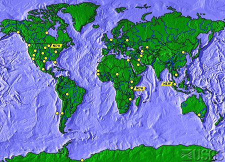
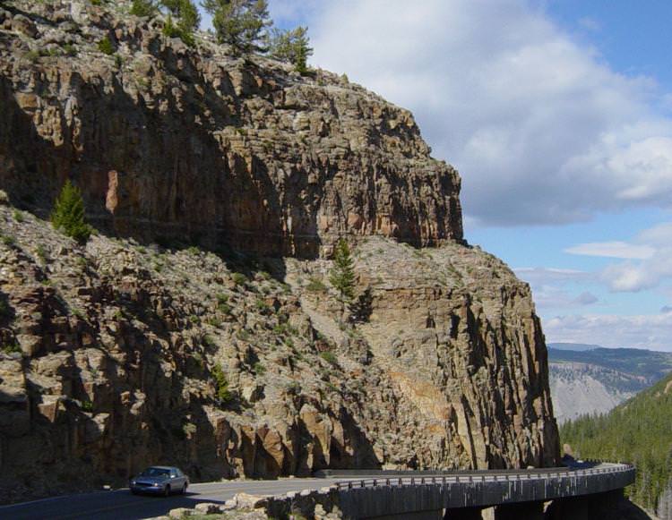
Millions of people visit Yellowstone National Park every year, but how many think about the fact that they’re standing on top of one of the largest volcano calderas on Earth? Within the last 17 million years, there have been more than 100 large eruptions within the Yellowstone caldera, and thousands of smaller lava flows and steam explosions. In fact, the last great Yellowstone eruption happened about 70,000 years ago, and it only seems like a matter of time before it all happens again. Don’t panic, though, geologists monitor Yellowstone carefully, and they don’t think any large eruptions will happen soon.
The Yellowstone calderas measures 55 km wide by 72 km long, and rises to an elevation of 3,142 meters at its tallest point – Mount Sheridan. The constant uprise of the region created a plateau where there used to be a mountain range. These eruptions and uplift helped create the eastern Snake River Plain.
In the last 17 million years, there have been 142 caldera-forming eruptions in Yellowstone. This is an eruption large enough that a significant amount of lava, ash or rock were released – usually as an explosive eruption. Three of these eruptions have been classified as “super eruptions”, where up to 2,500 cubic km of ash and rock exploded out of the volcano. Just for comparison, Mount St. Helens, which erupted in 1980, only released 1 cubic km of material… so 2,500 times that in a single eruption. One of these super eruptions would have devastated most of North America, and cooled the climate of planet Earth for decades. The oldest of these Yellowstone eruptions happened 2.1 million years ago, which created the Huckleberry Ridge Tuff. The next oldest happened 1.3 million years ago, and the most recent super eruption happened about 640,000 years ago.
And since that last super eruption, there have been numerous smaller (but still powerful eruptions) non-explosive eruptions. The most recent lava flow has been estimated to have occurred about 70,000 years ago, and a steam explosion created a 5-km crater 13,800 years ago. The only eruptions that happen at Yellowstone today are the numerous geothermal vents around the caldera. These mix with water to create the famous geysers, like Old Faithful. These geysers indicate that Yellowstone is still a very active region, and more eruptions are likely.
Geologists are continuing to monitor the Yellowstone caldera, including the speed at this the caldera floor is rising up. Like Hawaii, Yellowstone is created by a single volcanic hotspot located under the Earth. The North American Plate is slowly moving over top of the hotspot, creating a long chain of calderas. The current caldera in Wyoming is the current location of the hotspot. Geologists have measured that the caldera floor is rising upwards at almost 7 cm per year. Fortunately, they find no evidence that we’re due for another super Yellowstone eruption. Of course, these things are difficult to predict.
The circumference of the Earth in kilometers is 40,075 km, and the circumference of the Earth in miles is 24,901. In other words, if you could drive your car around the equator of the Earth (yes, even over the oceans), you’d put on an extra 40,075 km on the odometer. It would take you almost 17 days driving at 100 km/hour, 24 hours a day to complete that journey.
If you like, you can calculate the Earth’s circumference yourself. The formula for calculating the circumference of a sphere is 2 x pi x radius. So, the radius of the Earth is 6371 km. Plug that into the formula, and you get 2 x 3.1415 x 6378.1 = 40,074. It would be more accurate if you use more digits for pi.
You might be interested to know that the circumference of the Earth is different depending on how you measure it. If you measure the circumference around the Earth’s equator, you get the 40,075 km figure I mentioned up to. But if you measure it from pole to pole, you get 40,007 km. This is because the Earth isn’t a perfect sphere; it bulges around the equator because it’s rotating on its axis. The Earth is a flattened sphere, and so the distance around the equator is further than the circumference around the poles.
Want some comparison? The circumference of the Moon is 10,921 km, and the circumference of Jupiter is 500,000 km.
Here are a bunch of measurements for you:
Circumference of the Earth in kilometers: 40,075 km
Circumference of the Earth in meters: 40,075,000 meters
Circumference of the Earth in centimeters: 4,007,500,000 centimeters
Circumference of the Earth in miles: 24,901 miles
Circumference of the Earth in feet: 131,477,280 feet
Circumference of the Earth in inches: 1,577,727,360 inches