An Enormous Arctic Spiral

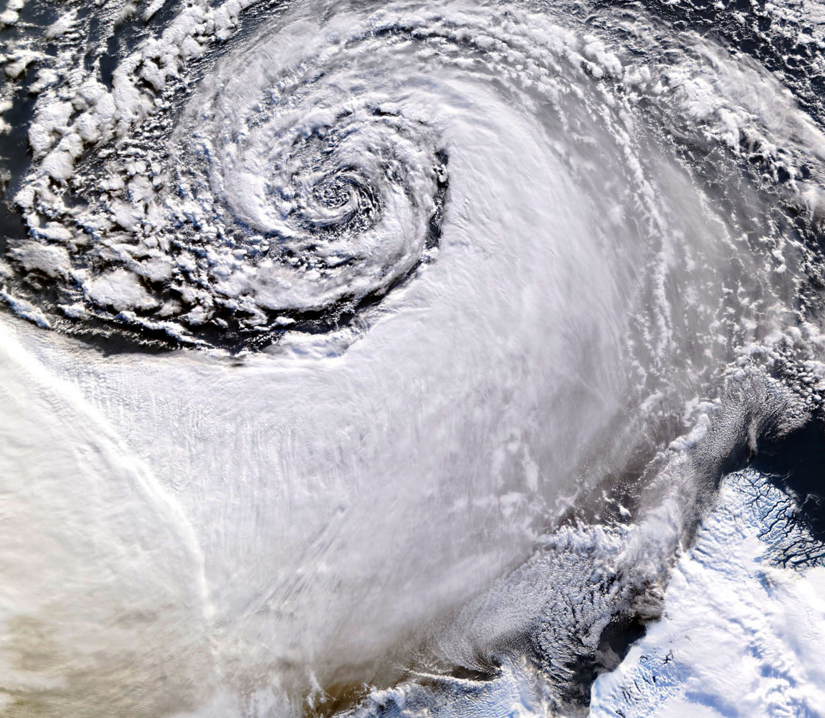
Satellite image of a cloud vortex off the coast of Greenland (NASA/MODIS/Chelys)

Looking south across the southern tip of Greenland, this satellite image shows an enormous cloud vortex spiraling over the northern Atlantic ocean on January 26, 2013. An example of the powerful convection currents in the upper latitudes, these polar low cyclones are created when the motion of cold air is energized by the warmer ocean water beneath.

Sometimes referred to as Arctic cyclones, these spiraling storms can bring gale-force winds and heavy snowfall over a wide area of ocean during their 12- to 36-hour lifespans. Hurricane-type storms don’t only form in the tropics!

This image was captured by the MODIS instrument on NASA’s Aqua satellite from its polar orbit 705 km (438 miles) above the Earth. The view has been rotated so south is up; the southernmost tip of Greenland can be seen at lower right. Click for an impressive high-resolution view.

Image via EOSNAP/Chelys

NASA Satellite Sees Ghostly Remains of Vanishing Arctic Sea Ice

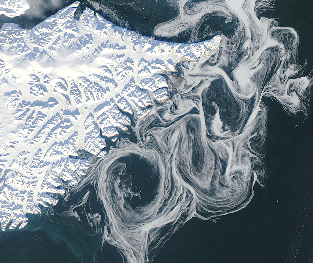
Sea ice swirls in ocean currents off the coast of Greenland (NASA/GSFC)

Spooky spectral swirls of last season’s sea ice drift in currents off the coast of eastern Greenland in this image from NASA’s Aqua satellite, acquired on October 17. Although sea ice in the Arctic will start forming again after September’s record low measurements, these ghostly wisps are likely made up of already-existing ice that has migrated south.

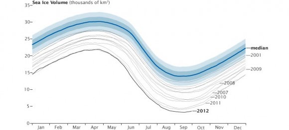
As global temperatures rise — both over land and in the ocean — thinner sea ice builds up during the Arctic winter and thus more of it melts during the summer, a pattern that will eventually lead to an ice-free Arctic if trends continue. The past several years saw sea ice in the Arctic below the 1979-2000 average, with this past September displaying the lowest volumes yet recorded.

The graph below, made from data modeled by the Polar Science Center at the University of Washington, show the chilling — or, perhaps, not-so-chilling — results of this century’s recent observations.

Along Greenland’s east coast, the Fram Strait serves as an expressway for sea ice moving out of the Arctic Ocean. The movement of ice through the strait used to be offset by the growth of ice in the Beaufort Gyre.

Until the late 1990s, ice would persist in the gyre for years, growing thicker and more resistant to melt. Since the start of the twenty-first century, however, ice has been less likely to survive its trip through the southern part of the Beaufort Gyre. As a result, less Arctic sea ice has been able to pile up and form multi-year ice.

Thin, free-drifting ice — as seen above — moves very easily with winds and currents.

Aqua is a NASA Earth Science satellite mission named for the large amount of information that the mission is collecting about the Earth’s water cycle, including evaporation from the oceans, water vapor in the atmosphere, clouds, precipitation, soil moisture, sea ice, land ice, and snow cover on the land and ice. Aqua was launched on May 4, 2002, and carries six Earth-observing instruments in a near-polar low-Earth orbit. MODIS, which acquired the image above, is a 36-band spectroradiometer that measures physical properties of the atmosphere, oceans and land.

Source: NASA Earth Observatory

NASA image courtesy Jeff Schmaltz, LANCE MODIS Rapid Response Team at NASA GSFC. Graph by Jesse Allen based on modeled ice volume data from the Polar Science Center, University of Washington. Caption portions by Michon Scott with information from Ted Scambos, National Snow and Ice Data Center.

Greenland Glacier Calves Another Huge Ice Island

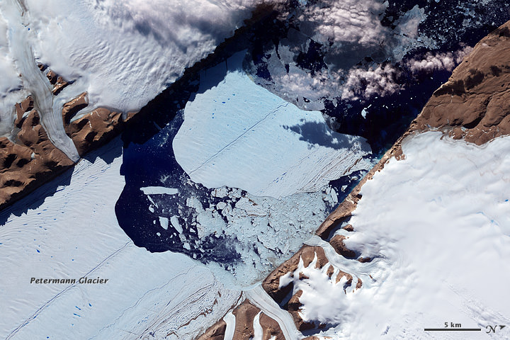
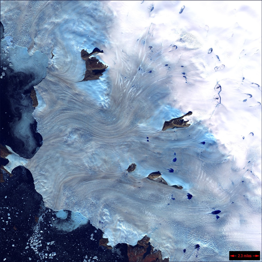
Petermann glacier, a 70 km (43 mile) long tongue of ice that flows into the Arctic Ocean in northwest Greenland, recently calved an “ice island” approximately 130 square kilometers (50 sq. miles) — about twice the area of Manhattan. The image above, acquired by NASA’s Terra satellite, shows the ice island as it drifts toward the ocean five days after breaking off the main glacier.

Petermann glacier has been known for birthing massive ice islands; previously in August 2010 an even larger island broke away from the glacier, measuring 251 square kilometers (97 sq. miles). That slab of ice eventually drifted into the northern Atlantic and was even visible from the Space Station a year later!

Read: Manhattan-Sized Ice Island Seen From Space

Although some of Greenland’s glaciers have been observed to be quickening their seaward pace as a result of global warming, this particular calving event — which occurred along a crack that appeared in 2001 satellite imagery — isn’t thought to be a direct result of climate but rather of ocean currents and isn’t expected to have any significant effect on the rate of Greenland’s ice loss as a whole. Still, satellite observation of such events provides valuable data for researchers monitoring the processes that are involved with rapidly accelerating Arctic ice loss.

And if you want an idea of what a slab of ice this large looks like up close, here’s a video taken by researchers on approach to a smaller chunk of the 2011 island:

NASA Earth Observatory image by Jesse Allen, using data from NASA/GSFC/METI/ERSDAC/JAROS, and U.S./Japan ASTER Science Team. (NASA/Terra)

Oldest Impact Crater on Earth Discovered in Greenland

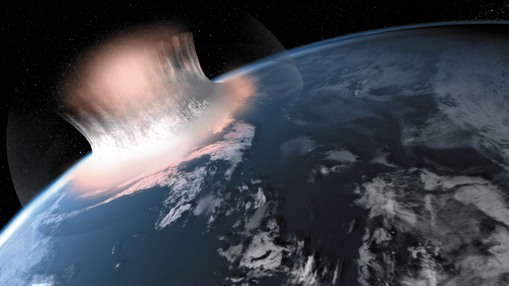
Artistic expression of large meteorite impact
An artistic expression of how a large meteorite impact into the sea might have looked in the first second of the impacting. We do not know if the area that was hit was actually covered by water or if there was just a sea nearby. Source: Carsten Egestal Thuesen, GEUS

With shifting continents, rain, and wind, finding traces of ancient impact craters on Earth has been, literally, astronomically low. Now, an international team of scientists say they have found a massive impact crater in Greenland a billion years older than other known asteroid impact on Earth.

Scientists found the remains of the giant 100-kilometer (62 mile) wide crater near the Maniitsoq region of West Greenland and they believe it’s three billion years old. The largest and previously oldest known crater is the 300 kilometer-wide Vredefort crater in South Africa. Tipped on its side, the edges of the Maniitsoq crater would extend from the surface of the Earth to the edge of space.

“This single discovery means that we can study the effects of cratering on the Earth nearly a billion years further back in time than was possible before,” according to Dr. Iain McDonald of the School of Earth and Ocean Sciences at Cardiff University, who was part of the team.

Finding the crater wasn’t an easy task. Today, the Moon still shows marks of the massive bombardment that took place between three and four billion years ago. The early Earth, with its greater gravitational attraction, would have experienced even more collisions. But the land around Maniitsoq has been eroded over the eons to expose crust that originally was 25 kilometers (16 miles) below the surface. Effects of the immense shockwave produced on impact penetrated deep into the crust and remain visible.

Evidence at that depth had never been observed before, says McDonald. “The process was rather like a Sherlock Holmes story,” said McDonald. “We eliminated the impossible in terms of any conventional terrestrial processes, and were left with a giant impact as the only explanation for all of the facts.”

Only about 180 impact craters have been discovered on Earth. Around 30 percent of them contain important natural resources, including nickel, gold, oil and natural gas. It was during an exploration of natural resources that evidence for the crater was discovered. “It has taken us nearly three years to convince our peers in the scientific community,” said McDonald. “But the mining industry was far more receptive. A Canadian exploration company has been using the impact model to explore for deposits of nickel and platinum metals at Maniitsoq since the autumn of 2011.”

The international team, led by Adam Garde, a senior research scientist at the Geological Survey of Denmark and Greenland, or GEUS, contains members from Cardiff, Lund University in Sweden, and the Institute of Planetary Science in Moscow. Their work was recently published in the jounal Earth and Planetary Science Letters.

Image caption: An artistic expression of how a large meteorite impact into the sea might have looked in the first second of the impacting. We do not know if the area that was hit was actually covered by water or if there was just a sea nearby. Source: Carsten Egestal Thuesen, GEUS

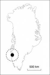
Map caption: Black circle on map shows the location of the meteorite impact structure near the town Maniitsoq in Greenland.

Read more about the Maniitsoq structure.

Scientists Set Their Sights on Arctic Ice Loss

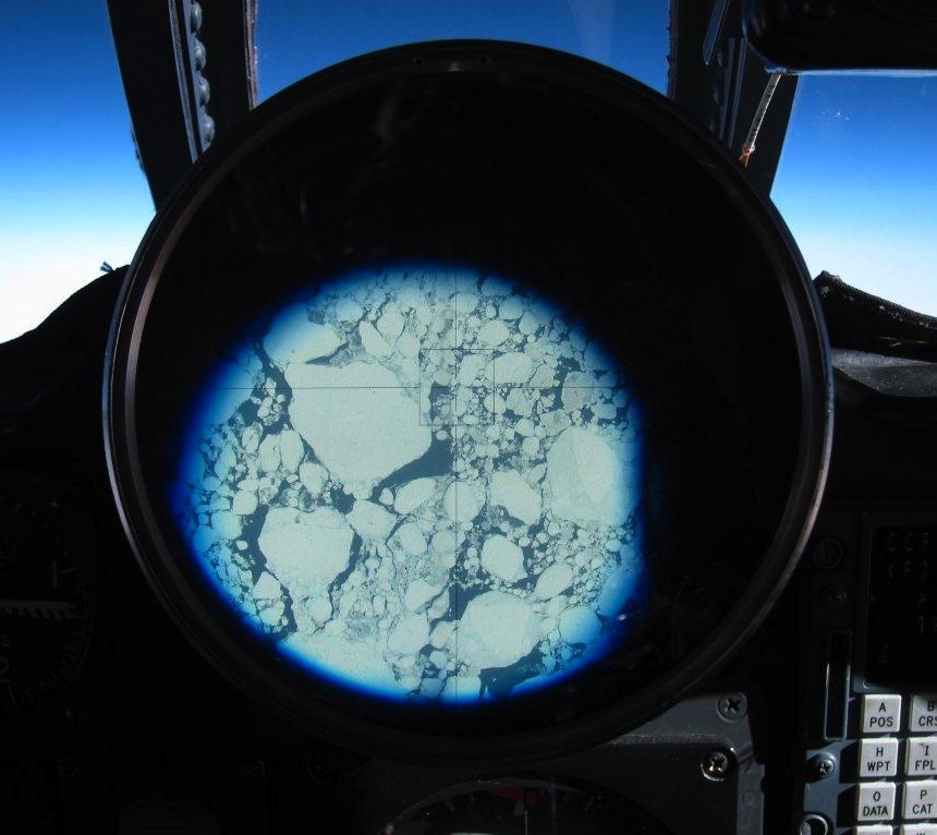
Greenland ice breakup seen from NASA ER-2 cockpit during a MABEL flight (NASA)

[/caption]

NASA researchers have just completed science mission flights over Greenland and the surrounding seas, gathering data on ice distribution and thickness with the MABEL (Multiple Altimeter Beam Experimental Lidar) laser altimeter instrument mounted in the nose of an ER-2 aircraft. WIth MABEL’s unprecedented ability to detect individual photons, researchers will be able to even more accurately determine how Arctic ice sheets are behaving in today’s changing climate.

At the same time, news has come in from researchers with the University of Washington, who have completed a NASA- and NSF-funded study of the enormous island’s glaciers spanning a ten-year period. What they have found is that the glaciers have been increasing in speed about 30% over the past ten years — which is actually less than earlier studies had anticipated.

“In some sense, this raises as many questions as it answers. It shows there’s a lot of variability,” said Ian Joughin, a glaciologist in the UW’s Applied Physics Laboratory and coauthor of the paper, published May 4 in Science.

Previous research had suggested that Greenland’s melting glaciers could contribute up to 19 inches to global sea level rise by 2100. But the behavior of Greenland’s vast ice fields and ocean-draining glaciers was not yet thoroughly researched. Based on this new study, the outlet glaciers have not sped up as much as expected.

Still, ocean-draining (a.k.a. marine-terminating) glaciers move much faster than their land-based counterparts, and the UW researchers have found that their speeds are increasing on average — up to 32% in some areas.

The team realizes that the study may just not have observed a long enough period of time. (These are glaciers, after all!)

Icebergs calve from the edge of Greenland's Gyldenlove glacier in April 2011. (NASA/GSFC/Michael Studinger)

“There’s the caveat that this 10-year time series is too short to really understand long-term behavior, so there still may be future events – tipping points – that could cause large increases in glacier speed to continue,” said Ian Howat, an assistant professor of earth sciences at Ohio State University and a co-author of the paper. “Or perhaps some of the big glaciers in the north of Greenland that haven’t yet exhibited any changes may begin to speed up, which would greatly increase the rate of sea level rise.”

What the researchers didn’t find was any evidence that the rate of flow is slowing down. Though the true extent of the effect of Greenland’s ice on future sea level rise may not be unerringly predictable down to the inch or centimeter, even at the currently observed rate a contribution of 4 or more inches by the end of the century is still very much a possibility.

Meanwhile, the data gathered from the MABEL science flights over the past four weeks will be used to calibrate NASA’s next-generation ice-observing satellite, IceSat-2, planned for launch in 2016. Once in orbit, IceSat-2 will provide even more detailed insight to the complex behavior of our planet’s ice sheets.

Read more on the UW News release here.

What Is The Largest Island In The World

Greenland. Image credit: NASA

[/caption]

If you were asked what is the largest island in the world, what would you say? Australia maybe? Greenland is the worlds largest island. While Australia is an island, it is considered a continent. Greenland has an area of 2,166,086 square km, but a meager population of 56,452. The populations is over 85% Inuit. The remaining inhabitants are mainly Danish. The average annual temperature of Greenland varies between -9 to 7 °C.

Greenland is an autonomous country within the Kingdom of Denmark. Greenland is a group of islands and Greenland is the name of the largest, most populated one. Greenland has been inhabited on and off since 2500 BC. Denmark established rule in the 18th century. In 1979 Denmark granted home rule, in a relationship known as the Commonwealth of the Realm and in 2008 Greenland voted to transfer more powers to the local government. The Danish royal government is only in charge of foreign affairs, security, financial policy, and providing a subsidy to each citizen.

Greenland is bordered by the Atlantic Ocean to the southeast, the Greenland Sea to the east, the Artic Ocean to the north, and Baffin Bay to the west. The nearest countries to Greenland are Iceland to the east and Canada to the west. The country also contains the world’s largest national park. Scientists have thought for decades that the ice sheet covering the country may actually conceal three separate island land masses that have been bridged by glaciers over the last geologic cooling period.

The Greenland ice sheet covers 1,755,637 square km. It has a volume of 2,850,000 cubic km. Gunnbjorn Fjeld is the highest point on Greenland at 3,700 m. The majority of Greenland is less than 1,500 m in elevation. The weight of the ice sheet has formed a basin that is more than 300 m below sea level.

Between 1989 and 1993, climate researchers drilled into the summit of Greenland’s ice sheet, obtaining a pair of 3 km ice cores. Analysis of the layering and chemical composition of the cores has provided a revolutionary new record of climate change going back about 100,000 years. It illustrated that the world’s weather and temperature have often shifted rapidly from one stable state to another. The glaciers of Greenland are also contributing to a rise in the global sea level at a faster rate than was previously believed.

Greenland is fascinating and intimidating at the same time. To live there is a daily struggle against the elements that has forged a tough people.

We have written many articles about Greenland for Universe Today. Here’s an article about the growing ice sheets in Greenland, and here are some images of Greenland from space.

If you’d like more info on Earth’s islands, check out NASA’s Solar System Exploration Guide on Earth. And here’s a link to NASA’s Earth Observatory.

We’ve also recorded an episode of Astronomy Cast all about planet Earth. Listen here, Episode 51: Earth.

Sources:
World Atlas
Geographia