[/caption]
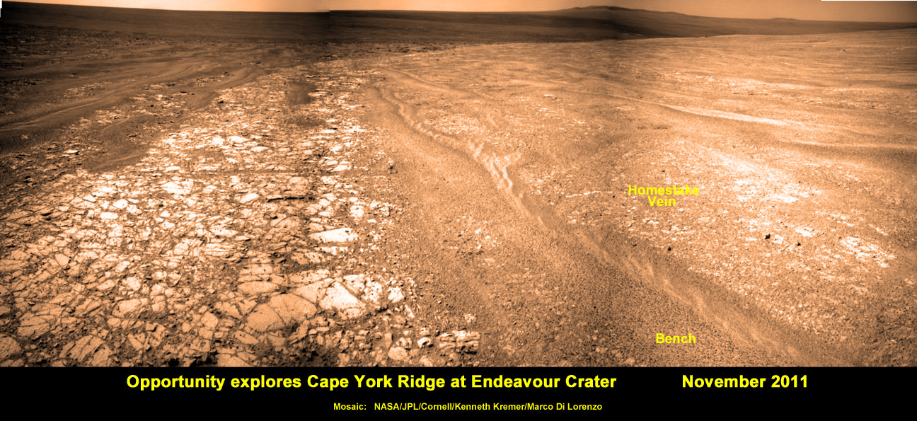
NASA’s long lived Opportunity rover has discovered the most scientifically compelling evidence yet for the flow of liquid water on ancient Mars. The startling revelation comes in the form of a bright vein of the mineral gypsum located at the foothills of an enormous crater named Endeavour, where the intrepid robot is currently traversing. See our mosaic above, illustrating the exact spot.
Update: ‘Homestake’ Opportunity Mosaic above has just been published on Astronomy Picture of the Day (APOD) – 12 Dec 2011 (by Ken Kremer and Marco Di Lorenzo)
Researchers trumpeted the significant water finding this week (Dec. 7) at the annual winter meeting of the American Geophysical Union (AGU) in San Francisco.
“This gypsum vein is the single most powerful piece of evidence for liquid water at Mars that has been discovered by the Opportunity rover,” announced Steve Squyres of Cornell University, Ithaca, N.Y., Principal Investigator for Opportunity, at an AGU press conference.
The light-toned vein is apparently composed of the mineral gypsum and was deposited as a result of precipitation from percolating pools of liquid water which flowed on the surface and subsurface of ancient Mars, billions of years ago. Liquid water is an essential prerequisite for life as we know it.
“This tells a slam-dunk story that water flowed through underground fractures in the rock,” said Squyres. “This stuff is a fairly pure chemical deposit that formed in place right where we see it. That can’t be said for other gypsum seen on Mars or for other water-related minerals Opportunity has found. It’s not uncommon on Earth, but on Mars, it’s the kind of thing that makes geologists jump out of their chairs.”
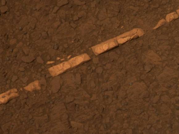
This color view of a mineral vein called "Homestake" was taken by the panoramic camera (Pancam) on NASA's Mars Exploration Rover Opportunity. The vein is about the width of a thumb and about 18 inches (45 centimeters) long. Opportunity examined it in November 2011 and found it to be rich in calcium and sulfur, possibly the calcium-sulfate mineral gypsum.
The light-toned vein is informally named “Homestake”, and was examined up close by Opportunity’s cameras and science instruments for several weeks this past month in November 2011, as the rover was driving northwards along the western edge of a ridge dubbed ‘Cape York’ – which is a low lying segment of the eroded rim of Endeavour Crater.
Veins are a geologic indication of the past flow of liquid water
Opportunity just arrived at the rim of the 14 mile (22 kilometere) wide Endeavour Crater in mid-August 2011 following an epic three year trek across treacherous dune fields from her prior investigative target at the ½ mile wide Victoria Crater.
“It’s like a whole new mission since we arrived at Cape York,” said Squyres.
‘Homestake’ is a very bright linear feature.
“The ‘Homestake’ vein is about 1 centimeter wide and 40 to 50 centimeters long,” Squyres elaborated. “It’s about the width of a human thumb.”
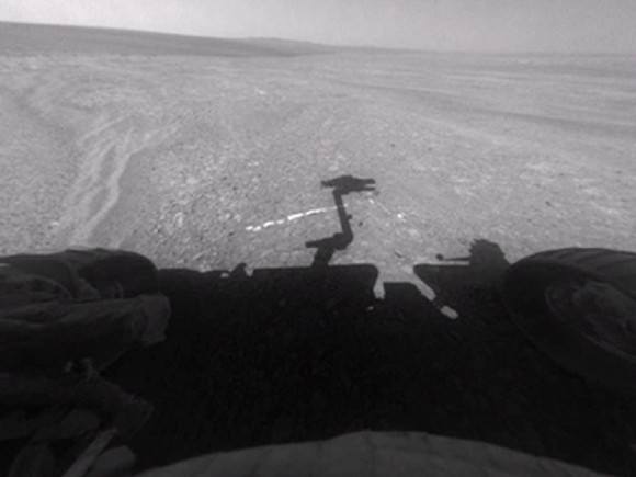
This view from the front hazard-avoidance camera on NASA's Mars Exploration Rover Opportunity shows the rover's arm's shadow falling near a bright mineral vein informally named Homestake. The vein is about the width of a thumb and about 18 inches (45 centimeters) long. Opportunity examined it in November 2011 and found it to be rich in calcium and sulfur, possibly the calcium-sulfate mineral gypsum. Opportunity took this image on Sol 2763 on Mars (Nov. 7, 2011). Credit: NASA/JPL-Caltech
Homestake protrudes slightly above the surrounding ground and bedrock and appears to be part of a system of mineral veins running inside an apron (or Bench) that in turn encircles the entire ridge dubbed Cape York.
In another first, no other veins like these have been seen by Opportunity throughout her entire 20 miles (33 kilometers) and nearly eight year long Martian journey across the cratered, pockmarked plains of Meridiani Planum, said Squyres.
The veins have also not been seen in the higher ground around the rim at Endeavour crater.
“We want to understand why these veins are in the apron but not out on the plains,” said the mission’s deputy principal investigator, Ray Arvidson, of Washington University in St. Louis. “The answer may be that rising groundwater coming from the ancient crust moved through material adjacent to Cape York and deposited gypsum, because this material would be relatively insoluble compared with either magnesium or iron sulfates.”
Opportunity was tasked to engage her Microscopic Imager and Alpha Particle X-ray Spectrometer (APXS) mounted on the terminus of the rover’s arm as well as multiple filters of the mast mounted Panoramic Camera to examine ‘Homestake’.
“The APXS spectrometer shows ’Homestake’ is chock full of Calcium and Sulfur,” Squyres gushed.
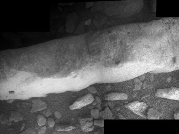
This close-up view of a mineral vein called Homestake comes from the microscopic imager on Opportunity. The vein is about the width of a thumb and about 18 inches (45 centimeters) long. Opportunity examined it in November 2011 and found it to be rich in calcium and sulfur, possibly the calcium-sulfate mineral gypsum. Homestake is near the edge of the "Cape York" segment of the western rim of Endeavour Crater. This view blends three exposures taken by the microscopic imager during the 2,765th and 2,766th Martian days, or sols, of Opportunity's career on Mars (Nov. 3 and 4, 2011). Credit: NASA/JPL-Caltech/Cornell/USGS
The measurements of composition with the APXS show that the ratio points to it being relatively pure calcium sulfate, Squyres explained. “One type of calcium sulfate is gypsum.”
Calcium sulfate can have varying amounts of water bound into the minerals crystal structure.
The rover science team believes that this form of gypsum discovered by Opportunity is the dihydrate; CaSO4•2H2O. On Earth, gypsum is used for making drywall and plaster of Paris.
The gypsum was formed in the exact spot where Opportunity found it – unlike the sulfate minerals previously discovered which were moved around by the wind and other environmental and geologic forces.
“There was a fracture in the rock, water flowed through it, gypsum was precipitated from the water. End of story,” Squyres noted. “There’s no ambiguity about this, and this is what makes it so cool.”
At Homestake we are seeing the evidence of the ground waters that flowed through the ancient Noachian rocks and the precipitation of the gypsum, which is the least soluble of the sulfates, and the other magnesium and iron sulfates which Opportunity has been driving on for the last 8 years.
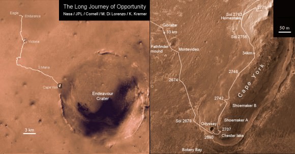
Traverse map showing the 8 Year Journey of Opportunity from Eagle Crater landing site Sol 1 (Jan. 24, 2004) to Sol 2775 (November 2011). Map shows rover location around Homestake water related mineral on Sol 2763 (November 2011) at Cape York ridge at Endeavour Crater rim. Endeavour Crater is 14 miles or 22 kilometers in diameter. Opportunity has driven more than 21 miles (34 km).
Credit: NASA/JPL/Cornell/Marco Di Lorenzo/Kenneth Kremer
“Here, both the chemistry, mineralogy, and the morphology just scream water,” Squyres exclaimed. “This is more solid than anything else that we’ve seen in the whole mission.”
It’s inconceivable that the vein is something else beside gypsum, said Squyres.
As Opportunity drove from the plains of Meridiani onto the rim of Endeavour Crater and Cape York, it crossed a geologic boundary and arrived at a much different and older region of ancient Mars.
The evidence for flowing liquid water at Endeavour crater is even more powerful than the silica deposits found by Spirit around the Home Plate volcanic feature at Gusev Crater a few years ago.
“We will look for more of these veins in the [Martian] springtime,” said Squyres.
If a bigger, fatter vein can be found, then Opportunity will be directed to grind into it with her still well functioning Rock Abrasion Tool, or RAT.
Homestake was crunched with the wheels – driving back and forth over the vein – to break it up and expose the interior. Opportunity did a triple crunch over Homestake, said Arvidson.
Homestake was found near the northern tip of Cape York, while Opportunity was scouting out a “Winter Haven” location to spend the approaching Martian winter.
Arvidson emphasized that the team wants Opportunity to be positioned on a northerly tilted slope to catch the maximum amount of the sun’s rays to keep the rover powered up for continuing science activities throughout the fast approaching Martian winter.
“Martian winter in the southern hemisphere starts on March 29, 2012. But, Solar power levels already begin dropping dramatically months before Martian winter starts,” said Alfonso Herrera to Universe Today, Herrera is a Mars rover mission manager at NASA’s Jet Propulsion Laboratory in Pasadena, Calif.
“Opportunity is in excellent health,” said Bruce Banerdt, the Project Scientist for the Mars rover mission at JPL.
“This has been a very exciting time. We’ll head back south in the springtime and have a whole bunch of things to do with a very capable robot,” Squyres concluded.
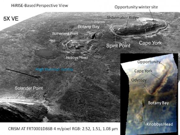
This graphic combines a perspective view of the "Botany Bay" and "Cape York" areas of the rim of Endeavour Crater on Mars, and an inset with mapping-spectrometer data. Major features are labeled. In the perspective view, the landscape's vertical dimension is exaggerated five-fold compared with horizontal dimensions. NASA's Mars Exploration Rover Opportunity examined targets in the Cape York area during the second half of 2011. The perspective view was generated by producing an elevation map from a stereo pair of images from the High Resolution Imaging Science Experiment (HiRISE) camera on NASA's Mars Reconnaissance Orbiter, then draping one of the HiRISE images over the elevation model. The inset presents data from the Compact Reconnaissance Imaging Spectrometer for Mars (CRISM) instrument on the Mars Reconnaissance Orbiter. In this CRISM observation, taken on March 29, 2011 Thermal inertia estimates from observations by the Thermal Emission Imaging System on NASA's Mars Odyssey orbiter indicate that Botany Bay is a region with extensive outcrop exposures. Credit: NASA/JPL-Caltech/UA/JHUAPL
Meanwhile, NASA’s next leap in exploring potential Martian habitats for life – the car sized Curiosity Mars Science Lab rover – is speeding towards the Red Planet.
Read Ken’s continuing features about Opportunity starting here:
NASA Robot seeks Goldmine of Science and Sun at Martian Hill along vast Crater
Opportunity spotted Exploring vast Endeavour Crater from Mars Orbit
Twin Towers 9/11 Tribute by Opportunity Mars Rover
NASA Robot arrives at ‘New’ Landing Site holding Clues to Ancient Water Flow on Mars
Opportunity Arrives at Huge Martian Crater with Superb Science and Scenic Outlook
Opportunity Snaps Gorgeous Vistas nearing the Foothills of Giant Endeavour Crater

