The Next Mars Rover’s Wheels Won’t Get Torn Apart by the Red Planet

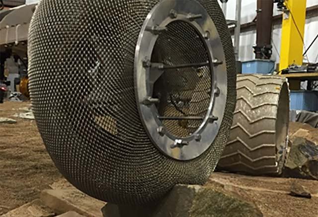
The Mars Spring Tire being tested at NASA GRS' Slope lab. Credit: NASA/JPL

The Curiosity Rover has made some incredible discoveries during the five years it has been operating on the surface of Mars. And in the course of conducting its research, the rover has also accrued some serious mileage. However, it certainly came as a surprise when during a routine examinations in 2013, members of the Curiosity science team noted that its wheels had suffered rips in their treads (followed by breaks reported in 2017).

Looking to the future, researchers at NASA’s Glenn Research Center hope to equip next-generation rovers with a new wheel. It is based on the “Spring Tire“, which NASA developed with Goodyear back in the mid-2000s. However, rather than using coiled steel wires woven into a mesh pattern (which was part of the original design) a team of NASA scientists has created a more durable and flexible version which could revolution space exploration.

When it comes right down to it, the Moon, Mars, and other bodies in the Solar System have harsh, punishing terrain. In the case of the Moon, the main issue is the regolith (aka. Moon dust) which covers the majority of its surface. This fine dust is essentially jagged bits of lunar rock which play havoc with engines and machine components. On Mars, the situation is slightly different, with regolith and sharp rocks covering most of the terrain.
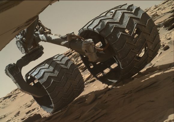
Image taken by the Mars Hand Lens Imager (MAHLI) camera showing the condition of Curiosity’s left-middle and left-rear wheels. Credit: NASA/JPL-Caltech/MSSS

In 2013, after just a year on the surface, the Curiosity rover’s wheels began to show signs of wear and tear due it traversing unexpectedly harsh terrain. This led many to worry that the rover might not be able to complete its mission. It also led many at NASA’s Glenn Research Center to reconsider a design they had been working on almost a decade prior, which was intended for renewed missions to the Moon.

For NASA Glenn, tire development has been a focus of research for about a decade now. In this respect, they are returning to a time-honored tradition of NASA engineers and scientists, which began back in the Apollo era. At the time, both the American and Russian space programs were evaluating multiple tires designs for use on the lunar surface. Overall, three major designs were proposed.

First, you had the wheels specially designed for Lunokhod rover, a Russian vehicle whose name literally translates to “Moon Walker”. The wheel design for this rover consisted of eight rigid-rim, wire-mesh tires that were connected to their axles by bicycle-type spokes. Metal cleats were also mounted on the outside of the tire to ensure better traction in the lunar dust.

Then there was NASA’s concept for a Modularized Equipment Transporter (MET), which was developed with the support of Goodyear. This unpowered cart came with two nitrogen-filled, smooth rubber tires to make it easier to pull the cart through lunar soil and over rocks. And then there was the design for the Lunar Roving Vehicle (LRV), which was the last NASA vehicle to visit the Moon.

This crewed vehicle, which Apollo astronauts used to drive around on the challenging lunar surface, relied on four large, flexible wire-mesh wheels with stiff inner frames. During the mid-2000s, when NASA began planning on mounting new missions to the Moon (and future missions to Mars), they began reevaluating the LRV tire and incorporating new materials and technologies into the design.

The fruit of this renewed research was the Spring Tire, which was the work of mechanical research engineer Vivake Asnani, who worked closely with Goodyear to develop it. The design called for an airless, compliant tire made up of hundreds of coiled steel wires, which were then woven into a flexible mesh. This not only ensured light weight, but also gave the tires the ability to support high loads while conforming to the terrain.

To see how the Spring Tire would fare on Mars, engineers at NASA’s Glenn Research Center began testing them in the Slope lab, where they ran them through an obstacle course that simulated the Martian environment. While the tires performed generally well in simulated sand, they experienced problems when the wire mesh deformed after passing over jagged rocks.

To address this, Colin Creager and Santo Padua (a NASA engineer and materials scientist, respectively) discussed possible alternatives. In time, they agreed the steel wires should be replaced with nickel titanium, a shape memory alloy that is capable of retaining its shape under tough conditions. As Padua explained in a NASA Glenn video segment, the inspiration to use this alloy was very serendipitous:

“I just happened to be over in the building here, where the Slope lab is. And I was over here for a different meeting for the work that I do in shape memory alloys, and I happen to run into Colin in the hall. And I was like ‘what are you doing back and why aren’t you over in the impact lab?’ – because I knew him as a student. He said, ‘well, I’ve graduated, and I’ve been working out here full-time for awhile… I work in Slope.”

Despite working at JPL for ten years, Padua had not seen the Slope lab before and accepted an invitation to see what they were working on. After entering the lab and looking at the Spring Tires they were testing, Padua asked if they were experiencing problems with deformation. When Creager admitted that they were, Padua proposed a solution which just happened to be his field of expertise.

“I had never even heard of the term shape memory alloys before, but I knew [Padua] was a materials science engineer,” said Creager. “And so, since then we’ve been collaborating on these tires using his materials expertise, especially in shape memory alloys, to come up with this new tire that we think is really going to revolutionize planetary rover tires and potentially even tires for Earth too.”

The key to shape memory alloys is their atomic structure, which is assembled in such a way that the material “remember” its original shape and is able to return to it after being subjected to deformation and strain. After building the shape memory alloy tire, the Glenn engineers sent it to the Jet Propulsion Laboratory, where it was tested in the Mars Life Test Facility.

Overall, the tires not only performed well in simulated Martian sand, but were able to withstand going over punishing rocky outcroppings without difficulty. Even after the tires were deformed all the way down to their axles, they were able to retain their original shape. They also managed to do this while carrying a significant payload, which is another prerequisite when developing tires for exploration vehicles and rovers.

The priorities for the Mars Spring Tire (MST) are to offer greater durability, better traction in soft sand, and lighter weight. As NASA indicates on the MST website (part of the Glenn Research Center’s website), there are three major benefits to developing high performing compliant tires like the Spring Wheel:

“First, they would allow rovers to explore greater regions of the surface than currently possible. Secondly, because they conform to the terrain and do not sink as much as rigid wheels, they can carry heavier payloads for the same given mass and volume. Lastly, because the compliant tires can absorb energy from impacts at moderate to high speeds, they can be used on crewed exploration vehicles which are expected to move at speeds significantly higher than the current Mars rovers.”

The first available opportunity to test these tires out is just a few years away, when NASA’s Mars 2020 Rover will be sent to the surface of the Red Planet. Once there, the rover will pick up where Curiosity and other rovers have left off, searching for signs of life in Mars’ harsh environment. The rover is also tasked with preparing samples that will eventually be returned to Earth by a crewed mission, which is expected to take place sometime in the 2030s.

Further Reading: NASA, CNET

NASA’s RoboSimian And Surrogate Robots

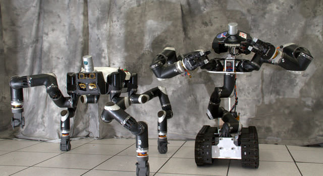
RoboSimian and Surrogate are robots that were designed and built at NASA's Jet Propulsion Laboratory in Pasadena, California. Credit: JPL-Caltech

Since they were first announced in 2012, NASA has been a major contender in the DARPA Robotics Challenge (DRC). This competition – which involves robots navigating obstacle courses using tools and vehicles – was first conceived by DARPA to see just how capable robots could be at handling disaster response.

The Finals for this challenge will be taking place on June 5th and 6th, 2015, at Fairplex in Pomona, California. And after making it this far with their RoboSimian design, NASA was faced with a difficult question. Should their robotic primate continue to represent them, or should that honor go to their recently unveiled Surrogate robot?

As the saying goes “you dance with the one who brung ya.” In short, NASA has decided to stick with RoboSimian as they advance into the final round of obstacles and tests in their bid to win the DRC and the $2 million prize.

Surrogate’s unveiling took place this past October 24th at NASA’s Jet Propulsion Laboratory in Pasadena, California. The appearance of this robot on stage, to the them song of 2001: A Space Odyssey, was held on the same day that Thomas Rosenbaum was inaugurated as the new president of the California Institute of Technology.

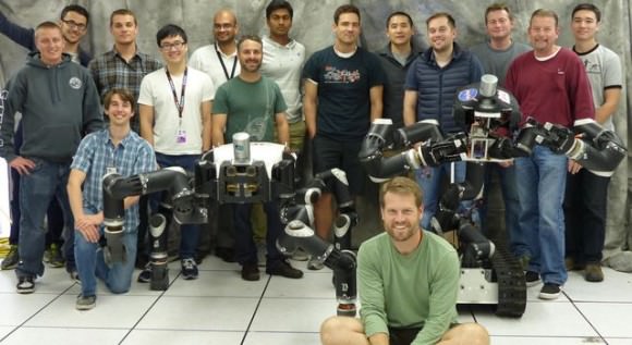
Robotics researchers at NASA's Jet Propulsion Laboratory in Pasadena, California, stand with robots RoboSimian and Surrogate, both built at JPL. Credit: JPL-Caltech
Robotics researchers at NASA’s Jet Propulsion Laboratory stand with robots RoboSimian and Surrogate, both built at JPL. Credit: JPL-Caltech

In honor of the occasion, Surrogate (aka “Surge”) strutted its way across the stage to present a digital tablet to Rosenbaum, which he used to push a button that initiated commands for NASA’s Mars rover Curiosity. Despite the festive nature of the occasion, this scene was quite calm compared to what the robot was designed for.

“Surge and its predecessor, RoboSimian, were designed to extend humanity’s reach, going into dangerous places such as a nuclear power plant during a disaster scenario such as we saw at Fukushima. They could take simple actions such as turning valves or flipping switches to stabilize the situation or mitigate further damage,” said Brett Kennedy, principal investigator for the robots at JPL.

RoboSimian was originally created for the DARPA Robotics Challenge, and during the trial round last December, the JPL team’s robot won a spot to compete in the finals, which will be held in Pomona, California, in June 2015.

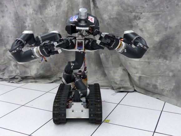
With the support of the Defense Threat Reduction Agency and the Robotics Collaborative Technology Alliance, the Surrogate robot began construction in 2014. Its designers began by incorporating some of RoboSimian’s extra limbs, and then added a wheeled base, twisty spine, an upper torso, and a head for holding sensors.

Surrogate, nicknamed "Surge," is a robot designed and built at NASA's Jet Propulsion Laboratory in Pasadena, California. Credit: JPL-Caltech
Surrogate, nicknamed “Surge,” is a robot designed and built at NASA’s Jet Propulsion Laboratory in Pasadena, California. Credit: JPL-Caltech

Additional components include a the hat-like appendage on top, which is in fact a LiDAR (Light Detection and Ranging) device. This device spins and shoots out laser beams in a 360-degree field to map the surrounding environment in 3-D.

Choosing between them was a tough call, and took the better part of the last six months. On the one hand, Surrogate was designed to be more like a human. It has an upright spine, two arms and a head, standing about 1.4 meters (4.5 feet) tall and weighing about  91 kilograms (200 pounds). Its major strength is in how it handles objects, and its flexible spine allows for extra manipulation capabilities. But the robot moves on tracks, which doesn’t allow it to move over tall objects, such as flights of stairs, ladders, rocks, and rubble.

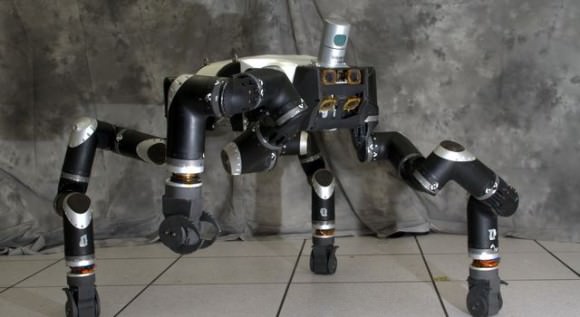
RoboSimian, by contrast, is more ape-like, moving around on four limbs. It is better suited to travel over complicated terrain and is an adept climber. In addition, Surrogate has only one set of “eyes” – two cameras that allow for stereo vision – mounted to its head, whereas RoboSimian has up to seven sets of eyes mounted all over its body.

The robots also run on almost identical computer code, and the software that plans their motion is very similar. As in a video game, each robot has an “inventory” of objects with which it can interact. Engineers have to program the robots to recognize these objects and perform pre-set actions on them, such as turning a valve or climbing over blocks.

RoboSimian is an ape-like robot that moves around on four limbs. It was designed and built at NASA's Jet Propulsion Laboratory in Pasadena, California. Credit: JPL-Caltech
RoboSimian is an ape-like robot that moves around on four limbs. It will be representing the Jet Propulsion Laboratory at the DARPA Robotics Challenge Finals in June, 2015. Credit: JPL-Caltech

In the end, they came to a decision. RoboSimian will represent the team in Pomona.

“It comes down to the fact that Surrogate is a better manipulation platform and faster on benign surfaces, but RoboSimian is an all-around solution, and we expect that the all-around solution is going to be more competitive in this case,” Kennedy said.

The RoboSimian team at JPL is collaborating with partners at the University of California, Santa Barbara, and Caltech to get the robot to walk more quickly. JPL researchers also plan to put a LiDAR on top of RoboSimian in the future. These efforts seek to improve the robot in the long-run, but are also aimed at getting it ready to face the challenges of the DARPA Robot Challenge Finals.

Specifically, it will be faced with such tasks as driving a vehicle and getting out of it, negotiating debris blocking a doorway, cutting a hole in a wall, opening a valve, and crossing a field with cinderblocks or other debris. There will also be a surprise task.

Although RoboSimian is now the focus of Kennedy’s team, Surrogate won’t be forgotten.

“We’ll continue to use it as an example of how we can take RoboSimian limbs and reconfigure them into other platforms,” Kennedy said.

For details about the DARPA Robotics Challenge, visit: http://www.theroboticschallenge.org/

Further Reading: NASA

100,000 Ice Blocks Mapped Out at the South Pole … of Enceladus

Cassini's view down into a jetting "tiger stripe" in August 2010. Credit: NASA

Ever since the Cassini space probe conducted its first flyby of Enceladus in 2005, the strange Saturnian moon has provided us with a treasure trove of images and scientific wonders. These include the jets of icy water vapor periodically bursting from its south pole, the possibility of an interior ocean – which may even harbor life – and the strange green-blue stripes located around the south pole.

Continue reading “100,000 Ice Blocks Mapped Out at the South Pole … of Enceladus”

Curiosity Brushes ‘Bonanza King’ Target Anticipating Fourth Red Planet Rock Drilling

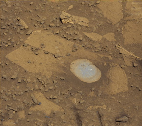
NASA’s Curiosity rover looks back to ramp with potential 4th drill site target at ‘Bonanza King’ rock outcrop in ‘Hidden Valley’ in this photo mosaic view captured on Aug. 6, 2014, Sol 711. Inset shows results of brushing on Aug. 17, Sol 722, that revealed gray patch beneath red dust. Note the rover’s partial selfie, valley walls, deep wheel tracks in the sand dunes and distant rim of Gale crater beyond the ramp. Navcam camera raw images stitched and colorized. Credit: NASA/JPL-Caltech/Ken Kremer-kenkremer.com/Marco Di Lorenzo

Curiosity brushes ‘Bonanza King’ drill target on Mars
NASA’s Curiosity rover looks back to ramp with 4th drill site target at ‘Bonanza King’ rock outcrop in ‘Hidden Valley’ in this photo mosaic view captured on Aug. 6, 2014, Sol 711. Inset shows results of brushing on Aug. 17, Sol 722, that revealed gray patch beneath red dust. Note the rover’s partial selfie, valley walls, deep wheel tracks in the sand dunes and distant rim of Gale crater beyond the ramp. Navcam camera raw images stitched and colorized.
Credit: NASA/JPL-Caltech/Ken Kremer-kenkremer.com/Marco Di Lorenzo[/caption]

Eagerly eyeing her next drill site on Mars, NASA’s Curiosity rover laid the groundwork by brushing the chosen rock target called ‘Bonanza King’ on Wednesday, Aug. 17, Sol 722, with the Dust Removal Tool (DRT) and collecting high resolution imagery with the Mast Camera (Mastcam) to confirm the success of the operation.

By brushing aside the reddish, more-oxidized dust scientists and engineers leading the mission observed a gray patch of less-oxidized rock material beneath that they anticipated seeing while evaluating the utility of ‘Bonanza King’ as the rover’s fourth candidate for Red Planet rock drilling and sampling.

To date, the 1-ton robot has drilled into three target rocks to collect sample powder for analysis by the rover’s onboard pair of the chemistry labs, SAM and CheMin, to analyze for the chemical ingredients that could support Martian microbes, if they ever existed.

Curiosity rover used the Dust Removal Tool on its robotic arm to brush aside reddish, more-oxidized dust, revealing a gray patch of less-oxidized rock material at a target called "Bonanza King," visible in this image from the rover's Mast Camera (Mastcam). Credit: NASA/JPL-Caltech/MSSS
Curiosity rover used the Dust Removal Tool on its robotic arm to brush aside reddish, more-oxidized dust, revealing a gray patch of less-oxidized rock material at a target called “Bonanza King,” visible in this image from the rover’s Mast Camera (Mastcam). Credit: NASA/JPL-Caltech/MSSS

So far everything is proceeding quite well.

The brushing activity also revealed thin, white, cross-cutting veins which is a further indication that liquid water flowed here in the distant past. Water is a prerequisite for life as we know it.

“They might be sulfate salts or another type of mineral that precipitated out of solution and filled fractures in the rock. These thin veins might be related to wider light-toned veins and features in the surrounding rock,” NASA said in a statement.

Based on these results and more from laser zapping with Curiosity’s Chemistry and Camera (ChemCam) instrument on Sol 719 (Aug. 14, 2014) the team decided to proceed ahead.

The imminent next step is to bore a shallow test hole into the brushed area which measures about about 2.5 inches (6 centimeters) across.

If all goes well with the “mini-drill” operation, the team will proceed quickly with full depth drilling to core a sample from the interior of the dinner plate sized rock slab for delivery to Curiosity’s two chemistry labs.

Bonanza King sits in a bright outcrop on the low ramp at the northeastern end of a spot leading in and out of an area called “Hidden Valley” which lies between Curiosity’s August 2012 landing site in Gale Crater and her ultimate destinations on Mount Sharp which dominates the center of the crater.

Just days ago, the rover team commanded a quick exit from “Hidden Valley” to backtrack out of the dune filled valley because of fears the six wheeled robot could get stuck in slippery sands extending the length of a football field.

As Curiosity drills, the rover team is also searching for an alternate safe path forward to the sedimentary layers of Mount Sharp.

To date, Curiosity’s odometer totals over 5.5 miles (9.0 kilometers) since landing inside Gale Crater on Mars in August 2012. She has taken over 178,000 images.

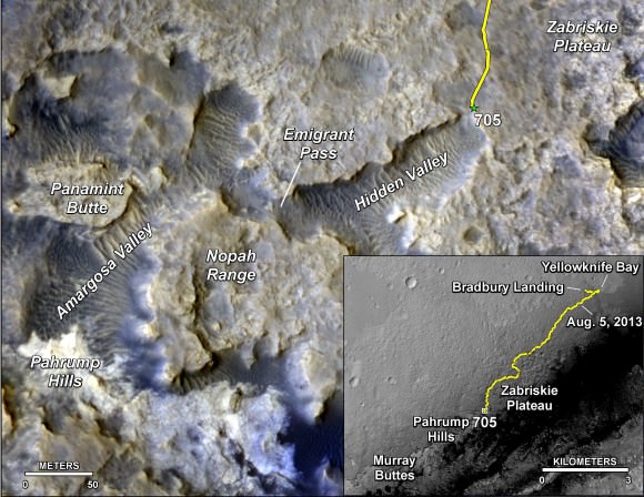
The main map here shows the assortment of landforms near the location of NASA's Curiosity Mars rover as the rover's second anniversary of landing on Mars nears. The gold traverse line entering from upper right ends at Curiosity's position as of Sol 705 on Mars (July 31, 2014). The inset map shows the mission's entire traverse from the landing on Aug. 5, 2012, PDT (Aug. 6, EDT) to Sol 705, and the remaining distance to long-term science destinations near Murray Buttes, at the base of Mount Sharp. The label "Aug. 5, 2013" indicates where Curiosity was one year after landing.    Credit: NASA/JPL-Caltech/Univ. of Arizona
The main map here shows the assortment of landforms near the location of NASA’s Curiosity Mars rover as the rover’s second anniversary of landing on Mars nears. The gold traverse line entering from upper right ends at Curiosity’s position as of Sol 705 on Mars (July 31, 2014). The inset map shows the mission’s entire traverse from the landing on Aug. 5, 2012, PDT (Aug. 6, EDT) to Sol 705, and the remaining distance to long-term science destinations near Murray Buttes, at the base of Mount Sharp. The label “Aug. 5, 2013” indicates where Curiosity was one year after landing. Credit: NASA/JPL-Caltech/Univ. of Arizona

Curiosity still has about another 2 miles (3 kilometers) to go to reach the entry way at a gap in the treacherous sand dunes at the foothills of Mount Sharp sometime later this year.

Mount Sharp is a layered mountain that dominates most of Gale Crater and towers 3.4 miles (5.5 kilometers) into the Martian sky and is taller than Mount Rainier.

“Getting to Mount Sharp is the next big step for Curiosity and we expect that in the Fall of this year,” Dr. Jim Green, NASA’s Director of Planetary Sciences at NASA Headquarters, Washington, DC, told me in an interview making the 2nd anniversary on Aug. 6.

“Drilling on the crater floor will provide needed geologic context before Curiosity climbs the mountain.”

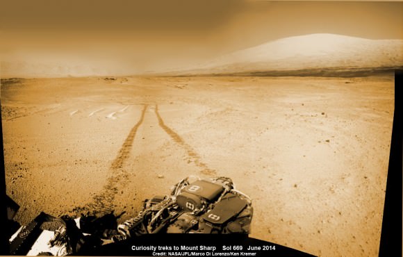
1 Martian Year on Mars!  Curiosity treks to Mount Sharp in this photo mosaic view captured on Sol 669, June 24, 2014.    Navcam camera raw images stitched and colorized.   Credit: NASA/JPL-Caltech/Marco Di Lorenzo/Ken Kremer – kenkremer.com
1 Martian Year on Mars! Curiosity treks to Mount Sharp in this photo mosaic view captured on Sol 669, June 24, 2014. Navcam camera raw images stitched and colorized. Credit: NASA/JPL-Caltech/Marco Di Lorenzo/Ken Kremer – kenkremer.com

Read an Italian language version of this story by my imaging partner Marco Di Lorenzo – here

Stay tuned here for Ken’s continuing Rosetta, Curiosity, Opportunity, Orion, SpaceX, Boeing, Orbital Sciences, Dream Chaser, commercial space, MAVEN, MOM, Mars and more planetary and human spaceflight news.

Ken Kremer

Galaxy May Host ‘Death Spiral’ Of Two Black Holes Becoming One

Artist's conception of two black holes gravitationally bound to each other. Credit: NASA

Two black holes in the middle of a galaxy are gravitationally bound to each other and may be starting to merge, according to a new study.

Astronomers came to that conclusion after studying puzzling behavior in what is known as WISE J233237.05-505643.5, a discovery that came from NASA’s Wide-field Infrared Survey Explorer (WISE). Follow-up studies came from the Australian Telescope Compact Array and the Gemini South telescope in Chile.

“We think the jet of one black hole is being wiggled by the other, like a dance with ribbons,” stated research leader Chao-Wei Tsai of NASA’s Jet Propulsion Laboratory. “If so, it is likely the two black holes are fairly close and gravitationally entwined.”

“The dance of these black hole duos starts out slowly, with the objects circling each other at a distance of about a few thousand light-years,’ NASA added in a press release. “So far, only a few handfuls of supermassive black holes have been conclusively identified in this early phase of merging. As the black holes continue to spiral in toward each other, they get closer, separated by just a few light-years. ”

You can read more details of the find at a press release here, or at this Arxiv paper.

NASA Celebrates Return To Work, But Shutdown’s Shadow Could Linger

A message on the NASA 360 Twitter feed the day employees returned to work after a 16-day government shutdown in October 2013.

After 16 days off the job, most employees at NASA returned to work today (Oct. 17). The good news came after a late-night deal by U.S. politicians to reopen government activities until Jan. 15 and raise the debt limit — originally expected to expire today — until Feb. 7. Democrats and Republicans were battling over the implementation of a new health care law; more details on how the deal was reached are available in this New York Times article.

During the shutdown, only mission-essential functions at NASA were completed except at areas such as the Jet Propulsion Laboratory, which are run by contractors. Twitter, Facebook and social media updates went silent. Missions were run on a needs-only basis, and for a while it looked as though the upcoming MAVEN mission to Mars might be delayed (although it got an exception due to its role as a communications relay for NASA’s rovers.)

So you can imagine the happiness on social media when NASA employees returned to work.

nasa_langley

Given the length of the shutdown,  not all work can just start immediately. Experiments have been left unattended for more than two weeks. Equipment needs to be powered back on. Cancelled meetings and travel arrangements need to, as it is possible, be rebooked.

At NASA’s Marshall Space Flight Center, spokesperson Don Amatore asked employees to be mindful of safety precautions, according to All Alabama. He also stated that “liberal leave” is in effect for employees today and on Friday, meaning that employees are able to take time off without requesting it beforehand — as long as their supervisors know.

Several Twitter reports from NASA contractors on Thursday also indicated that they were unsure if they would be coming back to work on that day, or at some point in the near future. The agency, however, was reportedly sending automated telephone updates to employees and contractors advising them to check with their supervisors for information.

The Stratospheric Observatory for Infrared Astronomy, or SOFIA, 747SP basks in the light of a full moon shining over California’s Mojave Desert. NASA photographer Tom Tschida shot this telephoto image on October 22, 2010 NASA Photo / Tom Tschida
The Stratospheric Observatory for Infrared Astronomy, or SOFIA, 747SP basks in the light of a full moon shining over California’s Mojave Desert. Photo / Tom Tschida

The long-term effects of the shutdown are still coming to light. Certain NASA researchers who planned Antarctic work this year may lose their entire field season. Also, some researchers using NASA or government telescopes missed their “window” of telescope time. “SOFIA remains grounded as a testament to stupidity. Europa keeps her secrets,” wrote Mike Brown,  a professor of planetary astronomy at the California Institute of Technology, on Twitter Oct. 13 about NASA’s Stratospheric Observatory for Infrared Astronomy.

Additionally, the S&P ratings agency noted that the U.S. economy lost $24 billion due to the shutdown, which is more than the initial $17.7 billion request for NASA’s budget in fiscal 2014. Given the agency is in the midst of budget negotiations and is worried about the viability of the commercial crew program, among other items, any long-term economic damage could hurt NASA for a while.

NASA and other government agencies also have only three months of relative stability until the government reaches another funding deadline. What do you think will happen next? Let us know in the comments.

NASA’s Juno Spacecraft Returns 1st Flyby images of Earth while Sailing On to Jupiter

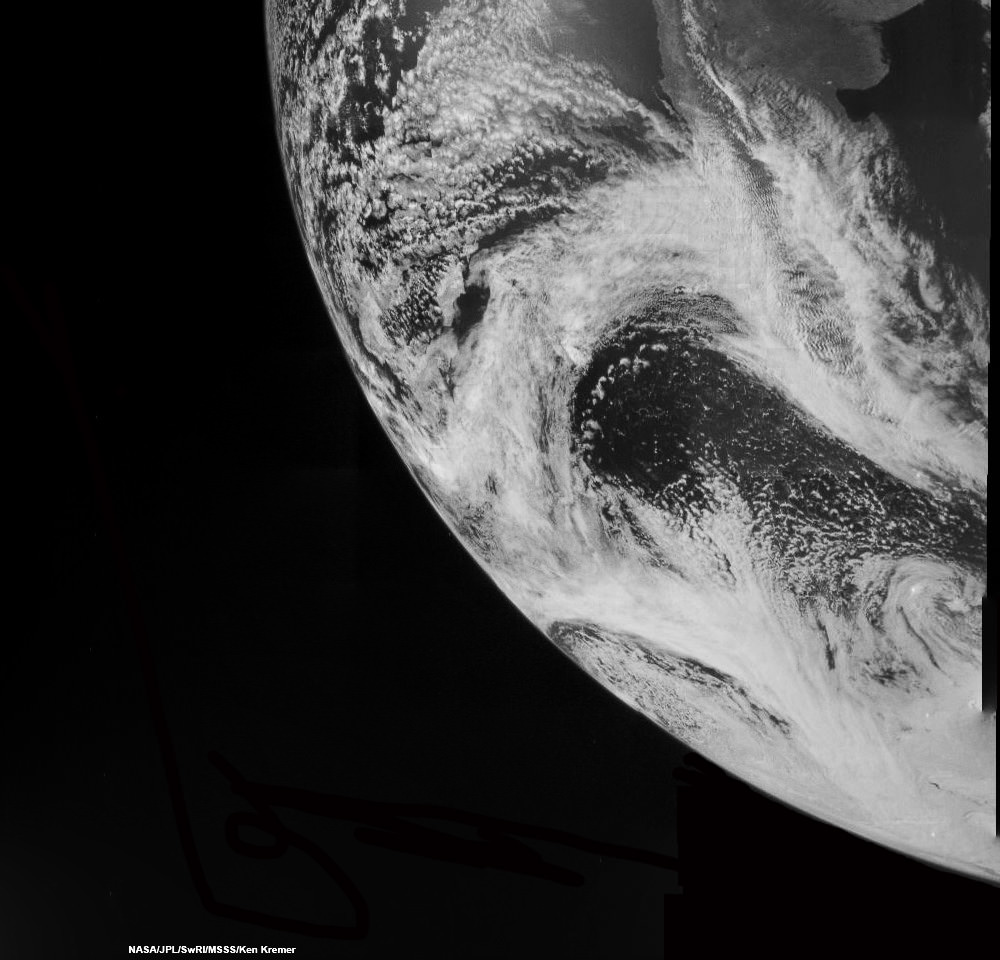
Juno swoops over Argentina This reconstructed day side image of Earth is one of the 1st snapshots transmitted back home by NASA’s Jupiter-bound Juno spacecraft during its speed boosting flyby on Oct. 9, 2013. It was taken by the probes Junocam imager and methane filter at 12:06:30 PDT and an exposure time of 3.2 milliseconds. Juno was flying over South America and the southern Atlantic Ocean. The coastline of Argentina is visible at top right. Credit: NASA/JPL/SwRI/MSSS/Ken Kremer

Following the speed boosting slingshot of Earth on Wednesday, Oct. 9, that sent NASA’s Juno orbiter hurtling towards Jupiter, the probe has successfully transmitted back data and the very first flyby images despite unexpectedly going into ‘safe mode’ during the critical maneuver.

Juno is transmitting telemetry today,” spokesman Guy Webster, of NASA’s Jet Propulsion Lab (JPL), told me in a phone interview late today (Oct. 10), as Juno continues sailing on its 2.8 Billion kilometer (1.7 Billion mile) outbound trek to the Jovian system.

The new images of Earth captured by the Junocam imager serves as tangible proof that Juno is communicating.

“Juno is still in safe mode today (Oct. 10),” Webster told Universe Today.

“Teams at mission control at JPL and Lockheed Martin are actively working to bring Juno out of safe mode. And that could still require a few days,” Webster explained.

Lockheed Martin is the prime contractor for Juno.

The initial raw images of Earth snapped by the craft’s Junocam imager were received by ground stations late today.

See above a day light image mosaic which I reconstructed and realigned based on the original raw image (see below) taken with the camera’s methane filter on Oct. 9 at 12:06:30 PDT (3:06:30 PM EST). Juno was to be flying over South America and the southern Atlantic Ocean.

This day side raw image of Earth is one of the 1st snapshots transmitted back home today by NASA’s Juno spacecraft during its speed boosting flyby on Oct. 9, 2013. It was taken by the probes Junocam imager and methane filter at 12:06:30 PDT and an exposure time of 3.2 ms. Credit: NASA/JPL/SwRI/MSSS
This day side raw image of Earth is one of the 1st snapshots transmitted back home today by NASA’s Juno spacecraft during its speed boosting flyby on Oct. 9, 2013. It was taken by the probes Junocam imager and methane filter at 12:06:30 PDT and an exposure time of 3.2 milliseconds. Juno was due to be flying over South America and the southern Atlantic Ocean. Credit: NASA/JPL/SwRI/MSSS

Juno performed a crucial swingby of Earth on Wednesday that accelerated the probe by 16330 MPH to enable it to arrive in orbit around Jupiter on July 4, 2016.

However the gravity assist maneuver did not go entirely as planned.

Shortly after Wednesday’s flyby, Juno Project manager Rick Nybakken, of JPL, told me in a phone interview that Juno had entered safe mode but that the probe was “power positive and we have full command ability.”

“After Juno passed the period of Earth flyby closest approach at 12:21 PM PST [3:21 PM EDT] and we established communications 25 minutes later, we were in safe mode,” Nybakken explained.

The safe mode was triggered while Juno was in an eclipse mode, the only eclipse it will experience during its entire mission.

The Earth flyby did accomplish its objective by placing the $1.1 Billion Juno spacecraft exactly on course for Jupiter as intended.

“We are on our way to Jupiter as planned!”

“None of this affected our trajectory or the gravity assist maneuver – which is what the Earth flyby is,” Nybakken stated.

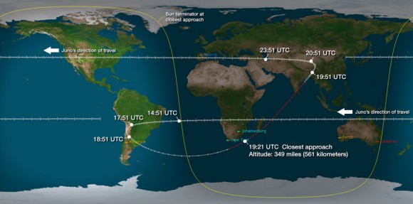
Juno’s closest approach was over South Africa at about 561 kilometers (349 miles).

Juno’s flight track above Earth during Oct. 9, 2013 flyby. Credit: NASA/JPL

During the flyby, the science team also planned to observe Earth using most of Juno’s nine science instruments since the slingshot also serves as a key test of the spacecraft systems and the flight operations teams.

Juno also was to capture an unprecedented new movie of the Earth/Moon system.

Many more images were snapped and should be transmitted in coming days that eventually will show a beautiful view of the Earth and Moon from space.

“During the earth flyby we have most of our instruments on and will obtain a unique movie of the Earth Moon system on our approach, Juno principal investigator Scott Bolton told me. Bolton is from the Southwest Research Institute (SwRI), San Antonio, Texas.

“We will also calibrate instuments and measure earth’s magnetosphere, obtain closeup images of the Earth and the Moon in UV [ultraviolet] and IR [infrared],” Bolton explained to Universe Today.

Juno is approaching the Earth from deep space, from the sunlit side.

“Juno will take never-before-seen images of the Earth-moon system, giving us a chance to see what we look like from Mars or Jupiter’” says Bolton.

Here is a description of Junocam from the developer – Malin Space Science Systems

“Like previous MSSS cameras (e.g., Mars Reconnaissance Orbiter’s Mars Color Imager) Junocam is a “pushframe” imager. The detector has multiple filter strips, each with a different bandpass, bonded directly to its photoactive surface. Each strip extends the entire width of the detector, but only a fraction of its height; Junocam’s filter strips are 1600 pixels wide and about 155 rows high. The filter strips are scanned across the target by spacecraft rotation. At the nominal spin rate of 2 RPM, frames are acquired about every 400 milliseconds. Junocam has four filters: three visible (red/green/blue) and a narrowband “methane” filter centered at about 890 nm.”

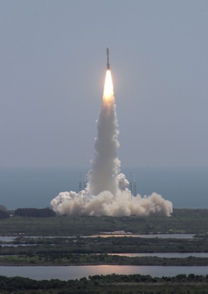
Juno soars skyward to Jupiter on Aug. 5, 2011 from launch pad 41 at Cape Canaveral Air Force Station at 12:25 p.m. EDT. View from the VAB roof. Credit: Ken Kremer/kenkremer.com
Juno launched atop an Atlas V rocket two years ago from Cape Canaveral Air Force Station, FL, on Aug. 5, 2011 on a journey to discover the genesis of Jupiter hidden deep inside the planet’s interior.

During a one year long science mission – entailing 33 orbits lasting 11 days each – the probe will plunge to within about 3000 miles of the turbulent cloud tops and collect unprecedented new data that will unveil the hidden inner secrets of Jupiter’s origin and evolution.

NBC News has also featured this Juno story – here

Read more about Juno’s flyby in my articles – here and here

Stay tuned here for continuing Juno, LADEE, MAVEN and more up-to-date NASA news.

Ken Kremer

Planck’s Cosmic Map Reveals Universe Older, Expanding More Slowly

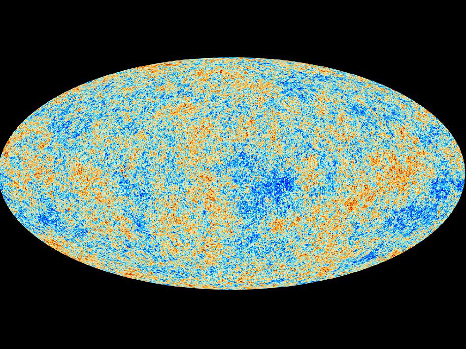
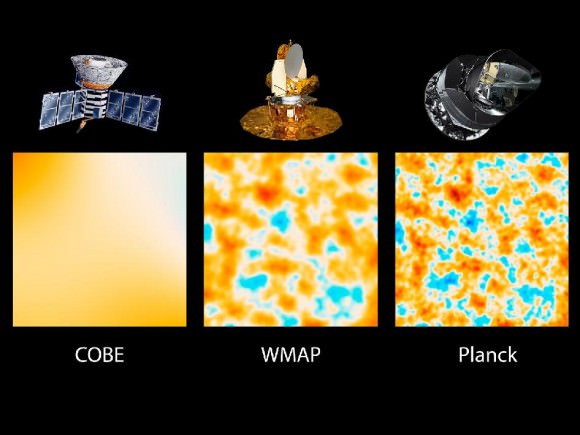
Like archaeologists sifting through the dust of ancient civilizations, scientists with the ESA Planck mission today showed a map of the oldest light in the Universe. The first cosmology results of the mission suggest our Universe is slightly older and expanding more slowly than previously thought.

Planck’s new estimate for the age of the Universe is 13.82 billion years.

The map also appears to show more matter and dark matter and less dark energy, a hypothetical force that is causing an expansion of the Universe.

“We are measuring the oldest light in the Universe, the cosmic microwave background,” says Paul Hertz, director of astrophysics with NASA. “It is the most sensitive and detailed map ever. It’s like going from standard television to a new high definition screen. The new details have become crystal clear.”

Overall, the cosmic background radiation, the afterglow of the Universe’s birth, is smooth and uniform. The map, however, provides a glimpse of the tiny temperature fluctuations that were imprinted on the sky when the Universe was just 370,000 years old. Scientists believe the map reveals a fossil, an imprint, of the state of the Universe just 10 nano-nano-nano-nano seconds after the Big Bang; just a tiny fraction of the time it took to read that sentence. The splotches in the Planck map represent the seeds from which the stars and galaxies formed.

The colors in the map represent different temperatures; red for warmer, blue for cooler. The temperature differences being only 1/100 millionth of a degree. “The contrast on the map has been turned way up,” says Charles Lawrence, the US project scientist for Planck at NASA’s Jet Propulsion Laboratory in Pasadena, Calif.

Planck, launched in 2009 from the Guiana Space Center in French Guiana, is a European Space Agency mission with significant contribution from NASA. The two-ton spacecraft gathers the ancient glow of the Universe’s beginning from a vantage more than 1 million miles from Earth.

735692main_pia16874-43_946-710
This graphic shows the evolution of satellites designed to measure the light left over from the Big Bang that created our Universe about 13.8 billion years ago. Called the cosmic background radiation, the light reveals information about the early Universe. The three panels show the same 10-square-degree patch of sky as seen by NASA’s Cosmic Background Explorer, or COBE, NASA’s Wilkinson Microwave Anisotropy Probe, or WMAP, and Planck. Planck has a resolution about 2.5 times greater than WMAP. Credit: NASA/JPL-Caltech/ESA

This is not the first map produced by Planck. In 2010, Planck produced an all-sky radiation map. Scientists, using supercomputers, have removed not only the bright emissions from foreground sources, like the Milky Way, but also stray light from the satellite itself.

As the light travels, matter scattered throughout the Universe with its associated gravity subtly bends and absorbs the light, “making it wiggle to and fro,” said Martin White, a Planck project scientist with the University of California, Berkeley and the Lawrence Berkeley National Laboratory.

“The Planck map shows the impact of all matter back to the edge of the Universe,” says White. “It’s not just a pretty picture. Our theories on how matter forms and how the Universe formed match spectacularly to this new data.”

“This is a treasury of scientific data,” said Krzysztof Gorski, a member of the Planck team with JPL. “We are very excited with the results. We find an early Universe that is considerably less rigged and more random than other, more complex models. We think they’ll be facing a dead-end.”

An artists animation depicting the “life” of a photon, or a particle light, as it travels across space and time from the beginning of the Universe to the detectors of the Planck telescope. Credit: NASA

Planck scientists believe the new data should help scientists refine many of the theories proposed by cosmologists that the Universe underwent a sudden and rapid inflation.

Curiosity Celebrates 1st Martian Christmas at Yellowknife Bay

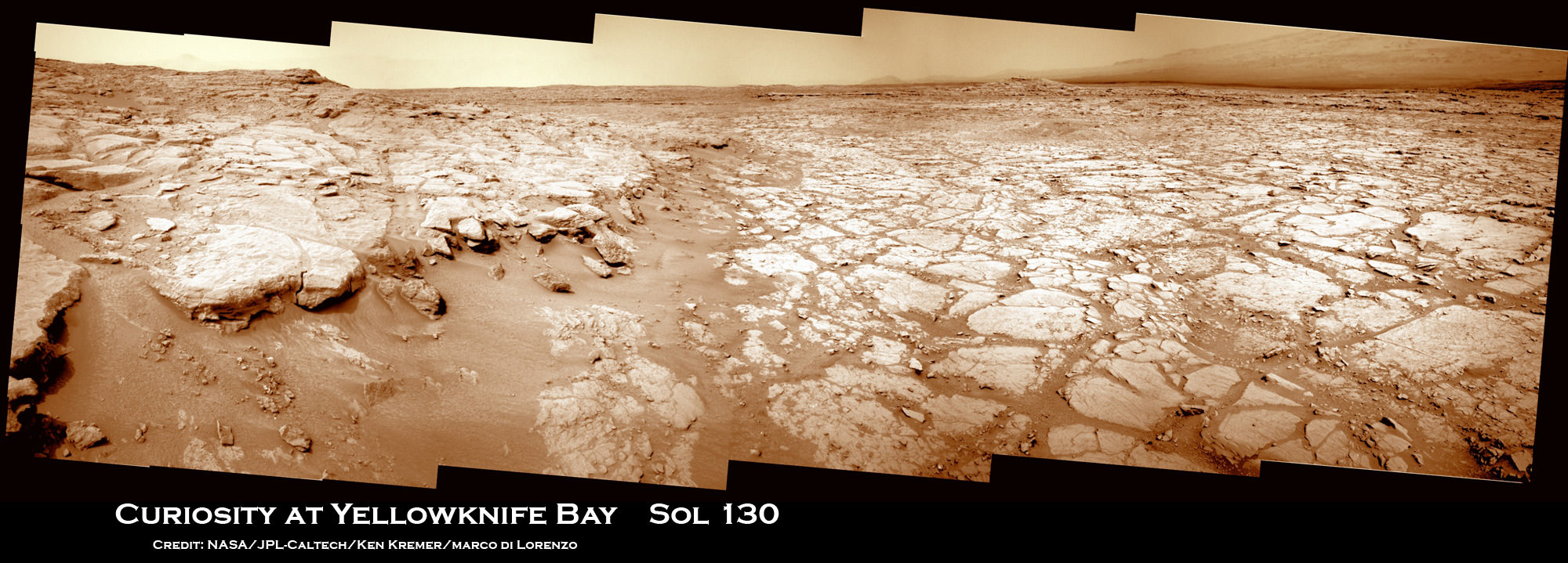
Image Caption: Curiosity Scans ‘Yellowknife Bay’ on Sol 130. NASA’s Curiosity rover celebrated her 1st Christmas on the Red Planet at ‘Yellowknife Bay’ and is searching for her 1st rock target to drill into for a sample to analyze. She snapped this panoramic view on Dec. 17 which was stitched together from navigation camera (Navcam) images. Credit: NASA/JPL-Caltech/Ken Kremer/Marco Di Lorenzo

Today (Dec. 25) Curiosity celebrates her 1st Christmas on Mars at a spot called ‘Yellowknife Bay’. It’s Sol 138 and nearly 5 months since the pulse pounding landing on Aug. 6, 2012 inside Gale Crater. The robot is in excellent health.

Meanwhile her older sister Opportunity will soon celebrate an unfathomable 9 Earth years on Mars in a few short weeks on Jan. 24, 2013 – on the other side of the planet.

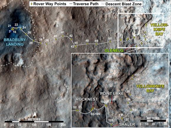
NASA’s Curiosity rover reached the shallow depression named ‘Yellowknife Bay’ on Sol 130 (Dec. 17, 2012) after descending about 2 feet (0.5 m) down a gentle slope inside a geologic feature dubbed ‘Glenelg’. See our panoramic mosaics from Yellowknife Bay – above and below for a context view.

The science team is searching for an interesting rock for the inaugural use of the high powered hammering drill.

According to a new report in SpaceRef, the drilling has been delayed due to concerns that frictional heating may potentially cause liquification of the rock to a gooey “Martian Honey” that could potentially clog and seriously damage the sample handling sieves and mechanisms. So the team is carefully re-evaluating the type of rock target and the drilling operation procedures before committing to the initial usage of the percussive drill located on the turret at the terminus of the robotic arm.

The team chose to drive to ‘Yellowknife Bay’ because it features a different type of geologic terrain compared to what Curiosity has driven on previously. The ‘Glenelg’ area lies at the junction of three different types of geologic terrain and is Curiosity’s first extended science destination.

Curiosity arrived at the lip of Yellowknife Bay on Sol 124 and entered the basin on Sol 125 (Dec. 12) and snapped a scouting panoramic view peering into the inviting locale. The rover is also using the APXS X-ray mineral spectrometer, ChemCam laser and MAHLI hand lens imager to gather initial science characterization data.

Curiosity peaks around Yellowknife Bay on Sol 125, Dec 12, 2012. The rover continued driving inside the basin in search of 1st rock drill target. Credit: NASA/JPL-Caltech/Ken Kremer/Marco Di Lorenzo

So far the rover has traversed a total driving distance of some 0.43 mile (700 meters).

Most of the science and engineering team is getting a much needed break to spend time with their families after uploading 11 Sols worth of activities ahead of time to keep the robot humming during the Christmas holiday season. A skeleton crew at JPL is keeping watch to deal with any contingencies.

One of the top priorities is acquiring a high resolution 360 degree Mastcam color panorama. This will be invaluable for selection of the very 1st rock target to drill into and acquire a sample from the interior – a feat never before attempted on Mars.

“We decided to drive to a place with a good view of the outcrops surrounding Yellowknife Bay to allow good imaging of these outcrops before the holiday break,” says rover science team member Ken Herkenhoff. “As the images are returned during the break, we can use them to help decide where to perform the first drilling operation.”

The team expects to choose a drill target sometime in January 2013 after a careful selection process.

The 7 foot (2 m) long robotic arm will deliver that initial, pulverized rock sample to inlet ports on the rover deck for analysis by the high powered duo of miniaturized chemistry labs named Chemin & SAM.

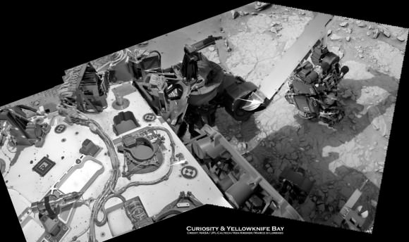
Image Caption: Curiosity deploys robotic arm on Sol 129 and examines rock with APXS and MAHLI science instruments to characterize rock and soil composition. This composite mosaic was stitched from Navcam images from Sol 129 (Dec. 16) and earlier sols- and shows the location of the Chemin sample inlet port on the rover deck. Credit: NASA/JPL-Caltech/Ken Kremer/Marco Di Lorenzo

Curiosity will spend at least another month or more investigating Glenelg before setting off on the nearly year long trek to her main destination – the sedimentary layers of the lower reaches of the 3 mile (5 km) high mountain named Mount Sharp.

Image caption: Scanning Mount Sharp from Yellowknife Bay on Sol 136. This photo mosaic assembled from Mastcam 100 camera images was snapped by Curiosity on Sol 136 (Dec. 23) – from her current location. It shows a portion of the layered mound called Mount Sharp, her main destination. Acquiring a 360 high resolution color panorama from Yellowknife Bay is a high priority task for the rover during the Christmas holiday season. Credit: NASA/JPL-Caltech/Marco Di Lorenzo/Ken Kremer

As the Martian crow flies, the breathtaking environs of Mount Sharp are some 6 miles (10 km) away.

The mission goal is to search for habitats and determine if Mars ever could have supported microbial life in the past or present during the 2 year primary mission phase.

Ken Kremer

Image Caption: Curiosity Traverse Map, Sol 130. This map traces where Curiosity drove between landing at a site named “Bradbury Landing,” and the position reached during Sol 130 (Dec. 17, 2012) at a spot named “Yellowknife Bay” which is inside an area called “Glenelg”. The inset shows the most recent legs of the traverse in greater detail. Credit: NASA/JPL-Caltech/Univ. of Arizona