Flags Still Standing at Several Apollo Landing Sites on the Moon

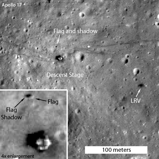
Caption: LROC image showing the illuminated side of the still standing American flag to be captured at the Apollo 17 landing site. Credit: NASA/GSFC/Arizona State University.

Mark Robinson, Principal Investigator of the Lunar Reconnaisance Orbiter Camera (LROC) says the most often-asked questions he gets about the images LRO has taken of the Moon are about pictures of the Apollo landing sites and what is visible. Especially, Robinson said, people want to know if the flags are still standing.

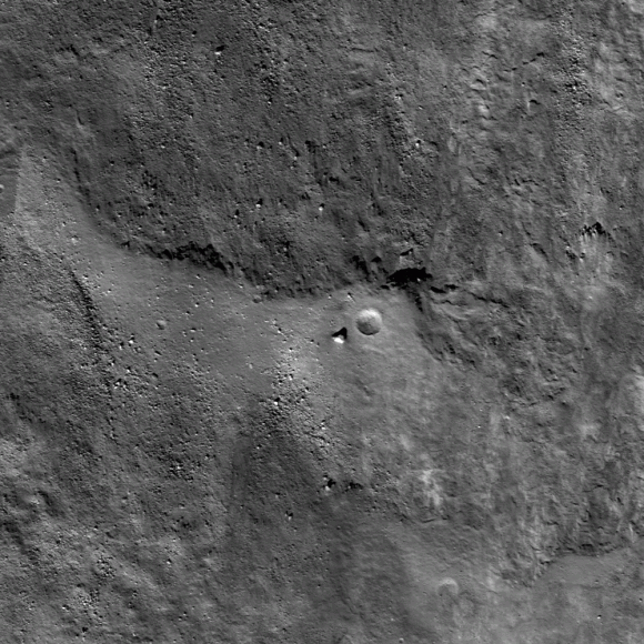
Previously, Robinson has said that while the flag poles are likely still standing, he didn’t think the flags themselves survived the harsh radiation of the lunar surface environment. But new images and video show that at some of the landing sites – Apollo 12, Apollo 16, and Apollo 17 – the flags must still be intact, because they are creating shadows on the surface.

“Personally I was a bit surprised that the flags survived the harsh ultraviolet light and temperatures of the lunar surface, but they did,” Robinson wrote on the LROC website. “What they look like is another question (badly faded?).”
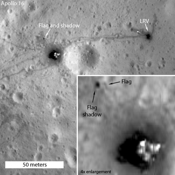

Caption: The flag was captured in this image of the Apollo 16 site with the spacecraft slewed 15° towards the Sun; the shadowed side of the flag is seen by LROC. Credit: NASA/GSFC/Arizona State University.

James Fincannon, a NASA engineer from Glenn Research Center, combined LROC images of each Apollo site taken at roughly the same orientation but with different Sun angles to show the travel of shadows.

“Combined with knowledge of the Apollo site maps which show where the flag was erected relative to the Lander, long shadows cast by the flags at the three sites show that the these flags are still “flying”, held aloft by the poles,” Fincannon wrote.

And so, from the LROC images it is now certain that the American flags are still standing and casting shadows at all of the sites, except Apollo 11. Astronaut Buzz Aldrin reported that the flag was blown over by the exhaust from the ascent engine during liftoff of Apollo 11, and Robinson said that from the images of the Apollo 11 landing site, it looks like he was correct.
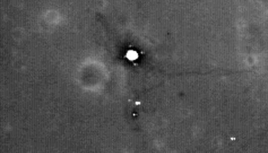

Caption: Enlargement of area surrounding Apollo 11 landing site. Credit: NASA/GSFC/Arizona State University

Robinson added that the most convincing way to see that the flags are still there, is to view a time series of LROC images taken at different times of day, and watch the shadow circle the flag (see movie below; the flag is just above the LM descent stage).

Read Fincannon’s story of his research on the flags.

Source: LROC website.

Barnstorming the Moon’s Giordano Bruno Crater

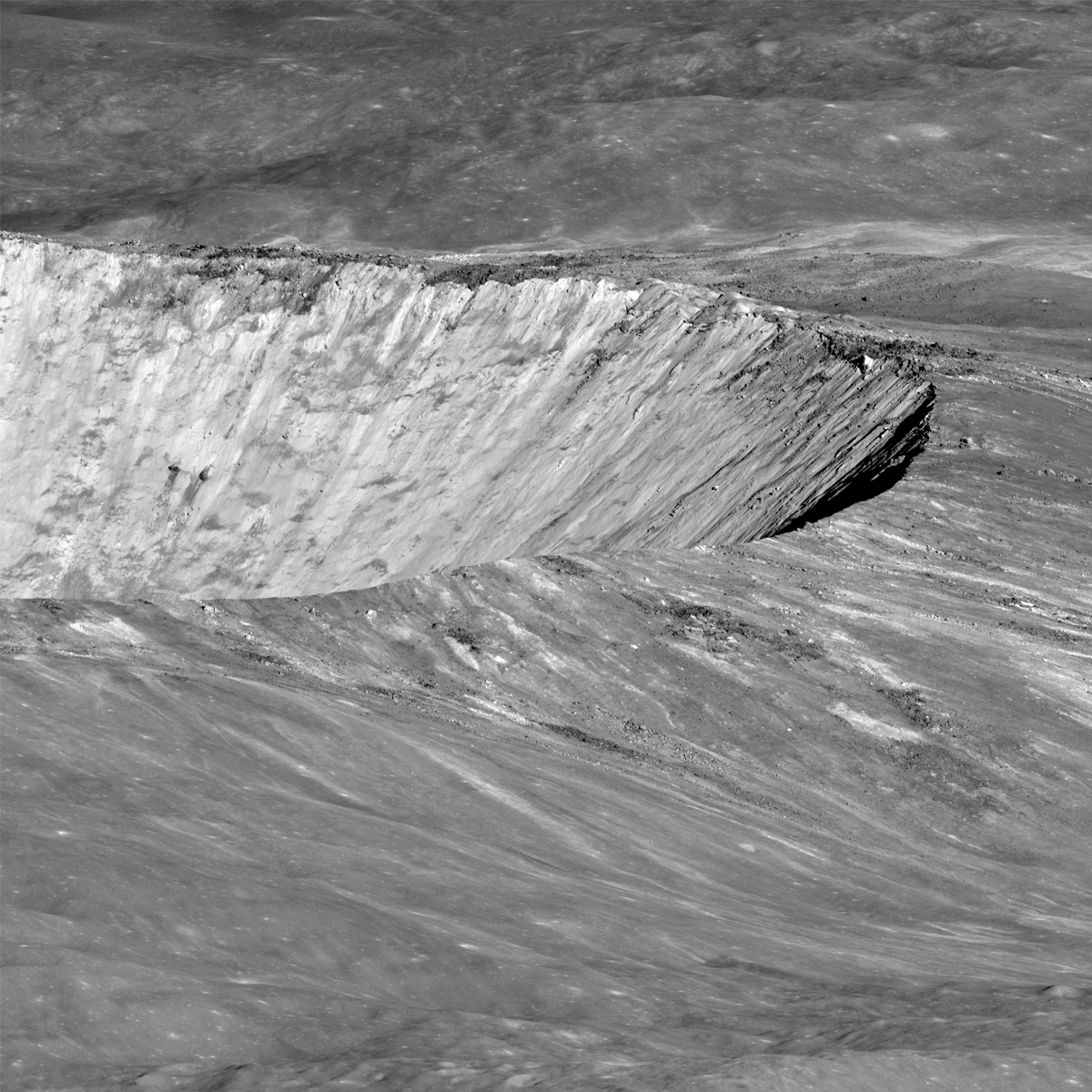
Caption: Southern rim of Giordano Bruno crater seen obliquely by LROC. Credit: NASA/GSFC/Arizona State University

At the 2012 Lunar Science Forum going on this week at the NASA Lunar Science Institute, scientist Mark Robinson presented some new stunning images from the Lunar Reconnaissance Orbiter’s cameras (LROC), including this oblique view Giordano Bruno crater, and a wonderful video (below) that allows viewers to “barnstorm” over the crater to witness the stark beauty of this impact basin.

“I could spend weeks and months looking at the preserved materials in the crater,” Robinson said, adding that views like this are helping scientists to understand the impact process. “Until astronauts visit Giordano Bruno, this gives a view about as close as you can get to standing on the surface to the west of the crater.”

Robinson is the Principal Investigator for LROC, and in his talk today said all systems on LROC are working nominally. “That’s NASA-speak for everything is fantastic,” he joked.

With the wide angle camera, LROC has mapped the entire Moon nearly 33 times. “Every map has a different photometric geometry, so this is not a redundant dataset,” Robinson said, adding that the different lighting provides different ways to study the Moon. “And to be able to do follow-up observations, I can’t tell you how great it is.”

Just about every month, the science team is able to take new mosaics of both the north and south pole, and they’ve also found 160 pits – lunar caves – so far. These caves with “skylights” are intriguing because they would offer potential protective habitats for future lunar explorers.

Now in its extended mission, LRO is still going strong, and has provided incredible details of the lunar surface. LRO project scientist Richard Vondrak said since the start of the mission, LRO has uploaded 325 terabytes of data into the Planetary Data System, the digital storehouse for NASA science mission, through June 2012.


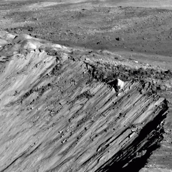
Caption: Close-up detail of the rim of Giordano Crater. Credit: NASA/GSFC/Arizona State University

“Thanks to LRO, the Moon’s topography is now better understood than the Earth, since two-thirds of Earth is covered by water,” Vondrak said.
But both scientists agrees LRO is just getting started.

“The Moon is one of the most engaging bodies in the Solar System and we’ve still got a lot of work to do,” Robinson said

Robinson suggests scrolling through all of the details of this beautiful impact crater by looking at the full-resolution version of Giordano Crater — “not to be missed!” he said. Also, the full resolution version of the video can be downloaded here.

Sources: NLSI Lunar Forum, LROC website

Rivers of Rock

The Moon may not have ever had liquid water on its surface — despite the use of the term mare, Latin for “sea” and moniker for the large regions of darker material visible from Earth — but liquid did indeed flow on the Moon in ages past… liquid rock, briefly set loose by the impacts that formed its ubiquitous craters.

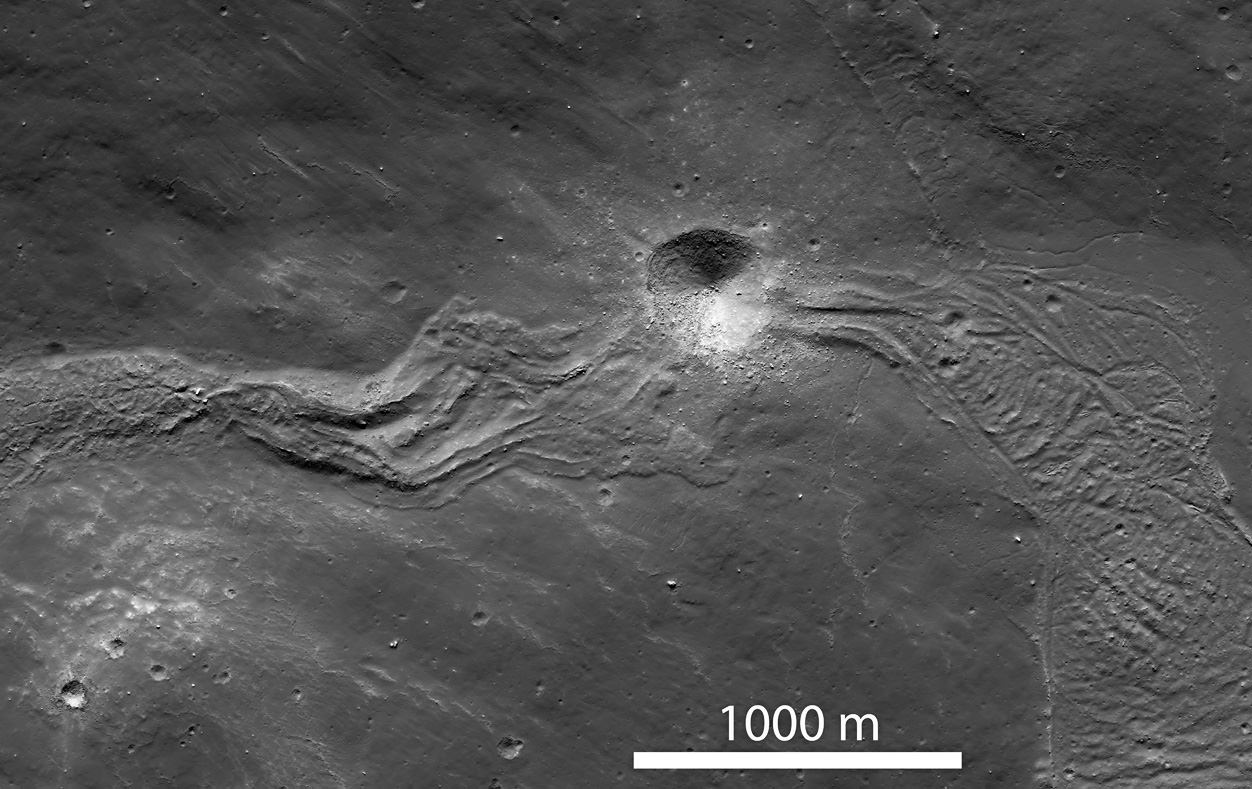
When large meteorites impacted the Moon, crust at the site would melt and get flung outwards, flowing downhill as rivers of rock and creating streams and pools of melted material before cooling and solidifying. There the rivers would remain, a permanently-hardened testament to the event that made them.

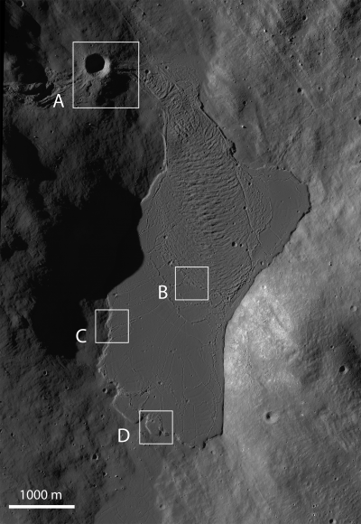
The image above, part of a NAC scan acquired by NASA’s Lunar Reconnaissance Orbiter on March 9, shows a solidified melt flow dating back to the creation of Tycho crater approximately 108 million years ago –which may sound like a long time but it’s actually very recent for large-scale lunar features.

The flow is interrupted by a younger, 400-meter-wide crater that impacted the lunar surface along its length. Since it punches through the melt flow as well as the local surface, it would be a great place for future astronaut geologists to explore!

Taken under slightly different lighting conditions, the image below shows a large melt pond that the flow above terminates in. The pond is about 4500 meters long by 2100 meters across (2.8 x 1.3 miles).

Such images wouldn’t be possible without the awesome Lunar Reconnaissance Orbiter. Launched on June 18, 2009, LRO explores the lunar surface from an altitude of only 50 km (31 miles). Read more on the LRO site here.

Image credits: NASA/GSFC/Arizona State University

Loads of Ice Waiting for Explorers at the Moon’s Shackleton Crater

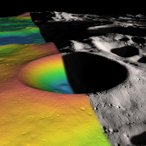
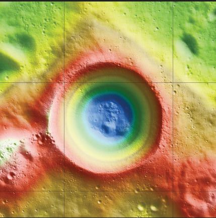
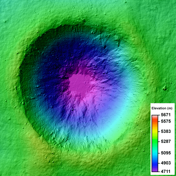
Shackleton crater on the Moon’s south pole has been somewhat of an enigma, as its permanently shadowed interior has made it difficult to detect what is inside. But with new observations using the laser altimeter on the Lunar Reconnaissance Orbiter (LRO) spacecraft, a team of researchers has essentially illuminated the crater’s interior with laser light, measuring its albedo, or natural reflectance. The scientists found that the crater’s floor is quite bright, an observation consistent with the presence of ice. In fact, ice may make up 22 percent of the material on the crater floor, with possibly more ice embedded within the crater walls.

“We decided we would study the living daylights out of this crater,” said Maria Zuber from the Massachuesetts Institute of Technology, who lead a team to study Shackleton Crater. “From the incredible density of observations we were able to make an extremely detailed topographic map.”

For laser altimeter observations, elevation maps can be created by measuring the time it takes for laser light to bounce down to the Moon’s surface and back to the instrument. The longer it takes, the lower the terrain’s elevation. Using these measurements, the group mapped the crater’s floor and the slope of its walls.

The team used over 5 million measurements to create their detailed map.


While the crater’s floor was relatively bright, Zuber and her colleagues observed that its walls were even brighter. The finding was at first puzzling. Scientists had thought that if ice were anywhere in a crater, it would be on the floor, where no direct sunlight penetrates. The upper walls of Shackleton crater are occasionally illuminated, which could evaporate any ice that accumulates. A theory offered by the team to explain the puzzle is that “moonquakes”– seismic shaking brought on by meteorite impacts or gravitational tides from Earth — may have caused Shackleton’s walls to slough off older, darker soil, revealing newer, brighter soil underneath. Zuber’s team’s ultra-high-resolution map provides strong evidence for ice on both the crater’s floor and walls.

“There may be multiple explanations for the observed brightness throughout the crater,” said Zuber. “For example, newer material may be exposed along its walls, while ice may be mixed in with its floor.”

The crater, named after the Antarctic explorer Ernest Shackleton, is nearly 20 km (more than 12 miles) wide and over 3 km (2 miles) deep — about as deep as Earth’s oceans. Zuber described the crater’s interior as “extremely rugged … It would not be easy to crawl around in there.”

She added that the new topographic map will help researchers understand crater formation and study other uncharted areas of the moon.

“I will never get over the thrill when I see a new terrain for the first time,” Zuber said. “It’s that sort of motivation that causes people to explore to begin with. Of course, we’re not risking our lives like the early explorers did, but there is a great personal investment in all of this for a lot of people.”

Ben Bussey, staff scientist at Johns Hopkins University’s Applied Physics Laboratory, said the new evidence for ice in Shackleton crater may indeed help determine the course for future lunar missions.

“Ice in the polar regions has been sort of an enigmatic thing for some time … I think this is another piece of evidence for the possibility of ice,” Bussey says. “To truly answer the question, we’ll have to send a lunar lander, and these results will help us select where to send a lander.”

And for any humans explorers, a crater like Shackleton at the lunar poles may well be the best location for a base, as the poles contain regions of near-permanent sunlight needed for power, and regions of near-permanent darkness containing ice — both of which would be essential resources for any lunar colony.

The team’s research was published today in the Journal Nature.

Sources: MIT, NASA

Lead image caption: Elevation (left) and shaded relief (right) image of Shackleton, a 21-km-diameter (12.5-mile-diameter) permanently shadowed crater adjacent to the lunar south pole. The structure of the crater’s interior was revealed by a digital elevation model constructed from over 5 million elevation measurements from the Lunar Orbiter Laser Altimeter. Credit: NASA/Zuber, M.T. et al., Nature, 2012

Second image caption: This is an elevation map of Shackleton crater made using LRO Lunar Orbiter Laser Altimeter data. The false colors indicate height, with blue lowest and red/white highest. Credit: NASA/Zuber, M.T. et al., Nature, 2012

In the Shadow of the Moon: A Lunar View of an Eclipse

The LROC turns to capture the Moon's shadow during the May 20 solar eclipse [NASA/GSFC/Arizona State University].

[/caption]

The May 20 annular eclipse may have been an awesome sight for skywatchers across many parts of the Earth, but it was also being viewed by a robotic explorer around the Moon!

During the event NASA’s Lunar Reconnaissance Orbiter turned its camera to look back home, acquiring several images of the Earth with the Moon’s fuzzy shadow cast onto different regions during the course of the eclipse. The image above is a 4-panel zoom into one particular NAC image showing the Moon’s shadow over the Aleutian Islands.

LRO captured a total of four narrow-angle camera (NAC) images during two of its orbits. During one orbit the Moon’s shadow was over the southern part of Japan, and during the next it had moved northeast to cover the island chain of Alaska.

According to the LROC site run by Arizona State University:

The NAC is a line scanner, meaning that it has only one row of 5064 pixels per camera. Instead of snapping a single frame, an image is built up by the motion of the spacecraft in orbit about the Moon (about 1600 meters per second). To obtain an image of the Earth the spacecraft is turned 180° to face the Earth, then the spacecraft is pitched as quickly as possible (one-tenth of a degree per second), so that the image is built up line by line.

This also explains why some of the images are “clipped” on the edges… LRO ran out of time during its lunar orbit. Still, it’s great to be able to show some photos of the eclipse from quite possibly the most distant viewer anywhere!

Read more on the LROC site here.

Animation of four LROC images of the annular eclipse (click to play) NASA/GSFC/Arizona State University

Moon Craters 3-D!

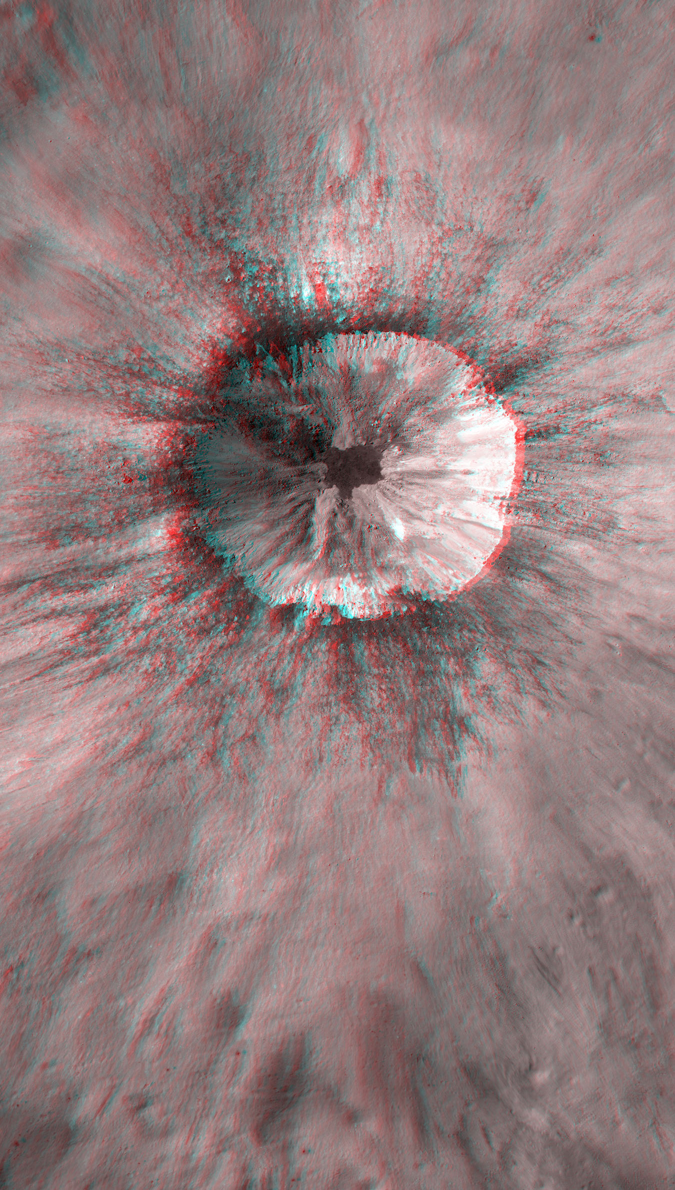
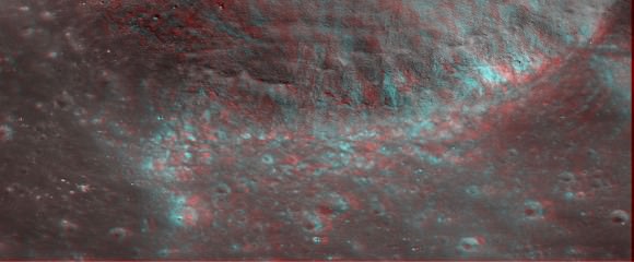
A young unnamed crater on the Moon west of Isaev crater. Credit: NASA/GSFC/Arizona State University; Anaglyph by Nathanial Burton-Bradford.

[/caption]

While many are hoping to see a larger-than-usual view of the Moon this weekend, here’s some great 3-D closeups courtesy of the Lunar Reconnaissance Orbiter and imaging wizard Nathanial Burton Bradford. This great 3-D view (Red/Cyan glasses needed) shows quite an interesting young impact crater on the Moon, (17.682°S, 144.408°E) west of Isaev crater. Click on the image for a larger view, and in 3-D you can dive right in and see all the nooks and crannies – what scientists call complex crater morphology.

Below you can view a Digital Terrain Model, or DTM of this same crater, and find the specifics of how deep the various parts of the crater are and other information critical to scientific investigations of the Moon.

Digital Terrain Model (DTM) of an unnamed crater in the farside highlands. Image is 3.2 km across. Credit: NASA/GSFC/Arizona State University.

Another recent view released by the LRO camera team is of impact melt deposit on another unnamed crater on nearside highlands (38.112°N, 53.052°E; northeast of Mare Tranquillitatis). Again, Nathanial Burton-Bradford provides a 3-D view, and amazingly, the crater walls appear deceptively steep in 3-D as opposed to the regular 2-D view:

3D anaglyph of rim impact melt deposit on Unnamed crater on nearside highlands (38.112°N, 53.052°E; northeast of Mare Tranquillitatis). Credit: NASA/GSFC/Arizona State University; anaglyph by Nathanial Burton-Bradford.

What is impact melt? “So much energy is released when an asteroid or comet slams into the Moon that some of target rock (the Moon) is melted,” wrote Lillian Ostrach on the LRCO website. “For large craters, such as Tycho or Copernicus, the impact event responsible for forming these craters was large enough to generate melt that coated and covered the crater floor, and ejected melt pooled and flowed outside the crater cavity.”

Ostrach says that LROC images show that impact melt is widespread and quite common to lunar impact craters — but as this image shows – take a close look to find channels, flows, and veneers across much of the region.

Here’s LROC’s regular view:

Impact melt started to flow back into the crater cavity before it solidified. Image width is 500 m, from the LROC Narrow Angle Camera. Credit: NASA/GSFC/Arizona State University.

Find out more about these recent LRO images on the LROC website, and see more of Nathanial’s photography handiwork at his DeviantArt page.

Lunar Satellite Reveals Apollo 16 Remains

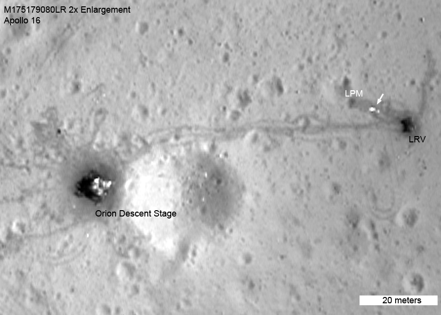
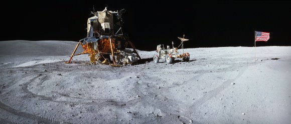
LROC image of the Apollo 16 site showing the Orion LM. (NASA/GSFC/Arizona State University)


NASA’s Lunar Reconnaissance Orbiter (LRO) made a low pass over the Apollo 16 site last fall, capturing images of the leftovers from John Young and Charlie Duke’s 1972 exploration of the Descartes Highlands. The video above takes us on a tour of the Apollo 16 site from lunar orbit, and includes audio from the original communications and some very nice comparative photos and video clips showing the same features from ground level.

The goal of Apollo 16 was to explore for the first time a lunar highlands location, and collect samples of what were initially thought to be volcanic rocks. The rocks were believed to be of a different material than what was collected during previous missions.

As it turned out, the rocks collected by Duke and Young weren’t volcanic in origin at all; they ended up being breccias — cemented-together chunks ejected from ancient cratering events hundreds of miles away.

Apollo 16 also set up various experiment packages to study lunar geology, magnetism and the solar wind. The Lunar Roving Vehicle (LRV) allowed Young and Duke to travel across a much wider area than they would have otherwise been able to on foot. It was the second mission to use an LRV, and the rover — as well as its tracks — are still there today, looking exactly as they did when they were left 40 years ago.

[/caption]

The Apollo 16 ascent stage lifted off from the lunar surface on the evening of April 23, 1972 and docked with the Command Module containing Ken Mattingly. The following day the astronauts began their trip back to Earth, completing the 250,000-mile traverse three days later on April 27.

The Moon would be visited again in December of that same year during Apollo 17, the last mission of the program and the last time that humans would walk on the surface of another world. Now, 40 years later, satellites orbiting the Moon take pictures of what was left behind by these historic events. Perhaps someday soon the sites will be visited from ground level… maybe even by a new generation of astronauts.

Panorama of the Descartes Highlands site made from 3 Hasselblad film image scans combined together. (NASA/JSC/J. Major)

Read more about this on Arizona State University’s LROC site, and explore the full-frame Narrow-Angle Camera image from the LROC here.

Video: NASA/GSFC/Arizona State University

Join the Million Crater Challenge

Like a challenge? Right now you can join in a contest to mark a million craters, as part of the Moon Mappers project. “Our challenge to you is to try and observe 1 million craters on the Moon before the full Moon again rises in the evening sky on May 5,” said Dr. Pamela Gay, who leads the Cosmoquest program of citizen science project. “Help us ‘illuminate’ the Moon with new scientific discoveries one crater at a time.”

As an enticement to join in, there are prizes!

There will be prizes for the ten CosmoQuest community members who make the observations closest to each interval of 100,000, and for 10 additional randomly selected community members who participate in this challenge. Prizes include Surly Amy pendants, Astrosphere posters, and Lunar Reconnaissance Orbiter lithographs.

Are there a million craters on the Moon? Dr. Gay said that with LRO, craters the size on 1 meter can be seen. But for Moon Mappers, participants are asked to identify craters nine meters in diameter. “There are literally millions of craters at that size,” she said.

Moon Mappers is not only fun, but your contributions help build a new scientific understanding of the Moon. The Moon Mappers team has already published their first scientific paper based on the work done by citizen scientists, so help them keep going to discover as much as we can about the Moon.

Check out Moon Mappers!

Go On a Grand Tour of the Moon

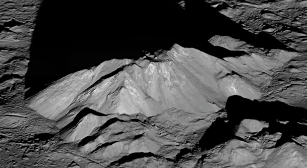
Take a "peak" into Tycho Crater!


To honor the Lunar Reconnaissance Orbiter’s amazing 1,000 days in science-filled orbit, the LRO team at Goddard Space Flight Center has created a wonderful video tour of the lunar surface like you’ve never seen it before!

[/caption]

“Tour of the Moon” takes viewers to several breathtaking locations on the Moon, including Orientale Basin, Shackleton crater, Tycho crater, Aristarchus Plateau, Mare Serenitatis, Compton-Belkovich volcano, Tsiolkovsky crater and more. The fully narrated video is above, and clips from each of the stops on the tour are available in many other formats here.

In addition, another video highlighting the dramatic evolution of the Moon was released today… you can view the full narrated version in 2D and stereoscopic 3D here.

iPad owners can also download the NASA Viz app to see this and other NASA stories, updated twice a week.

Credit: NASA Goddard Space Flight Center

Revisiting The First Rover

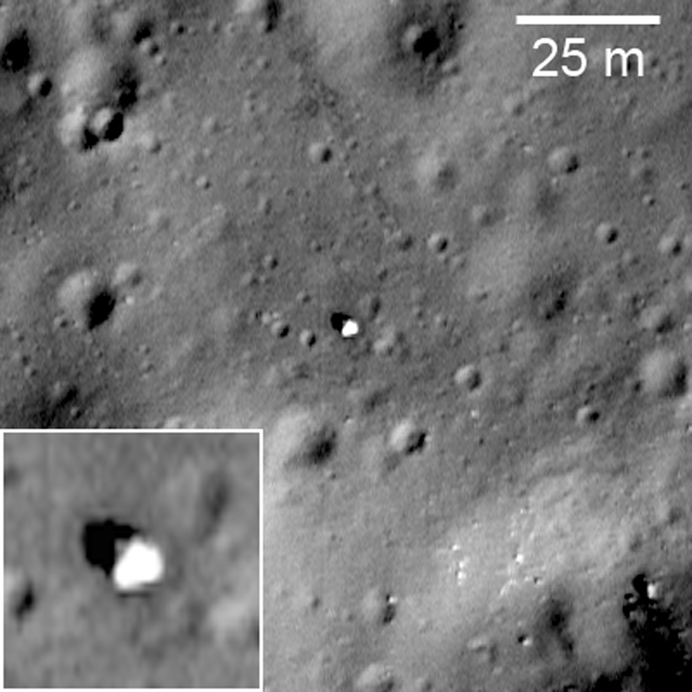
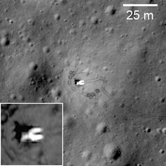
LROC image of Lunokhod 1 (NASA/GSFC/ASU)

[/caption]

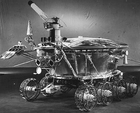
Before there was Curiosity, before Spirit, and Opportunity, and even long before Sojourner, there was Lunokhod 1, the Soviet Union’s lunar rover that explored Mare Imbrium from November of 1970 to September the following year. It was a curious-looking machine, a steampunk fantasy reminiscent of something out of a Jules Verne novel. But until the Mars Exploration Rovers nearly 40 years later, Lunokhod 1 held the record for the longest-operating robotic rover on the surface of another world.

These images from the Lunar Reconnaissance Orbiter Camera (LROC) are the most detailed yet of the now-silent Soviet rover and its lander, Luna 17.

The lander, Luna 17, was launched from Earth orbit on November 10, 1970, and entered lunar orbit five days later. It successfully soft-landed in Mare Imbrium on November 17 and deployed the Lunokhod (“moon walker” in Russian) rover, which was powered by batteries that were recharged via solar power during the lunar day.

Luna 17 and Lunokhod 1's tracks. (NASA/GSFC/ASU)

The 5600 kg (12,345 lb.) Lunokhod 1 boasted a suite of scientific tools for exploring the lunar surface. It was equipped with a cone-shaped antenna, a highly directional helical antenna, four television cameras, and special extendable devices to impact the lunar soil for soil density and mechanical property tests.

An x-ray spectrometer, an x-ray telescope, cosmic-ray detectors, and a laser device were also included.

The super-steampunk Lunokhod 1 rover. (NASA/GSFC)

Operating for nearly 300 days — almost four times longer than planned — by the time it officially ceased operations in October 1971 Lunokhod 1 had traveled 10,540 meters and had transmitted more than 20,000 images, and had conducted over 500 lunar soil tests.

The images above were obtained during a low-altitude pass by LRO, which came within 33 km (20.5 miles) of the lunar surface.

Via the LROC site by Arizona State University.

Luna 17 seen from Lunokhod 1