Were Lunar Volcanoes Active When Dinosaurs Roamed the Earth?

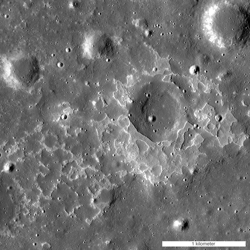
The feature called Maskelyne is one of many newly discovered young volcanic deposits on the moon. Called irregular mare patches, these areas are thought to be remnants of small lava eruptions that occurred recently in the moon's past. To view this image correctly, the large, dark, circular feature right of center is pancake-like dome that rises ABOVE the surrounding lighter-toned terrain. Lower domes, many pitted with small craters, are seen from left to right across the photo. Credit: NASA/GSFC/Arizona State University

The Moon’s a very dusty museum where the exhibits haven’t changed much over the last 4 billion years. Or so we thought. NASA’s Lunar Reconnaissance Orbiter (LRO) has provided researchers strong evidence the Moon’s volcanic activity slowed gradually instead of stopping abruptly a billion years ago.

Some volcanic deposits are estimated to be 100 million years old, meaning the moon was spouting lava when dinosaurs of the Cretaceous era were busy swatting giant dragonflies. There are even hints of 50-million-year-old volcanism, practically yesterday by lunar standards.
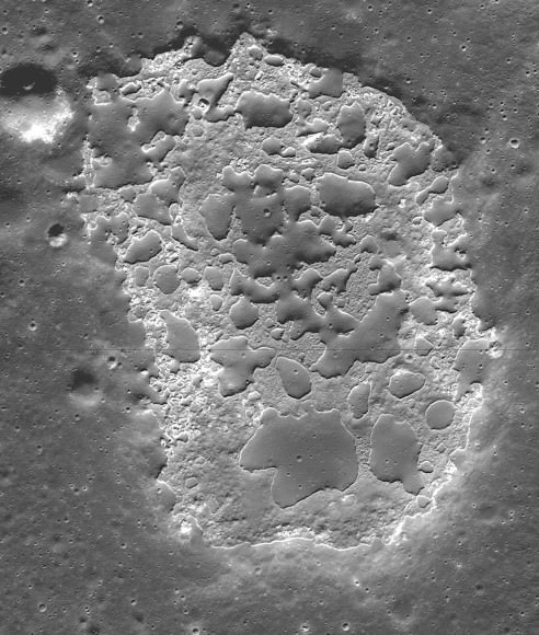
Ina Caldera sits atop a low, broad volcanic dome or shield volcano, where lavas once oozed from the moon’s crust. The darker patches in the photo are blobs of older lunar crust. As in the photo of Maskelyne, they form a series of low mounds higher than the younger, jumbled terrain around them. Credit: NASA

The deposits are scattered across the Moon’s dark volcanic plains (lunar “seas”) and are characterized by a mixture of smooth, rounded, shallow mounds next to patches of rough, blocky terrain. Because of this combination of textures, the researchers refer to these unusual areas as “irregular mare patches.”

Measuring less than one-third mile (1/2 km) across, almost all are too small to see from Earth with the exception of Ina Caldera, a 2-mile-long D-shaped patch where blobs of older, crater-pitted lunar crust (darker blobs) rise some 250 feet above the younger, rubbly surface like melted cheese on pizza.
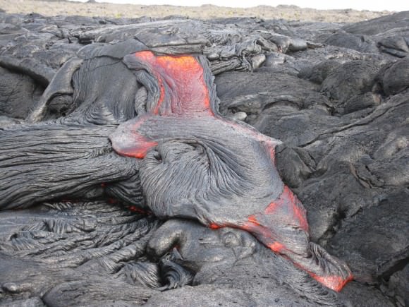
Lavas on the moon were thin and runny like this flow photographed in Kilauea, Hawaii. Credit: USGS

Ina was thought to be a one-of-a-kind until researchers from Arizona State University in Tempe and Westfälische Wilhelms-Universität Münster in Germany spotted 70 more patches in close-up photos taken by the LRO. The large number and the fact that the patches are scattered all over the nearside of the Moon means that volcanic activity was not only recent but widespread.

Astronomers estimate ages for features on the moon by counting crater numbers and sizes (the fewer seen, the younger the surface) and the steepness of the slopes running from the tops of the smoother domes to the rough terrain below (the steeper, the younger).

“Based on a technique that links such crater measurements to the ages of Apollo and Luna samples, three of the irregular mare patches are thought to be less than 100 million years old, and perhaps less than 50 million years old in the case of Ina,” according to the NASA press release.
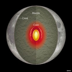
Artist concept illustration of the internal structure of the moon. Credit: NOAJ

The young mare patches stand in stark contrast to the ancient volcanic terrain surrounding them that dates from 3.5 to 1 billion years ago.

For lava to flow you need a hot mantle, the deep layer of rock beneath the crust that extends to the Moon’s metal core. And a hot mantle means a core that’s still cranking out a lot of heat.

Scientists thought the Moon had cooled off a billion or more years ago, making recent flows all but impossible. Apparently the moon’s interior remained piping hot far longer than anyone had supposed.

“The existence and age of the irregular mare patches tell us that the lunar mantle had to remain hot enough to provide magma for the small-volume eruptions that created these unusual young features,” said Sarah Braden, a recent Arizona State University graduate and the lead author of the study.
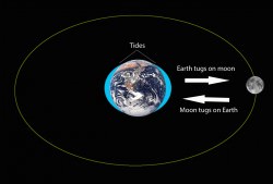
It takes two to tango. The moon’s gravity raises a pair of watery bulges in the Earth’s oceans creating the tides, while Earth's gravity stretches and compresses the moon to warm its interior. Illustration: Bob King
It takes two to tango. The moon’s gravity raises a pair of watery bulges in the Earth’s oceans creating the tides, while Earth’s gravity stretches and compresses the moon to warm its interior. Illustration: Bob King

One way to keep the Moon warm is through tidal interaction with the Earth. A recent study points out that strains caused by Earth’s gravitational tug on the Moon (nearside vs. farside) heats up its interior. Could this be the source of the relatively recent lava flows?

So the pendulum swings. Prior to 1950 it was thought that lunar craters and landforms were all produced by volcanic activity. But the size and global distribution of craters – and the volcanoes required to produce them – would be impossible on a small body like the Moon. In the 1950s and beyond, astronomers came to realize through the study of nuclear bomb tests and high-velocity impact experiments that explosive impacts from asteroids large and small were responsible for the Moon’s craters.

This latest revelation gives us a more nuanced view of how volcanism may continue to play a role in the formation of lunar features.

Mars Has Watery Insides, Just Like Earth

Researchers from the Carnegie Institution have found that water is present in surprisingly Earthlike amounts within Mars’ mantle, based on studies of meteorites that originate from the Red Planet. The findings offer insight as to how Martian water may have once made its way to the planet’s surface, as well as what may lie within other terrestrial worlds.

Earth has water on its surface (obviously) and also within its crust and mantle. The water content of Earth’s upper mantle — the layer just below the crust —  is between 50 and 300 ppm (parts per million). This number corresponds to what the research team has identified within the mantle of Mars, based on studies of two chunks of rock — called shergottites — that were blasted off Mars during an impact event 2.5 million years ago.

“We analyzed two meteorites that had very different processing histories,” said Erik Hauri, the analysis team’s lead investigator from the Carnegie Institute . “One had undergone considerable mixing with other elements during its formation, while the other had not. We analyzed the water content of the mineral apatite and found there was little difference between the two even though the chemistry of trace elements was markedly different. The results suggest that water was incorporated during the formation of Mars and that the planet was able to store water in its interior during the planet’s differentiation.”

The water stored within Mars’ mantle may have made its way to the surface through volcanic activity, the researchers suggest, creating environments that were conducive to the development of life.

Like Earth, Mars may have gotten its water from elements available in the neighborhood of the inner Solar System during its development. Although Earth has retained its surface water while that on Mars got lost or frozen, both planets appear to have about the same relative amounts tucked away inside… and this could also be the case for other rocky worlds.

“Not only does this study explain how Mars got its water, it provides a mechanism for hydrogen storage in all the terrestrial planets at the time of their formation,” said former Carnegie postdoctoral scientist Francis McCubbin, who led the study.

The team’s research is published in the July edition of the journal Geology. Read more on the Carnegie Institution for Science’s site here.

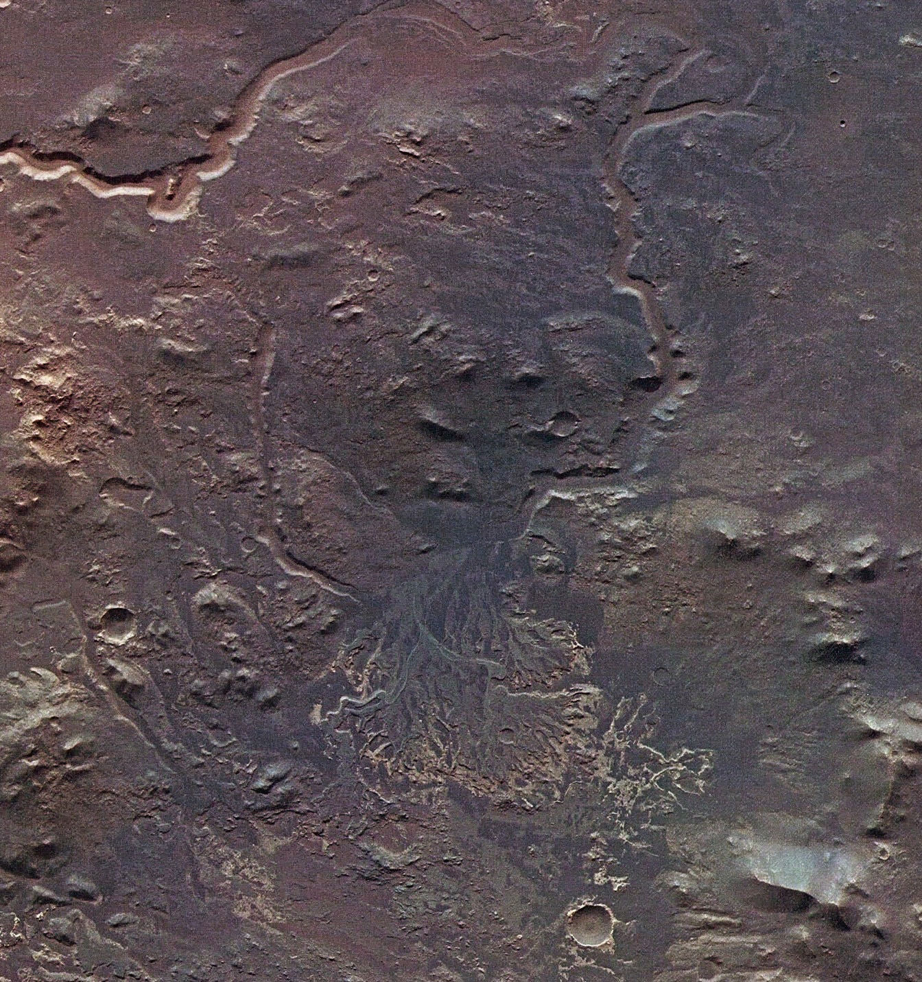
Image: The remains of what appears to be a river delta within Eberswalde crater on Mars, imaged by ESA’s Mars Express. Credit: ESA/DLR/FU Berlin (G. Neukum).

Earth’s Layers For Kids

My son recently came back from a science day camp with one of the coolest things. It was a model of the Earth that he had created out of modeling clay. It showed the internal structure of the Earth, and because he built it, he was able to remember all of the layers of the Earth. Very cool. So here’s a good way to learn the Earth layers for kids.

To make your own, you need some modeling clay of different colors. You start by making a ball about 1.2 cm across. This represents the Earth’s inner core. Then you make a second ball about 3 cm across. This ball represents the Earth’s outer core. Then you make a third ball about 6 cm across. This ball represents the Earth’s mantle. And finally, you make some flattened pieces of clay that will be the Earth’s crust. To make it extra realistic, make some pieces blue and others green.

Take inner core and surround it with the outer core, and then surround that by the mantle. Cover the entire mantle with a thin layer of blue, and then put on some green continents on top of the blue.

If you’ve been really careful, you should be able to take a sharp knife and slice your Earth ball in half. You should be able to see the Earth’s layers inside, just like you’d see the real Earth’s layers. And you can see that the mantle is thicker underneath the Earth’s continents than it is under the oceans.

Here’s a link with more information from Purdue University so you can do the experiment yourself.

If you’re interested in teaching your children Earth science, here’s lots of information about volcanoes for kids.

We have also recorded a whole episode of Astronomy Cast just about Earth. Listen here, Episode 51: Earth.

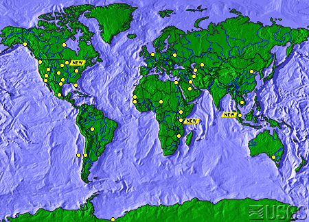
Mantle Plume

Hotspot

[/caption]
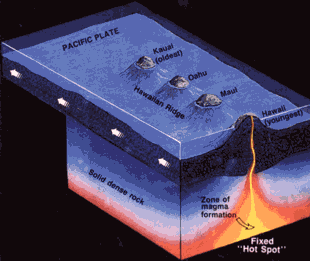
One of the mysteries of Earth science is hotspots. While most volcanoes are found at plate boundaries, where two tectonic plates are rubbing against each other, volcanic hotspots can be anywhere, even in the middle of continents. What causes volcanic hotspots? One theory is the idea of a mantle plume.

A mantle plume is kind of like what’s going on inside a lava lamp. As the light heats up the wax in a lava lamp, it rises up through the oil in large blobs. These blobs reach the top of the lamp, cool and then sink back down to be heated up again.

Inside the Earth, the core of the Earth is very hot, and heats up the surrounding mantle. Heat convection in the mantle slowly transports heat from the core up to the Earth’s surface. These rising columns of heat can come up anywhere, and not just at the plate boundaries. Geologists did fluid dynamic experiments to try and simulate mantle plumes, and they found they formed long thin conduits topped by a bulbous head.

When the top of a mantle plume reaches the base of the Earth’s lithosphere, it flattens out and melts a large area of basalt magma. This whole region can form a continental flood basalt, which only lasts for a few million years. Or it can maintain a continuous stream of magma to a fixed location; this is a hotspot.

As the lithosphere continues to move through plate tectonics, the hotspot appears to be shifting its position over millions of years. But really the hotspot is remaining in a fixed location, and the Earth’s plates are shifting above it.

Two of the most famous places that might have mantle plumes underneath them are the Hawaiian Islands and Iceland.

We have written many articles about volcanoes and the interior of the Earth for Universe Today. Here’s an article about the difference between magma and lava, and here’s an article about magma chambers.

Here’s a great resource on mantle plumes, and here’s another.

We have recorded an entire episode of Astronomy Cast about volcanoes around the Solar System. Listen to it here: Episode 141: Volcanoes, Hot and Cold.

Continental Drift Theory

Map showing some of the continents

In elementary school, every teacher had one of those pull-down maps of the world to teach geography. On occasion, I thought the largest land masses, known as continents, reminded me of pieces in a jigsaw puzzle. They just seemed like they should fit together, somehow. Not until I took Earth Science, in 8TH grade, did I discover my earlier idea was correct. My teacher explained about a phenomenon, known as, The Continental Drift Theory. He said that some German had the same idea I did.

The man my teacher mentioned, Alfred Wegener (Vay gen ner), developed The Continental Drift Theory in 1915. He was a meteorolgist and a geologist. His theory basically said that, at one time, there existed one large supercontinent, called, Pangea, pan, meaning all-encompassing, and, gea, meaning the Earth. He went on to suggest that, seismic activity, such as erthquakes, volcanic eruptions, and tsunamis, also called tidal waves, eventually created fissures, or cracks in the Earth. As these fissures became larger, longer, and deeper, 7 pieces of Pangea broke off and, over time, drifted to the places where they are now. These 7 large pieces of land are what we now call, continents. They are: North America; South America; Europe; Asia; Africa; Antarctica; and, Australia. Some people refer to the country as Australia, and the continent as, Oceania. They do this because there are other countries, such as New Zealand, included as a part of that particular continent.

At the time, people thought Wegener was, well, “nuts.” Only in the 1950s did people begin to take his idea seriously. According to the United States Geological Survey (the USGS), thanks to the use of the submarine and the technology developed during World War II, scientists learned a lot about the Ocean Floor. When they found out that it was not as old as the Crust, or Surface, of the Earth, sicentists had to ask themselves, “Why?”

The answers have to do with earthquakes, volcanoes, and magnetism. When the Earth cracks, molten magma, from the middle of the Earth, known as the Mantle, works its way to the surface, where it becomes known as, lava. That lava melts away some of the older layers; then, when the water cools that lava, it forms a new layer of Earth. For that reason, if scientists tried to determine the age of the Earth from samples taken from the Ocean Floor, they would be very wrong.

That same equipment also helped scientists recognize that heavy amounts of basalt, a volcanic rock that contains high amounts of iron, could throw compasses off course. This information provided one more pieces to the puzzle. Now, scientists recognize that the North and South Poles were not always where they currently are.

The Earth changes every day. Although we might not notice it, the continents move all the time. We don’t only revolve, or spin, around the Sun. We also drift across the surface of the planet.

The United States Geological Survey has some excellent information on this topic.

University Today has some other fabulous material about this and related topics, including Earth, Barely Habitable?, by Fraser Cain begin_of_the_skype_highlighting     end_of_the_skype_highlighting, and Interesting Facts About Planet Earth.

You can also read or listen to Episode 51: Earth, of Astronomy Cast, also produced by Universe Today.

Sources:
http://en.wikipedia.org/wiki/Continental_drift
http://www.ucmp.berkeley.edu/history/wegener.html
http://pubs.usgs.gov/gip/dynamic/historical.html