Opportunity Rover Starts Year 10 on Mars with Remarkable Science Discoveries

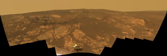
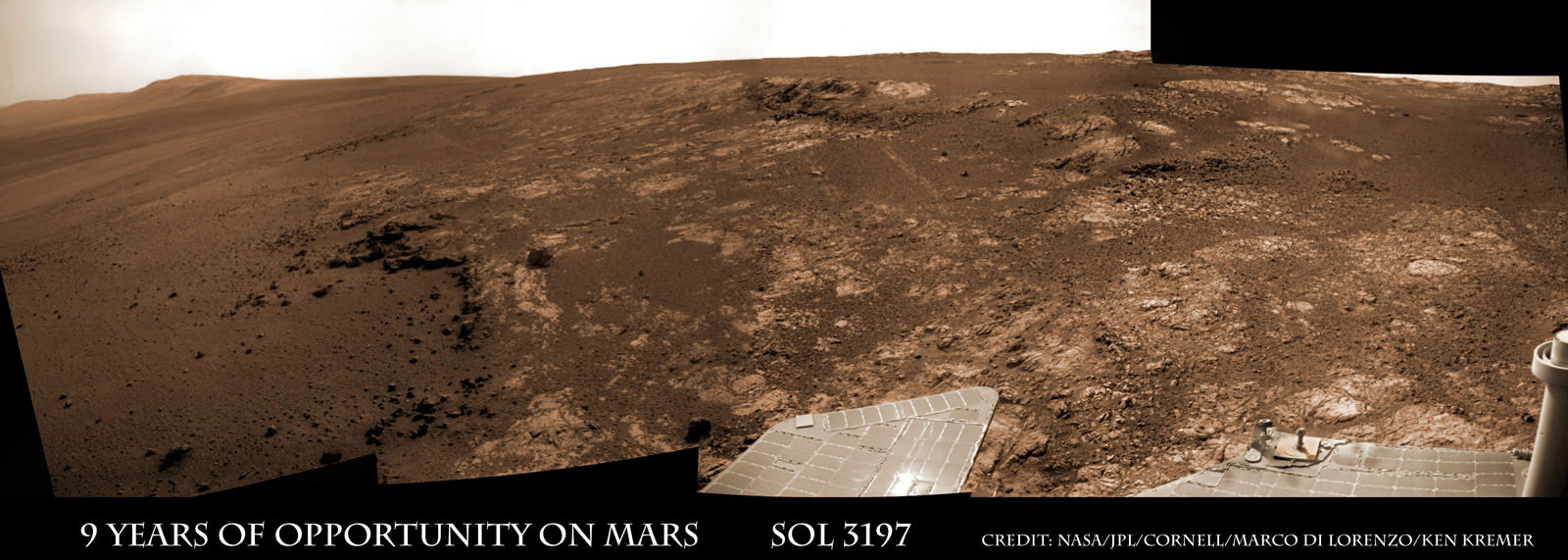
Image caption: Opportunity Celebrates 9 Years and 3200 Sols on Mars snapping this panoramic view from her current location on ‘Matijevic Hill’ at Endeavour Crater. The rover discovered phyllosilicate clay minerals and calcium sulfate veins at the bright outcrops of ‘Whitewater Lake’, at right, imaged by the Navcam camera on Sol 3197 (Jan. 20, 2013). “Copper Cliff” is the dark outcrop, at top center. Darker “Kirkwood” outcrop, at left, is site of mysterious “newberries” concretions. Credit: NASA/JPL-Caltech/Cornell/Marco Di Lorenzo/Ken Kremer

9 Years ago, NASA’s pair of identical twin sister rovers – christened Spirit & Opportunity- bounced to daunting airbag-cushioned landings on opposite sides of the Red Planet for what was supposed to be merely 90 day missions, or maybe a little bit longer scientists hoped.

Today, Opportunity celebrates a truly unfathomable achievement, starting Year 10 on Mars since she rolled to a bumpy stop on January 24, 2004 inside tiny Eagle crater. And she’s now at a super sweet spot for science (see our photo mosaic above) loaded with clays and veined minerals and making the most remarkable findings yet about the planets watery past – thus building upon a long string of previously unthinkable discoveries due to her totally unforeseen longevity.

“Regarding achieving nine years, I never thought we’d achieve nine months!” Principal Investigator Prof. Steve Squyres of Cornell University told Universe Today for this article commemorating Opportunity’s 9th anniversary.

Opportunity reached 3200 Sols, or Martian days, and counting , by her 9th birthday. She is now 108 months into the 3 month primary mission – that’s 36 times longer than the 3 month “warranty.”

“Every sol is a gift,” Squyres told me. He always refers to the rovers as our “Priceless assets on Mars”, that have to be taken good care of to wring out the maximum science data possible and for as long as humanly, or more aptly, robotically possible.

PIA16703_Sol3137B_Matijevic_Pan_L257atc_br2

Image Caption: ‘Matijevic Hill’ Panorama for Rover’s Ninth Anniversary. As Opportunity neared the ninth anniversary of its landing on Mars, the rover was working in the ‘Matijevic Hill’ area seen in this view from Opportunity’s panoramic camera (Pancam). Two of the features investigated at Matijevic Hill are “Copper Cliff,” the dark outcrop in the left center of the image, and “Whitewater Lake,” the bright outcrop on the far right. The component images for this mosaic were taken from Sol 3137 (Nov. 19, 2012) through Sol 3150 (Dec. 3, 2012). Credit: NASA/JPL-Caltech/Cornell/Arizona State Univ.

The resilient, solar powered Opportunity robot begins her 10th year roving around beautifully Earth-like Martian terrain where where she proved that potentially life sustaining liquid water once flowed billions of years ago when the planet was warmer and wetter.

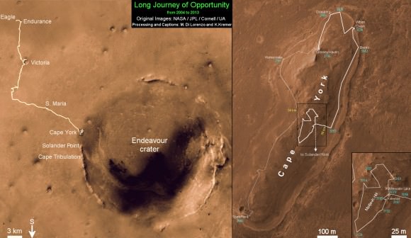
Opportunity is healthy and has driven over 22 miles (35 kilometers )- marking the first overland expedition on another planet. See our photo mosaics and route map by Ken Kremer and Marco Di Lorenzo.

She is now working at the inboard edge of “Cape York” – a hilly segment of the eroded rim of 14 mile (22 km) wide Endeavour Crater, featuring terrain with older rocks than previously inspected and unlike anything studied before. It’s a place no one ever dared dream of reaching prior to launch in the summer of 2003 and landing on the Meridiani Planum region of Mars.

“It’s like a whole new mission since we arrived at Cape York,” says Squyres.

Opportunity Sol 3182_3Ba_Ken Kremer

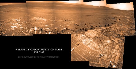
Image caption: Opportunity Celebrates 9 Years on Mars snapping this panoramic view of the vast expanse of 14 mile (22 km) wide Endeavour Crater from atop ‘Matijevic Hill’ on Sol 3182 (Jan. 5, 2013). The rover then drove 43 feet to arrive at ‘Whitewater Lake’ and investigate clay minerals. Photo mosaic was stitched from Navcam images and colorized. Credit: NASA/JPL-Caltech/Cornell/Ken Kremer/Marco Di Lorenzo

Today Opportunity is poised for breakthrough science at deposits of phyllosilicates – clay minerals which stem from an earlier epoch when liquid water flowed on Mars eons ago and perhaps may have been more favorable to sustaining microbial life because they form in more neutral pH water. Endeavour Crater is more than 3 Billion years old.

I asked Squyres to discuss the discovery of the phyllosilicates – which have never before been analyzed up close on the Martian surface and are actually a main target of NASA’s new Curiosity rover at Gale Crater.

“We have found the phyllosilicates at Cape York: they’re in the Whitewater Lake materials,” Squyres explained. Spectral data collected from Mars orbit by the CRISM spectrometer aboard NASA’s MRO circling spacecraft allowed the researchers to direct Opportunity to this exact spot.

“Whitewater Lake” is an area of bright local outcrops currently being investigated and providing information about a different and apparently less acidic environment compared to other areas and craters visited earlier in the mission – and potentially more conducive to life.

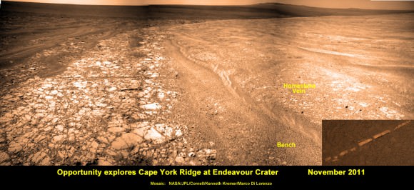
Opportunity also discovered more mineral veins at “Whitewater Lake”, in addition to those hydrated mineral veins discovered earlier at Cape York at a spot named “Homestake” – see our mosaic below.

“We have investigated the veins in these materials, and we have determined that they are calcium sulfate,” Squyres confirmed to me.

Opportunity Sol 2761_2a_Ken Kremer

Image caption: Opportunity discovers hydrated Mineral Vein at Endeavour Crater – November 2011. Opportunity determined that the ‘Homestake’ mineral vein was composed of calcium sulfate,or gypsum, while exploring around the base of Cape York ridge at the western rim of Endeavour Crater. The vein discovery indicates the ancient flow of liquid water at this spot on Mars. This panoramic mosaic of images was taken on Sol 2761, November 2011, and illustrates the exact spot of the mineral vein discovery. Featured on NASA Astronomy Picture of the Day (APOD) on 12 Dec 2011. Credit: NASA/JPL/Cornell/Kenneth Kremer/Marco Di Lorenzo.

How do the new mineral veins compare to those at ‘Homestake’ and those just found by Curiosity at Yellowknife Bay inside Gale crater? I asked Sqyures.

“Much narrower, and possibly older,” he said compared to the Homestake calcium sulfate veins .

“It’s too early to say how they compare to the veins at Gale, though.”

The local area at “Cape York” is called “Matijevic Hill” – in honor of a recently deceased team member who played a key role on NASA’s Mars rovers.

The rover has already spent a few months at “Matijevic Hill” on a ‘walk about’ scouting survey and also found concretions dubbed “newberries” that are different from the “blueberry” concretions found earlier in the mission.

How widespread are the phyllosilicates ?

“Matijevic Hill is the only exposure of phyllosilicates we know of at Cape York, so in order to find more we’re going to have to go elsewhere,” Squyres replied. “We haven’t figured out what the “newberries” are yet, but attempting to do that will be our next task.”

It is likely to take many more weeks and even months to “figure out” what this all means for science.

Therefore, no one should expect the robot to move much in the near future. Since the rover made landfall at the western rim of Endeavour crater at Spirit Point in August 2011, she has been circling around Cape York ever since.

Opportunity Sol 2678c_Ken Kremer

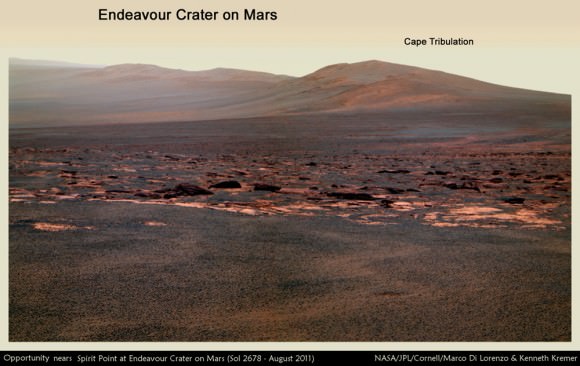
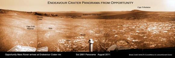
Image caption: Opportunity rover first arrived at the western rim of Endeavour Crater (14 miles, 22 km wide) in August 2011. This photo mosaic of navcam images shows portions of the segmented rim of Endeavour crater on Sol 2678. Large ejecta blocks from a smaller nearby crater are visible in the middle. At Endeavour, Opportunity will investigate the oldest minerals deposits she has ever visited from billions of years ago and which may hold clues to environments that were potentially habitable for microbial life. The rover may eventually drive to Cape Tribulation at right if she survives. Credit: NASA/JPL/Cornell/Marco Di Lorenzo/Ken Kremer (kenkremer.com)

What is the next destination for Opportunity?

“Once we’re done at Cape York, our next destination will be Solander Point [to the south],” Squyres confirmed. It’s the next rim segment south of Cape York (see map).

Eventually, if Opportunity continues to function and survives the next Martian winter, she may be directed several miles even further south, along the crater rim to a spot called Cape Tribulation – because it also harbors caches of phyllosilicate clay minerals. But there is no telling when that might be.

“One step at a time,” said Squyres as always. He is not making any guesses or predictions. The mission is totally discovery driven.

Well after so many great science discoveries over the past 9 years, I asked Squyres to describe the context and significance of the phyllosilicates discovery?

“Impossible to say, I’m afraid… we’re still figuring this place out; I can’t put it in context yet,” Squyres concluded.

Thus, there is still so much more bountiful science research still to be done by Opportunity – and nobody is making any forecasts on how long she might yet survive.

So just keep praying to the Martian weather gods for occasional winds and “dust devils” to clean off those life giving solar panels – and to the US Congress to provide the essential funding.

Ken Kremer

Opportunity Sol 2852a_Ken Kremer

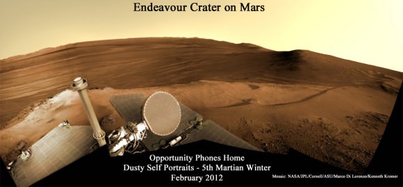
Image caption: Opportunity Phones Home – Dusty Self Portrait from Endeavour Crater on Mars on Sol 2852, February 2012. NASA’s rover Opportunity snaps self-portrait where she endured 5th frigid Martian winter at Greeley Haven. Opportunity is currently investigating Cape York ridge and Matijevic Hill at right. Vast expanse of Endeavour Crater and rim in background with dusty solar panels and full on view of the High Gain Antenna (HGA) in the foreground. Mosaic: NASA/JPL/Cornell/ASU/Marco Di Lorenzo/Ken Kremer

Opportunity Sol 2681a_annotated_Ken Kremer

Image caption: Endeavour Crater Panorama from Opportunity, Sol 2681, August 2011 on arrival at the rim of Endeavour and Cape York ridge. Odyssey crater visible at left. Mineral veins were later found to surround Cape York. Credit: NASA/JPL/Cornell/Marco Di Lorenzo/Ken Kremer

Opportunity Route map_3187s_Ken Kremer

Image caption: Traverse Map for NASA’s Opportunity rover from 2004 to 2013 – shows the entire path the rover has driven over 9 years, 3200 Sols and more than 22 miles (35 km) from Eagle Crater landing site to current location at Cape York ridge at Endeavour Crater. Credit: NASA/JPL/Cornell/ASU/Marco Di Lorenzo/Ken Kremer (kenkremer.com)

Weekly Space Hangout – January 25, 2013

Back by popular demand… the Weekly Space Hangout has returned. This is a weekly broadcast on Google+, where I’m joined by a wide and varied team of space and astronomy journalists to discuss the big breaking stories this week.

This week, we talked about:

We record the Weekly Space Hangout every Friday on Google+ at 12:00 pm PST / 3:00 pm EST / 2000 GMT. You’ll want to circle Cosmoquest on Google+ to find out when we’re recording next. The audio for the Weekly Space Hangout is also released to the Astronomy Cast podcast feed.

Curiosity’s Robotic Arm Camera Snaps 1st Night Images

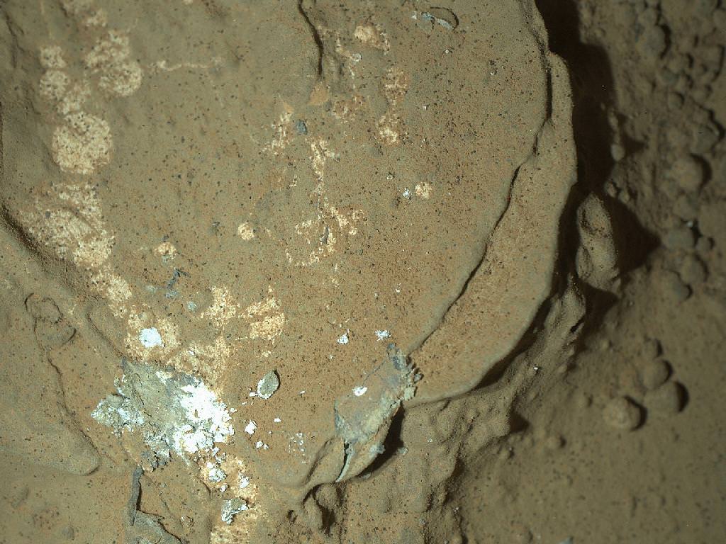
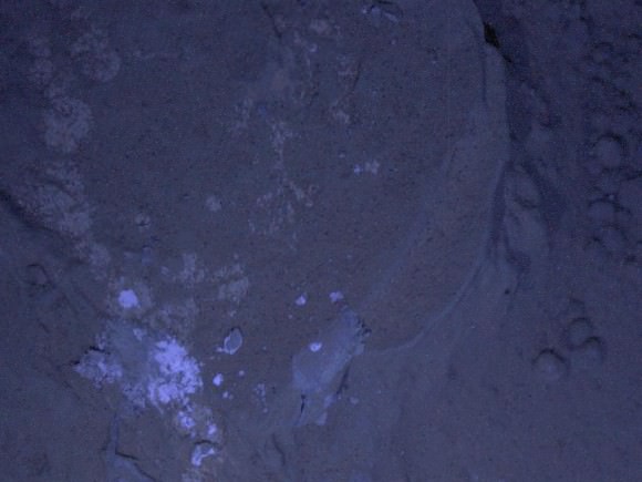
Image caption: This image of a Martian rock illuminated by white-light LEDs (light emitting diodes) is part of the first set of nighttime images taken by the Mars Hand Lens Imager (MAHLI) camera at the end of the robotic arm of NASA’s Mars rover Curiosity. The image was taken on Jan. 22, 2013, after dark on Sol 165. It covers an area about 1.3 inches by 1 inch (3.4 by 2.5 centimeters). Credit: NASA/JPL-Caltech/MSSS

Curiosity’s high resolution robotic arm camera has just snapped the 1st set of night time images of a Martian rock of the now 5 1/2 month long mission – using illumination from ultraviolet and white light emitting LED’s. See the images above and below.

The Mars Hand Lens Imager (MAHLI) camera is located on the tool turret at the end of Curiosity’s 7 foot (2.1 m) long robotic arm.

MAHLI took the close-up images of a rock target named “Sayunei” on Jan. 22 (Sol 165), located near the front-left wheel after the rover had driven over and scuffed the area to break up rocks in an effort to try and expose fresh material, free of obscuring dust.

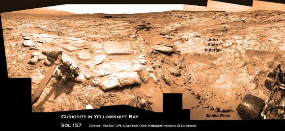
“Sayunei” is at the site of the “John Klein” outcrop in “Yellowknife Bay” where the team hopes to commence the 1st rock drilling operations here in the coming days. Curiosity drove a few meters several sols ago to reach “John Klein”.

See below our Sol 157 mosaic showing the “John Klein” outcrop – where the rover snapped these night images of “Sayunei”.

721606main_pia16712-43_1024-768

Image caption: This image of a Martian rock illuminated by ultraviolet LEDs (light emitting diodes) is part of the first set of nighttime images taken by the MAHLI camera on the robotic arm. The image was taken on Jan. 22, 2013, after dark on Sol 165. It covers an area about 1.3 inches by 1 inch (3.4 by 2.5 centimeters). Credit: NASA/JPL-Caltech/MSSS

“The purpose of acquiring observations under ultraviolet illumination was to look for fluorescent minerals,” said MAHLI Principal Investigator Ken Edgett of Malin Space Science Systems, San Diego. “These data just arrived this morning. The science team is still assessing the observations. If something looked green, yellow, orange or red under the ultraviolet illumination, that’d be a more clear-cut indicator of fluorescence.”

Analysis is still in progress to determine whether fluorescent minerals are present. Certain classes of organic compounds are also fluorescent.

MAHLI is an adjustable focus camera that works over a wide range. It can focus on targets just a few centimeters away or on distant objects like Mount Sharp, over 6 miles (10 km) away.

The LED’s surround the MAHLI lens.

Curiosity has discovered widespread evidence for the ancient flow of liquid water at “Yellowknife Bay” in the form of water bearing mineral veins, cross-bedded layering, nodules and spherical sedimentary concretions.

Ken Kremer

Curiosity & Yellowknife Bay Sol 157_4Ca_Ken Kremer

Image caption: Curiosity found widespread evidence for flowing water in the highly diverse, rocky scenery shown in this photo mosaic from the edge of Yellowknife Bay on Sol 157 (Jan 14, 2013). The rover will soon conduct 1st Martian rock drilling operation at flat, light toned rocks at the outcrop called “John Klein”, at center, the site where she is now located. ‘John Klein’ drill site and ‘Sheep Bed’ outcrop ledges to right of rover arm are filled with numerous mineral veins and spherical concretions which strongly suggest precipitation of minerals from liquid water. ‘Snake River’ rock formation is the linear chain of rocks protruding up from the Martian sand near rover wheel. Credit: NASA/JPL-Caltech/Ken Kremer/Marco Di Lorenzo

NASA Stars at 2013 Presidential Inaugural Parade with Orion and Curiosity – Photos and Video

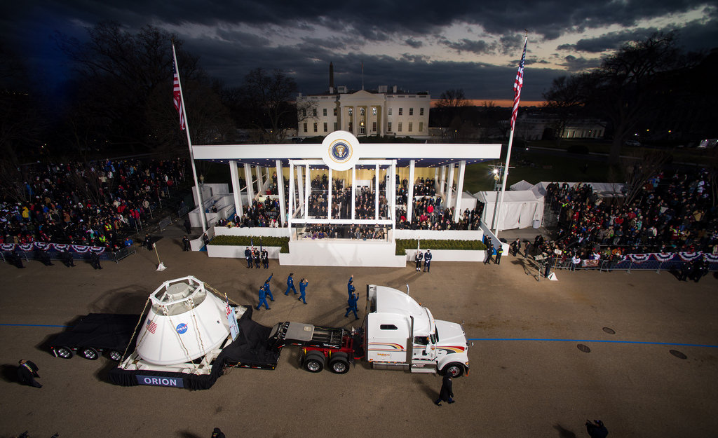
Image caption: Orion deep space crew capsule float passes in front of the White House at the Presidential Inaugural parade on Jan 21, 2013 in Washington, DC. Credit: NASA

NASA’s new Orion deep space crew capsule and sensational Curiosity Mars rover had starring roles at the 2013 Presidential Inaugural Parade held on Monday, Jan 21, 2013 in Washington D.C.

NASA photographers captured stunning photos and video (above and below) as Orion and Curiosity passed in front of the White House and the official reviewing stand – with President Obama & VP Joe Biden and their families and numerous dignitaries smiling and waving.

Beautiful weather shined though out the entire day’s festivities and into the early evening as full size models of Orion and Curiosity made their way thought the capitol streets to participate in the 2013 Inaugural parade.

NASA’s floats prominently placed near the front of the parade and seen on Live TV about 530 PM EDT as well as by about a million spectators on hand.

8403941024_d82bee7a00_b[1]

Image caption: Curiosity Mars rover float passes in front of the White House and reviewing stand at the Presidential Inaugural parade on Jan 21, 2013 in Washington, DC. Credit: NASA

The fantastically successful Curiosity rover is discovering widespread evidence for the ancient flow of liquid water on Mars.

The Orion multi-purpose capsule will take our astronauts back to the Moon and farther into deep space than ever before.

NASA is the ONLY federal agency asked to be in the inaugural parade. Curiosity led the way followed by Orion.


Video of full-size models of the Curiosity Mars rover and Orion, the multi-purpose capsule that will take our astronauts farther into space than ever, as they appeared in the Washington, D.C. parade on Jan. 21.

Accompanying the NASA vehicles were members of the Curiosity team from NASA’s Jet Propulsion Laboratory, and current and former astronauts Alvin Drew, Serena Aunon, Kate Rubins, Mike Massimino, Lee Morin and Kjell Lindgren, as well as Leland Melvin, NASA’s associate administrator for Education, and John Grunsfeld, NASA’s associate administrator for Science.

Be sure to check out NASA’s Flickr stream for many photos from the 2013 Inaugural Day festivities and parade – here and here

See my preview story – here

Ken Kremer

Watery Science ‘Jackpot’ Discovered by Curiosity

Curiosity found widespread evidence for flowing water in the highly diverse, rocky scenery shown in this photo mosaic from the edge of Yellowknife Bay on Sol 157 (Jan 14, 2013). The rover will soon conduct 1st Martian rock drilling operation at flat, light toned rocks at the outcrop called “John Klein”, at center. ‘John Klein’ drill site and ‘Sheep Bed’ outcrop ledges to right of rover arm are filled with numerous mineral veins and spherical concretions which strongly suggest precipitation of minerals from liquid water. ‘Snake River’ rock formation is the linear chain of rocks protruding up from the Martian sand near rover wheel. Credit: NASA/JPL-Caltech/Ken Kremer/Marco Di Lorenzo

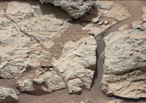
The Curiosity rover hit the science “jackpot” and has discovered widespread further evidence of multiple episodes of liquid water flowing over ancient Mars billions of years ago when the planet was warmer and wetter, scientists announced. The watery evidence comes in the form of water bearing mineral veins, cross-bedded layering, nodules and spherical sedimentary concretions.

Any day now NASA’s mega robot will be instructed to drill directly into veined rocks where water once flowed, the team announced at a media briefing this week.

Delighted researchers said Curiosity surprisingly found lots of evidence for light-toned chains of linear mineral veins inside fractured rocks littering the highly diverse Martian terrain – using her array of ten state-of-the-art science instruments. Veins form when liquid water circulates through fractures and deposit minerals, gradually filling the insides of the fractured rocks over time.

Sometime in the next two weeks or so, NASA’s car sized rover will carry out history’s first ever drilling inside a Martian rock that was “percolated” by liquid water – an essential prerequisite for life as we know. A powdered sample will then be delivered to the robots duo of analytical chemistry labs (CheMin & SAM) to determine its elemental composition and ascertain whether organic molecules are present.

The drill target area is named “John Klein” outcrop, in tribute to a team member who was the deputy project manager for Curiosity at JPL for several years and who passed away in 2011.

“We identified a potential drill target and are preparing to do drill activities in the next two weeks. We are ready to go,” said Richard Cook, the project manager of NASA’s Jet Propulsion Laboratory (JPL) in Pasadena, Calif.

“Drilling [into a rock] is the most significant engineering activity since landing. It is the most difficult aspect of the surface mission, interacting with an unknown surface terrain, and has never been done on Mars. We will go slowly. It will take some time to deliver samples to CheMin and SAM and will be a great set of scientific measurements.”

pia16705annotated-br2

Image caption: Mineral veins of calcium sulfate discovered by Curiosity at ‘Sheepbed’ Outcrop. These veins form when water circulates through fractures, depositing minerals along the sides of the fracture, to form a vein. These vein fills are characteristic of the stratigraphically lowest unit in the “Yellowknife Bay” area where Curiosity is currently exploring and were imaged on Sol 126 (Dec. 13, 2012) by the telephoto Mastcam camera. Image has been white-balanced. Credit: NASA/JPL-Caltech/MSSS

“The scientists have been let into the candy store,” said Cook referring to the unexpected wealth of science targets surrounding the rover at this moment.

“There is a high diversity of rocks types here to characterize,” added Mike Malin, Mastcam principal investigator of Malin Space Science Systems (MSSS). “We see layering, veins and concretions. The area is still undergoing some changes.”

Curiosity is just a few meters away from ‘John Klein’ and will drive to the site shortly from her location inside ‘Yellowknife Bay’ beside the ‘Snake River’ rock formation. To see where Curiosity is in context with ‘John Klein’ and “Snake River’, see our annotated context mosaic (by Ken Kremer & Marco Di Lorenzo) as the rover collects data at a rock ledge.

The white colored veins were discovered over the past few weeks- using the high resolution mast- mounted imaging cameras and ChemCam laser firing spectrometer -at exactly the vicinity where Curiosity is currently investigating ; around a shallow basin called Yellowknife Bay and roughly a half mile away from the landing site inside Gale Crater.

“This lowest unit that we are at in Yellowknife Bay, the very farthest thing we drove to, turns out to be kind of the ‘jackpot’ unit here,” said John Grotzinger, the mission’s chief scientist of the California Institute of Technology. “It is literally shot through with these fractures and vein fills.”

pia16567-43[1]

Image caption: ‘John Klein’ Site Selected for Curiosity’s Drill Debut. This view shows the patch of veined, flat-lying rock selected as the first drilling site. The rover’s right Mast Camera equipped with a telephoto lens, was about 16 feet (5 meters) away from the site when it recorded this mosaic on sol 153 (Jan. 10, 2013). The area is shot full of fractures and veins, with the intervening rock also containing concretions, which are small spherical concentrations of minerals. Enlargement A shows a high concentration of ridge-like veins protruding above the surface. Some of the veins have two walls and an eroded interior. Enlargement B shows that in some portions of this feature, there is a horizontal discontinuity a few centimeters or inches beneath the surface. The discontinuity may be a bed, a fracture, or potentially a horizontal vein. Enlargement C shows a hole developed in the sand that overlies a fracture, implying infiltration of sand down into the fracture system. Image has been white-balanced. Credit: NASA/JPL-Caltech/MSSS

Shortly after landing the team took a calculated gamble and decided to take a several months long detour away from the main destination of the towering, sedimentary mountain named Mount Sharp, and instead drive to an area dubbed ‘Glenelg’ and home to ‘Yellowknife Bay’, because it sits at the junction of a trio of different geologic terrains. Glenelg exhibits high thermal inertia and helps put the entire region in better scientific context. The gamble has clearly payed off.

“We chose to go there because we saw something anomalous, but wouldn’t have predicted any of this from orbit,” said Grotzinger.

The Chemistry and Camera (ChemCam) instrument found elevated levels of calcium, sulfur and hydrogen. Hydrogen is indicative of water.

The mineral veins are probably comprised of calcium sulfate – which exists in several hydrated (water bearing) forms.

“The ChemCam spectra point to a composition very high in calcium. These veins are likely composed of hydrated calcium sulfate, such as bassinite or gypsum, depending on the hydration state,” said ChemCam team member Nicolas Mangold of the Laboratoire de Planétologie et Géodynamique de Nantes in France. “On Earth, forming veins like these requires water circulating in fractures and occur at low to moderate temperatures.”

The newly found veins appear quite similar to analogous veins discovered in late 2011 by NASA’s Opportunity rover – Curiosity’s older sister – inside Endeavour crater and nearly on the opposite side of Mars. See our Opportunity vein mosaic featured at APOD on Dec. 11, 2011 to learn more about veined rocks.

“What these vein fills tell us is water moved and percolated through these rocks, through these fracture networks and then minerals precipitated to form the white material which ChemCam has concluded is very likely a calcium sulfate, probably hydrated in origin,” Grotzinger explained.

“So this is the first time in this mission that we have seen something that is not just an aqueous environment, but one that also results in precipitation of minerals, which is very attractive to us.”

Yellowknife Bay and the ‘John Klein’ drilling area outcrop are chock full of mineral veins and sedimentary concretions.

“When you put all this together it says that basically these rocks were saturated with water. There may be several phases to this history of water, but that’s still to be worked out.”

“This has been really exciting and we can’t wait to start drilling,” Grotzinger emphasized.

Curiosity can drill about 2 inches (5 cm) into rocks. Ultimately a powdered sample about half an aspirin tablet in size will be delivered to SAM and CheMin after a few weeks. All rover systems and instruments are healthy, said Cook.

Grotzinger said that Curiosity will be instructed to drive over the veins to try and break them up and expose fresh surfaces for analysis. Then she will drill directly into a vein and hopefully catch some of the surrounding material as well.

“This will reveal the mineralogy of the vein filling material and how many hydrated mineral phases are present. The main goal is this will give us an assessment of the habitability of this environment.”

As the rover has driven down the shallow depression to deeper stratigraphic layers, the units are older in time.

After the first drill sample is fully analyzed, Grotzinger told me that the team will reevaluate whether to drill into a second rock.

The team doesn’t yet know whether the flowing water from which the veins precipitated was a more neutral pH or more acidic. “It’s too early to tell. We need to drill into the rock to tell and determine the mineralogy,” Grotzinger told me. Neutral water is more hospitable to life.

How long the episodes of water flowed is not yet known and it’s a complex history. But the water was at least hip to ankle deep at times and able to transport and round the gravel.

“There are a broad variety of sedimentary rocks here, transported from elsewhere. Mars was geologically active in this location, which is totally cool !,” said Aileen Yingst, MAHLI deputy principal investigator. ”There are a number of different transport mechanisms in play.”

719254main_pia16708-43_946-710

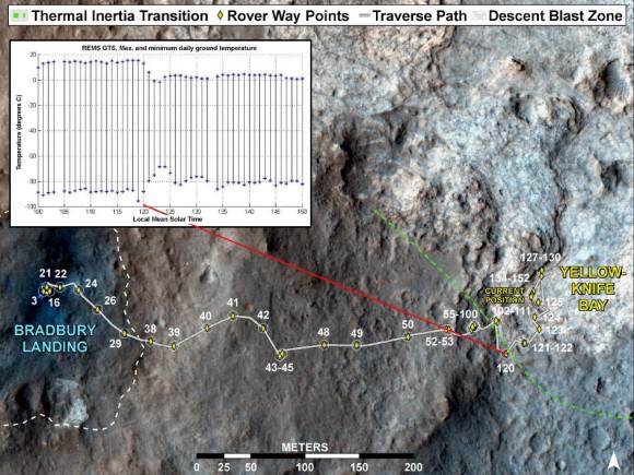
Image caption: Curiosity’s Traverse into Different Terrain. This image maps the traverse of NASA’s Mars rover Curiosity from “Bradbury Landing” to “Yellowknife Bay,” with an inset documenting a change in the ground’s thermal properties with arrival at a different type of terrain. credit: NASA/JPL-Caltech/Univ. of Arizona/CAB(CSIC-INTA)/FMI

Drilling goes to the heart of the mission and will mark a historic feat in planetary exploration – as the first time that an indigenous sample has been cored from the interior of a rock on another planet and subsequently analyzed by chemical spectrometers to determine its elemental composition and determine if organic molecules are present .

The high powered hammering drill is located on the tool turret at the end of the car-sized robots 7 foot (2.1 meter) long mechanical arm . It is the last of Curiosity’s ten instruments that remains to be checked out and put into action.

Curiosity landed on the Red Planet five months ago inside Gale Crater to investigate whether Mars ever offered an environment favorable for microbial life, past or present and is now nearly a quarter of the way through her two year prime mission.

Curiosity might reach the base of Mount Sharp by the end of 2013, which is about 6 miles (10 km) away as the Martian crow flies.

Ken Kremer

718888main_pia16615-43_946-710

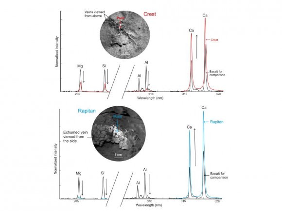
Image Caption: Calcium-Rich Veins in Martian Rocks. This graphic shows close-ups of light-toned veins in rocks in the “Yellowknife Bay” area of Mars together with analyses of their composition. The top part of the image shows a close-up of the rock named “Crest,” taken by the remote micro-imager (RMI) on Curiosity’s Chemistry and Camera (ChemCam) instrument above the analysis of the elements detected by using ChemCam’s laser to zap the target. The spectral profile of Crest’s light-colored vein is shown in red, while that of a basaltic calibration target of known composition is shown in black. The bottom part of the image shows ChemCam’s close-up of the rock named “Rapitan” with the analysis of its elemental composition. The spectral profile of Rapitan’s light-colored vein is shown in blue, while that of a basaltic calibration target of known composition is shown in black. These results suggest the veins are unlike typical basaltic material. They are depleted in silica and composed of a calcium-bearing mineral. Credit: NASA/JPL-Caltech/LANL/CNES/IRAP/LPGNantes/CNRS

Curiosity at Snake River Sol 149_5Aa_drill target_Ken Kremer

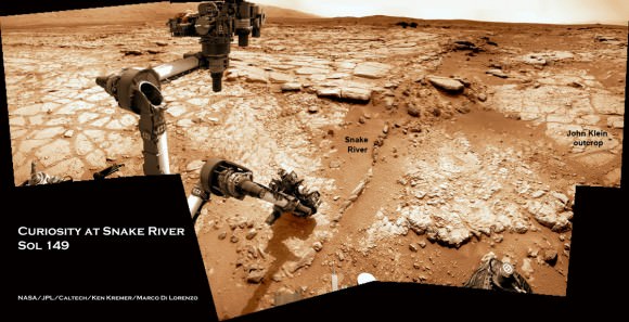
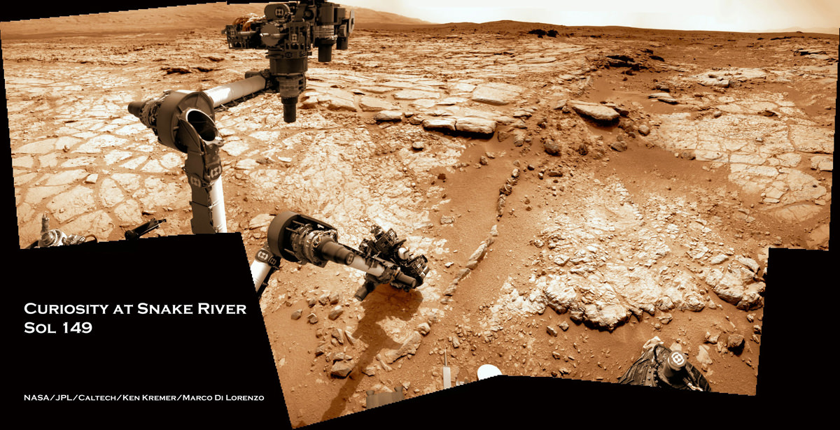
Image caption: Curiosity will carry out 1st rock drilling at ‘John Klein’ outcrop visible in this time lapse mosaic showing movements of Curiosity rover’s arm on Sol 149 (Jan. 5, 2013) at Yellowknife Bay basin where the rover has found widespread evidence for flowing water. Curiosity discovered hydrated mineral veins and concretions around the rock ledge ahead . She next drove there for contact science near the slithery chain of narrow protruding rocks known as ‘Snake River. Photomosaic stitched from Navcam raw images and colorized. Credit: NASA/JPL-Caltech/Ken Kremer/Marco Di Lorenzo

Rover Team Chooses 1st Rock Drilling Target for Curiosity

Image caption: Time lapse mosaic shows Curiosity rover’s arm movement from raised position to surface deployment on Sol 149 (Jan. 5) for contact science near the lower point of the slithery chain of narrow protruding rocks known as ‘Snake River’ – located inside the basin called “Yellowknife Bay’. The rover team will soon conduct historic first rock drilling in these surroindings. Curiosity has now driven to the larger, broken rock just above, right of the sinuous ‘Snake River’ rock formation. Photomosaic was stitched from Navcam raw images and is colorized with patches of sky added to fill in image gaps. Credit: NASA/JPL-Caltech/Ken Kremer/Marco Di Lorenzo

A team of Mars scientists and engineers have chosen the 1st rock drilling target for NASA’s Curiosity rover after carefully considering a range of options over the past several weeks at the robots current location inside a shallow depression known as ‘Yellowknife Bay’, which is replete with light toned rocks.

An official NASA announcement with further information is forthcoming on Tuesday this week, according to a source for this report.

Curiosity is now conducting a detailed science evaluation of the vicinity around a slithery chain of rocks called ‘Snake River’, jutting up from the sandy, rock strewn Martian floor – see our illustrative photo mosaics above & below and earlier story here.

Drilling goes to the heart of the mission and will mark a historic feat in planetary exploration – as the first time that an indigenous sample has been cored from the interior of a rock on another planet and subsequently analyzed by chemical spectrometers to determine its elemental composition and determine if organic molecules are present.

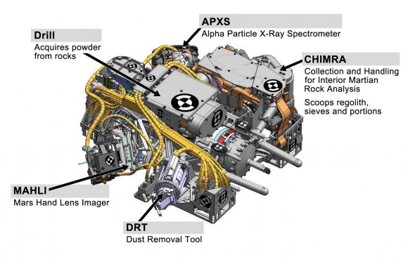
The first report of the drill target selection came just a day ago from Craig Covault at NASA Watch/Spaceref in an article, here – featuring our ‘Snake River’ time lapse mosaic (by Ken Kremer and Marco Di Lorenzo). The mosaic shows the arm in action deploying its science instruments and rotating to capture pictures with the MAHLI microscopic imager and contact science with the APXS mineral spectrometer.

The exact drilling spot has not been divulged but is likely near ‘Snake River’ and visible in our mosaics from Sol 149 and earlier Sols inside the ‘Yellowknife Bay’ basin – which exhibits cross bedding and is reminiscent of a dried up shoreline. Curiosity has now driven to the larger, broken rock just above, right of the sinuous ‘Snake River’ rock formation for up-close contact science investigations.

Curiosity 1st brushoff sol 150_1a_Ken Kremer

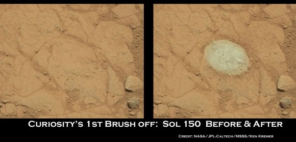
Image Caption: Before and after comparison of images of 1st ever rock brush off by Curiosity’s Dust Removal Tool (DRT) on Sol 150 (Jan 6, 2013), nearby to Snake River. Images taken by the high resolution Mastcam 100 camera, contrast enhanced. The brushed patch of rock target called “Ekwir_1” ‘is about 1.85 inches by 2.44 inches (47 millimeters by 62 millimeters). Credit: NASA/JPL-Caltech/MSSS/Ken Kremer

The Mars Science Lab (MSL) team is coordinating with top JPL & NASA management to get approval for the drilling location chosen or select another rock.

The high powered hammering drill is located on the tool turret at the end of the car-sized robots 7 foot (2.1 meter) long mechanical arm.

The percussive drill is the last component of Curiosity’s ten state-of-the-art science instruments that remains to be checked out and put into action.

Rock samples collected from the first test bore holes will be pulverized and the powdery mix will initially be used to rinse the interior chambers of the drill mechanisms and cleanse out residual earthly contaminants – and then dumped. The same procedure was carried out at the windblown ‘Rocknest’ ripple with the initial scoops of soil to cleanse the CHIMRA sample processing systems.

So it’s likely to take several weeks and possible a month or more until sieved samples are finally delivered to the CheMin and SAM analytical chemistry labs on the rover deck for analysis of their inorganic and organic chemical composition.

Curiosity touches Yellowknife Bay Sol 132_4c_Ken Kremer

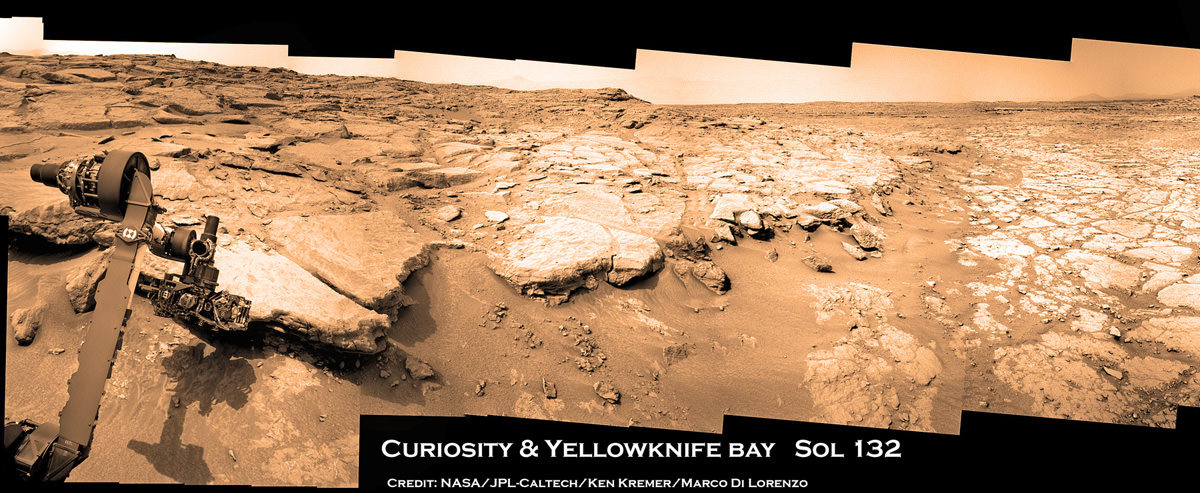
Image caption: Photo mosaic shows NASA’s Curiosity Mars rover reaching out to investigate rocks at a spot inside Yellowknife Bay on Sol 132, Dec 19, 2012. In search of first drilling target the rover drove to a spot at the right edge of this mosaic called Snake River rock. Curiosity’s navigation camera captured the scene surrounding the rover with the arm deployed and the APXS and MAHLI science instruments on tool turret collecting imaging and X-ray spectroscopic data. Base of Mount Sharp visible at right. The mosaic is colorized with patches of sky added to fill in gaps. Click to enlarge. Credit: NASA/JPL-Caltech/Ken Kremer/Marco Di Lorenzo

As a prelude on Sol 150 (Jan 6.), the rover successfully brushed off one of the flat rocks around Snake River for the first time by using the motorized, wire-bristle brush on the Dust Removal Tool (DRT), built by Honeybee Robotics of NYC.

The brushing was completed on a rock target called ‘Ekwir_1’ – see our mosaic showing a before and after comparison of rock surface images snapped by the Mastcam-100 high resolution color camera.

Brushing is a key step prior to rock drilling and allows the team to much more easily gain insight into the rocks composition with the science instruments compared to the obscured view of a dust blanketed rock. Spirit & Opportunity also have Honeybee Robotics built brushes that have still endured throughout their years’ long miraculous lifetimes.

The team then commanded the rover to bump a bit closer to “slightly younger rocks in front of the rover,” says MSL team member Ken Herkenhoff.

“The contact science activities in the current location went well, including the first brushing of the surface. In order to characterize the geology and chemistry of the rocks at the edge of Yellowknife Bay, we intend to repeat the set of brushing, APXS, MAHLI, ChemCam and Mastcam activities at the new location starting on Sol 152.”

“We are studying chemical and textural differences in the rocks near Snake River,” says Herkenhoff.

On Sol 152 (Jan. 8), Curiosity drove 2.5 meters closer to the area surrounding ‘Snake River’ and began snapping high resolution color imagery.

“It’s one piece of the puzzle,” says John Grotzinger, the mission’s chief scientist of the California Institute of Technology. “It has a crosscutting relationship to the surrounding rock and appears to have formed after the deposition of the layer that it transects.”

Grotzinger and the team are excited because Curiosity is a sort of time machine providing a glimpse into the Red Planets ancient history when the environment was warmer and wetter billions of years ago and much more conducive to the origin of life.

Ken Kremer

PIA16145

Image caption: Diagram shows all instruments on Tool turret on robotic arm. Credit: NASA

Curiosity Touches Mars at Yellowknife Bay and Drives to Snake River for Drilling

Image Caption: Photo mosaic shows NASA’s Curiosity Mars rover in action reaching out to investigate rocks at a location called Yellowknife Bay on Sol 132, Dec 19, 2012 in search of first drilling target. The view is reminiscent of a dried up shoreline. Curiosity’s navigation camera captured the scene surrounding the rover with the arm deployed and the APXS and MAHLI science instruments on tool turret collecting microscopic imaging and X-ray spectroscopic data. The mosaic is colorized. See the full 360 degree panoramic and black & white versions below. Credit: NASA/JPL-Caltech/Ken Kremer/Marco Di Lorenzo

Following the Christmas season break for panoramic imaging of her surroundings, NASA’s Curiosity robot has resumed roving around the shallow depression she reached before the holidays called ‘Yellowknife Bay’ and just arrived at a slithery rock called ‘Snake River’.

The top priority is to locate a target rock to drill into – and that momentous event could at last take place in the next week or so. The drill is the last of Curiosity’s suite of ten science instruments to be fully checked out and commissioned for use.

The drilling scene will look a lot like our photo mosaics, above and below, showing the robotic arm deployed for action. The drill is located on the tool turret at the end of the 7 foot (2.1 meter) long mechanical marvel.

The Curiosity research team is using the newly collected cache of high resolution color images to scan her surroundings in search of scientifically interesting rocks for the historic inaugural use of the high powered hammering drill.

Curiosity touches Yellowknife Bay Sol 132_4c_Ken Kremer

Image Caption: Photo mosaic shows NASA’s Curiosity Mars rover in action reaching out to investigate rocks at a location called Yellowknife Bay on Sol 132, Dec 19, 2012. In search of first drilling target the rover drove to a spot at the right edge of this mosaic called Snake River rock. Curiosity’s navigation camera captured the scene surrounding the rover with the arm deployed and the APXS and MAHLI science instruments on tool turret collecting imaging and X-ray spectroscopic data. Base of Mount Sharp visible at right.The mosaic is colorized with patches of sky added to fill in gaps. Click to enlarge. Credit: NASA/JPL-Caltech/Ken Kremer/Marco Di Lorenzo

The percussive drill will collect the first ever powdered samples from the interior of Martian rocks for analysis by a pair of state-of-the-art analytical chemistry instruments located inside the rover named SAM and CheMin.

“We are firing on all cylinders now and our last thing to do is drilling, and we really hope to start on that process beginning next week,” said John Grotzinger, the mission’s chief scientist of the California Institute of Technology, in an interview with Jonathan Amos of the BBC.

The rover is also using the APXS X-ray mineral spectrometer, ChemCam rock blasting laser and MAHLI hand lens imager to gather science characterization data helpful in choosing the drill target.

Today (Jan. 5) marks exactly 5 months since Curiosity’s hair-raisingly successfully touchdown on Aug. 5, 2012 on the gravelly plains of Gale Crater beside the towering foothills of Mount Sharp, a 3 mi (5 km) high layered mountain holding deposits of hydrated minerals. Mount Sharp is the main destination of Curiosity’s mission.

On Jan. 3 (Sol 147), Curiosity drove another 10 feet (3 meters) northwestward and pulled up to a sinuous rock feature called “Snake River” as part of a campaign to survey a variety of rocks from which to select the drilling site.

“It’s one piece of the puzzle,” says John Grotzinger. “It has a crosscutting relationship to the surrounding rock and appears to have formed after the deposition of the layer that it transects.”

717343main_pia16564-43_946-710

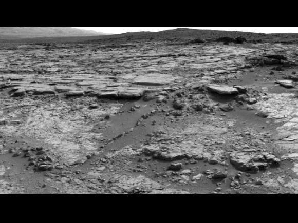
‘Snake River’ sinuous Rock Feature Viewed by Curiosity Mars Rover on Sol 133. On Sol 147 (Jan 3. 2013), the rover drove to within arm’s reach of Snake river for up close examination as possible drill target. Credit: NASA/JPL-Caltech

Snake River is a thin curving line of darker rock cutting through flatter rocks and jutting above sand, says NASA. It’s located at the right side edge of our Sol 132 photo mosaic stitched together from raw images by the image processing team of Ken Kremer & Marco Di Lorenzo to provide a context view of the scenery – and were also featured at NBC News by Alan Boyle, BBC News, NASA Watch and the NY Daily News.

So far the robot has driven a total of 2,303 feet (702 meters) and snapped nearly 36,000 pictures.

Yellowknife Bay is a basin inside an area dubbed ‘Glenelg’ that features a flatter and lighter-toned type of terrain from what the mission crossed during its first four months inside Gale Crater. The rover descended about 2 feet (0.5 m) down a slight incline to reach the inside of the depression in December 2012.

“We’re down at the very lowest layer – what would be the oldest layer that we would see in this succession that might be five to eight meters thick, and that is very likely where we are going to choose our first drilling target, because suddenly we’ve come into an area that represents a very high diversity of things we haven’t seen before,” said Grotzinger to the BBC.

“The place where Curiosity is right now is a small stack of layers – very impressive – and they could be 3-3.5 billion years old, and so we’re very excited about this because unlike the soil which we were analyzing before the holiday season – a loose, windswept patch of dirt on the surface of Mars – we’re now going to start digging down into the very ancient bedrock which we really built the rover to look at,” explained Grotzinger.

Curiosity & Yellowknife Bay Sol 125_2c_Ken Kremer

Image caption: Curiosity peaks around Yellowknife Bay on Sol 125, Dec 12, 2012. The rover has continued driving inside the basin in search of 1st rock drill target in Jan 2013. Credit: NASA/JPL-Caltech/Ken Kremer/Marco Di Lorenzo

The mission goal is to search for habitats and determine if Mars ever could have supported microbial life in the past or present during the 2 year primary mission phase.

“We use these layers as a sort of recording device of past events and conditions, and the rover has the same kind of analytical capability that we would use here on Earth to tell us about the early environmental conditions; and, if life had ever evolved, [whether it would] be the kind of environment that would have been conducive towards sustaining that life,” Grotzinger elaborated to the BBC.

Stay tuned.

Ken Kremer

Curiosity touches Yellowknife Bay Sol 132_3c_Ken Kremer

Image Caption: Photo mosaic shows NASA’s Curiosity Mars rover in action reaching out to investigate rocks at a location called Yellowknife Bay on Sol 132, Dec 19, 2012. Credit: NASA/JPL-Caltech/Ken Kremer/Marco Di Lorenzo

Curiosity Inspects ‘Shaler’ Outcrop on Descent to Yellowknife Bay Drill Target – 2D/3D

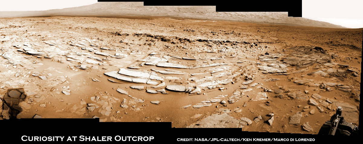
Image caption: Sol 120 colorized panorama of big and stunning ‘Shaler’ layered rock outcrop snapped by Curiosity’s right eye Navigation Camera (Navcam) on Dec. 7, 2012. ‘Shaler’ exhibits a pattern geologists refer to as ‘crossbedding’, at angles to one another. Some of the larger individual plates are about a foot or more wide. The cropped view spans from north at left to south at right. Future destination Mount Sharp is visible in the background. See the full 2-D panorama below and compare with the stereo effect available from NASA’s 3-D panorama, below. Credit: NASA/JPL-Caltech/Ken Kremer/Marco Di Lorenzo

NASA’s Curiosity rover is on the final steps of her descent into a geologist’s paradise at an area called ‘Yellowknife Bay’.

Along the way just days ago on Sol 120 (Dec 7, 2012) she stopped to inspect a huge outcrop of layered rocks dubbed ‘Shaler’ and snapped dozens of high resolution photos with the Navcam and Mastcam cameras.

To catch a human’s eye view of the breathtaking terrain of what some might hearken to an ‘unexpected journey’, check out our Sol 120 photo mosaic in 2-D (above) and then compare that with NASA’s 3-D photo mosaic (below). You will need to whip out you red-cyan anaglyph glasses to take in the full measure of Curiosity’s glorious surroundings and the foreboding shadow – can you guess what that is?

The ‘Shaler’ outcrop features a plethora of striking layers, angled to each other in a pattern geologists refer to as ‘crossbedding’.

The team also used Curiosity’s Chemistry and Camera (ChemCam) instrument on the rover’s mast to help assess the content of ‘Shaler.’

With the Christmas holidays fast approaching, the rover science team is searching for a suitable location at Yellowknife Bay to select as the first potential target to drill into with Curiosity’s advanced percussion drill.

Thereafter she will deliver powdered rock samples to the CheMin and SAM duo of miniaturized analytical chemistry labs on the rovers deck to elucidate the inorganic mineral composition as well as seek to determine if any organic molecules are present.

Image caption: Complete Sol 120 colorized panorama of big ‘Shaler’ layered rock outcrop snapped by Curiosity’s right eye Navigation Camera (Navcam) on Dec. 7, 2012. ‘Shaler’ exhibits a pattern geologists refer to as ‘crossbedding’, at angles to one another. The view spans from north-northwest at the left to south-southwest at the right. Study this full 2-D panorama and compare with the stereo effect available from NASA’s 3-D panorama, below. Credit: NASA/JPL-Caltech/Ken Kremer/Marco Di Lorenzo

Image caption: Sol 120 Stereo panorama of ‘Shaler’ rock outcrop snapped by the right and left eye Navigation Camera (Navcam) on Dec. 7, 2012. The view spans from north-northwest at the left to south-southwest at the right, and is presented in a cylindrical-perspective projection. Credit: NASA/JPL-Caltech

Yellowknife Bay lies within the place dubbed ‘Glenelg’, the rovers first major science destination. Glenelg uniquely sits at the junction of three different types of intersecting geologic features that will help unravel the mysteries of Curiosity’s Gale Crater touchdown zone beside a humongous mountain known as Mount Sharp – the main target of the mission.

After safely surviving the harrowing touchdown at ‘Bradbury Landing’ on Aug. 6, the SUV-sized Curiosity rover has been on a roll to reach the inviting interior terrain of ‘Glenelg’ before Christmas.

The six wheeled robot has thus far traversed more than 0.37 mile (598 meters) and is now driving on top of the most challenging and scientifically rewarding terrain of the entire four month journey.

“The rover is traversing across terrain different from where it has driven earlier, and responding differently,” said Rick Welch, mission manager at NASA’s Jet Propulsion Laboratory, Pasadena, Calif. “We’re making progress, though we’re still in the learning phase with this rover, going a little slower on this terrain than we might wish we could.”

Curiosity will spend at least several weeks thoroughly investigating Yellowknife Bay before reversing course and setting out on the year-long 6 mile (10 km) trek to the lower reaches of Mount Sharp. Along the way, the science team may possibly choose to re-investigate the Shaler and Hottah outcrops with the rover’s suite of 10 state-of-the-art science instruments.

Ken Kremer

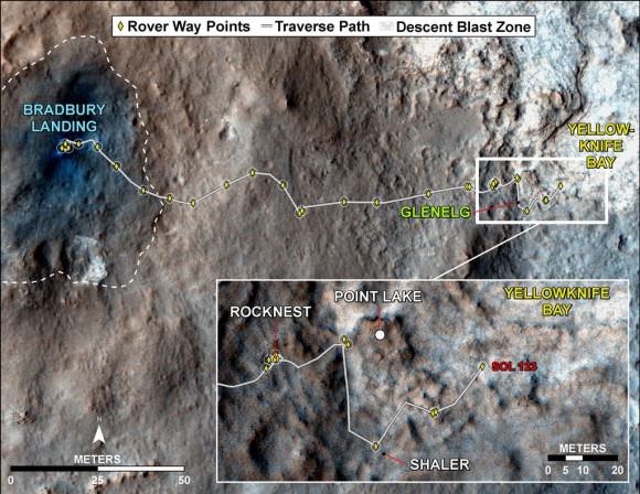
Image caption: Curiosity Traverse Map, Sol 123 (Dec. 10, 2012). This map traces where NASA’s Mars rover Curiosity drove between landing at a site named ‘Bradbury Landing,’ and the position reached during the mission’s 123rd Martian day, or sol, (Dec. 10, 2012) at ‘Yellowknife Bay’ inside the place called ‘Glenelg’. Credit: NASA/JPL-Caltech/Univ. of Arizona

Curiosity Gets a Sister – What Should She Do ? Scientists Speak

Mars Curiosity Sisters a1_Ken Kremer

Image caption: Seeing Double – Future Martian Sisters. NASA just announced plans to build and launch a new Mars science robotic rover in 2020 based on the design of the tremendously successful Curiosity rover which touched down safely inside Gale Crater on Aug. 6, 2012. This mosaic illustrates an imaginary Red Planet get-together of Curiosity and her yet to be constructed Martian sister. Credit: NASA/JPL-Caltech/MSSS/Ken Kremer

Curiosity will apparently get a sister after all and she’ll be born in 2020 – rising from the ashes of a near death experience.

The good news concerning approval of a future NASA Mars rover was announced this week by John Grunsfeld, NASA Associate Administrator for the Science Mission Directorate at NASA HQ, at the 2012 annual meeting of the AGU (American Geophysical Union) held in San Francisco.

What should Curiosity’s younger sister do? There are a multitude of great ideas, but a paucity of money in these very tough budget times – foremost among them is to gather and return the first ever Martian soil samples to Earth. What should the science goals be especially with regards to sample cache/return?

So, I asked these questions to Grunsfeld and leading Mars scientists, including Steve Squyres, Ray Arvidson and Jim Bell, the science team and camera leaders of NASA’s wildly successful Spirit and Opportunity Mars Exploration Rovers (MER). Opportunity is nearing the 9th anniversary of her Red Planet touchdown – and is exploring the most scientifically bountiful terrain yet of her entire mission at this very moment.

The design for the new Mars rover, let’s call it MSL 2, will be largely based on NASA’s hugely successful Curiosity Mars Science Laboratory (MSL) rover and the breathtaking rocket powered ‘Sky Crane’ landing architecture she so elegantly employed for touchdown barely 4 months ago on Aug. 6, 2012.

Grunsfeld and the researchers weighed in to Universe Today with their thoughts on this – “Will the 2020 Mars rover be focused on astrobiology and the search for life? Or, other goals like sample return or future human visits?”

“That question will ultimately be determined by the Science Definition Team,” Grunsfeld told me. “Historically the driving question behind our Mars exploration has been ‘are we alone in the universe?’ that includes searching for signs of conditions supportive of past and/or present life on Mars.”

Steve Squyres, of Cornell University in New York, says that “sample return is the next logical step” in Mars exploration.

“Simple… it should collect and cache a well-chosen set of samples for eventual return to Earth,” Squyres told me. “Doing so was the clear top priority of the recent planetary decadal survey.”

Squyres led the planetary decadel survey for the National Research Council (NRC) and is the scientific Principal Investigator for the Spirit and Opportunity MER rovers.

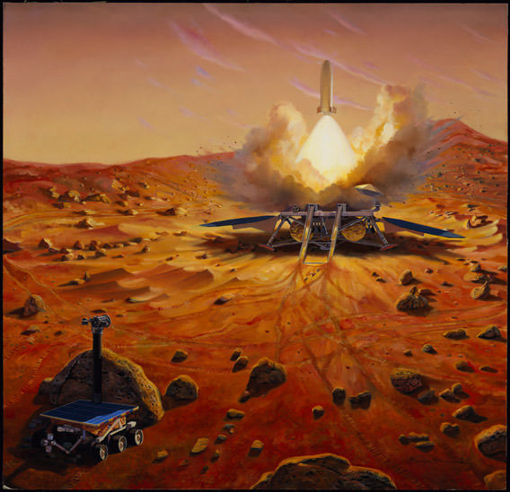
Image caption: Artists Concept for Mars Sample Return mission. Credit: NASA

“The recently announced 2020 rover has the potential to be directly responsive to the recommendations of the recent planetary decadal survey. The highest priority large mission identified by the Mars community, and indeed by the broader planetary community, in the decadal was a rover that would collect and cache a suite of samples for eventual return to Earth. The 2020 rover, which will be based on the highly capable MSL design, clearly can have that capability if it is appropriately equipped,” Squyres elaborated.

“The National Research Council planetary decadal survey documented the US planetary science community’s consensus views on future priorities for planetary exploration. The 2020 rover mission will be consistent with those priorities only if it collects and caches a suite of samples for eventual return to Earth,” Squyres told Universe Today.

Although retrieving and returning pristine samples from the Red Planet’s surface has long been the top priority for many researchers like Squyres, that ambitious goal would also be expensive and likely require a sequential series of flights to accomplish. But it is doable and would enable scientists on Earth to utilize every one of the most powerful science instruments at their disposal to help solve the most fundamental mysteries of all, like; ‘How did the Solar System form’, ’Did life ever exist on Mars’ and “Are We Alone?’

Ray Arvidson, of Washington University in St. Louis and deputy Principal Investigator for the MER rover, said this to Universe Today:

“For the 2020 rover I would frame the rationale and purpose as:

“*The surface area of Mars is equivalent to the surface area of Earth’s continents. The more we look the richer the geologic record relevant to ancient climatic conditions (e.g., the rover bed gravels found by MSL and the new clay hunting grounds Opportunity is exploring). Thus another MSL class rover and payload to a new site of paleo-environmental interest would be wonderful. Imagine trying to unravel Earth’s history by exploring three locations (MER+MSL) on the continents,” Arvidson informed me.

“*Given the rich, complex nature of the geologic record another MSL class rover exploring a new location will definitely help us narrow down the best place to go for sample return.”

“*For the 2020 rover include some engineering tests that will lead to a lower risk sample return mission. This could be what measurements to do to decide on which samples to acquire and keep, could be how to drill, handle, and cache, etc.”

Jim Bell, of Arizona State University and team leader for the MER Pancam cameras also feels that sample return is the top priority.

“I think it’s important that the 2020 rover adhere to the planetary science community’s stated goals for the next flagship-class mission to Mars–that it make significant progress towards a robotic Mars sample return’” Bell told me. “This was the judgment of the recent National Academy of Science’s Planetary Decadal Survey–representing the consensus of more than 1600 professional planetary scientists worldwide. The simplest way to implement that would be to make the 2020 rover a caching rover–able to store well-selected samples for potential later return to Earth by another mission.”

“I’m really excited about the opportunity to send a new MSL-class rover to Mars, and speaking with my Planetary Society President hat on, I think the public will be really excited to follow another mission as well.”

“Mars exploration is incredibly popular, and represents the best aspects of American engineering, innovation, and scientific exploration. That mission, and the continuing discoveries from Curiosity, Opportunity, and other missions, will help get us closer to answering age-old questions like, “are we alone?” Exciting!” Bell said.

By reutilizing the now proven MSL designs, NASA should be able to restrain and accurately estimate the development costs while simultaneously retiring a lot of the unknown risks associated with the construction and testing of MSL 1.

At the AGU briefing, Grunsfeld said that the 2020 rover will cost about $1.5 Billion, plus or minus $200 million, and fits within the president’s NASA budget request for 2013 and going forward. Curiosity cost about $2.5 Billion over the course of a 10 year development span.

“This mission concept fits within the current and projected Mars exploration budget, builds on the exciting discoveries of Curiosity, and takes advantage of a favorable launch opportunity,” says Grunsfeld.

The exact nature and actual mass of the 2020 rover’s science instruments will be decided by the Science Definition Team and also depends on the actual budget allocation received by NASA.

The surprising decision to fund MSL 2 comes despite the Obama Administrations cancellation earlier this year of NASA’s participation in a pair of missions to Mars, jointly proposed with the European Space Agency (ESA) – the 2016 Trace Gas Orbiter and the 2018 ExoMars rover. ESA has now forged a new alliance with Russia to carry out Mars exploration. NASA will fund instruments on both spacecraft.

In February 2012, the Obama Administration cut the planetary science budget by 20% and NASA was forced to withdrawn from the two joint Mars missions with ESA – as outlined earlier here and here.

So, I asked Grunsfeld, “Will the 2020 mission be international with participation by ESA or Roscosmos?”

“Yes, it will be international. Details will be worked out in the planning phase,” Grunsfeld replied.

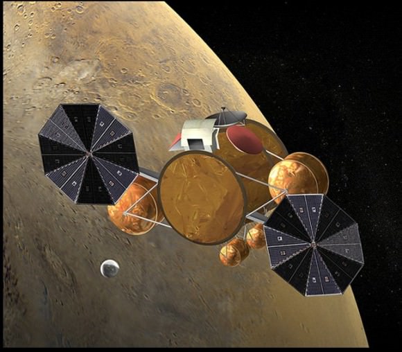
Image caption: Artist concept shows Earth return capsule with Red planet samples during rendezvous in Mars orbit. Credit: NASA

The 2020 launch window is next most favorable window after 2018 and would permit a higher weight of landed science instruments compared to Curiosity.

U.S. Rep. Adam Schiff (D-CA), who represents the area that is home to NASA’s Jet Propulsion Laboratory, and has worked to reverse the budget cuts, applauded the announcement of “the new robotic science rover set to launch in 2020.”

Schiff issued a statement that said, “While a 2020 launch would be favorable due to the alignment of Earth and Mars, a launch in 2018 would be even more advantageous as it would allow for an even greater payload to be launched to Mars. I will be working with NASA, the White House and my colleagues in Congress to see whether advancing the launch date is possible and what it would entail.”

Now it’s up to NASA to formulate a well defined and realistic plan that the politicians will support. The specific payload and science instruments for the 2020 mission will be openly competed following established processes for instrument selection. A science definition team will be appointed to outline the scientific objectives for the mission.

Stay tuned here for continuing updates on Curiosity and the future of Mars exploration and more.

** Here is your chance to do something positive & simple – and ‘Save Our Science’!

Cast your vote for Curiosity as TIME magazine Person of the Year. Vote now and avoid the long lines at the polling booth – before it’s too late. You only have until 11:59 p.m. on Dec. 12 to cast your vote online.

Ken Kremer

…..
Learn more about Curiosity’s groundbreaking discoveries and NASA missions at my upcoming free presentation for the general public at Princeton University.

Dec 11: Free Public lecture titled “Curiosity and the Search for Life on Mars (in 3 D)” and more including the Space Shuttle, Orion and SpaceX by Ken Kremer at Princeton University and the Amateur Astronomers Association of Princeton (AAAP) in Princeton, NJ at 8 PM – Princeton U campus at Peyton Hall, Astrophysics Dept. Students welcome.

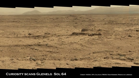
Image Caption: Panoramic mosaic shows gorgeous Glenelg terrain where Curiosity is now touring in search of first rocks to drill into and sample. The eroded rim of Gale crater and base of Mount Sharp seen in the distance. This is a cropped version of the wider mosaic as assembled from 75 images acquired by the Mastcam 100 camera on Sol 64 in October 2012. Credit: NASA/JPL-Caltech/MSSS/Ken Kremer/Marco Di Lorenzo

Vote ‘Curiosity’ as TIME Person of the Year

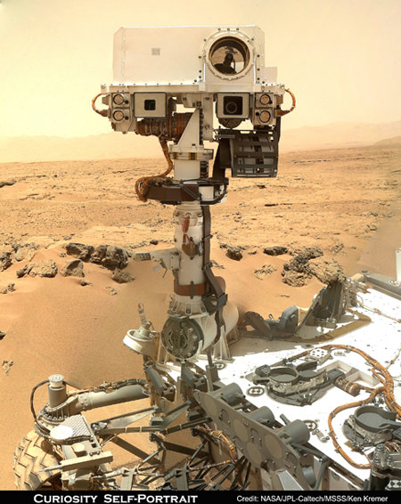
I Need You ! Vote for ‘Curiosity’ as TIME magazine Person Of The Year. NASA’s new Curiosity Mars rover snapped this Head and Shoulders Self-Portrait on Sol 85 (Nov. 1 , 2012) as Humanity’s emissary to the Red Planet in Search of Signs of Life. Mosaic Credit: NASA/JPL-Caltech/MSSS/Ken Kremer/Marco Di Lorenzo

Caption – I Need You ! Vote for ‘Curiosity’ as TIME magazine Person Of The Year.
NASA’s new Curiosity Mars rover snapped this Self-Portrait on Sol 85 (Nov. 1 , 2012) as Humanity’s emissary to the Red Planet in Search of Signs of Life. Mosaic Credit: NASA/JPL-Caltech/MSSS/Ken Kremer/Marco Di Lorenzo

You can make it happen. Vote Now ! Vote Curiosity !

Vote for ‘Curiosity’ as the Time magazine Person of the Year

Make your voice heard – Help send a message to the Feds to “Save Our Science” as the Fiscal Cliff nears and threatens our Science.

Perhaps you are a doubter. Well think again. Because at this moment NASA’s Curiosity Mars rover has thrust forward into 5th Place, inching ahead of – comedian Stephen Colbert, according to the running tally at TIME’s Person of the Year website.

NASA’s SUV-sized Curiosity Mars rover is the most powerful science robot ever dispatched as Humanity’s emissary to the surface of the Red Planet. She is searching for Signs of Life and may shed light on the ultimate questions – “Are We Alone?” – “Where do We fit In?

Curiosity is NASA’s first Astrobiology mission to Mars since the twin Viking landers of the 1970’s.

TIME’s editors are soliciting your input on worthy candidates for Person of the Year, although they will choose the ultimate winner.

You have until 11:59 p.m. on Dec. 12 to cast your vote. The winner of the people’s choice will be announced on Dec. 14. The magazine itself with the ultimate winner appears on newsstands on Dec. 21

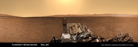
Image caption: Curiosity trundling across Mars surface inside Gale Crater on Sol 24 (Aug. 30, 2012). Colorized mosaic stitched together from Navcam images. This panorama is featured on PBS NOVA ‘Ultimate Mars Challenge’ documentary which premiered on PBS TV on Nov. 14. Credit: NASA / JPL-Caltech / Ken Kremer / Marco Di Lorenzo

Read TIME’s statement about voting for Curiosity:

You may own a cool car — you may even own a truly great car — but it’s a cinch that no matter how fantastic it is, it can never be anything more than the second best car in the solar system. The greatest of all is the Mars Curiosity rover, one ton of SUV-size machine now 160 million miles from Earth and trundling across the Martian surface. It was the rover’s landing on Mars last August that first caught people’s eyes: an improbable operation that required a hovering mother ship to lower the rover to the surface on cables like a $2.5 billion marionette. But it’s the two years of exploration Curiosity has ahead of it — with a suite of instruments 10 times as large as any ever carried to Mars before — that will make real news. NASA built the country one sweet ride, and yes, alas, it’s sweeter than yours.

Cast your vote for Curiosity now, and avoid the long lines – before it’s too late

Ken Kremer

…..

Learn more about Curiosity’s groundbreaking discoveries and NASA missions at my upcoming pair of free presentations for the general public at two colleges in New Jersey:

Dec 6: Free Public lecture titled “Atlantis, The Premature End of America’s Shuttle Program and What’s Beyond for NASA” including Curiosity, Orion, SpaceX and more by Ken Kremer at Brookdale Community College/Monmouth Museum and STAR Astronomy club in Lincroft, NJ at 8 PM

Dec 11: Free Public lecture titled “Curiosity and the Search for Life on Mars (in 3 D)” and more by Ken Kremer at Princeton University and the Amateur Astronomers Association of Princeton (AAAP) in Princeton, NJ at 8 PM – Princeton U Campus at Peyton Hall, Astrophysics Dept.