Scientist Explains the Weird Shiny Thing on Mars

A zoomed-in view of the shiny protuberance. Credit: NASA/JPL-Caltech/Malin Space Science Systems. Image via 2di7 & titanio44 on Flickr.

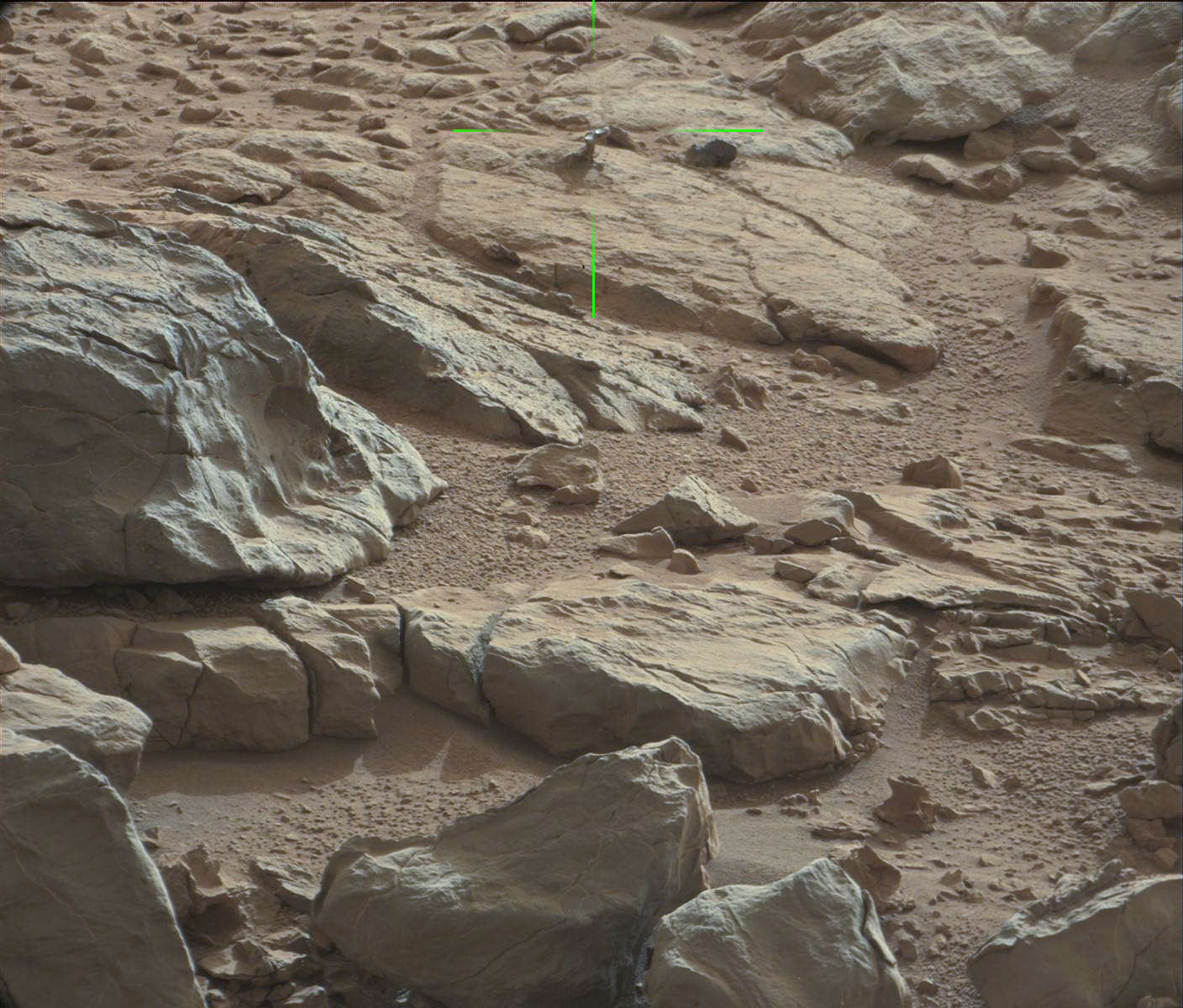
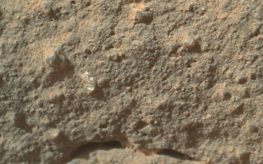
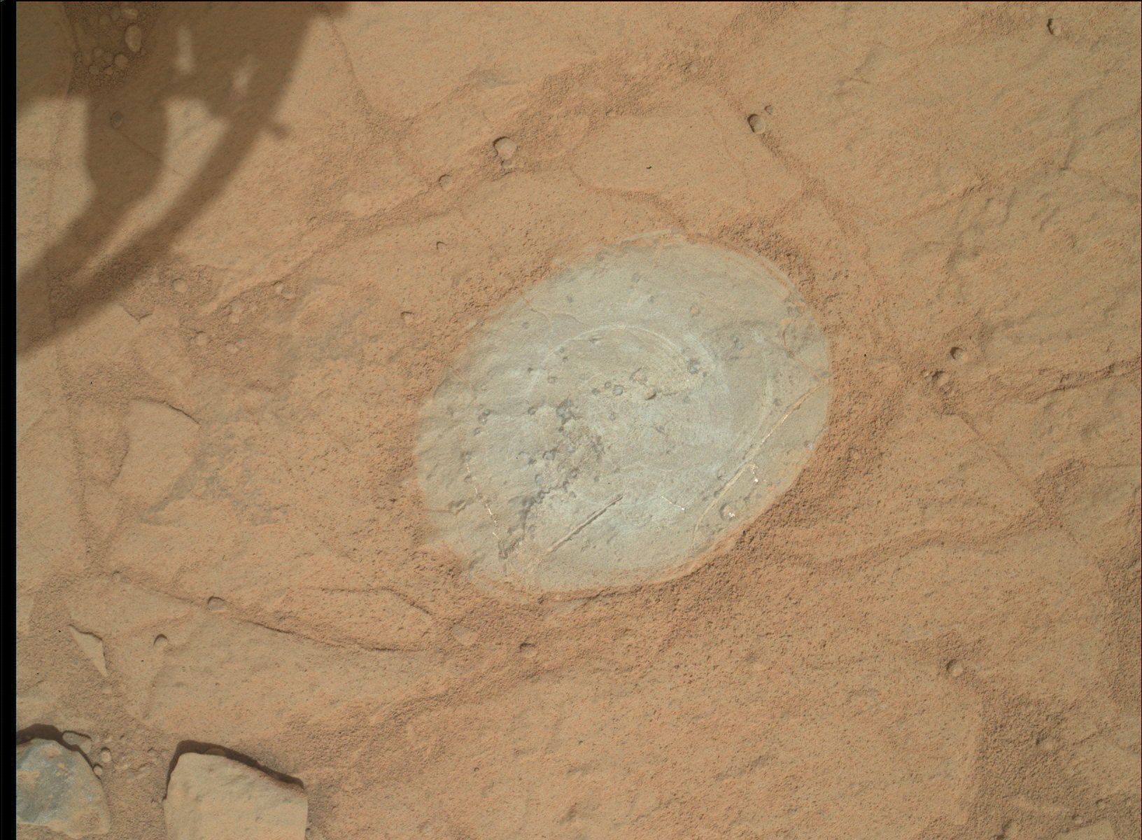
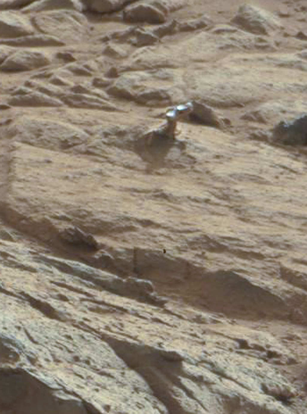
As we reported last week, images from the Curiosity rover showed what looked like a piece of shiny metal sticking out from a rock. Some of our readers suggested that it might be a handle or knob of some kind. It’s a knob, yes, says Ronald Sletten from the Mars Science Laboratory team, but a completely natural formation. Sletten, from the University of Washington, explained that, not surprisingly, it is actually a part of the rock that is different — harder and more resistant to erosion — than the rest of the rock it’s embedded in.

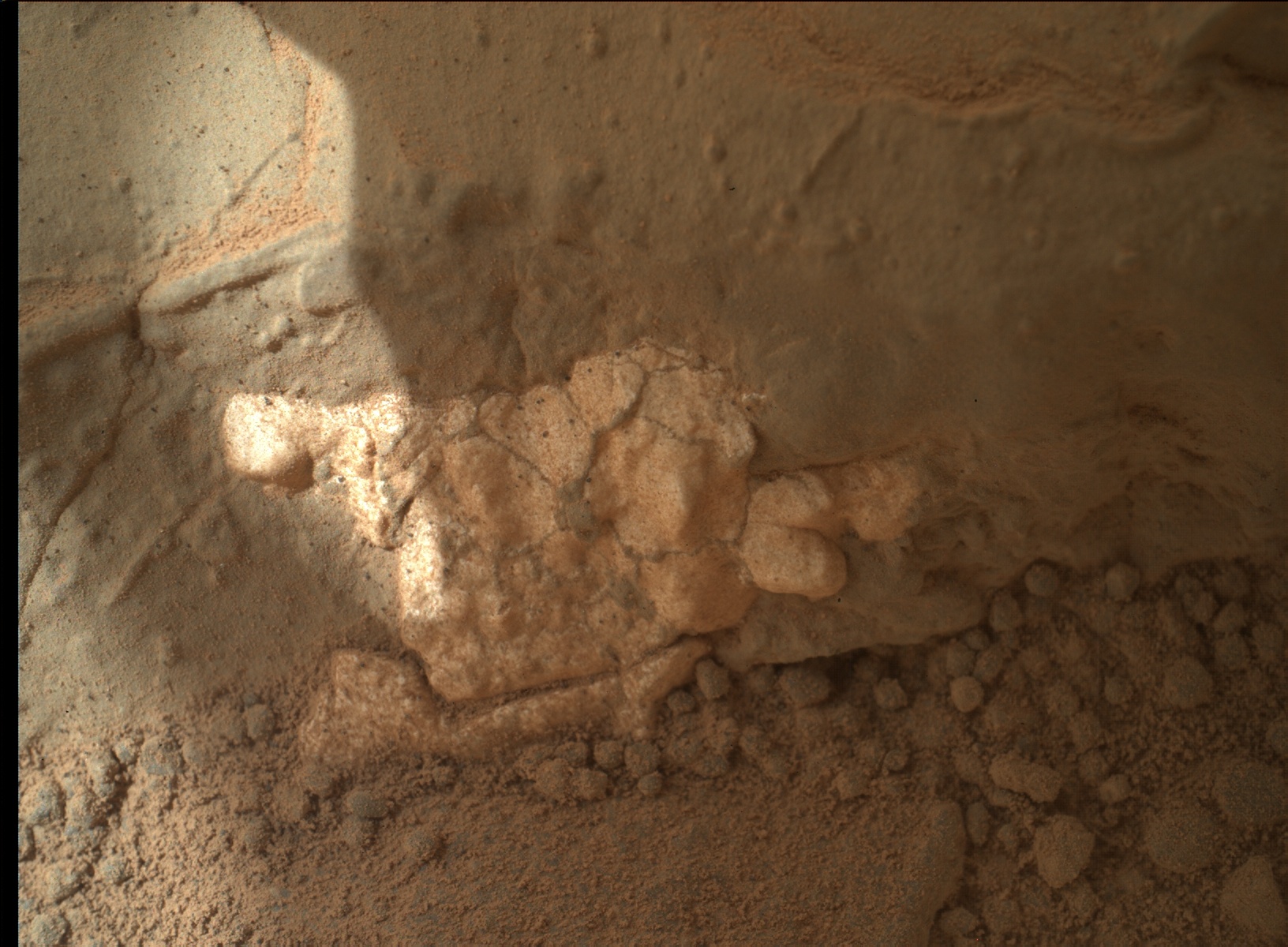
On Earth, as on Mars, “often you can see knobs or projections on surfaces eroded by the wind, particularly when a harder, less erodible rock is on top,” Sletten said, via an email to Universe Today from the Jet Propulsion Laboratory media relations office. “The rock on top of the projection is likely more resistant to wind erosion and protects the underlying rock from being eroded.”

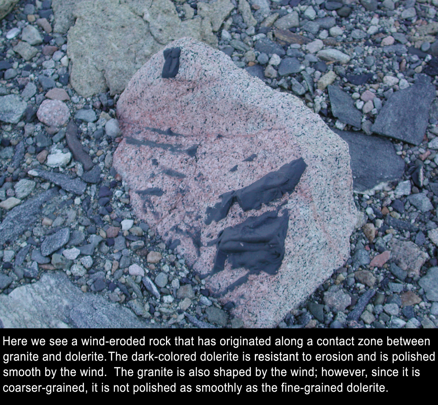
As far as why it appears shiny, Sletten said, “The shiny surface suggests that this rock has a fine grain and is relatively hard. Hard, fine grained rocks can be polished by the wind to form very smooth surfaces.”

It also may be shiny because it is wind-blasted and therefore dust-free, Sletten said, “while the surfaces not directly being eroded by wind may have a fine layer of reddish dust or rock-weathering rind. The sandblasted surfaces may reveal the inherent rock color and texture.”

He added that the object is an interesting study in how wind and the natural elements cause erosion and other effects on various types of rocks.

A closeup of the shiny protuberance. Credit: NASA/JPL/Malin Space Science Systems.

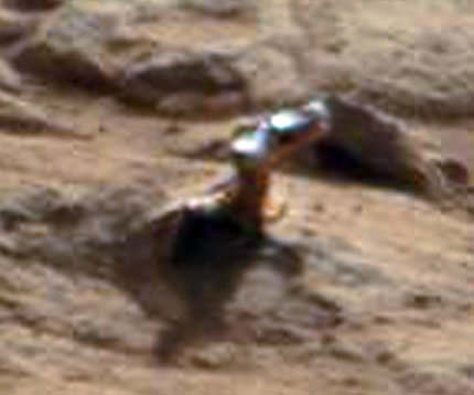
In looking at a zoomed-in close-up of the “knob” or protuberance from the rock, Sletten said, “This knob has a different type of rock on the end of the projection. This rock may vary in composition or the rock grain size may be smaller.”

A shiny-looking Martian rock is visible in this image taken by NASA's Mars rover Curiosity's Mast Camera (Mastcam) during the mission's 173rd Martian day, or sol (Jan. 30, 2013). Image Credit: NASA/JPL-Caltech/Malin Space Science Systems.
A shiny-looking Martian rock is visible in this image taken by NASA’s Mars rover Curiosity’s Mast Camera (Mastcam) during the mission’s 173rd Martian day, or sol (Jan. 30, 2013). Image Credit: NASA/JPL-Caltech/Malin Space Science Systems.

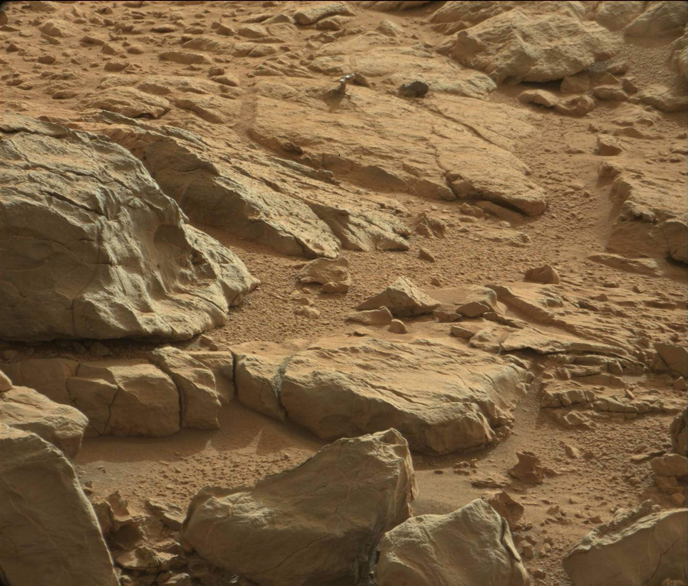
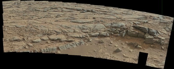
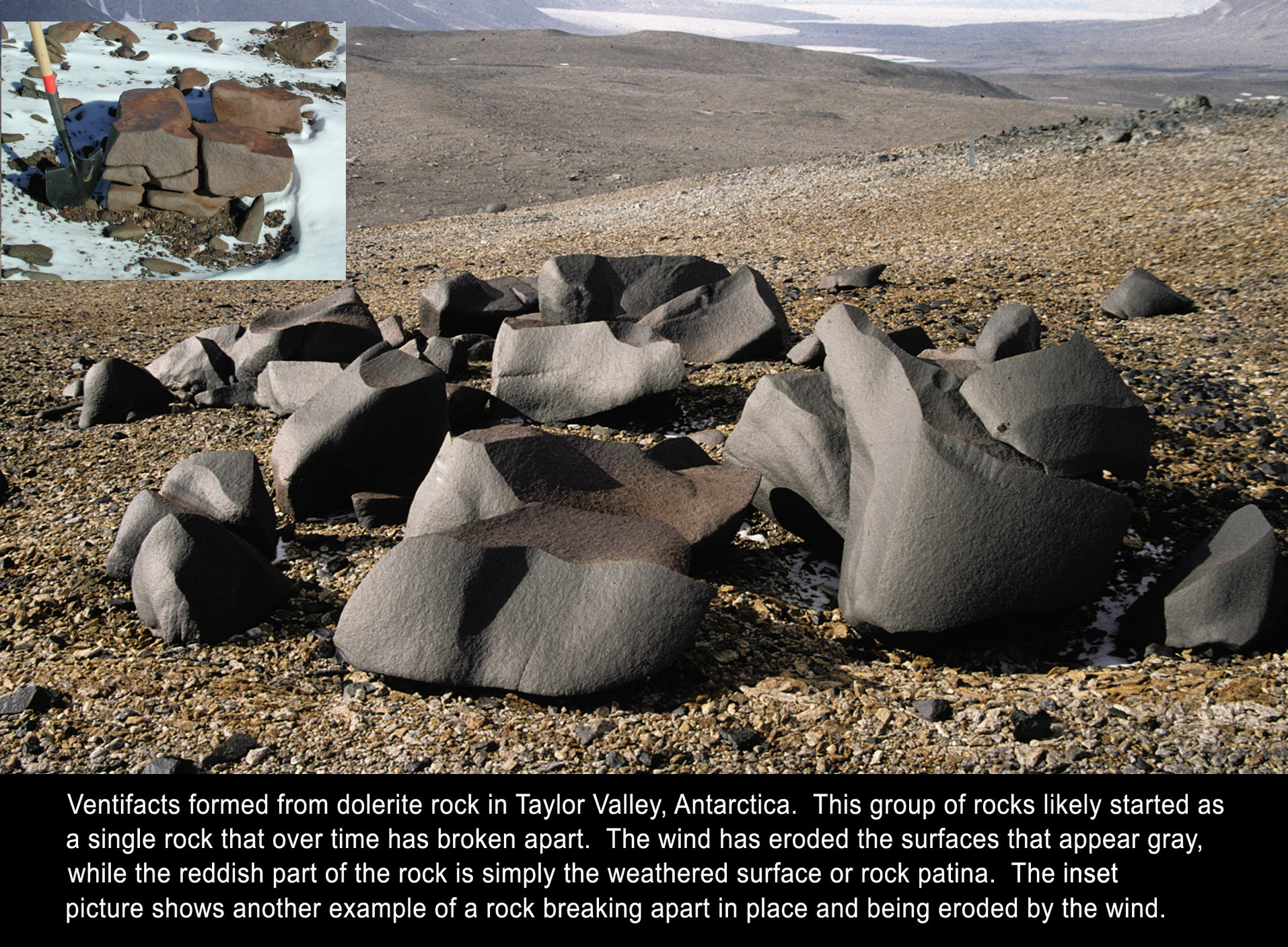
Because of the winds on Mars, there is quite a bit of erosion of rock, visible in the image above, as well as in many images from all the Mars rovers and landers. These type of surfaces are called “ventifacted” — wind-eroded surfaces caused by many fine particles of dust or sand impacting the surface over time. Areas of rocks may appear sculpted, as softer parts erode more easily or they may reflect small scale wind patterns, Sletten said.

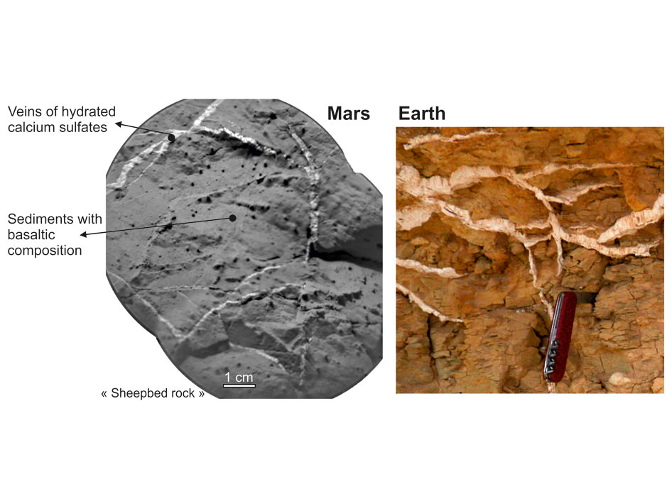
In some ways, he added, it’s a lot like what happens to rocks in Antarctica. See the annotated images he provided below:

Annotated image supplied by Ronald Sletten, MSL science team.

So, this weird shiny thing on Mars is nothing too out of the ordinary — not a door handle, hood ornament or not even Richard Hoagland’s bicycle, as was suggested by readers on our previous article.

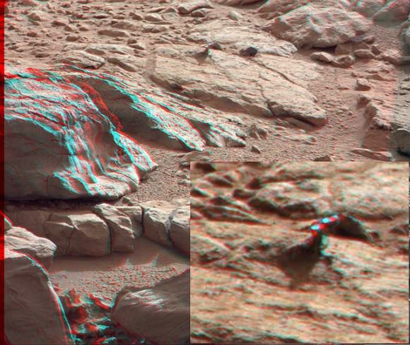
But for one more look, here’s the 3-D version(make sure you use the red-green 3-D glasses):

3-D anaglyph from the right and left Mastcam from Curiosity showing the metal-looking protuberance. Credit: NASA/JPL/Caltech/Malin Space Science Systems. Anaglyph by by 2di7 & titanio44 on Flickr.

The original raw image from the Curiosity rover can be seen here, and our thanks to Elisabetta Bonora, an image editing enthusiast from Italy, who originally pointed this image out to us.

Another Weird Shiny Thing on Mars

Green lines point to a shiny protuberance on rock imaged by the Curiosity rover on Mars. Credit: NASA/JPL-California Institute of Tecnology. Image processing 2di7 & titanio44 on Flickr.

The Curiosity Mars rover has found some strange-looking little things on Mars – you’ve likely heard of the Mars ‘flower,’ the piece of benign plastic from the rover itself, and other bright flecks of granules in the Martian soil. Now the rover has imaged a small metallic-looking protuberance on a rock. Visible in the image above (the green lines point to it), the protuberance appears to have a high albedo and even projects a shadow on the rock below. The image was taken with the right Mastcam on Curiosity on Sol 173 — January 30, 2013 here on Earth — (see the original raw image here), and was pointed out to us by Elisabetta Bonora, an image editing enthusiast from Italy.

“The corresponding image from the left Mastcam is not there,” said Bonora via email, “which is a real shame because this would allow us to make an anaglyph.”

UPDATE: Since yesterday when we posted this, the left Mastcam image is now available, and so Bonora has put a 3-D view of this little metal-looking thingy. After seeing this anaglyph, it is even more perplexing! Make sure you view it with the red/green 3-D glasses:

See below:

3-D anaglyph from the right and left Mastcam from Curiosity showing the metal-looking protuberance. Credit: NASA/JPL/Caltech/Malin Space Science Systems. Anaglyph by
3-D anaglyph from the right and left Mastcam from Curiosity showing the metal-looking protuberance. Credit: NASA/JPL/Caltech/Malin Space Science Systems. Anaglyph by 2di7 & titanio44 on Flickr.

As Bonora pointed out, the protuberance seems different than the rock on which it sits – it could be composed of material more resistant to erosion than the rest and similar material could be within the rock, or it could be something that is “grown” on the rock.
However, it looks fairly smooth, and in fact it is not covered by dust as is the case for metal surfaces that tend to clean easily.

But “small” is the operative word here, as the little protuberance is probably about 0.5 cm tall, or even smaller 3 centimeters tall, according to the image editing specialists at UnmannedSpaceflight.com.

A closeup of the shiny protuberance. Credit: NASA/JPL/Malin Space Science Systems. Image editing by  2di7 & titanio44 on Flickr.
A closeup of the shiny protuberance. Credit: NASA/JPL/Caltech/Malin Space Science Systems. Image editing by 2di7 & titanio44 on Flickr.
Another zoomed-in view of the shiny protuberance. Credit: NASA/JPL-Caltech/Malin Space Science Systems. Image via 2di7 & titanio44 on Flickr.

Here’s a full panorama of the area:

Panorama of the area, from Sol 173. Credit: NASA/JPL/Caltech/Malin Space Science Systems. Image editing by
Panorama of the area, from Sol 173. Credit: NASA/JPL/Caltech/Malin Space Science Systems. Image editing by 2di7 & titanio44 on Flickr.

Whatever it is, the weird little shiny thing is interesting, and we hope to have more details about it soon from one of the rover scientists.

See all the raw rover images on the MSL website, and more images on Bonora’s Flickr page.

MSL Update: Curiosity Finds Calcium-Rich Deposits

Veins in Rocks on Mars and Earth. Ccredit: NASA/JPL-Caltech/LANL/CNES/IRAP/LPGNantes/CNRS/LGLyon/Planet-Terre

Justin Maki, the Engineering Camera Team Lead for the Mars Science Laboratory provides the latest Curiosity Rover Report from JPL and talks about how the rover has found calcium deposits on Mars similar to those seen on Earth when water circulates in cracks and rock fractures.

The set of images below shows the similarity of sulfate-rich veins seen on Curiosity rover to sulfate-rich veins seen on Earth. The view on the left is a mosaic of two shots from the remote micro-imager on Curiosity’s Chemistry and Camera (ChemCam) instrument on Dec. 14, 2012, or the 126th sol, or Martian day, of operations. They show a view of “Sheepbed” rock in the “Yellowknife Bay” area of Mars. The sulfate-rich veins are the light-colored veins about 1 to 5 millimeters (0.04 to 0.2 inches) wide.

The image on the right is from the Egyptian desert on Earth. A pocket knife is shown for scale. (image courtesy of Pierre Thomas).

Curiosity’s Rambling Tracks Visible from Mars Orbit

Tracks from the Curiosity rover were imaged by the HiRISE camera on the Mars Reconnaissance Orbiter on January 2, 2012. Credit: NASA/JPL/University of Arizona.

Look closely and see where the Curiosity rover has been roving about inside Gale Crater on Mars, from “Bradbury Landing” to its current location in “Yellowknife Bay.” This shot was taken by the HiRISE camera on board the Mars Reconnaissance Orbiter on January 2, 2013.

“This image shows the entire distance traveled from the landing site (dark smudge at left) to its location as of 2 January 2013 (the rover is bright feature at right),” wrote HiRISE principal investigator Alfred McEwen on the HiRISE website. “The tracks are not seen where the rover has recently driven over the lighter-toned surface, which may be more indurated [hardened] than the darker soil.”

You can compare this image to one taken on September 8, 2012 to see how much the rover has driven in Gale Crater:

Curiosity rover tracks seen from orbit by HiRISE on September 8, 2012. Credit: NASA/JPL/University of Arizona.

And here’s a map of Curiosity’s travels that NASA released yesterday:

This image maps the traverse of NASA's Mars rover Curiosity from "Bradbury Landing" to "Yellowknife Bay," with an inset documenting a change in the ground's thermal properties with arrival at a different type of terrain. Image credit: NASA/JPL-Caltech/Univ. of Arizona/CAB(CSIC-INTA)/FMI.

Mission scientists said at a briefing yesterday (January 15, 2013) that between Sol (Martian day) 120 and Sol 121 of the mission — which equates to Dec. 7 and Dec. 8, 2012 — Curiosity crossed over a terrain boundary into lighter-toned rocks that correspond to high thermal inertia values observed by NASA’s Mars Odyssey orbiter. The green dashed line marks the boundary between the terrain types.

The inset graphs the range in ground temperature recorded each day by the Rover Environmental Monitoring Station (REMS) on Curiosity. Note that the arrival onto the lighter-toned terrain corresponds with an abrupt shift in the range of daily ground temperatures to a consistently smaller spread in values. This independently signals the same transition seen from orbit, and marks the arrival at well-exposed, stratified bedrock.

Sol 124 (Dec. 11, 2012) marked the arrival into an area called “Yellowknife Bay,” where sulfate-filled veins and concretions were discovered, along with much finer-grained sediments providing evidence of past water interacting with the surface.

Here’s the Mars weather report provided by REMS for Sol 158 (January 15, 2013):

Daily Weather Report
Image credit: NASA/JPL-Caltech.
Daily Weather Report. Image credit: NASA/JPL-Caltech.

A video showing the new HiRISE image of Curiosity’s tracks:

About That ‘Flower’ on Mars….

A bright and interestingly shaped tiny pebble shows up among the soil on a rock, called "Gillespie Lake," which was imaged by Curiosity's Mars Hand Lens Imager on Dec. 19, 2012, the 132nd sol, or Martian day of Curiosity's mission on Mars. Credit: NASA / JPL-Caltech / MSSS.

The Curiosity rover is having a “field day” exploring the rocks in a shallow depression that scientists call ‘Yellowknife Bay,’ which is chock-full of light toned rocks. One small rock or feature – the size of a pebble or large grain of sand, actually – has caught the attention of many as it looks like a little flower. Keep in mind that this pebble is about 2 millimeters in size (a US dime coin is 1.35mm thick) so that’s really teeny tiny. But through the power of zooming in to the high resolution images of the Mars Hand Lens Imager, or MAHLI, there have been people who are convinced this is some sort of flora on Mars, or perhaps a fossil.

Initially, it was suggested that this could perhaps be a piece of plastic from the rover, similar to what was found earlier, but the MSL scientists quickly determined this was actually part of the rock.

Today, deputy principal investigator of MAHLI, Aileen Yingst of the Planetary Science Institute, told reporters that the big rock of which the flower is a part, named ‘Gillespie Lake,’ is a relatively dust free, coarse grained sandstone, with several larger grains in the matrix, “which are interesting because of their color, luster and shape,” she said, and this unusually shaped grain is lighter in color – almost opaque — which indicates it could be made of something different than the rest of the rock.

What is it?

“It could be a lot of things, but without some chemical information to back me up, I’d really hesitate to say what it is,” said Yingst. “I’m not trying to be cagey, I’m just trying to be clear that a light grain could be a lot of different things.”

But what really matters is what the team is finding out about this region, as those rounded grains provide a clue to the history of this area.

“They’ve been knocked around, they’ve been busted up,” said Yingst. “They’ve been rounded by some process.

This suggests that flowing water helped form this rock.

Yingst also stressed that this feature is not biological, “But it does indicate that you have a relatively diverse set of grains just in this one sample,” she said.

So, water in the past but no flowers on Mars.

The rover has also found water-deposited mineral veins that fill fissures in the rocks, such as in the image below.

The team will continue to study this area, and have chosen a rock on which to use the rover’s drill for the first time.

Light-toned veins in the rocks in Yellowknife Bay. Credit: NASA/JPL/Malin Space Science Systems.

See more images from today’s briefing here.

Curiosity Rover Update: The Old Brush Off

This image from the Mars Hand Lens Imager (MAHLI) on NASA's Mars rover Curiosity shows the patch of rock cleaned by the first use of the rover's Dust Removal Tool (DRT). Image Credit: NASA/JPL-Caltech/MSSS

Justin Lin from the Mars Science Laboratory team gives the latest video update from the Curiosity rover mission. For the first time the rover used its Dust Removal Tool, and the team is looking for a good rock to perform the first use of the drill.

You can see some of the panoramas that Lin talks about in our previous article, “Curiosity Touches Mars at Yellowknife Bay and Drives to Snake River for Drilling.

Curiosity Tidies Up a Bit on Mars

This image from the Mars Hand Lens Imager (MAHLI) on NASA's Mars rover Curiosity shows the patch of rock cleaned by the first use of the rover's Dust Removal Tool (DRT). Image Credit: NASA/JPL-Caltech/MSSS

It’s a bit dusty on Mars, and so the Curiosity rover has now cleaned up a little spot. For the first time ever, the newest Mars rover has used its Dust Removal Tool.

“The underlying rock and the windblown dust on top of it are made of different material,” the @Mars_Curiosity Twitter feed explained. “Analysis to come.”

It will be interesting to find out what the dark circular features are in the rock. The target areas that was cleaned is named “Ekwir_1,” and it is on a rock in the “Yellowknife Bay” area of Mars’ Gale Crater. The rover team is also evaluating rocks in that area as potential targets for first use of the rover’s hammering drill in coming weeks.

The Dust Removal Tool is a motorized, wire-bristle brush designed to prepare selected rock surfaces for enhanced inspection by the rover’s science instruments. It is built into the turret at the end of the rover’s arm, visible in the image below.

Camera and brushes on Curiosity's Arm as Seen by Camera on Mast. Image credit: NASA/JPL-Caltech/MSSS

The science team said that choosing an appropriate target was crucial for the first-time use of the Dust Removal Tool.

“We wanted to be sure we had an optimal target for the first use,” said Diana Trujillo of NASA’s Jet Propulsion Laboratory, Pasadena, Calif., the mission’s activity lead for the Dust Removal Tool. “We need to place the instrument within less than half an inch of the target without putting the hardware at risk. We needed a flat target, one that wasn’t rough, one that was covered with dust. The results certainly look good.”

The Dust Removal Tool was built by Honeybee Robotics, which also built the Rock Abrasion Tool for the Spirit and Opportunity rovers.

Larger images and more info about the brushed area on Ekwir are online here and here.

Source: JPL

Curiosity Rover Report: At Grandma’s House

MSL team member Colette Lohr, the Tactical Uplink Lead, provides the latest video update on the Curiosity rover. The rover is at a location fittingly dubbed “Grandma’s House” during the holidays, and there should be many more adventures during 2013.

Curiosity Scans ‘Yellowknife Bay’ on Sol 130. NASA’s Curiosity rover celebrated her 1st Christmas on the Red Planet at ‘Yellowknife Bay’ and is searching for her 1st rock target to drill into for a sample to analyze. She snapped this panoramic view on Dec. 17 which was stitched together from navigation camera (Navcam) images. Credit: NASA/JPL-Caltech/Ken Kremer/Marco Di Lorenzo

Curiosity Inspects ‘Shaler’ Outcrop on Descent to Yellowknife Bay Drill Target – 2D/3D

Image caption: Sol 120 colorized panorama of big and stunning ‘Shaler’ layered rock outcrop snapped by Curiosity’s right eye Navigation Camera (Navcam) on Dec. 7, 2012. ‘Shaler’ exhibits a pattern geologists refer to as ‘crossbedding’, at angles to one another. Some of the larger individual plates are about a foot or more wide. The cropped view spans from north at left to south at right. Future destination Mount Sharp is visible in the background. See the full 2-D panorama below and compare with the stereo effect available from NASA’s 3-D panorama, below. Credit: NASA/JPL-Caltech/Ken Kremer/Marco Di Lorenzo

NASA’s Curiosity rover is on the final steps of her descent into a geologist’s paradise at an area called ‘Yellowknife Bay’.

Along the way just days ago on Sol 120 (Dec 7, 2012) she stopped to inspect a huge outcrop of layered rocks dubbed ‘Shaler’ and snapped dozens of high resolution photos with the Navcam and Mastcam cameras.

To catch a human’s eye view of the breathtaking terrain of what some might hearken to an ‘unexpected journey’, check out our Sol 120 photo mosaic in 2-D (above) and then compare that with NASA’s 3-D photo mosaic (below). You will need to whip out you red-cyan anaglyph glasses to take in the full measure of Curiosity’s glorious surroundings and the foreboding shadow – can you guess what that is?

The ‘Shaler’ outcrop features a plethora of striking layers, angled to each other in a pattern geologists refer to as ‘crossbedding’.

The team also used Curiosity’s Chemistry and Camera (ChemCam) instrument on the rover’s mast to help assess the content of ‘Shaler.’

With the Christmas holidays fast approaching, the rover science team is searching for a suitable location at Yellowknife Bay to select as the first potential target to drill into with Curiosity’s advanced percussion drill.

Thereafter she will deliver powdered rock samples to the CheMin and SAM duo of miniaturized analytical chemistry labs on the rovers deck to elucidate the inorganic mineral composition as well as seek to determine if any organic molecules are present.

Image caption: Complete Sol 120 colorized panorama of big ‘Shaler’ layered rock outcrop snapped by Curiosity’s right eye Navigation Camera (Navcam) on Dec. 7, 2012. ‘Shaler’ exhibits a pattern geologists refer to as ‘crossbedding’, at angles to one another. The view spans from north-northwest at the left to south-southwest at the right. Study this full 2-D panorama and compare with the stereo effect available from NASA’s 3-D panorama, below. Credit: NASA/JPL-Caltech/Ken Kremer/Marco Di Lorenzo

Image caption: Sol 120 Stereo panorama of ‘Shaler’ rock outcrop snapped by the right and left eye Navigation Camera (Navcam) on Dec. 7, 2012. The view spans from north-northwest at the left to south-southwest at the right, and is presented in a cylindrical-perspective projection. Credit: NASA/JPL-Caltech

Yellowknife Bay lies within the place dubbed ‘Glenelg’, the rovers first major science destination. Glenelg uniquely sits at the junction of three different types of intersecting geologic features that will help unravel the mysteries of Curiosity’s Gale Crater touchdown zone beside a humongous mountain known as Mount Sharp – the main target of the mission.

After safely surviving the harrowing touchdown at ‘Bradbury Landing’ on Aug. 6, the SUV-sized Curiosity rover has been on a roll to reach the inviting interior terrain of ‘Glenelg’ before Christmas.

The six wheeled robot has thus far traversed more than 0.37 mile (598 meters) and is now driving on top of the most challenging and scientifically rewarding terrain of the entire four month journey.

“The rover is traversing across terrain different from where it has driven earlier, and responding differently,” said Rick Welch, mission manager at NASA’s Jet Propulsion Laboratory, Pasadena, Calif. “We’re making progress, though we’re still in the learning phase with this rover, going a little slower on this terrain than we might wish we could.”

Curiosity will spend at least several weeks thoroughly investigating Yellowknife Bay before reversing course and setting out on the year-long 6 mile (10 km) trek to the lower reaches of Mount Sharp. Along the way, the science team may possibly choose to re-investigate the Shaler and Hottah outcrops with the rover’s suite of 10 state-of-the-art science instruments.

Ken Kremer

Image caption: Curiosity Traverse Map, Sol 123 (Dec. 10, 2012). This map traces where NASA’s Mars rover Curiosity drove between landing at a site named ‘Bradbury Landing,’ and the position reached during the mission’s 123rd Martian day, or sol, (Dec. 10, 2012) at ‘Yellowknife Bay’ inside the place called ‘Glenelg’. Credit: NASA/JPL-Caltech/Univ. of Arizona

Curiosity Update: Wrapping Up Rocknest

Here’s the latest video update from the MSL science team on Curiosity’s activities. It really just wraps up and recaps our article from earlier this week — that all of Curiosity’s science instruments are now fully up and running, that they found materials on Mars that have been seen by other missions, and they are still looking at some interesting carbon compounds. Also, Ashwin Vasavada reiterates what the science team said on Monday at the press conference: They’re doing science at the speed of science, and no one image or data point will cause us to re-write our science books.

Overhead map of Curiosity’s traverses. Credit: NASA/JPL/University of Arizona

As for what the rover will do next, a couple team members Tweeted today that the rover’s wake up song today was “Should I Stay or Should I Go.” Curiosity is now finishing up at observations at an area called Point Lake; they’ll do some surveys of they another area called Yellowknife Bay, and in the next couple of weeks, do some drive-by imaging, perhaps use ChemCam, and the team said they would really like to find a target for the first use of Curiosity’s drill before the holidays start here on Earth.