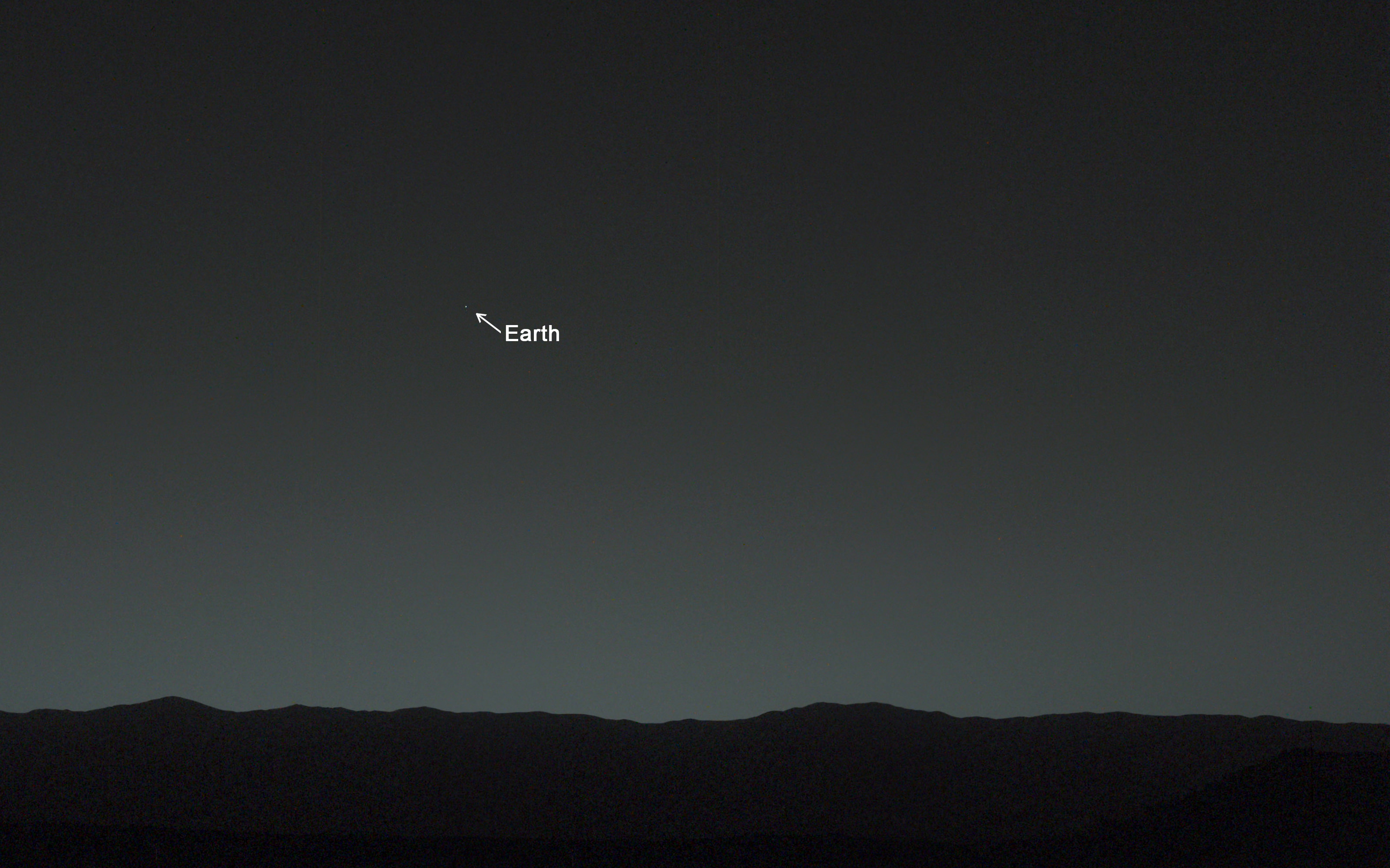
You are here! As an Evening Star in the Martian Sky. This evening-sky view taken by NASA's Mars rover Curiosity shows the Earth and Earth's moon as seen on Jan. 31, 2014, or Sol 529 shortly after sunset at the Dingo Gap inside Gale Crater. Credit: NASA/JPL-Caltech/MSSS/TAMU
You are here! – As an Evening Star in the Martian Sky
This evening-sky view taken by NASA’s Mars rover Curiosity shows the Earth and Earth’s moon as seen on Jan. 31, 2014, or Sol 529 shortly after sunset at the Dingo Gap inside Gale Crater.
Credit: NASA/JPL-Caltech/MSSS/TAMU
See more imagery of the Earth and Moon below!
Story updated[/caption]
18 months into her mission to discover a habitable zone on the Red Planet, NASA’s Curiosity rover has at last looked back to the inhabited zone of all humanity and snapped her 1st image of all 7 Billion Earthlings living on the Home Planet.
“Look Back in Wonder… My first picture of Earth from the surface of Mars,” tweeted Curiosity today.
You are there! See yourselves in the spectacular imagery from the Red Planet’s surface at the ‘Dingo Gap’ inside Gale Crater – above and below.
Car sized Curiosity captured the evocative image of Earth as an evening star in the Martian sky just days ago on Jan. 31, 2014, or Sol 529, some 80 minutes after sunset.
And what’s more is that the evening sky view even includes the Earth’s Moon!
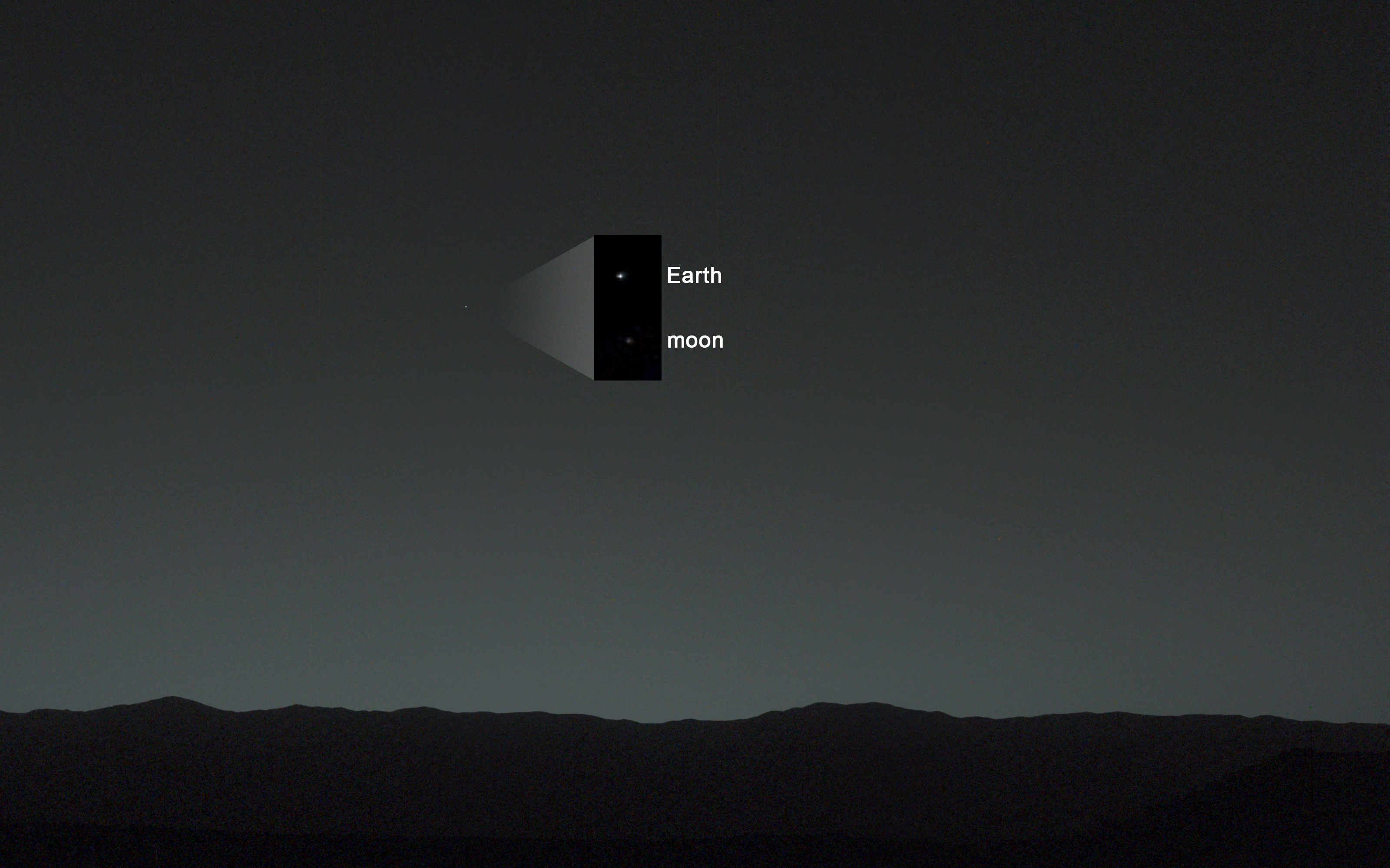
Annotated evening-sky view taken by NASA’s Mars rover Curiosity shows the Earth and Earth’s moon – enlarged in inset – as seen on Jan. 31, 2014, or Sol 529 shortly after sunset at the Dingo Gap sand dune. Credit: NASA/JPL-Caltech/MSSS/TAMU
Earth shines brilliantly as the brightest beacon in the Martian twilight sky view taken from the 1 ton rovers current location at the edge of a sand dune dubbed the ‘Dingo Gap.’
“A human observer with normal vision, if standing on Mars, could easily see Earth and the moon as two distinct, bright “evening stars,” said NASA in a statement issued today.
1st Curiosity Snapshot of Earth taken from here –
Curiosity’s View Past Tall Dune at edge of ‘Dingo Gap’ sand dune
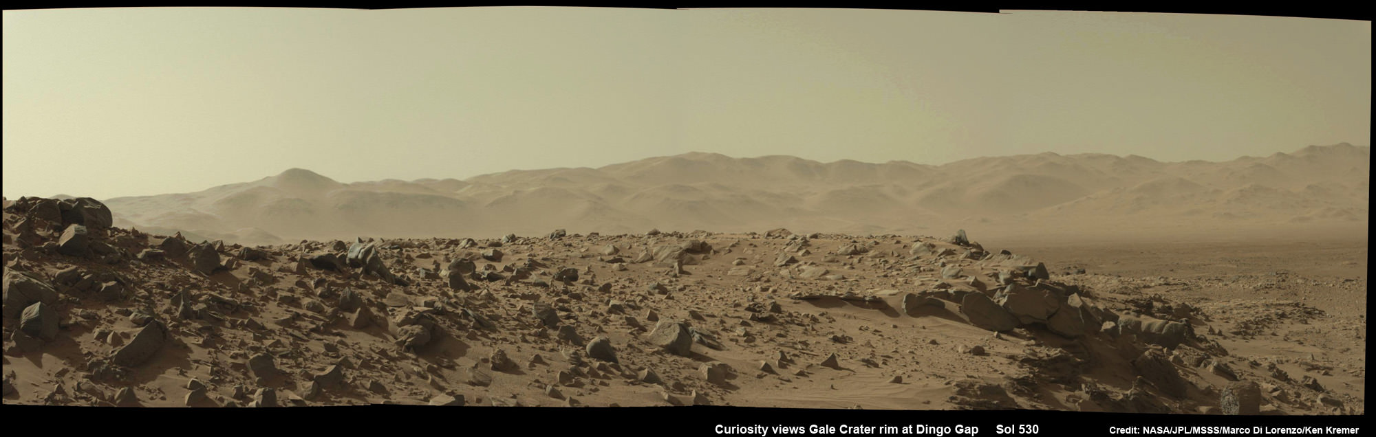
This photomosaic from Curiosity’s Navigation Camera (Navcam) taken at the edge of the entrance to the Dingo Gap shows a 3 foot (1 meter) tall dune and valley terrain beyond to the west, all dramatically back dropped by eroded rim of Gale Crater. View from the rover’s current position on Sol 528 (Jan. 30, 2014). The rover team may decide soon whether Curiosity will bridge the dune gap as a smoother path to next science destination.
Credit: NASA/JPL-Caltech/Marco Di Lorenzo/Ken Kremer- kenkremer.com
Curiosity used both of her high resolution mast mounted color cameras to collect a series of Earth/Moon images flittering across the Martian sky.
The Earth and the Moon in this evening-sky view taken by Curiosity’s telephoto Mastcam right -eye camera on Jan. 31, 2014, or Sol 529 shortly after sunset at the Dingo Gap. Moon’s brightness was enhanced to aid visibility. Credit: NASA/JPL-Caltech/MSSS/TAMU
Processing has removed the numerous cosmic ray strikes – see raw image below.
Right now Curiosity’s handlers are pondering whether to climb over the 1 meter tall sand dune and cross into the smooth terrain of the valley beyond the ‘Dingo Gap’ – as an alternate path to minimize damaging encounters with sharp edged Martian rocks that are puncturing holes and ripping tears into the robots six wheels.
To be clear, these are not the first images of the Earth from Mars orbit or Mars surface.
Two of NASA’s other Red Planet explorers also imaged Earth; Mars Global Surveyor in 2003 and Mars Reconnaissance Orbiter in 2007.
More recently, NASA’s Cassini orbiter at Saturn spied the Earth and Moon during the Wave at Saturn event in July 2013 from a distance of 898 million miles (1.44 billion kilometers).
And still more images of the Earth from NASA’s Mariner 10 and Juno Jupiter orbiter in my recent planetary exploration story – here
The most famous and distant of all is the ‘Pale Blue Dot’ image of Earth taken by NASA’s Voyager 1 probe in 1990 from about 6 billion kilometers (3.7 billion miles) away.
Stay tuned here for Ken’s continuing Curiosity, Opportunity, Chang’e-3, SpaceX, Orbital Sciences, LADEE, MAVEN, MOM, Mars and more planetary and human spaceflight news.
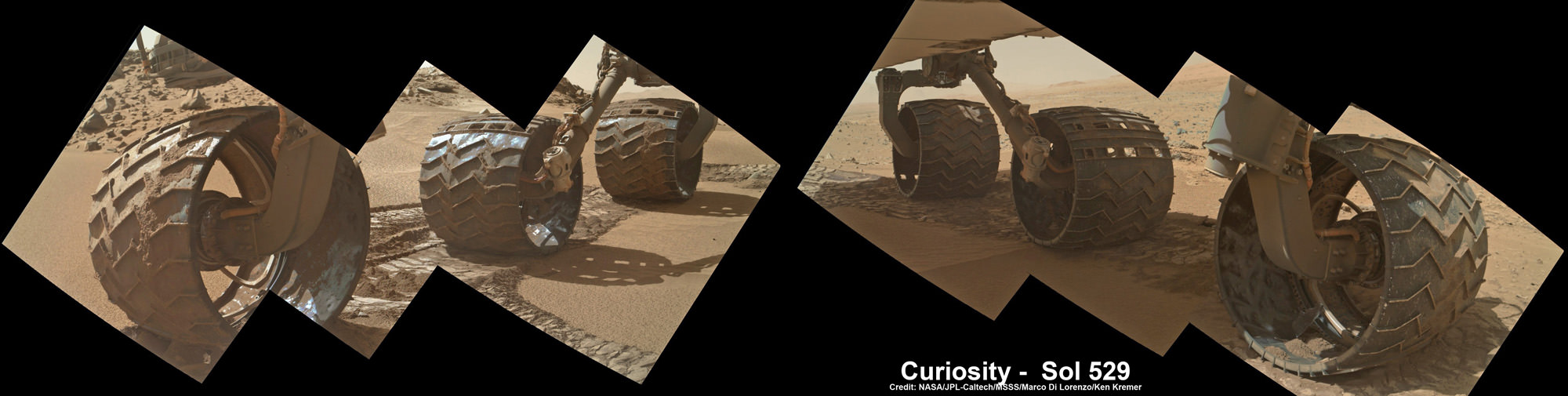
Curiosity Mastcam raw image showing the Earth in the Martian twilight sky on Jan. 31, 2014 amidst numerous cosmic ray strikes. . Credit: NASA/JPL-Caltech/MSSSCuriosity photographed You and all of humanity looking from somewhere above the eroded rim of Gale Crater – a portion of which is seen in this photomosaic taken by the same Mastcam camera on Feb 1, 2014, Sol 530, at the Dingo Gap sand dune. Credit: NASA/JPL-Caltech/MSSS/Marco Di Lorenzo/Ken Kremer- kenkremer.comPhotomosaic shows new holes and tears in several of rover Curiosity’s six wheels caused by recent driving over sharp edged Martian rocks on the months long trek to Mount Sharp. Raw images taken by the MAHLI camera on Curiosity’s arm on Jan. 31, 2014 (Sol 529) were assembled to show some recent damage to several of its six wheels. Credit: NASA / JPL / MSSS / Marco Di Lorenzo / Ken Kremer- kenkremer.com
Up close photomosaic view shows lengthy tear in rover Curiosity’s left front wheel caused by recent driving over sharp edged Martian rocks on the months long trek to Mount Sharp. Raw images taken by the MAHLI camera on Curiosity’s arm on Jan. 31, 2014 (Sol 529) were assembled to show some recent damage to several of its six wheels Credit: NASA / JPL / MSSS / Marco Di Lorenzo / Ken Kremer- kenkremer.com See below complete 6 wheel mosaic and further wheel mosaics for comparison
Up close photomosaic view shows lengthy tear in rover Curiosity’s left front wheel caused by recent driving over sharp edged Martian rocks on the months long trek to Mount Sharp. The team is evaluating an alternate, smoother way forward to next science target. Raw images taken by the MAHLI camera on Curiosity’s arm on Jan. 31, 2014 (Sol 529) were assembled to show some recent damage to several of its six wheels.
Credit: NASA / JPL / MSSS / Marco Di Lorenzo / Ken Kremer- kenkremer.com
See below complete 6 wheel mosaic and ‘Dingo Gap’ dune alternate route mosaic plus 3-D view[/caption]
Continuing wheel damage from hoards of sharp edged Martian rocks are forcing engineers to seek a smoother pathway forward – potentially through a treacherous dune field – for NASA’s Curiosity rover on the jagged rock strewn road to Mount Sharp, her primary science destination.
Ever since rover engineers noticed holes and tears to the robots six aluminum wheels this past fall and winter 2013, the team has been photographing the wheels much more frequently and carefully assessing their condition. See our mosaics above and below.
Curiosity’s handlers are now considering diverting the SUV-sized robot to an alternate path crossing into a dune field and the valley beyond that entails traversing through much smoother Martian terrain to reach a highly desirable and nearby science destination called “KMS-9.”
Newly received images taken by the robot only on Friday, Jan. 31, reveal a very significant ragged looking puncture at least 2 to 3 inches (5 to 8 cm) in length and a inch or so (3 cm) wide that’s bent back to the inside of the left front wheel.
Curiosity’s View Past Tall Dune at edge of ‘Dingo Gap’
This photomosaic from Curiosity’s Navigation Camera (Navcam) taken at the edge of the entrance to the Dingo Gap shows a 3 foot (1 meter) tall dune and valley terrain beyond to the west, all dramatically back dropped by eroded rim of Gale Crater. View from the rover’s current position on Sol 528 (Jan. 30, 2014). The rover team may decide soon whether Curiosity will bridge the dune gap as a smoother path to next science destination. Credit: NASA/JPL-Caltech/Marco Di Lorenzo/Ken Kremer- kenkremer.com
See NASA’s 3-D view of Dingo Gap below
Unfortunately, the fields of rough Red Planet rocks have not been a blessing to the 1 ton behemoth.
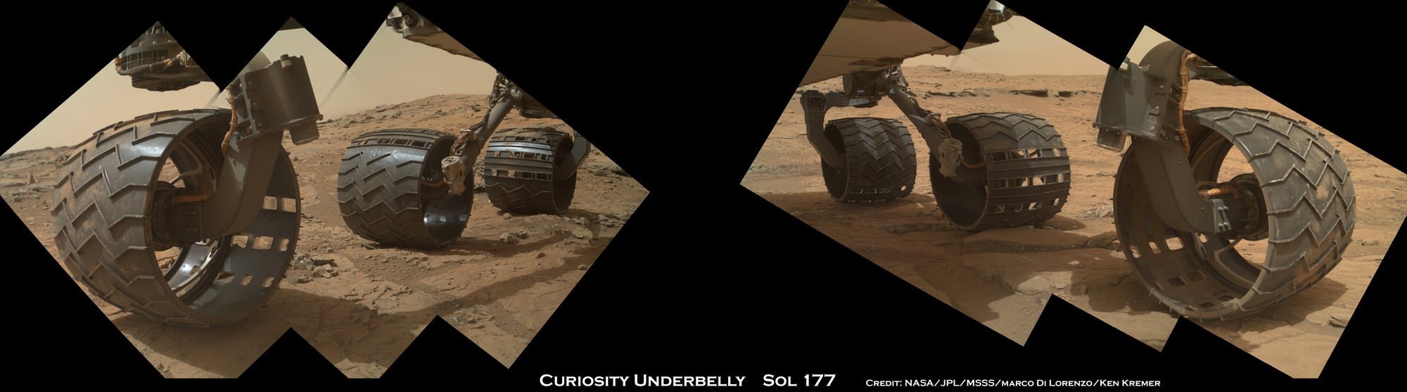
See our new underbelly mosaic view of Curiosity’s holy wheels (above and below) snapped on Jan. 31, (Sol 529), that’s aimed at the interior and which vividly shows the extent of the injury to the 20 inch diameter wheel.
Photomosaic shows new holes and tears in several of rover Curiosity’s six wheels caused by recent driving over sharp edged Martian rocks on the months long trek to Mount Sharp. Raw images taken by the MAHLI camera on Curiosity’s arm on Jan. 31, 2014 (Sol 529) were assembled to show some recent damage to several of its six wheels. Credit: NASA / JPL / MSSS / Marco Di Lorenzo / Ken Kremer- kenkremer.com
The rate of wheel damage has picked up dramatically as the driving pace accelerated across the rugged, rock filled Martian terrain over the past six months and put over 4.89 kilometers (3.04 mi.) on the odometer to date since the nailbiting August 2012 landing.
The mega robot is now standing at the edge of the dune field by the picturesque entrance known as the “Dingo Gap” after driving another 865 feet (264.7 meters) during January 2014.
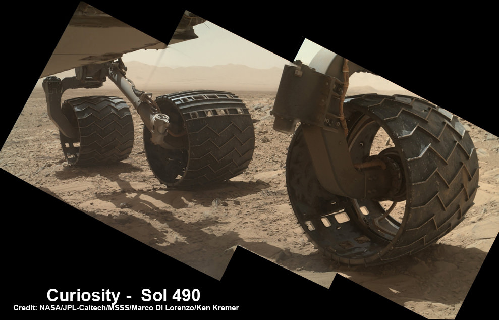
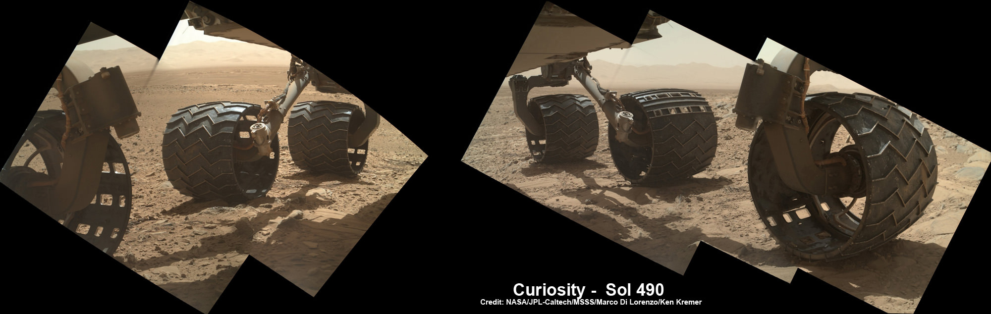
You can see the increased damage resulting from the past months drive by comparing the new Sol 529 view with our underbelly mosaic from Sol 490 in December 2013.
Photomosaic shows new holes and tears in several of rover Curiosity’s six wheels caused by recent driving over sharp edged Martian rocks on the months long trek to Mount Sharp. Raw images taken by the MAHLI camera on Curiosity’s arm on Dec. 22, 2013 (Sol 490) were assembled to show some recent damage to several of its six wheels – most noticeably the two here in middle and front. Credit: NASA / JPL / MSSS / Marco Di Lorenzo / Ken Kremer- kenkremer.com
However, the dune cutting across “Dingo Gap” measures about 3 feet (1 meter) in height.
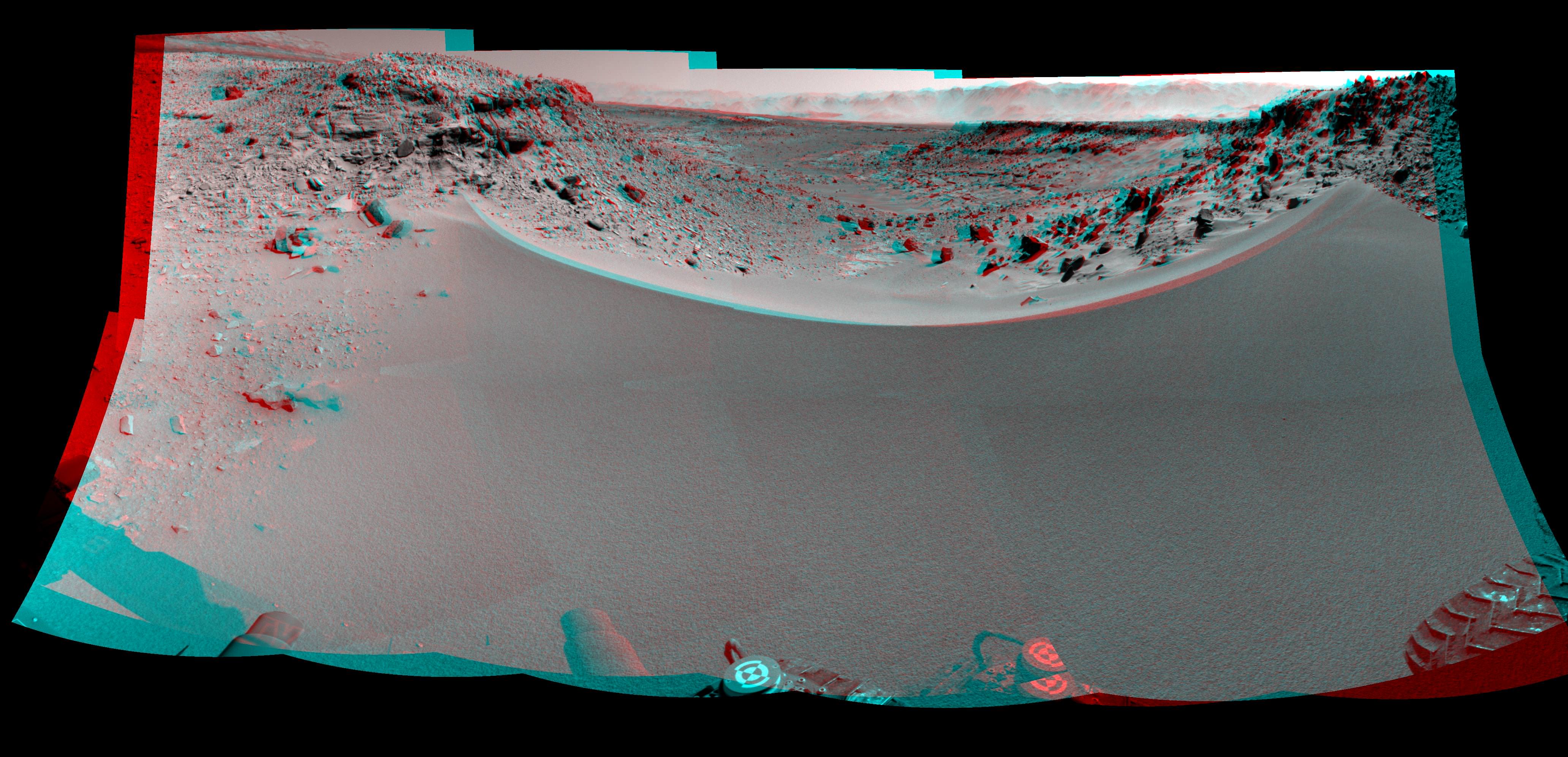
Look at this 3-D “Dingo Gap” mosaic view from NASA and you can judge for yourself the choices the team faces.
Curiosity’s 3-D View Past Tall Dune at edge of ‘Dingo Gap’
This stereo mosaic of images from the Navigation Camera (Navcam) on Curiosity shows the terrain to the west from the rover’s position on Sol 528 (Jan. 30, 2014). The scene appears three dimensional when viewed through red-blue glasses with the red lens on the left. The view was taken just after Curiosity had arrived at the eastern edge of a location called “Dingo Gap.” A dune across the gap is about 3 feet (1 meter) high in the middle and tapered at south (left) and north (right) ends onto low scarps on either side of the gap. The rover team is evaluating possible driving routes on the other side before a decision whether the cross the gap. Credit: NASA/JPL-Caltech
So the team is evaluating whether that’s safe to bridge because they don’t want to get stuck in a hidden sand trap like the one that ultimately led to Spirit’s demise a few years back.
“The decision hasn’t been made yet, but it is prudent to go check,” said Jim Erickson of NASA’s Jet Propulsion Laboratory, Pasadena, Calif., project manager for Curiosity, in a NASA statement.
Up close view of hole in one of rover Curiosity’s six wheels caused by recent driving over rough Martian rocks. Mosaic assembled from Mastcam raw images taken on Dec. 22, 2013 (Sol 490). Credit: NASA/JPL/MSSS/Ken Kremer -kenkremer.com/Marco Di Lorenzo
“We’ll take a peek over the dune into the valley immediately to the west to see whether the terrain looks as good as the analysis of orbital images implies,” Erickson added, based on orbital images snapped by the High Resolution Imaging Science Experiment (HiRISE) camera on NASA’s Mars Reconnaissance Orbiter (MRO) circling overhead.
The team is also testing an array of different driving techniques to minimize the accumulation of wheel punctures, such as driving backwards or using only four of the six wheels to reduce the force of the wheels pushing against jagged rocks.
The “Dingo Gap” could offer a safer gateway to “KMS-9” along the journey of the rovers southwestwardly route to breathtaking foothills of Mount Sharp.
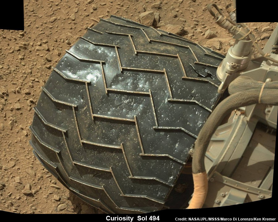
Curiosity Celebrates 500 Sols on Mars on Jan. 1, 2014. NASA’s Curiosity rover snaps fabulous new mosaic spying towering Mount Sharp destination looming dead ahead with her high resolution color cameras, in this cropped view. Imagery assembled from Mastcam raw images taken on Dec. 26, 2013 (Sol 494). Credit: NASA/JPL/MSSS/Marco Di Lorenzo/Ken Kremer- kenkremer.com
Dingo Gap lies between two low scarps and that is tapered off at both sides to the north and south.
KMS-9 is a potentially science rich target where the team hopes to conduct the first rock drilling operations since departing the Yellowknife Bay quadrant in July 2013.
The candidate drilling site lies only about half a mile (800 meters) away as the martian crow flies and features geology that’s appealing to the science team. But the roving routes under consideration are all much farther in actual distance.
“At KMS-9, we see three terrain types exposed and a relatively dust-free surface,” said science team collaborator Katie Stack of the California Institute of Technology, Pasadena.
Curiosity has already accomplished her primary goal of discovering a habitable zone on Mars that could support Martian microbes if they ever existed.
NASA’s rover Curiosity uncovered evidence that an ancient Martian lake had the right chemical ingredients, including clay minerals that could have sustained microbial life forms for long periods of time – and that these habitable conditions persisted on the Red Planet until a more recent epoch than previously thought.
As a result, the science team has shifted the missions focus to include the search for organic molecules – the building blocks of life as we know it – which may be preserved in the sedimentary rock layers of Mount Sharp.
“Really what we’re doing is turning the corner from a mission that is dedicated to the search for habitable environments to a mission that is now dedicated to the search for that subset of habitable environments which also preserves organic carbon,” Curiosity Principal Investigator John Grotzinger, of the California Institute of Technology in Pasadena, said recently at the Dec. 2013 annual meeting of the American Geophysical Union (AGU).
Meanwhile, NASA’s Opportunity rover is exploring clay mineral outcrops by the summit of Solander Point on the opposite side of the Mars at the start of her 2nd Decade investigating the Red Planets mysteries.
Read my new story about the Top 10 Decade 1 discoveries of Spirit and Opportunity – here.
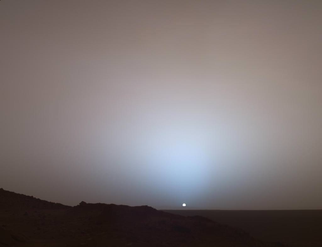
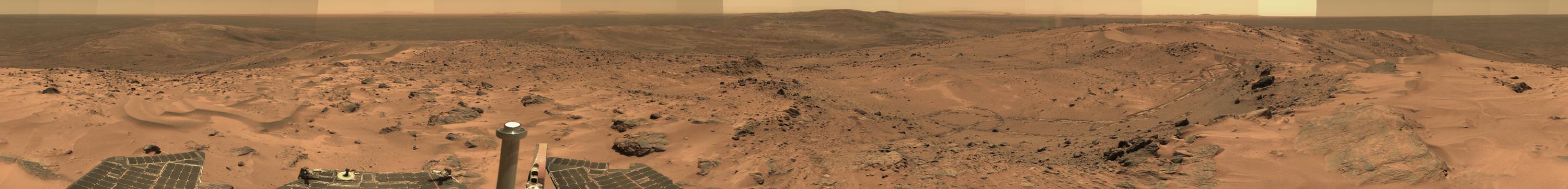
A Moment Frozen in Time On May 19th, 2005, NASA's Mars Exploration Rover Spirit captured this stunning view as the Sun sank below the rim of Gusev crater on Mars. This Panoramic Camera (Pancam) mosaic was taken around 6:07 in the evening of Sol 489. The terrain in the foreground is the rock outcrop "Jibsheet," a feature that Spirit has been investigating for several weeks (rover tracks are dimly visible leading up to "Jibsheet"). The floor of Gusev crater is visible in the distance, and the Sun is setting behind the wall of Gusev some 80 km (50 miles) in the distance. Credit: NASA/JPL-Caltech/Texas A&M/Cornell
A Moment Frozen in Time
On May 19th, 2005, NASA’s Mars Exploration Rover Spirit captured this stunning view as the Sun sank below the rim of Gusev crater on Mars. This Panoramic Camera (Pancam) mosaic was taken around 6:07 in the evening of Sol 489. The terrain in the foreground is the rock outcrop “Jibsheet,” a feature that Spirit has been investigating for several weeks (rover tracks are dimly visible leading up to “Jibsheet”). The floor of Gusev crater is visible in the distance, and the Sun is setting behind the wall of Gusev some 80 km (50 miles) in the distance.
Credit: NASA/JPL-Caltech/Texas A&M/Cornell
See photo gallery below[/caption]
But a decade ago, NASA’s six wheeled Spirit rover was but a promise of great things to come. And her rich Martian scientific heritage we know today was but a dream yet to ensue
Jan. 3 marks the 10th anniversary since her touchdown on Mars on Jan. 3, 2004. Her twin sister Opportunity soft landed 3 weeks later on Jan. 24, 2004.
So here’s a collection of some of Spirit’s greatest hits on the Red Planet for all to enjoy and remember her fabulous exploits.
Read my detailed new overview marking ‘Spirits 10 Years on Mars’ – here – with even more spectacular Red Planet imagery!
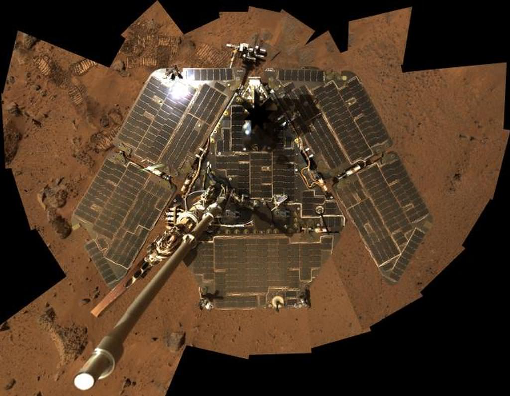
Empty Nest. Spirit rover images her Lander Platform after egress following touchdown in January 2004. Lander had 3-petals and airbags. Credit: NASA/JPL-Caltech/Cornell
Since the golf cart sized Spirit snapped over 128,000 raw images, drove 4.8 miles and ground into 15 rock targets we can’t show everything.
Here’s a retrospective of some of our favorites.
In this selfie, Spirit shows her solar panels gleaming in the Martian sunlight and carrying only a thin veneer of dust two years after the rover landed and began exploring the red planet. Spirit’s panoramic camera took this mosaic of images on Sol 586 (Aug. 27, 2005), as part of a mammoth undertaking. The vertical projection used here produces the best view of the rover deck itself, though it distorts the ground and antennas somewhat. This image is an approximate true-color rendering that combines images taken through the camera’s 600-nanometer, 530-nanometer and 480-nanometer filters. Credit: NASA/JPL-Caltech/Cornell
During her more than six year lifetime spanning until March 2010, Spirit discovered compelling evidence that ancient Mars exhibited hydrothermal activity, hot springs and volcanic explosions flowing with water.
“Spirit’s big scientific accomplishments are the silica deposits at Home Plate, the carbonates at Comanche, and all the evidence for hydrothermal systems and explosive volcanism, Rover Principal Investigator Steve Squyres of Cornell University, explained to me in an earlier interview.
“What we’ve learned is that early Mars at Spirit’s site was a hot, violent place, with hot springs, steam vents, and volcanic explosions. It was extraordinarily different from the Mars of today.”
Meanwhile, NASA’s new Curiosity rover just celebrated 500 Sols on Mars and is speeding towards Mount Sharp from inside Gale Crater – which is about the same size as Gusev crater.
Stay tuned here for Ken’s continuing Mars rover, Curiosity, Chang’e-3, SpaceX, Orbital Sciences, LADEE, MAVEN, MOM and more news.
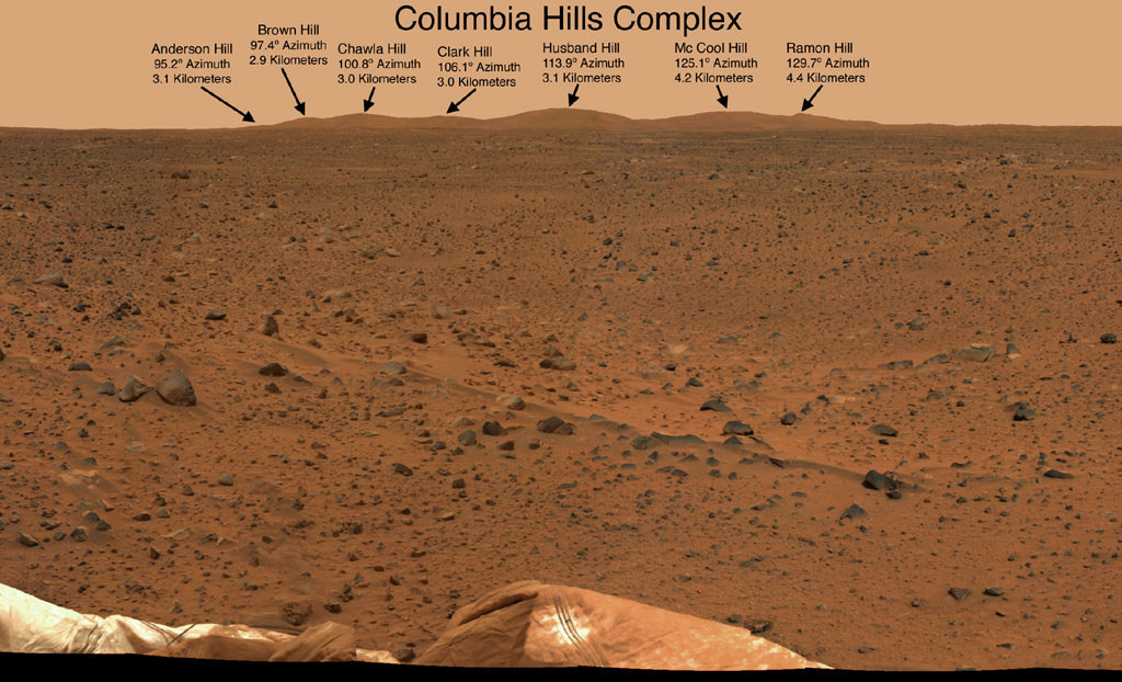
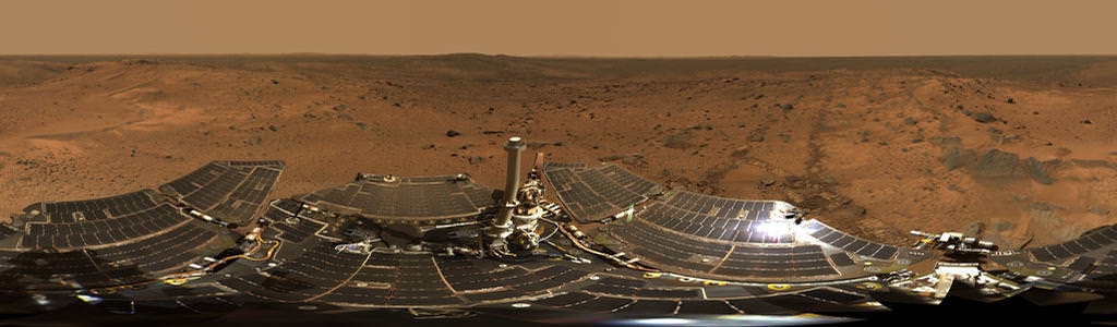
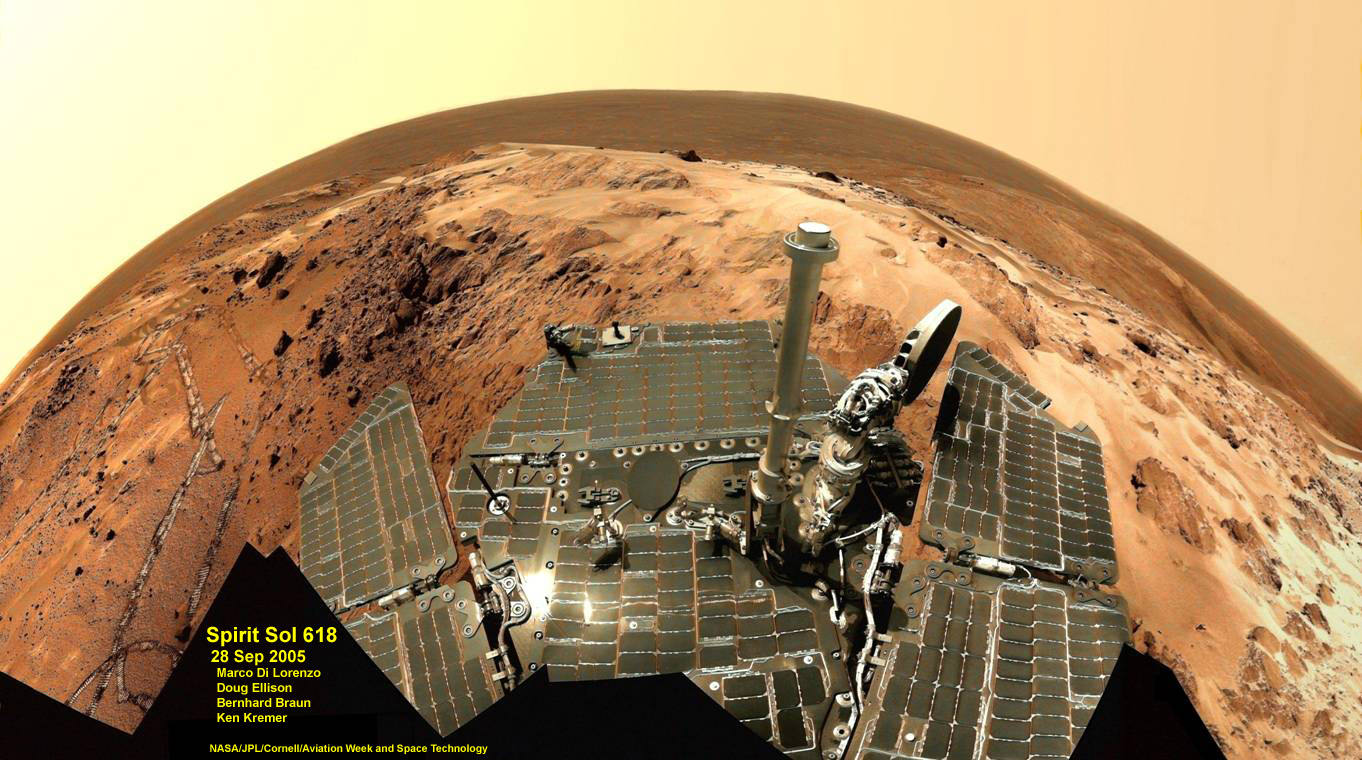
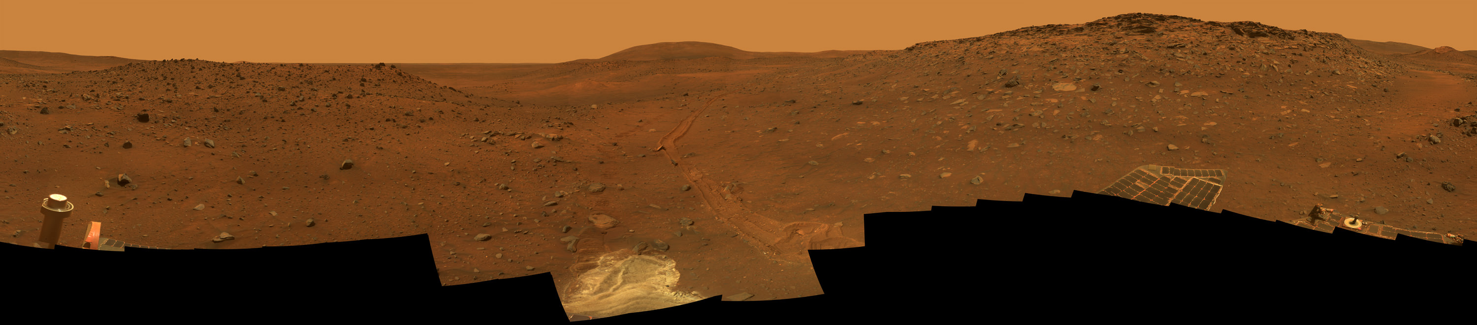
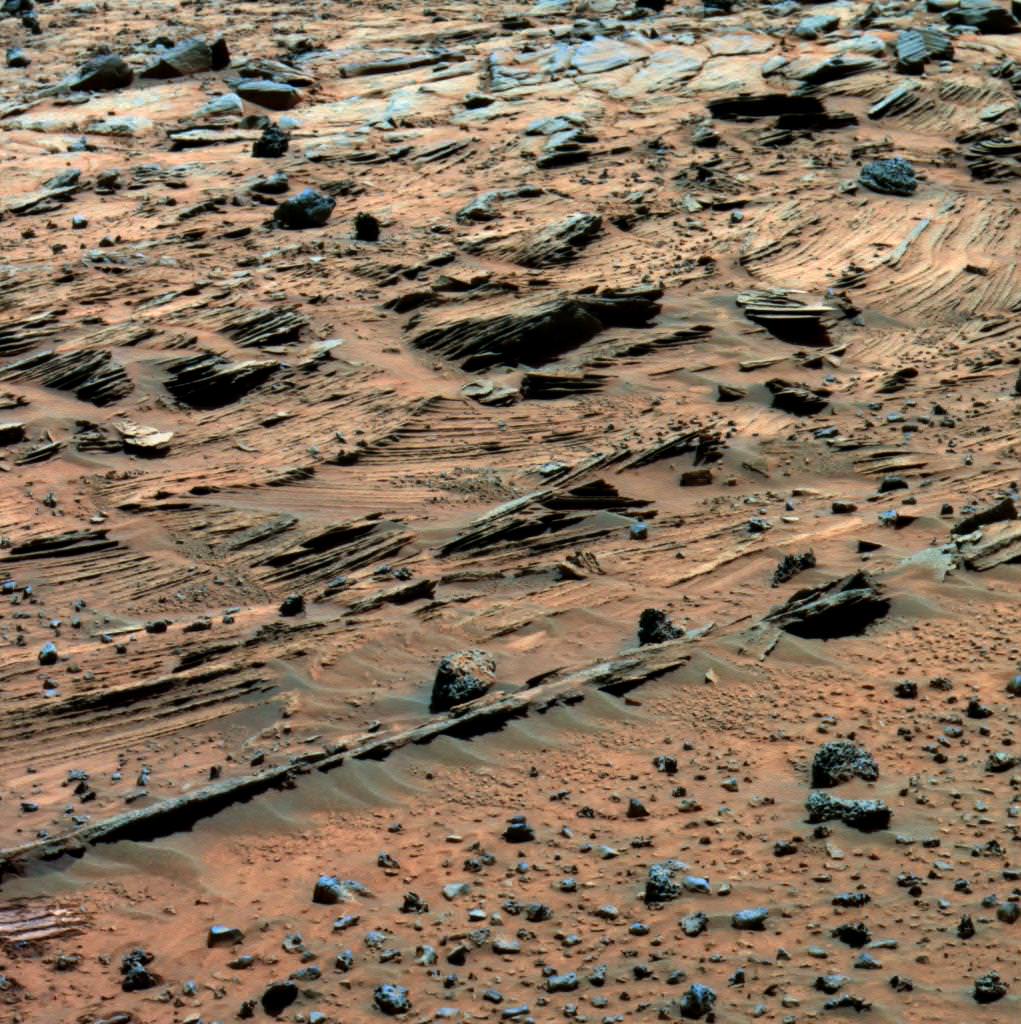
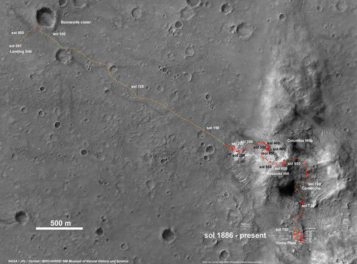
The “Columbia Hills” in Gusev Crater on Mars. “Husband Hill” is 3.1 kilometers distant. Spirit took this mosaic of images with the panoramic camera at the beginning of February, 2004, less than a month after landing on Mars. Spirit soon drove to the Columbia Hills and climbed to the summit of Husband Hill. Credit: NASA/JPL-Caltech/CornellSummit Panorama with Rover Deck The panoramic camera on Spirit took the hundreds of images combined into this 360-degree view, the “Husband Hill Summit” panorama. The images were acquired on Spirit’s sols 583 to 586 (Aug. 24 to 27, 2005), shortly after the rover reached the crest of “Husband Hill” inside Mars’ Gusev Crater. The panoramic camera shot 653 separate images in 6 different filters, encompassing the rover’s deck and the full 360 degrees of surface rocks and soils visible to the camera from this position. This was the first time the camera has been used to image the entire rover deck and visible surface from the same position. Credit: NASA/JPL-Caltech/CornellCarbonate-Containing Martian Rocks discovered by Spirit Mars Rover. Spirit collected data in late 2005 which confirmed that the Comanche outcrop contains magnesium iron carbonate, a mineral indicating the past environment was wet and non-acidic, possibly favorable to life. This view was captured during Sol 689 on Mars (Dec. 11, 2005). The find at Comanche is the first unambiguous evidence from either Spirit or Opportunity for a past Martian environment that may have been more favorable to life than the wet but acidic conditions indicated by the rovers’ earlier finds. Credit: NASA/JPL-Caltech/Cornell UniversityEverest Panorama from Husband Hill summit. It took Spirit three days, sols 620 to 622 (Oct. 1 to Oct. 3, 2005), to acquire all the images combined into this mosaic, called the “Everest Panorama”. Credit: NASA/JPL-Caltech/Cornell UniversitySpirit Mars rover – view from Husband Hill summit. Spirit snapped this unique self portrait view from the summit of Husband Hill inside Gusev crater on Sol 618 on 28 September 2005. The rovers were never designed or intended to climb mountains. It took more than 1 year for Spirit to scale the Martian mountain. This image was created from numerous raw images by an international team of astronomy enthusiasts and appeared on the cover of the 14 November 2005 issue of Aviation Week & Space Technology magazine and the April 2006 issue of Spaceflight magazine. Also selected by Astronomy Picture of the Day (APOD) on 28 November 2005. Credit: NASA/JPL/Cornell/ Marco Di Lorenzo/Doug Ellison/Bernhard Braun/Ken Kremer-kenkremer.com‘Calypso’ Panorama of Spirit’s View from ‘Troy’. This full-circle view from the panoramic camera (Pancam) on NASA’s Mars Exploration Rover Spirit shows the terrain surrounding the location called “Troy,” where Spirit became embedded in soft soil during the spring of 2009. The hundreds of images combined into this view were taken beginning on the 1,906th Martian day (or sol) of Spirit’s mission on Mars (May 14, 2009) and ending on Sol 1943 (June 20, 2009). Credit: NASA/JPL-Caltech/Cornell UniversitySpirit examined spectacular layered rocks exposed at “Home Plate.” The rover has drove around the northern and eastern edges of Home Plate. Before departing, Spirit took this image showing some of the most complex layering patterns seen so far at this location. Scientists suspect that the rocks at Home Plate were formed in the aftermath of a volcanic explosion or impact event, and they are investigating the possibility that wind may also have played a role in redistributing materials after such an event. Credit: NASA/JPL-Caltech/CornellSpirit Rover traverse map from Gusev Crater landing site to Home Plate: 2004 to 2011Spirit Rover traverse map from Husband Hill to resting place at Home Plate: 2004 to 2011
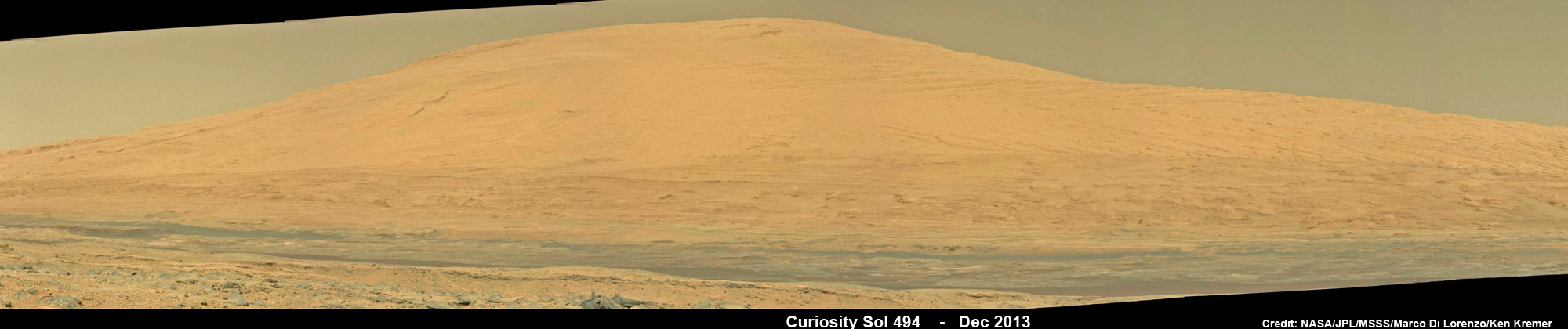
Curiosity Celebrates 500 Sols on Mars on Jan. 1, 2014. NASA’s Curiosity rover snaps fabulous new mosaic spying towering Mount Sharp destination looming dead ahead with her high resolution color cameras, in this cropped view. See full mosaic below. Imagery assembled from Mastcam raw images taken on Dec. 26, 2013 (Sol 494). Credit: NASA/JPL/MSSS/Marco Di Lorenzo/Ken Kremer- kenkremer.com
Curiosity Celebrates 500 Sols on Mars on Jan. 1, 2014
NASA’s Curiosity rover snaps fabulous new mosaic spying towering Mount Sharp destination looming dead ahead with her high resolution color cameras, in this cropped view. See full mosaic below. Imagery assembled from Mastcam raw images taken on Dec. 26, 2013 (Sol 494).
Credit: NASA/JPL/MSSS/Marco Di Lorenzo/Ken Kremer- kenkremer.com
Story updated[/caption]
Today, New Year’s Day 2014, NASA’s Curiosity mega rover celebrates a huge mission milestone – her 500th Martian Day on the Red Planet since the death defying touchdown of August 2012.
“500 Sols of Mars: While Earth celebrates #NewYear2014, midnight on Mars mark my 500th day of operations,” she tweeted today.
And Curiosity marked the grand occasion by snapping a fabulous new panorama spying towering Mount Sharp – looming dead ahead in her high resolution color cameras.
You can take in the magnificent Martian view Curiosity sees today – via our newly assembled mosaic of humongous Mount Sharp rising 5.5 kilometers (3.4 mi) into the Red Planets sky; see above and below.
Ascending mysterious Mount Sharp – which dominates the Gale Crater landing site – is the ultimate reason for Curiosity’s being.
Curiosity marks 500 Sols on Mars on New Year’s Day Jan. 1, 2014. Credit: NASA/JPL
NASA’s science and engineering teams dispatched the state-of-the-art robot there because they believe the lower sedimentary layers hold the clues to the time period when Mars was habitable eons ago and they possess the required chemical ingredients necessary to sustain microbial life.
But first she needs to reach the mountains foothills.
So, just like some Earthlings, Curiosity also set a New Year’s resolution she’d like to share with you all – just tweeted all the way from the Red Planet.
“Goals for 2014: Finish driving to Mars’ Mount Sharp & do all the science I can.”
Curiosity Celebrates 500 Sols on Mars on Jan. 1, 2014. NASA’s Curiosity rover snaps fabulous new mosaic spying towering Mount Sharp destination looming dead ahead with her high resolution color cameras. Imagery assembled from Mastcam raw images taken on Dec. 26, 2013 (Sol 494). Credit: NASA/JPL/MSSS/Marco Di Lorenzo/Ken Kremer- kenkremer.com
Part of those goals involve shifting the missions focus to include the search for organic molecules – the building blocks of life as we know it – which may be preserved in the sedimentary rock layers.
“Really what we’re doing is turning the corner from a mission that is dedicated to the search for habitable environments to a mission that is now dedicated to the search for that subset of habitable environments which also preserves organic carbon,” Curiosity Principal Investigator John Grotzinger, of the California Institute of Technology in Pasadena, said recently at the Dec. 2013 annual meeting of the American Geophysical Union (AGU).
The 1 ton behemoth is in the midst of an epic trek to destination Mount Sharp, roving across 10 kilometers (6 mi.) of the rather rocky crater floor of her landing site inside Gale Crater.
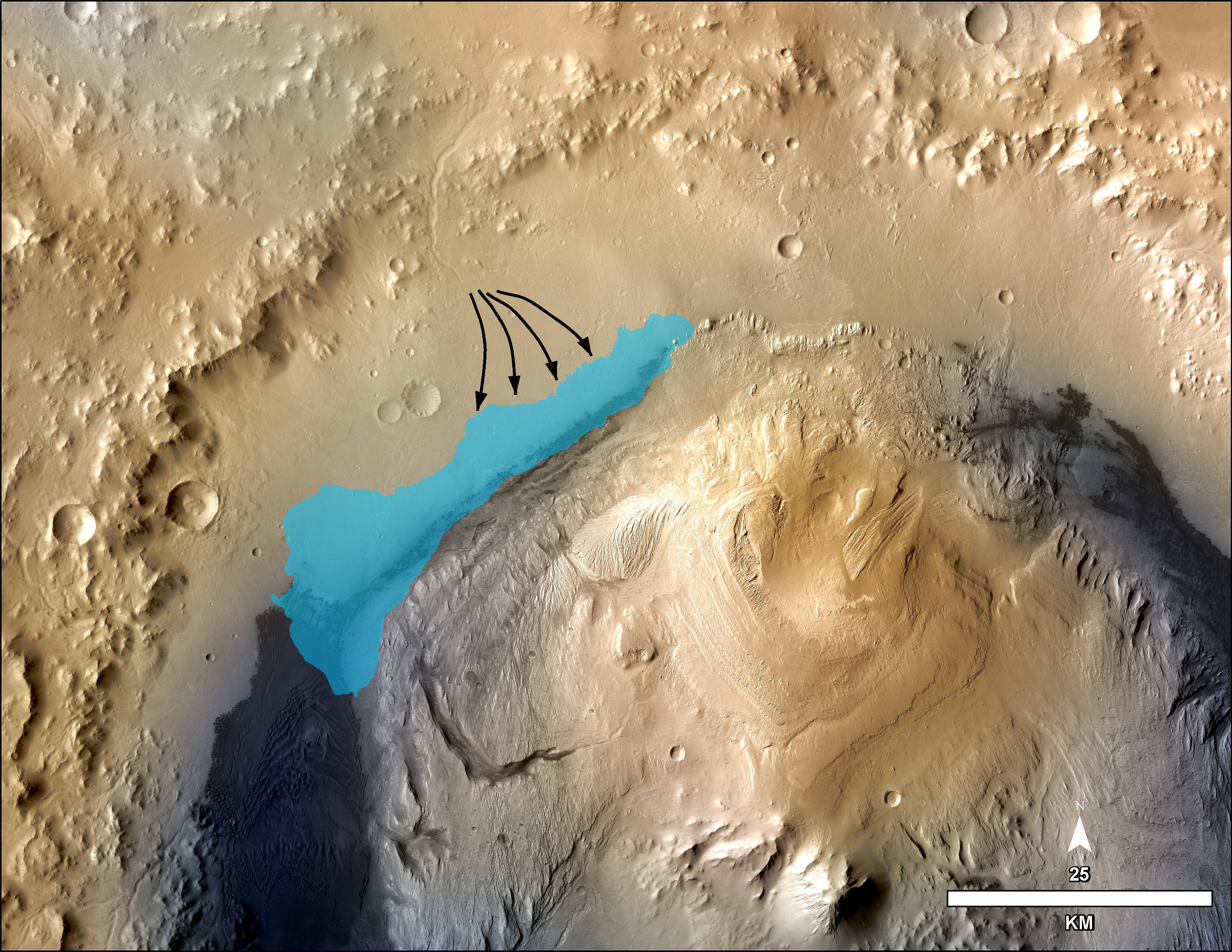
This illustration depicts a concept for the possible extent of an ancient lake inside Gale Crater. The existence of a lake there billions of years ago was confirmed by Curiosity from examination of mudstone in the crater’s Yellowknife Bay area. Credit: NASA/JPL-Caltech/MSSS
But the alien crater floor strewn with a plethora of sharp edged rocks is ripping significant sized holes and causing numerous dents in several of the rovers six big aluminum wheels – as outlined in my prior report; here.
Photomosaic shows new holes and tears in several of rover Curiosity’s six wheels caused by recent driving over sharp edged Martian rocks on the months long trek to Mount Sharp. Raw images taken by the MAHLI camera on Curiosity’s arm on Dec. 22, 2013 (Sol 490) were assembled to show some recent damage to several of its six wheels – most noticeably the two here in middle and front. Credit: NASA / JPL / MSSS / Marco Di Lorenzo / Ken Kremer- kenkremer.com
“Routes to future destinations for the mission may be charted to lessen the amount of travel over such rough terrain, compared to smoother ground nearby,” says NASA.
So far Curiosity’s odometer stands at 4.6 kilometers, following a post Christmas drive on Dec. 26, 2013 (Sol 494) after 16 months roving the Red Planet.
Curiosity’s handlers will be diligently watching the wear and tear on the 20 inch diameter wheels. She needs to rove along a smoother path forward to minimize wheel damage by sharp rocks.
Here’s our latest wheel mosaic from Dec. 26, 2013 (Sol 494) showing a several centimeter wide puncture in the left front wheel, which seems to have suffered the most damage.
The Mount Sharp and wheel mosaics were assembled by the imaging team of Marco Di Lorenzo and Ken Kremer.
Up close view of puncture in one of rover Curiosity’s six wheels caused by recent driving over rough Martian rocks. Mosaic assembled from Mastcam raw images taken on Dec. 26, 2013 (Sol 494) Credit: NASA/JPL/MSSS/Ken Kremer -kenkremer.com/Marco Di Lorenzo
“Taking stock this holiday season. I’m planning smoother paths for the new year,” Curiosity tweeted.
The team hopes the intrepid robot arrives at the base of Mount Sharp around the middle of this new year 2014, if all goes well.
Shortly thereafter the robot begins a new phase with the dramatic ascent up the chosen entryway which the team dubs the ‘Murray Buttes’ – fittingly named in honor of Bruce Murray, a Caltech planetary geologist, who worked on science teams of NASA’s earliest missions to Mars in the 1960s and ’70s.
The rocky road ahead towards the base of Mount Sharp and the Murray Buttes entry point is shown in this mosaic from Dec. 26, 2013 (Sol 494). Curiosity needs to rove along a smoother path forward to minimize wheel damage by sharp rocks. Credit: NASA/JPL/MSSS/Marco Di Lorenzo/Ken Kremer
Murray also was the director of NASA’s Jet Propulsion Laboratory from 1976 to 1982 and co-founded the Planetary Society in 1980. He passed away on Aug. 29, 2013.
“Bruce Murray contributed both scientific insight and leadership that laid the groundwork for interplanetary missions such as robotic missions to Mars, including the Mars rovers, part of America’s inspirational accomplishments. It is fitting that the rover teams have chosen his name for significant landmarks on their expeditions,” said NASA Mars Exploration Program Manager Fuk Li, of NASA’s Jet Propulsion Laboratory (JPL) , Pasadena, Calif.
Curiosity has already accomplished her primary goal of discovering a habitable zone on Mars that could support Martian microbes if they ever existed.
NASA’s rover Curiosity uncovered evidence that an ancient Martian lake had the right chemical ingredients, including clay minerals that could have sustained microbial life forms for long periods of time – and that these habitable conditions persisted on the Red Planet until a more recent epoch than previously thought.
Photomosaic shows new holes and tears in several of rover Curiosity’s six wheels caused by recent driving over sharp edged Martian rocks on the months long trek to Mount Sharp. Raw images taken by the MAHLI camera on Curiosity’s arm on Dec. 22, 2013 (Sol 490) were assembled to show some recent damage to several of its six wheels – most noticeably the two here in middle and front. Credit: NASA / JPL / MSSS / Marco Di Lorenzo / Ken Kremer- kenkremer.com
See below complete 6 wheel mosaic and further wheel mosaics for comparison
Photomosaic shows new holes and tears in several of rover Curiosity’s six wheels caused by recent driving over sharp edged Martian rocks on the months long trek to Mount Sharp. Raw images taken by the MAHLI camera on Curiosity’s arm on Dec. 22, 2013 (Sol 490) were assembled to show some recent damage to several of its six wheels – most noticeably the two here in middle and front. Credit: NASA / JPL / MSSS / Marco Di Lorenzo / Ken Kremer- kenkremer.com See below complete 6 wheel mosaic and further wheel mosaics for comparison [/caption]
Several of the NASA rovers six big aluminum wheels have suffered some significant sized rips, tears and holes up to several centimeters wide – in addition to numerous dents – as she has picked up the driving pace across the rugged, rock filled Martian terrain this past fall and put over 4.5 kilometers (3 mi.) on the odometer to date.
It’s rather easy to spot the wheel damage to the 1 ton behemoth by examining the mosaic imagery we have created – See above and below – from newly transmitted raw imagery and comparing that to older imagery taken at earlier points in the mission. Check our Sol 177 wheels mosaic below.
The latest imagery from Mars captured just prior to Christmas is delivering an undesired holiday present of sorts to team members that might well cause the scientists and engineers to alter Curiosity’s extraterrestrial road trip to traverse smoother terrain and thereby minimize future harm.
So the wheel damage is certainly manageable at this point but will require attention.
The team of Marco Di Lorenzo and Ken Kremer have assembled the new Mastcam and MAHLI raw images of the wheels captured on Sol 490 (Dec. 22) into fresh color mosaics – shown herein.
Photomosaic shows new holes and tears in several of rover Curiosity’s six wheels caused by recent driving over sharp edged Martian rocks on the months long trek to Mount Sharp. Raw images taken by the MAHLI camera on Curiosity’s arm on Dec. 22, 2013 (Sol 490) were assembled to show some recent damage to several of its six wheels – most noticeably the two at right in middle and front. Credit: NASA / JPL / MSSS / Marco Di Lorenzo / Ken Kremer- kenkremer.com
See below more wheel mosaics for comparisonPhotomosaic from Sol 177 (Feb. 3, 2013) shows rover Curiosity’s six wheels relatively intact with far fewer holes and dents compared to Sol 490 mosaic taken on Dec 22. 2013. Rover is working in Yellowknife Bay here and had not yet begun long trek to Mount Sharp. Sol 177 raw images assembled to mosaic were taken by the MAHLI camera on Curiosity’s arm. Credit: NASA/JPL/MSSS/Marco Di Lorenzo/Ken Kremer- kenkremer.com
Indeed the rovers handlers have already directed the SUV sized Curiosity to snap close up images of the 20 inch diameter wheels with the high resolution color cameras located on the Mast as well as the Mars Hand Lens Imager (MAHLI) camera at the end of the rover’s maneuverable robotic arm.
“We want to take a full inventory of the condition of the wheels,” said Jim Erickson of NASA’s Jet Propulsion Laboratory, project manager for the NASA Mars Science Laboratory Project, in a NASA statement.
Up close view of hole in one of rover Curiosity’s six wheels caused by recent driving over rough Martian rocks. Mosaic assembled from Mastcam raw images taken on Dec. 22, 2013 (Sol 490) Credit: NASA/JPL/MSSS/Ken Kremer -kenkremer.com/Marco Di Lorenzo
The rover team certainly expected some wear and tear to accumulate along the rock strewn path to the base of Mount Sharp – which reaches 5.5 km (3.4 mi) into the Martian sky.
But the volume of sharp edged rocks encountered in the momentous trek across the floor of Curiosity’s Gale Crater landing site apparently has picked up- as evidenced by the new pictures – and consequently caused more damage than the engineers anticipated.
“Dents and holes were anticipated, but the amount of wear appears to have accelerated in the past month or so,” Erickson noted.
“It appears to be correlated with driving over rougher terrain. The wheels can sustain significant damage without impairing the rover’s ability to drive. However, we would like to understand the impact that this terrain type has on the wheels, to help with planning future drives.”
The team is now inspecting the new imagery acquired of the wheels and will decide if a course alteration to Mount Sharp is in order.
The left front wheel may have suffered the most harm.
Up close view shows a tear in one of rover Curiosity’s six wheels caused by recent driving over rough Martian rocks. Mosaic assembled from Mastcam raw images taken on Dec. 22, 2013 (Sol 490) Credit: NASA/JPL/MSSS/Ken Kremer -kenkremer.com/Marco Di Lorenzo
“Routes to future destinations for the mission may be charted to lessen the amount of travel over such rough terrain, compared to smoother ground nearby,” says NASA.
Following a new, post Christmas drive today, Dec. 26, 2013 (Sol 494) Curiosity’s odometer stands at 4.6 kilometers.
Curiosity has already accomplished her primary goal of discovering a habitable zone on Mars that could support Martian microbes if they ever existed.
NASA’s rover Curiosity uncovered evidence that an ancient Martian lake had the right chemical ingredients that could have sustained microbial life forms for long periods of time – and that these habitable conditions persisted on the Red Planet until a more recent epoch than previously thought.
Right now the researchers are guiding Curiosity along a 10 km (6 mi) path to the lower reaches of Mount Sharp – which they hope to reach sometime in mid 2014.
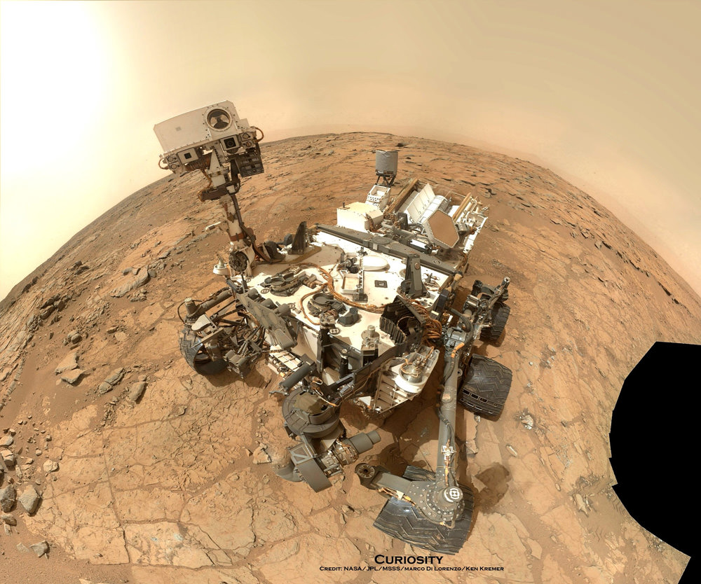
NASA’s Mars rover Curiosity took this self-portrait, composed of more than 50 images using its robotic arm-mounted MAHLI camera, on Feb. 3. The image shows Curiosity at the John Klein drill site. A drill hole is visible at bottom left. Credit: NASA / JPL / MSSS / Marco Di Lorenzo / Ken Kremer- kenkremer.com
Stay tuned here for Ken’s continuing Curiosity, Chang’e-3, LADEE, MAVEN, Mars rover and MOM news.
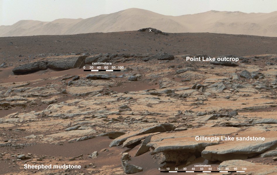
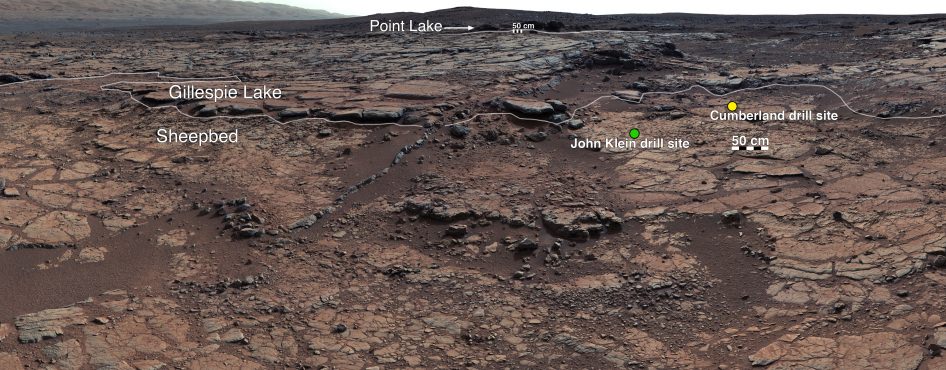
Outcrops in Yellowknife Bay are being exposed by wind driven erosion. These rocks record superimposed ancient lake and stream deposits that offered past environmental conditions favorable for microbial life. This image mosaic from the Mast Camera instrument on NASA's Curiosity Mars rover shows a series of sedimentary deposits in the Glenelg area of Gale Crater, from a perspective in Yellowknife Bay looking toward west-northwest. The "Cumberland" rock that the rover drilled for a sample of the Sheepbed mudstone deposit (at lower left in this scene) has been exposed at the surface for only about 80 million years. Credit: NASA/JPL-Caltech/MSSS
NASA’s Curiosity rover has discovered evidence that an ancient Martian lake had the right chemical ingredients that could have sustained microbial life forms for long periods of time – and that these habitable conditions persisted on the Red Planet until a more recent epoch than previously thought.
Furthermore researchers have developed a novel technique allowing Curiosity to accurately date Martian rocks for the first time ever – rather than having to rely on educated guesses based on counting craters.
All that and more stems from science results just announced by members of the rover science team.
Researchers outlined their remarkable findings in a series of six new scientific papers published today (Dec. 9) in the highly respected journal Science and at talks held today at the Fall 2013 Annual Meeting of the American Geophysical Union (AGU) in San Francisco.
The Curiosity team also revealed that an investigation of natural Martian erosion processes could be used to direct the rover to spots with a higher likelihood of holding preserved evidence for the building blocks of past life – if it ever existed.
View of Yellowknife Bay Formation, with Drilling Sites
This mosaic of images from Curiosity’s Mast Camera (Mastcam) shows geological members of the Yellowknife Bay formation, and the sites where Curiosity drilled into the lowest-lying member, called Sheepbed, at targets “John Klein” and “Cumberland.” The scene has the Sheepbed mudstone in the foreground and rises up through Gillespie Lake member to the Point Lake outcrop. These rocks record superimposed ancient lake and stream deposits that offered past environmental conditions favorable for microbial life. Rocks here were exposed about 70 million years ago by removal of overlying layers due to erosion by the wind. Credit: NASA/JPL-Caltech/MSSS
The ancient fresh water lake at the Yellowknife Bay area inside the Gale Crater landing site explored earlier this year by Curiosity existed for periods spanning perhaps millions to tens of millions of years in length – before eventually evaporating completely after Mars lost its thick atmosphere.
Furthermore the lake may have existed until as recently as 3.7 Billion years ago, much later than researchers expected which means that life had a longer and better chance of gaining a foothold on the Red Planet before it was transformed into its current cold, arid state.
NASA’s Mars rover Curiosity took this self-portrait, composed of more than 50 images using its robotic arm-mounted MAHLI camera, on Feb. 3. The image shows Curiosity at the John Klein drill site. A drill hole is visible at bottom left. Credit: NASA / JPL / MSSS / Marco Di Lorenzo / Ken Kremer- kenkremer.com
Researchers also announced that they are shifting the missions focus from searching for habitable environments to searching for organic molecules – the building blocks of all life as we know it.
Why the shift? Because the team believes they have found a way to increase the chance of finding organics preserved in the sedimentary rock layers.
“Really what we’re doing is turning the corner from a mission that is dedicated to the search for habitable environments to a mission that is now dedicated to the search for that subset of habitable environments which also preserves organic carbon,” Curiosity Principal Investigator John Grotzinger, of the California Institute of Technology in Pasadena, said at an AGU press conference today.
“That’s the step we need to take as we explore for evidence of life on Mars.”
Earlier this year, Curiosity drilled into a pair of sedimentary Martian mudstone rock outcrops at Yellowknife Bay known as “John Klein” and “Cumberland” – for the first time in history.
Grotzinger said the ancient lake at Yellowknife Bay was likely about 30 miles long and 3 miles wide.
Powdered samples deposited into the rovers miniaturized chemistry labs – SAM and CheMin – revealed the presence of significant levels of phyllosilicate clay minerals.
These clay minerals form in neutral pH water that is ‘drinkable” and conducive to the formation of life.
“Curiosity discovered that the fine-grained sedimentary rocks preserve evidence of an environment that would have been suited to support a Martian biosphere founded on chemolithoautotrophy,” according to one of the science papers co-authored by Grotzinger.
“This aqueous environment was characterized by neutral pH, low salinity, and variable redox states of both iron and sulfur species.”
The rover has detected key elements required for life including carbon, hydrogen, oxygen, sulfur nitrogen and phosphorous.
The team is still looking for signatures of organic molecules.
Right now the researchers are driving Curiosity along a 6 mile path to the base of Mount Sharp -the primary mission destination – which they hope to reach sometime in Spring 2014.
But along the way they hope to stop at a spot where wind has eroded the sedimentary rocks just recently enough to expose an area that may still preserve evidence for organic molecules – since it hasn’t been bombarded by destructive cosmic radiation for billions of years.
Stay tuned here for Ken’s continuing Curiosity, Chang’e 3, LADEE, MAVEN and MOM news.
Dec 11: “Curiosity, MAVEN and the Search for Life on Mars”, “LADEE & Antares ISS Launches from Virginia”, Rittenhouse Astronomical Society, Franklin Institute, Phila, PA, 8 PM
NASA's Mars rover Curiosity took this self-portrait, composed of more than 50 images using its robotic arm-mounted MAHLI camera, on Feb. 3, 2013. The image shows Curiosity at the John Klein drill site. A drill hole is visible at bottom left. Credit: NASA / JPL / MSSS / Marco Di Lorenzo / Ken Kremer- kenkremer.com
CAPE CANAVERAL, FL – NASA’s car sized CuriosityMars rover has resumed full science operations and driving following a six day long halt to research activities due to concerns about an electrical power system glitch, which have now been resolved.
On Nov. 17, engineers noticed a fluctuation in voltage on Curiosity that caused the robots handlers to stop science activities and driving towards mysterious Mount Sharp while they searched for the root cause of the electrical issue.
NASA says that the voltage change did not impact the rovers safety or health and the team was acting out of an abundance of caution while investigating the situation from millions of miles away back on Earth.
“The vehicle’s electrical system has a “floating bus” design feature to tolerate a range of voltage differences between the vehicle’s chassis — its mechanical frame — and the 32-volt power lines that deliver electricity throughout the rover. This protects the rover from electrical shorts,” NASA said in a statement.
Curiosity’s voltage level had been about 11 volts since landing day and had declined to about 4 volts on Nov. 17. The electrical issue did not trigger the rover to enter a safe-mode status.
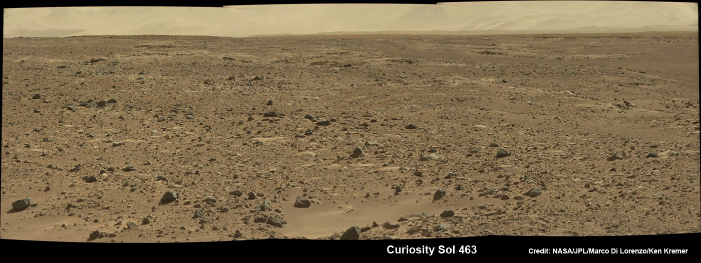
Curiosity scans the Martian landscape to the distant rim of Gale Crater landing site on Sol 463, November 2013. Credit: NASA / JPL / MSSS / Marco Di Lorenzo / Ken Kremer- kenkremer.com
Engineers amassed a list of possible causes for the voltage change while suspending science operations and roving across the Martian crater floor where Curiosity landed nearly a year and a half ago in August 2012.
“We made a list of potential causes, and then determined which we could cross off the list, one by one,” said rover electrical engineer Rob Zimmerman of NASA’s Jet Propulsion Laboratory, Pasadena, Calif.
NASA says that the likely cause is an internal short stemming from the Radioisotope Thermoelectric Generator (RTG) – the rovers nuclear power source.
RTG’s have been commonly used on many NASA missions that also experienced occasional shorts and that had no long term impact or loss of capability on their flights.
“This type of intermittent short has been seen in similar RTGs, including the one on the Cassini spacecraft, which has been orbiting Saturn for years. The rover electronics are designed to operate at variable power supply voltages, so this is not a major problem,” says Curiosity team member Ken Herkenhoff of the USGS in a mission update.
The voltage level had returned its normal level of 11 volts on its own by Nov. 23, when the team had decided to resume science operations.
So it is possible that the same type of intermittent voltage change could recur in the future.
Meanwhile the rover has resumed her epic trek to Mount Sharp and is expected to arrive at the base of the mountain sometime in mid-2014.
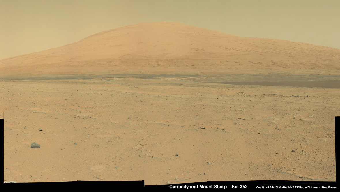
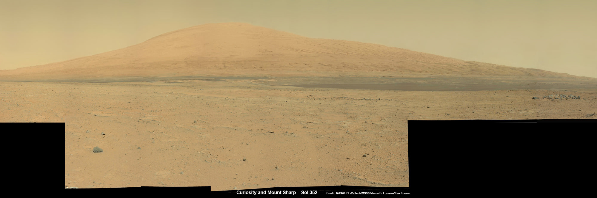
Curiosity Spies Mount Sharp – her primary destination. Curiosity will ascend mysterious Mount Sharp and investigate the sedimentary layers searching for clues to the history and habitability o the Red Planet of billions of years. This mosaic was assembled from Mastcam camera images taken on Sol 352 (Aug 2, 2013). Credit: NASA/JPL-Caltech/MSSS/ Marco Di Lorenzo/Ken Kremer
This past weekend, the robot delivered additional portions of powdered rock to the CheMin and SAM labs inside the rover. The sample was collected 6 months ago after drilling into a rock nicknamed “Cumberland” and will supplement prior measurements.
Curiosity has already accomplished her primary science goal of discovering a habitable zone at her landing site.
Scientists expect to broaden the region of Martian habitability once the 1 ton robot begins the ascent of Mount Sharp to investigate the sedimentary layers in the lower reaches of the towering 3 mile (5 km) high mountain, that record Mars geologic and climatic history over a time span of billions of years.
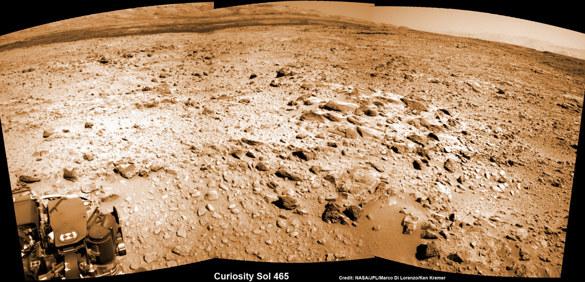
Curiosity looks to the base of Mount Sharp and the Murray buttes – her ultimate climbing destination – in this mosaic assembled from navcam camera images from Sol 465, November 2013. Credit: NASA / JPL / MSSS / Marco Di Lorenzo / Ken Kremer- kenkremer.com
And as both of NASA’s rovers Curiosity and Opportunity ascend Martian mountains, they’ll be joined next September 2014 by a pair of new Martian orbiters from the US and India – MAVEN and MOM – that will significantly expand Earth’s invasion force at the Red Planet.
Stay tuned here for continuing Mars rover, MOM and MAVEN news and Ken’s MAVEN and SpaceXFalcon 9 launch reports from on site at the Kennedy Space Center press center and Cape Canaveral Air Force Station, Florida.
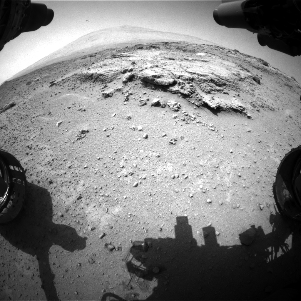
Curiosity’s views a rock outcrop after arriving for a short stay at ‘Waypoint 1’- dramatically back dropped by her primary destination, Mount Sharp. Front hazcam camera image from Sol 393 (Sept 13, 2013). Credit: NASA/JPL-Caltech
Curiosity’s views a rock outcrop at ‘Darwin’ after arriving for a short stay at ‘Waypoint 1’ on Sept 12 (Sol 392) – dramatically back dropped by her primary destination, Mount Sharp. Front hazcam camera image from Sol 393 (Sept 13, 2013). Credit: NASA/JPL-Caltech
Story updated – see close up mosaic views of Darwin outcrop below[/caption]
NASA’s Curiosity Mars rover has just rolled into an intriguing site called ‘Darwin’ at ‘Waypoint 1’- having quickly picked up the driving pace since embarking at last on her epic trek to mysterious Mount Sharp more than two months ago. Did life giving water once flow here on the Red Planet?
Because the long journey to Mount Sharp – the robots primary destination – was certain to last nearly a year, the science team carefully choose a few stopping points for study along the way to help characterize the local terrain. And Curiosity has just pulled into the first of these so called ‘Waypoints’ on Sept 12 (Sol 392), the lead scientist confirmed to Universe Today.
“Curiosity has arrived at Waypoint 1,” project scientist John Grotzinger, of the California Institute of Technology in Pasadena, told Universe Today.
“Darwin is named after a geologic formation of rocks from Antarctica.”
She has now driven nearly 20% of the way towards the base of the giant layered Martian mountain she will eventually scale in search of life’s ingredients.
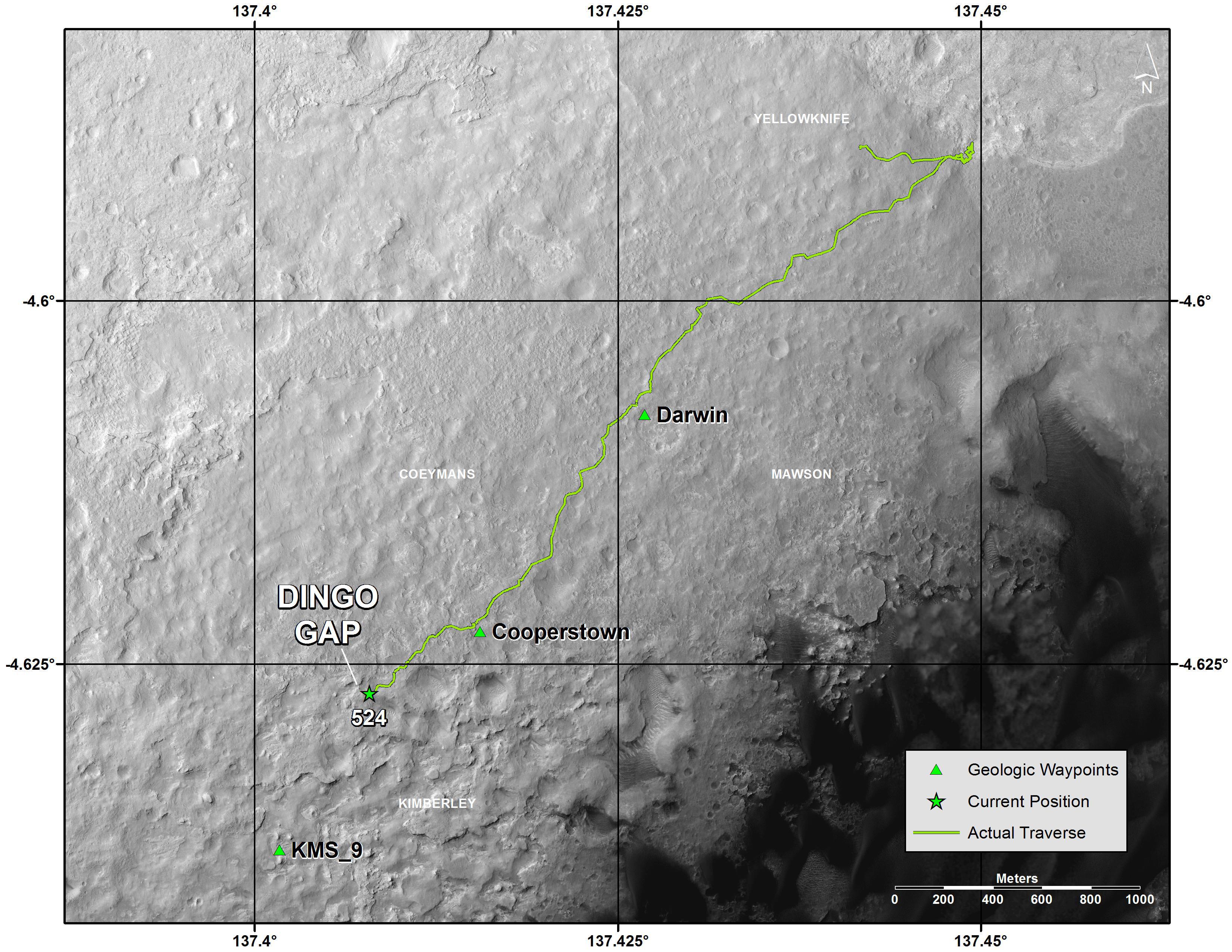
Altogether, the team selected five ‘Waypoints’ to investigate for a few days each as Curiosity travels in a southwestward direction on the road from the first major science destination in the ‘Glenelg’ area to the foothills of Mount Sharp, says Grotzinger.
“We’ll stay just a couple of sols at Waypoint 1 and then we hit the road again,” Grotzinger told me.
Curiosity’s Progress on Rapid Transit Route from ‘Glenelg’ (start at top) to Mount Sharp entry point (bottom). Triangles indicate geologic ‘Waypoint’ stopping points along the way. Curiosity arrived at Waypoint 1 on Sol 392 (Sept 12, 2013). Credit: NASA
‘Waypoint 1’ is an area of intriguing outcrops that was chosen based on high resolution orbital imagery taken by NASA’s Mars Reconnaissance Orbiter (MRO) circling some 200 miles overhead. See route map herein.
In fact the team is rather excited about ‘Waypoint 1’ that’s dominated by the tantalizing rocky outcrop discovered there nicknamed ‘Darwin’.
Although Curiosity will only stay a short time at each of the stops, the measurements collected at each ‘Waypoint’ will provide essential clues to the overall geologic and environmental history of the six wheeled rover’s touchdown zone.
“Waypoint 1 was chosen to help break up the drive,” Grotzinger explained to Universe Today.
“It’s a chance to study outcrops along the way.”
The images from MRO are invaluable in aiding the rover handlers planning activities, selecting Curiosity’s driving route and targeting of the most fruitful science forays during the long trek to Mount Sharp – besides being absolutely crucial for the selection of Gale Crater as the robots landing site in August 2012.
The ‘Darwin’ outcrop may provide more data on the flow of liquid water across the crater floor.
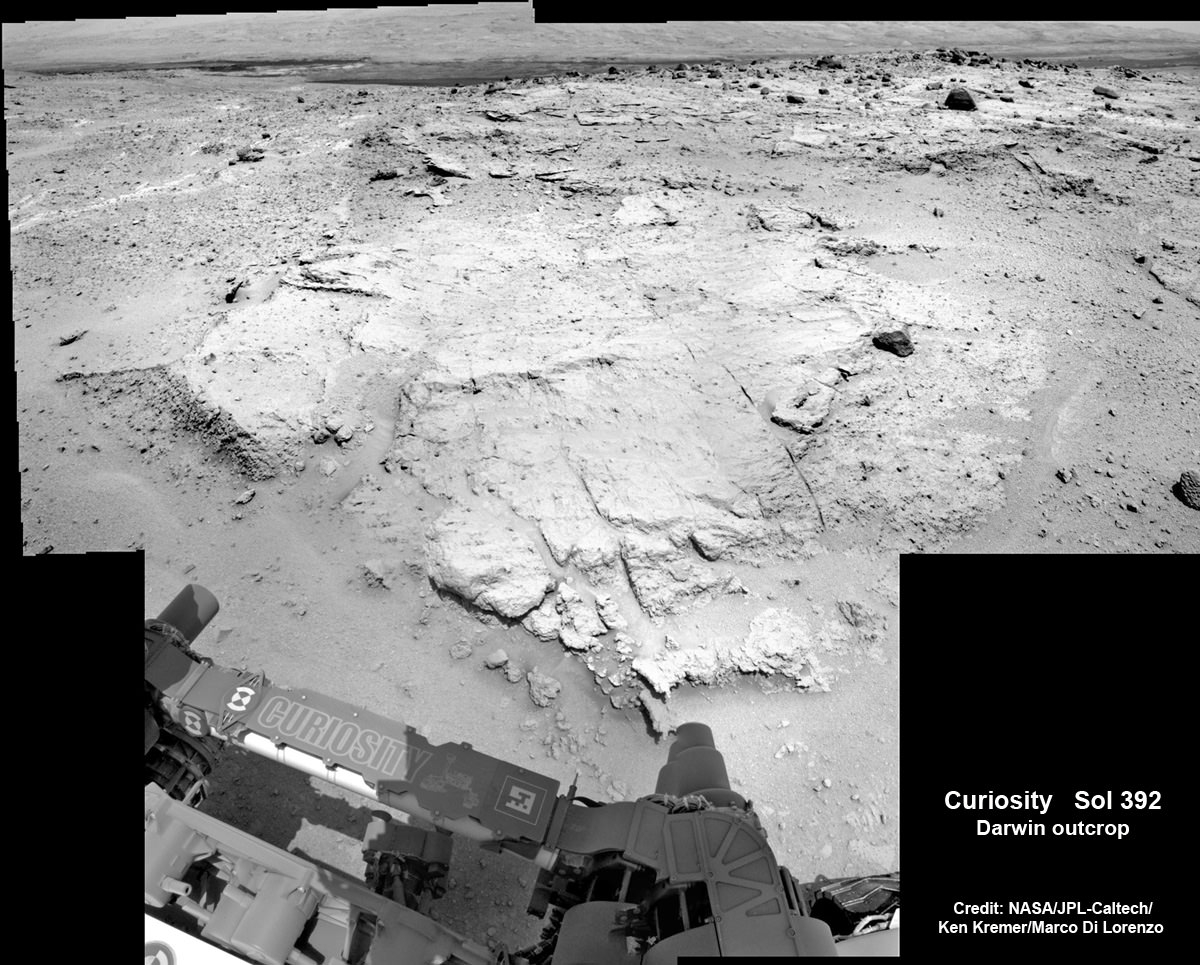
Evolving Excitement Over ‘Darwin’ Rock Outcrop at ‘Waypoint 1’. For at least a couple of days, the science team of NASA’s Mars rover Curiosity is focused on a full-bore science campaign at a tantalizing, rocky site informally called “Darwin.” This view of Darwin was taken with the Mast Camera (Mastcam) on Sol 390 (Sept. 10, 2013). Credit: NASA/JPL-Caltech/Malin Space Science Systems
The scientists goal is to compare the floor of Gale Crater to the sedimentary layers of 3 mile high (5 kilometer high) Mount Sharp.
Waypoint 1 is just over 1 mile along the approximately 5.3-mile (8.6-kilometer) route from ‘Glenelg’ to the entry point at the base of Mount Sharp.
Curiosity spent over six months investigating the ‘Yellowknife Bay’ area inside Glenelg before departing on July 4, 2013.
What’s the origin of Darwin’s name?
“Darwin comes from a list of 100 names the team put together to designate rocks in the Mawson Quadrangle – Mawson is the name of a geologist who studied Antarctic geology,” Grotzinger told me.
“Recently we left the Yellowknife Quadrangle, so instead of naming rocks after geological formations in Canada’s north, we now turn to formation names of rocks from Antarctica, and Darwin is one of them.
“That will be the theme until we cross into the next quad,” Grotzinger explained.
Curiosity investigates the ‘Darwin’ rock outcrop up close after arriving for a short stay at ‘Waypoint 1’ on Sept 12 (Sol 392). This photo mosaic was assembled from navcam images taken on Sept 12, 2013. Credit: NASA/JPL-Caltech/Ken Kremer/Marco Di Lorenzo
Inside Yellowknife Bay, Curiosity conducted the historic first interplanetary drilling into Red Planet rocks and subsequent sample analysis with her duo of state of the art chemistry labs – SAM and CheMin.
At Yellowknife Bay, the 1 ton robot discovered a habitable environment containing the chemical ingredients that could sustain Martian microbes- thereby already accomplishing the primary goal of NASA’s flagship mission to Mars.
“We want to know how the rocks at Yellowknife Bay are related to what we’ll see at Mount Sharp,” Grotzinger elaborated in a NASA statement. “That’s what we intend to get from the waypoints between them. We’ll use them to stitch together a timeline — which layers are older, which are younger.”
On Sept. 5, Curiosity set a new one-day distance driving record for the longest drive yet by advancing 464 feet (141.5 meters) on her 13th month on the Red Planet.
As Curiosity neared Waypoint 1 she stopped at a rise called ‘Panorama Point’ on Sept. 7, spotted an outcrop of light toned streaks informally dubbed ‘Darwin and used her MastCam telephoto camera to collect high resolution imagery.
Curiosity will use her cameras, spectrometers and robotic arm for contact science and a “full bore science campaign” involving in-depth mineral and chemical composition analysis of Darwin and Waypoint 1 for the next few Sols, or Martian days, before resuming the trek to Mount Sharp that dominates the center of Gale Crater.
Curiosity Spies Mount Sharp – her primary destination. Curiosity will ascend mysterious Mount Sharp and investigate the sedimentary layers searching for clues to the history and habitability o the Red Planet of billions of years. This mosaic was assembled from Mastcam camera images taken on Sol 352 (Aug 2, 2013). Credit: NASA/JPL-Caltech/MSSS/ Marco Di Lorenzo/Ken Kremer
She will not conduct any drilling here or at the other waypoints, several team members have told me, unless there is some truly remarkable ‘Mars-shattering’ discovery.
Why is Curiosity now able to drive longer than ever before?
“We have put some new software – called autonav, or autonomous navigation – on the vehicle right after the conjunction period back in March 2013,” Jim Erickson, Curiosity Project Manager of NASA’s Jet Propulsion Laboratory (JPL), told Universe Today.
“This will increase our ability to drive. But how much it helps really depends on the terrain.”
And so far the terrain has cooperated.
“We are on a general heading of southwest to Mount Sharp,” said Erickson. See the NASA JPL route map.
“We have been going through various options of different planned routes.”
As of today (Sol 394), Curiosity remains healthy, has traveled 2.9 kilometers and snapped over 82,000 images.
If all goes well Curiosity could reach the entry point to Mount Sharp sometime during Spring 2014, at her current driving pace.
Learn more about Curiosity, Mars rovers,LADEE, Cygnus, Antares, MAVEN, Orion and more at Ken’s upcoming presentations
Sep 17/18: LADEE Lunar & Antares/Cygnus ISS Rocket Launches from Virginia”; Rodeway Inn, Chincoteague, VA
Oct 3: “Curiosity, MAVEN and the Search for Life on Mars – (3-D)”, STAR Astronomy Club, Brookdale Community College & Monmouth Museum, Lincroft, NJ, 8 PM
Oct 8: LADEE Lunar & Antares/Cygnus ISS Rocket Launches from Virginia”; Princeton University, Amateur Astronomers Assoc of Princeton (AAAP), Princeton, NJ, 8 PM
Curiosity Spies Mount Sharp - her primary destination. Curiosity will ascend mysterious Mount Sharp and investigate the sedimentary layers searching for clues to the history and habitability o the Red Planet of billions of years. This mosaic was assembled from Mastcam camera images taken on Sol 352 (Aug 2, 2013. Credit: NASA/JPL-Caltech/MSSS/ Marco Di Lorenzo/Ken Kremer
Curiosity Spies Mount Sharp – her primary destination. Curiosity will ascend mysterious Mount Sharp and investigate the sedimentary layers searching for clues to the history and habitability of the Red Planet over billions of years. But first she must safely trespass through the treacherous dark dunes fields. This mosaic was assembled from over 2 dozen Mastcam camera images taken on Sol 352 (Aug 2, 2013). Credit: NASA/JPL-Caltech/MSSS/ Marco Di Lorenzo/Ken Kremer
See the full mosaic below [/caption]
It’s never a dull moment for NASA’s Curiosity rover at T Plus 1 Year since touchdown on the Red Planet and T Minus 1 year to arriving at her primary target, the huge mountain overwhelming the center of the landing site inside Gale Crater.
Curiosity is literally and figuratively zooming in on stunningly beautiful and mysterious Mount Sharp (see our new mosaics above/below), her ultimate destination, while conducting ‘Science on the Go’ with her duo of chemistry labs – SAM and CheMin – and 8 other science instruments as she passes the 2 kilometer driving milestone today; Aug 20 !
“We are holding samples for drops to ChemMin and SAM when the science team is ready for it,” Jim Erickson, Curiosity Project Manager of NASA’s Jet Propulsion Laboratory (JPL), told Universe Today in an exclusive interview.
“Curiosity has landed in an ancient river or lake bed on Mars,” Jim Green, Director of NASA’s Planetary Science Division, told Universe Today.
So, those samples were altered by liquid Martian water – a prerequisite for life.
Curiosity Spies Mount Sharp – her primary destination. Curiosity will ascend mysterious Mount Sharp and investigate the sedimentary layers searching for clues to the history and habitability of the Red Planet over billions of years. But first she must safely trespass through the treacherous dark dunes fields. This mosaic was assembled from over 3 dozen Mastcam camera images taken on Sol 352 (Aug 2, 2013.
Credit: NASA/JPL-Caltech/MSSS/ Marco Di Lorenzo/Ken Kremer-kenkremer.com
In fact the car sized rover has saved samples from both the ‘John Klein’ and ‘Cumberland’ drill sites collected previously in the ‘Yellowknife Bay’ area for analysis by the miniaturized labs in the rovers belly -when the time is right.
“Curiosity has stored a Cumberland sample and still has a John Klein sample on board for future use,” Erickson explained.
And that time has now arrived!
“We have put a sample from the Cumberland drill hole into SAM for more isotopic measurements,” reported science team member John Bridges in a blog update on Sol 363, Aug. 14, 2013.
“The sample had been cached within the robotic arm’s turret.”
Curiosity is multitasking – conducting increasingly frequent traverses across the relatively smooth floor of Gale Crater while running research experiments for her science handlers back here on Earth.
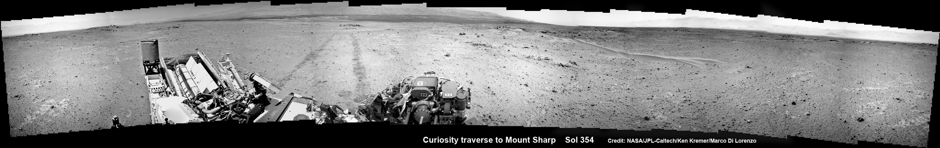
NASA’s Curiosity rover make tracks to Mount Sharp (at left) across the floor of Gale Crater. The rover paused to image the windblown ripple at right, below the hazy crater rim. The wheel tracks are about eight feet apart. This panoramic mosaic was assembled from a dozen navcam camera images taken on Sol 354 (Aug 4, 2013). Credit: NASA/JPL-Caltech/Ken Kremer/Marco Di Lorenzo
She’s captured stunning new views of Mount Sharp – rising 5 km (3 miles) high into the sky – and movies of Mars tiny pair of transiting moons while ingesting new portions of the drilled rock samples acquired earlier this year.
Here’s our video compilation of Phobos and Deimos transiting on Aug 1, 2013
Video caption: Transit of Phobos in front of Deimos, taken by MSL right MastCam imager on Sol 351 around 3:12 AM local time (Aug 1, 2013, 8:42 UTC); 16 original frames + 14 interpolated (5x speed-up). Credit: NASA/JPL-Caltech/MSSS/ Marco Di Lorenzo/Ken Kremer
The sample analysis is still in progress.
“The SAM data have not all been received yet,” wrote science team member Ken Herkenhoff in a blog update.
Earlier analysis of sample portions from both ‘John Klein’ and ‘Cumberland’ revealed that the Yellowknife Bay area on Mars possesses the key mineral ingredients proving that Red Planet was once habitable and could have sustained simple microbial life forms.
The scientists are seeking further evidence and have yet to detect organic molecules – which are the building blocks of life as we know it.
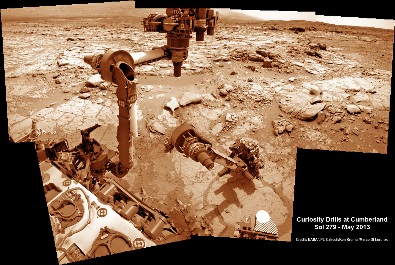
This time lapse mosaic shows Curiosity maneuvering her robotic arm to drill into her 2nd martian rock target named “Cumberland” to collect powdery Martian material on May 19, 2013 (Sol 279) for analysis by her onboard chemistry labs; SAM & Chemin- see 3 inlet ports lower left. The photomosaic was stitched from raw images captured by the navcam cameras on May 14 & May 19 (Sols 274 & 279). Credit: NASA/JPL-Caltech/Ken Kremer/Marco Di Lorenzo
Yellowknife Bay resembles a dried out river bed where liquid water once flowed eons ago when the Red Planet was far warmer and wetter than today.
As the 1 ton robot ascends Mount Sharp, she will examine sedimentary layers layed down on ancient Mars over hundreds of millions and perhaps billions of years of past history and habitability.
And just as the rover was celebrating 1 year on Mars on Aug 5/6, she found an intriguing sand dune on Sol 354. See our mosaic
“The rover paused to take images of its tracks after crossing a windblown ripple,” Herkenhoff reported.
As the six wheeled rover approaches Mount Sharp over the next year, she will eventually encounter increasing treacherous dunes that she must cross before beginning her mountain climbing foray.
As of today, Sol 369 (Aug. 20) Curiosity has broken through the 2 kilometer driving mark with a new 70 meter drive, snapped over 75,000 images and fired over 75,000 laser shots.
Mount Sharp is about 8 kilometers (5 miles) distant as the Martian crow flies.
How long will the journey to Mount Sharp require?
“Perhaps about a year,” Erickson told me. “We are trying to make that significantly faster by bringing autonav [autonomous navigation software] online.”
“That will help. But how much it helps really depends on the terrain.”
So far so good.
Meanwhile NASA’s next Mars orbiter called MAVEN (for Mars Atmosphere and Volatile Evolution), recently arrived at the Kennedy Space Center after a cross country flight.
Kennedy technicians are completing assembly and check out preparations for MAVEN’s blastoff to the Red Planet on Nov. 18 from Florida atop an Atlas V rocket similar to the one that launched Curiosity nearly 2 years ago.
And I’ll be at Kennedy to report up close on MAVEN’s launch.
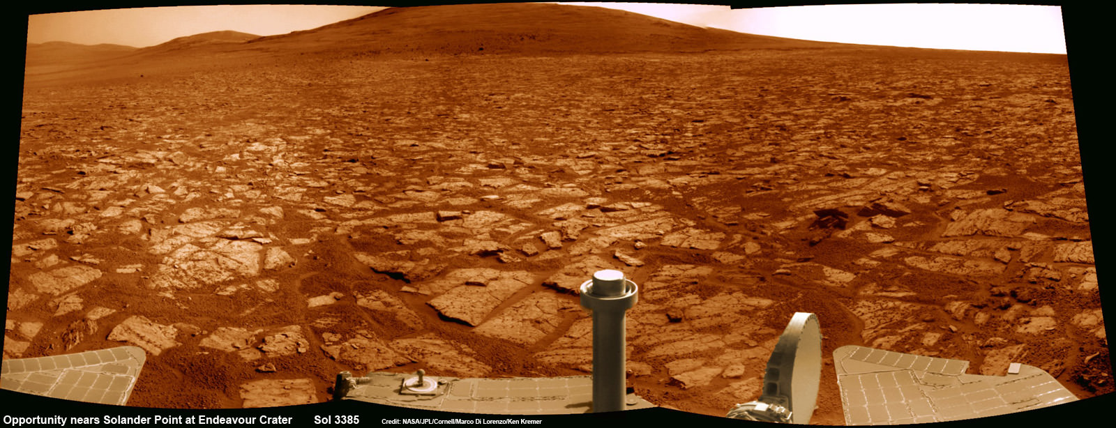
Opportunity rover’s 1st mountain climbing goal is dead ahead in this up close view of Solander Point along the eroded rim of Endeavour Crater. Opportunity will soon ascend the mountain in search of minerals signatures indicative of a past Martian habitable environment. This navcam panoramic mosaic was assembled from raw images taken on Sol 3385 (Aug 2, 2013). Credit: NASA/JPL/Cornell/Marco Di Lorenzo/Ken Kremer (kenkremer.com)
Opportunity rover’s 1st mountain climbing goal is dead ahead in this up close view of Solander Point at Endeavour Crater. Opportunity will ascend the mountain looking for clues indicative of a Martian habitable environment. This navcam panoramic mosaic was assembled from raw images taken on Sol 3385 (Aug 2, 2013).
Credit: NASA/JPL/Cornell/Marco Di Lorenzo/Ken Kremer (kenkremer.com)[/caption]
NASA’s most powerful Mars orbiter has been given the green light today (Aug. 5) to capture new high resolution spectral scans that are absolutely crucial for directing the long lived Opportunity rover’s hunt for signatures of habitability atop the intriguing mountain she will soon ascend.
In a plan only recently approved by NASA, engineers are aiming the CRISM mineral mapping spectrometer aboard the Mars Reconnaissance Orbiter (MRO) circling overhead to collect high resolution survey scans of Solander Point – Opportunity’s 1st mountain climbing goal along the rim of huge Endeavour Crater.
“New CRISM observations centered over Solander Point will be acquired on Aug. 5, 2013,” Ray Arvidson told Universe Today exclusively. Arvidson is the mission’s deputy principal scientific investigator from Washington University in St. Louis, Mo.
NASA’s decade old rover Opportunity is about to make ‘landfall’ at the base of Solander Point, the Martian mountain she will scale in search of the chemical ingredients that could sustain Martian microbes.
So the new spectral data can’t come back to Earth soon enough.
Currently, the science team lacks the same quality of high resolution CRISM data from Solander Point that they had at a prior stop at Cape York. And that data was crucial because it allowed the rover to be precisely targeted – and thereby discover a habitable zone, Arvidson told me.
“CRISM collected lots of overlapping measurements at Cape York to sharpen the image resolution to 5 meters per pixel to find the phyllosilicate smectite [clay minerals] signatures at Matejivic Hill on Cape York.”
“We don’t have that at Solander Point. We only have 18 meters per pixel data. And at that resolution you can’t tell if the phyllosilicate smectite [clay minerals] outcrops are present.”
Today’s new survey from Mars orbit will vastly improve the spectral resolution – from 18 meters per pixel down to 5 meters per pixel.
“5 meter per pixel CRISM resolution is expected in the along-track direction over Solander Point by commanding the gimbaled optical system to oversample that much,” Arvidson explained.
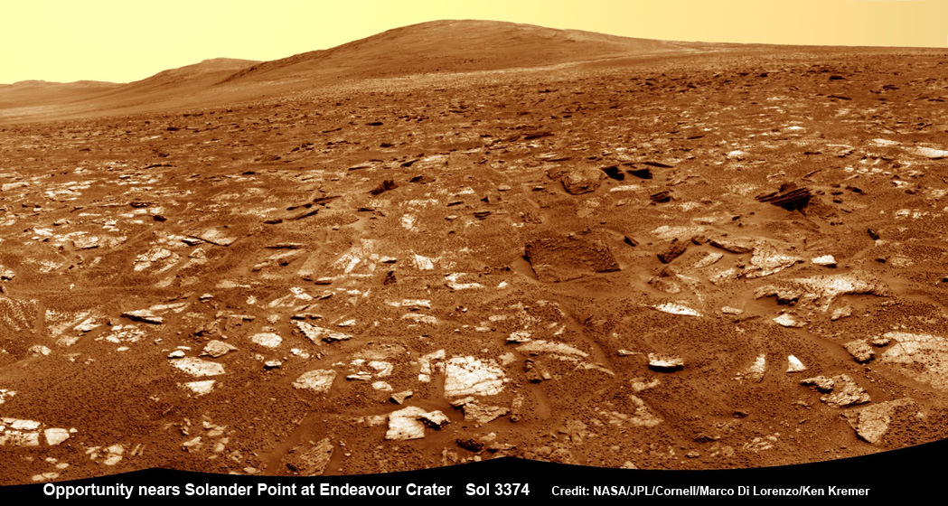
Opportunity rover’s view from very near the foothills of Solander Point looking along the rim and vast expanse of Endeavour Crater. Solander Point is the 1st Martian Mountain NASA’s Opportunity will climb and the rovers next destination. Solander Point may harbor clay minerals indicative of a past Martian habitable environment. This navcam mosaic was assembled from raw images taken on Sol 3374 (July 21, 2013). Credit: NASA/JPL/Cornell/Marco Di Lorenzo/Ken Kremer (kenkremer.com)
The new CRISM spectral survey from Mars is essential to enable the science team to carefully study the alien, unexplored terrain in detail and locate the clay minerals and other water bearing minerals, even before the rover arrives.
Clay minerals form in neutral pH water conducive to life.
Opportunity would then be commanded to drive to preselected sites to conduct “ground truth” forays at Solander.
That’s just like was done at Cape York and the “Esperance” rock loaded with clay minerals that turned into one of the “Top 5 discoveries of the mission” according to Arvidson and Steve Squyres, Opportunity’s Science Principal Investigator of Cornell.
But it took some cajoling and inter team negotiations to convince everyone to move forward with the special but crucial CRISM imaging plan.
Since MRO is getting on in age – it launched in 2005 – NASA and the spacecraft managers have to carefully consider special requests such as this one which involves slewing the MRO spacecraft instruments and therefore entails some health risks to the vehicle.
“CRISM has been operating at Mars since 2006 and sometimes the optics on a gimble have actuators that get stuck a little bit and don’t sweep as fully as planned.”
Nevertheless, Arvidson told me a few weeks ago he was hopeful to get approval.
“I suspect I can talk the team into it.”
And eventually he did! And informed me for the readers of Universe Today.
The fact that the Opportunity scientists already scored a ‘Science Home Run’ with their prior CRISM targeting request at Cape York certainly aided their cause immensely.
The new approved CRISM measurements due to be captured today will give Opportunity the best chance to be targeted to the most promising mineral outcrops, and as quickly as possible.
“With the coordinated observations from CRISM and Opportunity we will go into Solander Point a lot smarter!”
“And we’ll have a pretty good idea of what to look for and where,” Arvidson told me.
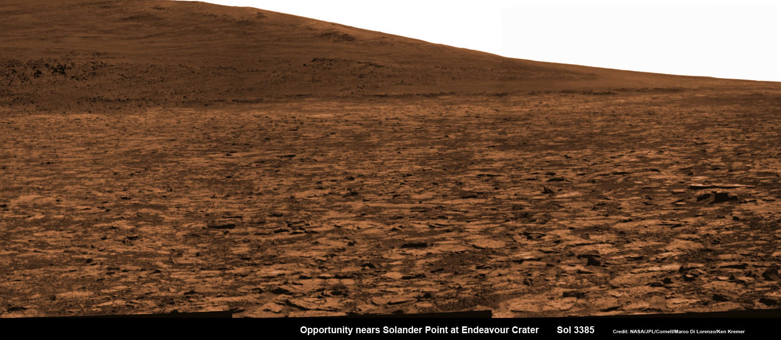
Opportunity snap up close view of the base of Solander Point and mountain slopes she will ascend soon. This hi res pancam camera mosaic was assembled from raw images taken on Sol 3385 (Aug 2, 2013). Credit: NASA/JPL/Cornell/ASU/Marco Di Lorenzo/Ken Kremer (kenkremer.com)
Today marks Opportunity’s 3389th Sol or Martian day roving Mars. Merely 90 days were expected!
Having completed her investigation of the rocky crater plains, the rover continues to drive south.
Any day now Opportunity will drive onto the Bench surrounding Solander and start a new phase of the mission.
Since she basically arrived at Solander with plenty of power and ahead of schedule prior to the onset of the 6th Martian winter, the robot has some spare time to investigate the foothills before ascending the north facing slopes.
“We will be examining the bench and then working our way counterclockwise to reach the steep slopes associated with the Noachian outcrops that are part of the Endeavour rim,” Arvidson said.
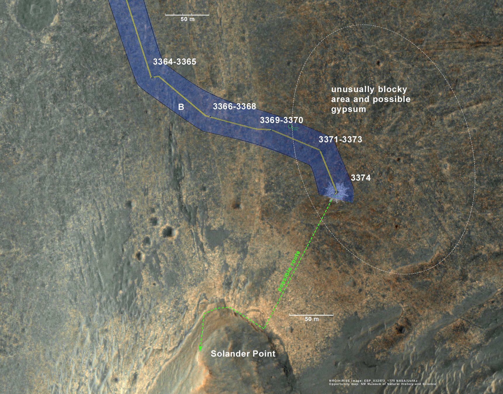
Ken Kremer Opportunity rover location in the latest MRO/HiRISE color image. The green line shows more or less the route we hope to take to the base of Solander point. Since it is only a couple of hundred meters away, we could be there is a couple of drives. Maybe by the end of next week. The label say “3374” but this is also roughly the location through 3379. Credit: NASA/JPL/Larry Crumpler
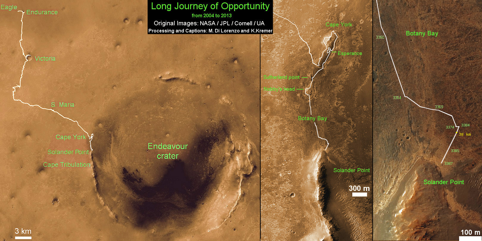
Traverse Map for NASA’s Opportunity rover from 2004 to 2013
This map shows the entire path the rover has driven during more than 9 years and over 3387 Sols, or Martian days, since landing inside Eagle Crater on Jan 24, 2004 to current location near foothills of Solander Point at the western rim of Endeavour Crater. Opportunity discovered clay minerals at Esperance – indicative of a habitable zone. Credit: NASA/JPL/Cornell/ASU/Marco Di Lorenzo/Ken Kremer