8 Years of Spirit on Mars – Pushing as Hard as We Can and Beyond !

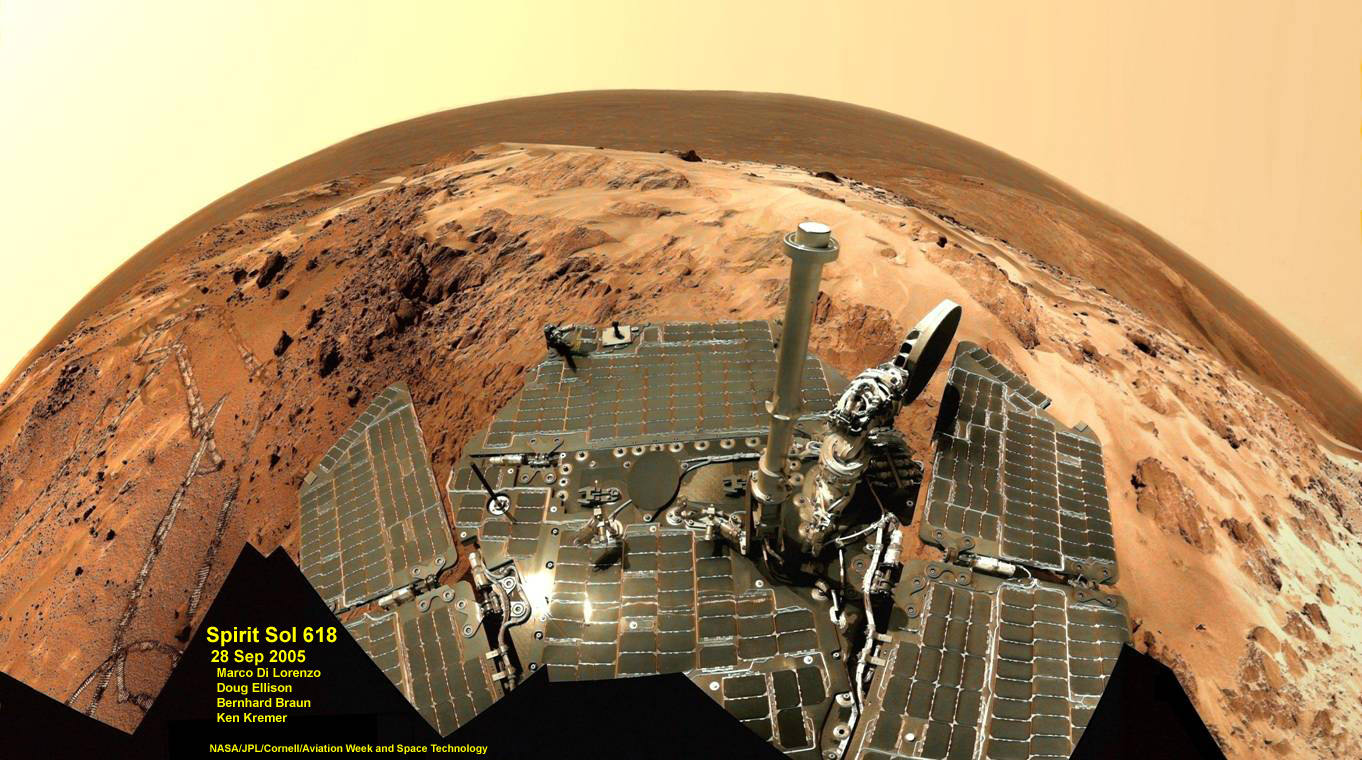
Spirit Mars rover - view from Husband Hill summit. Spirit snapped this view self portrait from the summit of Husband Hill inside Gusev crater on Sol 618 on 28 September 2005. The rovers were never designed or intended to climb mountains. It took more than 1 year for Spirit to scale the Martian mountain. This image was created by an international team of astronomy enthusiasts and appeared on the cover of the 14 November 2005 issue of Aviation Week & Space Technology magazine and the April 2006 issue of Spaceflight magazine. Also selected by Astronomy Picture of the Day (APOD) on 28 November 2005. Credit: Marco Di Lorenzo, Douglas Ellison, Bernhard Braun and Kenneth Kremer. NASA/JPL/Cornell/Aviation Week & Space Technology

[/caption]

January 2012 marks the 8th anniversary since of the daring landing’s of “Spirit” and “Opportunity”NASA’s now legendary twin Mars Exploration Rovers (MER), on opposite sides of the Red Planet in January 2004. They proved that early Mars was warm and wet – a key finding in the search for habitats conducive to life beyond Earth.

I asked the leaders of the MER team to share some thoughts celebrating this mind-boggling milestone of “8 Years on Mars” and the legacy of the rovers for the readers of Universe Today. This story focuses on Spirit, first of the trailblazing twin robots, which touched down inside Gusev Crater on Jan. 3, 2004. Opportunity set down three weeks later on the smooth hematite plains of Meridiani Planum.

“Every Sol is a gift. We push the rovers as hard as we can,” Prof. Steve Squyres informed Universe Today for this article commemorating Spirit’s landing. Squyres, of Cornell University, is the Scientific Principal Investigator for the MER mission.

“I seriously thought both Spirit and Opportunity would be finished by the summer of 2004,” Ray Arvidson told Universe Today. Arvidson, of Washington University in St. Louis, is the deputy principal investigator for the MER rovers.

'Calypso' Panorama of Spirit's View from 'Troy'
This full-circle view from the panoramic camera (Pancam) on NASA's Mars Exploration Rover Spirit shows the terrain surrounding the location called "Troy," where Spirit became embedded in soft soil during the spring of 2009. The hundreds of images combined into this view were taken beginning on the 1,906th Martian day (or sol) of Spirit's mission on Mars (May 14, 2009) and ending on Sol 1943 (June 20, 2009). Credit: NASA/JPL-Caltech/Cornell University
click to enlarge

Spirit endured for more than six years and Opportunity is still roving Mars today !

The dynamic robo duo were expected to last a mere three months, or 90 Martian days (sols). In reality, both robots enormously exceeded expectations and accumulated a vast bonus time of exploration and discovery in numerous extended mission phases.

Spirit survived three harsh Martian winters and only succumbed to the Antarctic-like temperatures when she unexpectedly became mired in an unseen sand trap driving beside an ancient volcanic feature named ‘Home Plate’ that prevented the solar arrays from generating life giving power to safeguard critical electronic and computor components.

Spirit was heading towards another pair of volcanic objects named von Braun and Goddard and came within just a few hundred feet when she died.

Everest Panorama from Husband Hill summit
It took Spirit three days, sols 620 to 622 (Oct. 1 to Oct. 3, 2005), to acquire all the images combined into this mosaic, called the "Everest Panorama". Credit: NASA/JPL-Caltech/Cornell University
Click to enlarge

“I never thought that we would still be planning sequences for Opportunity today and that we only lost Spirit because of her limited mobility and bad luck of breaking through crusty soil to get bogged down in loose sands,” said Arvidson

By the time of her last dispatch from Mars in March 2010, Spirit had triumphantly traversed the red planets terrain for more than six years of elapsed mission time – some 25 times beyond the three month “warranty” proclaimed by NASA as the mission began back in January 2004.
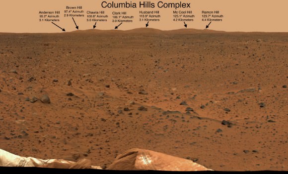
The "Columbia Hills" in Gusev Crater on Mars
Husband Hill is 3.1 kilometers distant. Spirit took this mosaic of images with the panoramic camera at the beginning of February, 2004, less than a month after landing on Mars. Image credit: NASA/JPL-Caltech/Cornell

“I am feeling pretty good as the MER rover anniversaries approach in that Spirit had an excellent run, helping us understand without a doubt that early Mars had magmatic and volcanic activity that was “wet”, Arvidson explained.

“Magmas interacted with ground water to produce explosive eruptions – at Home Plate, Goddard, von Braun – with volcanic constructs replete with steam vents and perhaps hydrothermal pools.”

Altogether, the six wheeled Spirit drove over 4.8 miles (7.7 kilometers) and the cameras snapped over 128,000 images. NASA hoped the rovers would drive about a quarter mile during the planned 90 Sol mission.

“Milestones like 8 years on Mars always make me look forward rather than looking back,” Squyres told me.
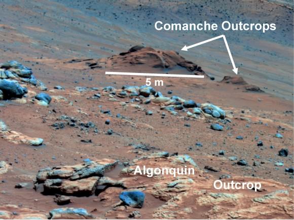
Carbonate-Containing Martian Rocks discovered by Spirit Mars Rover
Spirit collected data in late 2005 which confirmed that the Comanche outcrop contains magnesium iron carbonate, a mineral indicating the past environment was wet and non-acidic, possibly favorable to life. This view was captured during Sol 689 on Mars (Dec. 11, 2005). The find at Comanche is the first unambiguous evidence from either Spirit or Opportunity for a past Martian environment that may have been more favorable to life than the wet but acidic conditions indicated by the rovers' earlier finds. Credit: NASA/JPL-Caltech/Cornell University

Spirit became the first robotic emissary from humanity to climb a mountain beyond Earth, namely Husband Hill, a task for which she was not designed.

“No one expected the rovers to last so long,” said Rob Manning to Universe Today. Manning, of NASA’s Jet Propulsion laboratory, Pasadena, CA. was the Mars Rover Spacecraft System Engineering team lead for Entry, Descent and Landing (EDL)

“Spirit surmounted many obstacles, including summiting a formidable hill her designers never intended her to attempt.”

“Spirit, her designers, her builders, her testers, her handlers and I have a lot to be thankful for,” Manning told me.

After departing the Gusev crater landing pad, Spirit traversed over 2 miles to reach Husband Hill. In order to scale the hill, the team had to create a driving plan from scratch with no playbook because no one ever figured that such a mouthwatering opportunity to be offered.
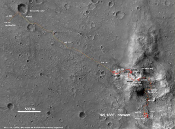
Spirit Rover traverse map from Gusev Crater landing site to Home Plate: 2004 to 2011

It took over a year to ascend to the hill’s summit. But the team was richly rewarded with a science bonanza of evidence for flowing liquid water on ancient Mars.

Spirit then descended down the other side of the hill to reach the feature dubbed Home Plate where she now rests and where she found extensive evidence of deposits of nearly pure silica, explosive volcanism and hot springs all indicative of water on Mars billions of years ago.

“Spirit’s big scientific accomplishments are the silica deposits at Home Plate, the carbonates at Comanche, and all the evidence for hydrothermal systems and explosive volcanism, Squyres explained. “ What we’ve learned is that early Mars at Spirit’s site was a hot, violent place, with hot springs, steam vents, and volcanic explosions. It was extraordinarily different from the Mars of today.”

“We’ve still got a lot of exploring to do [with Opportunity], but we’re doing it with a vehicle that was designed for a 90-sol mission,” Squyres concluded. “That means that ever sol is a gift at this point, and we have to push the rover and ourselves as hard as we can.”

NASA concluded the last attempt to communicate with Spirit in a transmission on May 25, 2011.

Spirit Rover traverse map from Husband Hill to resting place at Home Plate: 2004 to 2011
The Last View Ever from Spirit rover on Mars
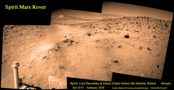
Spirit’s last panorama from Gusev Crater was taken during February 2010 before her death from extremely low temperatures during her 4th Martian winter. Spirit was just 500 feet from her next science target - dubbed Von Braun – at center, with Columbia Hills as backdrop.
Mosaic Credit: Marco De Lorenzo/ Kenneth Kremer/ NASA/JPL/Cornell University
Mosaic featured on Astronomy Picture of the Day (APOD) on 30 May 2011 - http://apod.nasa.gov/apod/ap110530.html

Meanwhile, the Curiosity Mars Science Lab rover, NASA’s next Red Planet explorer, continues her interplanetary journey on course for a 6 August 2012 landing at Gale Crater.

Read continuing features about the Mars Rovers, Curiosity and GRAIL by Ken Kremer here:
Two new Moons join the Moon – GRAIL Twins Achieve New Year’s Orbits
2011: Top Stories from the Best Year Ever for NASA Planetary Science!
Opportunity Discovers Most Powerful Evidence Yet for Martian Liquid Water
Curiosity Starts First Science on Mars Sojurn – How Lethal is Space Radiation to Life’s Survival

Jan 11: Free Lecture by Ken Kremer at the Franklin Institute, Philadelphia, PA at 8 PM for the Rittenhouse Astronomical Society. Topic: Mars & Vesta in 3 D – Plus Search for Life & GRAIL

Beam Me Up, Obama: Conspiracy Theory Claims President Teleported to Mars

Was the 44th President of the United States a time-traveling teenage Mars explorer?

[/caption]

Forget 2012 prophecies, Mayan calendars and lurking planets that go only by the name “X”… there’s an even kookier conspiracy theory in town, and it has to do with our nation’s fearless leader and his teenage teleportation adventures on Mars.

Yes, you read that right.

It seems that two government employees and self-professed time-travelers – er, “chrononauts” – Andrew D. Basiago and William Stillings have come forth and named President Obama as one of their own, along with the current head of DARPA, Regina Dugan.

(DARPA, if you don’t know, is the agency responsible for keeping U.S. defense up-t0-date with advancements in technology. Begun as a response to the Sputnik program in the late 50s, DARPA finds ways to integrate cutting-edge tech developments into stuff the military might want.)

Basiago, a Washington state lawyer, says that he was part of a time travel program developed by DARPA in the 1970s code-named Project Pegasus. He and Stillings claim that both Obama and Dugan were in their “Mars training class” at California’s College of the Siskiyous in 1980, part of a group of 10 young adults chosen to travel to Mars via a top-secret teleportation “jump room”.

They also claim that the then-19-year-old Barack Obama went by the name “Barry Soetero”.

But wait, there’s more.

"I'll beam ya down Mister President but I'll have to see your birth certificate first." (Photo via startrek.com)

The two former chrononauts also said that they encountered the future president at secret U.S. bases on Mars, which he is said to have visited twice between the years 1981 and 1983. On one instance Basiago said he even exchanged words with Ob – uh, Soetero – en route to the “jump room” while on Mars.

“We’re here,” Basiago claims the young president-to-be said to him.

And the supposed reason for the secret teen task force’s Red Planet expedition? To “acclimate Martian humanoids and animals to their presence,” according to Basiago.

You know, to make good with the locals so there’d be no trouble when setting up camp.

White House officials have denied all allegations of the President’s Martian travels, or the existence of a Mars training class. But, of course, they would. 

And you thought the whole birther thing was a bit extreme? Wake up sheeple, this is some real crazy here. Chrononaut style.

Read more on Wired.com’s “Danger Room”.


Top image assembled by J. Major from NASA and Hubble images and a campaign photo of President Obama. Star Trek image from www.startrek.com. © 2010 CBS Studios Inc., All Rights Reserved.

2011: Top Stories from the Best Year Ever for NASA Planetary Science!

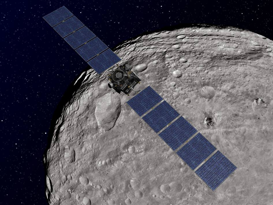
Dawn Orbiting Vesta. NASA's Dawn spacecraft achieved orbit at the giant asteroid Vesta in July 2011. The depiction of Vesta is based on images obtained by Dawn's framing cameras. Dawn is an international collaboration of the US, Germany and Italy. Credit: NASA/JPL-Caltech

[/caption]

A year ago, 2011 was proclaimed as the “Year of the Solar System” by NASA’s Planetary Science division. And what a year of excitement it was indeed for the planetary science community, amateur astronomers and the general public alike !

NASA successfully delivered astounding results on all fronts – On the Story of How We Came to Be.

“2011 was definitely the best year ever for NASA Planetary Science!” said Jim Green in an exclusive interview with Universe Today. Green is the Director of Planetary Science for the Science Mission Directorate at NASA HQ. “The Search for Life is a significant priority for NASA.”

This past year was without doubt simply breathtaking in scope in terms of new missions, new discoveries and extraordinary technical achievements. The comprehensive list of celestial targets investigated in 2011 spanned virtually every type of object in our solar system – from the innermost planet to the outermost reaches nearly touching interplanetary space.

There was even a stunningly evocative picture showing “All of Humanity” – especially appropriate now in this Holiday season !

You and all of Humanity are here !
-- Earth & Moon Portrait by Juno from 6 Million miles away --
First Photo transmitted from Jupiter Bound Juno shows Earth (on the left) and the Moon (on the right). Taken on Aug. 26, 2011 when spacecraft was about 6 million miles (9.66 million kilometers) away from Earth. Credit: NASA/JPL-Caltech

Three brand new missions were launched and ongoing missions orbited a planet and an asteroid and flew past a comet.

“NASA has never had the pace of so many planetary launches in such a short time,” said Green.

And three missions here were awarded ‘Best of 2011’ for innovation !

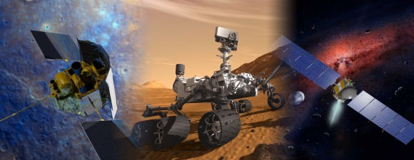
Mars Science Laboratory (MSL), Dawn and MESSENGER named “Best of What’s New” in 2011 by Popular Science magazine. 3 NASA Planetary Science missions received the innovation award for 2011 from Popular Science magazine. Artist concept shows mosaic of MESSENGER, Mars Science Laboratory and Dawn missions. Credit: NASA/JPL-Caltech

Here’s the Top NASA Planetary Science Stories of 2011 – ‘The Year of the Solar System’ – in chronological order

1. Stardust-NExT Fly By of Comet Tempel 1

Starting from the first moments of 2011 at the dawn of Jan. 1, hopes were already running high for planetary scientists and engineers busily engaged in setting up a romantic celestial date in space between a volatile icy comet and an aging, thrusting probe on Valentine’s Day.

The comet chasing Stardust-Next spacecraft successfully zoomed past Comet Tempel 1 on Feb. 14 at 10.9 km/sec (24,000 MPH) after flying over 6 Billion kilometers (3.5 Billion mi).

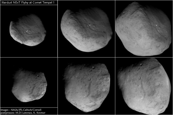
6 Views of Comet Tempel 1 and Deep Impact crater during Stardust-NExT flyby on Feb. 14, 2011
Arrows show location of man-made crater created in 2005 by NASA’s prior Deep Impact comet mission and newly imaged as Stardust-NExT zoomed past comet in 2011. The images progress in time during closest approach to comet beginning at upper left and moving clockwise to lower left. Credit: NASA/JPL-Caltech/University of Maryland. Post process and annotations by Marco Di Lorenzo & Kenneth Kremer

The craft approached within 178 km (111mi) and snapped 72 astonishingly detailed high resolution science images over barely 8 minutes. It also fulfilled the teams highest hopes by photographing the human-made crater created on Tempel 1 in 2005 by a cosmic collision with a penetrator hurled by NASA’s Deep Impact spacecraft. The probe previously flew by Comet Wild 2 in 2004 and returned cometary coma particles to Earth in 2006

Tempel 1 is the first comet to be visited by two spaceships from Earth and provided the first-ever opportunity to compare observations on two successive passages around the Sun.

Don Brownlee, the original Principal Investigator, summarized the results for Universe Today; “A great bonus of the mission was the ability to flyby two comets and take images and measurements. The wonderfully successful flyby of Comet Tempel 1 was a great cap to the 12 year mission and provided a great deal of new information to study the diversity among comets.”

“The new images of Tempel showed features that form a link between seemingly disparate surface features of the 4 comets imaged by spacecraft. Combining data on the same comet from the Deep Impact and Stardust missions has provided important new insights in to how comet surfaces evolve over time and how they release gas and dust into space”.

2. MESSENGER at Mercury

On March 18, the Mercury Surface, Space Environment, Geochemistry, and Ranging, or MESSENGER, spacecraft became the first spacecraft inserted into orbit around Mercury, the innermost planet.

So far MESSENGER has completed 1 solar day – 176 Earth days- circling above Mercury. The probe has collected a treasure trove of new data from the seven instruments onboard yielding a scientific bonanza; these include global imagery of most of the surface, measurements of the planet’s surface chemical composition, topographic evidence for significant amounts of water ice, magnetic field and interactions with the solar wind.

“MESSENGER discovered that Mercury has an enormous core, larger than Earth’s. We are trying to understand why that is and why Mercury’s density is similar to Earth’s,” Jim Green explained to Universe Today.

The First Solar Day
After its first Mercury solar day (176 Earth days) in orbit, MESSENGER has nearly completed two of its main global imaging campaigns: a monochrome map at 250 m/pixel and an eight-color, 1-km/pixel color map. Small gaps will be filled in during the next solar day. Credit: NASA/Johns Hopkins University Applied Physics Laboratory/Carnegie Institution of Washington

“The primary mission lasts 2 solar days, equivalent to 4 Mercury years.”

“NASA has granted a 1 year mission extension, for a total of 8 Mercury years. This will allow the team to understand the environment at Mercury during Solar Maximum for the first time. All prior spacecraft observations were closer to solar minimum,” said Green.

MESSENGER was launched in 2004 and the goal is to produce the first global scientific observations of Mercury and piece together the puzzle of how Mercury fits in with the origin and evolution of our solar system.

NASA’s Mariner 10 was the only previous robotic probe to explore Mercury, during three flyby’s back in the mid-1970’s early in the space age.

3. Dawn Asteroid Orbiter

The Dawn spacecraft achieved orbit around the giant asteroid Vesta in July 2011 after a four year interplanetary cruise and began transmitting the history making first ever close-up observations of the mysteriously diverse and alien world that is nothing short of a ‘Space Spectacular’.

“We do not have a good analog to Vesta anywhere else in the Solar System,” Chris Russell said to Universe Today. Russell, from UCLA, is the scientific Principal Investigator for Dawn.

Before Dawn, Vesta was just another fuzzy blob in the most powerful telescopes. Dawn has completely unveiled Vesta as a remarkably dichotomous, heavily battered and pockmarked world that’s littered with thousands of craters, mountains and landslides and ringed by mystifying grooves and troughs. It will unlock details about the elemental abundances, chemical composition and interior structure of this marvelously intriguing body.

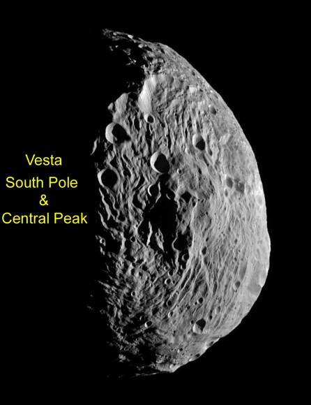
Cataclysmic collisions eons ago excavated Vesta so it lacks a south pole. Dawn discovered that what unexpectedly remains is an enormous mountain some 16 miles (25 kilometers) high, twice the height of Mt. Everest.

Dawn is now about midway through its 1 year mission at Vesta which ends in July 2012 with a departure for Ceres, the largest asteroid. So far the framing cameras have snapped more than 10,000 never-before-seen images.

“What can be more exciting than to explore an alien world that until recently was virtually unknown!. ” Dr. Marc Rayman said to Universe Today. Rayman is Dawn’s Chief Engineer from NASA’s Jet Propulsion Lab (JPL) in Pasadena, Calif.

“Dawn is NASA at its best: ambitious, exciting, innovative, and productive.”

4. Juno Jupiter Orbiter

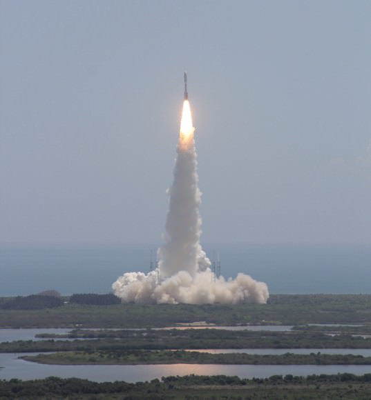
The solar powered Juno spacecraft was launched on Aug. 5 at Cape Canaveral Air Force Station in Florida, to embark on a five year, 2.8 billion kilometer (1.7 Billion mi) trek to Jupiter, our solar system’s largest planet. It was the first of three NASA planetary science liftoffs scheduled in 2011.

Juno Jupiter Orbiter soars skyward to Jupiter on Aug. 5, 2011 from Cape Canaveral Air Force Station, Florida. Credit: Ken Kremer

Juno’s goal is to map to the depths of the planets interior and elucidate the ingredients of Jupiter’s genesis hidden deep inside. These measurements will help answer how Jupiter’s birth and evolution applies to the formation of the other eight planets.

The 4 ton spacecraft will arrive at the gas giant in July 2016 and fire its braking rockets to go into a polar orbit and circle the planet 33 times over about one year.

The suite of nine instruments will scan the gas giant to find out more about the planets origins, interior structure and atmosphere, measure the amount of water and ammonia, observe the aurora, map the intense magnetic field and search for the existence of a solid planetary core.

“Jupiter is the Rosetta Stone of our solar system,” said Scott Bolton, Juno’s principal investigator from the Southwest Research Institute in San Antonio. “It is by far the oldest planet, contains more material than all the other planets, asteroids and comets combined and carries deep inside it the story of not only the solar system but of us. Juno is going there as our emissary — to interpret what Jupiter has to say.”

5. Opportunity reaches Endeavour Crater on Mars

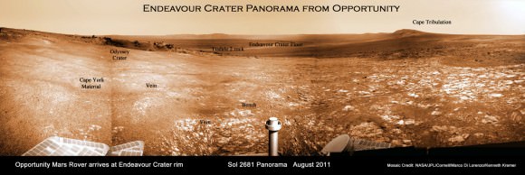
The long lived Opportunity rover finally arrived at the rim of the vast 14 mile (22 kilometer) wide Endeavour Crater in mid-August 2011 following an epic three year trek across treacherous dune fields – a feat once thought unimaginable. All told, Opportunity has driven more than 34 km ( 21 mi) since landing on the Red Planet way back in 2004 for a mere 90 sol mission.

Endeavour Crater Panorama from Opportunity Mars Rover in August 2011
Opportunity arrived at the rim of Endeavour on Sol 2681, August 9, 2011 after a three year trek. The robot photographed segments of the huge craters eroded rim in this panoramic vista. Endeavour Crater is 14 miles (22 kilometers) in diameter. Mosaic Credit: NASA/JPL/Cornell/Marco Di Lorenzo/Kenneth Kremer

In November, the rover discovered the most scientifically compelling evidence yet for the flow of liquid water on ancient Mars in the form of a water related mineral vein at a spot dubbed “Homestake” along an eroded ridge of Endeavour’s rim.

Read my story about the Homestake discovery here, along with our panoramic mosaic showing the location – created by Ken Kremer and Marco Di Lorenzo and published by Astronomy Picture of the Day (APOD) on 12 Dec. 2011.

Watch for my upcoming story detailing Opportunity’s accomplishments in 2011.

6. GRAIL Moon Mappers
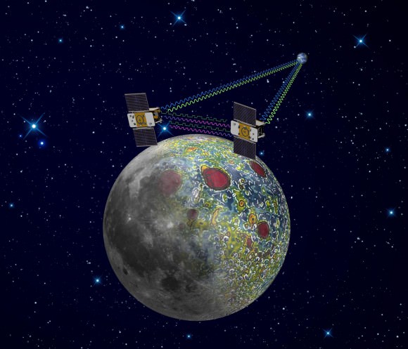
The Gravity Recovery and Interior Laboratory, or GRAIL mission is comprised of twin spacecraft tasked to map the moon’s gravity and study the structure of the lunar interior from crust to core.

Twin GRAIL Probes GO for Lunar Orbit Insertion on New Year’s Eve and New Year’s Day
GRAIL spacecraft will map the moon's gravity field and interior composition. Credit: NASA/JPL-Caltech

The dynamic duo lifted off from Cape Canaveral on September 10, 2011 atop the last Delta II rocket that will likely soar to space from Florida. After a three month voyage of more than 2.5 million miles (4 million kilometers) since blastoff, the two mirror image GRAIL spacecraft dubbed Grail-A and GRAIL-B are sailing on a trajectory placing them on a course over the Moon’s south pole on New Year’s weekend.

Each spacecraft will fire the braking rockets for about 40 minutes for insertion into Lunar Orbit about 25 hours apart on New Year’s Eve and New Year’s Day.

Engineers will then gradually lower the satellites to a near-polar near-circular orbital altitude of about 34 miles (55 kilometers).

The spacecraft will fly in tandem and the 82 day science phase will begin in March 2012.

“GRAIL is a Journey to the Center of the Moon”, says Maria Zuber, GRAIL principal investigator from the Massachusetts Institute of Technology (MIT). “GRAIL will rewrite the book on the formation of the moon and the beginning of us.”

“By globally mapping the moon’s gravity field to high precision scientists can deduce information about the interior structure, density and composition of the lunar interior. We’ll evaluate whether there even is a solid or liquid core or a mixture and advance the understanding of the thermal evolution of the moon and the solar system,” explained co-investigator Sami Asmar to Universe Today. Asmar is from NASA’s Jet Propulsion Laboratory (JPL)

7. Curiosity Mars Rover

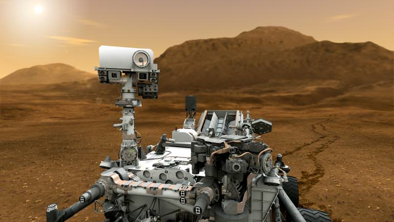
The Curiosity Mars Science Lab (MSL) rover soared skywards on Nov. 26, the last of 2011’s three planetary science missions. Curiosity is the newest, largest and most technologically sophisticated robotic surveyor that NASA has ever assembled.

“MSL packs the most bang for the buck yet sent to Mars.” John Grotzinger, the Mars Science Laboratory Project Scientist of the California Institute of Technology, told Universe Today.

The three meter long robot is the first astrobiology mission since the Viking landers in the 1970’s and specifically tasked to hunt for the ‘Ingredients of Life’ on Mars – the most Earth-like planet in our Solar System.


Video caption: Action packed animation depicts sequences of Curiosity departing Earth, the nail biting terror of the never before used entry, descent and landing on the Martian surface and then looking for signs of life at Gale Crater during her minimum two year expedition across hitherto unseen and unexplored Martian landscapes, mountains and craters. Credit: NASA

Curiosity will gather and analyze samples of Martian dirt in pursuit of the tell-tale signatures of life in the form of organic molecules – the carbon based building blocks of life as we know it.

NASA is targeting Curiosity to a pinpoint touch down inside the 154 km (96 mile) wide Gale Crater on Aug. 6, 2012. The crater exhibits exposures of phyllosilicates and other minerals that may have preserved evidence of ancient or extant Martian life and is dominated by a towering 3 mile (5 km) high mountain.

“10 science instruments are all aimed at a mountain whose stratigraphic layering records the major breakpoints in the history of Mars’ environments over likely hundreds of millions of years, including those that may have been habitable for life,” Grotzinger told me.

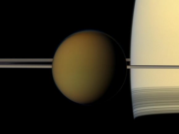
Titan Upfront
The colorful globe of Saturn's largest moon, Titan, passes in front of the planet and its rings in this true color snapshot from NASA's Cassini spacecraft. Credit: NASA/JPL-Caltech/Space Science Institute
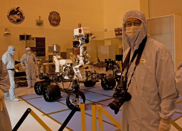
Curiosity Mars Science Laboratory Rover and Ken Kremer - inside the Cleanroom at the Kennedy Space Center. Last View of Curiosity just prior to folding and encapsulation for launch. Credit: Ken Kremer

This past year Ken was incredibly fortunate to witness the ongoing efforts of many of these magnificent endeavors.

Should We Terraform Mars?

Artist's conception of a terraformed Mars. Credit: Ittiz/Wikimedia Commons

As we continue to explore farther out into our solar system and beyond, the question of habitation or colonization inevitably comes up. Manned bases on the Moon or Mars for example, have long been a dream of many. There is a natural desire to explore as far as we can go, and also to extend humanity’s presence on a permanent or at least semi-permanent basis. In order to do this, however, it is necessary to adapt to different extreme environments. On the Moon for example, a colony must be self-sustaining and protect its inhabitants from the airless, harsh environment outside.

Mars, though, is different. While future bases could adapt to the Martian environment as well, there is also the possibility of modifying the surrounding environment instead of just co-existing with it. This is the process of terraforming – essentially trying to tinker with Mars’ atmosphere and environment to make it more Earth-like. Although still a long ways off technologically, terraforming the Red Planet is seen as a future possibility. Perhaps the bigger question is, should we?

One of the main issues is whether Mars has any indigenous life or not – how does this affect the question of colonization or terraforming?

If Mars does have any kind of biosphere, it should be preserved as much as possible. We still don’t know yet if any such biosphere exists, but the possibility, which has only increased based on recent discoveries, must be taken into account. Such a precious discovery, which could teach us immensely about how life arose on both worlds, should be completely off-limits. Small colonies might be fine, but living on Mars should not be at the expense of any native habitats, if they exist. The most likely place to find life on Mars is underground. If the surface is truly as sterile and barren as it seems to be, then colonies there shouldn’t be too much of a problem. It has also been suggested that Martian caves would make ideal human habitats, serving as natural protection from the harsh conditions on the surface. True, but if it turned out that something else was already taking up residence in them, then we should leave them alone. If Mars is home to  any indigenous life, then terraforming should be a non-issue.

What if Mars is lifeless? Even if no life otherwise exists there, that pristine and unique alien environment, so far barely scratched by humans, needs to be preserved as is as much as possible. We’ve already done too much damage here on our own planet. By studying Mars and other planets and moons in their current natural state, we can learn so much about their history and also learn more about our own world in that context. We should appreciate the differences in and variety of worlds instead of just transforming them to suit our own ambitions.

There is also the more current but related problem of contamination. There has been a long-standing protocol, via the 1967 Outer Space Treaty, to have all spacecraft going to the Moon or Mars sterilized as much as possible. If bacteria from Earth made it to the Martian surface and survived, it would complicate the search for life there; if a lander or rover was to later identify living organisms in the soil, it might be difficult to determine whether they were just contamination or true native life forms. From both a scientific and ethical perspective, it would seem prudent to try to protect Mars as much as we can from earthly intruders. This applies equally to whether Mars is already inhabited or not. Fortunately, for almost any kind of bacteria or other microrganisms from Earth, it would be very difficult if not impossible to survive on the Martian surface, nevermind flourish. The risk of planet-wide contamination is very negligible, but it is still better to take strict preventive measures than to play with chance.

See also this excellent paper by astrobiologist Chris McKay. Some different views from this article on whether Mars should be protected and preserved at all costs or altered to help life to flourish there, but is a good presentation of the current ideas being put on the table. From the summary:

“Planetary ecosynthesis on Mars is being seriously discussed within the field of planetary science. It appears that restoring a thick atmosphere on Mars and the recreation of an environment habitable to many forms of life is possible. It is important now to consider if it “should” be done. To do this takes us into new and interesting territory in environmental ethics but both utilitarian and intrinsic worth arguments support the notion of planetary ecosynthesis. Strict preservationism arguments do not. It is important to have the long-term view of life on Mars and the possibilities of planetary ecosynthesis. This affects how we explore Mars now. Mars may well be our first step out into the biological universe, it is a step we should take carefully.”

NASA’s Dawn Orbiter snaps Best Ever Images of Vesta

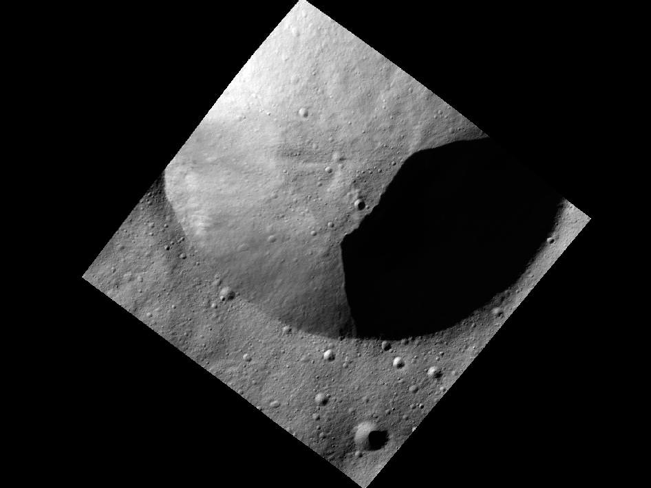
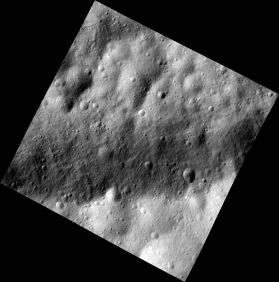
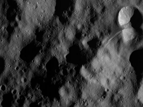
Crater in Shadow on Vesta. This new image from Dawn in its low altitude mapping orbit on Dec. 13 shows part of the rim of a fresh crater on Vesta located in an area known as the Heavily Cratered Terrain in the northern hemisphere at around 17 degrees latitude and 77 degrees longitude. It was obtained at an altitude of 119 miles (191 km) and covers an area 11 mi x 11 mi (18 km x 18 km). Credit: NASA/JPL-Caltech/UCLA/MPS/DLR/IDA

[/caption]

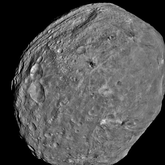
NASA’s Dawn spacecraft has swooped down to the closest orbit above the monster asteroid Vesta that the craft’s cameras and spectrometers will ever glimpse and the probe has begun transmitting these highest resolution pictures to anxiously waiting scientists back on Earth.

Dawn arrived at its Low Altitude Mapping Orbit, known as LAMO, on Dec. 12, 2011 and will continue circling scarcely 130 miles (210 kilometers) above Vesta for at least the next 10 weeks. Each orbit takes about 4.3 hours.

NASA has now released the first batch of crisp new close-ups images taken by the Framing Camera on Dec. 13 showing the stippled and lumpy surface in an exquisitely fine detail never seen before.

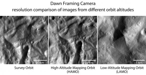
The photo montage below shows side by side views of the same portion of the Vestan surface at ever increasing resolution and clarity from ever lower altitudes.

Closer and Closer to the Vesta Surface
NASA’s Dawn spacecraft has spiraled closer and closer to the surface of the giant asteroid Vesta since arriving in mid-2011. The two images on the left represent an identical area, first observed during Dawn's survey orbit (far left image). The picture in the center is from Dawn's high-altitude mapping orbit (HAMO) from an altitude of about 430 miles (700 km) with about 230 feet (70 meters-per-pixel) resolution. The image at right was obtained on Dec. 13 from the low altitude mapping orbit (LAMO) at an altitude of 124 miles (199 km) above the surface and has a resolution of 75 feet (23 m) per pixel. It shows small impact craters or slumping at the steep-flanked mountain in the image center that can be identified in the two images to the left. Credit: NASA/JPL-Caltech/UCLA/MPS/DLR/IDA

The high resolution image gallery reveals fine scale highlights such as multitudes of small craters, grooves and lineaments, landslides and slumping, ejecta from past colossal impacts, and small outcrops of bright and dark materials.

The science team, led by Principal Investigator Prof Chris Russell of UCLA, believes that Vesta is actually more like a planet than an asteroid based on the data obtained thus far.

Vesta is the smallest terrestrial planet in our Solar System”, Russell told Universe Today. “We do not have a good analog to Vesta anywhere else in the Solar System.”

The primary science objectives at the LAMO orbit are to measure the elemental abundances on the surface of Vesta with the US built gamma ray and neutron detector (GRaND) and to probe the interior structure of the asteroid by measuring the gravity field.

Vesta is a proto-planet formed just a few million years after the birth of the solar system whose evolution into a larger planet was stopped cold by the massive gravitational influence of the planet Jupiter.

Scientists are plowing through thousands of images and millions of spectral measurements to glean clues about the origin and evolution of the solar system that have been preserved on the hitherto unexplored world.

Buried Craters on Vesta
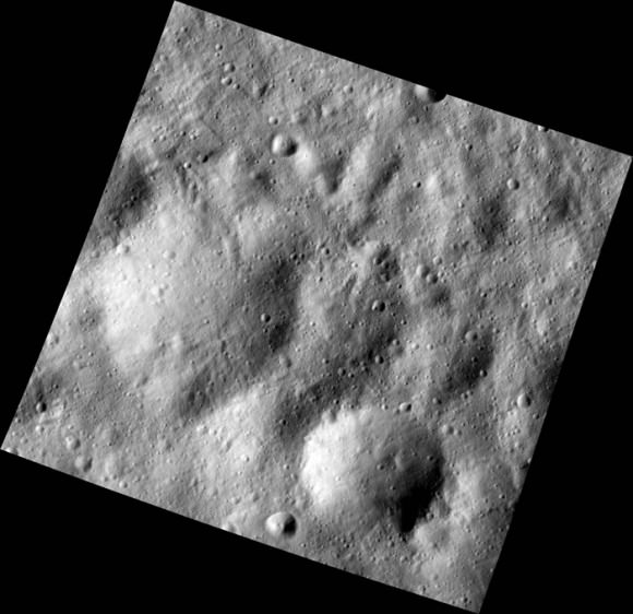
This Dec. 13 image from Dawn spacecraft in its low altitude mapping orbit shows many buried craters located within the equatorial trough region of Vesta. This area bears traces of the material thrown out by the impact that created the Rheasilvia basin in the asteroid’s south polar region. Lineated features are visible in a variety of shapes and sizes from an altitude of 117 miles (189 km) over an area of 11 mi x 11 mi (18 km x 18 km). Credit: NASA/JPL-Caltech/UCLA/MPS/DLR/IDA

“Vesta is a transitional body between a small asteroid and a planet and is unique in many ways,” says mission scientist Vishnu Reddy of the Max Planck Institute for Solar System Research in Katlenburg-Lindau, Germany. “Vesta is unlike any other asteroid we have visited so far.”

After completing the LAMO measurements, Dawn will again spiral back to a higher altitude for further data gathering especially at the unseen North Pole which is in darkness now.

Dawn will continue orbiting Vesta until July 2012 when it will fire up its ion propulsion system and depart for Ceres, the largest body in the main Asteroid belt between Mars and Jupiter.

“What can be more exciting than to explore an alien world that until recently was virtually unknown!” Dr. Marc Rayman told Universe Today. Rayman is Dawn’s Chief Engineer from NASA’s Jet Propulsion Lab (JPL) in Pasadena, Calif.

Equatorial Trough in Dark and Bright on Vesta
This image was one of the first obtained by Dawn in its low altitude mapping orbit and shows a part of one of the long troughs at the equator of Vesta. Credit: NASA/ JPL-Caltech/ UCLA/ MPS/ DLR/ IDA

“Dawn continues to gather gamma ray spectra and neutron spectra,” Rayman reports. “The bonus imaging at LAMO is yielding pictures more than three times better than those acquired in the high altitude mapping orbit (HAMO). Every week at this low altitude, Dawn will use its ion propulsion system to fine tune its orbit. The first of these weekly orbit adjustments was performed on December 17.”

The framing cameras eere built by the Max Planck Institute for Solar System Research in Germany.

A treasure trove of spectacular Vesta close-ups are streaming at this moment to the home planet and we’ll have many more goodies to show.

Read continuing features about Dawn by Ken Kremer starting here:
Holiday Greetings from an Alien Snowman on Vesta
Dawn swoops to lowest orbit around Vesta – Unveiling Spectacular Alien World
Rainbow of Colors Reveal Asteroid Vesta as More Like a Planet
Vrooming over Vivid Vestan Vistas in Vibrant 3 D – Video
NASA Planetary Science Trio Honored as ‘Best of What’s New’ in 2011- Curiosity/Dawn/MESSENGER
Dawn Discovers 2nd Giant South Pole Impact Basin at Strikingly Dichotomous Vesta
Amazing New View of the Mt. Everest of Vesta
Dramatic 3 D Imagery Showcases Vesta’s Pockmarked, Mountainous and Groovy Terrain

Curiosity Starts First Science on Mars Sojurn – How Lethal is Space Radiation to Life’s Survival

NASA's Mars Science Laboratory Curiosity rover will investigate Mars' past or present ability to sustain microbial life. Curiosity is cruising to Mars and has already investigating the lethality of the space radiation environment to humans. Credit: NASA/JPL-Caltech

[/caption]

Barely two weeks into the 8 month journey to the Red Planet, NASA’s Curiosity Mars Science Lab (MSL) rover was commanded to already begin collecting the first science of the mission by measuring the ever present radiation environment in space.

Engineers powered up the MSL Radiation Assessment Detector (RAD) that monitors high-energy atomic and subatomic particles from the sun, distant supernovas and other sources.

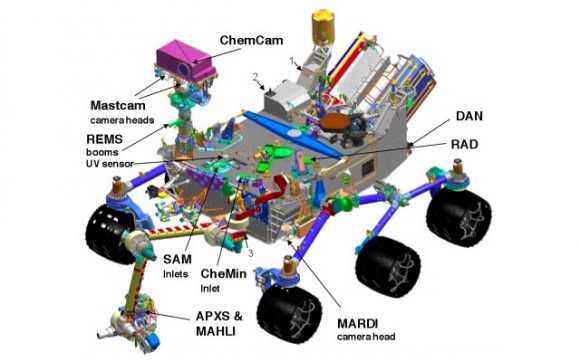
RAD is the only one of the car-sized Curiosity’s 10 science instrument that will operate both in space as well as on the Martian surface. It will provide key data that will enable a realistic assessment of the levels of lethal radiation that would confront any potential life forms on Mars as well as Astronauts voyaging between our solar systems planets.

“RAD is the first instrument on Curiosity to be turned on. It will operate throughout the long journey to Mars,” said Don Hassler, RAD’s principal investigator from the Southwest Research Institute in Boulder, Colo.

These initial radiation measurements are focused on illuminating possible health effects facing future human crews residing inside spaceships.


Video Caption: The Radiation Assessment Detector is the first instrument on Curiosity to begin science operations. It was powered up and began collecting data on Dec. 6, 2011. Credit: NASA

“We want to characterize the radiation environment inside the spacecraft because it’s different from the radiation environment measured in interplanetary space,” says Hassler.

RAD is located on the rover which is currently encapsulated within the protective aeroshell. Therefore the instrument is positioned inside the spacecraft, simulating what it would be like for an astronaut with some shielding from the external radiation, measuring energetic particles.

“The radiation hitting the spacecraft is modified by the spacecraft, it gets changed and produces secondary particles. Sometimes those secondary particles can be more damaging than the primary radiation itself.”

“What’s new is that RAD will measure the radiation inside the spacecraft, which will be very similar to the environment that a future astronaut might see on a future mission to Mars.”

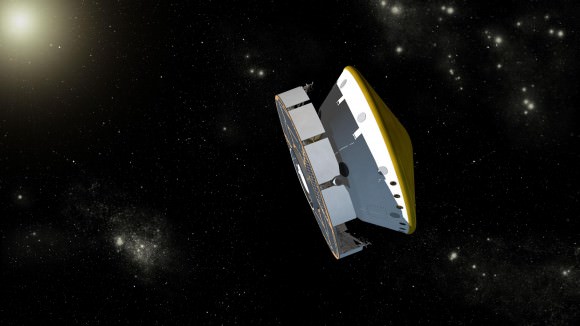
Curiosity Mars Science Laboratory (MSL) Spacecraft During Cruise with Navigation Stars. Artist's concept of Curiosity during its cruise phase between launch on Nov. 26, 2011 and final approach to Mars in August 2012. Credit: NASA/JPL-Caltech

Curiosity’s purpose is to search for the ingredients of life and assess whether the rovers landing site at Gale Crater could be or has been favorable for microbial life.

The Martian surface is constantly bombarded by deadly radiation from space. Radiation can destroy the very organic molecules which Curiosity seeks.

“After Curiosity lands, we’ll be taking radiation measurements on the surface of another planet for the first time,” notes Hassler.

RAD was built by a collaboration of the Southwest Research Institute, together with Christian Albrechts University in Kiel, Germany with funding from NASA’s Human Exploration Directorate and Germany’s national aerospace research center, Deutsches Zentrum für Luft- und Raumfahrt.

“What Curiosity might find could be a game-changer about the origin and evolution of life on Earth and elsewhere in the universe,” said Doug McCuistion, director of the Mars Exploration Program at NASA Headquarters in Washington. “One thing is certain: The rover’s discoveries will provide critical data that will impact human and robotic planning and research for decades.”

Curiosity was launched from Florida on Nov. 26. After sailing on a 254 day and 352-million-mile (567-million-kilometer) interplanetary flight from the Earth to Mars, Curiosity will smash into the atmosphere at 13,000 MPH on August 6, 2012 and pioneer a nail biting and first-of-its-kind precision rocket powered descent system to touchdown inside layered terrain at Gale Crater astride a 3 mile (5 km) high mountain that may have preserved evidence of ancient or extant Martian life.

Miraculously, NASA’s Opportunity Mars rover and onboard instruments and cameras have managed to survive nearly 8 years of brutally harsh Martian radiation and arctic winters.

Curiosity MSL science instruments are state-of-the-art tools for acquiring information about the geology, atmosphere, environmental conditions, and potential biosignatures on Mars. Credit: NASA

Complete Coverage of Curiosity – NASA’s Next Mars Rover launched 26 Nov. 2011
Read continuing features about Curiosity by Ken Kremer starting here:
Flawlessly On Course Curiosity Cruising to Mars – No Burn Needed Now
NASA Planetary Science Trio Honored as ‘Best of What’s New’ in 2011- Curiosity/Dawn/MESSENGER
Curiosity Mars Rover Launch Gallery – Photos and Videos
Curiosity Majestically Blasts off on ‘Mars Trek’ to ascertain ‘Are We Alone?
Mars Trek – Curiosity Poised to Search for Signs of Life
Curiosity Rover ‘Locked and Loaded’ for Quantum Leap in Pursuit of Martian Microbial Life
Science Rich Gale Crater and NASA’s Curiosity Mars Rover in Glorious 3-D – Touchdown in a Habitable Zone
Curiosity Powered Up for Martian Voyage on Nov. 26 – Exclusive Message from Chief Engineer Rob Manning
NASA’s Curiosity Set to Search for Signs of Martian Life
Curiosity Rover Bolted to Atlas Rocket – In Search of Martian Microbial Habitats
Closing the Clamshell on a Martian Curiosity
Curiosity Buttoned Up for Martian Voyage in Search of Life’s Ingredients
Assembling Curiosity’s Rocket to Mars
Encapsulating Curiosity for Martian Flight Test
Dramatic New NASA Animation Depicts Next Mars Rover in Action

New Study Says Large Regions of Mars Could Sustain Life

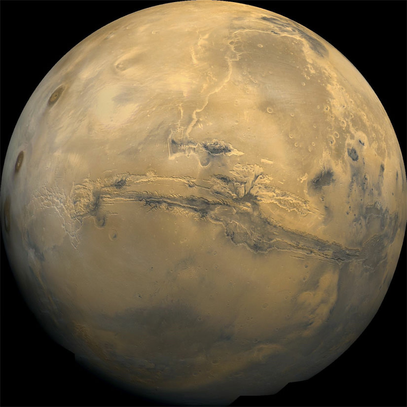
The Planet Mars. Image credit: NASA

[/caption]

The question of whether present-day Mars could be habitable, and to what extent, has been the focus of long-running and intense debates. The surface, comparable to the dry valleys of Antarctica and the Atacama desert on Earth, is harsh, with well-below freezing temperatures most of the time (at an average of minus 63 degrees Celsius or minus 81 Fahrenheit), extreme dryness and a very thin atmosphere offering little protection from the Sun’s ultraviolet radiation. Most scientists would agree that the best place that any organisms could hope to survive and flourish would be underground. Now, a new study says that scenario is not only correct, but that large regions of Mars’ subsurface could be even more sustainable for life than previously thought.

Scientists from the Australian National University modeled conditions on Mars on a global scale and found that large regions could be capable of sustaining life – three percent of the planet actually, albeit mostly underground. By comparison, just one percent of Earth’s volume, from the central core to the upper atmosphere, is inhabited by some kind of life. They compared pressure and temperature conditions on Earth to those of Mars to come up with the surprising results.

According to Charley Lineweaver of ANU, “What we tried to do, simply, was take almost all of the information we could and put it together and say ‘is the big picture consistent with there being life on Mars?’ And the simple answer is yes… There are large regions of Mars that are compatible with terrestrial life.”

So it seems that while, as we know, the surface of Mars is quite inhospitable to most forms of life (that we know of) except perhaps for some extremophiles, conditions underground are a different matter. It is already known that there are vast deposits of ice below the surface even near the equator (as well as the polar ice caps of course), so there could be liquid water a bit deeper where it is warmer. Those conditions would be ideal for bacteria or other simple organisms. While that idea has been proposed and discussed before, Lineweaver’s findings support it on a planet-wide basis – previous studies tended to focus on specific locations in a “piecemeal” approach, but these new ones take the entire planet into consideration.

The paper is currently available for free here. Abstract:

We present a comprehensive model of martian pressure-temperature (P-T) phase space and compare it with that of Earth. Martian P-T conditions compatible with liquid water extend to a depth of *310 km. We use our phase space model of Mars and of terrestrial life to estimate the depths and extent of the water on Mars that is habitable for terrestrial life. We find an extensive overlap between inhabited terrestrial phase space and martian phase space. The lower martian surface temperatures and shallower martian geotherm suggest that, if there is a hot deep biosphere on Mars, it could extend 7 times deeper than the *5km depth of the hot deep terrestrial biosphere in the crust inhabited by hyperthermophilic chemolithotrophs. This corresponds to *3.2% of the volume of present-day Mars being potentially habitable for terrestrial-like life. Key Words: Biosphere—Mars— Limits of life—Extremophiles—Water. Astrobiology 11, xxx–xxx.

Dawn swoops to lowest orbit around Vesta – Unveiling Spectacular Alien World

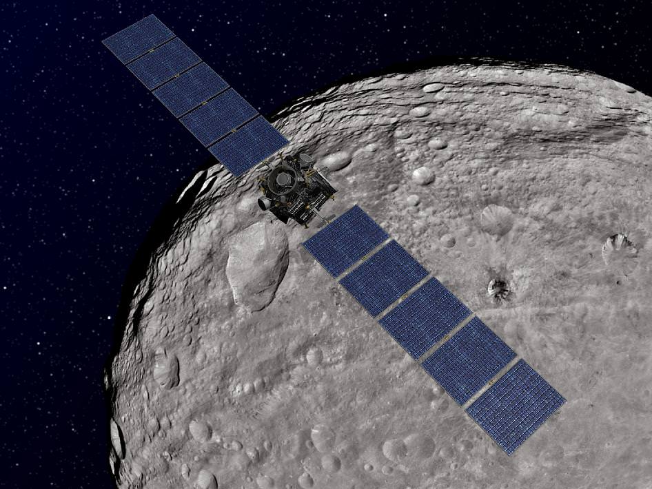
Dawn Orbiting Vesta. This artist's concept shows NASA's Dawn spacecraft orbiting the giant asteroid Vesta. The depiction of Vesta is based on images obtained by Dawn's framing cameras. Dawn is an international collaboration of the US, Germany and Italy. Credit: NASA/JPL-Caltech

[/caption]

NASA’s Dawn Asteroid Orbiter successfully spiraled down today to the closest orbit the probe will ever achieve around the giant asteroid Vesta, and has now begun critical science observations that will ultimately yield the mission’s highest resolution measurements of this spectacular body.

“What can be more exciting than to explore an alien world that until recently was virtually unknown!” Dr. Marc Rayman gushed in an exclusive interview with Universe Today. Rayman is Dawn’s Chief Engineer from NASA’s Jet Propulsion Lab (JPL) in Pasadena, Calif., and a protégé of Star Trek’s Mr. Scott.

Before Dawn, Vesta was little more than a fuzzy blob in the world’s most powerful telescopes. Vesta is the second most massive object in the main Asteroid Belt between Mars and Jupiter.

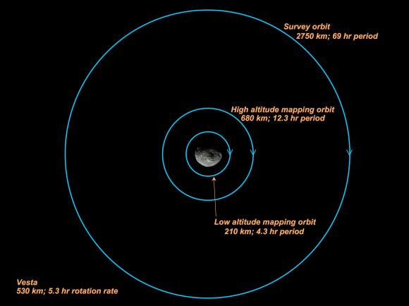
Dawn is now circling about Vesta at the lowest planned mapping orbit, dubbed LAMO for Low Altitude Mapping Orbit. The spacecraft is orbiting at an average altitude of barely 130 miles (210 kilometers) above the heavily bombarded and mysterious world that stems from the earliest eons of our solar system some 4.5 Billion years ago. Each orbit takes about 4.3 hours.

“It is both gratifying and exciting that Dawn has been performing so well,” Rayman told me.

Dawn Orbiting Over Vesta - A Hi Res Taste of What's Ahead!
This image of the giant asteroid Vesta was obtained by Dawn in the evening Nov. 27 PST (early morning Nov. 28, UTC), as it was spiraling down from its high altitude mapping orbit to low altitude mapping orbit. Low altitude mapping orbit is the closest orbit Dawn will be making, at an average of 130 miles (210 kilometers) above the giant asteroid's surface. The framing camera obtained this image of an area in the northern mid-latitudes of Vesta from an altitude of about 140 miles (230 kilometers). Credit: NASA/JPL-Caltech/UCLA/MPS/DLR/IDA

Dawn arrived in orbit at Vesta in July 2011 after a nearly 4 year interplanetary cruise since blasting off atop a Delta II rocket from Cape Canaveral, Florida in September 2007. The probe then spent the first few weeks at an initial science survey altitude of about 1,700 miles (2,700 kilometers).

Gradually the spaceship spiraled down closer to Vesta using her ion propulsion thrusters.

See Vesta science orbit diagram, below, provided courtesy of Dr. Marc Rayman.

Along the way, the international science and engineering team commanded Dawn to make an intermediate stop this past Fall 2011 at the High Altitude Mapping orbit altitude (420 miles, or 680 kilometers).

“It is so cool now to have reached this low orbit [LAMO]. We already have a spectacular collection of images and other fascinating data on Vesta, and now we are going to gain even more,” Rayman told me.

“We have a great deal of work ahead to acquire our planned data here, and I’m looking forward to every bit!

Dawn will spend a minimum of 10 weeks acquiring data at the LAMO mapping orbit using all three onboard science instruments, provided by the US, Germany and Italy.

While the framing cameras (FC) from Germany and the Visible and Infrared Mapping spectrometer (VIR) from Italy will continue to gather mountains of data at their best resolution yet, the primary science focus of the LAMO orbit will be to collect data from the gamma ray and neutron detector (GRaND) and the gravity experiment.

GRaND will measure the elemental abundances on the surface of Vesta by studying the energy and neutron by-products that emanate from it as a result of the continuous bombardment of cosmic rays. The best data are obtained at the lowest altitude.

Dawn spacecraft - Science orbits at Vesta
Credit: NASA/JPL-Caltech/Marc Rayman

By examining all the data in context, scientists hope to obtain a better understanding of the formation and evolution of the early solar system.

Vesta is a proto-planet, largely unchanged since its formation, and whose evolution into a larger planet was stopped cold by the massive gravitational influence of the planet Jupiter.

Dawn’s visit to Vesta has been eye-opening so far, showing us troughs and peaks that telescopes only hinted at,” said Christopher Russell, Dawn’s principal investigator, based at UCLA. “It whets the appetite for a day when human explorers can see the wonders of asteroids for themselves.”

After investigating Vesta for about a year, the engineers will ignite Dawn’s ion propulsion thrusters and blast away to Ceres, the largest asteroid which may harbor water ice and is another potential outpost for extraterrestrial life

Dawn will be the first spaceship to orbit two worlds and is also the first mission to study the asteroid belt in detail.

Asteroid Vesta from Dawn - Exquisite Clarity from a formerly Fuzzy Blob
NASA's Dawn spacecraft obtained this image of the giant asteroid Vesta with its framing camera on July 24, 2011. It was taken from a distance of about 3,200 miles (5,200 kilometers). Before Dawn, Vesta was just a fuzzy blob in the most powerful telescopes. Dawn entered orbit around Vesta on July 15, and will spend a year orbiting the body before firing up the ion propulsion system to break orbit and speed to Ceres, the largest Asteroid. Credit: NASA/JPL-Caltech/UCLA/MPS/DLR/IDA
South Polar Region of Vesta - Enhanced View
An ancient cosmic collision blasted away much of the south pole of Vesta, leaving behind an enoumous mountain about 3 times the height of Mt. Everest. NASA's Dawn spacecraft obtained this image centered on the south pole of Vesta with its framing camera on July 18, 2011 as it passed the terminator. The image has been enhanced to bring out more surface details. It was taken from a distance of about 6,500 miles (10,500 kilometers) away from the protoplanet Vesta. The smallest detail visible is about 1.2 miles (2.0 km). Credit: NASA/JPL-Caltech/UCLA/MPS/DLR/IDA. Enhanced and annotated by Ken Kremer

Read continuing features about Dawn by Ken Kremer starting here:

Rainbow of Colors Reveal Asteroid Vesta as More Like a Planet
Vrooming over Vivid Vestan Vistas in Vibrant 3 D – Video
NASA Planetary Science Trio Honored as ‘Best of What’s New’ in 2011- Curiosity/Dawn/MESSENGER
Dawn Discovers Surprise 2nd Giant South Pole Impact Basin at Strikingly Dichotomous Vesta
Amazing New View of the Mt. Everest of Vesta
Dramatic 3 D Imagery Showcases Vesta’s Pockmarked, Mountainous and Groovy Terrain
Rheasilvia – Super Mysterious South Pole Basin at Vesta
Space Spectacular — Rotation Movies of Vesta
3 D Alien Snowman Graces Vesta
NASA Unveils Thrilling First Full Frame Images of Vesta from Dawn
Dawn Spirals Down Closer to Vesta’s South Pole Impact Basin

Opportunity Discovers Most Powerful Evidence Yet for Martian Liquid Water

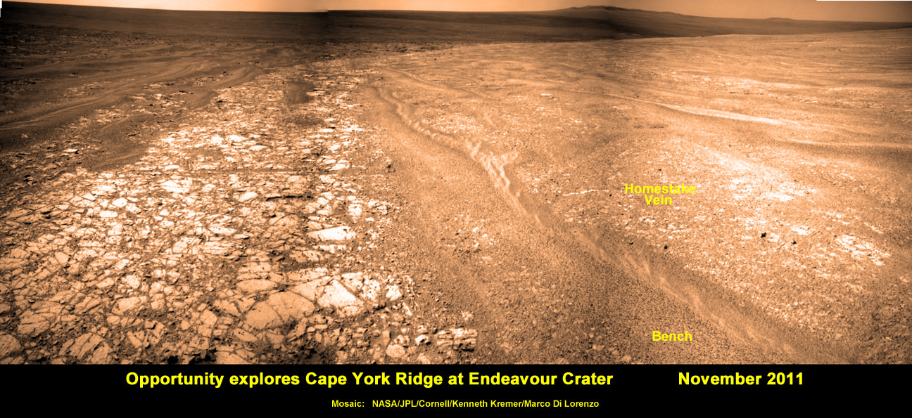
Opportunity discovers Water related mineral vein at Endeavour Crater - November 2011. Opportunity rover discovered Gypsum at the Homestake mineral vein, while exploring around the base of Cape York ridge at the rim of Endeavour Crater. The vein is composed of calcium sulfate and indicates the ancient flow of liquid water at this spot on Mars. Opportunity drove North (ahead) from here in search of a sunny winter haven. Credit: NASA/JPL/Cornell/Kenneth Kremer/Marco Di Lorenzo

[/caption]

NASA’s long lived Opportunity rover has discovered the most scientifically compelling evidence yet for the flow of liquid water on ancient Mars. The startling revelation comes in the form of a bright vein of the mineral gypsum located at the foothills of an enormous crater named Endeavour, where the intrepid robot is currently traversing. See our mosaic above, illustrating the exact spot.

Update: ‘Homestake’ Opportunity Mosaic above has just been published on Astronomy Picture of the Day (APOD) – 12 Dec 2011 (by Ken Kremer and Marco Di Lorenzo)

Researchers trumpeted the significant water finding this week (Dec. 7) at the annual winter meeting of the American Geophysical Union (AGU) in San Francisco.

“This gypsum vein is the single most powerful piece of evidence for liquid water at Mars that has been discovered by the Opportunity rover,” announced Steve Squyres of Cornell University, Ithaca, N.Y., Principal Investigator for Opportunity, at an AGU press conference.

The light-toned vein is apparently composed of the mineral gypsum and was deposited as a result of precipitation from percolating pools of liquid water which flowed on the surface and subsurface of ancient Mars, billions of years ago. Liquid water is an essential prerequisite for life as we know it.

“This tells a slam-dunk story that water flowed through underground fractures in the rock,” said Squyres. “This stuff is a fairly pure chemical deposit that formed in place right where we see it. That can’t be said for other gypsum seen on Mars or for other water-related minerals Opportunity has found. It’s not uncommon on Earth, but on Mars, it’s the kind of thing that makes geologists jump out of their chairs.”

'Homestake' Vein in Color and Close-up
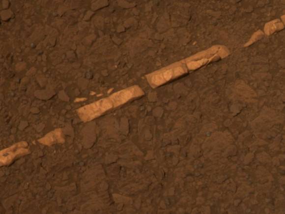
This color view of a mineral vein called "Homestake" was taken by the panoramic camera (Pancam) on NASA's Mars Exploration Rover Opportunity. The vein is about the width of a thumb and about 18 inches (45 centimeters) long. Opportunity examined it in November 2011 and found it to be rich in calcium and sulfur, possibly the calcium-sulfate mineral gypsum.

The light-toned vein is informally named “Homestake”, and was examined up close by Opportunity’s cameras and science instruments for several weeks this past month in November 2011, as the rover was driving northwards along the western edge of a ridge dubbed ‘Cape York’ – which is a low lying segment of the eroded rim of Endeavour Crater.

Veins are a geologic indication of the past flow of liquid water

Opportunity just arrived at the rim of the 14 mile (22 kilometere) wide Endeavour Crater in mid-August 2011 following an epic three year trek across treacherous dune fields from her prior investigative target at the ½ mile wide Victoria Crater.

“It’s like a whole new mission since we arrived at Cape York,” said Squyres.

‘Homestake’ is a very bright linear feature.

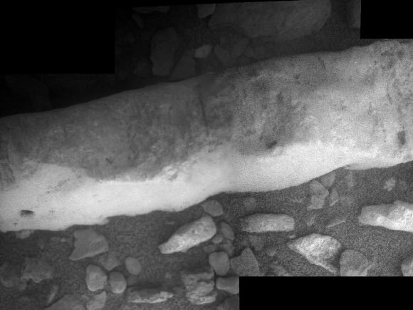
“The ‘Homestake’ vein is about 1 centimeter wide and 40 to 50 centimeters long,” Squyres elaborated. “It’s about the width of a human thumb.”

Opportunity's Approach to 'Homestake'
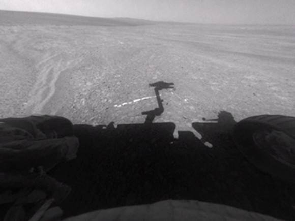
This view from the front hazard-avoidance camera on NASA's Mars Exploration Rover Opportunity shows the rover's arm's shadow falling near a bright mineral vein informally named Homestake. The vein is about the width of a thumb and about 18 inches (45 centimeters) long. Opportunity examined it in November 2011 and found it to be rich in calcium and sulfur, possibly the calcium-sulfate mineral gypsum. Opportunity took this image on Sol 2763 on Mars (Nov. 7, 2011). Credit: NASA/JPL-Caltech

Homestake protrudes slightly above the surrounding ground and bedrock and appears to be part of a system of mineral veins running inside an apron (or Bench) that in turn encircles the entire ridge dubbed Cape York.

In another first, no other veins like these have been seen by Opportunity throughout her entire 20 miles (33 kilometers) and nearly eight year long Martian journey across the cratered, pockmarked plains of Meridiani Planum, said Squyres.

The veins have also not been seen in the higher ground around the rim at Endeavour crater.

“We want to understand why these veins are in the apron but not out on the plains,” said the mission’s deputy principal investigator, Ray Arvidson, of Washington University in St. Louis. “The answer may be that rising groundwater coming from the ancient crust moved through material adjacent to Cape York and deposited gypsum, because this material would be relatively insoluble compared with either magnesium or iron sulfates.”

Opportunity was tasked to engage her Microscopic Imager and Alpha Particle X-ray Spectrometer (APXS) mounted on the terminus of the rover’s arm as well as multiple filters of the mast mounted Panoramic Camera to examine ‘Homestake’.

“The APXS spectrometer shows ’Homestake’ is chock full of Calcium and Sulfur,” Squyres gushed.

Microscopic Close-up View of 'Homestake' Vein
This close-up view of a mineral vein called Homestake comes from the microscopic imager on Opportunity. The vein is about the width of a thumb and about 18 inches (45 centimeters) long. Opportunity examined it in November 2011 and found it to be rich in calcium and sulfur, possibly the calcium-sulfate mineral gypsum. Homestake is near the edge of the "Cape York" segment of the western rim of Endeavour Crater. This view blends three exposures taken by the microscopic imager during the 2,765th and 2,766th Martian days, or sols, of Opportunity's career on Mars (Nov. 3 and 4, 2011). Credit: NASA/JPL-Caltech/Cornell/USGS

The measurements of composition with the APXS show that the ratio points to it being relatively pure calcium sulfate, Squyres explained. “One type of calcium sulfate is gypsum.”

Calcium sulfate can have varying amounts of water bound into the minerals crystal structure.

The rover science team believes that this form of gypsum discovered by Opportunity is the dihydrate; CaSO4•2H2O. On Earth, gypsum is used for making drywall and plaster of Paris.

The gypsum was formed in the exact spot where Opportunity found it – unlike the sulfate minerals previously discovered which were moved around by the wind and other environmental and geologic forces.

“There was a fracture in the rock, water flowed through it, gypsum was precipitated from the water. End of story,” Squyres noted. “There’s no ambiguity about this, and this is what makes it so cool.”

At Homestake we are seeing the evidence of the ground waters that flowed through the ancient Noachian rocks and the precipitation of the gypsum, which is the least soluble of the sulfates, and the other magnesium and iron sulfates which Opportunity has been driving on for the last 8 years.

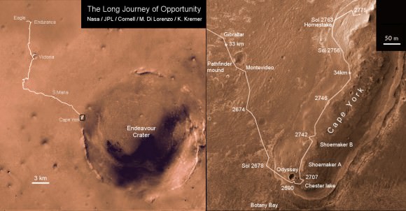
Opportunity Traverse Map 2004 to 2011
Traverse map showing the 8 Year Journey of Opportunity from Eagle Crater landing site Sol 1 (Jan. 24, 2004) to Sol 2775 (November 2011). Map shows rover location around Homestake water related mineral on Sol 2763 (November 2011) at Cape York ridge at Endeavour Crater rim. Endeavour Crater is 14 miles or 22 kilometers in diameter. Opportunity has driven more than 21 miles (34 km).
Credit: NASA/JPL/Cornell/Marco Di Lorenzo/Kenneth Kremer

“Here, both the chemistry, mineralogy, and the morphology just scream water,” Squyres exclaimed. “This is more solid than anything else that we’ve seen in the whole mission.”

It’s inconceivable that the vein is something else beside gypsum, said Squyres.

As Opportunity drove from the plains of Meridiani onto the rim of Endeavour Crater and Cape York, it crossed a geologic boundary and arrived at a much different and older region of ancient Mars.

The evidence for flowing liquid water at Endeavour crater is even more powerful than the silica deposits found by Spirit around the Home Plate volcanic feature at Gusev Crater a few years ago.

“We will look for more of these veins in the [Martian] springtime,” said Squyres.

If a bigger, fatter vein can be found, then Opportunity will be directed to grind into it with her still well functioning Rock Abrasion Tool, or RAT.

Homestake was crunched with the wheels – driving back and forth over the vein – to break it up and expose the interior. Opportunity did a triple crunch over Homestake, said Arvidson.

Homestake was found near the northern tip of Cape York, while Opportunity was scouting out a “Winter Haven” location to spend the approaching Martian winter.

Arvidson emphasized that the team wants Opportunity to be positioned on a northerly tilted slope to catch the maximum amount of the sun’s rays to keep the rover powered up for continuing science activities throughout the fast approaching Martian winter.

“Martian winter in the southern hemisphere starts on March 29, 2012. But, Solar power levels already begin dropping dramatically months before Martian winter starts,” said Alfonso Herrera to Universe Today, Herrera is a Mars rover mission manager at NASA’s Jet Propulsion Laboratory in Pasadena, Calif.

“Opportunity is in excellent health,” said Bruce Banerdt, the Project Scientist for the Mars rover mission at JPL.

“This has been a very exciting time. We’ll head back south in the springtime and have a whole bunch of things to do with a very capable robot,” Squyres concluded.

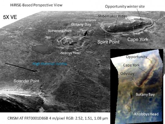
'Botany Bay' and 'Cape York' with Vertical Exaggeration
This graphic combines a perspective view of the "Botany Bay" and "Cape York" areas of the rim of Endeavour Crater on Mars, and an inset with mapping-spectrometer data. Major features are labeled. In the perspective view, the landscape's vertical dimension is exaggerated five-fold compared with horizontal dimensions. NASA's Mars Exploration Rover Opportunity examined targets in the Cape York area during the second half of 2011. The perspective view was generated by producing an elevation map from a stereo pair of images from the High Resolution Imaging Science Experiment (HiRISE) camera on NASA's Mars Reconnaissance Orbiter, then draping one of the HiRISE images over the elevation model. The inset presents data from the Compact Reconnaissance Imaging Spectrometer for Mars (CRISM) instrument on the Mars Reconnaissance Orbiter. In this CRISM observation, taken on March 29, 2011 Thermal inertia estimates from observations by the Thermal Emission Imaging System on NASA's Mars Odyssey orbiter indicate that Botany Bay is a region with extensive outcrop exposures. Credit: NASA/JPL-Caltech/UA/JHUAPL

Meanwhile, NASA’s next leap in exploring potential Martian habitats for life – the car sized Curiosity Mars Science Lab rover – is speeding towards the Red Planet.

Read Ken’s continuing features about Opportunity starting here:

NASA Robot seeks Goldmine of Science and Sun at Martian Hill along vast Crater
Opportunity spotted Exploring vast Endeavour Crater from Mars Orbit
Twin Towers 9/11 Tribute by Opportunity Mars Rover
NASA Robot arrives at ‘New’ Landing Site holding Clues to Ancient Water Flow on Mars
Opportunity Arrives at Huge Martian Crater with Superb Science and Scenic Outlook
Opportunity Snaps Gorgeous Vistas nearing the Foothills of Giant Endeavour Crater