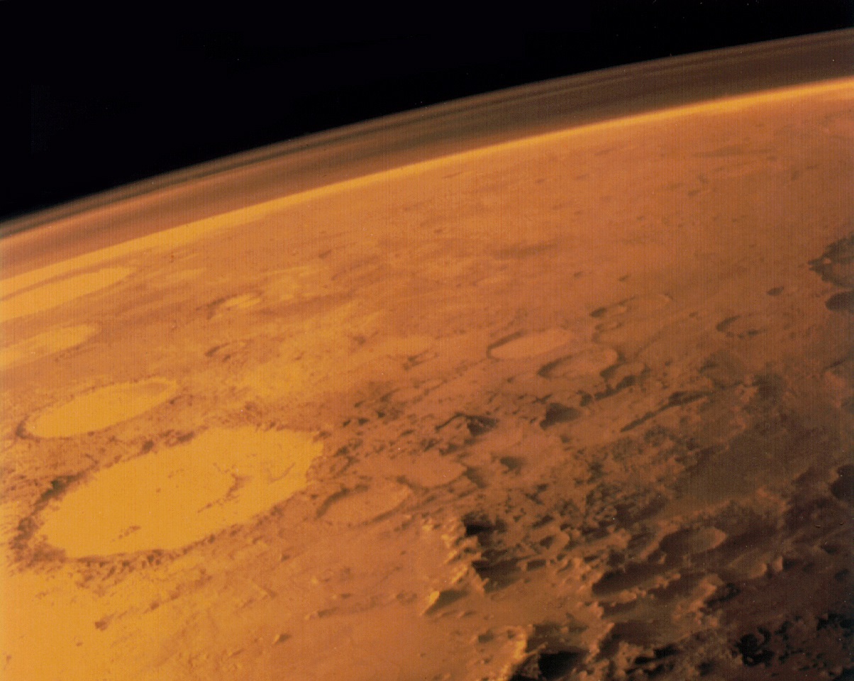
Image taken by the Viking 1 orbiter in June 1976, showing Mars thin atmosphere and dusty, red surface. Credits: NASA/Viking 1
One of the most significant finds to come from our ongoing exploration and research efforts of Mars is the fact that the planet once had a warmer, wetter environment. Between 4.2 and 3.7 billion years ago, the planet had a thicker atmosphere and was able to maintain liquid water on its surface. As such, it has been ventured that life could have once existed there, and might still exist there in some form.
However, according to some recent lab tests by a pair of researchers from the UK Center for Astrobiology at the University of Edinburgh, Mars may be more hostile to life than previously thought. Not only does this not bode well for those currently engaged in the hunt for life on Mars (sorry Curiosity!), it could also be bad news for anyone hoping to one day grow things on the surface (sorry Mark Watney!).
Their study, titled “Perchlorates on Mars Enhance the Bacteriocidal Effects of UV Light“, was recently published in the journal Science Reports. Performed by Jennifer Wadsworth and Charles Cockell – a postgraduate student and a professor of astrobiology at the UK Center for Astrobiology, respectively – the purpose of this study was to see how perchlorates (a chemical compound that is common to Mars) behaved under Mars-like conditions.
An artist’s impression of what Mars might have looked like with water, when any potential Martian microbes would have evolved. Credit: ESO/M. Kornmesser
Basically, perchlorates are a negative ion of chlorine and oxygen that are found on Earth. When the Pheonix lander touched down on Mars in 2008, it found that this chemical was also found on the Red Planet. While stable at room temperature, perchlorates become active when exposed to high levels of heat energy. And under the kinds of conditions associated with Mars, they become rather toxic.
Interestingly enough, the presence of perchlorates on the surface of Mars was presented in 2015 as evidence of there being liquid water there in the past. This was due to the fact that these compounds were found both in-situ and as part of what are known as “brine sweeps”. In other words, some of the discovered perchlorates took the form of streaky lines that were thought to have been the result of water evaporating.
Water, as we all know, is also an essential ingredient to life as we know it, and it’s discovery of Mars was seen as evidence that life could have once existed there. Hence, as Jennifer Wadsworth (the study’s lead author) told Universe Today via email, she and Dr. Cockell were interested to see how such compounds would behave under conditions that are particular to Mars:
“There is a relatively large amount of perchlorate on Mars (0.6 weight percent) and it was confirmed to be a component of a Martian brine by NASA in 2015. It has been speculated that these brines may be habitable. There has been previous work done showing that perchlorates can be ‘activated’ by ionizing radiation which leads them to chlorinate amino acids and degrade organics. We wanted to test whether perchlorate could be activated by UV under Martian environmental conditions to directly kill bacteria. We thought it would be interesting to investigate in light of the discussions of brine habitability.”
Scientists were able to gauge the rate of water loss on Mars by measuring the ratio of water
After recreating the temperature conditions that are common to the Martian surface, Wadsworth and Cockell began exposing the samples to ultra-violet light – which the surface of Mars gets plenty of exposure to. What they found was that under cold conditions, the samples became activated when exposed to UV radiation. And As Wadsworth explained, the results were less than encouraging:
“The main results were that perchlorate, that is usually only activated at high temperatures, can be activated by only using UV light. This is interesting because this compound is abundant on Mars (where it’s very cold), so we might have previously thought it wouldn’t be possible to activate it under Martian conditions. We also found the bactericidal effect increased when bacteria were irradiated with perchlorate and other Martian compounds (iron oxide and hydrogen peroxide). This is important because it is lethal to bacteria when activated. So, if we want to find life on Mars, we have to take this into consideration.”
Iron oxide – aka. rust – and hydrogen peroxide are two compounds that are also found in abundance on the surface of Mars. In fact, it is the prevalence of iron oxide in the soil that gives Mars its distinct, reddish appearance. When Wadsworth and Cockell added these compounds to the perchlorates, the result was nothing less than a 10.8-fold increase in the death of bacterial cells, when compared to perchlorates alone.
While the surface of Mars has long been suspected of having toxic effects, this study shows that it could actually be very hostile to living cells. Thanks to the toxic combination that is created when these three chemical compounds come together and are activated by UV light, the most basic of life forms may be unable to survive there. For those researchers attempting to determine if Mars could in fact be habitable, this is not good news!
Sorry, Mark Watney. Turns out, your potatoes are growing in dirt that is toxic to lifeforms. Credit: Twentieth Century Fox Film Corporation
It is also bad news as far as the existence of liquid water is concerned. While the presence of liquid water in Mars’ past was seen as compelling evidence for past habitability, this water would not have been particularly supportive for life as we know it. Not if these compounds were present in Mars’ surface water, which this study would seem to suggest. Luckily, this research does present a few silver linings.
On the one hand, the fact that perchlorates became hostile to B. subtilis in the presence of UV does not necessarily mean that the Martian surface is hostile to all life. Second, the presence of these bacteria-killing compounds means that contaminants left behind by robotic explorers are not likely to survive long. So the risk of contaminating Mars’ environment (always a going concern for any mission) is very low.
As Wadsworth explained, there are unanswered questions, and more research is necessary:
“We don’t know exactly how far reaching the effect of UV and perchlorate would penetrate the surface layers, as the precise mechanism isn’t understood. If it’s the case of altered forms of perchlorate (such as chlorite or hypochlorite) diffusing through the environment, that might extend the uninhabitable zone. If you’re looking for life you have to additionally keep the ionizing radiation in mind that can penetrate the top layers of soil, so I’d suggest digging at least a few meters into the ground to ensure the levels of radiation would be relatively low. At those depths, it’s possible Martian life may survive.”
As for all the potential Mark Watney’s out there (the protoganist from The Martian), there might be some good news as well. “Perchlorate can be dangerous to humans so we’d just have to make sure we keep it out of the austronauts’ living quarters,” said Wadsworth. “We could potentially use it in sterilization processes. I think the more immediate threat to Martian colonies would be the amount of radiation reaching the surface.”
So maybe we don’t need to cancel our tickets to Mars just yet! However, as the day draws nearer to where people like Elon Musk and Bas Lansdorp are able to make commercial trips to the Red Planet a reality, we will need to know precisely how terrestrial organisms will fare on the planet – and that includes us! And if the prospects don’t look good, we better make certain we have some decent counter-measures in place.
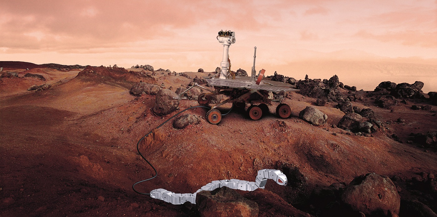
The picture shows an imaginary snake robot on Space Station – on the way to inspect anything for the astronaut. Credit: SINTEF
Human space exploration is going to kick into high gear in the coming decades. Within the inner Solar System alone, missions are being planned that will see robotic explorers and crews sent to Near Earth Objects (NEOs), back to the Moon, and even on to Mars. Beyond that, there are even plans to send robotic missions to Europa, Enceladus, Titan, and other “ocean worlds” to look for signs of life.
In all cases, questions natural arise as to what kinds of missions will be most suited to them. In the case of places like Titan (which have low gravity and dense atmospheres) aerial drones are considered the best bet. But when it comes to rocky place like asteroids, the Moon and Mars, the best candidate may be robot snakes, which could find their way through tight spaces and travel underground.
This concept was proposed three years ago by the Foundation for Scientific and Industrial Research (SINTEF), the largest independent research organization in Scandinavia. As part of a project commissioned by the ESA – known as SERPEX – they began studying how robots designed to mimic the movements of snakes could assist astronauts aboard the International Space Station.
SINTEF researchers Pål Liljebäck and Aksel Transeth, and Knut Robert Fossum of NTNU’s CIRiS, playing with Wheeko the snake robot. Credit: SINTEF/Thor Nielsen.
But as Aksel Transeth, a senior research scientist at SINTEF, explained in a recent press statement, the possibilities go far beyond the ISS:
“More ambitious applications include potential activities on comets and the Moon. [A] Snake Robot that can assist ISS astronauts in maintaining their equipment is perhaps a solution which can be possible to realize on a more short term.”
Compared to other robotic explorers, the main selling point of a robot snake is that it offers better mobility. For two decades now, NASA has been exploring the Red Planet with robotic rovers, starting with Pathfinder and Sojourner in 1997, Spirit and Opportunity in 2003, and then Curiosity in 2012. And in a little over two years, they will be sending the Mars 2020 rover.
In all cases, these robots get around on six wheels and conduct experiments using instruments on robotic arms. But as the missions teams behind these rovers have learned, mobility can be a challenge. For instance, after five years on the Martian surface, the Spirit rover became stuck in soft soil, where its mission ended. And as successful as these missions have been at conducting research, there are locations that they simply can’t get to.
The SINTEF researchers decided to tackle these issues through biomimicry – i.e. robots that mimic the functions of living creatures. By combining a rover that can navigate over large distances with a snake robot that can crawl along the ground and get into inaccessible places, they believe that future missions would be able to go places and collect samples in ways that other missions could not.
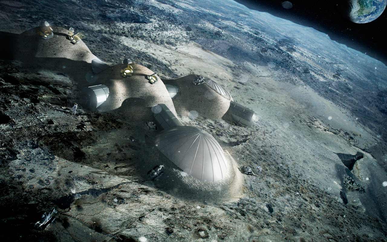
The ESA recently elaborated its plan to create a Moon base by the 2030s. Credit: ESA/Foster+Partners
As Transeth explained back in 2013, this pairing would open up all kinds of possibilities. “We are looking at several alternatives to enable a rover and a robot to work together,” he said. “Since the rover has a powerful energy source, it can provide the snake robot with power through a cable extending between the rover and the robot. If the robot had to use its own batteries, it would run out of power and we would lose it.”
In the configuration Transeth and his colleagues are envisioning, the rover would handle the task of traveling over long distances and then be able to dispatch the snake to crawl into tight inaccessible areas. They would be connected by a cable that would provide electricity, communication signals and would be used to pull the snake back in. In this sense, the snake would act like one of the rover’s arms, but would have the ability to travel autonomously.
“We believe that we can design a robot that can hold on, roll itself up and then extend its body in order to reach new contact points,” said Transeth. “Moreover, we believe that it can creep in among equipment components on the ISS and use equipment surfaces to gain traction in order to keep moving forward – much in the same way as real snakes do in the wild.”
On Mars, sample collection is crucial to many space agency’s research. For the Curiosity rover, the presence of hydrated minerals and clays in soil samples confirmed that Mars once had a warmer, wetter climate. And in the future, scientists hope to find biomakers in Martian soil that could indicate the presence (past or present) of biological life. In this respect, a snake robot would prove very useful since it could access underground recesses the rover cannot.
The sinuous rille known as Rima Ariadaeus, as photographed from Apollo 10, which is the result of a collapsed lava tube. Credit: NASA
On the Moon, snake robots could be especially useful in helping the ESA establish it’s proposed “Moon Village” – a permanent base for scientific activity, tourism and mining that would also act as a successor to the ISS. The most likely location for this base could be within stable lava tubes or subterranean tunnels, which would provide natural shielding from meteors, solar radiation and cosmic rays.
But before such construction of this base can take place, these tunnels and lava tubes will have to be inspected to ensure that they are safe for human habitation. The ESA has also been committed to studying comets in recent years, which included sending the Rosetta space probe and Philae lander to rendezvous with the comet 67P/Tsjurjumov–Gerasimenko in 2014.
Unfortunately, the lander experienced problems when its system of harpoons (designed to hold it in place) failed to deploy. As a result, it was forced to make another soft landing which left it in a position and location that was not optimal for research. In the future, the ESA could get avoid this by sending a probe to the surface that would deploy the snakes to the surface, which could then burrow into the comet’s interior.
But in the meantime, operations aboard the ISS remain the most realistic and likely application for these robots. Here, astronauts are engaged in ongoing scientific experiments, but are also responsible for maintaining the station and all of its equipment. In this latter respect, the SERPEX project could certainly prove useful, providing them with robot helpers that could help with the regular maintenance.
“It’s possible that a robot could carry out some of the routine inspection and maintenance work,” said Transeth. “The experiments are stacked in the shelf sections, behind which corrosion can occur. To find this out, inspections have to be made. A snake robot could creep behind the sections, carry out an inspection, and perhaps even perform small maintenance tasks.”
Some of the concepts developed by SINTEF so far include the Aiko robot, which was developed to produce a portable system for experimenting with snake robot locomotion. The robot consists of several identical joint modules with two motorized degrees of freedom each. As you can see from the video above, it is propelled by contact forces between the robot and the obstacles in its way.
And then there’s the Wheeko robot, which was developed by SINTEF in conjunction with the Center for Interdisciplinary Research in Space (CIRiS), and the Norwegian Space Center (NSC). Much like Aiko, this experimental robot was designed to study snake robot locomotion across flat surfaces. It consists of ten identical joint modules with two motorized degrees of freedom each.
But of course, developing snake robots that can handle various tasks while working in different environments – ranging from working in micro-gravity aboard the ISS to snaking their way through tunnels on a body with gravity – presents many challenges. And in the coming years, Transeth and his colleagues will be looking for ways to address all of them.
“We want to find out what specifications a snake robot system requires,” he said. “For example, what kind of sensors does the robot need to obtain an adequate understand its surroundings? What technologies are available to help us meet these needs, and what new technologies will have to be developed? What uncertainties are involved in terms to what it may be possible to achieve?”
Already, astronauts aboard the ISS have robotic helpers in the form of the Synchronized Position Hold Engage and Reorient Experimental Satellite (SPHERES). These free flying satellites serve as test beds for a diverse range of hardware and software, all of which is critical for future space missions that use distributed spacecraft architecture.
Soon enough, they will be replaced by a drone called Astrobee – a robotic cube packed with sensors, cameras, computers, and a propulsion system. The brainchild of the Ames Research Center’s Intelligent Robotics Group, this drone will be flying around the ISS and making inspections.
Some of the technology used by Astrobee will be similar to what Transeth and his colleague are hoping to apply to their snake robot system. As such, they hope to learn much from this drone’s time aboard the ISS and incorporate the lessons that are learned from it.
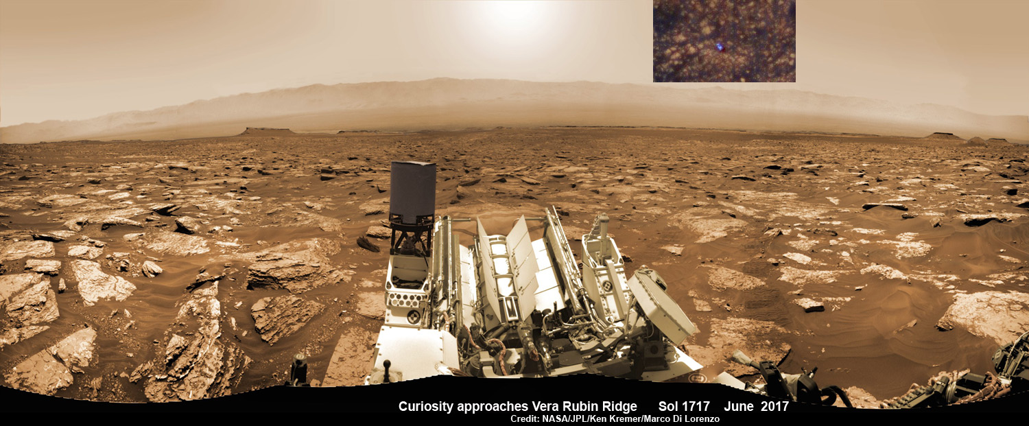
NASA’s Curiosity rover as seen simultaneously on Mars surface and from orbit on Sol 1717, June 5, 2017. The robot snapped this self portrait mosaic view while approaching Vera Rubin Ridge at the base of Mount Sharp inside Gale Crater - backdropped by distant crater rim. This navcam camera mosaic was stitched from raw images and colorized. Inset shows overhead orbital view of Curiosity (blue feature) amid rocky mountainside terrain taken the same day by NASA’s Mars Reconnaissance Orbiter. Credit: NASA/JPL/Ken Kremer/kenkremer.com/Marco Di Lorenzo
NASA’s Curiosity rover as seen simultaneously on Mars surface and from orbit on Sol 1717, June 5, 2017. The robot snapped this self portrait mosaic view while approaching Vera Rubin Ridge at the base of Mount Sharp inside Gale Crater – backdropped by distant crater rim. This navcam camera mosaic was stitched from raw images and colorized. Inset shows overhead orbital view of Curiosity (blue feature) amid rocky mountainside terrain taken the same day by NASA’s Mars Reconnaissance Orbiter. Credit: NASA/JPL/Ken Kremer/kenkremer.com/Marco Di Lorenzo
You can catch a glimpse of what its like to see NASA’s Curiosity Mars rover simultaneously high overhead from orbit and trundling down low across the Red Planet’s rocky surface as she climbs the breathtaking terrain of Mount Sharp – as seen in new images from NASA we have stitched together into a mosaic view showing the perspective views; see above.
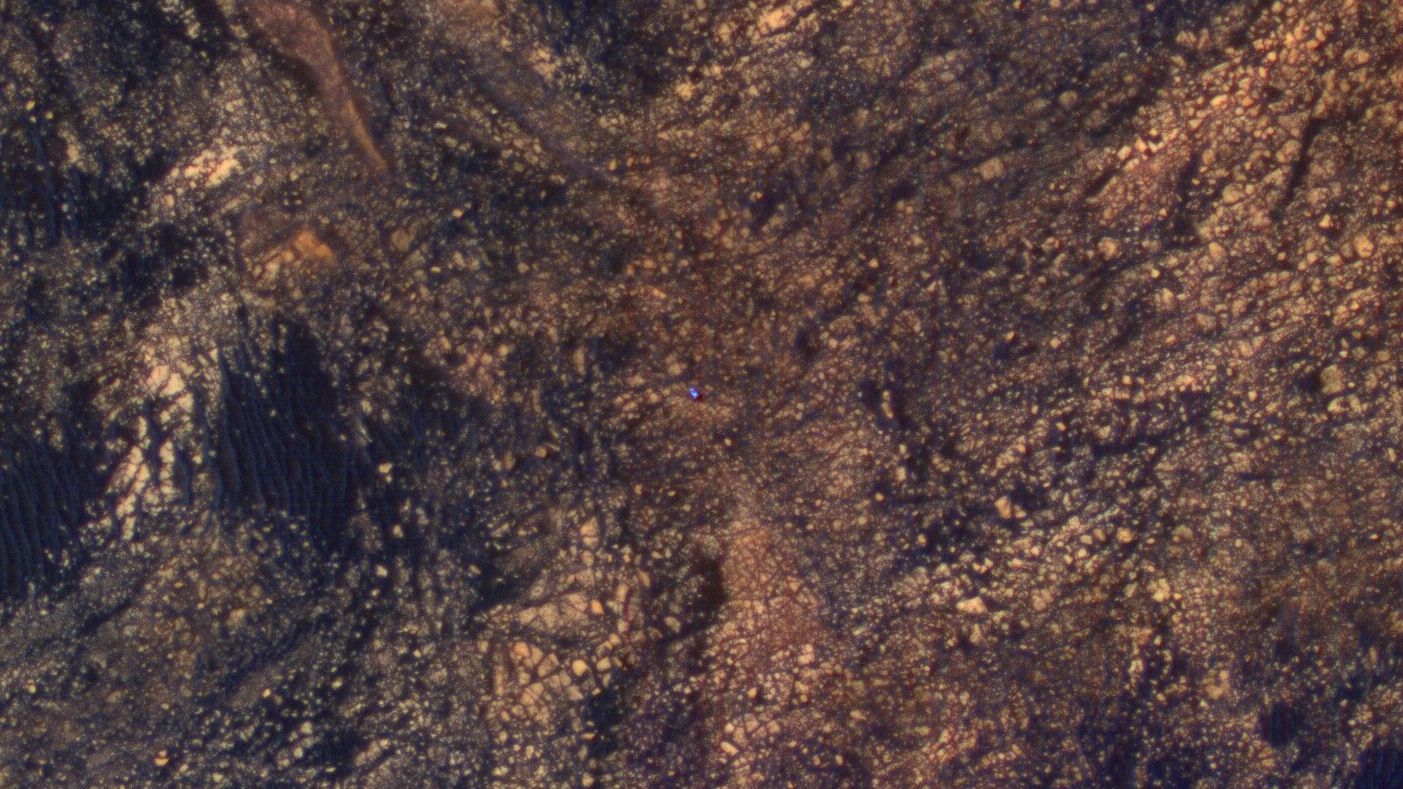
Earlier this month on June 5, researchers commanded NASA’s Mars Reconnaissance Orbiter (MRO) to image the car sized Curiosity rover from Mars orbit using the spacecrafts onboard High Resolution Imaging Science Experiment (HiRISE) telescopic camera during Sol 1717 of her Martian expedition – see below.
HiRISE is the most powerful telescope ever sent to Mars.
And as she does nearly every Sol, or Martian day, Curiosity snapped a batch of new images captured from Mars surface using her navigation camera called navcam – likewise on Sol 1717.
Since NASA just released the high resolution MRO images of Curiosity from orbit, we assembled together the navcam camera raw images taken simultaneously on June 5 (Sol 1717), in order to show the actual vista seen by the six wheeled robot from a surface perspective on the same day.
The lead navcam photo mosaic shows a partial rover selfie backdropped by the distant rim of Gale Crater – and was stitched together by the imaging team of Ken Kremer and Marco Di Lorenzo.
The feature that appears bright blue at the center of this scene is NASA’s Curiosity Mars rover amid tan rocks and dark sand on Mount Sharp, as viewed by the HiRISE camera on NASA’s Mars Reconnaissance Orbiter on June 5, 2017. The rover is about 10 feet long and not really as blue as it looks here. The image was taken as Curiosity was partway between its investigation of active sand dunes lower on Mount Sharp, and “Vera Rubin Ridge,” a destination uphill where the rover team intends to examine outcrops where hematite has been identified from Mars orbit. Credits: NASA/JPL-Caltech/Univ. of Arizona
Right now NASA’s Curiosity Mars Science Laboratory (MSL) rover is approaching her next science destination named “Vera Rubin Ridge” while climbing up the lower reaches of Mount Sharp, the humongous mountain that dominates the rover’s landing site inside Gale Crater.
“When the MRO image was taken, Curiosity was partway between its investigation of active sand dunes lower on Mount Sharp, and “Vera Rubin Ridge,” a destination uphill where the rover team intends to examine outcrops where hematite has been identified from Mars orbit,” says NASA.
“HiRISE has been imaging Curiosity about every three months, to monitor the surrounding features for changes such as dune migration or erosion.”
The MRO image has been color enhanced and shows Curiosity as a bright blue feature. It is currently traveling on the northwestern flank of Mount Sharp. Curiosity is approximately 10 feet long and 9 feet wide (3.0 meters by 2.8 meters).
“The exaggerated color, showing differences in Mars surface materials, makes Curiosity appear bluer than it really looks. This helps make differences in Mars surface materials apparent, but does not show natural color as seen by the human eye.”
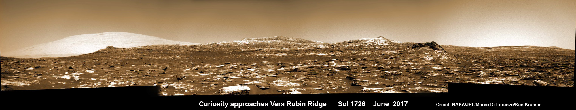
See our mosaic of “Vera Rubin Ridge” and Mount Sharp below.
Curiosity images Vera Rubin Ridge during approach backdropped by Mount Sharp. This navcam camera mosaic was stitched from raw images taken on Sol 1726, June 14, 2017 and colorized. Credit: NASA/JPL/Marco Di Lorenzo/Ken Kremer/kenkremer.com
Curiosity is making rapid progress towards the hematite-bearing location of Vera Rubin Ridge after conducting in-depth exploration of the Bagnold Dunes earlier this year.
“Vera Rubin Ridge is a high-standing unit that runs parallel to and along the eastern side of the Bagnold Dunes,” says Mark Salvatore, an MSL Participating Scientist and a faculty member at Northern Arizona University, in a new mission update.
“From orbit, Vera Rubin Ridge has been shown to exhibit signatures of hematite, an oxidized iron phase whose presence can help us to better understand the environmental conditions present when this mineral assemblage formed.”
Curiosity will use her cameras and spectrometers to elucidate the origin and nature of Vera Rubin Ridge and potential implications or role in past habitable environments.
“The rover will turn its cameras to Vera Rubin Ridge for another suite of high resolution color images, which will help to characterize any observed layers, fractures, or geologic contacts. These observations will help the science team to determine how Vera Rubin Ridge formed and its relationship to the other geologic units found within Gale Crater.”
To reach Vera Rubin Ridge, Curiosity is driving east-northeast around two small patches of dunes just to the north. She will then turn “southeast and towards the location identified as the safest place for Curiosity to ascend the ridge. Currently, this ridge ascent point is approximately 370 meters away.”
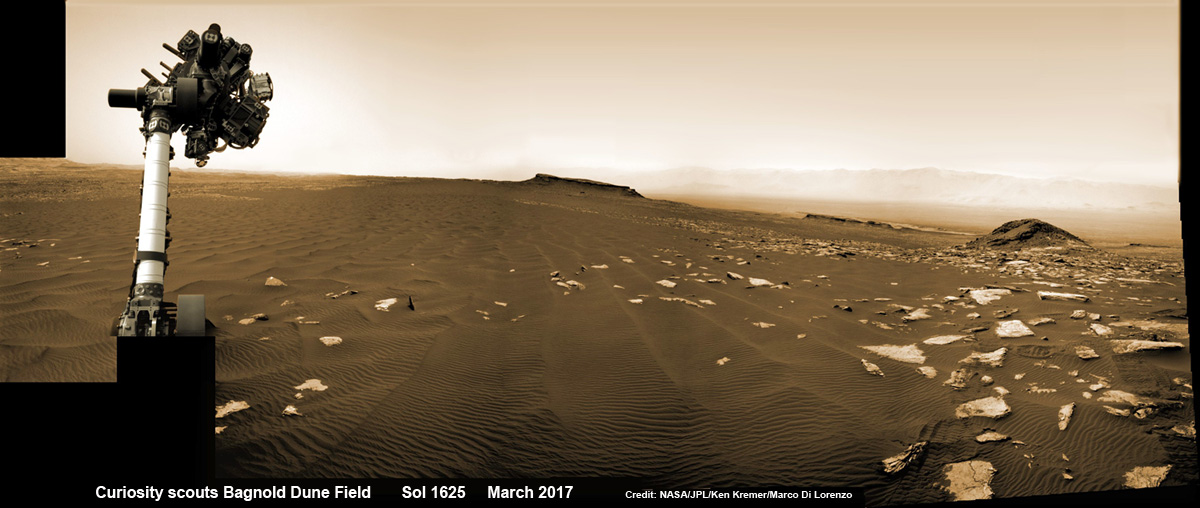
Curiosity rover raises robotic arm high while scouting the Bagnold Dune Field and observing dust devils inside Gale Crater on Mars on Sol 1625, Mar. 2, 2017, in this navcam camera mosaic stitched from raw images and colorized. Note: Wheel tracks at right, distant crater rim in background. Credit: NASA/JPL/Ken Kremer/kenkremer.com/Marco Di Lorenzo
Ascending and diligently exploring the sedimentary lower layers of Mount Sharp, which towers 3.4 miles (5.5 kilometers) into the Martian sky, is the primary destination and goal of the rovers long term scientific expedition on the Red Planet.
“Lower Mount Sharp was chosen as a destination for the Curiosity mission because the layers of the mountain offer exposures of rocks that record environmental conditions from different times in the early history of the Red Planet. Curiosity has found evidence for ancient wet environments that offered conditions favorable for microbial life, if Mars has ever hosted life,” says NASA.
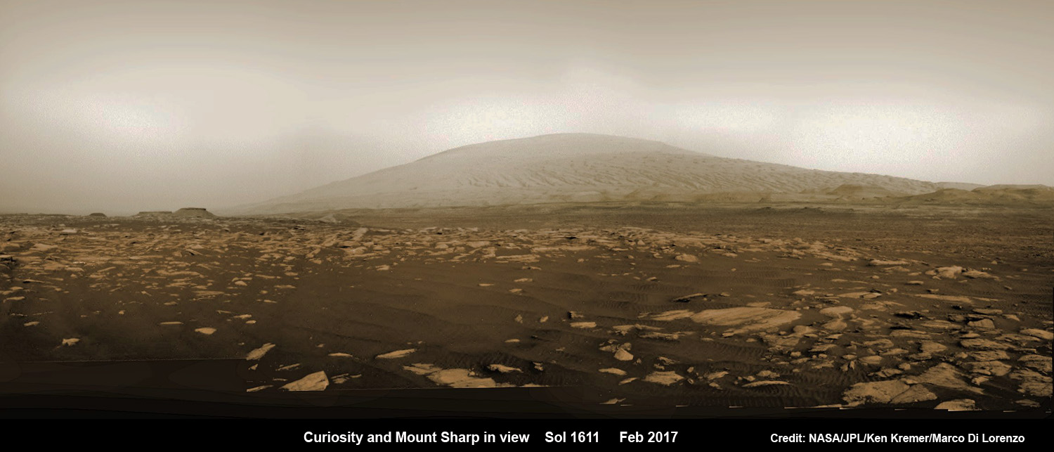
NASA’s Curiosity rover explores sand dunes inside Gale Crater with Mount Sharp in view on Mars on Sol 1611, Feb. 16, 2017, in this navcam camera mosaic, stitched from raw images and colorized. Credit: NASA/JPL/Ken Kremer/kenkremer.com/Marco Di Lorenzo
As of today, Sol 1733, June 21, 2017, Curiosity has driven over 10.29 miles (16.57 kilometers) since its August 2012 landing inside Gale Crater, and taken over 420,000 amazing images.
Stay tuned here for Ken’s continuing Earth and planetary science and human spaceflight news.
Learn more about the upcoming SpaceX launch of BulgariaSat 1, recent SpaceX Dragon CRS-11 resupply launch to ISS, NASA missions and more at Ken’s upcoming outreach events at Kennedy Space Center Quality Inn, Titusville, FL:
June 22-24: “SpaceX BulgariaSat 1 launch, SpaceX CRS-11 and CRS-10 resupply launches to the ISS, Inmarsat 5 and NRO Spysat, EchoStar 23, SLS, Orion, Commercial crew capsules from Boeing and SpaceX , Heroes and Legends at KSCVC, ULA Atlas/John Glenn Cygnus launch to ISS, SBIRS GEO 3 launch, GOES-R weather satellite launch, OSIRIS-Rex, Juno at Jupiter, InSight Mars lander, SpaceX and Orbital ATK cargo missions to the ISS, ULA Delta 4 Heavy spy satellite, Curiosity and Opportunity explore Mars, Pluto and more,” Kennedy Space Center Quality Inn, Titusville, FL, evenings
Curiosity’s Traverse Map Through Sol 1717. This map shows the route driven by NASA’s Mars rover Curiosity through the 1717 Martian day, or sol, of the rover’s mission on Mars (June 05, 2017). The base image from the map is from the High Resolution Imaging Science Experiment Camera (HiRISE) in NASA’s Mars Reconnaissance Orbiter. Credit: NASA/JPL-Caltech/Univ. of Arizona
We’ve spent a few articles on Universe Today talking about just how difficult it’s going to be to travel to other stars. Sending tiny unmanned probes across the vast gulfs between stars is still mostly science fiction. But to send humans on that journey? That’s just a level of technology beyond comprehension.
For example, the nearest star is Proxima Centauri, located a mere 4.25 light years away. Just for comparison, the Voyager spacecraft, the most distant human objects ever built by humans, would need about 50,000 years to make that journey.
I don’t know about you, but I don’t anticipate living 50,000 years. No, we’re going to want to make the journey more quickly. But the problem, of course, is that going more quickly requires more energy, new forms of propulsion we’ve only starting to dream up. And if you go too quickly, mere grains of dust floating through space become incredibly dangerous.
Based on our current technology, it’s more likely that we’re going to have to take our time getting to another star.
And if you’re going to go the slower route, you’ve got a couple of options. Create a generational ship, so that successive generations of humans are born, live out their lives, and then die during the hundreds or even thousands of year long journey to another star.
Artist’s impression of the surface of the planet Proxima b orbiting the red dwarf star Proxima Centauri. The double star Alpha Centauri AB is visible to the upper right of Proxima itself. Credit: ESO
Imagine you’re one of the people destined to live and die, never reaching your destination. Especially when you look out your window and watch a warp ship zip past with all those happy tourists headed to Proxima Centauri, who were start enough to wait for warp drives to be invented.
No, you want to sleep for the journey to the nearest star, so that when you get there, it’s like no time passed. And even if warp drive did get invented while you were asleep, you didn’t have to see their smug tourist faces as they zipped past.
Is human hibernation possible? Can we do it long enough to survive a long-duration spaceflight journey and wake up again on the other side?
Before I get into this, we’re just going to have to assume that we never merge with our robot overlords, upload ourselves into the singularity, and effortlessly travel through space with our cybernetic bodies.
For some reason, that whole singularity thing never worked out, or the robots went on strike and refused to do our space exploration for us any more. And so, the job of space travel fell to us, the fragile, 80-year lifespanned mammals. Exploring the worlds within the Solar System and out to other stars, spreading humanity into the cosmos.
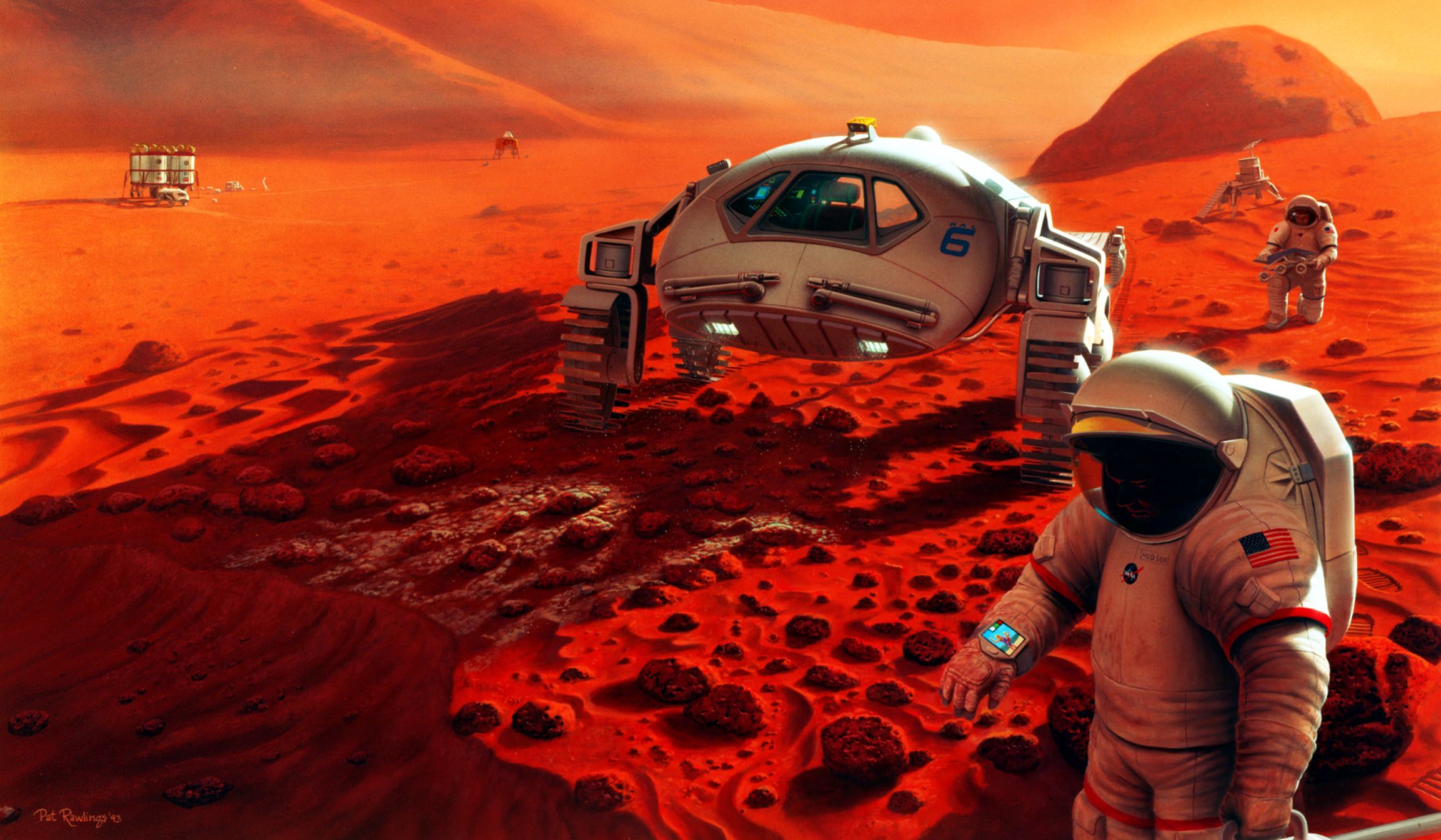
Artist’s impression of astronauts exploring the surface of Mars. Credit: NASA/JSC/Pat Rawlings, SAIC
Come on, we know it’ll totally be the robots. But that’s not what the science fiction tells us, so let’s dig into it.
We see animals, and especially mammals hibernating all the time in nature. In order to be able survive over a harsh winter, animals are capable of slowing their heart rate down to just a few beats a minute. They don’t need to eat or drink, surviving on their fat stores for months at a time until food returns.
It’s not just bears and rodents that can do it, by the way, there are actually a couple of primates, including the fat-tailed dwarf lemur from Madagascar. That’s not too far away on the old family tree, so there might be hope for human hibernation after all.
In fact, medicine is already playing around with human hibernation to improve people’s chances to survive heart attacks and strokes. The current state of this technology is really promising.
They use a technique called therapeutic hypothermia, which lowers the temperature of a person by a few degrees. They can use ice packs or coolers, and doctors have even tried pumping a cooled saline solution through the circulatory system. With the lowered temperature, a human’s metabolism decreases and they fall unconscious into a torpor.
But the trick is to not make them so unconscious that they die. It’s a fine line.
The results have been pretty amazing. People have been kept in this torpor state for up to 14 days, going through multiple cycles.
The therapeutic use of this torpor is still under research, and doctors are learning if it’s helpful for people with heart attacks, strokes or even the progression of diseases like cancer. They’re also trying to figure out if there are any downsides, but so far, there don’t seem to be any long-term problems with putting someone in this torpor state.
A few years ago, SpaceWorks Enterprises delivered a report to NASA on how they could use this therapeutic hypothermia for long duration spaceflight within the Solar System.
Currently, a trip to Mars takes about 6-9 months. And during that time, the human passengers are going to be using up precious air, water and food. But in this torpor state, SpaceWorks estimates that the crew will a reduction in their metabolic rate of 50 to 70%. Less metabolism, less resources needed. Less cargo that needs to be sent to Mars.
Credit: SpaceWork Enterprises, Inc
The astronauts wouldn’t need to move around, so you could keep them nice and snug in little pods for the journey. And they wouldn’t get into fights with each other, after 6-9 months of nothing but day after day of spaceflight.
We know that weightlessness has a negative effect on the body, like loss of bone mass and atrophy of muscles. Normally astronauts exercise for hours every day to counteract the negative effects of the reduced gravity. But SpaceWorks thinks it would be more effective to just put the astronauts into a rotating module and let artificial gravity do the work of maintaining their conditioning.
They envision a module that’s 4 metres high and 8 metres wide. If you spin the habitat at 20 revolutions per minute, you give the crew the equivalent of Earth gravity. Go at only 11.8 RPM and it’ll feel like Mars gravity. Down to 7.8 and it’s lunar gravity.
Normally spinning that fast in a habitat that small would be extremely uncomfortable as the crew would experience different forces at different parts of their body. But remember, they’ll be in a state of torpor, so they really won’t care.
Credit: SpaceWork Enterprises, Inc
Current plans for sending colonists to Mars would require 40 ton habitats to support 6 people on the trip. But according to SpaceWorks, you could reduce the weight down to 15 tons if you just let them sleep their way through the journey. And the savings get even better with more astronauts.
The crew probably wouldn’t all sleep for the entire journey. Instead, they’d sleep in shifts for a few weeks. Taking turns to wake up, check on the status of the spacecraft and crew before returning to their cryosleep caskets.
What’s the status of this now? NASA funded stage 1 of the SpaceWorks proposal, and in July, 2016 NASA moved forward with Phase 2 of the project, which will further investigate this technique for Mars missions, and how it could be used even farther out in the Solar System.
Elon Musk should be interested in seeing their designs for a 100-person module for sending colonists to Mars.
Credit: SpaceWork Enterprises, Inc
In addition, the European Space Agency has also been investigating human hibernation, and a possible way to enable long-duration spaceflight. They have plans to test out the technology on various non-hibernating mammals, like pigs. If their results are positive, we might see the Europeans pushing this technology forward.
Can we go further, putting people to sleep for decades and maybe even the centuries it would take to travel between the stars?
Right now, the answer is no. We don’t have any technology at our disposal that could do this. We know that microbial life can be frozen for hundreds of years. Right now there are parts of Siberia unfreezing after centuries of permafrost, awakening ancient microbes, viruses, plants and even animals. But nothing on the scale of human beings.
When humans freeze, ice crystals form in our cells, rupturing them permanently. There is one line of research that offers some hope: cryogenics. This process replaces the fluids of the human body with an antifreeze agent which doesn’t form the same destructive crystals.
Scientists have successfully frozen and then unfrozen 50-milliliters (almost a quarter cup) of tissue without any damage.
In the next few years, we’ll probably see this technology expanded to preserving organs for transplant, and eventually entire bodies, and maybe even humans. Then this science fiction idea might actually turn into reality. We’ll finally be able to sleep our way between the stars.
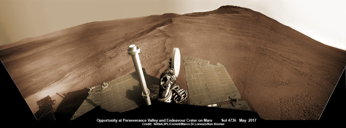
Opportunity rover looks south from the top of Perseverance Valley along the rim of Endeavour Crater on Mars in this partial self portrait including the rover deck and solar panels. Perseverance Valley descends from the right and terminates down near the crater floor. This navcam camera photo mosaic was assembled from raw images taken on Sol 4736 (20 May 2017) and colorized. Credit: NASA/JPL/Cornell/Marco Di Lorenzo/Ken Kremer/kenkremer.com
Opportunity rover looks south from the top of Perseverance Valley along the rim of Endeavour Crater on Mars in this partial self portrait including the rover deck and solar panels. Perseverance Valley descends from the right and terminates down near the crater floor. This navcam camera photo mosaic was assembled from raw images taken on Sol 4736 (20 May 2017) and colorized. Credit: NASA/JPL/Cornell/Marco Di Lorenzo/Ken Kremer/kenkremer.com
Now well into her 13th year roving the Red Planet, NASA’s astoundingly resilient Opportunity rover has arrived at the precipice of “Perseverance Valley” – overlooking the upper end of an ancient fluid-carved valley on Mars “possibly water-cut” that flows down into the unimaginably vast eeriness of alien Endeavour crater.
In a remarkable first time feat and treat for having ‘persevered’ so long on the inhospitably frigid Martian terrain, Opportunity has been tasked by her human handlers to drive down a Martian gully carved billions of years ago – by a fluid that might have been water – and conduct unparalleled scientific exploration, that will also extend into the interior of Endeavour Crater for the first time.
No Mars rover has done that before.
“This will be the first time we will acquire ground truth on a gully system that just might be formed by fluvial processes,” Ray Arvidson, Opportunity Deputy Principal Investigator of Washington University in St. Louis, told Universe Today.
“Opportunity has arrived at the head of Perseverance Valley, a possible water-cut valley here at a low spot along the rim of the 22-km diameter Endeavour impact crater,” says Larry Crumpler, a rover science team member from the New Mexico Museum of Natural History & Science.
“The next month or so will be an exciting time, for no rover has ever driven down a potential ancient water-cut valley before,” Crumpler gushes.
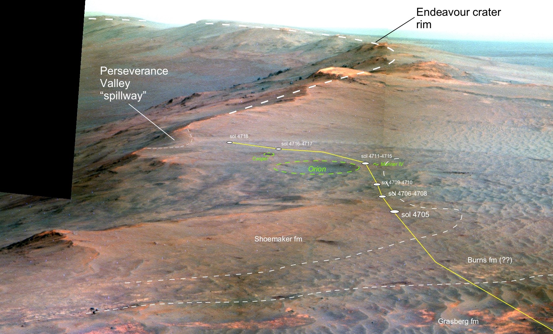
“Perseverance Valley” is located along the eroded western rim of gigantic Endeavour crater – as illustrated by our exclusive photo mosaics herein created by the imaging team of Ken Kremer and Marco Di Lorenzo.
The mosaics show the “spillway” as the entry point to the ancient valley.
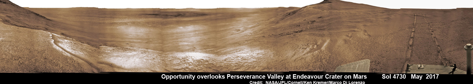
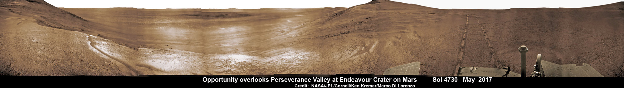
NASA’s Opportunity rover acquired this Martian panoramic view from a promontory that overlooks Perseverance Valley below – scanning from north to south. It is centered on due East and into the interior of Endeavour crater. Perseverance Valley descends from the right and terminates down near the crater floor in the center of the panorama. The far rim of Endeavour crater is seen in the distance, beyond the dark floor. Rover deck and wheel tracks at right. This navcam camera photo mosaic was assembled from raw images taken on Sol 4730 (14 May 2017) and colorized. Credit: NASA/JPL/Cornell/Ken Kremer/kenkremer.com/Marco Di Lorenzo
“Investigations in the coming weeks will “endeavor” to determine whether this valley was eroded by water or some other dry process like debris flows,” explains Crumpler.
“It certainly looks like a water cut valley. But looks aren’t good enough. We need additional evidence to test that idea.”
The valley slices downward from the crest line through the rim from west to east at a breathtaking slope of about 15 to 17 degrees – and measures about two football fields in length!
Huge Endeavour crater spans some 22 kilometers (14 miles) in diameter on the Red Planet. Perseverance Valley slices eastwards at approximately the 8 o’clock position of the circular shaped crater. It sits just north of a rim segment called “Cape Byron.”
Why go and explore the gully at Perseverance Valley?
“Opportunity will traverse to the head of the gully system [at Perseverance] and head downhill into one or more of the gullies to characterize the morphology and search for evidence of deposits,” Arvidson elaborated.
“Hopefully test among dry mass movements, debris flow, and fluvial processes for gully formation. The importance is that this will be the first time we will acquire ground truth on a gully system that just might be formed by fluvial processes. Will search for cross bedding, gravel beds, fining or coarsening upward sequences, etc., to test among hypotheses.”
Perspective view of Opportunity’s traverse along Endeavour crater rim over the last few weeks towards the Perseverance Valley “spillway” on Mars during Spring 2017. The entry point for the planned drive back into the crater is visible as the low notch just to the left (east) of the current (sol 4718) rover position. Credit: NASA/JPL/Cornell/NMMNH /Larry Crumpler
Exploring the ancient valley is the main science destination of the current two-year extended mission (EM #10) for the teenaged robot, that officially began Oct. 1, 2016. It’s just the latest in a series of extensions going back to the end of Opportunity’s prime mission in April 2004.
What are the immediate tasks ahead that Opportunity must accomplish before descending down the gully to thoroughly and efficiently investigate the research objectives?
In a nutshell, extensive imaging from a local high point promontory to create a long-baseline 3 D stereo image of the valley and a “walk-about” to assess the local geology.
The rover is collecting images from two widely separated points at a dip at the valley spillway to build an “extraordinarily detailed three-dimensional analysis of the terrain” called a digital elevation map.
“Opportunity has been working on a panorama from the overlook for the past couple of sols. The idea is to get a good overview of the valley from a high point before driving down it,” Crumpler explains.
“But before we drive down the valley, we want to get a good sense of the geologic features here on the head of the valley. It could come in handy as we drive down the valley and may help us understand some things, particularly the lithology of any materials we find on the valley floor or at the terminus down near the crater floor.”
“So we will be doing a short “walk-about” here on the outside of the crater rim near the “spillway” into the valley.”
“We will drive down it to further assess its origin and to further explore the structure and stratigraphy of this large impact crater.”
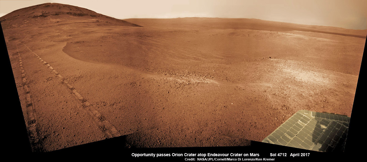
NASA’s Opportunity Mars rover passed near this small, 90-foot-wide and relatively fresh crater in April 2017, during the 45th anniversary of the Apollo 16 mission to the moon. The rover team chose to call it “Orion Crater,” after the Apollo 16 lunar module, Orion, which carried astronauts John Young and Charles Duke to and from the surface of the moon in April 1972 while crewmate Ken Mattingly piloted the Apollo 16 command module, Casper, in orbit around the moon. The rover’s Navigation Camera (Navcam) recorded this view assembled from raw images taken on Sol 4712 (26 April 2017) and colorized. Credit: NASA/JPL/Cornell/Marco Di Lorenzo/Ken Kremer/kenkremer.com
The six wheeled rover landed on Mars on January 24, 2004 PST on the alien Martian plains at Meridiani Planum – as the second half of a stupendous sister act.
Expected to last just 3 months or 90 days, Opportunity has now endured nearly 13 ½ years or an unfathomable 53 times beyond the “warrantied” design lifetime.
Her twin sister Spirit, had successfully touched down 3 weeks earlier on January 3, 2004 inside 100-mile-wide Gusev crater and survived more than six years.
Opportunity has been exploring Endeavour almost six years – since arriving at the humongous crater in 2011. Endeavour crater was formed when it was carved out of the Red Planet by a huge meteor impact billions of years ago.
“Endeavour crater dates from the earliest Martian geologic history, a time when water was abundant and erosion was relatively rapid and somewhat Earth-like,” explains Crumpler.
Exactly what the geologic process was that carved Perseverance Valley into the rim of Endeavour Crater billions of years ago has not yet been determined, but there are a wide range of options researchers are considering.
“Among the possibilities: It might have been flowing water, or might have been a debris flow in which a small amount of water lubricated a turbulent mix of mud and boulders, or might have been an even drier process, such as wind erosion,” say NASA scientists.
“The mission’s main objective with Opportunity at this site is to assess which possibility is best supported by the evidence still in place.”
Extensive imaging with the mast mounted pancam and navcam cameras is currently in progress.
“The long-baseline stereo imaging will be used to generate a digital elevation map that will help the team carefully evaluate possible driving routes down the valley before starting the descent,” said Opportunity Project Manager John Callas of JPL, in a statement.
“Reversing course back uphill when partway down could be difficult, so finding a path with minimum obstacles will be important for driving Opportunity through the whole valley. Researchers intend to use the rover to examine textures and compositions at the top, throughout the length and at the bottom, as part of investigating the valley’s history.”
The team is also dealing with a new wheel issue and evaluating fixes. The left-front wheel is stuck due to an actuator stall.
“The rover experienced a left-front wheel steering actuator stall on Sol 4750 (June 4, 2017) leaving the wheel ‘toed-out’ by 33 degrees,” the team reported in a new update.
Thus the extensive Pancam panorama is humorously being called the “Sprained Ankle Panorama.” Selected high-value targets of the surrounding area will be imaged with the full 13-filter Pancam suite.
After reaching the bottom of Perseverance Valley, Opportunity will explore the craters interior for the first time during the mission.
“Once down at the end of the valley, Opportunity will be directed to explore the crater fill on a drive south at the foot of the crater walls,” states Crumpler.
As of today, June 17, 2017, long lived Opportunity has survived over 4763 Sols (or Martian days) roving the harsh environment of the Red Planet.
Opportunity has taken over 220,800 images and traversed over 27.87 miles (44.86 kilometers) – more than a marathon.
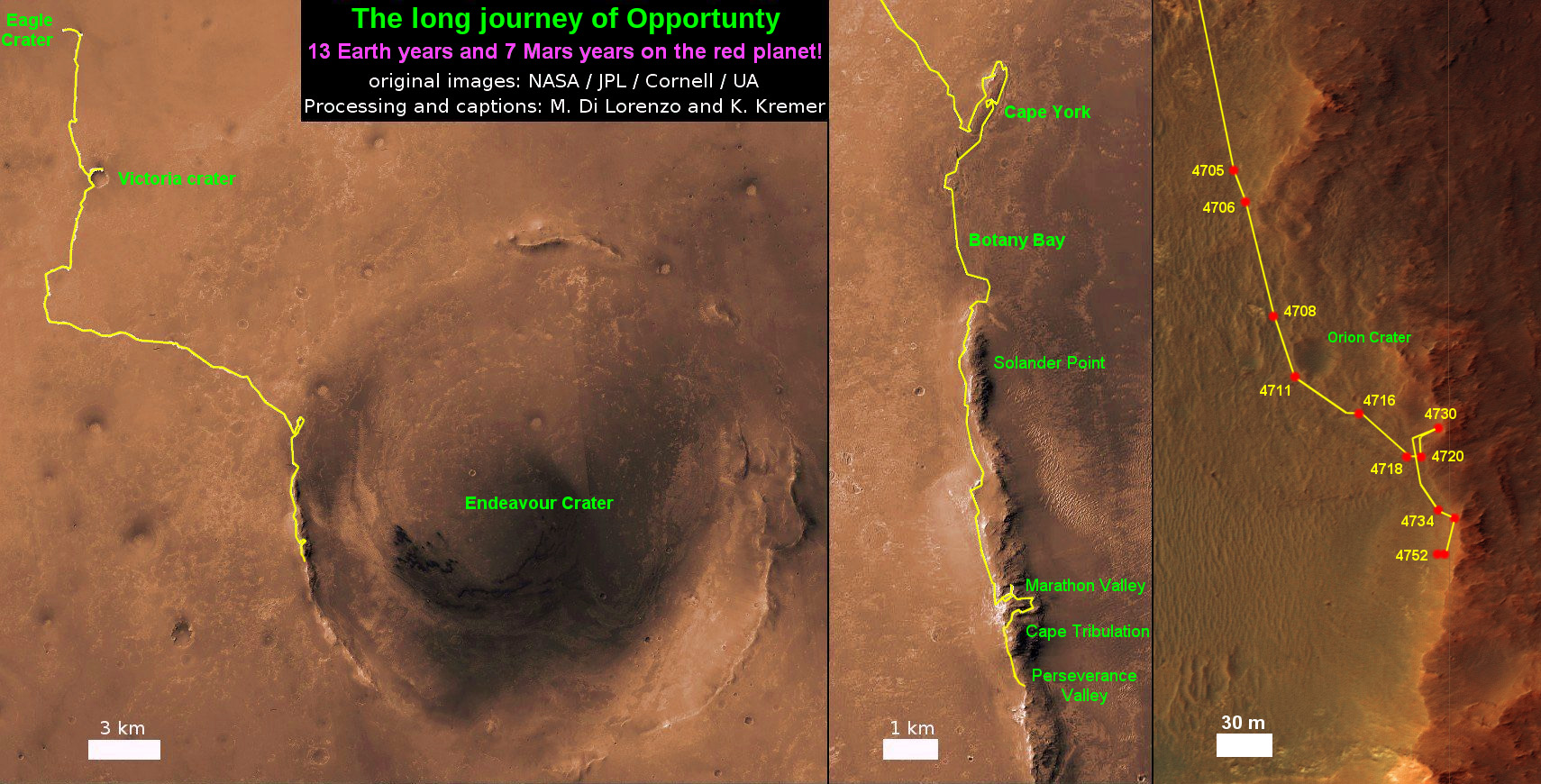
See our updated route map below. It shows the context of the rovers over 13 year long traverse spanning more than the 26 mile distance of a Marathon runners race.
The rover surpassed the 27 mile mark milestone on November 6, 2016 (Sol 4546).
NASA’s Opportunity rover acquired this Martian panoramic view from a promontory that overlooks Perseverance Valley below – scanning from north to south. It is centered on due East and into the interior of Endeavour crater. Perseverance Valley descends from the right and terminates down near the crater floor in the center of the panorama. The far rim of Endeavour crater is seen in the distance, beyond the dark floor. Rover deck and wheel tracks at right. This navcam camera photo mosaic was assembled from raw images taken on Sol 4730 (14 May 2017) and colorized. Credit: NASA/JPL/Cornell/Ken Kremer/kenkremer.com/Marco Di Lorenzo
As of Sol 4759 (June 13, 2017) the power output from solar array energy production is currently 343 watt-hours with an atmospheric opacity (Tau) of 0.842 and a solar array dust factor of 0.529, before heading into another southern hemisphere Martian winter later in 2017. It will count as Opportunity’s 8th winter on Mars.
“The science team is really jazzed at starting to see this area up close and looking for clues to help us distinguish among multiple hypotheses about how the valley formed,” said Opportunity Project Scientist Matt Golombek of NASA’s Jet Propulsion Laboratory, Pasadena, California.
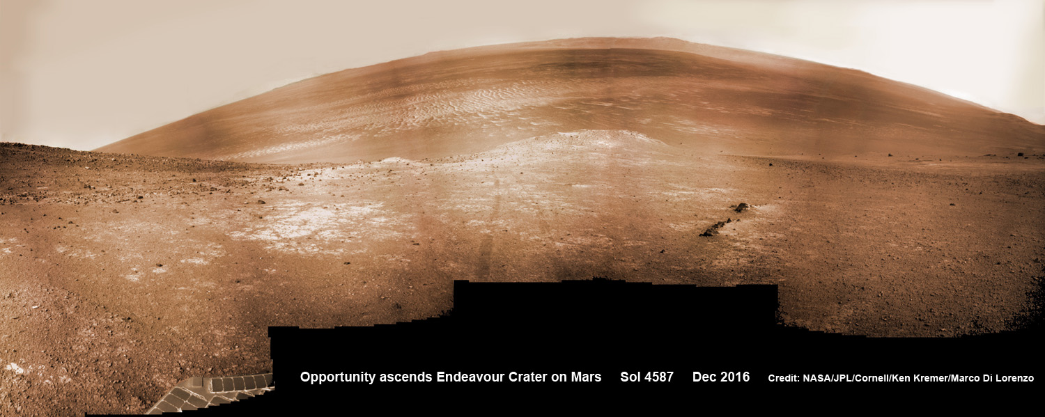
NASA’s Opportunity rover scans around and across to vast Endeavour crater on Dec. 19, 2016, as she climbs steep slopes on the way to reach a water carved gully along the eroded craters western rim. Note rover wheel tracks at center. This navcam camera photo mosaic was assembled from raw images taken on Sol 4587 (19 Dec. 2016) and colorized. Credit: NASA/JPL/Cornell/Ken Kremer/kenkremer.com/Marco Di Lorenzo
Meanwhile Opportunity’s younger sister rover Curiosity traverses and drills into the lower sedimentary layers at the base of Mount Sharp.
And NASA continues building the next two robotic missions due to touch down in 2018 and 2020.
13 Year Traverse Map for NASA’s Opportunity rover from 2004 to 2017. This map shows the entire 44 kilometer (27 mi) path the rover has driven on the Red Planet during over 13 years and more than a marathon runners distance for over 4763 Sols, or Martian days, since landing inside Eagle Crater on Jan 24, 2004 – to current location at the western rim of Endeavour Crater at the head of Perseverance Valley. After studying Spirit Mound and ascending back uphill the rover has reached her next destination in May 2017- the Martian water carved gully at Perseverance Valley near Orion crater. Rover surpassed Marathon distance on Sol 3968 after reaching 11th Martian anniversary on Sol 3911. Opportunity discovered clay minerals at Esperance – indicative of a habitable zone – and searched for more at Marathon Valley. Credit: NASA/JPL/Cornell/ASU/Marco Di Lorenzo/Ken Kremer/kenkremer.com
Stay tuned here for Ken’s continuing Earth and planetary science and human spaceflight news.
Learn more about the Opportunity rover and upcoming SpaceX launch of BulgariaSat 1, recent SpaceX Dragon CRS-11 resupply launch to ISS, NASA missions and more at Ken’s upcoming outreach events at Kennedy Space Center Quality Inn, Titusville, FL:
June 17-19: “Opportunity Mars rover, SpaceX BulgariaSat 1 launch, SpaceX CRS-11 and CRS-10 resupply launches to the ISS, Inmarsat 5 and NRO Spysat, EchoStar 23, SLS, Orion, Commercial crew capsules from Boeing and SpaceX , Heroes and Legends at KSCVC, ULA Atlas/John Glenn Cygnus launch to ISS, SBIRS GEO 3 launch, GOES-R weather satellite launch, OSIRIS-Rex, Juno at Jupiter, InSight Mars lander, SpaceX and Orbital ATK cargo missions to the ISS, ULA Delta 4 Heavy spy satellite, Curiosity explores Mars, Pluto and more,” Kennedy Space Center Quality Inn, Titusville, FL, evenings
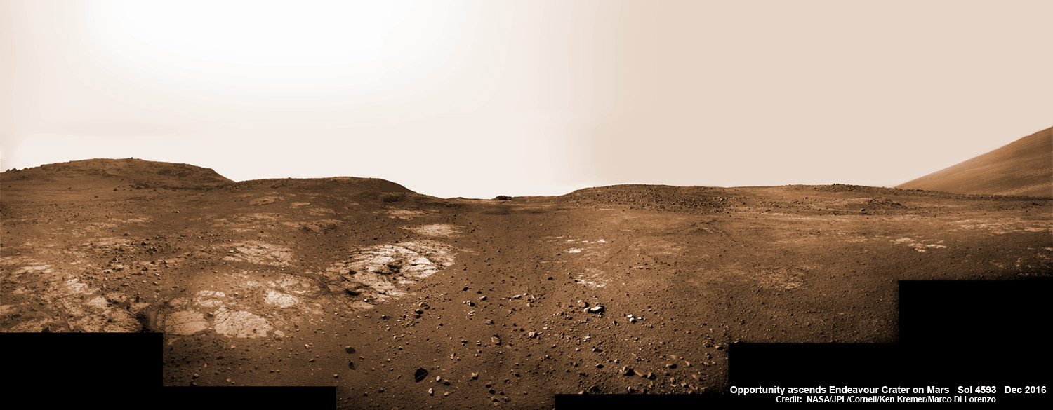
This graphic shows the route that NASA’s Mars Exploration Rover Opportunity drove in its final approach to “Perseverance Valley” on the western rim of Endeavour Crater during spring 2017. Credits: NASA/JPL-Caltech/Univ. of Arizona/NMMNH13 Years on Mars! On Christmas Day 2016, NASA’s Opportunity rover scans around vast Endeavour crater as she ascends steep rocky slopes on the way to reach a water carved gully along the eroded craters western rim. This navcam camera photo mosaic was assembled from raw images taken on Sol 4593 (25 Dec. 2016) and colorized. Credit: NASA/JPL/Cornell/Ken Kremer/kenkremer.com/Marco Di Lorenzo
Welcome, come in to the 513th Carnival of Space! The Carnival is a community of space science and astronomy writers and bloggers, who submit their best work each week for your benefit. I’m Susie Murph, part of the team at Universe Today and CosmoQuest. So now, on to this week’s stories! Continue reading “Carnival of Space #513”
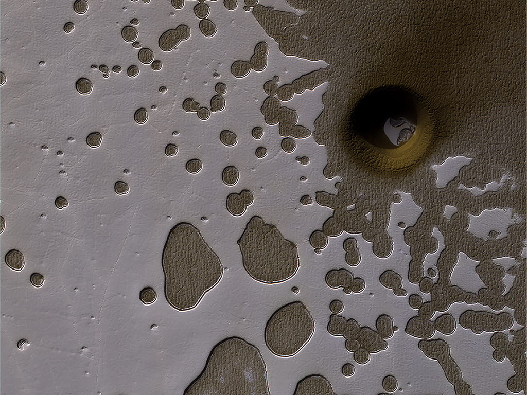
The HiRISE camera on NASA's Mars Reconnaissance Orbiter captured this unusual crater or pit on the surface of Mars. Frozen carbon dioxide gives the region its unique "Swiss cheese" like appearance. Image:NASA/JPL/University of Arizona
The HiRISE camera on NASA’s Mars Reconnaissance Orbiter captured this unusual crater or pit on the surface of Mars. Frozen carbon dioxide gives the region its unique “Swiss cheese” like appearance. Image:NASA/JPL/University of Arizona
During late summer in the Southern hemisphere on Mars, the angle of the sunlight as it strikes the surface brings out some subtle details on the planet’s surface.
In this image, the HiRISE camera on board NASA’s Mars Reconnaissance Orbiter (MRO) captured an area of frozen carbon dioxide on the surface. Some of the carbon dioxide ice has melted, giving it a swiss-cheese appearance. But there is also an unusual hole or crater on the right side of the image, with some of the carbon dioxide ice clearly visible in the bottom of the pit.
NASA scientists are uncertain what exactly caused the unusual pit. It could be an impact crater, or it could be a collapsed pit caused by melting or sublimation of sub-surface carbon dioxide ice.
MRO has been in orbit around Mars for over 10 years, and has completed over 50,000 orbits. The MRO has two cameras. The CTX camera is lower resolution, and has imaged over 99% of the Martian surface. HiRISE is the high-resolution camera that is used to closely examine areas and objects of interest, like the unusual surface pit in this image.
A new study from UNLV indicates that the health risks for astronauts exploring Mars could be twice as bad as previously thought. Credit: NASA/Pat Rawlings, SAIC
Astronauts hoping to take part in a crewed mission to Mars might want to pack some additional rad tablets! Long before NASA announced their proposal for a “Journey to Mars“, which envisions putting boots on the Red Planet by the 2030s, mission planners have been aware that one of the greatest risks for such a mission has to do with the threat posed by cosmic and solar radiation.
But according to a new study from the University of Nevada, Las Vegas, this threat is even worse than previously thought. Using a predictive model, this study indicates that astronauts that are the surface of Mars for extended periods of time could experience cell damage from cosmic rays, and that this damage will extend to other healthy cells – effectively doubling the risk of cancer!
At one time, Mars had a magnetic field similar to Earth, which prevented its atmosphere from being stripped away. Credit: NASA
Galactic cosmic rays (GCRs) are one of the greatest hazards posed by space exploration. These particles, which originate from beyond our Solar System, are basically atomic nuclei that have been stripped of their surrounding electrons, thanks to their high-speed journey through space. In the cases of iron and titanium atoms, these have been known to cause heavy damage to cells because of their very high rates of ionization.
Here on Earth, we are protected from these rays and other sources of radiation thanks to our protective magnetosphere. But with missions that would take astronauts well beyond Earth, they become a much greater threat. And given the long-term nature of a mission to Mars, mitigation procedures and shielding are being investigated quite thoroughly. As Cucinotta explained in a UNLV press statement:
“Exploring Mars will require missions of 900 days or longer and includes more than one year in deep space where exposures to all energies of galactic cosmic ray heavy ions are unavoidable. Current levels of radiation shielding would, at best, modestly decrease the exposure risks.”
Previous studies have indicated that the effects of prolonged exposure to cosmic rays include cancer, central nervous system effects, cataracts, circulatory diseases and acute radiation syndromes. However, until now, the damage these rays cause was thought to be confined to those cells that they actually traverse – which was based on models that deal with the targeted effects of radiation.
Artist’s impression of astronauts exploring the surface of Mars. Credit: NASA/JSC/Pat Rawlings, SAIC
For the sake of their study, Dr. Cucinotta and Dr. Eliedonna Cacao (a Chemical Engineer at UNLV) consulted the mouse Harderian gland tumor experiment. This is the only extensive data-set to date that deals with the non-targeted effects (NTEs) of radiation for a variety of particles. Using this model, they tracked the effects of chronic exposure to GCRs, and determined that the risks would be twice as high as those predicted by targeted effects models.
“Galactic cosmic ray exposure can devastate a cell’s nucleus and cause mutations that can result in cancers,” Cucinotta explained. “We learned the damaged cells send signals to the surrounding, unaffected cells and likely modify the tissues’ microenvironments. Those signals seem to inspire the healthy cells to mutate, thereby causing additional tumors or cancers.”
Naturally, any indication that there could be an elevated risk calls for additional research. As Cucinotta and Cacao indicated in their study, “The scarcity of data with animal models for tissues that dominate human radiation cancer risk, including lung, colon, breast, liver, and stomach, suggest that studies of NTEs in other tissues are urgently needed prior to long-term space missions outside the protection of the Earth’s geomagnetic sphere.”
These studies will of course need to happen before any long-term space missions are mounted beyond Earth’s magnetosphere. In addition, the findings also raise undeniable ethical issues, such as whether or not these risks could (or should) be waived by space agencies and astronauts. If in fact we cannot mitigate or protect against the hazards associated with long-term missions, is it even right to ask or allow astronauts to take part in them?
In the meantime, NASA may want to have another look at the mission components for the Journey to Mars, and maybe contemplate adding an additional layer or two of lead shielding. Better to be prepared for the worst, right?
Compared to a regular human, the Earth is enormous. And compared to the Earth, the Universe is really enormous. Like, maybe infinitely enormous.
And yet, Earth is the only place humans are allowed to own. You can buy a plot of land in the city or the country, but you can’t buy land on the Moon, on Mars or on Alpha Centauri.
It’s not that someone wouldn’t be willing to sell it to you. I could point you at a few locations on the internet where someone would be glad to exchange your “Earth money” for some property rights on the Moon. But I can also point you to a series of United Nations resolutions which clearly states that outer space should be free for everyone. Not even the worst rocky outcrop of Maxwell Montes on Venus, or the bottom of Valles Marineris on Mars can be bought or sold.
However, the ability to own property is one of the drivers of the modern economy. Most people either own land, or want to own land. And if humans do finally become a space faring civilization, somebody is going to want to own the property rights to chunks of space. They’re going to want the mining rights to extract resources from asteroids and comets.
We’re going to want to know, once and for all, can I buy the Moon?
Until the space age, the question was purely hypothetical. It was like asking if you could own dragons, or secure the mining rights to dreams. Just in case those become possible, my vote to both is no.
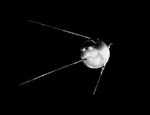
The Sputnik spacecraft stunned the world when it was launched into orbit on Oct. 4th, 1954. Credit: NASA
But when the first satellite was placed into orbit in 1957, things became a lot less hypothetical. Once multiple nations had reached orbitable capabilities, it became clear that some rules needed to be figured out – the Outer Space Treaty.
The first version of the treaty was signed by the US, Soviet Union and the United Kingdom back in 1967. They were mostly concerned with preventing the militarization of space. You’re not allowed to put nuclear weapons into space, you’re not allowed to detonate nuclear weapons on other planets. Seriously, if you’ve got plans and they relate to nuclear weapons, just, don’t.
Can’t kill killer asteroids with nukes. Credit: Los Alamos National Lab
Over the years, almost the entire world has signed onto the Outer Space Treaty. 106 countries are parties and another 24 have signed on, but haven’t fully ratified it yet.
In addition to all those nuclear weapons rules, the United Nations agreed on several other rules. In fact, its full name is, The Treaty on Principles Governing the Activities of States in the Exploration and Use of Outer Space, including the Moon and Other Celestial Bodies.
Here’s the relevant language:
Outer space, including the moon and other celestial bodies, is not subject to national appropriation by claim of sovereignty, by means of use or occupation, or by any other means.
No country can own the Moon. No country can own Jupiter. No country can own a tiny planet, off in the corner of the Andromeda Galaxy. And no citizens or companies from those countries can own any property either.
And so far, no country has tried to. Seriously, space exploration is incredibly difficult. We’ve only set foot on the Moon a couple of times, decades ago, and never returned.
But with all the recent developments, it looks like we might be getting closer to wondering if we can own dragons, or a nice acreage on Mars.
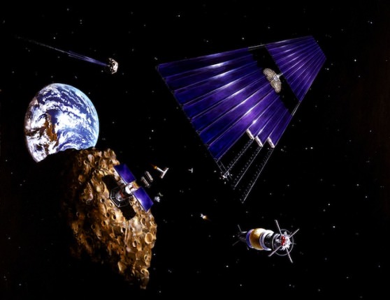
Perhaps the most interesting recent development is the creation of not one, not two, but three companies dedicated to mining resources from asteroids: Planetary Resources, Kepler Energy, and Deep Space Industries.
Just a single small asteroid could contain many useful minerals, and there could potentially be tens of billions of dollars in profit for anyone who can sink robotic mining shafts into them.
Asteroid mining concept. Credit: NASA/Denise Watt
The three different companies have their own plans on how they’re going to identify potential mining targets and extract resources, and I’m not going to go into all the details of what it would take to mine an asteroid in this video.
But according to the Outer Space Treaty, is it legal? The answer, is: probably.
The original treaty was actually pretty vague. It said that no country can claim sovereignty over a world in space, but that doesn’t mean we can’t utilize some of its resources. In fact, future missions to the Moon and Mars depend on astronauts “living off the land”, harvesting local resources like ice to make air, drinking water and rocket fuel. Or building structures out of Martian regolith.
Mining an entire asteroid for sweet sweet profit is just a difference of scale.
In order to provide some clarity, the United States passed the U.S. Commercial Space Launch Competitiveness Act of 2015. This gave details on how space tourism should work, and described how companies might mine minerals from space. The gist of the law is, if an American citizen can get their hands on materials from an asteroid, they own it, and they’re free to sell it.
The Interplanetary Transport System blasting off. Credit: SpaceX
As you know, SpaceX is planning to colonize Mars. Well, so far, their plans include building the most powerful rocket ever built, and hurling human beings at Mars, hundreds at a time. The first mission is expected to blast off in 2024, so this is quickly becoming a practical issue.
What are the legalities of colonizing Mars? Will you own a chunk of land when you stumble out of the Interplanetary Transport Ship out on the surface of Mars?
Right now, you can imagine the surface of Mars like a research station on Antarctica. If SpaceX, an American company, builds a colony on Mars, then it’s essentially US government property. Anything that happens within that colony is under the laws of the United States.
If a group of colonists from China, for example, set out on their own, they would be building a little piece of China. And no matter what kind of facility they build, nobody within the team actually owns their homes.
If you’re out on the surface, away from a base, everything reverts to international law. Watch out for space pirates!
The space pirates were everywhere. Monday suddenly got a lot more interesting. Credit: NASA/JSC/Pat Rawlings, SAIC
Under the treaty, every facility is obliged to provide access to anyone else out there, which means that members of one facility are free to visit any other facility. You can’t lock your door and keep anyone out.
In fact, if anyone’s in trouble, you’re legally bound to do everything you can (within reason) to lend your assistance.
The bottom line is that the current Outer Space Treaty is not exactly prepared for the future reality of the colonization of Mars. As more and more people reach the Red Planet, you’d expect they’re going to want to govern themselves. We’ve seen this play out time and time again on Earth, so it won’t be surprising when the Mars colonies band together to declare their separation from Earth.
That said, as long as they’re reliant on regular supplies from Earth, they won’t be able to fully declare their independence. As long as they have interests on Earth, our planet’s governments will be able to squeeze them and maintain their dominance.
Credit: NASA
Once a Mars colony is fully self sufficient, though, which Elon Musk estimates will occur by 1 million inhabitants, Earth will have to recognize a fully independent Mars.
Space law is going to be one of the most interesting aspects of the future of space exploration. It’s really the next frontier. Concepts which were purely theoretical are becoming more and more concrete, and lawyers will finally be the heroes we always knew they could be.
If you’ve always wanted to be an astronaut, but your parents have always wanted you to be a lawyer, now’s your chance to do both. An astronaut space lawyer. I’m just saying, it’s an option.
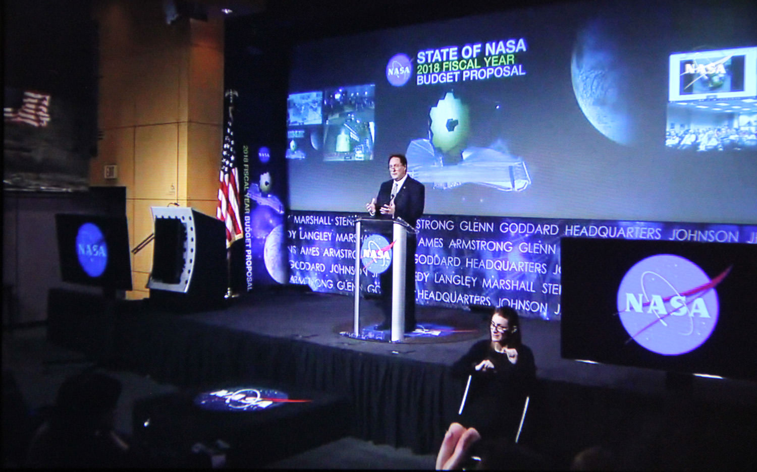
NASA acting administrator Robert Lightfoot outlines NASA’s Fiscal Year 2018 budget proposal during a ‘State of NASA’ speech to agency employees held at NASA HQ on May 23, 2017. Credit: NASA TV/Ken Kremer
NASA acting administrator Robert Lightfoot outlines NASA’s Fiscal Year 2018 budget proposal during a ‘State of NASA’ speech to agency employees held at NASA HQ on May 23, 2017. Credit: NASA TV/Ken Kremer
The Trump Administration has proposed a $19.1 Billion NASA budget request for Fiscal Year 2018, which amounts to a $0.5 Billion reduction compared to the recently enacted FY 2017 NASA Budget. Although it maintains many programs such as human spaceflight, planetary science and the Webb telescope, the budget also specifies significant cuts and terminations to NASA’s Earth Science and manned Asteroid redirect mission as well as the complete elimination of the Education Office.
Overall NASA’s FY 2018 budget is cut approximately 3%, or $560 million, for the upcoming fiscal year starting in October 2017 as part of the Trump Administration’s US Federal Budget proposal rolled out on May 23, and quite similar to the initial outline released in March.
The cuts to NASA are smaller compared to other Federal science agencies also absolutely vital to the health of US scientific research – such as the NIH, the NSF, the EPA, DOE and NIST which suffer unconscionable double digit slashes of 10 to 20% or more.
The highlights of NASA’s FY 2018 Budget were announced by NASA acting administrator Robert Lightfoot during a ‘State of NASA’ speech to agency employees held at NASA HQ, Washington, D.C. and broadcast to the public live on NASA TV.
Lightfoot’s message to NASA and space enthusiasts was upbeat overall.
“What this budget tells us to do is to keep going!” NASA acting administrator Robert Lightfoot said.
“Keep doing what we’ve been doing. It’s very important for us to maintain that course and move forward as an agency with all the great things we’re doing.”
“I want to reiterate how proud I am of all of you for your hard work – which is making a real difference around the world. NASA is leading the world in space exploration, and that is only possible through all of your efforts, every day.”
“We’re pleased by our top line number of $19.1 billion, which reflects the President’s confidence in our direction and the importance of everything we’ve been achieving.”
Thus Lightfoot’s vision for NASA has three great purposes – Discover, Explore, and Develop.
“NASA has a historic and enduring purpose. It can be summarized in three major strategic thrusts: Discover, Explore, and Develop. These correspond to our missions of scientific discovery, missions of exploration, and missions of new technology development in aeronautics and space systems.”
“We’ve had a horizon goal for some time now of reaching Mars, and this budget sustains that work and also provides the resources to keep exploring our solar system and look beyond it.”
Lightfoot also pointed to upcoming near term science missions- highlighting a pair of Mars landers – InSIGHT launching next year as well as the Mars 2020 rover. Also NASA’s next great astronomical observatory – the James Webb Space Telescope (JWST).
“In science, this budget supports approximately 100 missions: 40 missions currently preparing for launch & 60 operating missions.”
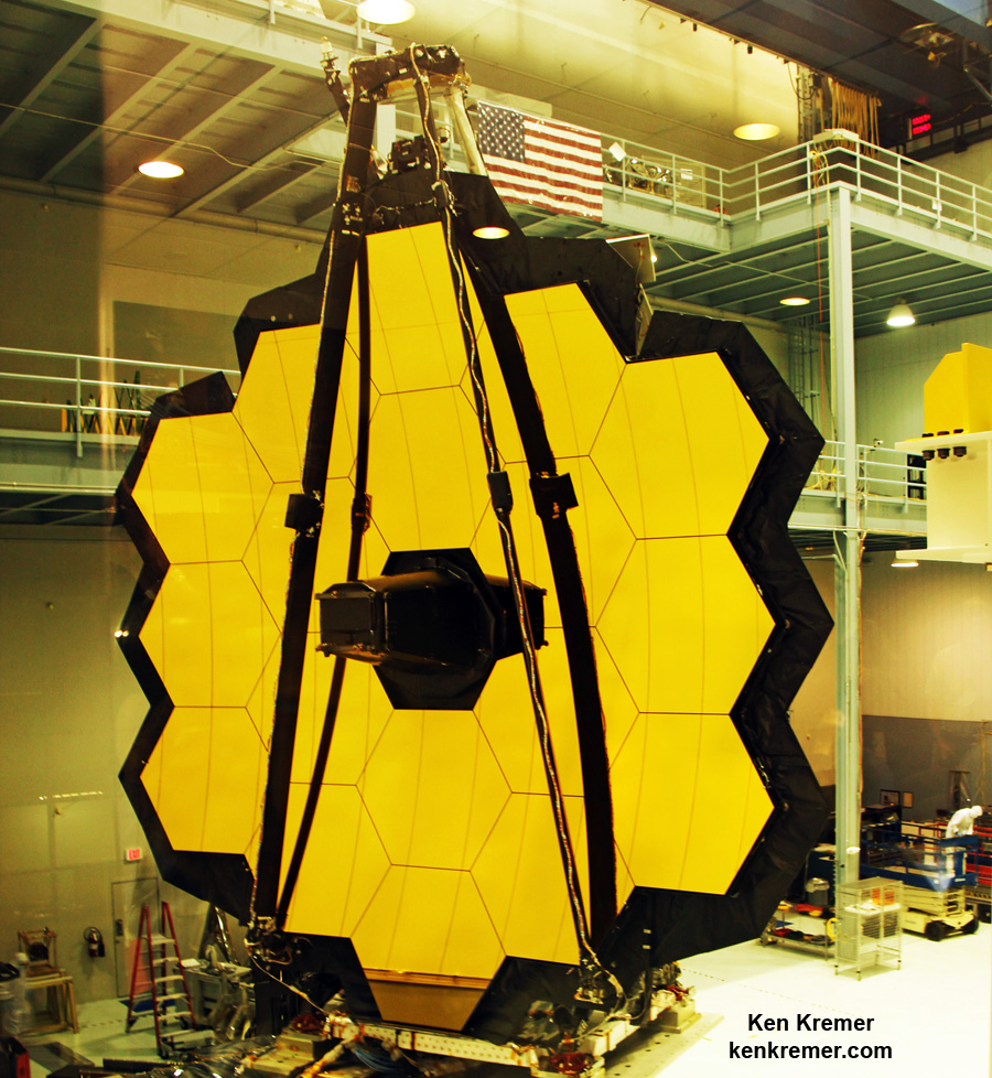
“The James Webb Space Telescope is built!” Lightfoot gleefully announced.
“It’s done testing at Goddard and now has moved to Johnson for tests to simulate the vacuum of space.”
JWST is the scientific successor to the Hubble Space Telescope and slated for launch in Oct. 2018. The budget maintains steady support for Webb.
The 18-segment gold coated primary mirror of NASA’s James Webb Space Telescope is raised into vertical alignment in the largest clean room at the agency’s Goddard Space Flight Center in Greenbelt, Maryland, on Nov. 2, 2016. The secondary mirror mount booms are folded down into stowed for launch configuration. Credit: Ken Kremer/kenkremer.com
The Planetary Sciences division receives excellent support with a $1.9 Billion budget request. It includes solid support for the two flagship missions – Mars 2020 and Europa Clipper as well as the two new Discovery class missions selected -Lucy and Psyche.
“The budget keeps us on track for the next selection for the New Frontiers program, and includes formulation of a mission to Jupiter’s moon Europa.”
“SLS and Orion are making great progress. They are far beyond concepts, and as I mentioned, components are being tested in multiple ways right now as we move toward the first flight of that integrated system.”
NASA is currently targeting the first integrated launch of SLS and Orion on the uncrewed Exploration Mission-1 (EM-1) for sometime in 2019.
NASA would have needed an additional $600 to $900 to upgrade EM-1 with humans.
Unfortunately Trump’s FY 2018 NASA budget calls for a slight reduction in development funding for both SLS and Orion – thus making a crewed EM-1 flight fiscally unviable.
The newly assembled first liquid hydrogen tank, also called the qualification test article, for NASA’s new Space Launch System (SLS) heavy lift rocket lies horizontally beside the Vertical Assembly Center robotic weld machine (blue) on July 22, 2016. It was lifted out of the welder (top) after final welding was just completed at NASA’s Michoud Assembly Facility in New Orleans. Credit: Ken Kremer/kenkremer.com
The budget request does maintain full funding for both of NASA’s commercial crew vehicles planned to restore launching astronauts to low Earth orbit (LEO) and the ISS from US soil on US rockets – namely the crewed Dragon and CST-100 Starliner – currently under development by SpaceX and Boeing – thus ending our sole reliance on Russian Soyuz for manned launches.
“Working with commercial partners, NASA will fly astronauts from American soil on the first new crew transportation systems in a generation in the next couple of years.”
“We need commercial partners to succeed in low-Earth orbit, and we also need the SLS and Orion to take us deeper into space than ever before.”
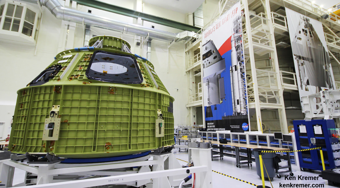
Orion crew module pressure vessel for NASA’s Exploration Mission-1 (EM-1) is unveiled for the first time on Feb. 3, 2016 after arrival at the agency’s Kennedy Space Center (KSC) in Florida. It is secured for processing in a test stand called the birdcage in the high bay inside the Neil Armstrong Operations and Checkout (O&C) Building at KSC. Launch to the Moon is slated in 2018 atop the SLS rocket. Credit: Ken Kremer/kenkremer.com
However the Trump Administration has terminated NASA’s somewhat controversial plans for the Asteroid Redirect Mission (ARM) – initiated under the Obama Administration – to robotically retrieve a near Earth asteroid and redirect it to lunar orbit for a visit by a crewed Orion to gather unique asteroidal samples.
“While we are ending formulation of a mission to an asteroid, known as the Asteroid Redirect Mission, many of the central technologies in development for that mission will continue, as they constitute vital capabilities needed for future human deep space missions.”
Key among those vital capabilities to be retained and funded going forward is Solar Electric Propulsion (SEP).
“Solar electric propulsion (SEP) for our deep space missions is moving ahead as a key lynchpin.”
The Trump Administration’s well known dislike for Earth science and disdain of climate change has manifested itself in the form of the termination of 5 current and upcoming science missions.
NASA’s FY 2018 Earth Science budget suffers a $171 million cut to $1.8 Billion.
“While we are not proposing to move forward with Orbiting Carbon Observatory-3 (OCO-3), Plankton, Aerosol, Cloud, ocean Ecosystem (PACE), Climate Absolute Radiance and Refractivity Observatory Pathfinder (CLARREO PF), and the Radiation Budget Instrument (RBI), this budget still includes significant Earth Science efforts, including 18 Earth observing missions in space as well as airborne missions.”
The DSCOVR Earth-viewing instruments will also be shut down.
NASA’s Office of Education will also be terminated completely under the proposed FY 2018 budget and the $115 million of funding excised.
“While this budget no longer supports the formal Office of Education, NASA will continue to inspire the next generation through its missions and the many ways that our work excites and encourages discovery by learners and educators. Let me tell you, we are as committed to inspiring the next generation as ever.”
Congress will now have its say and a number of Senators, including Republicans says Trumps budget is DOA.
Stay tuned here for Ken’s continuing Earth and Planetary science and human spaceflight news.