This image is a mosaic of all the images captured by the Context Camera (CTX) on NASA's Mars Reconnaissance Orbiter. The CTX has imaged over 99% of the Martian surface. Image: NASA/JPL-Caltech/MSSS
Most of us never do one thing 50,000 times in our life. So for NASA’s Mars Reconnaissance Orbiter (MRO), completing 50,000 orbits around the red planet is a big deal. And, it only took 10 years to do so.
The MRO could be called one of NASA’s flagship missions. It’s presence in orbit around Mars has helped open up our understanding of that planet immensely. And it’s done so while providing us a steady stream of eye candy.
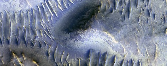
This recent image from MRO’s HiRise camera shows dune structure inside an impact crater. Image: NASA/JPL/University of Arizona
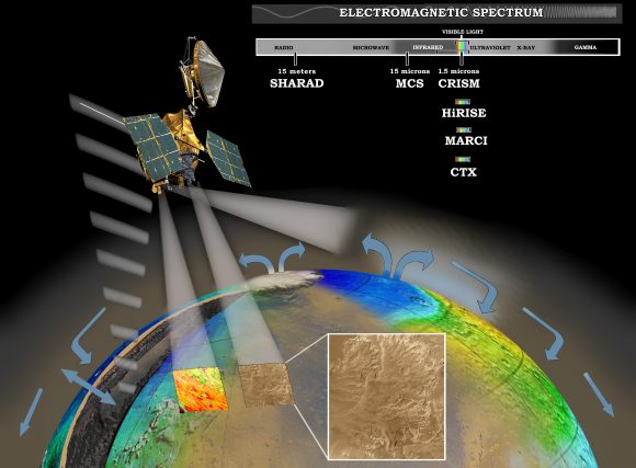
MRO was launched in 2005 and reached Mars orbit in March, 2006. After 10 years at work, it has accomplished a lot. In a recent press release, NASA calls the MRO “the most data-productive spacecraft yet.” Though most of us might know the orbiter because of it’s camera, the High-Resolution Imaging Science Experiment (HiRise), the MRO actually has a handful of other instruments that help the orbiter achieve its objectives. In broad terms, those objectives are:
to study the history of water on Mars
to look at small scale features on the surface, and identify landing sites for future Mars missions
to act as a communications relay between Mars and Earth
MRO investigating Martian water cycle – This artist’s concept represents the “Follow the Water” theme of NASA’s Mars Reconnaissance Orbiter mission. The orbiter’s science instruments monitor the present water cycle in the Mars atmosphere and the associated deposition and sublimation of water ice on the surface, while probing the subsurface to see how deep the water-ice reservoir extends. Image: By NASA/JPL/Corby Waste – http://photojournal.jpl.nasa.gov/catalog/PIA07241 (image link), Public Domain, https://commons.wikimedia.org/w/index.php?curid=374810 (Larger image here.
MRO’s HiRise camera gets all the glory, but it’s another onboard camera, the Context Camera (CTX), that is the real workhorse. The CTX is a much lower resolution than the HiRise, but its file sizes are much more manageable, an important consideration when every file has to travel from Mars to Earth—an average distance of about 225 million km.
CTX has captured 90,000 images so far in MRO’s mission, and each one captures details smaller than a tennis court. In the course of the mission so far, CTX has images that cover 99.1% of the Martian surface. Over 60% of the planet has been covered twice.
“Reaching 99.1-percent coverage has been tricky…” – Context Camera Team Leader Michael Malin
“Reaching 99.1-percent coverage has been tricky because a number of factors, including weather conditions, coordination with other instruments, downlink limitations, and orbital constraints, tend to limit where we can image and when,” said Context Camera Team Leader Michael Malin of Malin Space Science Systems, San Diego.
Malin said, “Single coverage provides a baseline we can use for comparison with future observations, as we look for changes. Re-imaging areas serves two functions: looking for changes and acquiring stereoscopic views from which we can make topographic maps.”
Because the CTX captures image of the same surface areas twice, it documents changes on the surface. There have been over 200 instances of impact craters appearing in a second image of the same area. Scientists have used this to calculate the rate that meteorites impact Mars.
The instruments on board the MRO work as a team. The CTX can capture images of areas of interest, and the HiRise can be used for higher-resolution images of the same area. By locating fresh impact craters, then studying them more closely, the MRO has helped discover the presence of what looked like sub-surface ice on Mars. A third instrument, the Compact Reconnaissance Imaging Spectrometer for Mars (CRISM), confirmed the presence of ice.
The CTX is the workhorse camera, and the HiRise is the diva, but MRO actually has a third camera: the Mars Color Imager (MARCI). MARCI is a very low resolution camera compared to the others. It’s also a wide-angle camera with really only one purpose: characterizing Martian weather. Every day, MARCI takes about 84 images which together create a daily global map of Mars. You can see a weekly Martian weather report from MARCI here.
The MRO recently manoeuvered itself into position for its next task—helping the InSight Lander. The MRO must receive critical radio transmissions from NASA’s InSight Lander as it descends to Mars. Insight will use its instruments to examine the interior of Mars for clues to how rocky planets form. Not only did MRO help find a landing spot for Insight, but it will hold the lander’s hand as it descends, and it will act as a data relay.
“After 11 and a half years in flight, the spacecraft is healthy and remains fully functional.” – MRO Project Manager Dan Johnston.
There’s no end in sight for the MRO. It just keeps going and going, and fulfilling its mission objectives on a continuing basis. “After 11 and a half years in flight, the spacecraft is healthy and remains fully functional,” said MRO Project Manager Dan Johnston at NASA’s Jet Propulsion Laboratory, Pasadena, California. “It’s a marvelous vehicle that we expect will serve the Mars Exploration Program and Mars science for many more years to come.”
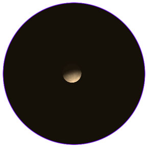
Mercury requests the company of your gaze now through the beginning of April, when it shines near Mars low in the west after sunset. Created with Stellarium
March has been a busy month for planet and comet watchers. Lots of action. Venus, the planet that’s captured our attention at dusk in the west for months, is in inferior conjunction with the Sun today. Watch for it to rise before the Sun in the eastern sky at dawn in about a week.
Mercury like Venus and the Moon shows phases when viewed through a telescope. Right now, the planet is in waning gibbous phase. Stellarium
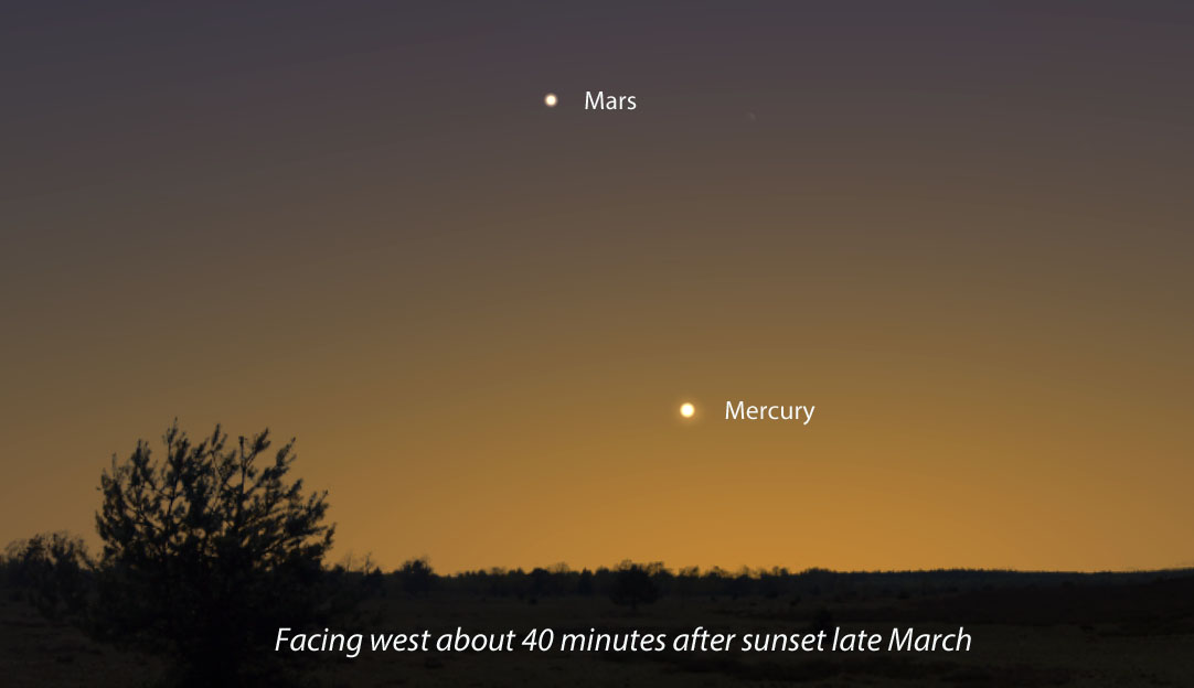
As Venus flees the evening scene, steadfast Mars and a new planet, Mercury keep things lively. For northern hemisphere skywatchers, this is Mercury’s best dusk apparition of the year. If you’d like to make its acquaintance, this week and next are best. And it’s so easy! Just find a spot with a wide open view of the western horizon, bring a pair of binoculars for backup and wait for a clear evening.
Plan to watch starting about 40 minutes after sundown. From most locations, Mercury will appear about 10° or one fist held at arm’s length above the horizon a little bit north of due west. Shining around magnitude +0, it will be the only “star” in that part of the sky. Mars is nearby but much fainter at magnitude +1.5. You’ll have to wait at least an hour after sunset to spot it.
Have a telescope? Check out the planet using a magnification around 50x or higher. You’ll see that it looks like a Mini-Me version of the Moon. Mercury is brightest when closest to full. Over the next few weeks, it will wane to a crescent while increasing in apparent size.
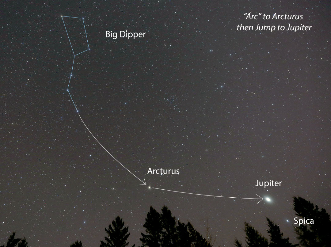
If you have any difficulty finding brilliant Jupiter and its current pal, Spica, just start with the Big Dipper, now high in the northeastern sky at nightfall. Use the Dipper’s handle to “arc to Arcturus” and then “jump to Jupiter.” Credit: Bob King
If you like planets, don’t forget the combo of Jupiter and Spica at the opposite end of the sky. Jupiter climbs out of bed and over the southeastern horizon about 9 p.m. local time in late March, but to see it and Spica, Virgo’s brightest star, give it an hour and look again at 10 p.m. or later. Quite the duo!
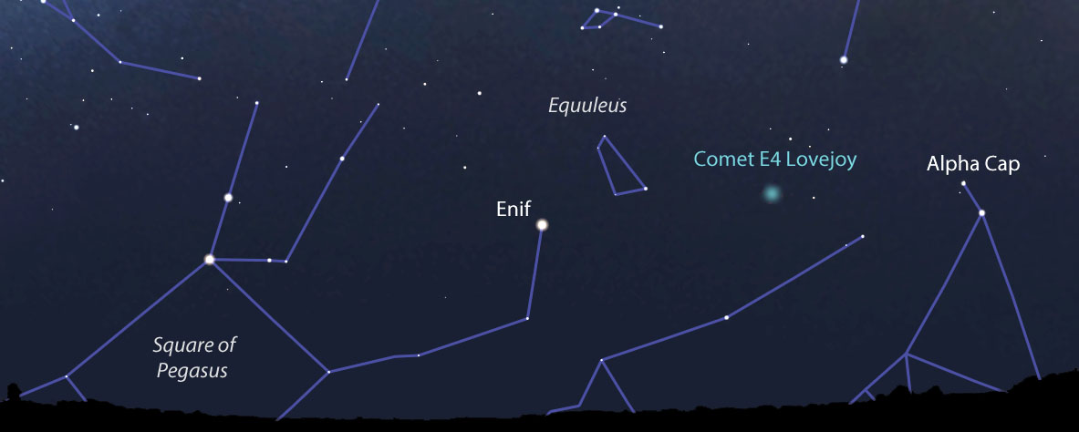
You’re not afraid of getting up with the first robins are you? If you set your alarm to a half hour or so before the first hint of dawn’s light and find a location with an open view of the southeastern horizon, you might be first in your neighborhood to spot Terry Lovejoy’s brand new comet. His sixth, the Australian amateur discovered C/2017 E4 Lovejoyon the morning of March 10th in the constellation Sagittarius at about 12th magnitude.
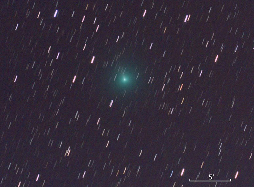
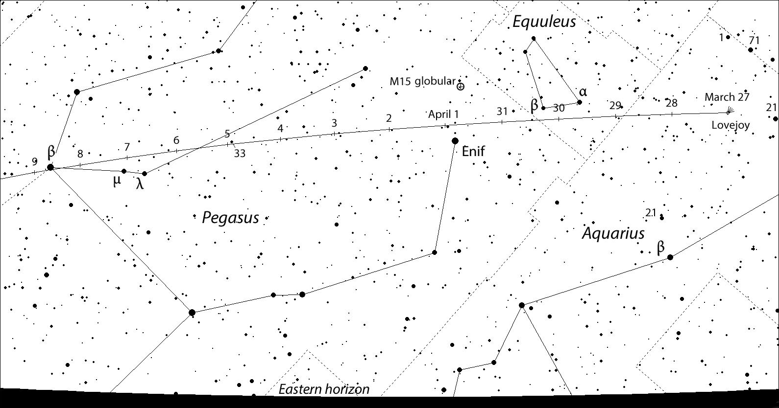
C/2017 E4 Lovejoy glows blue-green this morning March 26. Structure around the nucleus including a small jet is visible. The comet is currently in Aquarius and quickly moving north and will reach perihelion on April 23. Credit: Terry Lovejoy
The comet has rapidly brightened since then and is now a small, moderately condensed fuzzball of magnitude +9, bright enough to spot in a 6-inch or larger telescope. Some observers have even picked it up in large binoculars. Lovejoy’s comet should brighten by at least another magnitude in the coming weeks, putting it within 10 x 50 binocular range.
This map shows the sky tomorrow morning before dawn from the central U.S. (latitude about 41° north). Created with Stellarium
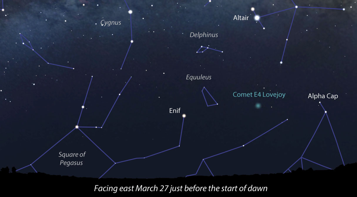
Good news. E4 Lovejoy is moving north rapidly and is now visible about a dozen degrees high in Aquarius just before the start of dawn. I’ll be out the next clear morning, eyepiece to eye, to welcome this new fuzzball from beyond Neptune to my front yard. The map above shows the eastern sky near dawn and a general location of the comet. Use the more detailed map below to pinpoint it in your binoculars and telescope.
This chart shows the comet’s position nightly (5:30 a.m. CDT) through April 9. On the morning of April 1 it passes just a few degrees below the bright globular cluster M15. Click to enlarge, save and then print out for use at the telescope. Map: Bob King, Source: Chris Marriott’s SkyMap
Spring brings with it a new spirit and the opportunity to get out at night free of the bite of mosquitos or cold. Clear skies!
Mars, as photographed with the Mars Global Surveyor, is identified with the Roman god of war. Credit: NASA
This week, from March 20th to 24th, the 48th Lunar and Planetary Science Conference will be taking place in The Woodlands, Texas. Every year, this conference brings together international specialists in the fields of geology, geochemistry, geophysics, and astronomy to present the latest findings in planetary science. One of the highlights of the conference so far has been a presentation about Mars’ weather patterns.
When it comes to cloud formations, gravity waves are the result of gravity trying to restore them to their natural equilibrium. And while common on Earth, such formation were not thought to be possible around Mars’ equatorial band, where the gravity waves were seen. All of this was made possible thanks to Curiosity’s advantageous position inside the Gale Crater.
Panoramic image showing cirrus clouds in the Martian atmosphere, taken by the Opportunity rover in 2006. Credit: NASA/JPL/Cornell/M. Howard, T. Öner, D, Bouic & M. Di Lorenzo
Located near Mars’ equator, Curiosity has managed to consistently record what is known as the Aphelion Cloud Belt (ACB). As the name would suggest, this annually-recurring phenomena appears during the aphelion season on Mars (when it is farthest from the Sun) between the latitudes of 10°S and 30°N. During aphelion, the point farthest from the Sun, the planet is dominated by two cloud systems.
These include the aforementioned ACB, and the polar phenomena known as Polar Hood Clouds (PHCs). Whereas PHCs are characterized by clouds of carbon dioxide, clouds that form around Mars’ equatorial band are made up water-ice. These cloud systems them dissipate as Mars gets closer to the Sun (perihelion), where increases in temperature lead to the creation of dust storms that limit cloud formation.
During the nearly five years that Curiosity has been operational, the rover has recorded over 500 movies of the equatorial Martian sky. These movies have taken the form of both Zenith Movies (ZMs) – which involve the camera being pointed vertically – and Supra-Horizon Movies (SHM), which were aimed at a lower angle of elevation to keep the horizon in frame.
Using Curiosity’s navigation camera, Jacob Kloos and Dr. John Moores – two researchers from CRESS – made eight recordings of the ACB over the course of two Martian years – specifically between Mars Years 31 and Mars Years 33 (ca. 2012 to 2016). By comparing ZM and SHM movies, they were able to discern changes in the clouds that were both diurnal (daily) and annual in nature.
What they found was that between 2015 and 2016, Mars’ ACB underwent changes in opacity (aka. changes in density) during its diurnal cycle. After periods of enhanced early morning activity, the clouds would reach a minimum by late morning. This is followed by a second, lower peak in the late afternoon, which indicated that Mars’ early morning hours are the most favorable time for the formation of thicker clouds.
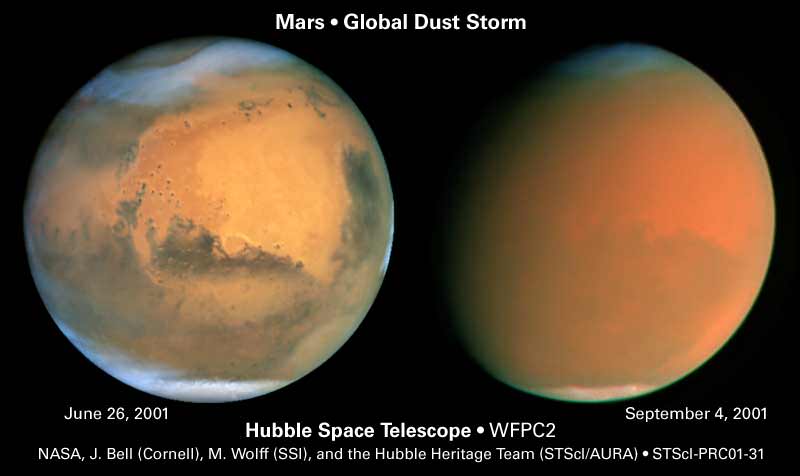
Hubble images show cloud formations (left) and the effects of a global dust storm on Mars. Credit: NASA/James Bell (Cornell Univ.), Michael Wolff (Space Science Inst.), and Hubble Heritage Team (STScI/AURA)
As for inter-annual variability, they found that between 2012 and 2016, when Mars moved away from aphelion, there was a corresponding 38% increase in the number of higher-opacity clouds. However, believing these results to be the result of a statistical bias caused by an uneven distribution of videos, they concluded that the difference in opacity was more along the lines of about 5%.
These variations were all of this is consistent with tidal temperature variations, where cooler daytime or seasonal temperatures result in greater levels of condensation in the air. The trend of increasing clouds throughout the day was unexpected, however, as higher temperatures should lead to a decrease in saturation. However, as they explained during their presentation, this too could be attributed to daily changes:
“One explanation for the afternoon enhancement put forth by Tamppari et. al. is that as atmospheric temperatures increase the throughout the day, enhanced convection lifts water vapor to the saturation altitude, therefore increasing the likelihood of cloud formation. In addition to water vapor, dust could also be lifted, which act as condensation nuclei, allowing for more efficient cloud formation.”
However, what was most interesting was the fact that during one of day of observation – Sol 1302, or April 5th, 2016 – the team managed to observe something surprising. When looking at the horizon during an SHM, the NavCam caught sight of parallel rows of clouds which all pointed in the same direction. While such ripples are known to happen in the polar regions (where PHCs are concerned), spotting them over the equator was unexpected.
Sunset photographed from Gale Crater by the Mars Curiosity rover on April 15, 2015 taken using the left eye of the rover’s Mastcam. Credit: NASA/JPL-Caltec
But as Moore explained in an interview with Science Magazine,seeing an Earth-like phenomenon on Mars is consistent with what we’ve seen so far from Mars. “The Martian environment is the exotic wrapped in the familiar,” he said. “The sunsets are blue, the dust devils enormous, the snowfall more like diamond dust, and the clouds are thinner than what we see on the Earth.”
At present, it is not clear which mechanism could be responsible for creating these ripples in the first place. On Earth, they are caused by disturbances below in the troposphere, solar radiation, or jet stream sheer. Knowing what could account for them on Mars will likely reveal some interesting things about its atmosphere’s dynamics. At the same time, further research is necessary before scientists can say definitely that gravity waves were observed here.
But in the meantime, these findings are fascinating, and are sure to help advance our knowledge of the Red Planet’s atmosphere and the water cycle on Mars. As ongoing research has shown, Mars still experiences flows of liquid salt water on its surface, and even experiences limited precipitation. And in telling us more about Mars’ present-day meteorology, it could also reveal things about the planet’s watery past.
To see the recordings of Martian clouds, click here,here and here.
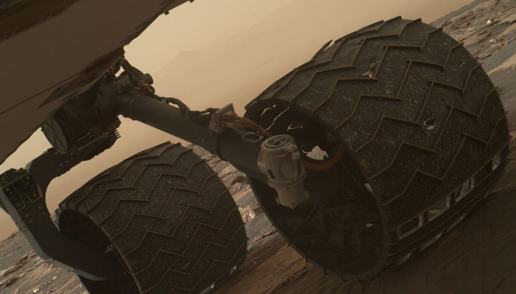
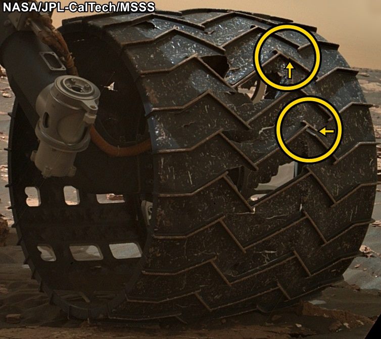
Image taken by the Mars Hand Lens Imager (MAHLI) of Curiosity's wheels on March 19, 2017. Credit: NASA
Since it landed on August 6th, 2012, the Curiosityrover has spent a total of 1644 Sols (or 1689 Earth days) on Mars. And as of March 2017, it has traveled almost 16 km (~10 mi) across the planet and climbed almost a fifth of a kilometer (0.124 mi) uphill. Spending that kind of time on another planet, and traveling that kind of distance, can certainly lead to its share of wear of tear on a vehicle.
That was the conclusion when the Curiosity science team conducted a routine check of the rover’s wheels on Sunday, March 19th, 2017. After examining images taken by the Mars Hand Lens Imager (MAHLI), they noticed two small breaks in the raised treads on the rover’s left middle wheel. These breaks appeared to have happened since late January, when the last routine check of the wheels took place.
To get around, the Curiosity rover relies on six solid aluminum wheels that are 40 cm (16 in) wide. The skin of the wheels is thinner than a US dime, but each contains 19 zigzag-shaped treads that are about 0.75 cm (three-quarters of an inch) thick. These “grousers”, as they are called, bear most of the rover’s weight and provide most of the wheel’s traction.
Close-up image of the broken grousers on Curiosity’s left-middle wheel. Credit: NASA/JPL-Caltech/MSSS
Ever since the rover was forced to cross a stretch of terrain that was studded with sharp rocks in 2013, the Curiosity team has made regular checks on the rover’s wheels using the MAHLI camera. At the time, the rover was moving from the Bradbury Landing site (where it landed in 2012) to the base of Mount Sharp, and traversing this terrain caused holes and dents in the wheels to grow significantly.
However, members of Curiosity’s science team emphasized that this is nothing to be worried about, as it will not affect the rover’s performance or lifespan. As Jim Erickson, the Curiosity Project Manager at NASA’s Jet Propulsion Laboratory, said in a recent NASA press statement:
“All six wheels have more than enough working lifespan remaining to get the vehicle to all destinations planned for the mission. While not unexpected, this damage is the first sign that the left middle wheel is nearing a wheel-wear milestone.”
In addition to regular monitoring, a wheel-longevity testing program was started on Earth in 2013 using identical aluminum wheels. These tests showed that once a wheel got to the point where three of its grousers were broken, it had passed about 60% of its lifespan. However, Curiosity has already driven more than 60% of the total distance needed for it to make it to all of its scientific destinations.
Graphic depicting aspects of the driving distance, elevation, geological units and time intervals of NASA’s Curiosity Mars rover mission, as of late 2016. Credit: NASA/JPL-Caltech
“This is an expected part of the life cycle of the wheels and at this point does not change our current science plans or diminish our chances of studying key transitions in mineralogy higher on Mount Sharp.”
At present, Curiosity is examining sand dunes in the geographical region known as the Murray Buttes formation, which is located on the slope of Mount Sharp. Once finished, it will proceed up higher to a feature known as “Vera Rubin Ridge”, inspecting a layer that is rich in the mineral hematite. From there, it will proceeded to even higher elevations to inspect layers that contain clays and sulfates.
Getting to the farthest destination (the sulfate unit) will require another 6 km (3.7 mi) of uphill driving. However, this is a short distance compared to the kind of driving the rover has already performed. Moreover, the science team has spent the past four years implementing various methods designed to avoid embedded rocks and other potentially hazardous terrain features.
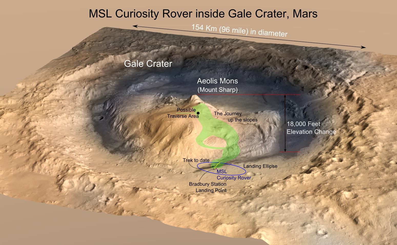
MRO image of Gale Crater illustrating the landing location and trek of the Rover Curiosity. Credits: NASA/JPL, illustration, T.Reyes
It is expected that this drive up Mount Sharp will yield some impressive scientific finds. During its first year on Mars, Curiosity succeeded in gathering evidence in the Gale Crater that showed how Mars once had conditions favorable to life. This included ample evidence of liquid water, all the chemical elements needed for life, and even a chemical source of energy.
By scaling Mount Sharp and examining the layers that were deposited over the course of billions of years, Curiosity is able to examine a living geological record of how the planet has evolved since then. Luckily, the rover’s wheels seem to have more than enough life to make these and (most likely) other scientific finds.
An artist's illustration of SpaceX's Dragon capsule entering the Martian atmosphere. Image: SpaceX
As part of their effort to kick-start the eventual colonization of Mars, SpaceX is sending an unmanned Dragon spacecraft to Mars. Initially, that mission was set for 2018, but is now re-scheduled for 2020. Now, SpaceX says they’re working with NASA to select a suitable landing site for their first Dragon mission to Mars.
At a presentation in Texas on March 18th, Paul Wooster of SpaceX said that they have been working with scientists at NASA’s Jet Propulsion Laboratory (JPL) to identify candidate landing sites on the surface of Mars. In order to aid colonization, the sites need to be:
near the equator, for solar power
near large quantities of ice, for water
at low elevation, for better thermal conditions
But finding a site that meets those conditions is difficult.
According to SpaceNews, the study done with NASA initially recognized 4 regions in Mars’ northern hemisphere, all within 40 degrees of the equator. They are Deuteronilus Mensae, Phlegra Montes, Utopia Planitia, and Arcadia Planitia.
Deuteronilus Mensae
Deuteronilus Mensae (DM) is located between older, cratered highlands and low plains. DM shows evidence of glacial activity in its surface features. In fact, there are still glaciers there, which makes it a desirable source of ice.
Deuteronilus Mensae (DM)has many rough surface features. The Mars Reconnaissance Orbiter has shown that many areas in DM are sub-surface glaciers covered by a thin layer of debris. Image: NASA/JPL/University of Arizona
Phlegra Montes
Phlegra Montes (PM) is a system of mountains on the Martian surface, over 1300 km across. It’s a complex system of basins, hills, and ridges. They are likely tectonic in origin, rather than volcanic, and the region probably contains large quantities of water ice, perhaps 20 meters below the surface.
This tongue shaped flow of material at Phlegra Montes may have been formed by a flow of ice-rich material. Image: NASA/JPL/University of Arizona
Utopia Planitia
Utopia Planitia (UP) is the region where the Viking 2 lander set down in 1976. At 3300 km in diameter, UP is the largest impact basin in the Solar System. In 2016, NASA found a huge deposit of underground ice there. The water is estimated to be the same volume as Lake Superior.
Periglacial features in a small crater in Utopia Planitia. Periglacial refers to the seasonal thawing of snow and ice which refreezes in other shapes. Image: NASA/JPL/University of Arizona
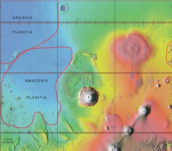
Arcadia Planitia
Arcadia Planitia (AP) is a smooth plain containing fresh lava flows. It also has a large region that was shaped by periglacial processes. This supports the idea that ice is present just beneath the surface, making it a candidate for colonization efforts.
Arcadia Planitia likely has ice just beneath its surface. The knobby pattern is probably caused by the uneven seasonal melting of sub-surface ice. Image: NASA/JPL/University of Arizona
The image below shows the Arcadia Planitia region in relation to some of its surroundings. Colonists at AP might have a great view of Olympus Mons, the largest volcano in the Solar System.
Colonists in Arcadia Planitia (upper left in map) might have a great view of Olympus Mons.
The four areas looked suitable in images from a medium resolution camera (CTX) on the Mars Reconnaissance Orbiter (MRO). But when the High Resolution Imaging Science Experiment (HiRISE) camera on the same orbiter was used to look more closely, the first three locations appeared to be much rockier. According to SpaceNews, Wooster said ““The team at JPL has been finding that, while the areas look very flat and smooth at CTX resolution, with HiRISE images, they’re quite rocky. That’s been unfortunate in terms of the opportunities for those sites.”
The fourth area, Arcadia Planitia, is a more promising site. HiRISE images showed that it is much less rocky and could be a suitable site for the first Dragon mission to Mars.
The Dragon mission to Mars is just the first step for SpaceX. They see themselves as an interplanetary transportation company eventually. SpaceX intends to send a craft to Mars every two years, when the launch window is optimal. SpaceX says they’ll have the ability to deliver one ton of payload to the Martian surface with each Dragon mission.
Their Interplanetary Transport System (ITS) might have the capability to make it to Mars in as little as 80 days, while carrying a payload of up to 450 tons. While still in the very initial stages of design, it may eventually revolutionize our ability to colonize Mars in any meaningful or enduring way. SpaceX envisions a fleet of craft in the ITS which will constantly make the return to trip to Mars.
If that ever happens, we may look at the first Dragon mission to Arcadia Planitia, or another eventual landing site, as the first step.
Layered deposits in Uzboi Vallis on Mars, as seen by the HiRISE camera on the Mars Reconnaissance Orbiter. Credit: NASA/JPL/University of Arizona.
We’ve posted several ‘flyover’ videos of Mars that use data from spacecraft. But this video might be the most spectacular and realistic. Created by filmmaker Jan Fröjdman from Finland, “A Fictive Flight Above Real Mars” uses actual data from the venerable HiRISE camera on board the Mars Reconnaissance Orbiter, and takes you on a 3-D tour over steep cliffs, high buttes, amazing craters, polygons and other remarkable land forms. But Fröjdman also adds a few features reminiscent of the landing videos taken by the Apollo astronauts. Complete with crosshatches and thruster firings, this video puts you on final approach to land on (and then take off from) Mars’ surface.
(Hit ‘fullscreen’ for the best viewing)
To create the video, Fröjdman used 3-D anaglyph images from HiRISE (High Resolution Science Imaging Experiment), which contain information about the topography of Mars surface and then processed the images into panning video clips.
Fröjdman told Universe Today he worked on this video for about three months.
“The most time consuming was to manually pick the more than 33,000 reference points in the anaglyph images,” he said via email. “Now when I count how many steps there were in total in the process, I come to seven and I needed at least 6 different kinds of software.”
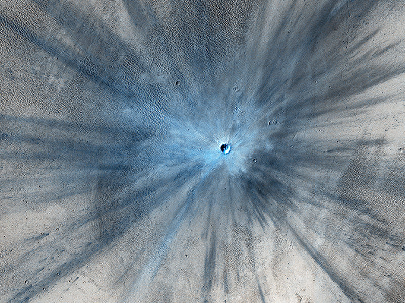
A new impact crater that was formed between July 2010 and May 2012, as seen by the HiRISE camera on the Mars Reconnaissance Orbiter. This image is part of “A Fictive Flight Above Real Mars” by Jan Fröjdman. Credit: NASA/JPL/University of Arizona.
Fröjdman, a landscape photographer and audiovisual expert, said he wanted to create a video that gives you the feeling “that you are flying above Mars looking down watching interesting locations on the planet,” he wrote on Vimeo. “And there are really great places on Mars! I would love to see images taken by a landscape photographer on Mars, especially from the polar regions. But I’m afraid I won’t see that kind of images during my lifetime.”
Between HiRISE and the Curiosity rover images, we have the next best thing to a human on Mars. But maybe one day…
NASA is beginning to integrate the results of its twin study on astronauts Mark and Scott Kelly. Image: NASA
People who plan and conduct space missions never tire of telling us how hard it is to do things in space.
Our next big goal is getting humans to Mars, and establishing a colony there. There are a multitude of technical and engineering hurdles to be overcome, but we think we can do it.
But the other side of the coin is the physiological hurdles to be overcome. Those may prove to be much more challenging to deal with. NASA’s twins study is poised to add an enormous amount of data to our growing body of knowledge on the effects of space travel on human beings.
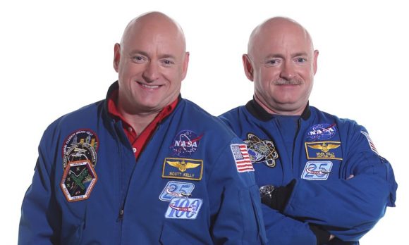
NASA’s astronaut twins, Scott Kelly (l) and Mark Kelly (r). Image: NASA
Astronaut twins Scott and Mark Kelly are the basis of NASA’s study. Scott spent a year in space, returning to Earth on March 1st 2016, after spending 340 days aboard the ISS. Mark, himself a retired astronaut, remained on Earth during Scott’s year in space, providing a baseline for studying the effects on the human body of such a prolonged period of time away from Earth.
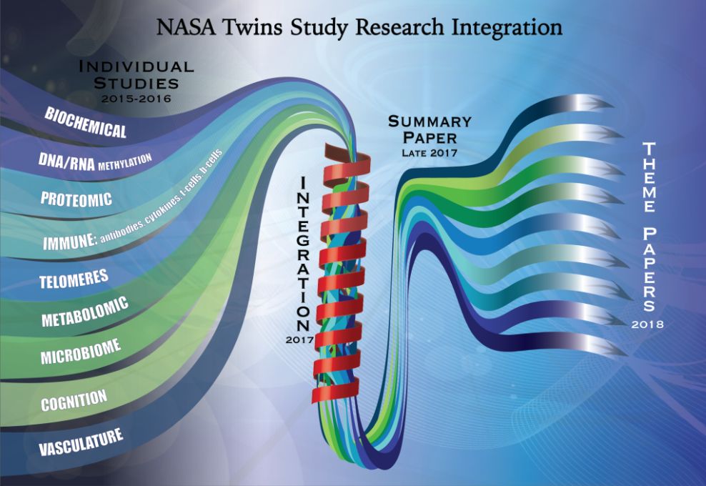
In February of 2016, NASA released preliminary results of the study. Now, the team studying the results of the twins study has started integrating the data. The way they’re doing this sets it apart from other studies.
“No one has ever looked this deeply at a human subject and profiled them in this detail.” – Tejaswini Mishra, Ph.D., Stanford University School of Medicine.
Typically, individual studies are released to appropriate journals more or less one at a time. But in the twins study, the data will be integrated and summarized before individual papers are published on separate themes. The idea is that taken together, their impact on our understanding of prolonged time in space will be much greater.
“The beauty of this study is when integrating rich data sets of physiological, neurobehavioral and molecular information, one can draw correlations and see patterns,” said Tejaswini Mishra, Ph.D., research fellow at Stanford University School of Medicine, who is creating the integrated database, recording results and looking for correlations. “No one has ever looked this deeply at a human subject and profiled them in this detail. Most researchers combine maybe two to three types of data but this study is one of the few that is collecting many different types of data and an unprecedented amount of information.”
“Each investigation within the study complements the other.” – Brinda Rana, Ph.D., U of C, San Diego School of Medicine
Mike Snyder, Ph.D, is the head of a team of people at Stanford that will work to synthesize the data. There are roughly three steps in the overall process:
Individual researchers in areas like cognition, biochemistry, and immunology will analyze and compile their data then share their results with the Stanford team.
The Stanford team will then further integrate those results into larger data sets.
Those larger data sets will then be reviewed and analyzed to confirm and modify the initial findings.
“There are a lot of firsts with this study and that makes it exciting,” said Brinda Rana, Ph.D., associate professor of psychiatry, University of California San Diego School of Medicine. “A comparative study with one twin in space and one on Earth has never been done before. Each investigation within the study complements the other.”
NASA compares the twins study, and the new integrated method of handling all the results, to conducting a symphony. Each study is like an instrument, and instead of each one playing a solo, they will be added into a greater whole. The team at Stanford is like the conductor. If you’ve ever listened to an orchestra, you know how powerful that can be.
“The human systems in the body are all intertwined which is why we should view the data in a holistic way,” said Scott M. Smith, Ph.D., NASA manager for nutritional biochemistry at the Johnson Space Center. He conducts biochemical profiles on astronauts and his research is targeted to specific metabolites, end products of various biological pathways and processes.
“It is a more comprehensive way to conduct research.” – Chris Mason, Ph.D., associate professor, Department of Physiology and Biophysics Weill Cornell Medicine
Chris Mason Ph.D., at Weill Cornell Medicine said, “Both the universe and the human body are complicated systems and we are studying something hard to see. It’s like having a new flashlight that illuminates the previously dark gears of molecular interactions. It is a more comprehensive way to conduct research.”
Scientists involved with the twins study are very clearly excited about this new approach. Having twin astronauts is an extraordinary opportunity, and will advance our understanding of spaceflight on human physiology enormously.
“There is no doubt, the learnings from integrating our data will be priceless,” said Emmanuel Mignot, M.D., Ph.D., director of Center for Sleep Science and Medicine, Stanford University School of Medicine. He studies the immune system and is enthusiastic to study specific immune cell populations because many of the other immune studies focus only on general factors.
A summary of the early results should be out by early 2018, or possible late 2017. Individual papers on more detailed themes will follow shortly.
NASA's Journey to Mars. NASA is developing the capabilities needed to send humans to an asteroid by 2025 and Mars in the 2030s. Credit: NASA/JPL
It’s no secret that NASA has had its share of worries with the Trump administration. In addition to being forced to wait several months to get a sense of the administration’s priorities, the space agency has also had to contend with proposed cuts to its Earth Observation and climate monitoring programs. But one thing which does not appear to be threatened is NASA’s “Journey to Mars“.
In accordance with the National Aeronautics and Space Administration Transition Authorization Act of 2017, the Trump administration has finally committed to funding NASA’s plans for deep space human exploration in the coming decades, and to the tune of $19.5 billion. Central to these plans is the proposed crewed mission to Mars, which is scheduled to take place by 2033.
The Act was introduced to Congress back in February and presented to President Trump for approval on Tuesday, March. 9th. Consistent with the Space Administration Authorization Act of 2010 and the NASA Transition Authorization Act of 2016, this bill approved of $19.5 billion in funding for NASA for fiscal year 2017, much of which was earmarked for the continuation of NASA’s “Journey to Mars”.
NASA has unveiled a new exercise device that will be used by Orion crews to stay healthy on their mission to Mars. Credit: NASA
In addition to maintaining the US government’s commitment “to extend humanity’s reach into deep space, including cis-lunar space, the Moon, the surface and moons of Mars, and beyond”, the Act also expressed the need for a continued commitment to the International Space Station and the utilization of Low Earth Orbit, and other related space ventures.
However, it is Section. 431, Subtitle C – Journey to Mars, that contains all the articles that are of particular interest to space enthusiasts – as these deal with the planned missions to Mars. Article 432, titled “Human Exploration Roadmap”, specifically states that:
“The Administrator shall develop a human exploration roadmap, including a critical decision plan, to expand human presence beyond low-Earth orbit to the surface of Mars and beyond, considering potential interim destinations such as cis-lunar space and the moons of Mars.
The Space Launch System (SLS), the Orion Space Capsule, a deep space habitat, and other capabilities are cited as crucial technologies. Other technologies that are identified are “space suits, solar electric propulsion, deep space habitats, environmental control life support systems, Mars lander and ascent vehicle, entry, descent, landing, ascent, Mars surface systems, and in-situ resource utilization.”
And last, but not least, is the need to pursue robotic and crewed missions that are intended to test these technologies – aka. Exploration Mission-1 (EM-1) and Exploration Mission-2 (EM-2). The former mission (which is scheduled for launch on September 30th, 2018) will be the first launch of the SLS with the Orion Capsule on-board, and will involve an uncrewed Orion being sent on a translunar mission.
Exploration Mission-2 (which is expected to launch in August of 2021) will be consists of a crew of four astronauts conducting another flight around the Moon and returning to Earth. Other crewed explorations are expected to follow during the 2020s, which may or may not include the crewed exploration of an asteroid towed into lunar orbit (as part of the Asteroid Redirect Mission, or ARM).
Here too, the Act was consistent with the NASA Transition Authorization Act of 2016. Based on growing budget assessments and the judgement that the benefits of “the Asteroid Robotic Redirect Mission have not been demonstrated to Congress to be commensurate with the cost”, the Act recommends that NASA select a more “cost-effective” option for testing the Orion capsule.
Aside from testing the components and developing the expertise necessary for a crewed mission to Mars, these mission will also establish an all-important “launch cadence”. In other words, NASA hopes to begin conducting regular launches using the SLS between 2021 and 2023, which will be key to restarting crewed exploration of the Solar System.
Of course, the Act also emphasizes the need for continued research into the potential health risks, which are currently being performed aboard the ISS. These include the dangers of exposure to radiation, the long-term effects of time spent in microgravity environments (i.e. muscle degeneration, loss of bone density, organ degeneration, and loss of eyesight), and efforts to mitigate them.
Of course, critics of the Act cite the adjustments made to spending on Earth sciences and heliophysics. In addition, this funding is only for the coming year, and future commitments will need to be made to ensure that the “Journey to Mars” can happen in the time frame provided. But the Act passed with almost unanimous support, and seems to have confirmed what many observers claimed about the space priorities of a Trump administration.
Proponents of space exploration and a mission to Mars can therefore rest easy, as it seems that both are safe for another year. As for Earth science and research, which are intrinsic to helping us predict the effects of climate change, that’s another battle!
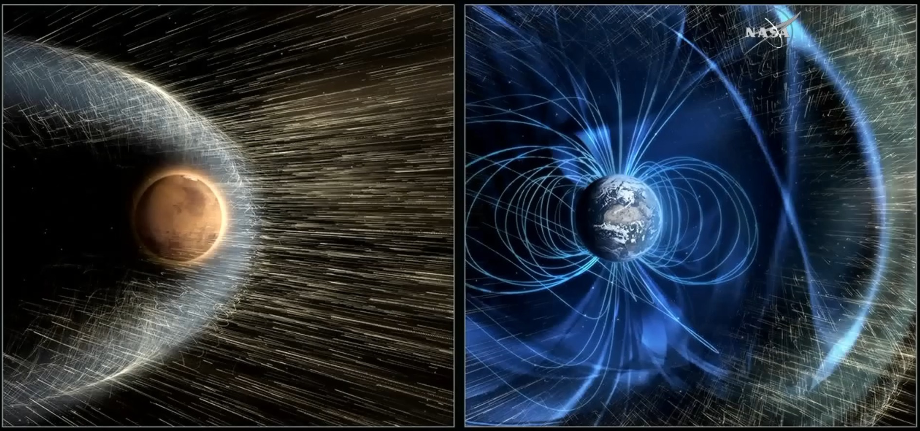
At one time, Mars had a magnetic field similar to Earth, which prevented its atmosphere from being stripped away. Credit: NASA
In the past few decades, astronomers and geophysicists have benefited immensely from the study of planetary magnetic fields. Dedicated to mapping patterns of magnetism on other astronomical bodies, this field has grown thanks to missions ranging from the Voyager probes to the more recent Mars Atmosphere and Volatile EvolutioN (MAVEN) mission.
Looking ahead, it is clear that this field of study will play a vital role in the exploration of the Solar System and beyond. As Jared Espley of NASA’s Goddard Space Flight Center outlined during a presentation at NASA’s Planetary Science Vision 2050 Workshop, these goals include advancing human exploration of the cosmos and the search for extraterrestrial life.
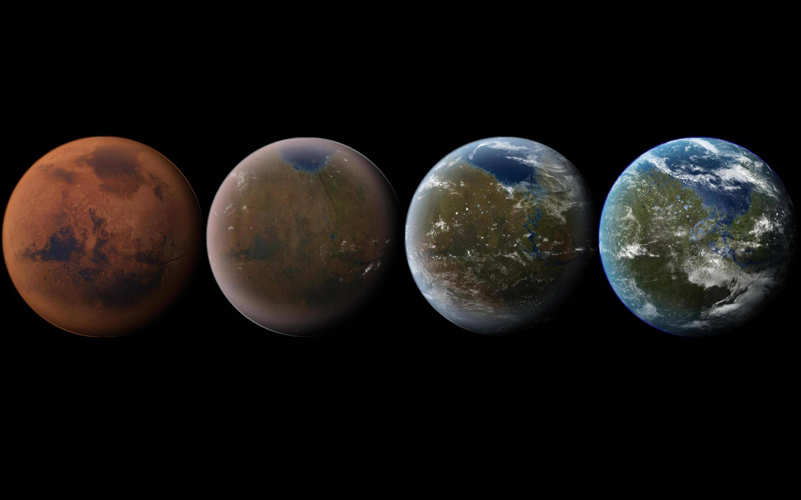
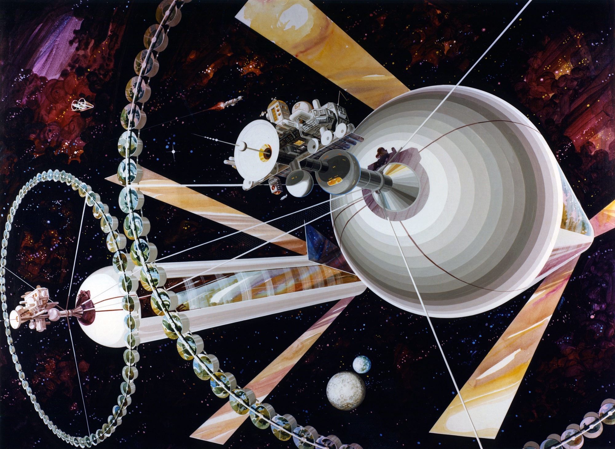
Artist's concept of a terraformed Mars (left) and an O'Neill Cylinder. Credit: Ittiz/Wikimedia Commons (left)/Rick Guidice/NASA Ames Research Center (right)
The idea of terraforming Mars – aka “Earth’s Twin” – is a fascinating idea. Between melting the polar ice caps, slowly creating an atmosphere, and then engineering the environment to have foliage, rivers, and standing bodies of water, there’s enough there to inspire just about anyone! But just how long would such an endeavor take, what would it cost us, and is it really an effective use of our time and energy?
Such were the questions dealt with by two papers presented at NASA’s “Planetary Science Vision 2050 Workshop” last week (Mon. Feb. 27th – Wed. Mar. 1st). The first, titled “The Terraforming Timeline“, presents an abstract plan for turning the Red Planet into something green and habitable. The second, titled “Mars Terraforming – the Wrong Way“, rejects the idea of terraforming altogether and presents an alternative.
The former paper was produced by Aaron Berliner from the University of California, Berkeley, and Chris McKay from the Space Sciences Division at NASA Ames Research Center. In their paper, the two researchers present a timeline for the terraforming of Mars that includes a Warming Phase and an Oxygenation Phase, as well as all the necessary steps that would precede and follow.
Artist’s impression of the terraforming of Mars, from its current state to a livable world. Credit: Daein Ballard
As they state in their paper’s Introduction:
“Terraforming Mars can be divided into two phases. The first phase is warming the planet from the present average surface temperature of -60° C to a value close to Earth’s average temperature to +15° C, and recreating a thick CO² atmosphere. This warming phase is relatively easy and quick, and could take ~100 years. The second phase is producing levels of O² in the atmosphere that would allow humans and other large mammals to breath normally. This oxygenation phase is relatively difficult and would take 100,000 years or more, unless one postulates a technological breakthrough.”
Before these can begin, Berliner and McKay acknowledge that certain “pre-terraforming” steps need to be taken. These include investigating Mars’ environment to determine the levels of water on the surface, the level of carbon dioxide in the atmosphere and in ice form in the polar regions, and the amount of nitrates in Martian soil. As they explain, all of these are key to the practicality of making a biosphere on Mars.
So far, the available evidence points towards all three elements existing in abundance on Mars. While most of Mars water is currently in the form of ice in the polar regions and polar caps, there is enough there to support a water cycle – complete with clouds, rain, rivers and lakes. Meanwhile, some estimates claim that there is enough CO² in ice form in the polar regions to create an atmosphere equal to the sea level pressure on Earth.
Nitrogen is also a fundamental requirement for life and necessary constituent of a breathable atmosphere, and recent data by the Curiosity Rover indicate that nitrates account for ~0.03% by mass of the soil on Mars, which is encouraging for terraforming. On top of that, scientists will need to tackle certain ethical questions related to how terraforming could impact Mars.
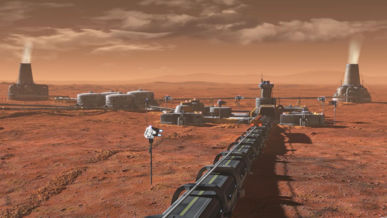
Artist’s concept of a possible Mars terraforming plant. Credit: National Geographic Channel
For instance, if there is currently any life on Mars (or life that could be revived), this would present an undeniable ethical dilemma for human colonists – especially if this life is related to life on Earth. As they explain:
“If Martian life is related to Earth life – possibly due to meteorite exchange – then the situation is familiar, and issues of what other types of Earth life to introduce and when must be addressed. However, if Martian life in unrelated to Earth life and clearly represents a second genesis of life, then significant technical and ethical issues are raised.”
To break Phase One – “The Warming Phase” – down succinctly, the authors address an issue familiar to us today. Essentially, we are altering our own climate here on Earth by introducing CO² and “super greenhouse gases” to the atmosphere, which is increasing Earth’s average temperature at a rate of many degrees centigrade per century. And whereas this has been unintentional on Earth, on Mars it could be re-purposed to deliberately warm the environment.
“The timescale for warming Mars after a focused effort of super greenhouse gas production is short, only 100 years or so,” they claim. “If all the solar incident on Mars were to be captured with 100% efficiency, then Mars would warm to Earth-like temperatures in about 10 years. However, the efficiency of the greenhouse effect is plausibly about 10%, thus the time it would take to warm Mars would be ~100 years.”
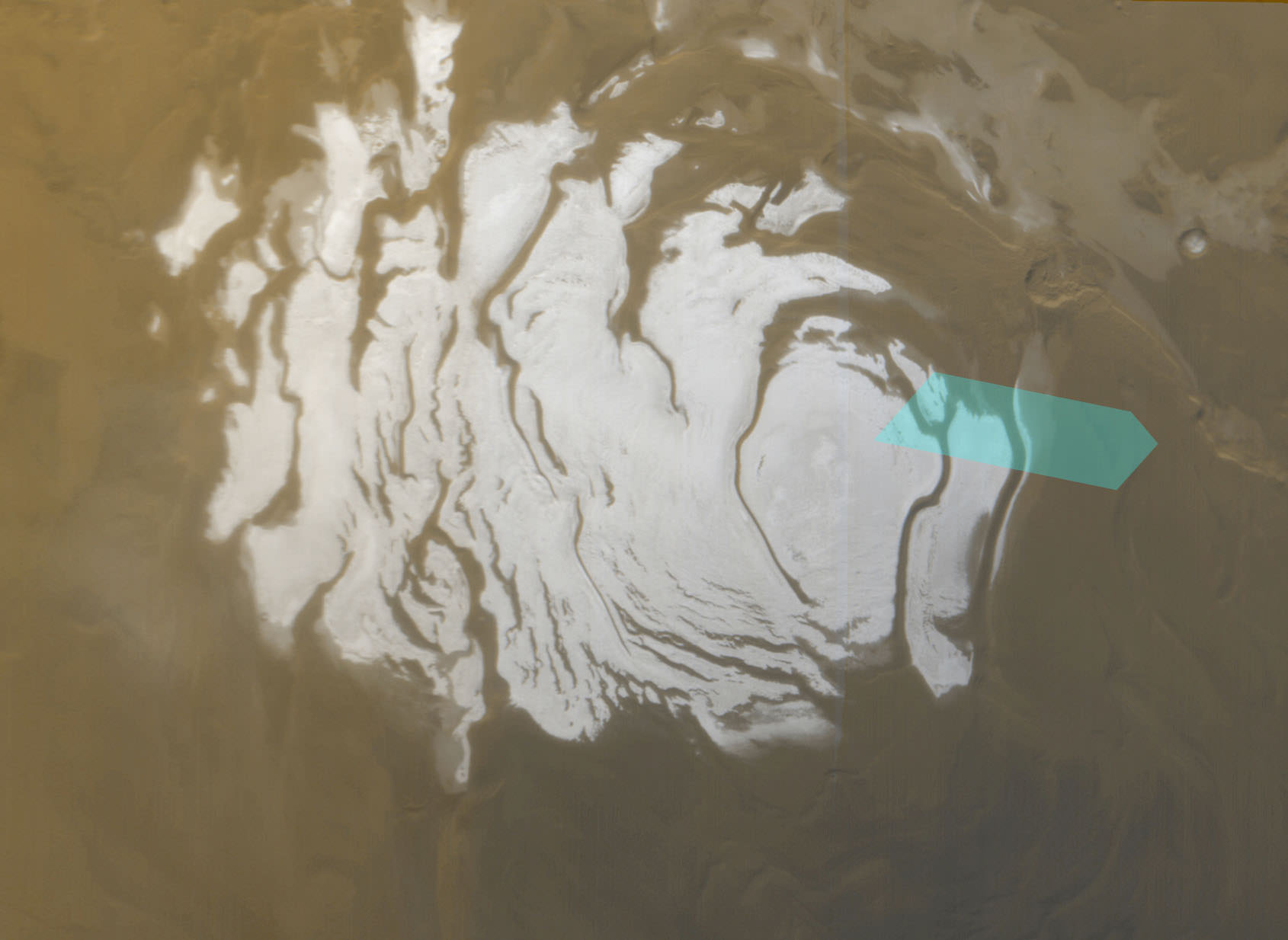
Mars’ south polar ice cap, as seen in April of 2000 by the Mars Odyssey mission. Credit: NASA/JPL/MSSS
Once this thick atmosphere has been created, the next step involves converting it into something breathable for humans – where O² levels would be the equivalent of about 13% of sea level air pressure here on Earth and CO² levels would be less than 1%. This phase, known as the “Oxygenation Phase”, would take considerably longer. Once again, they turn towards a terrestrial example to show how such a process could work.
Here on Earth, they claim, the high levels of oxygen gas (O²) and low levels of CO² are due to photosynthesis. These reactions rely on the sun’s energy to convert water and carbon dioxide into biomass – which is represented by the equation H²O + CO² = CH²O + O². As they illustrate, this process would take between 100,000 and 170,000 years:
“If all the sunlight incident on Mars was harnessed with 100% efficiency to perform this chemical transformation it would take only 17 years to produce high levels of O². However, the likely efficiency of any process that can transform H²O and CO² into biomass and O² is much less than 100%. The only example we have of a process that can globally alter the CO² and O² of an entire plant is global biology. On Earth the efficiency of the global biosphere in using sunlight to produced biomass and O2 is 0.01%. Thus the timescale for producing an O² rich atmosphere on Mars is 10,000 x 17 years, or ~ 170,000 years.”
However, they make allowances for synthetic biology and other biotechnologies, which they claim could increase the efficiency and reduce the timescale to a solid 100,000 years. In addition, if human beings could utilize natural photosynthesis (which has a comparatively high efficiency of 5%) over the entire planet – i.e. planting foliage all over Mars – then the timescale could be reduced to even a few centuries.
Finally, they outline the steps that need to be taken to get the ball rolling. These steps include adapting current and future robotic missions to assess Martian resources, mathematical and computer models that could examine the processes involved, an initiative to create synthetic organisms for Mars, a means to test terraforming techniques in a limited environment, and a planetary agreement that would establish restrictions and protections.
Quoting Kim Stanley Robinson, author of the Red Mars Trilogy, (the seminal work of science fiction about terraforming Mars) they issue a call to action. Addressing how long the process of terraforming Mars will take, they assert that we “might as well start now”.
To this, Valeriy Yakovlev – an astrophysicist and hydrogeologist from Laboratory of Water Quality in Kharkov, Ukraine – offers a dissenting view. In his paper, “Mars Terraforming – the Wrong Way“, he makes the case for the creation of space biospheres in Low Earth Orbit that would rely on artificial gravity (like an O’Neill Cylinder) to allow humans to grow accustomed to life in space.
Looking to one of the biggest challenges of space colonization, Yakovlev points to how life on bodies like the Moon or Mars could be dangerous for human settlers. In addition to being vulnerable to solar and cosmic radiation, colonists would have to deal with substantially lower gravity. In the case of the Moon, this would be roughly 0.165 times that which humans experience here on Earth (aka. 1 g), whereas on Mars it would be roughly 0.376 times.
Interior view of an O’Neill Cylinder. There are alternating strips of livable surface and “windows” to let light in. Credit: Rick Guidice/NASA Ames Research Center
The long-term effects of this are not known, but it is clear it would include muscle degeneration and bone loss. Looking farther, it is entirely unclear what the effects would be for those children who were born in either environment. Addressing the ways in which these could be mitigated (which include medicine and centrifuges), Yakovlev points out how they would most likely be ineffective:
“The hope for the medicine development will not cancel the physical degradation of the muscles, bones and the whole organism. The rehabilitation in centrifuges is less expedient solution compared with the ship-biosphere where it is possible to provide a substantially constant imitation of the normal gravity and the protection complex from any harmful influences of the space environment. If the path of space exploration is to create a colony on Mars and furthermore the subsequent attempts to terraform the planet, it will lead to the unjustified loss of time and money and increase the known risks of human civilization.”
In addition, he points to the challenges of creating the ideal environment for individuals living in space. Beyond simply creating better vehicles and developing the means to procure the necessary resources, there is also the need to create the ideal space environment for families. Essentially, this requires the development of housing that is optimal in terms of size, stability, and comfort.
In light of this, Yakolev presents what he considers to be the most likely prospects for humanity’s exit to space between now and 2030. This will include the creation of the first space biospheres with artificial gravity, which will lead to key developments in terms of materials technology, life support-systems, and the robotic systems and infrastructure needed to install and service habitats in Low Earth Orbit (LEO).
Artist’s depiction of a pair of O’Neill cylinders. Credit: Rick Guidice/NASA Ames Research Center
These habitats could be serviced thanks to the creation of robotic spacecraft that could harvest resources from nearby bodies – such as the Moon and Near-Earth Objects (NEOs). This concept would not only remove the need for planetary protections – i.e. worries about contaminating Mars’ biosphere (assuming the presence of bacterial life), it would also allow human beings to become accustomed to space more gradually.
As Yakovlev told Universe Today via email, the advantages to space habitats can be broken down into four points:
“1. This is a universal way of mastering the infinite spaces of the Cosmos, both in the Solar System and outside it. We do not need surfaces for installing houses, but resources that robots will deliver from planets and satellites. 2. The possibility of creating a habitat as close as possible to the earth’s cradle allows one to escape from the inevitable physical degradation under a different gravity. It is easier to create a protective magnetic field.
“3. The transfer between worlds and sources of resources will not be a dangerous expedition, but a normal life. Is it good for sailors without their families? 4. The probability of death or degradation of mankind as a result of the global catastrophe is significantly reduced, as the colonization of the planets includes reconnaissance, delivery of goods, shuttle transport of people – and this is much longer than the construction of the biosphere in the Moon’s orbit. Dr. Stephen William Hawking is right, a person does not have much time.”
And with space habitats in place, some very crucial research could begin, including medical and biologic research which would involve the first children born in space. It would also facilitate the development of reliable space shuttles and resource extraction technologies, which will come in handy for the settlement of other bodies – like the Moon, Mars, and even exoplanets.
Ultimately, Yakolev thinks that space biospheres could also be accomplished within a reasonable timeframe – i.e. between 2030 and 2050 – which is simply not possible with terraforming. Citing the growing presence and power of the commercial space sector, Yakolev also believed a lot of the infrastructure that is necessary is already in place (or under development).
“After we overcome the inertia of thinking +20 years, the experimental biosphere (like the settlement in Antarctica with watches), in 50 years the first generation of children born in the Cosmos will grow and the Earth will decrease, because it will enter the legends as a whole… As a result, terraforming will be canceled. And the subsequent conference will open the way for real exploration of the Cosmos. I’m proud to be on the same planet as Elon Reeve Musk. His missiles will be useful to lift designs for the first biosphere from the lunar factories. This is a close and direct way to conquer the Cosmos.”
With NASA scientists and entrepreneurs like Elon Musk and Bas Landorp looking to colonize Mars in the near future, and other commercial aerospace companies developing LEO, the size and shape of humanity’s future in space is difficult to predict. Perhaps we will jointly decide on a path that takes us to the Moon, Mars, and beyond. Perhaps we will see our best efforts directed into near-Earth space.
Or perhaps we will see ourselves going off in multiple directions at once. Whereas some groups will advocate creating space habitats in LEO (and later, elsewhere in the Solar System) that rely on artificial gravity and robotic spaceships mining asteroids for materials, others will focus on establishing outposts on planetary bodies, with the goal of turning them into “new Earths”.
Between them, we can expect that humans will begin developing a degree of “space expertise” in this century, which will certainly come in handy when we start pushing the boundaries of exploration and colonization even further!


