Gerard Kuiper, founder of the Lunar and Planetary Laboratory. Credit: lpl.arizona.edu
In the outer reaches of the Solar System, beyond the orbit of Neptune, lies a region permeated by celestial objects and minor planets. This region is known as the “Kuiper Belt“, and is named in honor of the 20th century astronomer who speculated about the existence of such a disc decades before it was observed. This disc, he reasoned, was the source of the Solar Systems many comets, and the reason there were no large planets beyond Neptune.
Gerard Kuiper is also regarded by many as being the “father of planetary science”. During the 1960s and 70s, he played a crucial role in the development of infrared airborne astronomy, a technology which led to many pivotal discoveries that would have been impossible using ground-based observatories. At the same time, he helped catalog asteroids, surveyed the Moon, Mars and the outer Solar System, and discovered new moons.
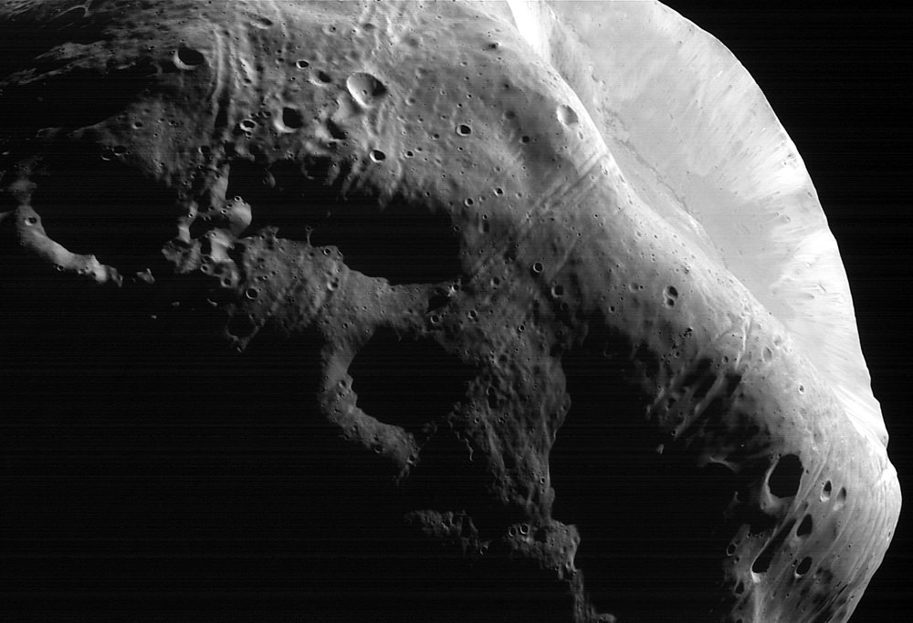
New modeling indicates that the grooves on Mars’ moon Phobos could be produced by tidal forces – the mutual gravitational pull of the planet and the moon. Initially, scientists had thought the grooves were created by the massive impact that made Stickney crater (lower right). Credit: NASA/JPL-Caltech/University of Arizona
We’ve said it before: Mars’ moon Phobos is doomed. But a new study indicates it might be worse than we thought.
One of the most striking features we see on images of Phobos is the parallel sets of grooves on the moon’s surface. They were originally thought to be fractures caused by an impact long ago. But scientists now say the grooves are early signs of the structural failure that will ultimately destroy this moon.
“We think that Phobos has already started to fail, and the first sign of this failure is the production of these grooves,” said Terry Hurford, from NASA’s Goddard Space Flight Center.
Why is Phobos falling apart?
Two words: tidal forces.
Phobos orbits closer to its planet than any moon in the Solar System. As it orbits just 6,000 km (3,700 miles) above Mars, and the planet’s gravity is pulling Phobos in closer and closer; it is also tearing Phobos apart. Scientists estimate the ultimate destruction of this tiny moon (22 kilometers/13.5-miles in diameter) might take place in about 30 to 50 million years.
It only take about 7.5 hours for Phobos to complete an orbit around the planet, while Mars takes almost 25 hours to complete one rotation on its axis. So Phobos travels three times around the planet for every Martian day. And as Fraser explains in this video, this is a problem.
Mars’ gravity is pulling in Phobos closer by about 2 meters (6.6 feet) every hundred years. The orbit will get lower and lower until it reaches a level known as the Roche Limit. This is the point where the tidal forces between the two sides of the moon are so different that it gets torn apart.
Hurford and his colleagues, who presented their latest findings at the annual Meeting of the Division of Planetary Sciences of the American Astronomical Society this week, also delivered other bad news about the interior of Phobos – which could ultimately speed up the demise of the moon. Phobos’ insides are likely to be just a big pile of rubble — barely holding together — surrounded by a layer of powdery regolith about 100 meters (330 feet) thick.
“The funny thing about the result is that it shows Phobos has a kind of mildly cohesive outer fabric,” said Erik Asphaug of the School of Earth and Space Exploration at Arizona State University in Tempe and a co-investigator on the study. “This makes sense when you think about powdery materials in microgravity, but it’s quite non-intuitive.”
Phobos’ Stickney Crater. Credit: NASA.
Phobos’ grooves have long been an issue up for debate. As mentioned previously, one idea is that the grooves were associated with the impact that formed Stickney Crater, a big 10 km-wide crater that dominates one side of Phobos. However, scientists eventually determined that the grooves don’t radiate outward from the crater itself but from a focal point nearby. Another idea is they came from Phobos moving through streams of debris thrown up from impacts 6,000 km away on the surface of Mars, with each ‘family’ of grooves corresponding to a different impact event.
But new modeling by Hurford and his team supports the idea that the grooves are more like “stretch marks” that occur when Phobos gets deformed by tidal forces.
The team said that stress fractures predicted by their model coincide with the grooves seen in images of Phobos. This explanation also fits with the observation that some grooves are younger than others, which would be the case if the process that creates them is ongoing.
Huford also said the same fate may await Neptune’s moon Triton, which is also slowly falling inward and has a similarly fractured surface. The work also has implications for extrasolar planets, according to researchers.
“We can’t image those distant planets to see what’s going on, but this work can help us understand those systems, because any kind of planet falling into its host star could get torn apart in the same way,” said Hurford.
Here’s a video showing Mars Express images of Phobos over the last 10 years. The images show the grooves running across the small moon:
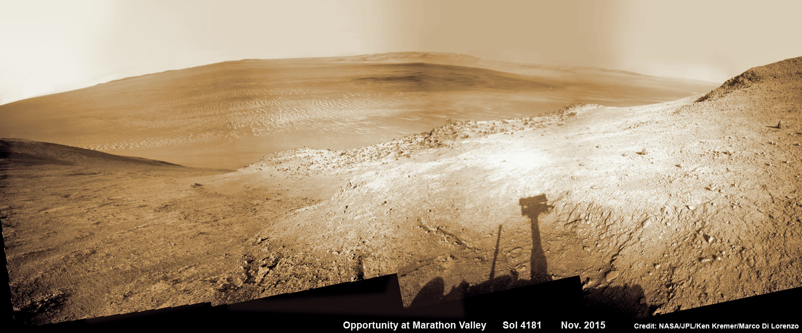
NASA’s Opportunity rover peers outwards across to the vast expense of Endeavour Crater from current location descending along steep walled Marathon Valley in early November 2015. Marathon Valley holds significant deposits of water altered clay minerals holding clues to the planets watery past. Shadow of Pancam Mast assembly and robots deck visible at right. This navcam camera photo mosaic was assembled from images taken on Sol 4181 (Oct. 29, 2015) and colorized. Credit: NASA/JPL/Cornell/Ken Kremer/kenkremer.com/Marco Di Lorenzo
NASA’s Opportunity rover peers outwards across to the vast expense of Endeavour Crater from current location descending along steep walled Marathon Valley in early November 2015. Marathon Valley holds significant deposits of water altered clay minerals holding clues to the planets watery past. Shadow of Pancam Mast assembly and robots deck visible at right. This navcam camera photo mosaic was assembled from images taken on Sol 4181 (Oct. 29, 2015) and colorized. Credit: NASA/JPL/Cornell/Ken Kremer/kenkremer.com/Marco Di Lorenzo
Just shy of an unfathomable 4200 Sols traversing ravishing alien terrain on the Red Planet, the longest living ‘Martian’ – NASA’s robot ‘Opportunity’ – is driving between “lily pads” down steep walled Marathon Valley in search of life giving sun that enables spectacular science yielding clues to Marswatery past. All this as she strives to survive utterly harsh climate extremes, because ‘winter is coming’ for her seventh time on the fourth rock from the sun!
“Opportunity is driving east and southeast down Marathon Valley, bisecting the region in which we detect smectites [clay minerals] using CRISM [spectrometer] data,” Opportunity Deputy Principal Investigator Ray Arvidson, of Washington University in St. Louis, told Universe Today.
Europa is probably the best place in the Solar System to go searching for life. But before they’re launched, any spacecraft we send will need to be squeaky clean so don’t contaminate the place with our filthy Earth bacteria. Continue reading “Will We Contaminate Europa?”
Special Guest: Mike Massimino, Former Astronaut; Senior Advisor for Space Programs at the Intrepid Sea, Air & Space Museum; Full-time instructor at Columbia University; Human-machine systems, space robotics, and human space flight.
Artist’s rendering of a solar storm hitting Mars and stripping ions from the planet's upper atmosphere. Credits: NASA/GSFC
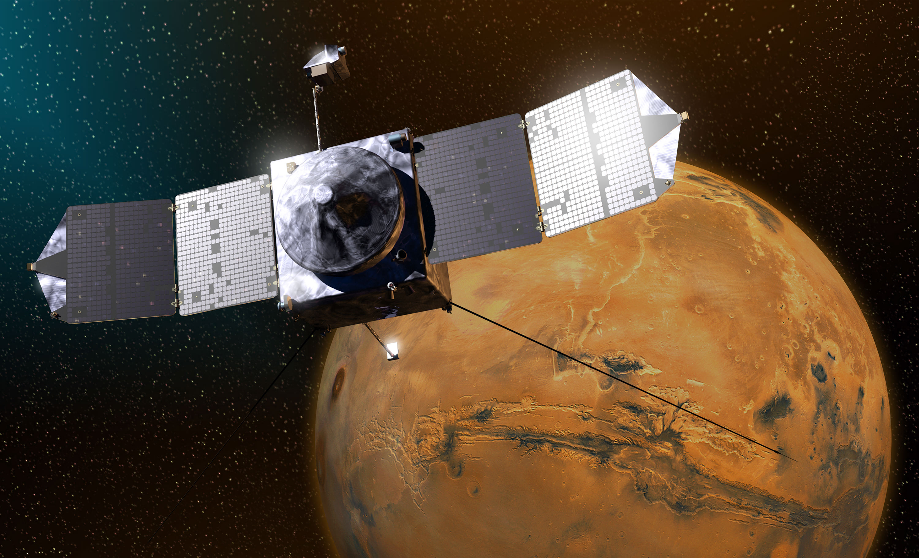
NASA’s Mars Atmosphere and Volatile Evolution (MAVEN) orbiter mission has determined that ancient Mars suffered drastic climate change and lost its thick atmosphere and surface bodies of potentially life giving liquid water because it lost tremendous quantities of gas to space via stripping by the solar wind, based on new findings that were announced today, Nov. 5, at a NASA media briefing and in a series of scientific publications.
The process of Mars dramatic transformation from a more Earth-like world to its barren state today started about 4.2 Billion years ago as the shielding effect of the global magnetic field was lost as the planets internal dynamo cooled, Bruce Jakosky, MAVEN principal investigator at the Laboratory for Atmospheric and Space Physics (LASP) at the University of Colorado, Boulder, told Universe Today.
The radical transformation of ancient Mars from a warm world with significant bodies of standing water that could have supported life, to its current state as a cold, arid and desert-like world that’s rather inhospitable to life was caused by the loss of most the planet’s atmosphere as powerful streams of solar wind particles crashed into it and stripped it away due to the loss of the protective magnetic field as the planets core cooled.
“We think that the early magnetic field that Mars had would have protected the planet from direct impact by the solar wind and would have kept it from stripping gas off,” Jakosky told me.
“So it would have been the turn off of the magnetic field, that would have allowed the turn on of stripping of the atmosphere by the solar wind.”
“The evidence suggests that the magnetic field disappeared about 4.2 Billion years ago.”
The period of abundant surface water actively carving the Martian geology lasted until about 3.7 Billion years ago. The loss of the atmosphere by stripping of the solar wind took place from about 4.2 to 3.7 Billion years ago.
Billions of years ago, Mars was a very different world. Liquid water flowed in long rivers that emptied into lakes and shallow seas. A thick atmosphere blanketed the planet and kept it warm. Credit: NASA
With the release of today’s results, the MAVEN science team has accomplished the primary goal of the mission, which was to determine how and why Mars lost its early, thick atmosphere and water over the past four billion years. The atmosphere is composed mostly of carbon dioxide.
Since water is a prerequisite for life as we know it, determining its fate and longevity on Mars is crucial for determining the habitability of the Red Planet and its potential for supporting martian microbes, past of present if they ever existed.
“The NASA Mars exploration program has been focused on finding water,” said Michael Meyer, lead scientist for the Mars Exploration Program at NASA Headquarters.
“Water is the prime ingredient needed for life. It is a major factor in the climate and for shaping geology. And it is a critical resource for future human exploration.”
This NASA video shows a visualization of the solar wind striking Mars:
Video caption: Created using data from NASA’s Mars Atmosphere and Volatile Evolution (MAVEN) mission, this visualization shows how the solar wind strips ions from the Mars’ upper atmosphere into space. Credits: NASA-GSFC/CU Boulder LASP/University of Iowa
MAVEN arrived in orbit at Mars just over one year ago on Sept. 21, 2014.
The $671 Million MAVEN spacecraft’s goal is to study Mars tenuous upper atmosphere in detail for the very first time by any spacecraft and to explore the mechanisms of how the planet lost its atmosphere and life giving water over billions of years as well as determine the rate of atmospheric loss.
The new MAVEN data have enabled researchers to measure the rate of Mars atmospheric loss of gas to space via the action of solar wind stripping as well as the erosional effect of solar storms.
Based on measurements from MAVEN’s suite of nine state-of-the-art scientific instruments, the solar wind is stripping away gas at a rate of about 100 grams (equivalent to roughly 1/4 pound) every second today, in the form of carbon dioxide and oxygen, said David Brain, MAVEN co-investigator at LASP.
“Most of the stripping [of the Martian atmosphere] by the solar wind at Mars was thought to have taken place very early in the history of the solar system when the sun was much more active and when the solar wind was more intense. So today the rate of loss at Mars is low,” Jakosky said at the briefing.
“Today’s Mars is a cold dry desert-like environment. The atmosphere is thin and it’s not capable of sustaining liquid water at the surface today, it would freeze or evaporate very quickly. However when we look at ancient Mars we see a different type of surface, one that had valleys that looked like they were carved by water and lakes that were standing for long periods of time. We see an environment that was much more able to support liquid water.”
The MAVEN results were published today in nearly four dozen scientific papers in the Nov. 5 issues of the journals Science and Geophysical Research Letters.
I asked Jakosky; How much gas would have been lost from ancient Mars and what is the rough estimate for the ancient rate of loss to arrive at Mars thin atmosphere today?
“For the amount of gas that we think you would have to have been removed – let me start with the current Mars atmosphere which has a thickness of 6 millibars, that’s just under 1% as thick as the Earth’s atmosphere,” Jakosky replied.
“So we think you would have to remove an amount of gas that is about equivalent to what’s in Earth’s atmosphere today.”
“So the rate would have to have been a factor of about 100 to 1000 times higher, than today’s loss of 100 grams per second in order to have removed the gas early in that time period, which is consistent with what the models have predicted that the loss rate would have been back then in early history.”
NASA’s Mars Atmosphere and Volatile EvolutioN (MAVEN) spacecraft celebrated one Earth year in orbit around Mars on Sept. 21, 2015. MAVEN was launched to Mars on Nov. 18, 2013 from Cape Canaveral Air Force Station in Florida and successfully entered Mars’ orbit on Sept. 21, 2014. Credit: NASA
What is the solar wind and how does it strip away the atmosphere?
“The solar wind is a stream of particles, mainly protons and electrons, flowing from the sun’s atmosphere at a speed of about one million miles per hour. The magnetic field carried by the solar wind as it flows past Mars can generate an electric field, much as a turbine on Earth can be used to generate electricity. This electric field accelerates electrically charged gas atoms, called ions, in Mars’ upper atmosphere and shoots them into space,” according to a NASA description.
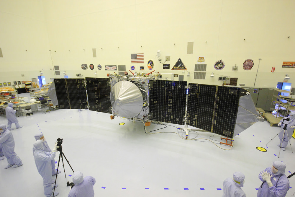
MAVEN is NASA’s next Mars orbiter and is due to blastoff on Nov. 18 from Cape Canaveral, Florida. It will study the evolution of the Red Planet’s atmosphere and climate. Universe Today visited MAVEN inside the clean room at the Kennedy Space Center. With solar panels unfurled, this is exactly how MAVEN looks when flying through space and circling Mars. Credit: Ken Kremer/kenkremer.com
MAVEN is just now completing its primary mission and starts the extended mission phase on Nov. 16.
The 5,400 pound MAVEN probe carries nine sensors in three instrument suites to study why and exactly when did Mars undergo the radical climatic transformation.
MAVEN’s observations will be tied in with NASA’s ongoing Curiosity and Opportunity surface roving missions as well as MRO and Mars Odyssey to provide the most complete picture of the fourth rock from the sun that humanity has ever had.
MAVEN thundered to space on Nov. 18, 2013 following a flawless blastoff from Cape Canaveral Air Force Station’s Space Launch Complex 41 atop a powerful United Launch Alliance Atlas V rocket.
Stay tuned here for Ken’s continuing Earth and planetary science and human spaceflight news.
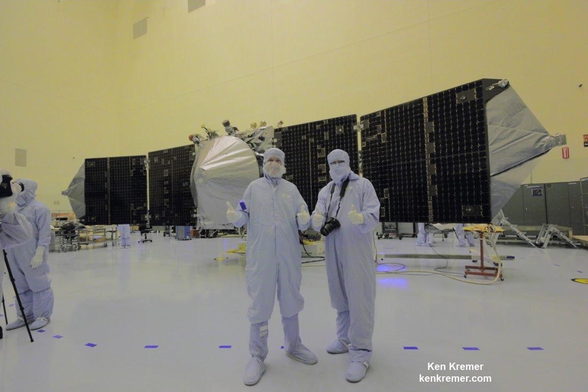
NASA’s MAVEN Mars orbiter, chief scientist Prof. Bruce Jakosky of CU-Boulder and Ken Kremer of Universe Today inside the clean room at the Kennedy Space Center on Sept. 27, 2013. MAVEN launched to Mars on Nov. 18, 2013 from Florida. Credit: Ken Kremer/kenkremer.com
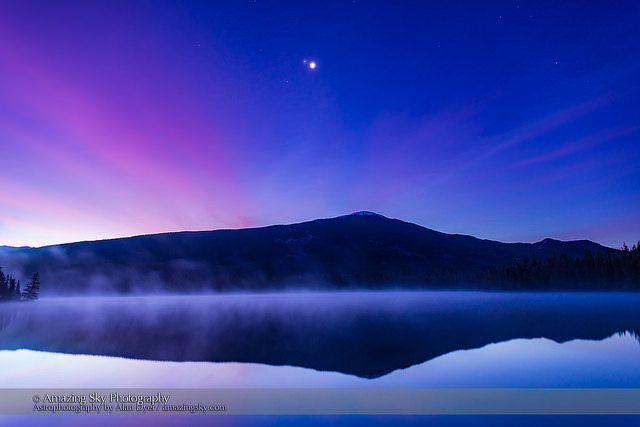
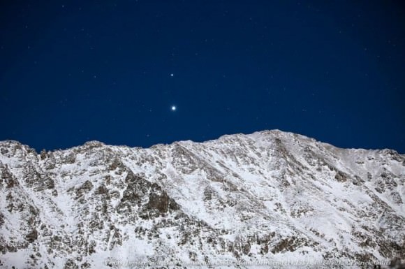
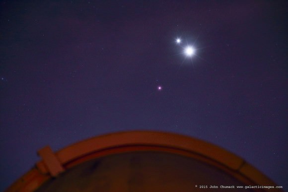
The conjunction of Venus (brightest), Jupiter (above Venus) and Mars (dimmer below Venus & Jupiter) looking east in the morning twilight on October 25, 2015, as seen from the west shore of Lake Annette, in Jasper National Park, Alberta. The mountain is the Watchtower. Morning mist covers the lake waters. Haze in the sky adds the natural glows around the planets — no filters were used. Credit and copyright: Alan Dyer.
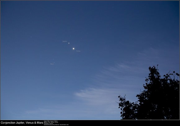
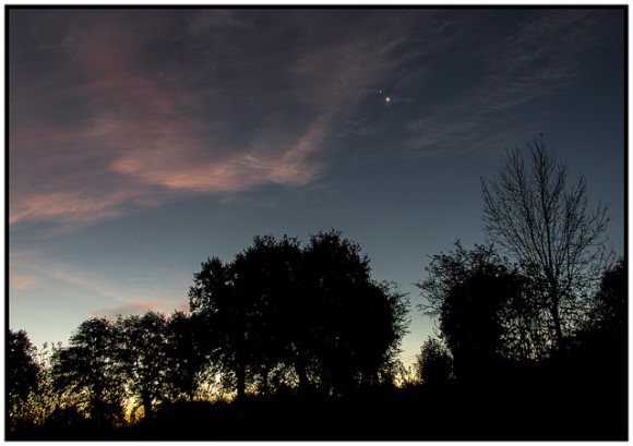
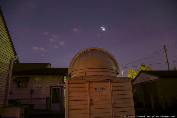
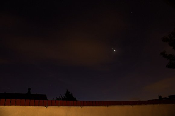
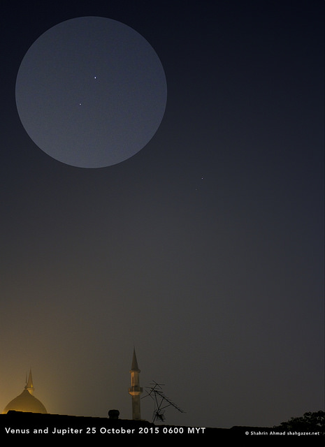
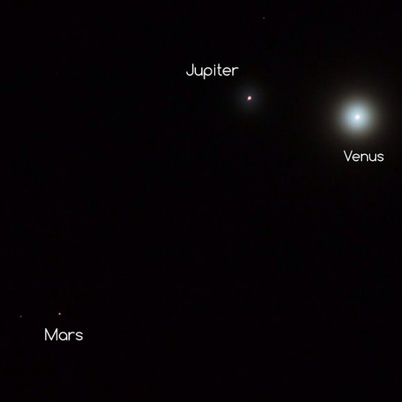
Have you seen the views in the morning skies this week, with three planets huddling together at dawn? Just one degree separated planets Jupiter and Venus, with Mars sneaking in nearby. Astrophotographers were out in full force to capture the scene!
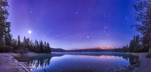
Above, the very talented photographer Alan Dyer from Canada captured a stunning image of the planetary trio over Lake Annette, in Jasper National Park, Alberta, Canada. He took several gorgeous shots, and so we’ve added one more of his below, plus dozens of other wonderful shots from our astrophotographer friends around the world. Each of these images are from Universe Today’s Flickr pool, so you can click on each picture to get a larger view on Flickr.
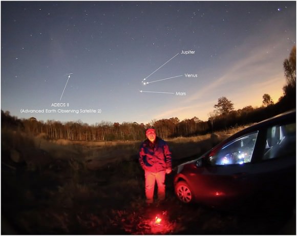
Enjoy these great views, as there won’t be a more compact arrangement of three planets again until January 10, 2021.
A panorama of roughly 120° showing a star- and planet-filled sky in the dawn twilight over Lake Annette in Jasper National Park, Alberta, on the morning of October 25, 2015. At left, to the east, are the two bright planets, Venus (brightest) and Jupiter in a close conjunction 1° apart (and here almost merging into one glow), plus reddish Mars below them, all in Leo, with the bright star Regulus above them. Right of centre, to the south, is Orion and Canis Major, with the bright star Sirius low in the south. At upper right are the stars of Taurus, including Aldebaran and the Hyades star cluster. Venus was near greatest elongation on this morning. Credit and copyright: Alan Dyer.Taken from Coral Towers Observatory in Queensland, Australia on October 28, 2014. Venus is to the right of and slightly below Jupiter and Mars is to the right of and below Venus. The pre-dawn landscape is illuminated by moonlight. Credit and copyright: Joseph Brimacombe.Jupiter, Venus, and Mars rise behind the 14,155 foot peak of Mount Democrat in Colorado. Credit and copyright: Patrick Cullis.Spooky Selfie, Three Planets and a Dead Satellite. The planetary conjunction of Jupiter, Venus and Mars on October 26, 2015, along with the ADEOS II satellite, which died in orbit in 2003 after the solar panels failed. Credit and copyright: Tom Wildoner.Planetary conjunction of Jupiter, Venus and Mars as seen from Search Results Map of Le Puy Saint-Bonnet, 49300 Cholet, France Le Puy Saint-Bonnet, 49300 Cholet, France Le Puy-Saint-Bonnet in France on October 26, 2015. Credit and copyright: David de Cueves.Venus, Jupiter and Mars grace the morning skies in France on October 26, 2015. Credit and copyright: Frank Tyrlik.
Here’s a timelapse from Damien Weatherley of his planet imaging session from the morning of October 25, 2015:
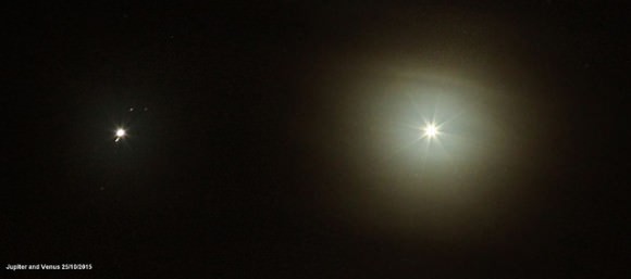
Venus, Jupiter & Mars create a close triangle in the eastern sky at dawn! John Chumack captured this image above his backyard Observatory in Dayton, Ohio on 10-26-2015. Credit and copyright: John Chumack.A zoomed out view of the planetary trio from John Chumack’s observatory in Dayton, Ohio on October 25, 2015. Credit and copyright: John Chumack.Conjunction of Venus, Jupiter & Mars on the morning of Monday Oct. 26, 2015. Credit and copyright: Holly Roberts.Jupiter and Venus conjunction on October 25, 2015. They were approximately with a degree and a half of each other. Jupiter’s moons are visible. Credit and copyright: Chris Lyons. Venus and the almost invisible Jupiter struggled to shine through the haze on the morning of October 25, 2015, as seen in Malaysia. Credit and copyright:Shahrin Ahmad.Venus, Jupiter and Mars in the hazy, cloudy morning skies over the UK on October 25, 2015. Credit and copyright: Sarah and Simon Fisher.
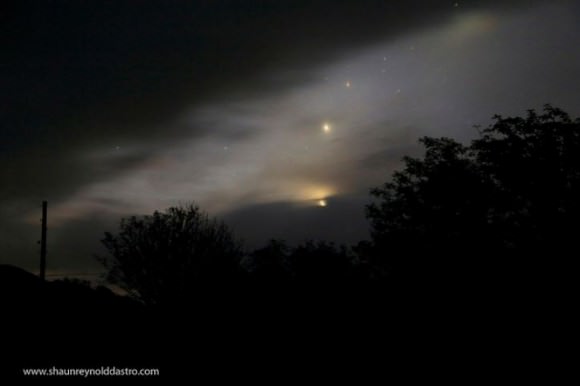
And here’s just a reminder that this planetary conjunction has been setting up for a while. Here’s a shot from October 10 of the planets as they started moving closer together:
A spooky planetary conjunction of Venus, Jupiter and Mars on October 10, 2015 on the Isle of Mull, Scotland. Credit and copyright: Shaun Reynold.
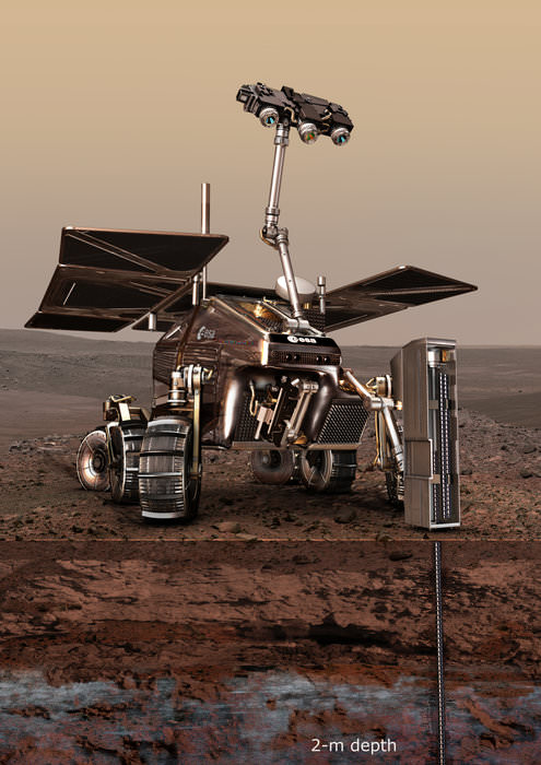
Possible future Mars landing site in Oxia Planum. Credit: NASA/JPL/University of Arizona.
The joint ESA and Russian ExoMars rover’s top priority is to search the Martian surface for signs of life, past or present, and scientists think they know just the spot where – if life ever existed or exists on Mars – it might be found. Today the ExoMars team announced that the equatorial region named Oxia Planum has been recommended as the primary candidate for the landing site.
“Our preliminary analysis shows that Oxia Planum appears to satisfy the strict engineering constraints while also offering some very interesting opportunities to study, in situ, places where biosignatures might best be preserved,” said Jorge Vago, ESA’s project scientist.
An artist’s conception of the ExoMars 2018 rover on the Red Planet. Image credit: ESA
The rover is currently scheduled to launch in 2018 and land on Mars in 2019, but the timetable is still under review, depending on any issues with construction of the rover. While the final landing site won’t be selected by both ESA and Roscosmos until six months before launch, this recommendation will weigh heavily in the decision.
Some of the priority requirements for the landing site is that is must show abundant morphological and mineralogical evidence for long-duration, or frequently reoccurring water activity, and that there should be numerous sedimentary rock outcrops.
From orbital study by previous missions, Oxia Planum is known to contain clays, and there appears to be remnants of a possible fan or delta, as seen in the image above from the HiRISE camera on the Mars Reconnaissance Orbiter. This would be one of the potential science targets.
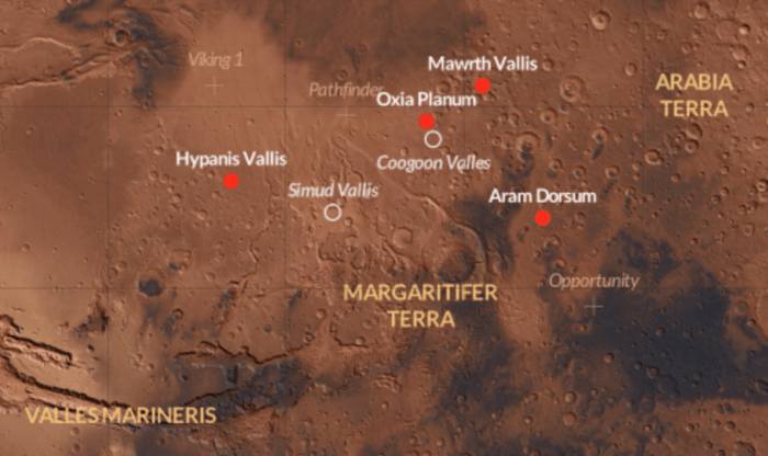
The site selection process has been under way since late 2013, when the science community was asked to propose candidates. In October 2014, four candidates were chosen by the Landing Site Selection Working Group. Now this month, October 2015, the same group met to determine two candidate sites that conform best to both the engineering constraints of descent and landing, and the best possible scientific return of the mission. But their preference for now is Oxia Planum. The team will continue to debate the merits and safety of the proposed sites.
ExoMars rover 2018 landing site candidates. Credit: ESA/CartoDB.
ESA said that all four sites that have been under study – Aram Dorsum, Hypanis Vallis, Mawrth Vallis and Oxia Planum – show evidence of having been influenced by water in the past, and are likely representative of global processes operating in the Red Planet’s early history.
Additionally, all locations offer the opportunity of landing at a scientifically interesting site or finding one within a 1 km drive from the touchdown point, with numerous targets accessible along a typical 2 km traverse planned for the mission of 218 martian days (each 24 hours 37 minutes).
The ExoMars mission is a dual mission with one part launching in 2016 (the Trace Gas Orbiter plus an Entry, Descent and Landing Demonstrator Module) and the rover tentatively scheduled to launch in 2018. As final site selection comes closer, the scientists involved with the mission are anticipating the mission. Professor Andrew Coates who leads the ExoMars PanCam team for the 2018 rover tweeted this today:
ExoMars will land on clays in old region – possible delta – great place to drill, can't wait for PanCam images https://t.co/Hi0gHk46z1
Doesn’t it feel like the Universe is perfectly tuned for life? Actually, it’s a horrible hostile place, delivering the bare minimum for human survival.
Consider that incomprehensible series of events that brought you to this moment. In a way that we still don’t understand, a complex mix of chemicals came together in just the right combination to kick off the evolution of life.
Generation after generation of bacteria, insects, fish, lizards, mammals and eventually humans somehow successfully found a buddy and passed along their genetic material to another generation. Clever humans invented computers, the internet, YouTube, and somehow you found your way to this exact video, to hear these words. Whoa.
It’s amazing to consider the Universe we live in, and how it’s perfectly tuned for life. If just a single variable was a little bit different, life as we know it probably wouldn’t exist. Gravity might be a repulsive force. Pokemons might catch you.
Doesn’t it feel like the Universe was created especially for us? I mean, didn’t I already tell you that we’re all the center of the Universe?
I’m sad to say, but this couldn’t be further from the truth. The reality is that the Universe is 100% completely inhospitable. Well, apart from a thin layer on the surface of our Earth, but that’s got to be a rounding error. A fraction of a fraction of a fraction of the teeniest percent of the volume of the Universe. The rest of the Universe is bunk.
If I was plucked out of our cozy environment and dropped into the near vacuum of pretty much anywhere else, the only resource would be a handful of hydrogen atoms. And what can you do with a few hydrogen atoms? Nothing. It might even give Bear Grylls a run for his money. He might have a little more trouble on a star’s surface, crisping up in a heartbeat.
Into a black hole? Surface of a neutron star? Near an exploding supernova? Please enjoy the crushing pressures and hellish temperatures of Venus, or the freezing irradiated surface of Mars.
Earth itself is mostly a deathtrap. Travel down a few kilometers and you’d bake and crush from the rising temperatures of the Earth’s interior. Travel up and the air gets thin, cold and killy. In fact, without our technology heating, cooling, or helping us breathe, we wouldn’t last more than a few days on most of the planet.
Panorama of the part of Mars, from Sol 173. Credit: NASA/JPL/Caltech/Malin Space Science Systems. Image editing by
When you think about the landscape of time, we even live in a brief thumbnail of a moment when Earth is hospitable. Over the next few billion years, the Sun is going to heat up to the point that the surface of Earth will resemble the surface of Venus. And then the last hospitable hidey-hole in the entire Universe, that we know of, will wink out. The Universe is as inhospitable as it could possibly be. That is, without being completely inhospitable.
Especially when you consider the timeframes, and the long future when all the stars have died, where there’s nothing but black holes and frozen matter, and the Universe finally ditches that rounding error, and becomes 100% purely inhospitable.
Cosmologists use a term known as the anthropic principle to explain this very special moment we find ourselves in. There’s the greater anthropic principle that says the Universe wouldn’t be here without us to observe it, but that seems nutty and egotistical.
The lesser anthropic principle says that if the Universe turned out any differently, we wouldn’t be here to observe it.
First ever image of Earth Taken by Mars Color Camera aboard India’s Mars Orbiter Mission (MOM) spacecraft while orbiting Earth and before the Trans Mars Insertion firing on Dec. 1, 2013. Image is focused on the Indian subcontinent. Credit: ISRO
Imagine you threw a dart out the window of an airplane and it landed in a tiny spot on the surface of the Earth. What were the chances that it would land there? Almost zero. What a lucky spot.
You can imagine all kinds of other even more inhospitable Universes, where the conditions were never good enough for life to evolve, and so intelligent civilizations could never even ask the question, “Is Our Universe Perfect for Life.”
So when you look out across a meadow in the springtime. The birds are chirping, and there’s new growth everywhere, don’t forget about the boiling rock magma beneath your feet, the frigid air and then vacuum above your head, and the whole Universe of burning, radiating, impacting objects trying their best to kill you.
Of all the extreme environments in the Universe, which ones do you find most fascinating? Tell us in the comments below.