Special Guest: Dr. Carolyn Porco is the leader of the Cassini Imaging Science team and the Director of the Cassini Imaging Central Laboratory for Operations (CICLOPS) at the Space Science Institute in Boulder, Colorado.
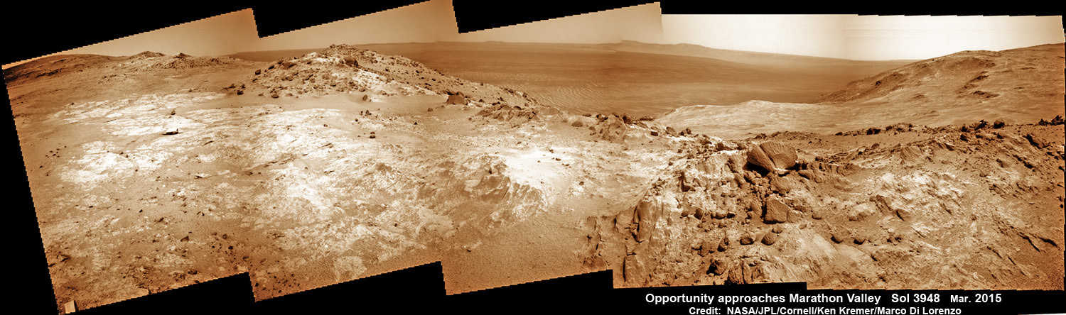
Panoramic view from NASA’s Opportunity rover looking down the floor of Marathon Valley and out to the vast expense of Endeavour Crater. Marathon Valley holds significant deposits of water altered clay minerals. This composite photo mosaic shows the rover’s robotic arm reaching out at left to investigate Martian rocks holding clues to the planets watery past, and robot shadow and wheel tracks visible at right. The mosaic combines a flattened fisheye hazcam image at left with a trio of navcam camera images taken on Sol 4144 (Sept. 20, 2015) and colorized. Credit: NASA/JPL/Cornell/Ken Kremer/kenkremer.com/Marco Di Lorenzo
As NASA’s Opportunity rover approaches the 12th anniversary of landing on Mars, her greatest science discoveries yet are likely within grasp in the coming months since she has successfully entered Marathon Valley from atop a Martian mountain and is now prospecting downhill for outcrops of water altered clay minerals.
The valley is the gateway to alien terrain holding significant caches of the water altered minerals that formed under environmental conditions conducive to support Martian microbial life forms, if they ever existed. But as anyone who’s ever climbed down a steep hill knows, you have to be extra careful not to slip and slide and break something, no matter how beautiful the view is – Because no one can hear you scream on Mars! See the downward looking valley view above.
After a years long Martian mountain climbing and mountain top exploratory trek, Opportunity entered a notch named Marathon Valley from atop a breathtakingly scenic ridge overlook atop the western rim of Endeavour Crater.
Marathon Valley measures about 300 yards or meters long and cuts downhill through the west rim of Endeavour crater from west to east. Endeavour crater spans some 22 kilometers (14 miles) in diameter.
See our photo mosaics illustrating Opportunity’s view around and about Marathon Valley and Endeavour Crater, created by the image processing team of Ken Kremer and Marco Di Lorenzo.
Our mosaic above affords a downward looking view from Marathon Valley on Sol 4144, Sept. 20. It uniquely combines raw images from the hazcam and navcam cameras to gain a wider perspective panoramic view of the steep walled valley, and also shows the rover at work stretching out the robotic arm to potential clay mineral rock targets at left. Opportunity’s shadow and wheel tracks are visible at right.
Mosaic view from Opportunity rover looking along the high walls and down the floor of Marathon Valley with deposits of water altered clay minerals and out to the vast expense of Endeavour Crater. This navcam camera photo mosaic was assembled from images taken on Sol 4159 (Oct. 5, 2015) and colorized. Credit: NASA/JPL/Cornell/Marco Di Lorenzo/Ken Kremer/kenkremer.com
In late July, Opportunity began the decent into the valley from the western edge and started investigating scientifically interesting rock targets by conducting a month’s long “walkabout” survey ahead of the upcoming frigid Martian winter – the seventh since touchdown at Meridiani Planum in January 2004.
The walkabout was done to identify targets of interest for follow up scrutiny in and near the valley floor. Opportunity’s big sister Curiosity conducted a similarly themed “walkabout” at the base of Mount Sharp near her landing site located on the opposite side of the Red Planet.
“The valley is somewhat like a chute directed into the crater floor, which is a long ways below. So it is somewhat scary, but also pretty interesting scenery,” writes Larry Crumpler, a science team member from the New Mexico Museum of Natural History & Science, in a mission update.
“Its named Marathon Valley because the rover traveled one marathon’s distance to reach it,” Prof. Ray Arvidson, the rover Deputy Principal Investigator of Washington University told Universe Today.
The NASA rover exceeded the distance of a marathon on the surface of Mars on March 24, 2015, Sol 3968. Opportunity has now driven over 26.46 miles (42.59 kilometers) over nearly a dozen Earth years.
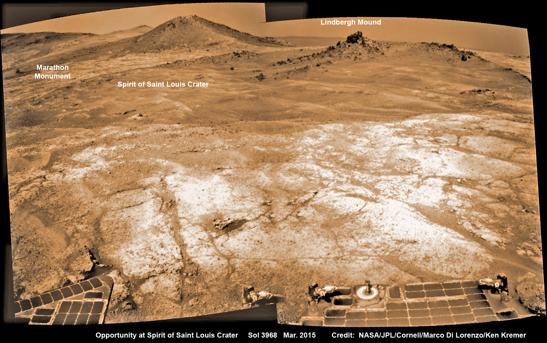
Opportunity’s view (annotated) on the day the NASA rover exceeded the distance of a marathon on the surface of Mars on March 24, 2015, Sol 3968 with features named in honor of Charles Lindbergh’s historic solo flight across the Atlantic Ocean in 1927. Rover stands at Spirit of Saint Louis Crater near mountaintop at Marathon Valley overlook and Martian cliffs at Endeavour crater holding deposits of water altered clay minerals. This navcam camera photo mosaic was assembled from images taken on Sol 3968 (March 24, 2015) and colorized. Credit: NASA/JPL/Cornell/Marco Di Lorenzo/Ken Kremer/kenkremer.com
Now for the first time in history, a human emissary has arrived to conduct an up close inspection of and elucidate clues into this regions potential regarding Martian habitability.
The ancient, weathered slopes around Marathon Valley hold a motherlode of ‘phyllosilicate’ clay minerals, based on data obtained from the extensive Mars orbital measurements gathered by the CRISM spectrometer on NASA’s Mars Reconnaissance Orbiter (MRO) – accomplished earlier at the direction of Arvidson.
‘Hinners Point’ Above Floor of ‘Marathon Valley’ on Mars. This Martian scene shows contrasting textures and colors of “Hinners Point,” at the northern edge of “Marathon Valley,” and swirling reddish zones on the valley floor to the left. Credit: NASA/JPL-Caltech/Cornell Univ./Arizona State Univ.
Initially the science team was focused on investigating the northern region of the valley while the sun was still higher in the sky and generating more power for research activities from the life giving solar arrays.
“We have detective work to do in Marathon Valley for many months ahead,” said Opportunity Deputy Principal Investigator Ray Arvidson, of Washington University in St. Louis.
But now that the rover is descending into a narrow valley with high walls, the rovers engineering handlers back on Earth have to exercise added caution regarding exactly where they send the Opportunity on her science forays during each sols drive, in order to maintain daily communications.
The high walls to the north and west of the valley ridgeline has already caused several communications blackouts for the “low-elevation Ultra-High-Frequency (UHF) relay passes to the west,” according to the JPL team controlling the rover.
Indeed on two occasions in mid September – coinciding with the days just before and after our Sol 4144 (Sept. 20) photo mosaic view above, “no data were received as the orbiter’s flight path was below the elevation on the valley ridgeline.
On Sept 17 and Sept. 21 “the high ridgeline of the valley obscured the low-elevation pass” and little to no data were received. However the rover did gather imagery and spectroscopic measurements for later transmission.
Now that winter is approaching the rover is moving to the southern side of Marathon Valley to soak up more of the sun’s rays from the sun-facing slope and continue research activities.
“During the Martian late fall and winter seasons Opportunity will conduct its measurements and traverses on the southern side of the valley,” says Arvidson.
“When spring arrives the rover will return to the valley floor for detailed measurements of outcrops that may host the clay minerals.”
The shortest-daylight period of this seventh Martian winter for Opportunity will come in January 2016.
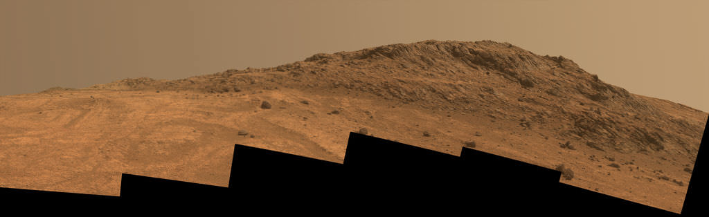
NASA’s Opportunity Rover scans along a spectacular overlook toward Marathon Valley on March 3, 2015, showing flat-faced rocks exhibiting a completely new composition from others examined earlier. Marathon Valley and Martian cliffs on Endeavour crater hold deposits of water altered clay minerals. This navcam camera photo mosaic was assembled from images taken on Sol 3948 (March 3, 2015) and colorized. Credit: NASA/JPL/Cornell/Ken Kremer/kenkremer.com/Marco Di Lorenzo
As of today, Sol 4168, Oct, 15, 2015 Opportunity has taken over 206,300 images and traversed over 26.46 miles (42.59 kilometers).
Stay tuned here for Ken’s continuing Earth and planetary science and human spaceflight news.
Nearly 12 Year Traverse Map for NASA’s Opportunity rover from 2004 to 2015
This map shows the entire path the rover has driven during almost 12 years and more than a marathon runners distance on Mars for over 4163 Sols, or Martian days, since landing inside Eagle Crater on Jan 24, 2004 – to current location at the western rim of Endeavour Crater and descending into Marathon Valley. Rover surpassed Marathon distance on Sol 3968 and marked 11th Martian anniversary on Sol 3911. Opportunity discovered clay minerals at Esperance – indicative of a habitable zone – and is currently searching for more at Marathon Valley. Credit: NASA/JPL/Cornell/ASU/Marco Di Lorenzo/Ken Kremer/kenkremer.com
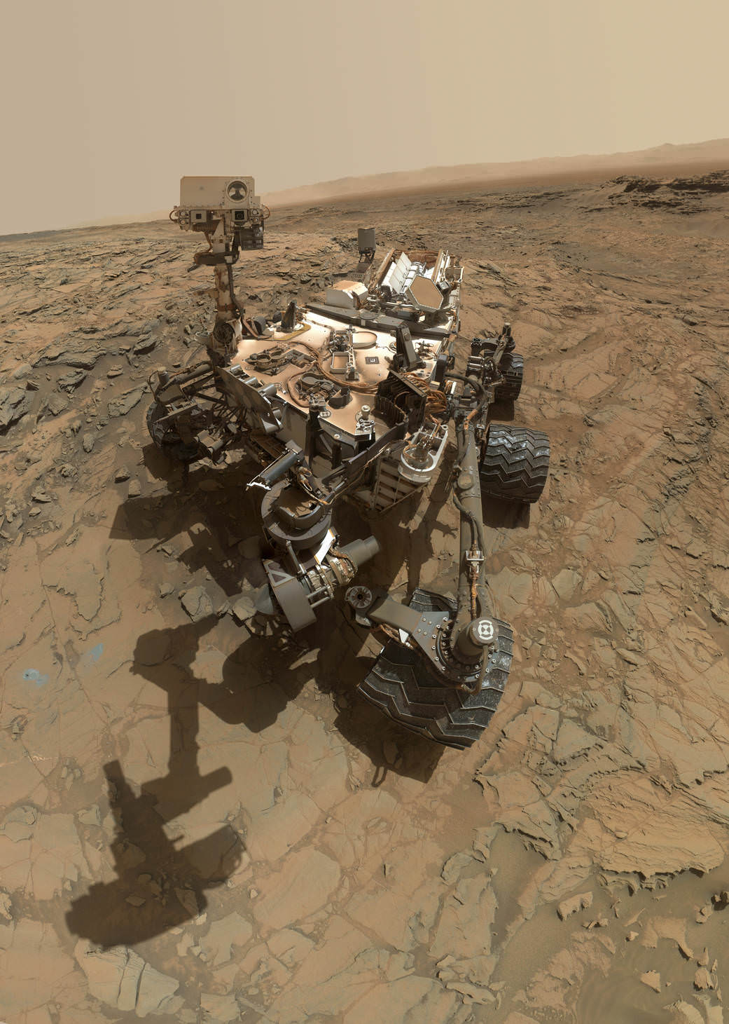
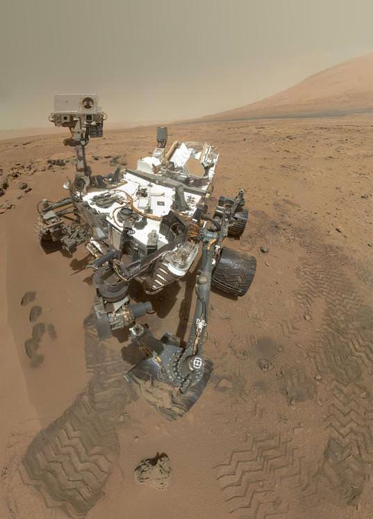
This self-portrait of NASA's Curiosity Mars rover shows the vehicle at the "Big Sky" site. Credit: NASA/JPL-Caltech/MSSS
Every time the Curiosity rover takes a ‘selfie’ on Mars, we get the same questions: “How was this picture taken?” “Why isn’t the rover’s arm or the camera visible in this picture?” “In all of Curiosity’s selfies, the camera mast is never visible… why?” And (sigh) “What is NASA hiding???”
The answer is simple and quite logical. Look any selfie image you’ve taken. Does your hand show up in the picture?
No, because it is behind the camera.
The same is true with the rover’s arm. For the most part, it is behind the camera, so it isn’t part of the picture. In your own selfies, if you’ve done a good job of positioning things, your arm doesn’t appear in the photo either. For example, take a look at this selfie taken last night by Astronomy Cast co-host Pamela Gay of her co-host (and Universe Today publisher) Fraser Cain, along with their fellow speakers at the Next Frontiers Symposium at Ohio State University.
You’ll notice Pamela’s arm isn’t showing, even though she took the picture of herself, just like the rover takes pictures of itself.
Just think of the rover’s arm as the ultimate interplanetary selfie stick. The best selfie-stick pictures are where the stick doesn’t show up in the image and it appears you had your own photographer. That’s what happens with the Curiosity rover self-portraits.
It’s important to note that while the rover selfies look like they are just one single image taken by the wide-angle camera on the rover, it is actually a series of individual images stitched together. The picture above is made from dozens of images the rover took of itself with the Mars Hand Lens Imager (MAHLI) camera at the end of the rover’s robotic arm. Curiosity moves its robotic arm around and over itself and the ground, taking pictures from every angle. These pictures are then stitched, just like panoramic images are put together to form a complete image of your total view. The rover’s arm isn’t long enough to make the camera’s field of view big enough to get the entire rover in one shot (similar to how it works if you hold your camera/phone close to your face you only get one feature, like your nose or eyes, not your entire body.)
Update: As for the questions of why the rover’s arm doesn’t show up in these rover selfie images, I conferred with Guy Webster from JPL and he said that portions of the arm do show up in some of the images used to create the selfie shots, but the portion of the arm pictured is very limited, and the team feels it would be even more confusing to include the small parts of the arm that are in some of the images and so have decided to leave it out entirely.
“Some of the component images do indeed show glimpses of the arm,” Webster said via email. “There’s selectivity in choosing which parts of which component frames to use in assembling the mosaic, to avoid having discontinuous bits of arm in the scene. That would cause confusion even quicker than making choices that leave out the arm.”
For example, here is one image from the series of pictures taken by the MAHLI to create the selfie, and it shows just a small piece of the arm, near the “shoulder”:
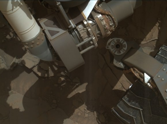
A small portion of the Curiosity rover’s robotic arm (the white ‘tube’ on the top left of the image) shows up in one of the original raw images used to create the montage ‘selfie.’ Credit: NASA/JPL-Caltech/MSSS.
You can see the entire collection of MAHLI images from Sol 1126 (Oct. 6, 2015) here. You can see how few images show parts of the arm, and how little of the arm shows up in the ones that do.
For the most part, though, because of the flexibility of the robotic arm and the way it is able to move, the arm ends up behind the camera. As Curiosity’s Engineering Camera Team Leader Justin Maki explains in the video below, “The rover is imaging the deck while the arm is behind the camera, and then to image the ground … again the arm is behind the camera when taking these pictures. When we stitch them all together, you don’t see the arm in any of the pictures.”
Click on the image to start the video (which shows very well why the arm isn’t in most of the shots):
It’s interesting to note, that while the lead image above — the latest rover selfie — does not include the rover’s robotic arm, the shadow of the arm is visible on the ground. You’ll notice there seems to be an extra “joint” in the arm, which is just part of the image editing, particularly the stacking of the images where the ground is, where the image editors used more than one image for that area. For the selfie image below, taken in 2012, the imaging team chose not to include any shadow of the arm.
A color self-portrait photo of Curiosity standing on Mars, on sol 84 (October 31, 2012). The photo is a mosaic of images shot with MAHLI, the camera on the end of the robotic arm. Credit: NASA/JPL/MSSS.
Why does the rover imaging team take these rover selfies? Are they just joining in on the selfie craze here on Earth?
These images are actually a great way for the rover team to look at all the components on Curiosity and make sure everything looks like it’s in good shape. The wheels are of particular interest because there has been some damage to them from driving over sharp rocks. These images also document various areas where the rover has worked, and often include things like the holes the rover has drilled into the Martian rocks and soil.
Emily Lakdawalla at The Planetary Society has written an extremely detailed post on how the rover takes self-portraits. She created this composite image of the 72 individual frames the Mars Hand Lens Imager (MAHLI) had to take in order to cover the 360-degree view showing the rover’s underside, a “belly selfie“:
Curiosity’s arm-mounted MAHLI camera took 72 individual photos over a period of about an hour in order to cover the entire rover and a lower hemisphere including 360 degrees around the rover and more than 90 degrees of elevation. It took 2 tiers of 20 images to cover the entire horizon, and fewer images at lower elevations to cover the bottom of the image sphere. The arm was kept out of most of the images but it was impossible to keep the arm’s shadow from falling on the ground in positions immediately in front of the rover. Credit: NASA/JPL/MSSS/Emily Lakdawalla.
Here’s another longer video from JPL that explains all the rover’s cameras.
A mosaic of images from NASA’s Curiosity rover shows what appears to be a “selfie” with a Martian mountain (Aeolis Mons)in the background. Credit: NASA/JPL-Caltech /MSS/ Image editing by Jason Major.
This self-portrait of NASA's Curiosity Mars rover shows the vehicle at the "Big Sky" site. Credit: NASA/JPL-Caltech/MSSS
This self-portrait of NASA’s Curiosity Mars rover shows the vehicle at the “Big Sky” site, where its drill collected the mission’s fifth taste of Mount Sharp, at lower left corner. The scene combines images taken by the Mars Hand Lens Imager (MAHLI) camera on Sol 1126 (Oct. 6, 2015). Credit: NASA/JPL-Caltech/MSSS
See below navcam drilling photo mosaic at Big Sky[/caption]
NASA’s Curiosity rover has managed to snap another gorgeous selfie while she was hard at work diligently completing her newest Martian sample drilling campaign – at the ‘Big Sky’ site at the base of Mount Sharp, the humongous mountain dominating the center of the mission’s Gale Crater landing site – which the science team just confirmed was home to a life bolstering ancient lake based on earlier sample analyses.
And the team is already actively planning for the car sized robots next drill campaign in the next few sols, or Martian days!
Overall ‘Big Sky’ marks Curiosity’s fifth ‘taste’ of Mount Sharp – since arriving at the mountain base one year ago – and eighth drilling operation since the nail biting Martian touchdown in August 2012.
NASA’s newly published self-portrait was stitched from dozens of images taken at Big Sky last week on Oct. 6, 2015, or Sol 1126, by the high resolution Mars Hand Lens Imager (MAHLI) color camera at the end of the rover’s 7 foot long robotic arm. The view is centered toward the west-northwest.
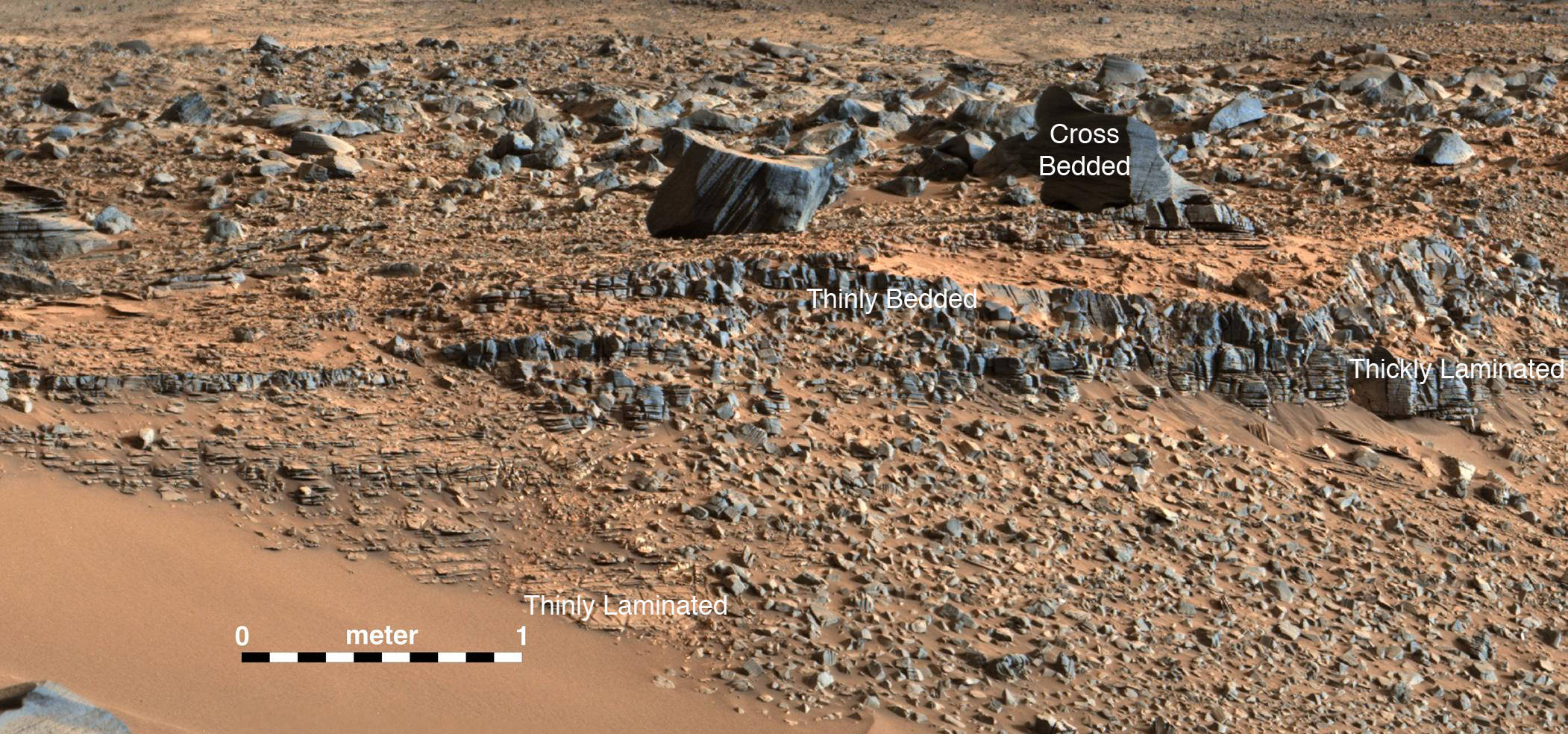
At Big Sky, the Curiosity Mars Science Laboratory (MSL) bored into an area of cross-bedded sandstone rock in the Stimson geological unit on Sept. 29, or Sol 1119. Stimson is located on the lower slopes of Mount Sharp inside Gale Crater.
NASA Curiosity rover reaches out with robotic arm to drill into cross-bedded sandstone rock at ‘Big Sky’ target on Sol 1119, Sept. 29, 2015, in this photo mosaic stitched from navcam camera raw images and colorized. Big Sky is located in the Stimson unit on the lower slopes of Mount Sharp inside Gale Crater. Credit: NASA/JPL/Ken Kremer/kenkremer.com/Marco Di Lorenzo
“Success! Our drill at “Big Sky” went perfectly!” wrote Ryan Anderson, a planetary scientist at the USGS Astrogeology Science Center and a member of the Curiosity ChemCam team.
The drill hole is seen at the lower left corner of the MAHLI camera selfie and appears grey along with grey colored tailing – in sharp contrast to the rust red surface. The hole itself is 0.63 inch (1.6 centimeters) in diameter.
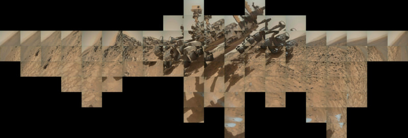
Another panoramic view of the ‘Big Sky’ location shot from the rover’s eye perspective with the mast mounted Navcam camera, is shown in our photo mosaic view herein and created by the image processing team of Ken Kremer and Marco Di Lorenzo. The navcam mosaic was stitched from raw images taken up to Sol 1119 and colorized.
“With Big Sky, we found the ordinary sandstone rock we were looking for,” said Curiosity Project Scientist Ashwin Vasavada, in a statement.
The Big Sky drilling operation is part of a coordinated multi-step campaign to examine different types of sandstone rocks to provide geologic context.
“It also happens to be relatively near sandstone that looks as though it has been altered by fluids — likely groundwater with other dissolved chemicals. We are hoping to drill that rock next, compare the results, and understand what changes have taken place.”
Per normal operating procedures, the Big Sky sample was collected for analysis of the Martian rock’s ingredients in the rover’s two onboard laboratories – the Chemistry and Mineralogy X-Ray diffractometer (CheMin) and the Sample Analysis at Mars (SAM) instrument suite.
“We are all eagerly looking forward to the CheMin results from Big Sky to compare with our previous results from “Buckskin”! noted Anderson.
Curiosity extends robotic arm and conducts sample drilling at “Buckskin” rock target at bright toned “Lion” outcrop at the base of Mount Sharp on Mars, seen at right. Gale Crater eroded rim seen in the distant background at left, in this composite multisol mosaic of navcam raw images taken to Sol 1059, July 30, 2015. Navcam camera raw images stitched and colorized. Inset: MAHLI color camera up close image of full depth drill hole at “Buckskin” rock target on Sol 1060. Credit: NASA/JPL-Caltech/MSSS/Ken Kremer/kenkremer.com/Marco Di Lorenzo
This past weekend, Curiosity successfully fed pulverized and sieved samples of Big Sky to the inlet ports for both CheMin and SAM on the rover deck.
“The SAM analysis of the Big Sky drill sample went well and there is no need for another analysis, so the rest of the sample will be dumped out of CHIMRA on Sol 1132,” said Ken Herkenhoff, Research Geologist at the USGS Astrogeology Science Center and an MSL science team member, in a mission update.
Concurrently the team is hard at work readying the rover for the next drill campaign within days, likely at a target dubbed “Greenhorn.”
So the six wheeled rover drove about seven meters to get within range of Greenhorn.
With the sample deliveries accomplished, attention shifted to the next drilling campaign.
Today, Wednesday, Oct. 14, or Sol 1133, Curiosity was commanded “to dump the “Big Sky” sample and “thwack” CHIMRA (the Collection and Handling for in-Situ Martian Rock Analysis) to clean out any remnants of the sample,” wrote Lauren Edgar, a Research Geologist at the USGS Astrogeology Science Center and a member of MSL science team, in a mission update.
The ChemCam and Mastcam instruments are simultaneously making observations of the “Greenhorn” and “Gallatin Pass” targets “to assess chemical variations across a fracture.”
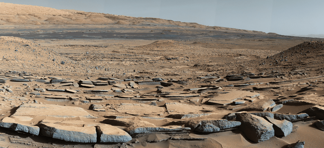
This Martian “postcard” comes after Mars Curiosity drilled its eighth hole on the Red Planet. This composite image looking toward the higher regions of Mount Sharp was taken on September 9, 2015, by NASA’s Curiosity rover. In the foreground — about 2 miles (3 kilometers) from the rover — is a long ridge teeming with hematite, an iron oxide. Credits: NASA/JPL-Caltech/MSSS
Curiosity has already accomplished her primary objective of discovering a habitable zone on the Red Planet – at the Yellowknife Bay area – that contains the minerals necessary to support microbial life in the ancient past when Mars was far wetter and warmer billions of years ago.
As of today, Sol 1133, October 14, 2015, she has driven some 6.9 miles (11.1 kilometers) kilometers and taken over 274,600 amazing images.
Stay tuned here for Ken’s continuing Earth and planetary science and human spaceflight news.
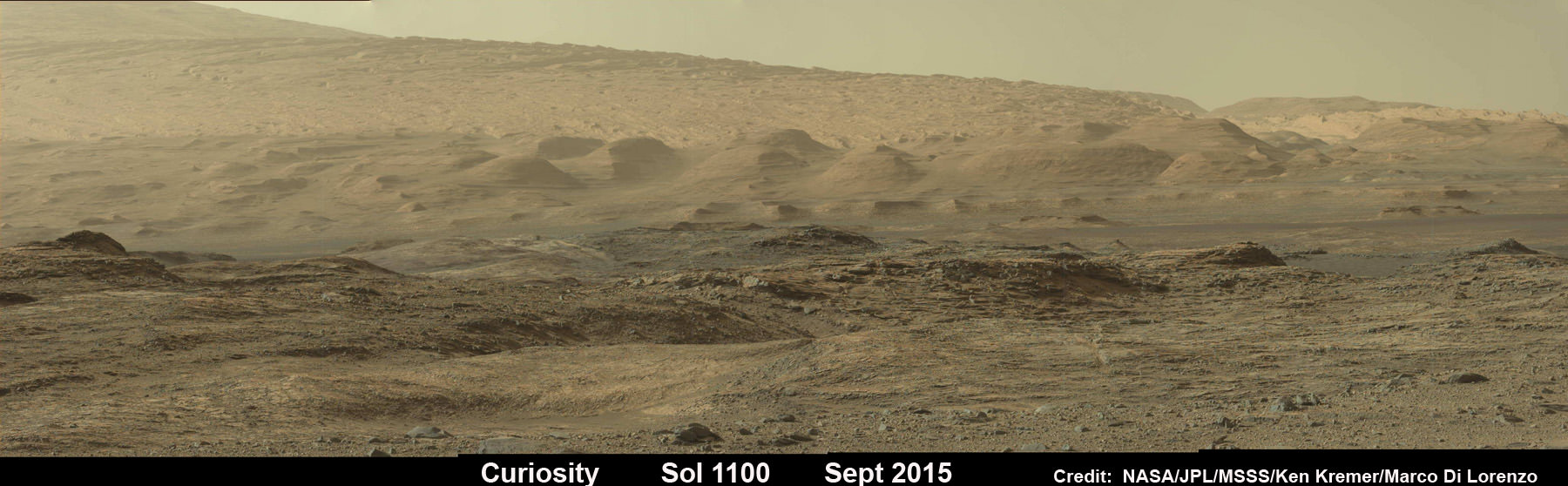
Curiosity looks toward fabulous canyons and buttes at the base of Mount Sharp from the Stimson sand dunes on Mars on Sol 1100, Sept. 10 2015 in this photo mosaic stitched from Mastcam color camera raw images. Credit: NASA/JPL/MSSS/Ken Kremer/kenkremer.com/Marco Di Lorenzo
Scene from ‘The Martian’ starring Matt Damon as NASA astronaut Mark Watney contemplating magnificent panoramic vista while stranded alone on Mars. Credits: 20th Century Fox
Scene from ‘The Martian’ starring Matt Damon as NASA astronaut Mark Watney contemplating magnificent panoramic vista while stranded alone on Mars.
Credits: 20th Century Fox
See real Martian maps and flyover video from DLR and NSA below
Story/imagery updated[/caption]
Go now and experience Hollywood’s blockbuster new space epic ‘The Martian’ helmed by world renowned director Ridley Scott and starring Matt Damon as the protagonist, NASA astronaut Mark Watney. And you can follow Watney’s dramatic fictional path across the Red Planet in newly released real photos and a flyover video of the region, from DLR and NASA, as it looks today.
‘The Martian’ is a mesmerizingly enjoyable cinematic triumph for everyone that’s all about science, space exploration and one man’s struggle to survive while left totally isolated on the Red Planet in the face of seemingly insurmountable odds – relying on his wits alone to endure “on a planet where nothing grows” while hoping somehow for a rescue by NASA four years in the future.
The movie combines compelling and plausible storytelling with outstanding special effects that’s clearly delighting huge audiences worldwide with a positive and uplifting view of what could be achieved in the future – if only we really put our minds to it!
Based on the bestselling book by Andy Weir, ‘The Martian’ movie from 20th Century Fox tells the spellbinding story of how NASA astronaut Mark Watney is accidentally stranded on the surface of Mars during the future Ares 3 manned expedition in 2035, after a sudden and unexpectedly fierce dust storm forces the rest of the six person crew – commanded by Jessica Chastain as Commander Lewis – to quickly evacuate after they believe he is dead.
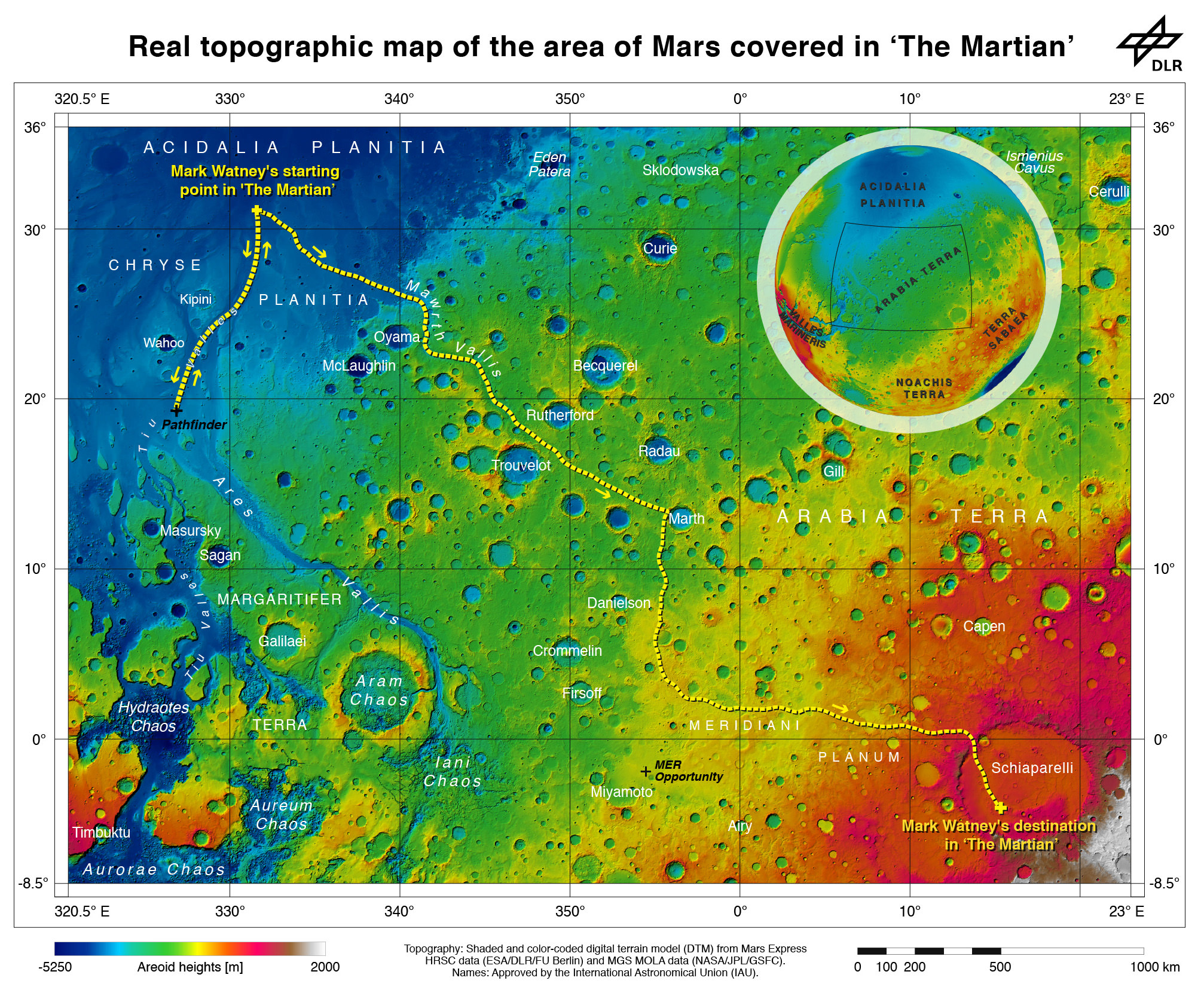
Real topographic map of the area of Mars covered in ‘The Martian.’ Follow the path of Mark Watney’s fictional endeavors from the Ares 3 landing site at Acidalia Planitia to NASA’s real Mars Pathfinder lander at the mouths of Ares Vallis and Tiu Valles and back, and finally to the Ares 4 landing site at Schiaparelli Crater. Credit: DLR/ESA/NASA
Now you can follow the fictional exploits of Mark Watney’s stunningly beautiful trail across the real Mars through a set of newly released maps, imagery and a 3D video created by the DLR, the German Aerospace Agency, and NASA – and based on photos taken by the European Space Agency’s Mars Express orbiter and NASA’s Mars Reconnaissance Orbiter (MRO).
DLR’s stunning 3D overflight video sequence was created from a dataset of 7300 stereo images covering roughly two-and-a-half million square kilometres of precisely mapped Martian landscape captured over the past 12 years by Mars Express High Resolution Stereo Camera (HRSC). The electric score is by Stephan Elgner.
Video Caption: Following the path of The Martian – video generated using images acquired by the Mars Express orbiter. Scientists from German Aerospace Center, DLR– who specialise in producing highly accurate topographical maps of Mars – reconstructed Watney’s route using stereo image data acquired by the High Resolution Stereo Camera on board European Space Agency’s #MarsExpress spacecraft. They then compiled this data into a video that shows the spectacular landscape that the protagonist would see ‘in the future’ on his trek from Ares 3 at Acidalia Planitia/Chryse Planitia to Ares 4 at Schiaparelli Crater. Credit: DLR/ESA
Ridley Scotts ‘The Martian’ takes place mostly on the surface of the Red Planet and is chock full of breathtakingly beautiful panoramic vistas. In the book you can only imagine Mars. In the movie Scott’s talents shine as he immerses you in all the action on the alien world of Mars from the opening scene.
Starting with the landing site for Watney’s Ares 3 mission crew at Acidalia Planitia, the book and movie follows his triumphs and tribulations, failures and successes as he logically solves one challenging problem after another – only to face increasingly daunting and unexpected hurdles as time goes by and supplies run low.
The DLR route map shows a real topographic view of Watney’s initial journey back and forth from the fictional Ares 3 landing site to the actual landing site of NASA’s 1997 Mars Pathfinder lander and Sojourner rover mission at the mouth of Ares Vallis.
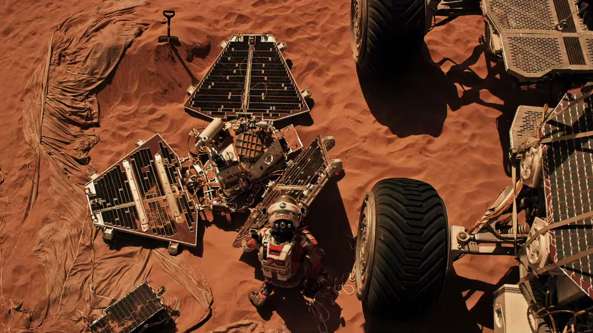
Mark Watney arrives at the NASA’s 1997 Pathfinder lander to gather communications gear in a scene from “The Martian.” People and technology from NASA’s Jet Propulsion Laboratory aid fictional astronaut Mark Watney during his epic survival story in “The Martian.” Credits: 20th Century Fox
The map continues with Watney’s months-long epic trek to the fictional landing site of Ares 4 Mars Ascent Vehicle (MAV) spacecraft at Schiaparelli Crater, by way of Marth Valles and other Martian landmarks, craters and valleys.
At the request of Andy Weir, the HiRISE camera on NASA’s MRO orbiter took photos of the Martian plain at the Ares 3 landing site in Acidalia Planitia, which is within driving distance from the Pathfinder lander and Sojourner rover in the book and movie.
This May 2015 image from the HiRISE camera on NASA’s Mars Reconnaissance Orbiter shows a location on Mars associated with the best-selling novel and Hollywood movie, “The Martian.” It is in a region called Acidalia Planitia, at the landing site for the science-fiction tale’s Ares 3 mission. For the story’s central character, Acidalia Planitia is within driving distance from where NASA’s Mars Pathfinder, with its Sojourner rover, landed in 1997. Credits: NASA/JPL-Caltech/Univ. of Arizona
The Martian is all about how Watney uses his botany, chemistry and engineering skills to “Science the sh** out of it” to grow food and survive until the hoped for NASA rescue.
Learning how to live off the land will be a key hurdle towards enabling NASA’s real strategy for long term space voyages on a ‘Journey to Mars’ and back.
‘The Martian’ is a must see movie that broadly appeals to space enthusiasts and general audiences alike who can easily identify with Watney’s ingenuity and will to live.
Since its worldwide premiere on Oct. 2, ‘The Martian’ has skyrocketed to the top of the US box office for the second weekend in a row, hauling in some $37.3 million. The total domestic box office receipts now top $108 million and rockets to over $228 million worldwide in the first 10 days alone.
I absolutely loved ‘The Martian’ when I first saw the movie on opening weekend. And enjoyed it even more the second time, when I could pick up a few details I missed the first time around.
Matt Damon stars as NASA astronaut Mark Watney in ‘The Martian.’ Credit: 20th Century Fox
The movie begins as the crew evacuates after they believe Watney was killed by the dust storm. Watney actually survived the storm but lost contact with NASA. The film recounts his ingenious years long struggle to survive, figure out how to tell NASA he is alive and send a rescue crew before he starves to death on a planet where nothing grows. Watney’s predicament is a survival lesson to all including NASA.
‘The Martian’ was written by Andy Weir in 2010 and the film could well break the October movie box office record currently held by ‘Gravity.’
The movie closely follows the book, which I highly recommend you read at some point.
By necessity, the 2 hour 20 minute movie cannot capture every event in the book. So there is an abbreviated sense of Watney’s detailed science to survive and lengthy overland trips.
All the heroics and difficulties in traveling to Pathfinder and back and getting communications started, as well as the final month’s long journey to Schiaparelli crater are significantly condensed, but captured in spirit.
The Martian is brilliant and intelligent and rivals Stanley Kubrik’s space epic ‘2001: A Space Odyssey’ as one of the top movies about humanities space exploration quest.
The one big science inaccuracy takes place right at the start with the violent Martian dust storm.
On Mars the atmosphere is so thin that the winds would not be anywhere near as powerful or destructive as portrayed. This is acknowledged by Weir and done for dramatic license. We can look past that since the remainder of the tale portrays a rather realistic architectural path to Mars and vision of how scientists and engineers think. Plus the dust storms can in fact kick up tremendous amounts of particles that significantly block sunlight from impinging on solar energy generating panels.
Personally I can’t wait for the ‘Directors Cut’ with an added 30 to 60 minutes of scenes that were clearly filmed – but not included in the original theatrical release.
THE MARTIAN features a star studded cast that includes Matt Damon, Jessica Chastain, Kristen Wiig, Kate Mara, Michael Pena, Jeff Daniels, Chiwetel Ejiofor, and Donald Glover.
“NASA has endorsed “The Martian’” Jim Green, NASA’s Director of Planetary Sciences, told Universe Today. Green served as technical consultant on the film.
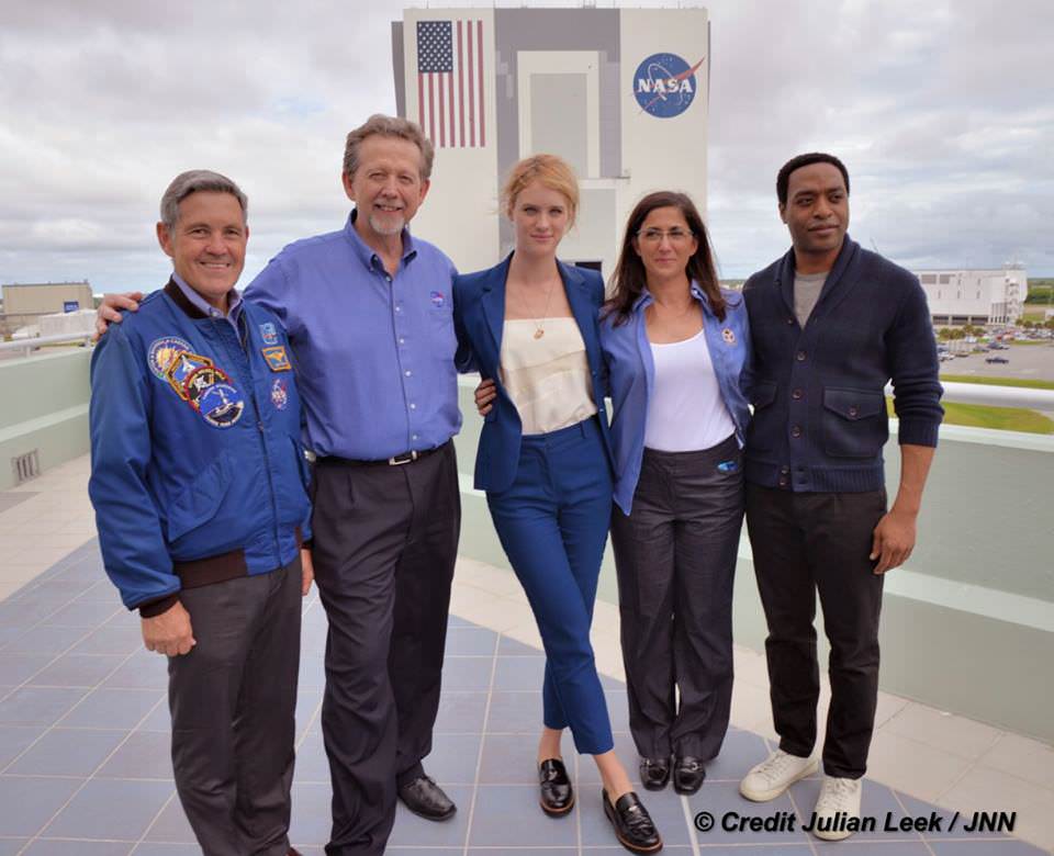
At NASA’s Kennedy Space Center in Florida agency scientists, astronauts actors from the 20th Century Fox Entertainment film “The Martian” met the media. Participants included, from the left, Center Director Bob Cabana, NASA’s Planetary Science Division Director Jim Green, Ph.D., actress Mackenzie Davis, who portrays Mindy Park in the movie, retired NASA astronaut Nicole Stott and actor Chiwetel Ejiofor, who portrays Vincent Kapoor in “The Martian.” Credit: Julian Leek
The DLR film was created by a team led by Ralf Jaumann from the DLR Institute of Planetary Research, Principal Investigator for HRSC. He believes that producing the overflight video was not just a gimmick for a science fiction film:
“Mars generates immense fascination, and our curiosity continues to grow! Many people are interested in our research, and young people in particular want to know what it is really like up there, and how realistic the idea that one day people will leave their footprints on the surface of Mars truly is. The data acquired by HRSC shows Mars with a clarity and detail unmatched by any other experiment. Only images acquired directly on the surface, for instance by rovers like Curiosity, are even closer to reality, but they can only show a small part of the planet. Thanks to this animation, we have even noticed a few new details that we had not seen in a larger spatial context. That is why we made the film – it helps everyone see what it would be like for Watney to travel through these areas… the clouds were the only creative touches we added, because, fortunately, they do not appear in the HRSC data,” according to a DLR statement.
Here’s the second official trailer for The Martian:
As a scientist and just plain Earthling, my most fervent hope is that ‘The Martian’ will inspire our young people to get interested in all fields of science, math and engineering and get motivated to become the next generation of explorers – here on Earth and beyond to the High Frontier to benefit all Mankind.
Stay tuned here for Ken’s continuing Earth and planetary science and human spaceflight news.
A view from the "Kimberley" formation on Mars taken by NASA's Curiosity rover. The strata in the foreground dip towards the base of Mount Sharp, indicating flow of water toward a basin that existed before the larger bulk of the mountain formed. This image was taken by the Mast Camera (Mastcam) on Curiosity on Sol 580 of the mission and has been “white balanced” to adjust for the lighting on Mars make the sky appear light blue. Credits: NASA/JPL-Caltech/MSSS
A view from the “Kimberley” formation on Mars taken by NASA’s Curiosity rover. The strata in the foreground dip towards the base of Mount Sharp, indicating flow of water toward a basin that existed before the larger bulk of the mountain formed. This image was taken by the Mast Camera (Mastcam) on Curiosity on Sol 580 of the mission and has been “white balanced” to adjust for the lighting on Mars make the sky appear light blue. Credits: NASA/JPL-Caltech/MSSS
Story/imagery updated[/caption]
Hot on the heels of NASA’s groundbreaking announcement on Sept. 28 of the discovery that “liquid water flows intermittently” across multiple spots on the surface of today’s Mars, scientists leading NASA’s Curiosity rover mission have confirmed that an ancient lake once filled the Gale Crater site which the robot has been methodically exploring since safely landing back in August 2012 near the base of a layered mountain known as Mount Sharp.
The new research finding from the Curiosity team was just published in the journal Science on Friday, Oct. 9, and boosts the chances that alien life may have taken hold in the form of past or present day Martian microbes.
The article is titled “Wet Paleoclimate of Mars Revealed by Ancient Lakes at Gale Crater,” with John Grotzinger, the former project scientist for the Mars Science Laboratory (MSL) mission at the California Institute of Technology in Pasadena, as lead author of the new report.
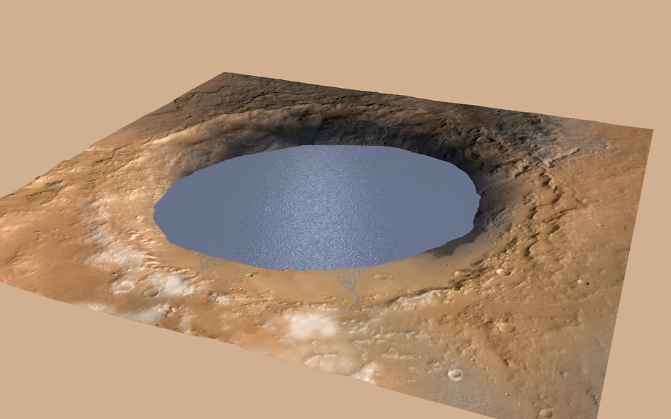
Simulated view of Gale Crater Lake on Mars. This illustration depicts a lake of water partially filling Mars’ Gale Crater, receiving runoff from snow melting on the crater’s northern rim. Credit: NASA/JPL-Caltech/ESA/DLR/FU Berlin/MSSS
The new study is coauthored by four dozen team members intimately involved in Curiosity’s ongoing exploits and “confirmed that Mars was once, billions of years ago, capable of storing water in lakes over an extended period of time.”
“Observations from the rover suggest that a series of long-lived streams and lakes existed at some point between about 3.8 to 3.3 billion years ago, delivering sediment that slowly built up the lower layers of Mount Sharp,” said Ashwin Vasavada, current MSL project scientist at NASA’s Jet Propulsion Laboratory in Pasadena, California, and co-author of the new report, in a statement.
Over the past three years, the Curiosity Mars Science Laboratory rover has been traversing the floor of Gale Crater investigating scores of different rocks and outcrops with her suite of state-of-the-art instruments, and painstakingly analyzing drill samples cored from their interiors with a pair of chemistry labs to elucidate the history of Mars based on NASA’s “follow the water” mantra.
The soundness of NASA Mars exploration strategy has repeatedly borne fruit and is now validated by overwhelming measurements gathered during Curiosity’s epic Martian trek confirming the existence of a lake where Mount Sharp now stands.
Exploring the sedimentary layers of Mount Sharp, which towers 3.4 miles (5.5 kilometers) into the Martian sky, is the primary destination and goal of the rovers long term scientific expedition on the Red Planet.
Since the nail biting touchdown on Aug. 5, 2012, Curiosity has been on a path towards the sedimentary layers at the lower reaches of Mount Sharp at the center of Gale Crater.
Curiosity rover panorama of Mount Sharp captured on June 6, 2014 (Sol 651) during traverse inside Gale Crater. Note rover wheel tracks at left. She will eventually ascend the mountain at the ‘Murray Buttes’ at right later this year. Assembled from Mastcam color camera raw images and stitched by Marco Di Lorenzo and Ken Kremer. Credit: NASA/JPL/MSSS/Marco Di Lorenzo/Ken Kremer-kenkremer.com
The car sized robot arrived at the foothills of Mount Sharp a year ago in September 2014, marking the start of the mountains formal investigation.
But the origin of Mount Sharp has been up for debate.
With the new data, researchers believe that the ancient lake helped fill Gale Crater with sediments deposited in layers over time that formed the foundation for Mount Sharp which now dominates the center of the crater.
“What we thought we knew about water on Mars is constantly being put to the test,” said Michael Meyer, lead scientist for NASA’s Mars Exploration Program at NASA Headquarters in Washington.
“It’s clear that the Mars of billions of years ago more closely resembled Earth than it does today. Our challenge is to figure out how this more clement Mars was even possible, and what happened to that wetter Mars.”
Mars was far wetter and warmer and possessed a much more massive atmosphere billions of years ago than it does today.
An image taken at the “Hidden Valley” site, en-route to Mount Sharp, by NASA’s Curiosity rover. A variety of mudstone strata in the area indicate a lakebed deposit, with river- and stream-related deposits nearby. This image was taken by the Mast Camera (Mastcam) on Curiosity on Sol 703. Credits: NASA/JPL-Caltech/MSSS
Gale Crater lake existed long before Mount Sharp ever formed during that period billions of years ago when the Red Planet was far warmer and wetter.
“Paradoxically, where there is a mountain today there was once a basin, and it was sometimes filled with water,” said Grotzinger, in a statement.
“We see evidence of about 250 feet (75 meters) of sedimentary fill, and based on mapping data from NASA’s Mars Reconnaissance Orbiter and images from Curiosity’s camera, it appears that the water-transported sedimentary deposition could have extended at least 500 to 650 feet (150 to 200) meters above the crater floor.”
Indeed there is additional evidence that the sedimentary deposits from interaction with water may be as thick as one-half mile (800 meters) above the crater floor. However beyond that there is no evidence of hydrated strata further up Mount Sharp.
But for reasons we are still trying to decipher and comprehend, Mars underwent radical climactic change between 3 and 4 billion years ago and was transformed from an ancient wet world, potentially hospitable to life, to a cold, dry desiccated world, rather inhospitable to life, that exists today.
Curiosity’s Panoramic view of Mount Remarkable at ‘The Kimberley Waypoint’ where rover conducted 3rd drilling campaign inside Gale Crater on Mars. The navcam raw images were taken on Sol 603, April 17, 2014, stitched and colorized. Credit: NASA/JPL-Caltech/Ken Kremer – kenkremer.com/Marco Di Lorenzo. Featured on APOD – Astronomy Picture of the Day on May 7, 2014
Unlocking the mysteries, mechanisms and time periods of Mars climate change, loss of a thick atmosphere, ability to sustain liquid surface water and searching for organic compounds and for evidence of past or present habitable zones favorable to life are the questions driving NASA’s Mars Exploration program
Curiosity has already accomplished her primary objective of discovering a habitable zone on the Red Planet – at the Yellowknife Bay area – that contains the minerals necessary to support microbial life in the ancient past when Mars was far wetter and warmer billions of years ago.
NASA’s Curiosity rover looks back to ramp with potential 4th drill site target at ‘Bonanza King’ rock outcrop in ‘Hidden Valley’ in this photo mosaic view captured on Aug. 6, 2014, Sol 711. Inset shows results of brushing on Aug. 17, Sol 722, that revealed gray patch beneath red dust. Note the rover’s partial selfie, valley walls, deep wheel tracks in the sand dunes and distant rim of Gale crater beyond the ramp. Navcam camera raw images stitched and colorized. Credit: NASA/JPL-Caltech/Ken Kremer-kenkremer.com/Marco Di Lorenzo
“We have tended to think of Mars as being simple,” Grotzinger mused. “We once thought of the Earth as being simple too. But the more you look into it, questions come up because you’re beginning to fathom the real complexity of what we see on Mars. This is a good time to go back to reevaluate all our assumptions. Something is missing somewhere.”
As of today, Sol 1129, October 10, 2015, she has driven some 6.9 miles (11.1 kilometers) kilometers and taken over 274,000 amazing images.
Curiosity is at the vanguard of Earth’s fleet of seven robotic missions paving the path for NASA’s plans to send humans on a ‘Journey to Mars’ in the 2030s.
Stay tuned here for Ken’s continuing Earth and planetary science and human spaceflight news.
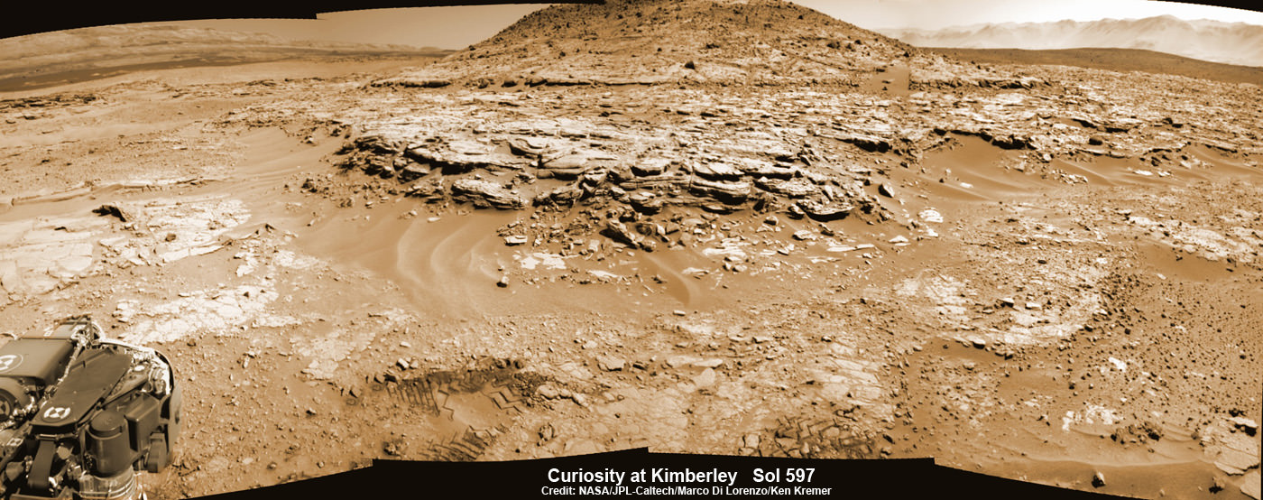
Curiosity Mars rover captured this panoramic view of a butte called “Mount Remarkable” and surrounding outcrops at “The Kimberley ” waypoint on April 11, 2014, Sol 597. Colorized navcam photomosaic was stitched by Marco Di Lorenzo and Ken Kremer. Credit: NASA/JPL-Caltech/Marco Di Lorenzo/Ken Kremer – kenkremer.com
The sky sparkles with the Moon (top, overexposed), Regulus, Venus, Mars, and Jupiter at dawn this morning October 7, 2015.
Tomorrow morning might be a good time to call for extra celestial traffic control. A slip of a crescent Moon will join a passel of planets in the dawn sky for the first of several exciting conjunctions over the next few days.
The scene facing east about 1 1/2 hours before sunrise Thursday morning Oct. 8. Let your eyes delight in the tumble of Moon and planets. Source: Stellarium
In the space of three mornings beginning tomorrow, four planets, the Moon and the star Regulus will participate in six separate conjunctions. Here’s how it’ll play out. Time are shown in UT / Greenwich Mean Time and Central Daylight and 1° equals two full moon diameters:
October 8: Venus 2.5° south of Regulus at 18 UT (1 p.m. CDT)
October 8: Regulus 3.1° north of the moon at 19 UT (2 p.m. CDT)
October 8: Venus 0.6° north of the moon at 20 UT (3 p.m. CDT)
October 9: Mars 3.2° north of the moon at 14 UT (9 a.m. CDT)
October 9: Jupiter 2.5° north of the moon at 21 UT (4 p.m.)
October 11: Mercury 0.8° north of the moon 11 UT (6 a.m. CDT)
The crescent Moon will be near Venus all day Thursday for the Americas until it sets in late afternoon. What a great opportunity to catch sight of the planet in the middle of the day. This binocular view depicts their arrangement around noon CDT Oct. 8, when the planet lies less than 2° from the Moon. Source:: Stellarium
Since several of the events occur in the middle of the afternoon for skywatchers in the Americas, here’s an expanded viewing guide:
* Thursday, October 8: Skywatchers will see Venus pass 2.5° south of Leo’s brightest star Regulus with a cool crescent moon a little more than 3° to the west of the brilliant planet. If you live in Japan and the Far East, you’ll see a splendidly close conjunction of the moon and Venus at dawn on October 9, when the pair will be separated by a hair more than one moon diameter (0.6°). At nearly the same time, the moon will be in conjunction with Regulus.
Observers in Australia and New Zealand will see the Moon occult Venus in a dark sky sky before dawn (or in daylight, depending on exact location) on the 9th. Click HERE for information, times and a map for the event.
Ready to set the alarm again? The following morning, October 9, the moon makes a neat triangle with Jupiter and Mars. Source: Stellarium
* Friday, October 9: An even thinner moon passes about 3° north of Mars in the Americas at dawn and approximately 4° from Jupiter. Watch for the three luminaries to sketch a nifty triangle in the eastern sky 90 minutes to an hour before sunrise. Venus will gaze down at the planetary conclave 10° further west.
There’s not much of the Moon left by Saturday morning the 11th. The knife-edge crescent will hang less than a degree below the planet Mercury 40 minutes before sunrise. Make sure you find a spot with a good eastern horizon. Source: Stellarium
* Sunday, October 11: Mercury, which has quietly taken up residence again in the dawn sky, hovers 0.8° above a hair-thin moon this morning at 6 a.m. CDT. Best views will be about 45 minutes before sunrise, when the pair rises high enough to clear distant trees. Bring binoculars to help you spot the planet.
After a short break, Mars and Jupiter will cozy up 0.4 degree apart just before the start of dawn on October 17 CDT. Venus won’t be far away. Source: Stellarium
You’re thinking, why does this all have to happen in the morning? Thankfully, sunrise occurs around 7 a.m. for many locations, so you can see all these cool happenings in twilight around 6 a.m. — not terribly unreasonable. And now that the The Martian has finally hit the movie theaters, what better time to see the planet in the flesh? By pure coincidence, the location of stranded astronaut Mark Watney in the fictional account — Acidalia Planitia (Mare Acidalium) — will be facing dawn risers across the Americas and Hawaii this week.
October wraps up with a tight trio of three planets before dawn. It will be the closest gathering of three planets since May 27, 2013. The next won’t happen till January 10, 2021. Source: Stellarium
Dare I say this string of continuous conjunctions is only a warm-up for more to come? Earth’s revolution around the Sun quickly brings Jupiter higher in the eastern sky, while Mars races eastward as if on a collision course. The following Saturday on October 17, the two will meet in conjunction less than 1/2 degree (one Full Moon width) apart. Very nice!
But it gets even better. On Tuesday morning, October 27, you’ll see all three planets huddle at dawn. One degree will separate Jupiter and Venus with Mars bringing up the rear several degrees further east. Feast on the view because there won’t be a more compact arrangement of three planets again until January 10, 2021.
NASA's latest round of Discovery Program missions. Credit: NASA
It’s no secret that there has been a resurgence in interest in space exploration in recent years. Much of the credit for this goes to NASA’s ongoing exploration efforts on Mars, which in the past few years have revealed things like organic molecules on the surface, evidence of flowing water, and that the planet once had a denser atmosphere – all of which indicate that the planet may have once been hospitable to life.
But when it comes to the future, NASA is looking beyond Mars to consider missions that will send missions to Venus, near-Earth objects, and a variety of asteroids. With an eye to Venus, they are busy investigating the possibility of sending the Deep Atmosphere Venus Investigation of Noble gases, Chemistry, and Imaging (DAVINCI) spacecraft to the planet by the 2020s.
Led by Lori Glaze of the Goddard Spaceflight Center, the DAVINCI descent craft would essentially pick up where the American and Soviet space programs left off with the Pioneer and Venera Programs in the 1970s and 80s. The last time either country sent a probe into Venus’ atmosphere was in 1985, when the Soviet probes Vega 1 and 2 both orbited the planet and released a balloon-supported aerobot into the upper atmosphere.
Model of the Vega 1 probe and landing apparatus at the Udvar-Hazy Center, Dulles International Airport, Chantilly, Virginia. Credit: historicspacecraft.com
These probes both remained operational for 46 hours and discovered just how turbulent and powerful Venus’ atmosphere was. In contrast, the DAVINCI probe’s mission will be to study both the atmosphere and surface of Venus, and hopefully shed some light on some of the planet’s newfound mysteries. According to the NASA release:
“DAVINCI would study the chemical composition of Venus’ atmosphere during a 63-minute descent. It would answer scientific questions that have been considered high priorities for many years, such as whether there are volcanoes active today on the surface of Venus and how the surface interacts with the atmosphere of the planet.”
These studies will attempt to build upon the data obtained by the Venus Express spacecraft, which in 2008/2009 noted the presence of several infrared hot spots in the Ganis Chasma region near the the shield volcano of Maat Mons (shown below). Believed to be due to volcanic eruptions, this activity was thought to be responsible for significant changes that were noted in the sulfur dioxide (SO²) content in the atmosphere at the time.
What’s more, the Pioneer Venus spacecraft – which studied the planet’s atmosphere from 1978 until its orbit decayed in 1992 – noted a tenfold decreased in the density of SO² at the cloud tops, which was interpreted as a decline following an episode of volcanogenic upwelling from the lower atmosphere.
3-D perspective of the Venusian volcano, Maat Mons, generated from radar data from NASA’s Magellan mission. Credit: NASA/JPL
Commonly associated with volcanic activity here on Earth, SO² is a million times more abundant in Venus’ atmosphere, where it helps to power the runaway greenhouse effect that makes the planet so inhospitable. However, any SO² released into Venus’ atmosphere is also short-lived, being broken down by sunlight within a matter of days.
Hence, any significant changes in SO² levels in the upper atmosphere must have been a recent addition, and some scientists believe that the spike observed in 2008/2009 was due to a large volcano (or several) erupting. Determining whether or not this is the case, and whether or not volcanic activity plays an active role in the composition of Venus’s thick atmosphere, will be central to DAVINCI’s mission.
Along with four other mission concepts, DAVINCI was selected as a semifinalist for the NASA Discovery Program‘s latest calls for proposed missions. Every few years, the Discovery Program – a low-cost planetary missions program that is managed by the JPL’s Planetary Science Division – puts out a call for missions with an established budget of around $500 million (not counting the cost of launch or operation).
The latest call for submissions took place in February 2014, as part of the Discovery Mission 13. At the time, a total of 27 teams threw their hats into the ring to become part of the next round of space exploration missions. Last Wednesday, September 30th, 2015, five semifinalists were announced, one (or possibly two) of which will be chosen as the winner(s) by September 2016.
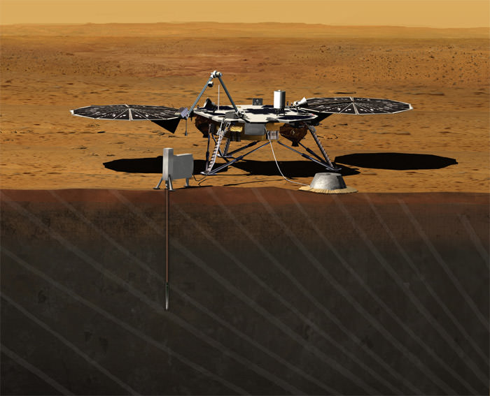
Artist rendition of NASA’s Mars InSight (Interior exploration using Seismic Investigations, Geodesy and Heat Transport) Lander, which was selected as part of the Discovery Programs 2010 call for submissions and will be launched by 2016. Credit: JPL/NASA
These finalists will receive $3 million in federal grants for detailed concept studies, and the mission (or missions) that are ultimately chosen will be launched by December 31st, 2021. The Discovery Program began back in 1992, and launched its first mission- the Mars Pathfinder – in 1996. Other Discovery missions include the NEAR Shoemaker probe that first orbited an asteroid, and the Stardust-NExT project, which returned samples of comet and interstellar dust to Earth.
NASA’s MESSENGER spacecraft, the planet-hunting Kepler telescope, and the Dawn spacecraft were also developed and launched under the Discovery program. The winning proposal of the Discovery Program’s 12th mission, which was issued back in 2010, was the InSight Mars lander. Set to launch in March of 2016, the lander will touch down on the red planet, deploy instruments to the planet’s interior, and measure its seismic activity.
NASA hopes to infuse the next mission with new technologies, offering up government-furnished equipment with incentives to sweeten the deal for each proposal. These include a supply of deep space optical communications system that are intended to test new high-speed data links with Earth. Science teams that choose to incorporate the laser telecom unit will be entitled to an extra $30 million above their $450 million cost cap.
If science teams wish to send entry probes into the atmospheres of Venus or Saturn, they will need a new type of heat shield. Hence, NASA’s solicitation includes a provision to furnish a newly-developed 3D-woven heat shield with a $10 million incentive. A deep space atomic clock is also available with a $5 million bonus, and NASA has offered to provide xenon ion thrusters and radioisotope heater units without incentives.
As with previous Discovery missions, NASA has stipulated that the mission must use solar power, limiting mission possibilities beyond Jupiter and Saturn. Other technologies may include the NEXT ion thruster and/or re-entry technology.
Have you heard the big news? NASA has reported that Mark Whatney is alive and well on the surface of Mars. No, wait, they’ve reported that there’s water on Mars. Didn’t they already report this? Today we’ll update you on the latest discovery and what this means for the search for life on Mars.