Carnival of Space #357

Carnival of Space. Image by Jason Major.

Welcome, come in to the 357th Carnival of Space! The carnival is a community of space science and astronomy writers and bloggers, who submit their best work each week for your benefit. I’m Susie Murph, part of the team at Universe Today and now, on to this week’s stories!

We’re going to start off with a double blast from the past, courtesy of CosmoQuest! This week, they’re featuring Stuart Robbins’s blog post from January 13, 2012, titled “Perspective on the Apollo 15 Landing Site.” He explores the region of the Moon that is the current home of the MoonMappers images that YOU are still mapping and exploring today – the Apollo 15 landing site area. It’s a neat place and we can study a lot of things there. Due to a quirk of optics and angles, you can even imagine you’re flying towards it.

Next, we stay with Cosmoquest’s Moon Mappers as they highlight the interesting discovery that the groundbreaking Soviet Lunakhod 2 lunar rover traveled farther than earlier estimated on it’s mission in 1972. Visit MoonMappers at Cosmoquest for more great stories!

Moving through history, we travel over to io9’s Space blog for a history of the American Space Shuttle disasters is a grim reminder of the danger of space travel. Just released is Major Malfunction, a documentary on the two Shuttle catastrophes. Major malfunction is an understatement for the destruction of Space Shuttle Challenger moments after launch in 1986, and the loss of Space Shuttle Columbia during re-entry in 2003.

Next at io9, we visit Mars to view the magnificent Draa, which are ancient landforms created from waves of sand. Check out the article and it’s images here.

We also have another article from io9, which new astronaut Reid Wiseman recounts his first adventurous days in space.

Now we’ll jump over for some gorgeous views from the Chandra X-Ray Observatory! One of their new images is a glorious view of the Whirlpool spiral galaxy which radiates with fantastic points of x-ray light. These image is breath-taking!

Want more gorgeous images? Visit Brownspaceman.com to see his discussion of the Tulip Nebula, which is a composite image which also maps the emissions from this incredible nebula.

Next, we head over to the Meridani Journalfor coverage of a major find in the search for exoplanets. A new world which is more than twice as large as Earth and about 17 times heavier has been discovered, a sort of “mega-Earth” as some have referred to it.

The NextBigFuture Blog lives up to it’s name by bringing us two interesting stories from Elon Musk and his company SpaceX. First, he points out that the key is reusability. Musk said the crewed Dragon is designed to land softly back on Earth and be rapidly turned around for another flight — possibly on the same day. Spacex is aiming for 10 flights without any significant refurbishment for the Dragon v2. The thing that will have to be refurbished is the main heat shield. Further improved heat shield materials [later versions of PICA-X] would mean Spacex could aim for 100 reusable flights.

We then head over to the Urban Astronomer, where recent observations of a very near pair of brown dwarf objects has led to something new: We’re watching the weather on stars themselves!

Finally, we return to Universe Today for some interesting potential missions. First, the B612 Foundation’s privately-funded Sentinel mission, once launched and placed in orbit around the Sun in 2018, will hunt for near-Earth asteroids down to about 140 meters in size using the most advanced infrared imaging technology, without government red tape to hamper the mission. Next, the NASA Innovative Advanced Concepts office announced a dozen far-flung drawing-board proposals that have received $100,000 in Phase 1 funding for the next 9-12 months, one of which is a balloon for exploring Titan. We’re looking forward to hearing about these projects and many others in the coming years.

That’s it for this week’s Carnival! See you all next time!

And if you’re interested in looking back, here’s an archive to all the past Carnivals of Space. If you’ve got a space-related blog, you should really join the carnival. Just email an entry to [email protected], and the next host will link to it. It will help get awareness out there about your writing, help you meet others in the space community – and community is what blogging is all about. And if you really want to help out, sign up to be a host. Send an email to the above address.

Curiosity Captures Stunning New Mount Sharp Panorama ‘On The Go’

Curiosity rover panorama of Mount Sharp captured on June 6, 2014 (Sol 651) during traverse inside Gale Crater. Note rover wheel tracks at left. She will eventually ascend the mountain at the ‘Murray Buttes’ at right later this year. Assembled from Mastcam color camera raw images and stitched by Marco Di Lorenzo and Ken Kremer. Credit: NASA/JPL/MSSS/Marco Di Lorenzo/Ken Kremer-kenkremer.com

Curiosity rover panorama of Mount Sharp captured on June 6, 2014 (Sol 651) during traverse inside Gale Crater. Note rover wheel tracks at left. She will eventually ascend the mountain at the ‘Murray Buttes’ at right later this year. Assembled from Mastcam color camera raw images and stitched by Marco Di Lorenzo and Ken Kremer. Credit: NASA/JPL/MSSS/Marco Di Lorenzo/Ken Kremer-kenkremer.com
Story updated[/caption]

Within the past Martian day on Friday, June 6, NASA’s rover Curiosity captured a stunning new panorama of towering Mount Sharp and the treacherous sand dunes below which she must safely traverse before reaching the mountains foothills – while ‘On The Go’ to her primary destination.

See our brand new Mount Sharp photo mosaic above – taken coincidentally by humanity’s emissary on Mars on the 70th anniversary of D-Day on Earth.

Basically she’s eating desiccated dirt while running a Martian marathon.

Having said ‘Goodbye Kimberley’ after drilling her third bore hole deep into a cold red slab of enticing bumpy textures of Martian sandstone in the name of science, our intrepid mega rover Curiosity is trundling along with all deliberate speed towards the inviting slopes of sedimentary rocks at the base of mysterious Mount Sharp which hold clues to the habitability of the Red Planet.

The sedimentary layers of Mount Sharp, which reaches 3.4 miles (5.5 km) into the Martian sky, is the six wheeled robots ultimate destination inside Gale Crater because it holds caches of water altered minerals.

Such minerals could possibly mark locations that sustained potential Martian microbial life forms, past or present, if they ever existed.

Mars was far wetter and warmer – and more conducive to the origin of life – billions of years ago.

Curiosity’s panoramic view departing Mount Remarkable and ‘The Kimberley Waypoint’ where rover conducted 3rd drilling campaign inside Gale Crater on Mars. The navcam raw images were taken on Sol 630, May 15, 2014, stitched and colorized. Credit: NASA/JPL-Caltech/Ken Kremer – kenkremer.com/Marco Di Lorenzo

The 1 ton robot is driving on a path towards the Murray Buttes which lies across the dunes on the right side of Mount Sharp as seen in our photo mosaic above, with wheel tracks on the left side.

She will eventually ascend the mountain at the ‘Murray Buttes’ after crossing the sand dunes.

Curiosity still has roughly another 4 kilometers of driving to go to reach the foothills of Mount Sharp sometime later this year.

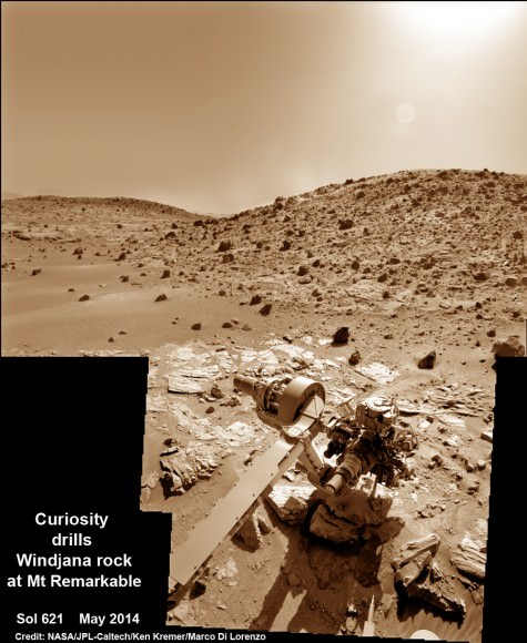
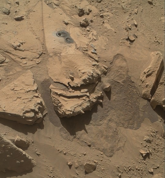
Approximately four weeks ago, Curiosity successfully completed her 3rd drilling campaign since landing at the science waypoint region called “The Kimberley” on May 5, Sol 621, into the ‘Windjana’ rock target at the base of a 16 foot tall ( 5 Meter) hill called Mount Remarkable.

Composite photo mosaic shows deployment of NASA Curiosity rovers robotic arm and two holes after drilling into ‘Windjana’ sandstone rock on May 5, 2014, Sol 621, at Mount Remarkable as missions third drill target for sample analysis by rover’s chemistry labs.  The navcam raw images were stitched together from several Martian days up to Sol 621, May 5, 2014 and colorized.   Credit: NASA/JPL-Caltech/Ken Kremer - kenkremer.com/Marco Di Lorenzo
Composite photo mosaic shows deployment of NASA Curiosity rovers robotic arm and two holes after drilling into ‘Windjana’ sandstone rock on May 5, 2014, Sol 621, at Mount Remarkable as missions third drill target for sample analysis by rover’s chemistry labs. The navcam raw images were stitched together from several Martian days up to Sol 621, May 5, 2014 and colorized. Credit: NASA/JPL-Caltech/Ken Kremer – kenkremer.com/Marco Di Lorenzo

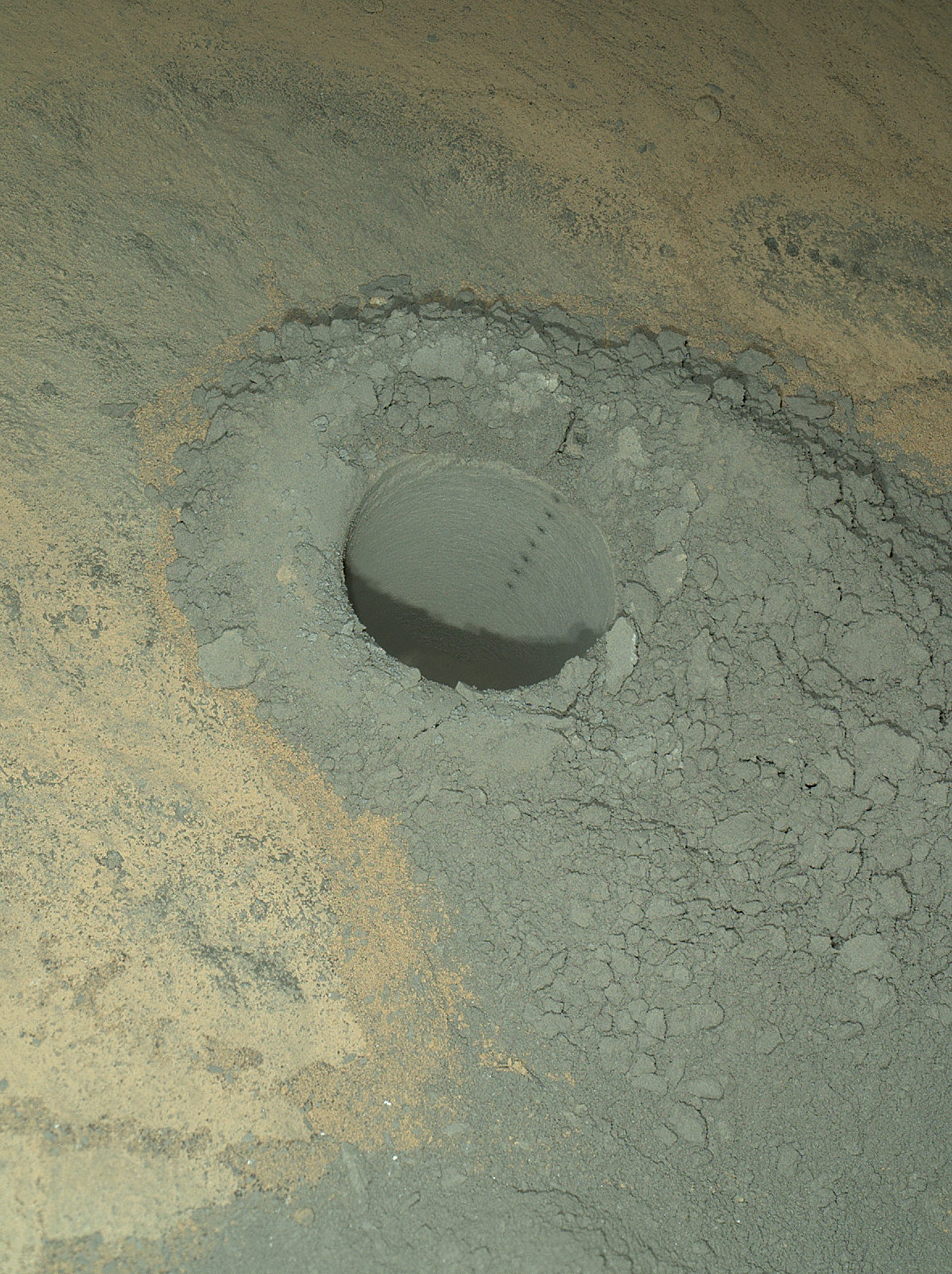
The fresh hole drilled into “Windjana” was 0.63 inch (1.6 centimeters) in diameter and about 2.6 inches (6.5 centimeters) deep and resulted in a mound of dark grey colored drill tailings piled around. It looked different from the initial holes drilled at Yellowknife Bay in the spring of 2013.

Windjana lies some 2.5 miles (4 kilometers) southwest of Yellowknife Bay.

Curiosity then successfully delivered pulverized and sieved samples to the pair of onboard miniaturized chemistry labs; the Chemistry and Mineralogy instrument (CheMin) and the Sample Analysis at Mars instrument (SAM) – for chemical and compositional analysis.

Before departing, Curiosity blasted the hole multiple times with her million watt laser on the Mast mounted Chemistry and Camera (ChemCam) instrument , leaving no doubt of her capabilities or intentions.

And she completed an up close examination of the texture and composition of ‘Windjana’ with the MAHLI camera and spectrometers at the end of her 7-foot-long (2 meter) arm to glean every last drop of science before moving on.

“Windjana” is named after a gorge in Western Australia.

While ‘On the Go’ to Mount Sharp, the rover is keeping busy with science activities by investigating the newly cored Martian material.

“Inside Curiosity we continue to analyse the Kimberley samples with CheMin and SAM,” wrote mission team member John Bridges in an update.

To date, Curiosity’s odometer totals 3.8 miles (6.1 kilometers) since landing inside Gale Crater on Mars in August 2012. She has taken over 154,000 images.

Stay tuned here for Ken’s continuing Curiosity, Opportunity, Orion, SpaceX, Boeing, Orbital Sciences, commercial space, MAVEN, MOM, Mars and more planetary and human spaceflight news.

Ken Kremer

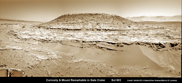
Curiosity’s Panoramic view of Mount Remarkable at ‘The Kimberley Waypoint’ where rover conducted 3rd drilling campaign inside Gale Crater on Mars. The navcam raw images were taken on Sol 603, April 17, 2014, stitched and colorized. Credit: NASA/JPL-Caltech/Ken Kremer – kenkremer.com/Marco Di Lorenzo.  Featured on APOD - Astronomy Picture of the Day on May 7, 2014
Curiosity’s Panoramic view of Mount Remarkable at ‘The Kimberley Waypoint’ where rover conducted 3rd drilling campaign inside Gale Crater on Mars. The navcam raw images were taken on Sol 603, April 17, 2014, stitched and colorized. Credit: NASA/JPL-Caltech/Ken Kremer – kenkremer.com/Marco Di Lorenzo
Featured on APOD – Astronomy Picture of the Day on May 7, 2014
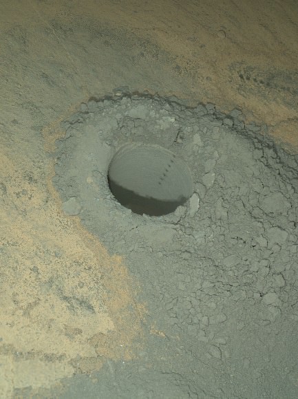
The Mars Hand Lens Imager on NASA's Curiosity Mars rover provided this nighttime view of a hole produced by the rover's drill and, inside the hole, a line of scars produced by the rover's rock-zapping laser. The hole is 0.63 inch (1.6 centimeters) in diameter.  The camera used its own white-light LEDs to illuminate the scene on May 13, 2014.  Credit:  NASA/JPL-Caltech/MSSS
The Mars Hand Lens Imager on NASA’s Curiosity Mars rover provided this nighttime view of a hole produced by the rover’s drill and, inside the hole, a line of scars produced by the rover’s rock-zapping laser. The hole is 0.63 inch (1.6 centimeters) in diameter. The camera used its own white-light LEDs to illuminate the scene on May 13, 2014. Credit: NASA/JPL-Caltech/MSSS

Detailed Deconstruction of the “Face” and Pyramids on Mars Claims

The 'face' on Mars, a popular landform in Cydonia Region on Mars. Credit: NASA/JPL/University of Arizona.

Intrigued by the thought of alien artifacts on Mars, with structures like a Martian-built statue of a giant face surrounded by pyramids or even cities? Better check the math on that. Better yet, Stuart Robbins has already checked that math and BOOM! it doesn’t check out.

So called “Mars anomalists” like Richard Hoagland have already been debunked mightily by folks like Phil Plait, but Robbins — who hosts the “Exposing Pseudo Astronomy” podcast — takes it to a whole new level. He’s just put out a video version of his podcast about claims about the Cydonia region on Mars, some of the math behind it, an exploration of the “null hypothesis” (what the results would be if it were purely random), and draws conclusions based on the latest orbital imagery of Mars.

Hoagland and others claim some of the features in Cydonia display special geometry and numbers that are encoded within them. And, the only way those numbers and that geometry could be there is if it was created by some sort of intelligence, i.e aliens. Robbins provides detailed explanations of the mathematical simulations and the arguments against these claims.

“What the Mars anomalists do is a really good example of cherry picking/the Texas Sharpshooter fallacy,” Robbins told Universe Today. He concludes the video by basically saying, “Hey! Space exploration is still awesome and cool, and you really don’t NEED the pseudoscience to make it amazing and rewarding.”

Watch above, and check out Robbins’ excellent podcast.

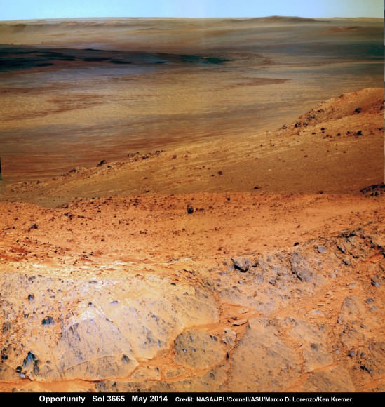
Opportunity Overlooks Ridge for Spectacular Vista of Vast Martian Crater and Habitable Zone Ahead

NASA’s Opportunity Mars rover captures sweeping panoramic vista near the ridgeline of 22 km (14 mi) wide Endeavour Crater’s western rim. The center is southeastward and also clearly shows the distant rim. See the complete panorama below. This navcam panorama was stitched from images taken on May 10, 2014 (Sol 3659) and colorized. Credit: NASA/JPL/Cornell/Marco Di Lorenzo/Ken Kremer-kenkremer.com

NASA’s Opportunity Mars rover captures sweeping panoramic vista near the ridgeline of 22 km (14 mi) wide Endeavour Crater’s western rim. The center is southeastward and also clearly shows the distant rim. See the complete panorama below. This navcam panorama was stitched from images taken on May 10, 2014 (Sol 3659) and colorized. Credit: NASA/JPL/Cornell/Marco Di Lorenzo/Ken Kremer-kenkremer.com
More mosaics and 10 year route map below[/caption]

NASA’s incredibly long lived Opportunity rover has driven to the ridgeline of a Martian mountain and captured spectacular panoramic vistas peering down into the vast expanse of huge Endeavour crater and out along the jagged rim segments leading to her next target – which scientists believe holds minerals indicative of a habitable zone. See mosaic views above and below.

Since departing the world famous ‘Jelly Doughnut’ rock by the summit of ‘Solander Point’ in February, Opportunity has spent the past several months driving south and exploring intriguing rock outcrops on ‘Murray Ridge’ located along the eroded western rim of Endeavour Crater.

The renowned robot is now exploring a region of outcrops atop the rims ridge that’s a possible site harboring deposits of hydrated clay minerals, formed in the ancient past when Mars was warmer and wetter.

The ten year old Red Planet rover first reached the rim of Endeavour Crater in August 2011. She has captured numerous sweeping gorgeous vistas during her first of its kind expedition on the surface of another planet by an alien probe from Earth.

Read my earlier story detailing the top 10 discoveries from twin sisters Spirit and Opportunity according to Deputy Principal Investigator Prof. Ray Arvidson – here.

The gigantic crater spans 14 miles (22 kilometers) in diameter.

So there is endless enthralling terrain to investigate – for at least another 10 years!

The floor of Endeavour crater is filled with dark sand, brighter dust, and, in the distance, dusty haze, says NASA.

This vista of the Endeavour Crater rim was acquired by NASA's Mars Exploration Rover Opportunity's panoramic camera on April 18, 2014, from the southern end of "Murray Ridge" on the western rim of the crater. In mid-May, the rover approached the dark outcrops on the flank of the hill at right. The high peak in the distance on the right is informally named "Cape Tribulation" and is about 1.2 miles (2 kilometers) to the south of Opportunity's position when this view was recorded Credit: NASA/JPL-Caltech/Cornell Univ./Arizona State Univ.
This vista of the Endeavour Crater rim was acquired by NASA’s Mars Exploration Rover Opportunity’s panoramic camera on April 18, 2014, from the southern end of “Murray Ridge” on the western rim of the crater. In mid-May, the rover approached the dark outcrops on the flank of the hill at right. The high peak in the distance on the right is informally named “Cape Tribulation” and is about 1.2 miles (2 kilometers) to the south of Opportunity’s position when this view was recorded Credit: NASA/JPL-Caltech/Cornell Univ./Arizona State Univ.

Opportunity’s goal all the while has been to doggedly trek southwards towards exposures of aluminum-rich clays detected from orbit by NASA’s powerful Martian ‘Spysat’ – the Mars Reconnaissance Orbiter (MRO) – while gathering context data at rock outcrops at Murray Ridge along the winding way.

These aluminum-rich clay minerals, or phyllosilicates, likely formed billions of years ago in flowing liquid neutral water which is more conducive to life, compared to more acidic environments explored earlier in the mission, and is therefore potentially indicative of a Martian habitable zone and a scientific goldmine.

The science and engineering team has used the high resolution MRO spectral and imaging data to more efficiently direct Opportunity southwards along the Endeavour crater rim and towards the biggest caches of the clay minerals – which were detected at a mountainous rim segment called ‘Cape Tribulation’ and which is seen in the panoramic vistas.

Although Cape Tribulation still lies some 1.2 miles (2 kilometers) further south, the rover has just arrived at a region which the team believes shows the first signatures of the clay minerals.

NASA’s Opportunity Mars rover captures sweeping panoramic vista near the ridgeline of 22 km (14 mi) wide Endeavour Crater's western rim. The center is southeastward and the distant rim is visible in the center. An outcrop area targeted for the rover to study is at right of ridge.  This navcam panoram was stitched from images taken on May 10, 2014 (Sol 3659) and colorized.  Credit: NASA/JPL/Cornell/Marco Di Lorenzo/Ken Kremer-kenkremer.com
NASA’s Opportunity Mars rover captures sweeping panoramic vista near the ridgeline of 22 km (14 mi) wide Endeavour Crater’s western rim. The center is southeastward and the distant rim is visible in the center. An outcrop area targeted for the rover to study is at right of ridge. This navcam panorama was stitched from images taken on May 10, 2014 (Sol 3659) and colorized. Credit: NASA/JPL/Cornell/Marco Di Lorenzo/Ken Kremer-kenkremer.com

“The rover is exploring the region of aluminum-hydroxyl clay minerals seen from orbit,” said NASA in a mission update.

The six wheeled robot will utilize her mast mounted cameras and arm mounted microscopic imager (MI) and APXS spectrometer to gather images and measurements to unlock the mysteries of Mars ability to support life – past or present.

“The more we explore Mars, the more interesting it becomes. These latest findings present yet another kind of gift that just happens to coincide with Opportunity’s 10th anniversary on Mars,” said Michael Meyer, lead scientist for NASA’s Mars Exploration Program.

“We’re finding more places where Mars reveals a warmer and wetter planet in its history. This gives us greater incentive to continue seeking evidence of past life on Mars.”

Opportunity Mars rover peers over mountain ridge for gorgeous vista into floor and out to distant rim of 22 km (14 mi) wide Endeavour Crater.  This pancam camera view was assembled from images taken on May 16, 2014 (Sol 3665) with false color sky.  Credit: NASA/JPL/Cornell/Marco Di Lorenzo/Ken Kremer-kenkremer.com
Opportunity Mars rover peers over mountain ridge for gorgeous vista into floor and out to distant rim of 22 km (14 mi) wide Endeavour Crater. This pancam camera view was assembled from images taken on May 16, 2014 (Sol 3665) with false color sky. Credit: NASA/JPL/Cornell/Marco Di Lorenzo/Ken Kremer-kenkremer.com

And Opportunity is now power-rich following a series of fortuitous wind cleaning events that substantially cleared the dust off the power generating solar wing arrays.

The solar array energy production has reached 761 watt-hours compared to about 900 watt-hours at landing in 2004 and only about 270 watt-hours just before Christmastime in December 2013.

“Solar panels [are] cleanest since about sol 1600 [September 2008],” says mission science team member Larry Crumpler.

More power means more work time and more bonus science studies and data return.

So the robot survived magnificently through her 6th harsh Martian winter with plenty of science rich targets planned ahead during the southern hemisphere Martian spring and summer.

Opportunity by Solander Point peak – 2nd Mars Decade Starts here!  NASA’s Opportunity rover captured this panoramic mosaic on Dec. 10, 2013 (Sol 3512) near the summit of “Solander Point” on the western rim of Endeavour Crater where she starts Decade 2 on the Red Planet. She is currently investigating outcrops of potential clay minerals formed in liquid water on her 1st mountain climbing adventure. Assembled from Sol 3512 navcam raw images. Credit: NASA/JPL/Cornell/Marco Di Lorenzo/Ken Kremer-kenkremer.com
Opportunity by Solander Point peak – 2nd Mars Decade Starts here!
NASA’s Opportunity rover captured this panoramic mosaic on Dec. 10, 2013 (Sol 3512) near the summit of “Solander Point” on the western rim of Endeavour Crater where she starts Decade 2 on the Red Planet. She is currently investigating outcrops of potential clay minerals formed in liquid water on her 1st mountain climbing adventure. Assembled from Sol 3512 navcam raw images. Credit: NASA/JPL/Cornell/Marco Di Lorenzo/Ken Kremer-kenkremer.com

Today, May 24, marks Opportunity’s 3673nd Sol or Martian Day roving Mars – compared to a warranty of just 90 Sols.

So far she has snapped over 192,600 amazing images on the first overland expedition across the Red Planet.

Her total odometry stands at over 24.49 miles (39.41 kilometers) since touchdown on Jan. 24, 2004 at Meridiani Planum.

Meanwhile on the opposite side of Mars, Opportunity’s younger sister rover Curiosity is trekking towards gigantic Mount Sharp and just drilled into her 3rd Red Planet rock at Kimberley.

Stay tuned here for Ken’s continuing Curiosity, Opportunity, Orion, SpaceX, Boeing, Orbital Sciences, MAVEN, MOM, Mars and more planetary and human spaceflight news.

Ken Kremer

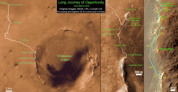
Traverse Map for NASA’s Opportunity rover from 2004 to 2014 - A Decade on Mars.  This map shows the entire path the rover has driven during a decade on Mars and over 3660 Sols, or Martian days, since landing inside Eagle Crater on Jan 24, 2004 to current location along Murray Ridge south of Solander Point summit at the western rim of Endeavour Crater and heading to clay minerals at Cape Tribulation.  Opportunity discovered clay minerals at Esperance - indicative of a habitable zone.  Credit: NASA/JPL/Cornell/ASU/Marco Di Lorenzo/Ken Kremer
Traverse Map for NASA’s Opportunity rover from 2004 to 2014 – A Decade on Mars
This map shows the entire path the rover has driven during a decade on Mars and over 3660 Sols, or Martian days, since landing inside Eagle Crater on Jan 24, 2004 to current location along Murray Ridge south of Solander Point summit at the western rim of Endeavour Crater and heading to clay minerals at Cape Tribulation. Opportunity discovered clay minerals at Esperance – indicative of a habitable zone. Credit: NASA/JPL/Cornell/ASU/Marco Di Lorenzo/Ken Kremer

Largest Crater Spotted on Mars Using Before-and-After Pictures

Image Credit: NASA/JPL-Caltech/MSSS

When it comes to the Universe, things often go bump in the night. But whether two galaxies collide, a star explodes in a brilliant supernova, or a meteor hits a massive planet, we tend to catch the aftermath tens to hundreds of thousands of years later.

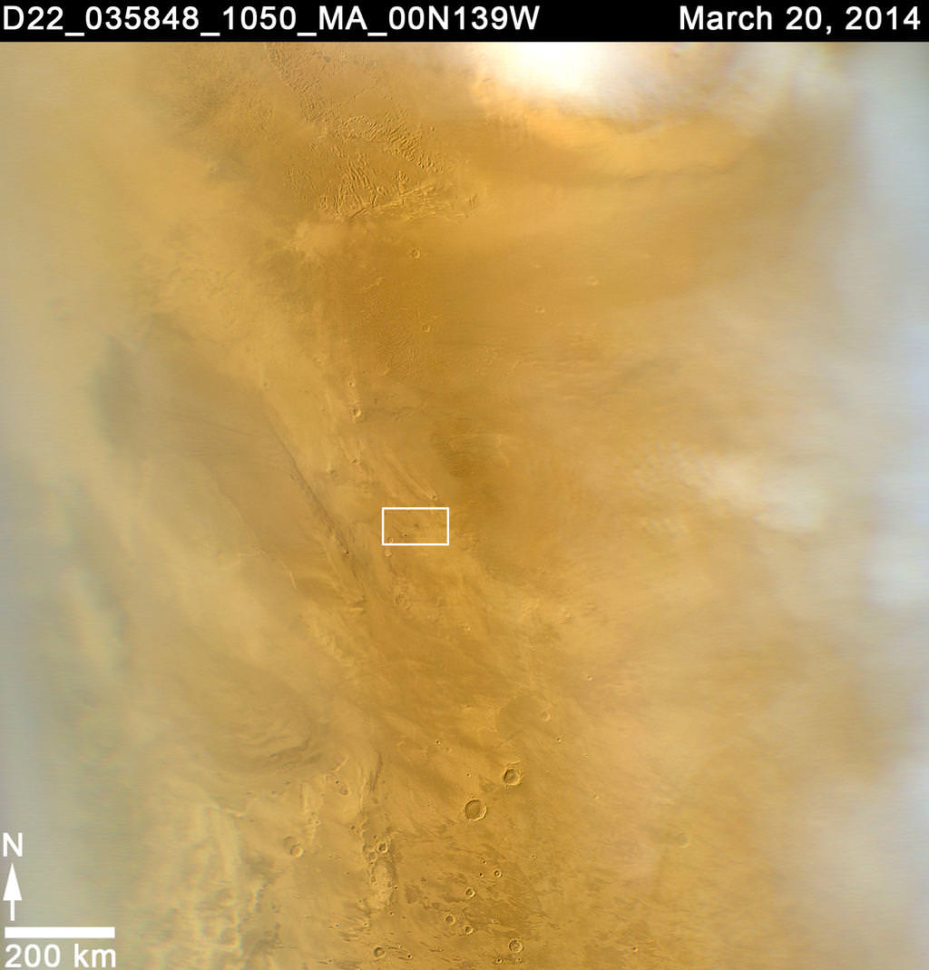
Of course, there’s always an exception to the rule. In today’s news, astronomers using NASA’s Mars Reconnaissance Orbiter have found a fresh meteor-impact crater. And it’s the biggest seen using before-and-after pictures.

When it comes to the red planet, we’ve seen evidence of fresh craters before, but usually the impact can’t be nailed down to better than a few years’ time. The constant sweep of the obiter’s weather-monitoring camera, the Mars Color Imager (MARCI), however, allowed us to pinpoint the impact to within a day.

The orbiter began its systematic observation of Mars in 2006. Ever since, Bruce Cantor, MARCI’s principle investigator, has examined the camera’s daily images, searching for evidence of dust storms and other observable weather events. Cantor’s findings help NASA operators plan for weather events that may be harmful to the solar-powered rover, Opportunity.

Nearly two months ago, Cantor noticed a black smudge — a telltale sign of an impact — on the red planet. “It wasn’t what I was looking for,” Cantor said in a NASA press release. “I was doing my usual weather monitoring and something caught my eye. It looked usual, with rays emanating from a central spot.”

So Cantor dug through earlier images, discovering that the dark spot wasn’t visible on March 27, 2012, but appeared on March 28, 2012.

MARCI is a low resolution camera, which is what allows it to see a large area of Mars constantly. But without a high resolution image, we can’t pick out the details of the impact-like black smudge. So Cantor performed follow-up observations with the orbiter’s telescope Context Camera (CTX) and the High Resolution Imaging Science Experiment (HiRISE).

CTX has imaged nearly the entire surface of Mars at least once during the orbiter’s seven-plus years of observations. It photographed the site of the newly-discovered crater in January 2012, revealing nothing prior to the impact. But two new craters appear in the recent image.

The largest crater is slightly elongated and spans 48.5 by 43.5 meters, roughly half the length of a football field. “The biggest crater is unusual, quite shallow compared to other fresh craters we have observed,” said HiRISE Principal Investigator Alfred McEwen of the University of Arizona, Tucson.

The impacting object is likely a few meters across. Something that small would burn up in the Earth’s atmosphere, but with a much thinner atmosphere (about 1% as thick as Earth’s), Mars lets most debris right on through.

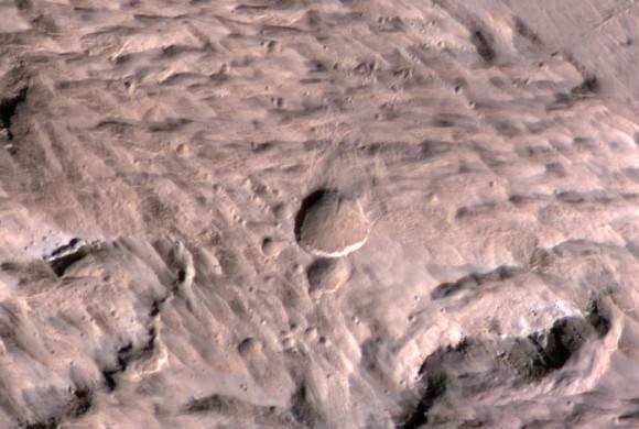
To add to the details, images from HiRISE revealed more than a dozen smaller craters near the two larger ones seen by CTX. It’s likely that Mars’ atmosphere, as thin as it is, supplied enough pressure to break the incoming meteoroid into smaller pieces, leaving multiple impacts behind.

Image Credit: NASA/JPL-Caltech/Univ. of Arizona
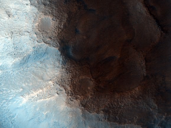
This image from the HiRISE camera, on board NASA’s Mars Reconnaissance Orbiter reveals the two impact craters and many smaller craters around them. Image Credit: NASA / JPL-Caltech / University of Arizona

“Studies of fresh impact craters on Mars yield valuable information about impact rates and about subsurface material exposed by the excavations,” said Leslie Tamppari, deputy project scientist for the Mars Reconnaissance Orbiter mission at NASA’s Jet Propulsion Laboratory. “The combination of HiRISE and CTX has found and examined many of them, and now MARCI’s daily coverage has given great precision about when a significant impact occurred.”

The initial NASA press release can be viewed here.

Curiosity says ‘Goodbye Kimberley’ after Parting Laser Blasts and Seeking New Adventures Ahead

The Mars Hand Lens Imager on NASA's Curiosity Mars rover provided this nighttime view of a hole produced by the rover's drill and, inside the hole, a line of scars produced by the rover's rock-zapping laser. The hole is 0.63 inch (1.6 centimeters) in diameter. The camera used its own white-light LEDs to illuminate the scene on May 13, 2014. Credit: NASA/JPL-Caltech/MSSS

NASA’s rover Curiosity said ‘Goodbye Kimberley’ having fulfilled her objectives of drilling into a cold red sandstone slab, sampling the tantalizing grey colored interior and pelting the fresh bore hole with a pinpoint series of parting laser blasts before seeking new adventures on the road ahead towards the inviting slopes of Mount Sharp, her ultimate destination.

Curiosity successfully drilled her 3rd hole deep into the ‘Windjama’ rock target at the base of Mount Remarkable and within the science waypoint at a region called “The Kimberley” on May 5, Sol 621.

Since then, the 1 ton robot carefully scrutinized the resulting 2.6 inches (6.5 centimeters) deep bore hole and the mound of dark grey colored drill tailings piled around for an up close examination of the texture and composition with the MAHLI camera and spectrometers at the end of her 7-foot-long (2 meters) arm to glean every last drop of science before moving on.

Curiosity’s panoramic view departing Mount Remarkable and ‘The Kimberley Waypoint’ where rover conducted 3rd drilling campaign inside Gale Crater on Mars. The navcam raw images were taken on Sol 630, May 15, 2014, stitched and colorized. Credit: NASA/JPL-Caltech/Ken Kremer – kenkremer.com/Marco Di Lorenzo

Multiple scars clearly visible inside the drill hole and on the Martian surface resulting from the million watt laser firings of the Mast mounted Chemistry and Camera (ChemCam) instrument left no doubt of Curiosity’s capabilities or intentions.

Furthermore she successfully delivered pulverized and sieved samples to the pair of onboard miniaturized chemistry labs; the Chemistry and Mineralogy instrument (CheMin) and the Sample Analysis at Mars instrument (SAM) – for chemical and compositional analysis.

Curiosity completed an “intensive investigation of ‘The Kimberley’, having successfully drilled, acquired and dropped samples into CheMin and SAM,” wrote science team member Ken Herkenhoff in an update.

“MAHLI has taken lots of excellent images of the drill hole, including some during the night with LEDs on, nicely showing the ChemCam LIBS spots.”

“The initial analysis of this new sample by Chemin is ongoing, requiring repeated overnight integration to build up high-quality data,” says Herkenhoff.

The rover’s earth bound handlers also decided that one drill campaign into Kimberley was enough.

So the rover will not be drilling into any other rock targets here.

Composite photo mosaic shows deployment of NASA Curiosity rovers robotic arm and two holes after drilling into ‘Windjana’ sandstone rock on May 5, 2014, Sol 621, at Mount Remarkable as missions third drill target for sample analysis by rover’s chemistry labs.  The navcam raw images were stitched together from several Martian days up to Sol 621, May 5, 2014 and colorized.   Credit: NASA/JPL-Caltech/Ken Kremer - kenkremer.com/Marco Di Lorenzo
Composite photo mosaic shows deployment of NASA Curiosity rovers robotic arm and two holes after drilling into ‘Windjana’ sandstone rock on May 5, 2014, Sol 621, at Mount Remarkable as missions third drill target for sample analysis by rover’s chemistry labs. The navcam raw images were stitched together from several Martian days up to Sol 621, May 5, 2014 and colorized. Credit: NASA/JPL-Caltech/Ken Kremer – kenkremer.com/Marco Di Lorenzo

And it may be a very long time before the next drilling since the guiding team of scientists and engineers wants desperately to get on and arrive at the foothills of Mount Sharp as soon as possible.

But the robot will undoubtedly be busy with further analysis of the ‘Windjana’ sample along the way, since there’s plenty of leftover sample material stored in the CHIMRA sample processing mechanism to allow future delivery of samples when the rover periodically pauses during driving.

This May 12, 2014, view from the Mars Hand Lens Imager (MAHLI) in NASA's Curiosity Mars Rover shows the rock target "Windjana" and its immediate surroundings after inspection of the site by the rover by drilling and other activities.  Credit:   NASA/JPL-Caltech/MSSS
This May 12, 2014, view from the Mars Hand Lens Imager (MAHLI) in NASA’s Curiosity Mars Rover shows the rock target “Windjana” and its immediate surroundings after inspection of the site by the rover by drilling and other activities. Credit: NASA/JPL-Caltech/MSSS

“Windjana” is named after a gorge in Western Australia.

It’s been a full year since the first two drill campaigns were conducted during 2013 at the ‘John Klein’ and ‘Cumberland’ outcrop targets inside Yellowknife Bay. They were both mudstone rock outcrops and the interiors were markedly different in color.

“The drill tailings from this rock are darker-toned and less red than we saw at the two previous drill sites,” said Jim Bell of Arizona State University, Tempe, deputy principal investigator for Curiosity’s Mast Camera (Mastcam).

“This suggests that the detailed chemical and mineral analysis that will be coming from Curiosity’s other instruments could reveal different materials than we’ve seen before. We can’t wait to find out!”

The science team chose Windjana for drilling “to analyze the cementing material that holds together sand-size grains in this sandstone,” says NASA.

Curiosity’s Panoramic view of Mount Remarkable at ‘The Kimberley Waypoint’ where rover conducted 3rd drilling campaign inside Gale Crater on Mars. The navcam raw images were taken on Sol 603, April 17, 2014, stitched and colorized. Credit: NASA/JPL-Caltech/Ken Kremer – kenkremer.com/Marco Di Lorenzo.  Featured on APOD - Astronomy Picture of the Day on May 7, 2014
Curiosity’s Panoramic view of Mount Remarkable at ‘The Kimberley Waypoint’ where rover conducted 3rd drilling campaign inside Gale Crater on Mars. The navcam raw images were taken on Sol 603, April 17, 2014, stitched and colorized. Credit: NASA/JPL-Caltech/Ken Kremer – kenkremer.com/Marco Di Lorenzo
Featured on APOD – Astronomy Picture of the Day on May 7, 2014

“The Kimberley Waypoint was selected because it has interesting, complex stratigraphy,” Curiosity Principal Investigator John Grotzinger, of the California Institute of Technology, Pasadena, told me.

Curiosity departed the ancient lakebed at the Yellowknife Bay region in July 2013 where she discovered a habitable zone with the key chemical elements and a chemical energy source that could have supported microbial life billions of years ago – and thereby accomplished the primary goal of the mission.

Windjama lies some 2.5 miles (4 kilometers) southwest of Yellowknife Bay.

Curiosity still has about another 4 kilometers to go to reach the foothills of Mount Sharp sometime later this year.

The sedimentary layers of Mount Sharp, which reaches 3.4 miles (5.5 km) into the Martian sky, is the six wheeled robots ultimate destination inside Gale Crater because it holds caches of water altered minerals. Such minerals could possibly indicate locations that sustained potential Martian life forms, past or present, if they ever existed.

Stay tuned here for Ken’s continuing Curiosity, Opportunity, Orion, SpaceX, Boeing, Orbital Sciences, LADEE, MAVEN, MOM, Mars and more planetary and human spaceflight news.

Ken Kremer

Phobos & Deimos — The Moons of Mars Explained

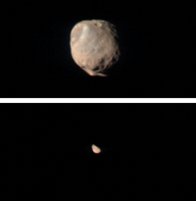
Where did Mars’ moons Phobos and Deimos come from? How did they end up in orbit around Mars? This cool video from the folks at Kurzgesagt answers the most-oft asked questions about these mini moons.

You should also check out their other wonderful videos, like the one about our own Moon, below, which explains how big our Moon really is. The answer might surprise you.

Continue reading “Phobos & Deimos — The Moons of Mars Explained”