NASA’s Outbound OSIRIS-Rex Asteroid Sampler Snaps ‘First-Light’ Images

On Sept. 19, 2016 the OCAMS MapCam camera recorded a star field in Taurus, north of the constellation Orion as part of the OSIRIS-REx spacecraft’s post-launch instrument check. Credits: NASA/Goddard/University of Arizona

NASA’s newest planetary probe, the OSIRIS-REx asteroid sampling spacecraft, is merrily snapping its ‘First-Light’ images following the successful power up and health check of all of the probes science instruments, barely three weeks after a stunning sunset launch from the Florida Space Coast – as it is outbound to asteroid Bennu.

“The spacecraft has passed its initial instrument check with flying colors as it speeds toward a 2018 rendezvous with the asteroid Bennu,” NASA officials reported in a mission update.

All five of the Origins, Spectral Interpretation, Resource Identification, Security-Regolith Explorer (OSIRIS-REx) spacecraft science instruments and one of its navigational instruments were powered on, starting last week on September 19.

NASA says they are all fully healthy for the groundbreaking mission whose purpose is to visit the carbon rich asteroid Bennu, snatch samples from the black as coal surface and return them to Earth in 2023 inside a Sample Return Capsule that will soft land by parachute in the Utah desert.

The seven year roundtrip mission to Bennu and back could potentially bring back samples infused with the organic chemicals like amino acids that are the building blocks of life as we know it.

“The data received from the checkout indicate that the spacecraft and its instruments are all healthy.”

The ‘First-Light’ image shown above was taken on Sept. 19, 2016 by the probes OCAMS MapCam camera and recorded a star field in Taurus, north of the constellation Orion along with Orion’s bright red star Betelgeuse.

“MapCam’s first color image is a composite of three of its four color filters, roughly corresponding to blue, green, and red wavelengths. The three images are processed to remove noise, co-registered, and enhanced to emphasize dimmer stars,” researchers said.

The OSIRIS-REx Camera Suite (OCAMS) was the first of the five science instrument to be tested and checlked out perfectly with “no issues.” It was provided by the University of Arizona and is comprised of three cameras which will image and map Bennu in high resolution.

View of science instrument suite and TAGSAM robotic sample return arm on NASA’s OSIRIS-REx asteroid sampling spacecraft inside the Payloads Hazardous Servicing Facility at NASA's Kennedy Space Center.  Probe is slated for Sep. 8, 2016 launch to asteroid Bennu from Cape Canaveral Air Force Station, FL.  Credit: Ken Kremer/kenkremer.com
View of science instrument suite and TAGSAM robotic sample return arm on NASA’s OSIRIS-REx asteroid sampling spacecraft inside the Payloads Hazardous Servicing Facility at NASA’s Kennedy Space Center. Probe is slated for Sep. 8, 2016 launch to asteroid Bennu from Cape Canaveral Air Force Station, FL. Credit: Ken Kremer/kenkremer.com

All the other instruments were also powered on and checked out flawlessly – including the OSIRIS-REx Laser Altimeter (OLA) which fired its laser, the OSIRIS-REx Visible and Infrared Spectrometer (OVIRS), the OSIRIS-REx Thermal Emissions Spectrometer (OTES), and the student designed Regolith X-ray Imaging Spectrometer (REXIS).

Lastly, the Touch and Go Camera System (TAGCAMS) navigational camera was successfully powered on and tested.

Furthermore, TAGCAMS took a dramatic image of the spacecraft’s Sample Return Capsule (below) – which is designed to bring at least a 60-gram (2.1-ounce) sample of Bennu’s surface soil and rocks back to Earth in 2023 for study by scientists using the world’s most advanced research instruments.

Image of OSIRIS-Rex Sample Return Capsule taken by StowCam instrument on Sept. 22, 2016, two weeks after launch, during initial science instrument checkout at a distance of 3.9 million miles (6.17 million km) away from Earth.  Credit: NASA
Image of OSIRIS-Rex Sample Return Capsule taken by StowCam instrument on Sept. 22, 2016, two weeks after launch, during initial science instrument checkout at a distance of 3.9 million miles (6.17 million km) away from Earth. Credit: NASA

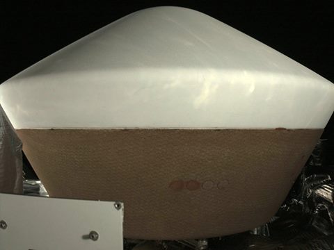
The capsule image was captured by the StowCam portion of TAGCAMS when it was 3.9 million miles (6.17 million km) away from Earth and traveling at a speed of 19 miles per second (30 km/s) around the Sun.

The StowCam image of the Sample Return Capsule shows it “is in perfect condition,” according to the science team.

Overhead view of NASA’s OSIRIS-REx asteroid sampling spacecraft with small white colored sample return canister atop,  inside the Payloads Hazardous Servicing Facility high bay at NASA's Kennedy Space Center. Launch is slated for Sep. 8, 2016 to asteroid Bennu from Cape Canaveral Air Force Station, FL.   Credit:  Julian Leek
Overhead view of NASA’s OSIRIS-REx asteroid sampling spacecraft with small white colored sample return canister atop, inside the Payloads Hazardous Servicing Facility high bay at NASA’s Kennedy Space Center. Launch is slated for Sep. 8, 2016 to asteroid Bennu from Cape Canaveral Air Force Station, FL. Credit: Julian Leek

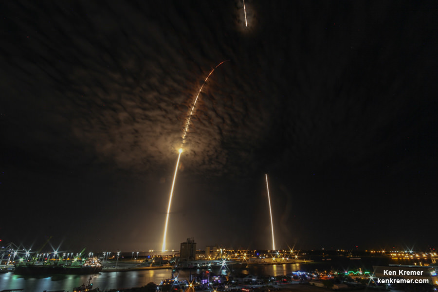
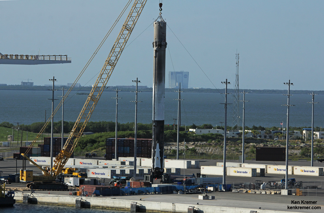
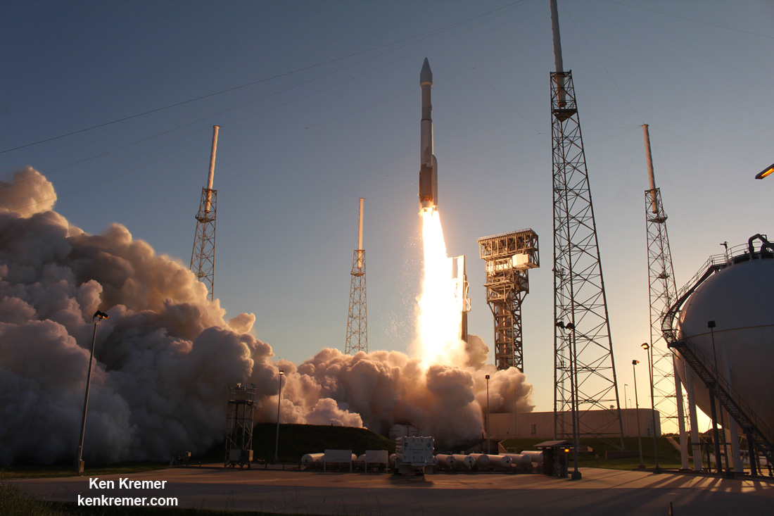
The OSIRIS-REx spacecraft departed Earth with an on time engine ignition of a United Launch Alliance Atlas V rocket under crystal clear skies on Thursday, September 8 at 7:05 p.m. EDT from Space Launch Complex 41 at Cape Canaveral Air Force Station.

The ULA Atlas V injected OSIRIS-Rex perfectly onto its desired trajectory.

“We got everything just exactly perfect,” said Dante Lauretta, the principal investigator for OSIRIS-REx at the University of Arizona, at the post launch briefing at the Kennedy Space Center. “We hit all our milestone within seconds of predicts.

United Launch Alliance Atlas V rocket lifts off from Space Launch Complex 41 at Cape Canaveral Air Force Station carrying NASA’s Origins, Spectral Interpretation, Resource Identification, Security-Regolith Explorer, or OSIRIS-REx spacecraft on the first U.S. mission to sample an asteroid, retrieve at least two ounces of surface material and return it to Earth for study.  Liftoff was at 7:05 p.m. EDT on September 8, 2016 in this remote camera view taken from inside the launch pad perimeter.  Note the newly install crew access arm and white room for astronaut flights atop Atlas starting in early 2018.   Credit: Ken Kremer/kenkremer.com
United Launch Alliance Atlas V rocket lifts off from Space Launch Complex 41 at Cape Canaveral Air Force Station carrying NASA’s Origins, Spectral Interpretation, Resource Identification, Security-Regolith Explorer, or OSIRIS-REx spacecraft on the first U.S. mission to sample an asteroid, retrieve at least two ounces of surface material and return it to Earth for study. Liftoff was at 7:05 p.m. EDT on September 8, 2016 in this remote camera view taken from inside the launch pad perimeter. Note the newly install crew access arm and white room for astronaut flights atop Atlas starting in early 2018. Credit: Ken Kremer/kenkremer.com

The space rock measures about the size of a small mountain at about a third of a mile in diameter.

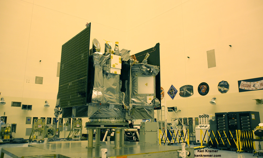
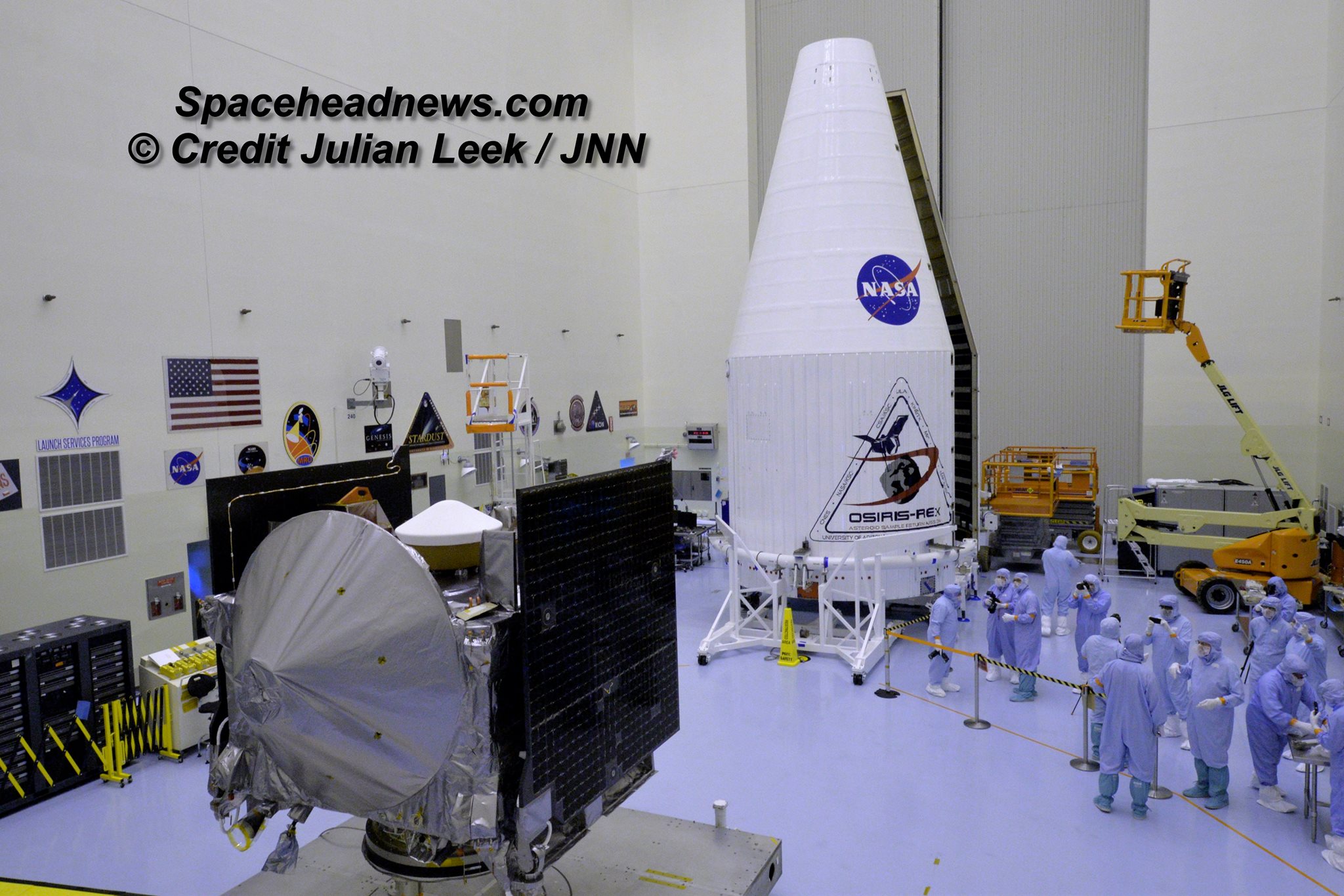
“The primary objective of the OSIRIS-Rex mission is to bring back pristine material from the surface of the carbonaceous asteroid Bennu, OSIRIS-Rex Principal Investigator Dante Lauretta told Universe Today in a prelaunch interview in the KSC cleanroom with the spacecraft as the probe was undergoing final preparations for shipment to the launch pad.

“We are interested in that material because it is a time capsule from the earliest stages of solar system formation.”

“It records the very first material that formed from the earliest stages of solar system formation. And we are really interested in the evolution of carbon during that phase. Particularly the key prebiotic molecules like amino acids, nucleic acids, phosphates and sugars that build up. These are basically the biomolecules for all of life.”

The asteroid is 1,614-foot (500 m) in diameter and crosses Earth’s orbit around the sun every six years.

After a two year flight through space, including an Earth swing by for a gravity assisted speed boost in 2017, OSIRIS-REx will reach Bennu in Fall 2018 to begin about 2 years of study in orbit to determine the physical and chemical properties of the asteroid in extremely high resolution.

Watch my up close launch video captured directly at the pad with the sights and sounds of the fury of blastoff:

Video Caption: ULA Atlas V rocket lifts off on September 8, 2016 from Space Launch Complex 41 at Cape Canaveral Air Force Station carrying NASA’s OSIRIS-REx asteroid sampling spacecraft, in this remote camera view taken from inside the launch pad perimeter. Credit: Ken Kremer/kenkremer.com

Watch for Ken’s continuing OSIRIS-REx mission reporting. He reported on the spacecraft and launch from on site at the Kennedy Space Center and Cape Canaveral Air Force Station, FL.

Stay tuned here for Ken’s continuing Earth and planetary science and human spaceflight news.

Ken Kremer

Where Can I Take Off My Space Helmet?

Where Can I Take Off My Space Helmet?

It’s been a while since I read the NASA manual on space helmet operation, but if I recall correctly, they really just have one major rule. When you go to space, keep your space helmet on.

I don’t care what haunting music those beguiling space sirens are playing. It doesn’t matter if you’ve got a serious case of space madness, and you’re hallucinating that you’re back on your Iowa farm, surrounded by your loved ones. Even if you just turned on an ancient terraforming machine and you’re stumbling around the surface of Mars like an idiot. You keep your helmet on.

Keep. Your. Helmet. On. Credit: NASA

Not convinced? Well then, allow me to explain what happens if you decide to break that rule. Without a helmet, and your own personal Earth-like atmosphere surrounding you, you’ll be exposed to the hard vacuum of space.

Within a moment, all the air will rush out of your lungs, and then you’ll fall unconscious in about 45 seconds. Starved for oxygen, you’ll die of suffocation in just a couple of minutes. Then you’ll freeze solid and float about forever. Just another meat asteroid in the Solar System.

That’s the official stance on space helmet operation, but just between you and me, there might be a little wiggle room. A few other places in the Solar System where you can take your helmet off for just a moment, and maybe not die instantaneously.

Earth is obviously safe. If you’re down here on the planet, and you’re still wearing your helmet, you’re missing the whole point of why you need a helmet in the first place. That space helmet rule only applies to space, silly, you can take it off down here.

In order to survive, the human body needs a few things. First, we need pressure surrounding our body, and helping to keep our lungs inflated. The Earth’s atmosphere provides that service, stacking a huge column of air down on top of you.

Without enough pressure, the air will blast out of your lungs and you’ll suffocate. Too much pressure and your lungs will crush and your heart will give out.

You’re going to want atmospheric pressure somewhere between .5 to 5 times the atmosphere of Earth.

If you can’t find air, then some other gas or even water will do in a pinch. You can’t breathe it, but it can provide the pressure you’re looking for.

Do not take your helmet off on the Moon. Credit: NASA

If you’ve got the pressure right, then your next priority will be the temperature. You know what it’s like to be too cold on Earth, and too hot, so use your judgement here. It’s too cold if you’re starting to die of hypothermia, and too hot if you’re above 60 C for a few minutes.

If you really want to thrive, find air you can breathe. Ideally a nice mixture of nitrogen and oxygen. Again, here on Earth, that column of air pushing down on you also allows you to breathe. If you swapped air for carbon dioxide or water, you’re going to need to hold your breath.

So what are some other places in the Solar System that you could take your helmet off for a few brief moments?

Your best bet is the planet Venus. Not down at the surface, where the temperature is hot enough to melt lead, and it’s 90 atmospheres pressure.

But up in the cloud tops, it’s a whole different story. At 52.5 kilometers altitude, the temperature is about 37 C. A little stifling, but not too bad. And the air pressure is about 65% Earth’s air pressure.

Credit: NASA
Hold your breath if you’re planning on taking off your helmet within the clouds of Venus. Credit: NASA

The problem is that this region is right in the middle of Venus’ sulphuric acid cloud layer, so you might inhale a mist of toxic acid if you tried to breathe. Not to mention the fact that Venus’ atmosphere is carbon dioxide, which means you’ll asphyxiate if you tried to breathe it.

But assuming you had some kind of air supply to breathe, and a suit to protect you from the sulphuric acid, you could hang around, without a helmet as long as you liked.

Take that! Overly draconian NASA helmet rules.

Out on the surface of Titan? Good news! The surface pressure on Titan is 1.45 times that of Earth. You won’t need a pressure helmet at all, ever. You will need a warming helmet, however, since the temperature on Titan is -179 C. You might be able to take that helmet off for a brief moment, before your face freezes, but don’t take a breath, otherwise you’ll freeze your lungs.

Want another location? No problem. Astronomers are pretty sure there are vast reservoirs of water under the surface of many moons and large objects in the Solar System, from Europa to Charon.

This artist's concept of Jupiter's moon Ganymede, the largest moon in the solar system, illustrates the club sandwich model of its interior oceans. Credit: NASA/JPL
This artist’s concept of Jupiter’s moon Ganymede, the largest moon in the solar system, illustrates the club sandwich model of its interior oceans. You could try taking your helmet off while diving in them. Credit: NASA/JPL

They’re heated up through tidal interactions, and could be dozens of kilometers thick. Drill down through the ice sheet, and then just dive into the icy waters without a helmet. It’ll be really cold, and you won’t be able to breathe, but you can stay alive as long as you can hold your breath.

Did you jump out of your spacecraft and now you’re falling to your death into one of the Solar System’s gas giants? That’s bad news and it won’t end well. However, there’s a tiny silver lining. As you fall through the atmosphere of Jupiter, for example, there’ll be a moment when the temperature and pressure roughly match what your body can handle.

Go ahead and take your helmet off and enjoy that sweet spot before you plunge into the swirling hydrogen gas. Once again, though, don’t breathe. Hold your breath, the moment will last longer before you go unconscious.

And listen, if you really really need to take off your helmet in the cold vacuum of space, you can do it. Make sure you completely exhale so you don’t wreck your lungs. Then you’ve got about 45 seconds before you go unconscious.

That’s enough time to jump across to an open airlock, or kick that nasty xenomorph holding onto your leg into deep space.

Even though the NASA space helmet manual has one rule – keep your helmet on – you can see there are a few times and places where you can bend those rules without instantly dying. Use your judgement.

I’d like to thank Mechadense for posting a comment on an earlier Guide to Space YouTube video, which became the inspiration for this episode. Thanks for doing the math Mechadense and bringing the science.

Apollo 11 Moonwalker Buzz Aldrin Talks to Universe Today about ‘Destination Mars’

Apollo 11 moonwalker Buzz Aldrin discusses the human ‘Journey to Mars with Universe Today at newly opened ‘Destination Mars’ holographic experience during media preview at the Kennedy Space Center visitor complex in Florida on Sept. 18, 2016. Credit: Ken Kremer/kenkremer.com
Apollo 11 moonwalker Buzz Aldrin discusses the human ‘Journey to Mars with Universe Today at newly opened ‘Destination Mars’ holographic experience during media preview at the Kennedy Space Center visitor complex in Florida on Sept. 18, 2016.  Credit: Ken Kremer/kenkremer.com
Apollo 11 moonwalker Buzz Aldrin discusses the human ‘Journey to Mars with Universe Today at newly opened ‘Destination Mars’ holographic experience during media preview at the Kennedy Space Center visitor complex in Florida on Sept. 18, 2016. Credit: Ken Kremer/kenkremer.com

KENNEDY SPACE CENTER VISITOR COMPLEX, FL – Sending humans on a ‘Journey to Mars’ and developing strategies and hardware to accomplish the daunting task of getting ‘Humans to Mars’ is NASA’s agency wide goal and the goal of many space enthusiasts – including Apollo 11 moonwalker Buzz Aldrin.

NASA is going full speed ahead developing the SLS Heavy lift rocket and Orion crew module with a maiden uncrewed launch from the Kennedy Space Center set for late 2018 to the Moon. Crewed Mars missions would follow by the 2030s.

In the marketplace of ideas, there are other competing and corollary proposals as well from government, companies and private citizens on pathways to the Red Planet. For example SpaceX CEO Elon Musk wants to establish a colony on Mars using an Interplanetary Transport System of SpaceX developed rockets and spaceships.

Last week I had the opportunity to ask Apollo 11 Moonwalker Buzz Aldrin for his thoughts about ‘Humans to Mars’ and the role of commercial space – following the Grand Opening ceremony for the new “Destination Mars’ holographic exhibit at the Kennedy Space Center visitor complex in Florida.

Moonwalker Aldrin strongly advocated for more commercial activity in space and that “exposure to microgravity” for “many commercial products” is good, he told Universe Today.

More commercial activities in space would aid space commerce and getting humans to Mars.

“We need to do that,” Aldrin told me.

Apollo 11 moonwalker Buzz Aldrin describes newly opened ‘Destination Mars’ holographic experience during media preview at the Kennedy Space Center visitor complex in Florida on Sept. 18, 2016.  Credit: Ken Kremer/kenkremer.com
Apollo 11 moonwalker Buzz Aldrin describes newly opened ‘Destination Mars’ holographic experience during media preview at the Kennedy Space Center visitor complex in Florida on Sept. 18, 2016. Credit: Ken Kremer/kenkremer.com

Buzz Aldrin is the second man to set foot on the Moon. He stepped onto the lunar soil a few minutes after Apollo 11 Commander Neil Armstrong, on July 20, 1969 in the Sea of Tranquility.

Aldrin also strongly supports some type of American space station capability “beyond the ISS” to foster the Mars capability.

And we need to be thinking about that follow on “US capability” right now!

“I think we need to have a US capability beyond the ISS to prepare for future activities right from the beginning,” Aldrin elaborated.

Currently the ISS partnership of the US, Russia, ESA, Japan and Canada has approved extending the operations of the International Space Station (ISS) until 2024. What comes after that is truly not known.

NASA is not planning for a follow-on space station in low Earth orbit at this time. The agency seems to prefer development of a commercial space station, perhaps with core modules from Bigelow Aerospace and/or other companies.

So that commercial space station will have to be designed, developed and launched by private companies. NASA and others would then lease space for research and other commercial activities and assorted endeavors on the commercial space station.

For example, Bigelow wants to dock their privately developed B330 habitable module at the ISS by 2020, following launch on a ULA Atlas V. And then spin it off as an independent space station when the ISS program ends – see my story.

Only China has firm plans for a national space station in the 2020’s. And the Chinese government has invited other nations to submit proposals. Russia’s ever changing space exploration plans may include a space station – but that remains to be actually funded and seen.

Regarding Mars, Aldrin has lectured widely and written books about his concept for “cycling pathways to occupy Mars,” he explained.

Watch this video of Apollo 11 moonwalker Buzz Aldrin speaking to Universe Today:

Video Caption: Buzz Aldrin at ‘Destination Mars’ Grand Opening at KSCVC. Apollo 11 moonwalker Buzz Aldrin talks to Universe Today/Ken Kremer during Q&A at ‘Destination Mars’ Holographic Exhibit Grand Opening ceremony at Kennedy Space Center Visitor Complex (KSCVC) in Florida on 9/18/16. Credit: Ken Kremer/kenkremer.com

Here is a transcript:

Universe Today/Ken Kremer: Can you talk about the role of commercial space [in getting humans to Mars]. Elon Musk wants to try and send people to Mars, maybe even before NASA. What do you think?

Buzz Aldrin: “Well, being a transportation guy in space for humans – well commercial, what that brings to mind is tourism plus space travel.

And there are many many more things commercial that are done with products that can be fine tuned by exposure to microgravity. And we need to do that.”

“I think we need to have a US capability beyond the ISS to prepare for future activities right from the beginning.”

“And that’s why what has sort of fallen into place is the name for my plan for the future – which is ‘cycling pathways to occupy Mars.’”

“A cycler in low Earth orbit, one in lunar orbit, and one to take people to Mars.”

“And they are utilized in evolutionary fashion.”

Apollo 11 moonwalker Buzz Aldrin during media preview of newly opened ‘Destination Mars’ holographic experience at the Kennedy Space Center visitor complex in Florida on Sept. 18, 2016.  Credit Julian Leek
Apollo 11 moonwalker Buzz Aldrin during media preview of newly opened ‘Destination Mars’ holographic experience at the Kennedy Space Center visitor complex in Florida on Sept. 18, 2016. Credit Julian Leek

Meanwhile, be sure to visit the absolutely spectacular “Destination Mars” holographic exhibit before it closes on New Year’s Day 2017 – because it is only showing at KSCVC.

A scene from ‘Destination Mars’ of Buzz Aldrin and  NASA’s Curiosity Mars rover with the Gale crater rim in the distance. The new, limited time interactive exhibit is now showing at the Kennedy Space Center visitor complex in Florida through Jan 1, 2017. Credit: NASA/JPL/Microsoft
A scene from ‘Destination Mars’ of Buzz Aldrin and NASA’s Curiosity Mars rover with the Gale crater rim in the distance. The new, limited time interactive exhibit is now showing at the Kennedy Space Center visitor complex in Florida through Jan 1, 2017. Credit: NASA/JPL/Microsoft

You can get more information or book a visit to Kennedy Space Center Visitor Complex, by clicking on the website link:

https://www.kennedyspacecenter.com/things-to-do/destination-mars.aspx

Stay tuned here for Ken’s continuing Earth and planetary science and human spaceflight news.

Ken Kremer

Apollo 11 moonwalker Buzz Aldrin discusses the human ‘Journey to Mars with Universe Today at newly opened ‘Destination Mars’ holographic experience during media preview at the Kennedy Space Center visitor complex in Florida on Sept. 18, 2016.  Credit: Ken Kremer/kenkremer.com
Apollo 11 moonwalker Buzz Aldrin discusses the human ‘Journey to Mars with Universe Today at newly opened ‘Destination Mars’ holographic experience during media preview at the Kennedy Space Center visitor complex in Florida on Sept. 18, 2016. Credit: Ken Kremer/kenkremer.com

Mercury Is Tectonically Active & Shrinking

New research suggests that Mercury is still contracting and shrinking. Credits: NASA/JHUAPL/Carnegie Institution of Washington/USGS/Arizona State University

Mercury is a fascinating planet. As our Suns’ closest orbiting body, it experiences extremes of heat and cold, has the most eccentric orbit of any Solar planet, and an orbital resonance that makes a single day last as long as two years. But since the arrival of the MESSENGER probe, we have learned some new and interesting things about the planet’s geological history as well.

For example, images that were recently obtained by the NASA spacecraft revealed previously undetected landforms – small fault scarps – that appear to be geologically young. The presence of these features have led scientists to conclude that Mercury is still contracting over time, which means that – like Earth – it is tectonically active.

In geology, fault scarps refer to small step-like formations in the surface of a planet, where one side of a fault has moved vertically relative to the other. Previously, scientists believed that Mercury was tectonically dead, and that all major geological activity had taken place in the planet’s early history.

Small graben, or narrow linear troughs, have been found associated with small fault scarps (lower white arrows) on Mercury, and on Earth’s moon. The small troughs, only tens of meters wide (inset box and upper white arrows), likely resulted from the bending of the crust as it was uplifted, and must be very young to survive continuous meteoroid bombardment. Credits: NASA/JHUAPL/Carnegie Institution of Washington/Smithsonian Institution
Images showing small fault scarps and trough (lower and upper white arrows) found on Mercury;s surface. Credits: NASA/JHUAPL/Carnegie Institution of Washington/Smithsonian Institution

This was evidenced by features spotted by the MESSENGER and Mariner 10 probes, both of which found evidence of large wrinkle ridges and fault scarps on the surface. The features were reasoned to be the result of Mercury contacting as it cooled early in its history (i.e. billion of years ago).

This action caused the planet’s crust to break, forming cliffs up to a kilometer and a half (about 1 mile) in height and hundreds of kilometers long. However, as the MESSENGER team noted, these small scarps were considerably younger, dating to about 50 million years of age.

They concluded that the scarps would have to be this young in order to survive bombardment by comets and meteoroids, a common occurrence on Mercury. They also noted their resemblance to similar features on the Moon, which also has young scarps that are the result of recent contraction.

The team’s findings were reported in a paper titled “Recent Tectonic Activity on Mercury Revealed by Small Thrust Fault Scarps“, which appeared in the October issue of Nature Geoscience.

The MESSENGER spacecraft has been in orbit around Mercury since March 2011. Image Credit: NASA/JHU APL/Carnegie Institution of Washington
The MESSENGER spacecraft has been in orbit around Mercury since March 2011. Credit: NASA/JHU APL/Carnegie Institution of Washington

As Tom Watters, the Smithsonian senior scientist at the National Air and Space Museum and the lead author of the paper, stated in a NASA press release:

“The young age of the small scarps means that Mercury joins Earth as a tectonically active planet, with new faults likely forming today as Mercury’s interior continues to cool and the planet contracts.”

The findings were made during the last 18 months of the MESSENGER mission, during which time the probe lowered its altitude to get higher-resolution images of the planet’s surface. The findings are also consistent with recent findings about Mercury’s global magnetic field, which appears to be powered by the planet’s slowly-cooling outer core.

As Jim Green, NASA’s Planetary Science Director, said of the discovery:

“This is why we explore. For years, scientists believed that Mercury’s tectonic activity was in the distant past. It’s exciting to consider that this small planet – not much larger than Earth’s moon – is active even today.”

All told, these findings have let scientists know that the planet is still alive, in the geological sense. It also means that that there is likely such as thing as Mercury-quakes, something which NASA is sure to follow up on if and when a lander mission (equipped with seismology instruments) is dispatched to the surface of the planet.

Further Reading: NASA, Nature Geoscience

Drilling at Unfathomable Alien Landscapes – All in a Sols (Day’s) Work for Curiosity

Dramatic wide angle mosaic view of butte with sandstone layers showing cross-bedding in the Murray Buttes region on lower Mount Sharp with distant view to rim of Gale crater, taken by Curiosity rover’s Mastcam high resolution cameras. This photo mosaic was assembled from Mastcam color camera raw images taken on Sol 1454, Sept. 8, 2016 and stitched by Ken Kremer and Marco Di Lorenzo, with added artificial sky. Featured at APOD on 5 Oct 2016. Credit: NASA/JPL/MSSS/Ken Kremer/kenkremer.com/Marco Di Lorenzo
Dramatic wide angle mosaic view of butte  with sandstone layers showing cross-bedding  in the Murray Buttes region on lower Mount Sharp with distant view to rim of Gale crater, taken by Curiosity rover’s Mastcam high resolution cameras.  This photo mosaic was assembled from Mastcam color camera raw images taken on Sol 1454, Sept. 8, 2016 and stitched by Ken Kremer and Marco Di Lorenzo, with added artificial sky.  Credit: NASA/JPL/MSSS/Ken Kremer/kenkremer.com/Marco Di Lorenzo
Dramatic wide angle mosaic view of butte with sandstone layers showing cross-bedding in the Murray Buttes region on lower Mount Sharp with distant view to rim of Gale crater, taken by Curiosity rover’s Mastcam high resolution cameras. This photo mosaic was assembled from Mastcam color camera raw images taken on Sol 1454, Sept. 8, 2016 and stitched by Ken Kremer and Marco Di Lorenzo, with added artificial sky. Credit: NASA/JPL/MSSS/Ken Kremer/kenkremer.com/Marco Di Lorenzo

Our beyond magnificent Curiosity rover has just finished her latest Red Planet drilling campaign – at the rock target called “Quela” – into the simply unfathomable alien landscapes she is currently exploring at the “Murray Buttes” region of lower Mount Sharp. And it’s all in a Sols (or Martian Day’s) work for our intrepid Curiosity!

“These images are literally out of this world.. I don’t think I have seen anything like them on Earth!” Jim Green, Planetary Sciences Director at NASA Headquarters, Washington, D.C., explained to Universe Today.

The “Murray Buttes” region is just chock full of the most stunning panoramic vistas that NASA’s Curiosity Mars Science Laboratory rover has come upon to date. Observe and enjoy them in our exclusive new photo mosaics above and below.

“We always try to find some sort of Earth analog but these make exploring another world all worth it!” Green gushed in glee.

They fill the latest incredible chapter in her thus far four year long quest to trek many miles (km) from the Bradbury landing site across the floor of Gale Crater to reach the base region of humongous Mount Sharp.

And these adventures are just a prelude to the even more glorious vistas she’ll investigate from now on – as she climbs higher and higher on an expedition to thoroughly examine the mountains sedimentary layers and unravel billions and billions of years of Mars geologic and climatic history.

Drilling holes into Mars during the Red Planet trek and carefully analyzing the pulverized samples with the rovers pair of miniaturized chemistry laboratories (SAM and CheMin) is the route to the answer of how and why Mars changed from a warmer and wetter planet in the ancient past to the cold, dry and desolate world we see today.

The rock target named “Quela” is located at the base of one of the buttes dubbed “Murray Butte number 12,” according to the latest mission update from Prof. John Bridges, a Curiosity rover science team member from the University of Leicester, England.

It took two tries to get the drilling done due to a technical issue, but all went well in the end and it was well worth the effort at a place never before explored by an emissary from Earth.

“The drill (successful at second attempt) is at Quela.”

The full depth drilling was completed on Sol 1464, Sept. 18, 2016 using the percussion drill at the terminus of the outstretched 7-foot-long (2-meter-long) robotic arm – as confirmed by imaging and further illustrated in our navcam camera photo mosaic.

And that immediately provided valuable insight into climate change on Mars.

“You can see how red and oxidised the tailings are, suggesting changing environmental conditions as we progress through the Mt. Sharp foothills,” Bridges explained in the mission update.

Curiosity bore holes measure approximately 0.63 inch (1.6 centimeters) in diameter and 2.6 inches (6.5 centimeters) deep.

Quela drill hole bored by Curiosity rover on Sol 1464, Sept. 18, 2016 as seen in this collage of Mastcam and MAHLI raw color images taken on Sol 1465. Image Credit: NASA/JPL/MSSS. Collage: Marco Di Lorenzo/Ken Kremer

To give you the context of the Murray Buttes region and the drilling at Quela, the image processing team of Ken Kremer and Marco Di Lorenzo has begun stitching together wide angle mosaic landscape views and up close views of the drilling using raw images from the variety of cameras at Curiosity’s disposal.

The next steps after boring into Quela were to “sieve the new sample, dump the unsieved fraction, and drop some of the sieved sample into CheMin,” says Ken Herkenhoff, Research Geologist at the USGS Astrogeology Science Center and an MSL science team member, in a mission update.

“But first, ChemCam will acquire passive spectra of the Quela drill tailings and use its laser to measure the chemistry of the wall of the new drill hole and of bedrock targets “Camaxilo” and “Okakarara.” Right Mastcam images of these targets are also planned.”

“After sunset, MAHLI will use its LEDs to take images of the drill hole from various angles and of the CheMin inlet to confirm that the sample was successfully delivered. Finally, the APXS will be placed over the drill tailings for an overnight integration.”

The rover had approached the butte from the south side several sols earlier to get in place, plan for the drilling, take imagery to document stratigraphy and make compositional observations with the ChemCam laser instrument.

Curiosity drills into Quela rock target in the Murray Buttes region on Sol 1464, Sept. 18, 2016, in this navcam camera mosaic, stitched from raw images and colorized.  Credit: NASA/JPL/Ken Kremer/kenkremer.com/Marco Di Lorenzo
Curiosity drills into Quela rock target in the Murray Buttes region on Sol 1464, Sept. 18, 2016, in this navcam camera mosaic, stitched from raw images and colorized. Credit: NASA/JPL/Ken Kremer/kenkremer.com/Marco Di Lorenzo

Sol after Sol the daily imagery transmitted back to eager researchers on Earth reveal spectacularly layered Martian rock formations in such exquisite detail that they look and feel just like America’s desert Southwest landscapes.

“These are the landforms that dominate the landscape at this point in the traverse – The Murray Buttes,” says Bridges.

Wide angle mosaic view shows spectacular buttes and layered sandstone in the Murray Buttes region on lower Mount Sharp from the Mastcam cameras on NASA's Curiosity Mars rover.  This photo mosaic was assembled from Mastcam color camera raw images taken on Sol 1455, Sept. 9, 2016 and stitched by Marco Di Lorenzo and Ken Kremer, with added artificial sky.  Credit: NASA/JPL/MSSS/Ken Kremer/kenkremer.com/Marco Di Lorenzo
Wide angle mosaic view shows spectacular buttes and layered sandstone in the Murray Buttes region on lower Mount Sharp from the Mastcam cameras on NASA’s Curiosity Mars rover. This photo mosaic was assembled from Mastcam color camera raw images taken on Sol 1455, Sept. 9, 2016 and stitched by Marco Di Lorenzo and Ken Kremer, with added artificial sky. Credit: NASA/JPL/MSSS/Ken Kremer/kenkremer.com/Marco Di Lorenzo

What are the Murray Buttes?

“These are formed by a cap of hard aeolian rock that has been partially eroded back, overlying the Murray mudstone.”

The imagery of the Murray Buttes and mesas show them to be eroded remnants of ancient sandstone that originated when winds deposited sand after lower Mount Sharp had formed.

Scanning around the Murray Buttes mosaics one sees finely layered rocks, sloping hillsides, the distant rim of Gale Crater barely visible through the dusty haze, dramatic hillside outcrops with sandstone layers exhibiting cross-bedding.

The presence of “cross-bedding” indicates that the sandstone was deposited by wind as migrating sand dunes, says the team.

Spectacular wide angle mosaic view showing sloping buttes and layered outcrops within the Murray Buttes region on lower Mount Sharp from the Mast Camera (Mastcam) on NASA's Curiosity Mars rover. This photo mosaic is stitched from Mastcam camera raw images taken on Sol 1454, Sept. 9, 2016 with added artificial sky.  Credit: NASA/JPL/MSSS/Ken Kremer/kenkremer.com/Marco Di Lorenzo
Spectacular wide angle mosaic view showing sloping buttes and layered outcrops within the Murray Buttes region on lower Mount Sharp from the Mast Camera (Mastcam) on NASA’s Curiosity Mars rover. This photo mosaic is stitched from Mastcam camera raw images taken on Sol 1454, Sept. 9, 2016 with added artificial sky. Credit: NASA/JPL/MSSS/Ken Kremer/kenkremer.com/Marco Di Lorenzo

Curiosity spent some six weeks or so traversing and exploring the Murray Buttes.

So after collecting all that great drilling data at Quela, the team is ready for even more spectacular new adventures!

“While the Murray Buttes were spectacular and interesting, it’s good to be back on the road again, as there is much more of Mt. Sharp to explore!” concludes Herkenhoff.

And the team is already commanding Curiosity to drive ahead in hot pursuit of the next drill target!

Dramatic hillside view showing sloping buttes and layered outcrops within of the Murray Buttes region on lower Mount Sharp from the Mast Camera (Mastcam) on NASA's Curiosity Mars rover. This photo mosaic is stitched and cropped from Mastcam camera raw images taken on Sol 1454, Sept. 8, 2016, with added artificial sky.  Credit: NASA/JPL/MSSS/Ken Kremer/kenkremer.com/Marco Di Lorenzo
Dramatic hillside view showing sloping buttes and layered outcrops within of the Murray Buttes region on lower Mount Sharp from the Mast Camera (Mastcam) on NASA’s Curiosity Mars rover. This photo mosaic is stitched and cropped from Mastcam camera raw images taken on Sol 1454, Sept. 8, 2016, with added artificial sky. Credit: NASA/JPL/MSSS/Ken Kremer/kenkremer.com/Marco Di Lorenzo

Ascending and diligently exploring the sedimentary lower layers of Mount Sharp, which towers 3.4 miles (5.5 kilometers) into the Martian sky, is the primary destination and goal of the rovers long term scientific expedition on the Red Planet.

Curiosity rover panorama of Mount Sharp captured on June 6, 2014 (Sol 651) during traverse inside Gale Crater.  Note rover wheel tracks at left.  She will eventually ascend the mountain at the ‘Murray Buttes’ at right later this year. Assembled from Mastcam color camera raw images and stitched by Marco Di Lorenzo and Ken Kremer.   Credit:   NASA/JPL/MSSS/Marco Di Lorenzo/Ken Kremer-kenkremer.com
Curiosity rover panorama of Mount Sharp captured on June 6, 2014 (Sol 651) during traverse inside Gale Crater. Note rover wheel tracks at left. She will eventually ascend the mountain at the ‘Murray Buttes’ at right later this year. Assembled from Mastcam color camera raw images and stitched by Marco Di Lorenzo and Ken Kremer. Credit: NASA/JPL/MSSS/Marco Di Lorenzo/Ken Kremer-kenkremer.com

Three years ago, the team informally named the Murray Buttes site to honor Caltech planetary scientist Bruce Murray (1931-2013), a former director of NASA’s Jet Propulsion Laboratory, Pasadena, California. JPL manages the Curiosity mission for NASA.

As of today, Sol 1470, September 24, 2016, Curiosity has driven over 7.9 miles (12.7 kilometers) since its August 2012 landing inside Gale Crater, and taken over 355,000 amazing images.

Stay tuned here for Ken’s continuing Earth and planetary science and human spaceflight news.

Ken Kremer

Wide angle mosaic shows lower region of Mount Sharp at center in between spectacular sloping hillsides  and layered rock outcrops of the Murray Buttes region in Gale Crater as imaged by the Mast Camera (Mastcam) on NASA's Curiosity Mars rover. This photo mosaic is stitched from Mastcam camera raw images taken on Sol 1451, Sept. 5, 2016 with added artificial sky.  Credit: NASA/JPL/MSSS/Ken Kremer/kenkremer.com/Marco Di Lorenzo
Wide angle mosaic shows lower region of Mount Sharp at center in between spectacular sloping hillsides and layered rock outcrops of the Murray Buttes region in Gale Crater as imaged by the Mast Camera (Mastcam) on NASA’s Curiosity Mars rover. This photo mosaic is stitched from Mastcam camera raw images taken on Sol 1451, Sept. 5, 2016 with added artificial sky. Credit: NASA/JPL/MSSS/Ken Kremer/kenkremer.com/Marco Di Lorenzo
Quela drill hole bored by Curiosity rover on Sol 1464, Sept. 18, 2016 as seen in this Matscam color image taken the same Sol. Credit: NASSA/JPL/MSSS
Quela drill hole bored by Curiosity rover on Sol 1464, Sept. 18, 2016 as seen in this MAHLI arm camera raw color image taken the same Sol. Credit: NASA/JPL/MSSS
Curiosity drills into Quela rock target on Sol 1464, Sept. 18, 2016 in this navcam camera mosaic.  Credit: NASA/JPL/Ken Kremer/kenkremer.com/Marco Di Lorenzo
Curiosity drills into Quela rock target on Sol 1464, Sept. 18, 2016 in this navcam camera mosaic. Credit: NASA/JPL/Ken Kremer/kenkremer.com/Marco Di Lorenzo

Approval For NASA Authorization Bill

NASA has unveiled a new exercise device that will be used by Orion crews to stay healthy on their mission to Mars. Credit: NASA

On Sept. 15th, the Senate Committee on Commerce, Science, and Transportation met to consider legislation formally introduced by a bipartisan group of senators. Among the bills presented was the NASA Transition Authorization Act of 2016, a measure designed to ensure short-term stability for the agency in the coming year.

And as of Thursday, Sept. 22nd, the Senate Commerce Committee approved the bill, providing $19.5 billion in funding for NASA for fiscal year 2017. This funding was intended for the purpose of advancing the agency’s plans for deep space exploration, the Journey to Mars, and operations aboard the International Space Station.

According to Senator Ted Cruz, the bill’s lead sponsor, the Act was introduced in order to ensure that NASA’s major programs would be stable during the upcoming presidential transition. As Cruz was quoted as saying by SpaceNews:

“The last NASA reauthorization act to pass Congress was in 2010. And we have seen in the past the importance of stability and predictability in NASA and space exploration: that whenever one has a change in administration, we have seen the chaos that can be caused by the cancellation of major programs.”
Graphic shows Block I configuration of NASA’s Space Launch System (SLS). Credits: NASA/MSFC

This last act was known as the “NASA Authorization Act of 2010“, which authorized appropriations for NASA between the years of 2011-2013. In addition to providing a total of $58 billion in funding for those three years, it also defined long-term goals for the space agency, which included expanding human space flight beyond low-Earth orbit and developing technical systems for the “Journey to Mars”.

Intrinsic to this was the creation of the Space Launch System (SLS) as a successor to the Space Shuttle Program, the development of the Orion Multipurpose Crew Vehicle, full utilization of the International Space Station, leveraging international partnerships, and encouraging public participation by investing in education.

These aims are outlined in Section 415 of the bill, titled “Stepping Stone Approach to Exploration“:

“In order to maximize the cost-effectiveness of the long-term exploration and utilization activities of the United States, the Administrator shall take all necessary steps, including engaging international, academic, and industry partners to ensure that activities in the Administration’s human exploration program balance how those activities might also help meet the requirements of future exploration and utilization activities leading to human habitation on the surface of Mars.”

NASA has unveiled a new exercise device that will be used by Orion crews to stay healthy on their mission to Mars. Credit: NASA

While the passage of the bill is certainly good news for NASA’s bugeteers, it contains some provisions which could pose problems. For example, while the bill does provide for continued development of the SLS and Orion capsule, it advised that NASA find alternatives for its Asteroid Robotic Redirect Missions (ARRM), which is currently planned for the 2020s.

This mission, which NASA deemed essential for testing key systems and developing expertise for their eventual crewed mission to Mars, was cited for not falling within original budget constraints. Section 435 (“Asteroid Robotic Redirect Mission“), details these concerns, stating that an initial estimate put the cost of the mission at $1.25 billion, excluding launch and operations.

However, according to a Key Decision Point-B review conducted by NASA on July 15th, 2016, a new estimate put the cost at $1.4 billion (excluding launch and operations). As a result, the bill’s sponsors concluded that ARM is in competition with other programs, and that an independent cost assessment and some hard choices may be necessary.

In Section 435, subsection b (parts 1 and 2), its states that:

“[T]he technological and scientific goals of the Asteroid Robotic Redirect Mission may not be commensurate with the cost; and alternative missions may provide a more cost effective and scientifically beneficial means to demonstrate the technologies needed for a human mission to Mars that would otherwise be demonstrated by the Asteroid Robotic Redirect Mission.”

NASA's new budget could mean the end of their Asteroid Redirect Mission. Image: NASA (Artist's illustration)
Artist’s impression of NASA’s ARM, which could be threatened by the agency’s new budget. Credit: NASA

The bill was also subject to amendments, which included the approval of funding for the development of satellite servicing technology. Under this arrangement, NASA would have the necessary funds to create spacecraft capable of repairing and providing maintenance to orbiting satellites, thus ensuring long-term functionality.

Also, Cruz and Bill Nelson (D-Fla), the committee ranking member, also supported an amendment that would indemnify companies or third parties executing NASA contracts. In short, companies like SpaceX or Blue Origin would now be entitled to compensation (above a level they are required to insure against) in the event of damages or injuries incurred as a result of launch and reentry services being provided.

According to a Commerce Committee press release, Sen. Bill Nelson had this to say about the bill’s passage:

“I want to thank Chairman Thune and the members of the committee for their continued support of our nation’s space program. Last week marked the 55th anniversary of President Kennedy’s challenge to send a man to the Moon by the end of the decade.  The NASA bill we passed today keeps us moving toward a new and even more ambitious goal – sending humans to Mars.”

With the approval of the Commerce Committee, the bill will now be sent to the Senate for approval. It is hoped that the bill will pass through the Senate quickly so it can be passed by the House before the year is over. Its supporters see this as crucial to maintaining NASA’s funding in the coming years, during which time they will be taking several crucial steps towards the proposed crewed mission to Mars.

Further Reading: SpaceNews, congress.gov

Hubble’s Surprising Find On Europa To Be Announced By NASA Monday

Europa as imaged by the Galileo spacecraft. Europa is a prime target in the search for life because of its sub-surface ocean. Image: NASA/JPL-Caltech/SETI Institute

NASA will make a “surprising” announcement about Jupiter’s moon Europa on Monday, Sept. 26th, at 2:00 PM EDT. They haven’t said much, other than there is “surprising evidence of activity that may be related to the presence of a subsurface ocean on Europa.” Europa is a prime target for the search for life because of its subsurface ocean.

The new evidence is from a “unique Europa observing campaign” aimed at the icy moon. The Hubble Space Telescope captured the images in these new findings, so maybe we’ll be treated to some more of the beautiful images that we’re accustomed to seeing from the Hubble.

Images from NASA's Galileo spacecraft show the intricate detail of Europa's icy surface. Image: NASA/JPL-Caltech/ SETI Institute
Images from NASA’s Galileo spacecraft show the intricate detail of Europa’s icy surface. Image: NASA/JPL-Caltech/ SETI Institute

We always welcome beautiful images, of course. But the real interest in Europa lies in its suitability for harboring life. Europa has a frozen surface, but underneath that ice there is probably an ocean. The frozen surface is thought to be about 10 – 30 km thick, and the ocean may be about 100 km (62 miles) thick. That’s a lot of water, perhaps double what Earth has, and that water is probably salty.

Back in 2012, the Hubble captured evidence of plumes of water vapor escaping from Europa’s south pole. Hubble didn’t directly image the water vapor, but it “spectroscopically detected auroral emissions from oxygen and hydrogen” according to a NASA news release at the time.

This artist's illustration shows what plumes of water vapour might look like being ejected from Europa's south pole. Image: NASA, ESA, L. Roth (Southwest Research Institute, USA/University of Cologne, Germany) and M. Kornmesser.
This artist’s illustration shows what plumes of water vapour might look like being ejected from Europa’s south pole. Image: NASA, ESA, L. Roth (Southwest Research Institute, USA/University of Cologne, Germany) and M. Kornmesser.

There are other lines of evidence that support the existence of a sub-surface ocean on Europa. But there are a lot of questions. Will the frozen top layer be several tens of kilometres thick, or only a few hundred meters thick? Will the sub-surface ocean be warm, liquid water? Or will it be frozen too, but warmer than the surface ice and still convective?

Two models of the interior of Europa. Image: NASA/JPL.

Hopefully, new evidence from the Hubble will answer these questions definitively. Stay tuned to Monday’s teleconference to find out what NASA has to tell us.

These are the scientists who will be involved in the teleconference:

  • Paul Hertz, director of the Astrophysics Division at NASA Headquarters in Washington
  • William Sparks, astronomer with the Space Telescope Science Institute in Baltimore
  • Britney Schmidt, assistant professor at the School of Earth and Atmospheric Sciences at Georgia Institute of Technology in Atlanta
  • Jennifer Wiseman, senior Hubble project scientist at NASA’s Goddard Space Flight Center in Greenbelt, Maryland

The NASA website will stream audio from the teleconference.

More About Europa:

New Soyuz Mission A Go After Technical Delays

The Soyuz MS-01 spacecraft preparing to launch from the Baikonur Cosmodrome, in Kazakhstan, on Monday, July 4th, 2016. Credit: (NASA/Bill Ingalls)

On Saturday, September 17th, the Russian space agency (Roscosmos) stated that it would be delaying the launch of the crewed spacecraft Soyuz MS-02. The rocket was scheduled to launch on Friday, September 23rd, and would be carrying a crew of three astronauts – two Russia and one American – to the ISS.

After testing revealed technical flaws in the mission (which were apparently due to a short circuit), Rocosmos decided to postpone the launch indefinitely. But after after days of looking over the glitch, the Russians space agency has announced that it is prepared for a renewed launch on Nov. 1st.

The mission crew consists of mission commander Sergey Ryzhikov, flight engineer Andrey Borisenko and NASA astronaut Shane Kimbrough. Originally scheduled to launch on Sept. 23rd, the mission would spend the next two days conducting a rendezvous operation before docking with the International Space Station on Sept. 25th.

The crew of MS-02 (from left to right) - Shane Kimgrough, Sergey Ryzhikov and Andrey Borisenko, pictured in Red Square in Moscow. Credit: NASA/Bill Ingalls
The crew of MS-02 (from left to right): Shane Kimgrough, Sergey Ryzhikov and Andrey Borisenko, pictured in Red Square in Moscow. Credit: NASA/Bill Ingalls

The station is currently being staffed by three crew members – MS-01 commander Anatoly Ivanishin, NASA astronaut Kate Rubins and Japanese astronaut Takuya Onish. These astronauts arrived on the station on Sept.6th, and all three were originally scheduled to return to Earth on October 30th.

Meanwhile, three more astronauts – commander Oleg Novitskiy, ESA flight engineer Thomas Pesquet and NASA astronaut Peggy Whitson – were supposed to replace them as part of mission MS-03, which was scheduled to launch on Nov. 15th. But thanks to the technical issue that grounded the MS-02 flight, this schedule appeared to be in question.

However, the news quickly began to improve after it seemed that the mission might be delayed indefinitely. On Sept.18th, a day after the announcement of the delay, the Russian International News Agency (RIA Novosti) cited a source that indicated that the spacecraft could be replaced and the mission could be rescheduled for next month:

“RIA Novosti’s source noted that the mission was postponed indefinitely because of an identified short circuit during the pre-launch checks. It is possible that the faulty ship “MS – 02 Alliance” can be quickly replaced on the existing same rocket, and then the launch to the ISS will be held in late October.”

Three newly arrived crew of Expedition 48 in Soyuz MS-01 open the hatch and enter the International Space Station after docking on July 9, 2016. Credit: NASA TV

Then, on Monday, Sept.19th, another source cited by RIA Novosti said that the State Commission responsible for the approval of a new launch date would be reaching a decision no sooner than Tuesday, Sept. 20th. And as of Tuesday morning, a new launch date appears to have been set.

According to news agency, Roscomos notified NASA this morning that the mission will launch on Nov.1st. Sputnik International confirmed this story, claiming that the source was none other than Alexander Koptev – a NASA representative with the Russian Mission Control Center.

“The Russian side has informed the NASA central office of the preliminary plans to launch the manned Soyuz MS-02 on November 1,” he said.

It still not clear where the technical malfunction took place. Since this past Saturday, Russian engineers have been trying to ascertain if the short circuit occurred in the descent module or the instrument module. However, the Russians are already prepared to substitute the Soyuz spacecraft for the next launch, so there will be plenty of time to locate the source of the problem.

The Soyuz MS-01 spacecraft launches from the Baikonur Cosmodrome with Expedition 48-49 crewmembers Kate Rubins of NASA, Anatoly Ivanishin of Roscosmos and Takuya Onishi of the Japan Aerospace Exploration Agency (JAXA) onboard, Thursday, July 7, 2016 , Kazakh time (July 6 Eastern time), Baikonur, Kazakhstan. Photo Credit: NASA/Bill Ingalls
The Soyuz MS-01 spacecraft launches from the Baikonur Cosmodrome on July 7th, 2016. Credit: NASA/Bill

The Soyuz MS is the latest in a long line of revisions to the venerable Soyuz spacecraft, which has been in service with the Russians since the 1960s. It is perhaps the last revision as well, as Roscosmos plans to develop new crewed spacecraft in the coming decades.

The MS is an evolution of the Soyuz TMA-M spacecraft, another modernized version of the old spacecraft. Compared to its predecessor, the MS model’s comes with updated communications and navigation subsystems, but also boasts some thruster replacements.

The first launch of the new spacecraft – Soyuz MS-01 – took place on July 7th, 2016, aboard a Soyuz-FG launch vehicle, which is itself an improvement on the traditional R-7 rockets. Like the MS-02 mission, MS-01 spent two days undergoing a checkout phase in space before rendezvousing with the ISS.

As such, it is understandable why the Russians would like to get this mission underway and ensure that the latest iteration of the Soyuz MS performs well in space. Until such time as the Russians have a new crewed module to deliver astronauts to the ISS, all foreseeable missions will come down to craft like this one.

Further Reading: Roscosmos, Spaceflightnow.com

Spectacular Panoramas from Curiosity Reveal Layered Martian Rock Formations Like America’s Desert Southwest

Dramatic hillside view showing sloping buttes and layered outcrops within of the Murray Buttes region on lower Mount Sharp from the Mast Camera (Mastcam) on NASA's Curiosity Mars rover. This photo mosaic is stitched and cropped from Mastcam camera raw images taken on Sol 1454, Sept. 8, 2016, with added artificial sky. Credit: NASA/JPL/MSSS/Ken Kremer/kenkremer.com/Marco Di Lorenzo
Spectacular wide angle mosaic view showing sloping buttes and layered outcrops within the Murray Buttes region on lower Mount Sharp from the Mast Camera (Mastcam) on NASA's Curiosity Mars rover. This photo mosaic is stitched from Mastcam camera raw images taken on Sol 1454, Sept. 9, 2016 with added artificial sky.  Credit: NASA/JPL/MSSS/Ken Kremer/kenkremer.com/Marco Di Lorenzo
Spectacular wide angle mosaic view showing sloping buttes and layered outcrops within the Murray Buttes region on lower Mount Sharp from the Mast Camera (Mastcam) on NASA’s Curiosity Mars rover. This photo mosaic is stitched from Mastcam camera raw images taken on Sol 1454, Sept. 8, 2016 with added artificial sky. Credit: NASA/JPL/MSSS/Ken Kremer/kenkremer.com/Marco Di Lorenzo

The most stunning panoramic vistas likely ever snapped by NASA’s Curiosity rover reveal spectacularly layered Martian rock formations in such exquisite detail that they look and feel just like America’s desert Southwest landscapes. They were just captured a week ago and look like a scene straight out of the hugely popular science fiction movie ‘The Martian’ – only they are real !!

Indeed several magnificent panoramas were taken by Curiosity in just the past week and you can see our newly stitched mosaic versions of several – above and below.

The rock formations lie in the “Murray Buttes” region of lower Mount Sharp where Curiosity has been exploring for roughly the past month. She just finished a campaign of detailed science observations and is set to bore a new sampling hole into the Red Planet, as you read this.

While scouting around the “Murray Buttes,” the SUV sized rover captured thousands of color and black and white raw images to document the geology of this thus far most unrivaled spot on the Red Planet ever visited by an emissary from Earth.

So the image processing team of Ken Kremer and Marco Di Lorenzo has begun stitching together wide angle mosaic views starting with images gathered by the high resolution mast mounted Mastcam right color camera, or M-100, on Sept, 8, 2016, or Sol 1454 of the robots operations on Mars.

Dramatic closeup mosaic view of hilly outcrop with sandstone layers showing cross-bedding  in the Murray Buttes region on lower Mount Sharp from the Mast Camera (Mastcam) on NASA's Curiosity Mars rover. This photo mosaic is stitched from Mastcam camera raw images taken on Sol 1454, Sept. 8, 2016, with added artificial sky.  Credit: NASA/JPL/MSSS/Ken Kremer/kenkremer.com/Marco Di Lorenzo
Dramatic closeup mosaic view of Martian butte with sandstone layers showing cross-bedding in the Murray Buttes region on lower Mount Sharp from the Mast Camera (Mastcam) on NASA’s Curiosity Mars rover. This photo mosaic is stitched from Mastcam camera raw images taken on Sol 1454, Sept. 8, 2016, with added artificial sky. Credit: NASA/JPL/MSSS/Ken Kremer/kenkremer.com/Marco Di Lorenzo

The mosaics give context and show us exactly what the incredible alien surroundings look like where the six wheeled rover is exploring today.

The imagery of the Murray Buttes and mesas show them to be eroded remnants of ancient sandstone that originated when winds deposited sand after lower Mount Sharp had formed.

Wide angle mosaic shows lower region of Mount Sharp at center in between spectacular sloping hillsides  and layered rock outcrops of the Murray Buttes region in Gale Crater as imaged by the Mast Camera (Mastcam) on NASA's Curiosity Mars rover. This photo mosaic is stitched from Mastcam camera raw images taken on Sol 1451, Sept. 5, 2016 with added artificial sky.  Credit: NASA/JPL/MSSS/Ken Kremer/kenkremer.com/Marco Di Lorenzo
Wide angle mosaic shows lower region of Mount Sharp at center in between spectacular sloping hillsides and layered rock outcrops of the Murray Buttes region in Gale Crater as imaged by the Mast Camera (Mastcam) on NASA’s Curiosity Mars rover. This photo mosaic is stitched from Mastcam camera raw images taken on Sol 1451, Sept. 5, 2016 with added artificial sky. Credit: NASA/JPL/MSSS/Ken Kremer/kenkremer.com/Marco Di Lorenzo

Scanning around the Murray Buttes mosaics one sees finely layered rocks, sloping hillsides, the distant rim of Gale Crater barely visible through the dusty haze, dramatic hillside outcrops with sandstone layers exhibiting cross-bedding. The presence of “cross-bedding” indicates that the sandstone was deposited by wind as migrating sand dunes, says the team.

Wide angle mosaic view shows spectacular buttes and layered sandstone in the Murray Buttes region on lower Mount Sharp from the Mastcam cameras on NASA's Curiosity Mars rover. This photo mosaic is stitched from Mastcam camera raw images taken on Sol 1455, Sept. 9, 2016 with added artificial sky.  Credit: NASA/JPL/MSSS/Ken Kremer/kenkremer.com/Marco Di Lorenzo
Wide angle mosaic view shows spectacular buttes and layered sandstone in the Murray Buttes region on lower Mount Sharp from the Mastcam cameras on NASA’s Curiosity Mars rover. This photo mosaic was assembled from Mastcam color camera raw images taken on Sol 1455, Sept. 9, 2016 and stitched by Marco Di Lorenzo and Ken Kremer, with added artificial sky. Credit: NASA/JPL/MSSS/Ken Kremer/kenkremer.com/Marco Di Lorenzo

But there is no time to rest as she was commanded to head further south to the last of these Murray Buttes. And right now the team is implementing a plan for Curiosity to drill a new hole in Mars today – at a target named “Quela” at the base of the last of the buttes. The rover approached the butte from the south side a few days ago to get in place and plan for the drilling, take imagery to document stratigraphy and make compositional observations with the ChemCam laser instrument.

“It’s always an exciting day on Mars when you prepare to drill another sample – an engineering feat that we’ve become so accustomed to that I sometimes forget how impressive this really is!” wrote Lauren Edgar, in a mission update today. Edgar is a Research Geologist at the USGS Astrogeology Science Center and a member of the MSL science team.

Curiosity will then continue further south to begin exploring higher and higher sedimentary layers up Mount Sharp. The “Murray Buttes” are the entry way along Curiosity’s planned route up lower Mount Sharp.

Dramatic closeup view of hillside outcrop with sandstone layers showing cross-bedding  in the Murray Buttes region on lower Mount Sharp from the Mast Camera (Mastcam) on NASA's Curiosity Mars rover. This photo mosaic is stitched and cropped from Mastcam camera raw images taken on Sol 1454, Sept. 8, 2016, with added artificial sky.  Credit: NASA/JPL/MSSS/Ken Kremer/kenkremer.com/Marco Di Lorenzo
Dramatic closeup view of hillside outcrop with sandstone layers showing cross-bedding in the Murray Buttes region on lower Mount Sharp from the Mast Camera (Mastcam) on NASA’s Curiosity Mars rover. This photo mosaic is stitched and cropped from Mastcam camera raw images taken on Sol 1454, Sept. 8, 2016, with added artificial sky. Credit: NASA/JPL/MSSS/Ken Kremer/kenkremer.com/Marco Di Lorenzo

Meanwhile Curiosity is still conducting science observations of the last drill sample gathered from the “Marimba” target in August focusing on MAHLI and APXS examination of the dump pile leftovers from the sieved sample. She just completed chemical analysis of the sieved sample using the miniaturized SAM and CheMin internal chemistry laboratories.

It’s interesting to note that although the buttes are striking, their height also presents communications issues by blocking radio signals with NASA’s orbiting relay satellites. NASA’s Opportunity rover faced the same issues earlier this year while exploring inside the high walled Marathon Valley along Ecdeavour Crater.

“While the buttes are beautiful, they pose a challenge to communications, because they are partially occluding communications between the rover and the satellites we use to relay data (MRO and ODY), so sometimes the data volume that we can relay is pretty low” wrote Edgar.

“But it’s a small price to pay for the great stratigraphic exposures and gorgeous view!”

Dramatic hillside view showing sloping buttes and layered outcrops within of the Murray Buttes region on lower Mount Sharp from the Mast Camera (Mastcam) on NASA's Curiosity Mars rover. This photo mosaic is stitched and cropped from Mastcam camera raw images taken on Sol 1454, Sept. 8, 2016, with added artificial sky.  Credit: NASA/JPL/MSSS/Ken Kremer/kenkremer.com/Marco Di Lorenzo
Dramatic hillside view showing sloping buttes and layered outcrops within of the Murray Buttes region on lower Mount Sharp from the Mast Camera (Mastcam) on NASA’s Curiosity Mars rover. This photo mosaic is stitched and cropped from Mastcam camera raw images taken on Sol 1454, Sept. 8, 2016, with added artificial sky. Credit: NASA/JPL/MSSS/Ken Kremer/kenkremer.com/Marco Di Lorenzo

Ascending and diligently exploring the sedimentary lower layers of Mount Sharp, which towers 3.4 miles (5.5 kilometers) into the Martian sky, is the primary destination and goal of the rovers long term scientific expedition on the Red Planet.

Three years ago, the team informally named the Murray Buttes site to honor Caltech planetary scientist Bruce Murray (1931-2013), a former director of NASA’s Jet Propulsion Laboratory, Pasadena, California. JPL manages the Curiosity mission for NASA.

As of today, Sol 1461, September 15, 2016, Curiosity has driven over 7.9 miles (12.7 kilometers) since its August 2012 landing inside Gale Crater, and taken over 353,000 amazing images.

Stay tuned here for Ken’s continuing Earth and planetary science and human spaceflight news.

Ken Kremer

Curiosity rover panorama of Mount Sharp captured on June 6, 2014 (Sol 651) during traverse inside Gale Crater.  Note rover wheel tracks at left.  She will eventually ascend the mountain at the ‘Murray Buttes’ at right later this year. Assembled from Mastcam color camera raw images and stitched by Marco Di Lorenzo and Ken Kremer.   Credit:   NASA/JPL/MSSS/Marco Di Lorenzo/Ken Kremer-kenkremer.com
Curiosity rover panorama of Mount Sharp captured on June 6, 2014 (Sol 651) during traverse inside Gale Crater. Note rover wheel tracks at left. She will eventually ascend the mountain at the ‘Murray Buttes’ at right later this year. Assembled from Mastcam color camera raw images and stitched by Marco Di Lorenzo and Ken Kremer. Credit: NASA/JPL/MSSS/Marco Di Lorenzo/Ken Kremer-kenkremer.com

SpaceX Hopes for Falcon 9 Return to Flight in November; Shotwell

SpaceX is renovating Launch Complex 39A at the Kennedy Space Center for launches of the Falcon Heavy and human rated Falcon 9. Credit: Ken Kremer/kenkremer.com
SpaceX is renovating Launch Complex 39A at the Kennedy Space Center for launches of the Falcon Heavy and human rated Falcon 9.  Credit: Ken Kremer/kenkremer.com
SpaceX is renovating Launch Complex 39A at the Kennedy Space Center for launches of the Falcon Heavy and human rated Falcon 9. Credit: Ken Kremer/kenkremer.com

CAPE CANAVERAL AIR FORCE STATION, FL – Less than two weeks after a still mysterious launch pad explosion utterly destroyed a SpaceX Falcon 9 rocket during testing on Sept. 1, the bold and seemingly undaunted firm is already setting its sights on a ‘Return to Flight’ launch as early as November of this year, SpaceX President Gwynne Shotwell said Tuesday.

“We’re anticipating getting back to flight, being down for about three months, so getting back to flight in November, the November timeframe,” Shotwell announced on Sept. 13, during a panel discussion at the World Satellite Business Week Conference being held in Paris, France.

The catastrophic Sept. 1 launch pad explosion took place without warning at SpaceX’s Space Launch Complex-40 launch facility at approximately 9:07 a.m. EDT on Cape Canaveral Air Force Station, Fl during a routine fueling test.

Both the $60 million SpaceX rocket and the $200 million AMOS-6 Israeli commercial communications satellite payload were completely destroyed in a massive fireball that erupted suddenly during a routine and planned pre-launch fueling and engine ignition test at pad 40 on Sept. 1.

However, SpaceX is still seeking to determine the root cause of the catastrophe, which must be fully determined, corrected and rectified before any new Falcon 9 launches can actually occur.

Indeed nailing down the root cause has thus far confounded SpaceX investigators and was labeled as the “most difficult and complex failure” in its history said SpaceX CEO and Founder Elon Musk in a series of update tweets on Sept. 9. He also sought the public’s help in ascertaining the elusive cause via any audio/video recordings.

The rocket failure originated somewhere in the upper stage near the liquid oxygen (LOX) tank during fueling test operations at the launch pad, for what is known as a hot fire engine ignition test of all nine first stage Merlin 1D engines, said Musk.

Engineers were in the final stages of loading the liquid oxygen (LOX) and RP-1 kerosene propellants that power the Falcon 9 first stage for the static fire test which is a full launch dress rehearsal. The anomaly took place about 8 minutes before the planned engine hot fire ignition.

Shotwell also stated that the launch would occur from SpaceX’s other Florida Space Coast launch pad – namely the former Space Shuttle Launch Complex 39A on the Kennedy Space Center.

SpaceX also operates a third launch pad at Vandenberg Air Force Base in California.

“We would launch from the East Coast on Pad 39A in the November timeframe. And then Vandenberg would be available … for our other assorted customers,” Shotwell stated.

SpaceX has signed a long term lease with NASA to use Pad 39A.

Shotwell did not say which payload would be the first to launch.

Mangled SpaceX Falcon 9 strongback with dangling cables (at right) as seen on Sept. 7 after prelaunch explosion destroyed the rocket and AMOS-6 payload at Space Launch Complex-40 at Cape Canaveral Air Force Station, FL on Sept. 1, 2016 . Credit: Ken Kremer/kenkremer.com

The incident took place less than two days before the scheduled Falcon 9 launch of AMOS-6 on Sept. 3 from pad 40.

The Sept. 1 calamity disaster also counts as the second time a Falcon 9 has exploded in 15 months and will call into question the rocket’s reliability. The first failure involved a catastrophic mid air explosion about two and a half minutes after liftoff, during the Dragon CRS-9 cargo resupply launch for NASA to the International Space Station on June 28, 2015 – and witnessed by this author.

While launching from pad 40, SpaceX has simultaneously been renovating and refurbishing NASA’s former shuttle launch at Complex 39A – from which the firm hopes to launch the new Falcon Heavy booster as well as human rated launches of the Falcon 9 with the Crew Dragon to the ISS.

And now according to Shotwell, SpaceX is expanding the scope of operations at pad 39A and intends to use it for commercial Falcon 9 launches as well – while they work to complete repairs to pad 40 which suffered significant damage, as I witnessed and just reported here.

Ongoing work at Pad 39A was clearly visible to this author and other media this past week during NASA’s OSIRIS-REx launch campaign.

SpaceX will have to finish the pad 39A upgrades soon in order to have any hopes of achieving a November return to flight launch date, and a lot of work remains to be done. For example the shuttle era Rotating Service Structure (RSS) is still standing. The timing for its demolishment has not been announced, according to a source.

Prior to launching from 39A, SpaceX would presumably roll out a Falcon 9 rocket to conduct fit checks and conduct a full launch dress rehearsal and first stage static hot fire engine test to confirm that all the newly installed equipment, gear and fueling lines, pumps, etc. are fully functional, operational and safe.

Aerial view of pad and strongback damage at SpaceX Launch Complex-40 as seen from the VAB roof on Sept. 8, 2016  after fueling test explosion destroyed the Falcon 9 rocket and AMOS-6 payload at Cape Canaveral Air Force Station, FL on Sept. 1, 2016. Credit: Ken Kremer/kenkremer.com
Aerial view of pad and strongback damage at SpaceX Launch Complex-40 as seen from the VAB roof on Sept. 8, 2016 after fueling test explosion destroyed the Falcon 9 rocket and AMOS-6 payload at Cape Canaveral Air Force Station, FL on Sept. 1, 2016. Credit: Ken Kremer/kenkremer.com

The rocket disaster was coincidentally captured as it unfolded in stunning detail in a spectacular up close video recorded by my space journalist colleague at USLaunchReport – shown below.

Here is the full video from my space journalist friend and colleague Mike Wagner of USLaunchReport:

Video Caption: SpaceX – Static Fire Anomaly – AMOS-6 – 09-01-2016. Credit: USLaunchReport

The 229-foot-tall (70-meter) SpaceX Falcon 9 had been slated for an overnight blastoff on Saturday, September 3 at 3 a.m. from pad 40 with the 6 ton AMOS-6 telecommunications satellite valued at some $200 million.

The AMOS-6 communications satellite was built by Israel Aerospace Industries for Space Communication Ltd. It was planned to provide communication services including direct satellite home internet for Africa, the Middle East and Europe.

The Falcon 9 rocket and AMOS-6 satellite were swiftly consumed in a huge fireball and thunderous blasts accompanied by a vast plume of smoke rising from the wreckage that was visible for many miles around the Florida Space Coast.

“Loss of Falcon vehicle today during propellant fill operation,” Musk tweeted several hours after the launch pad explosion.

“Originated around upper stage oxygen tank. Cause still unknown. More soon.”

The explosion also caused extensive damage to the rockets transporter erector, or strongback, that holds the rocket in place until minutes before liftoff, and ground support equipment (GSE) around the pad – as seen in my new photos of the pad taken a week after the explosion.

Dangling cables and gear such as pulley’s and more can clearly be seen to still be present as the strongback remains raised at pad 40. The strongback raises the rocket at the pad and also houses multiple umbilical line for electrical power, purge gases, computer communications and more.

One of the four lightning masts is also visibly burnt and blackened – much like what occurred after the catastrophic Orbital ATK Antares rocket exploded moments after liftoff from a NASA Wallops launch pad on Oct 28, 2014 and witnessed by this author.

Black soot also appears to cover some area of the pads ground support equipment in the new photos.

So it’s very likely that repairs to and re-certification of pad 40 will take at least several months.

Up close view of top of mangled SpaceX Falcon 9 strongback with dangling cables (at right) as seen on Sept. 7 after prelaunch explosion destroyed the rocket and AMOS-6 payload at Space Launch Complex-40 at Cape Canaveral Air Force Station, FL on Sept. 1, 2016 . Credit: Ken Kremer/kenkremer.com

The last successful SpaceX Falcon 9 launch from pad 40 took place on Aug. 14 with the JCSAT 16 Japanese telecom satellite.

The first stage from the JCSAT 16 launch was concurrently recovered with an amazing propulsive soft landing on the OCISLY droneship platform at sea.

Launch of SpaceX Falcon 9 carrying JCSAT-16 Japanese communications satellite to orbit on Aug. 14, 2016 at 1:26 a.m. EDT from Space Launch Complex 40 at Cape Canaveral Air Force Station, Fl. Credit: Ken Kremer/kenkremer.com

And Shotwell pointed to the numerous successful SpaceX launches in her conference remarks.

“So now let’s look to the good. We did have an extraordinary launch year. We launched 9 times in just under 8 months, in the past year successfully,” Shotwell elaborated.

Shotwell was referring to the upgraded, full thrust version of the Falcon 9 first launched in Dec. 2015

“We rolled out a new vehicle, which we flew last December. And that vehicle was the vehicle that was designed to land.”

“And so we did recover the first stage six times. Twice back on land. And four times on the droneship. Which I think is an extraordinary move for the industry.”

“I don’t know that everyone appreciates it, but certainly that is a leap forward in launches for our customers.”

SpaceX Falcon 9 launches and lands over Port Canaveral in this streak shot showing  rockets midnight liftoff from Space Launch Complex 40 at Cape Canaveral Air Force Station in Florida at 12:45 a.m. EDT on July 18, 2016 carrying Dragon CRS-9 craft to the International Space Station (ISS) with almost 5,000 pounds of cargo and docking port. View from atop Exploration Tower in Port Canaveral. Credit: Ken Kremer/kenkremer.com
SpaceX Falcon 9 launches and lands over Port Canaveral in this streak shot showing rockets midnight liftoff from Space Launch Complex 40 at Cape Canaveral Air Force Station in Florida at 12:45 a.m. EDT on July 18, 2016 carrying Dragon CRS-9 craft to the International Space Station (ISS) with almost 5,000 pounds of cargo and docking port. View from atop Exploration Tower in Port Canaveral. Credit: Ken Kremer/kenkremer.com

Indeed, just 2 days before the launch pad explosion, SpaceX signed the first contract ever to utilize one of their recycled and ‘flight-proven rockets to launch the SES-10 telecom satellite for Luxembourg based SES.

SpaceX has a huge manifest of contracted missions and is backlogged with approximately 70 launches worth over $10 billion.

Stay tuned here for Ken’s continuing Earth and Planetary science and human spaceflight news.

Ken Kremer

This recovered 156-foot-tall (47-meter) SpaceX Falcon 9 first stage has arrived back into Port Canaveral, FL after successfully launching JCSAT-16 Japanese communications satellite to orbit on Aug. 14, 2016 from Space Launch Complex 40 at Cape Canaveral Air Force Station, Fl. NASA’s VAB in the background - as seen from Exploration Tower on Aug. 19.  Credit: Ken Kremer/kenkremer.com
This recovered 156-foot-tall (47-meter) SpaceX Falcon 9 first stage has arrived back into Port Canaveral, FL after successfully launching JCSAT-16 Japanese communications satellite to orbit on Aug. 14, 2016 from Space Launch Complex 40 at Cape Canaveral Air Force Station, Fl. NASA’s VAB in the background – as seen from Exploration Tower on Aug. 19. Credit: Ken Kremer/kenkremer.com