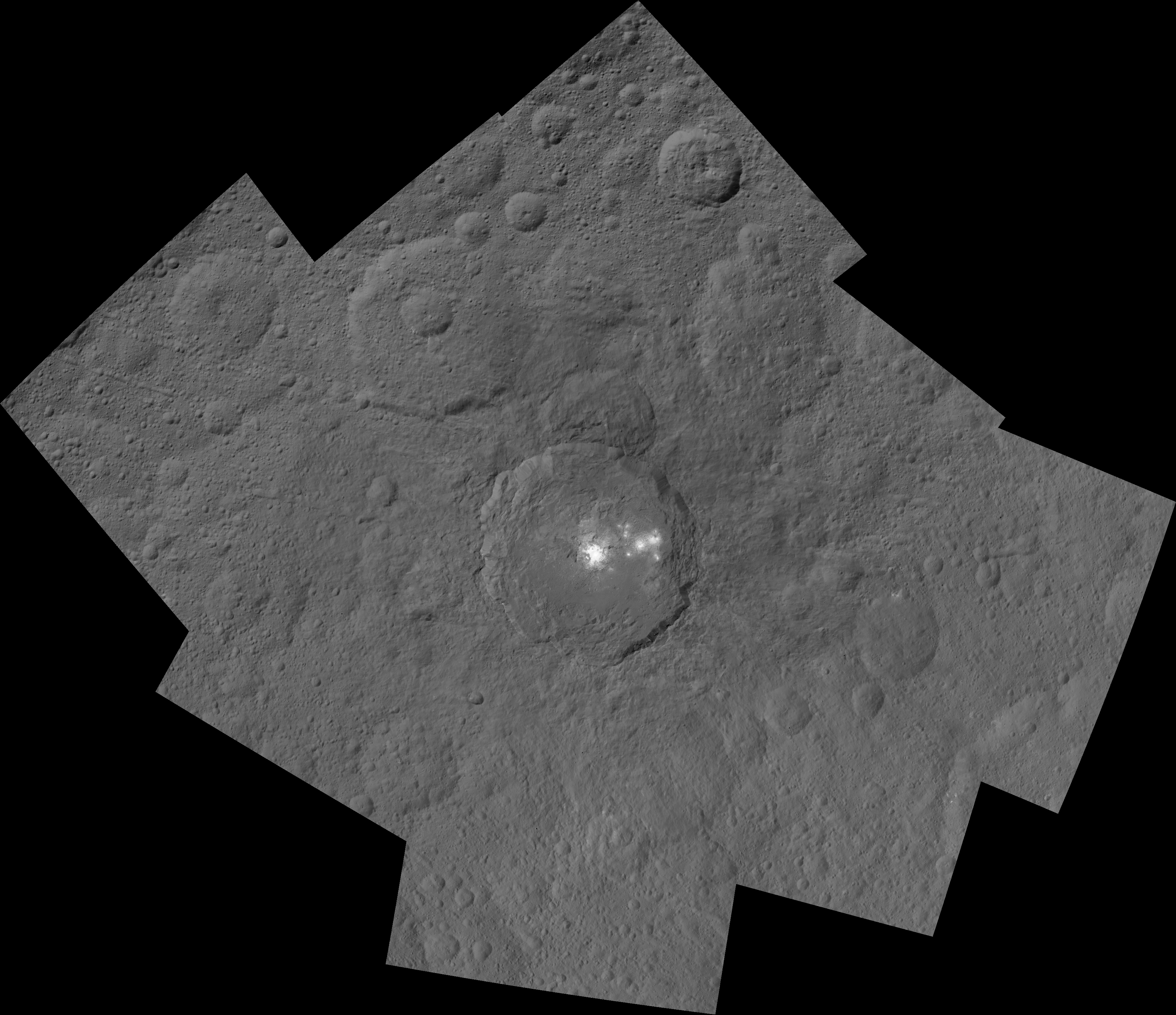
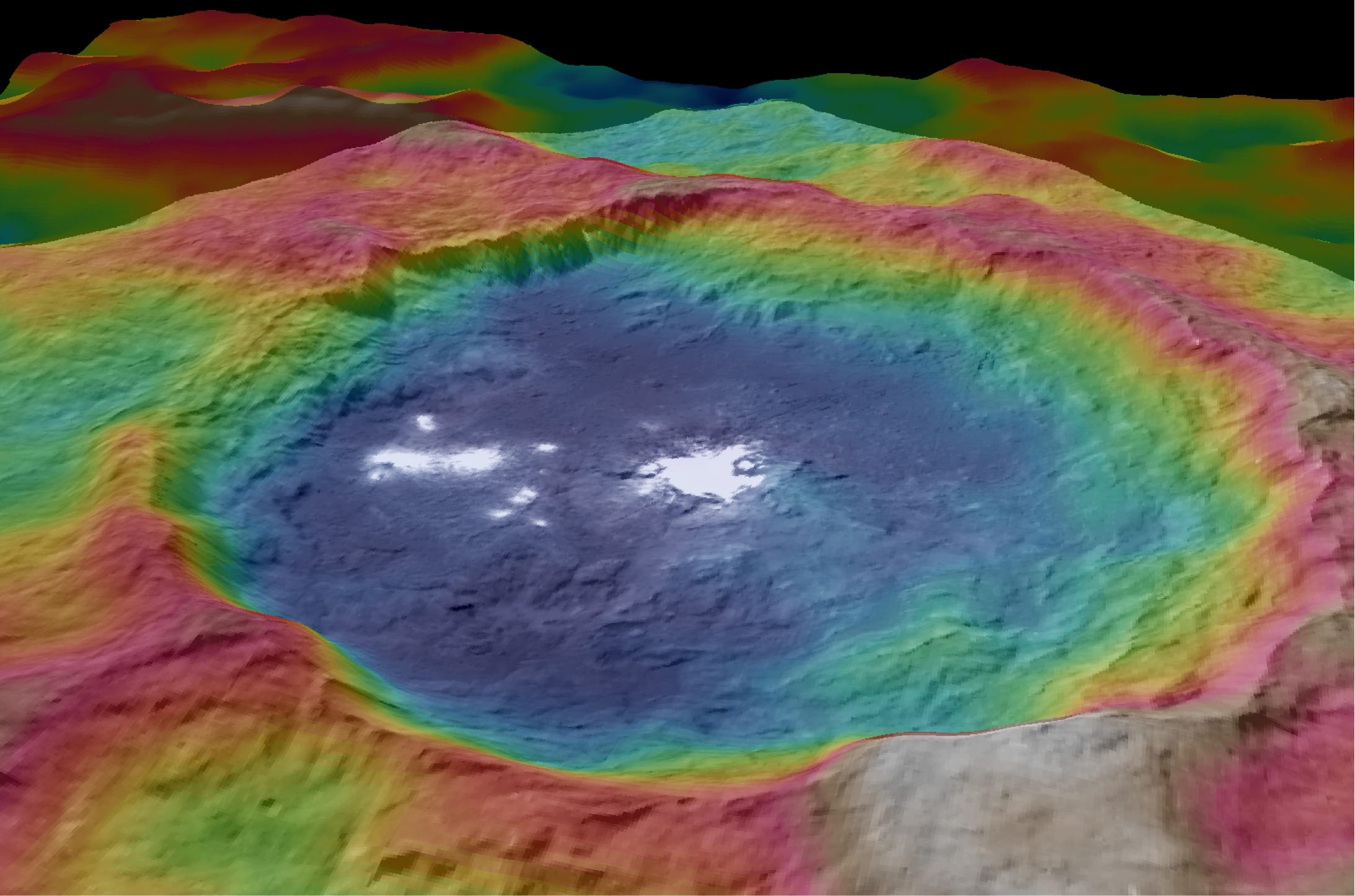
This mosaic shows Ceres' Occator crater and surrounding terrain from an altitude of 915 miles (1,470 kilometers), as seen by NASA's Dawn spacecraft. Occator is about 60 miles (90 kilometers) across and 2 miles (4 kilometers) deep. Credits: NASA/JPL-Caltech/UCLA/MPS/DLR/IDA
The most dazzling views ever seen of dwarf planet Ceres and its mysterious bright spots are what’s on tap by year’s end as NASA’s amazing Dawn spacecraft starts a gradual but steep descent over the next two months to its lowest and final orbit around the bizarre icy body.
Engineers at NASA’s Jet Propulsion Laboratory (JPL) successfully fired up the probes exotic ion propulsion system to begin lowering Dawn’s orbital altitude to less than a quarter of what it has been for the past two months of intense mapping operations.
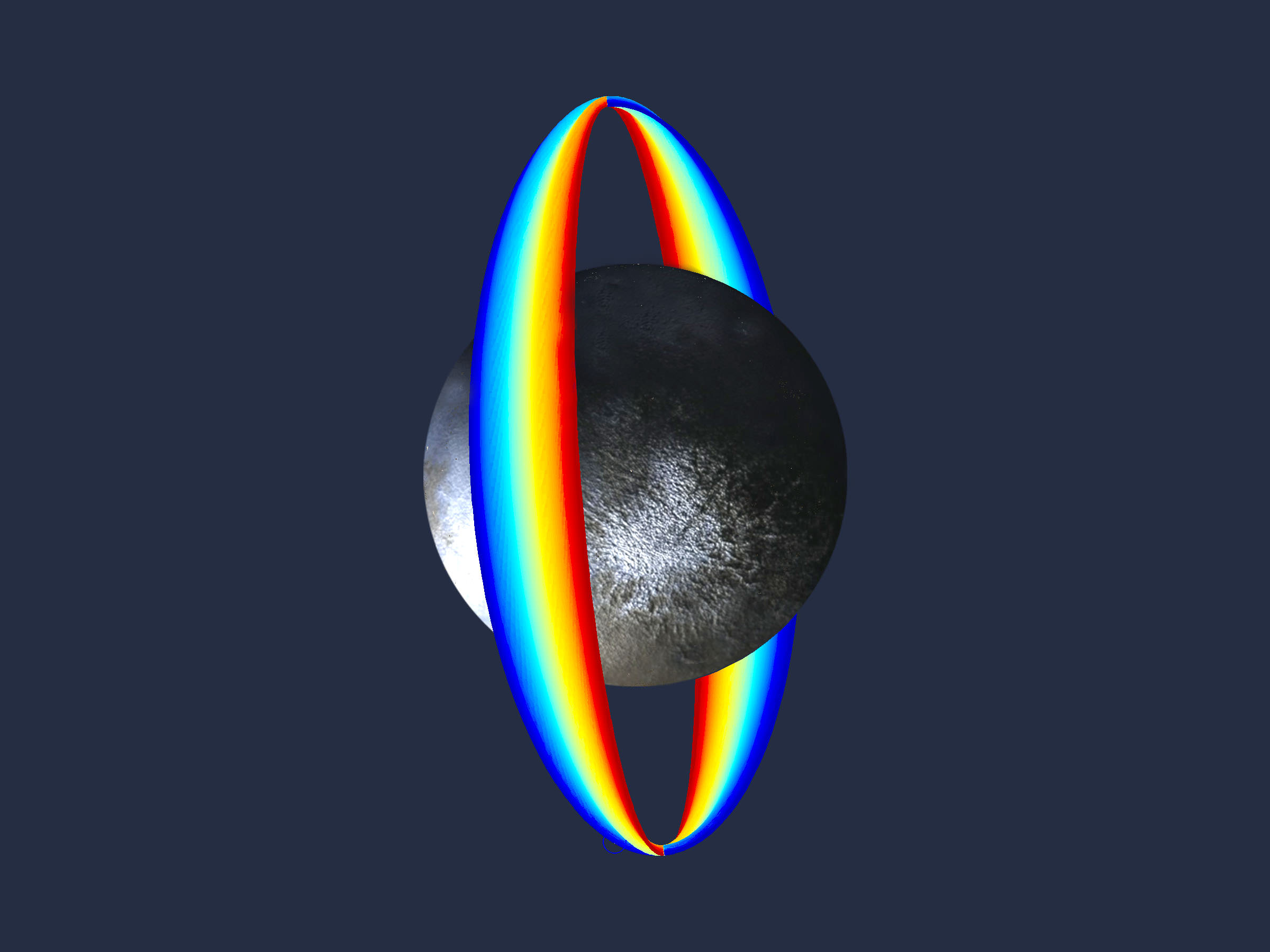
On Oct. 23, Dawn began a seven-week-long dive that uses ion thruster #2 to reduce the spacecrafts vantage point from 915 miles (1,470 kilometers) at the High Altitude Mapping Orbit (HAMO) down to less than 235 miles (380 kilometers) above Ceres at the Low Altitude Mapping Orbit (LAMO).
Dawn is slated to arrive at LAMO by mid-December, just in time to begin delivering the long awaiting Christmas treats.
Ceres has absolutely tantalized researchers far beyond their wildest expectations.
When Dawn arrives at LAMO it will be the culmination of an eight year interplanetary voyage that began with a blastoff on September 27, 2007 by a United Launch Alliance (ULA) Delta II Heavy rocket from Space Launch Complex-17B (SLC-17B) at Cape Canaveral Air Force Station, Florida.
LAMO marks Dawn’s fourth, lowest and final science orbit at Ceres where the highest resolution observations will be gathered and images from the framing camera will achieve a resolution of 120 feet (35 meters) per pixel.
Dawn’s low altitude mapping orbit LAMO. This shows how the orbit naturally shifts slightly (relative to the sun) during the three months of LAMO, starting in blue and ending in red. The spacecraft completes each revolution in 5.5 hours, and Ceres rotates in 9.1 hours, so Dawn will be able to view the entire surface. Credit: NASA/JPL
At LAMO, researchers hope to finally resolve the enduring mystery of the nature of the bright spots that have intrigued science and the general public since they were first glimpsed clearly early this year as Dawn was on its final approach to Ceres.
Dawn arrived in orbit this past spring on March 6, 2015.
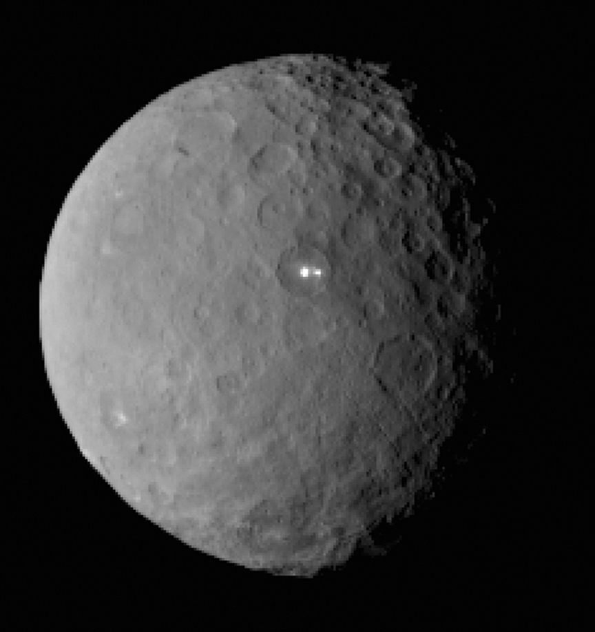
This image was taken by NASA’s Dawn spacecraft of dwarf planet Ceres on Feb. 19 from a distance of nearly 29,000 miles (46,000 km). It shows that the brightest spot on Ceres has a dimmer companion, which apparently lies in the same basin. See below for the wide view. Credit: NASA/JPL-Caltech/UCLA/MPS/DLR/IDA
The science team has just released a new mosaic of the brightest spots on Ceres found at Occator crater and the surrounding terrain – see above.
The images were taken from the HAMO altitude of 915 miles (1,470 kilometers) during the first of six mapping cycles. They have a resolution of 450 feet (140 meters) per pixel.
Occator measures about 60 miles (90 kilometers) across and 2 miles (4 kilometers) deep.
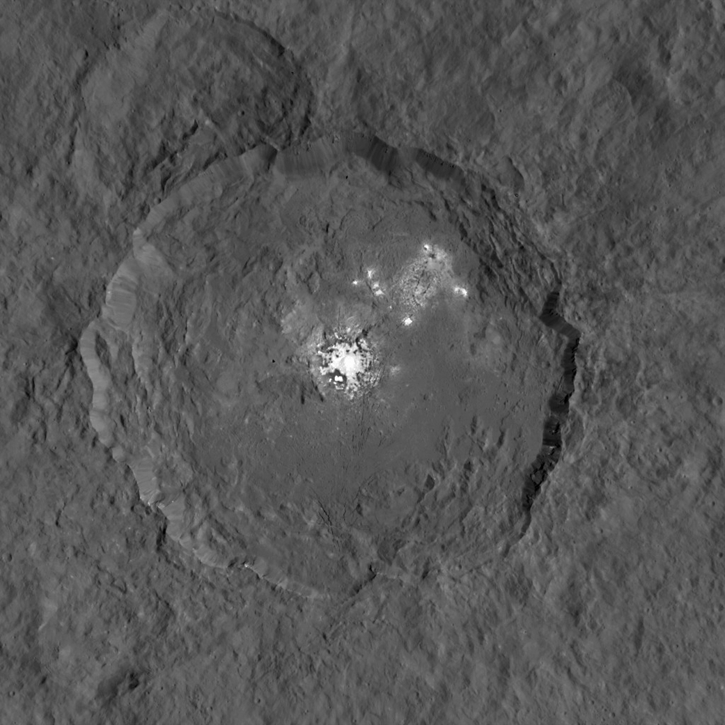
This image, made using images taken by NASA’s Dawn spacecraft during the mission’s High Altitude Mapping Orbit (HAMO) phase, shows Occator crater on Ceres, home to a collection of intriguing bright spots. Credits: NASA/JPL-Caltech/UCLA/MPS/DLR/IDA
Because the spots are so bright they are generally overexposed. Therefore the team took two sets of images, with shorter and longer exposure times, to maximize the details of the interior of Occator.
“This view uses a composite of two images of Occator: one using a short exposure that captures the detail in the bright spots, and one where the background surface is captured at normal exposure.”
The bright spots at Occator crater remain the biggest Cerean mystery.
So far the imagery and other science data may point to evaporation of salty water from the interior as the source of the bright spots.
“Occasional water leakage on to the surface could leave salt there as the water would sublime,” Prof. Chris Russell, Dawn principal investigator told Universe Today exclusively.
“The big picture that is emerging is that Ceres fills a unique niche.”
“Ceres fills a unique niche between the cold icy bodies of the outer solar system, with their rock hard icy surfaces, and the water planets Mars and Earth that can support ice and water on their surfaces,” Russell, of the University of California, Los Angeles, told me.
Dawn has peeled back Ceres secrets as the spacecraft orbits lower and lower. Detailed measurements gathered to date have yielded global mineral and topographic maps from HAMO with the best resolution ever as the science team painstakingly stitched together the probes spectral and imaging products.
And the best is yet to come at LAMO.
At HAMO, Dawn’ instruments, including the Framing Camera and Visible and Infrared Spectrometer (VIR) were aimed at slightly different angles in each mapping cycle allowing the team to generate stereo views and construct 3-D maps.
“The emphasis during HAMO is to get good stereo data on the elevations of the surface topography and to get good high resolution clear and color data with the framing camera,” Russell explained.
This view from NASA’s Dawn spacecraft is a color-coded topographic map of Occator crater on Ceres. Blue is the lowest elevation, and brown is the highest. The crater, which is home to the brightest spots on Ceres, is approximately 56 miles (90 kilometers wide). Credits: NASA/JPL-Caltech/UCLA/MPS/DLR/IDA
Dawn is Earth’s first probe in human history to explore any dwarf planet, the first to explore Ceres up close and the first to orbit two celestial bodies.
The asteroid Vesta was Dawn’s first orbital target where it conducted extensive observations of the bizarre world for over a year in 2011 and 2012.
Ceres is a Texas-sized world, ranks as the largest object in the main asteroid belt between Mars and Jupiter, and may have a subsurface ocean of liquid water that could be hospitable to life.
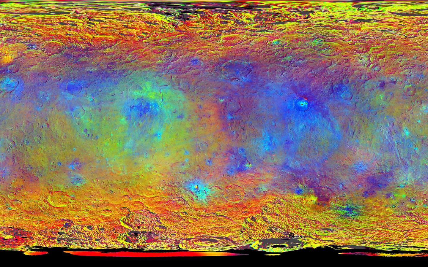
This map-projected view of Ceres was created from images taken by NASA’s Dawn spacecraft during its high-altitude mapping orbit, in August and September, 2015. This color coded map can provide valuable insights into the mineral composition of the surface, as well as the relative ages of surface features. Credits: NASA/JPL-Caltech/UCLA/MPS/DLR/IDA
The mission is expected to last until at least March 2016, and possibly longer, depending upon fuel reserves.
“It will end some time between March and December,” Dr. Marc Rayman, Dawn’s chief engineer and mission director based at NASA’s Jet Propulsion Laboratory, Pasadena, California, told Universe Today.
Stay tuned here for Ken’s continuing Earth and planetary science and human spaceflight news.
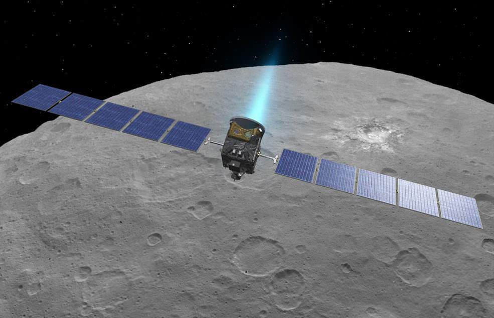
An artist’s conception shows NASA’s Dawn spacecraft flying above Ceres. This view incorporates actual imagery from the Dawn mission. Credit: NASA/JPL-Caltech/UCLA/MPS/DLR/IDA
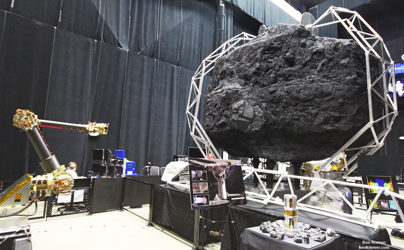
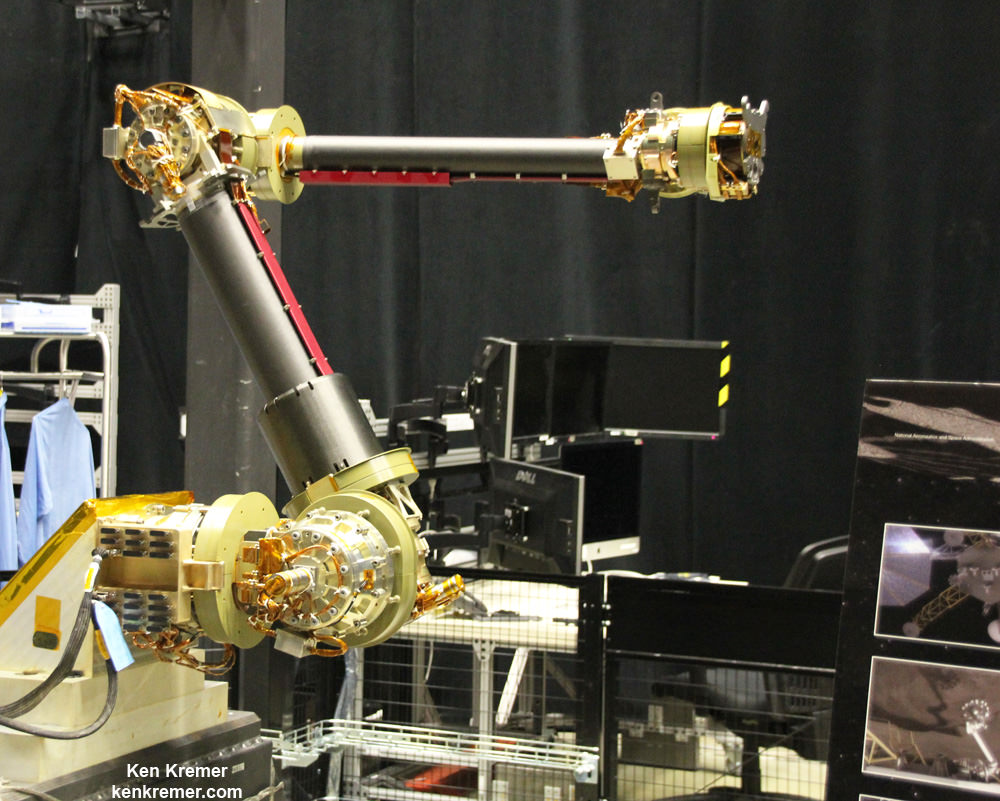
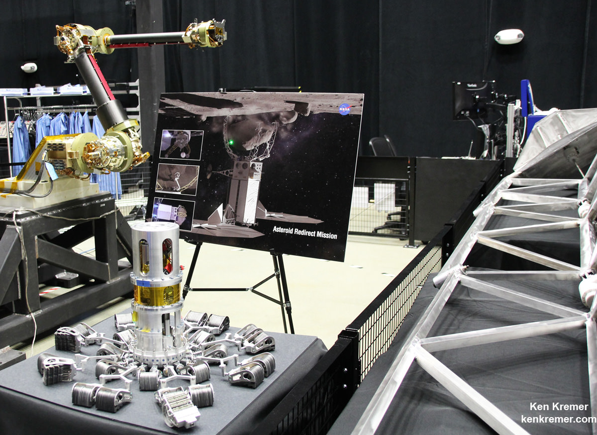
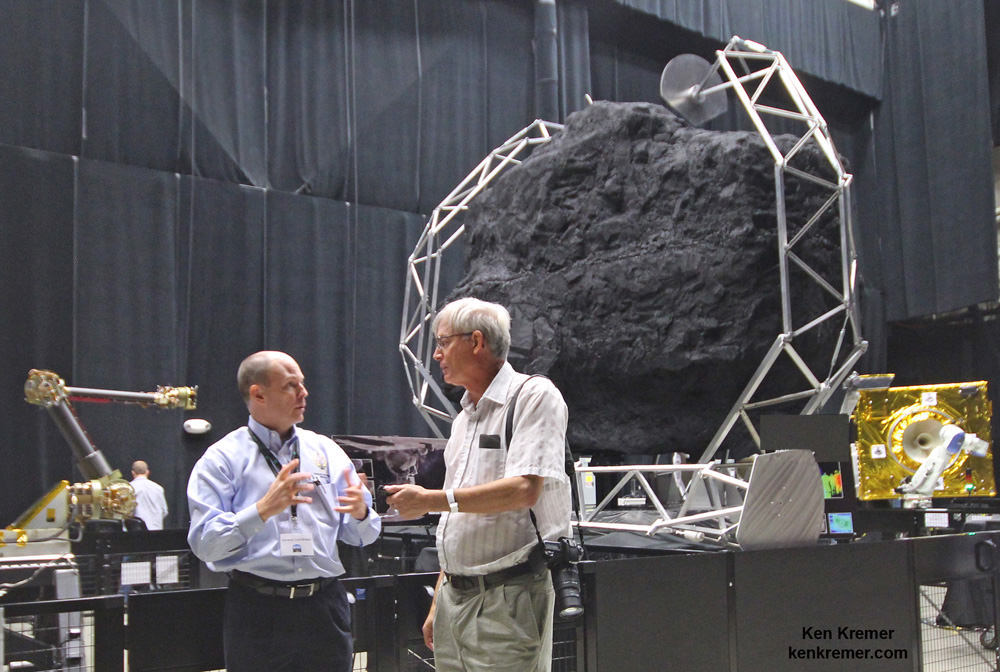
Robotic sampling arm and capture mechanism to collect a multi-ton boulder from an asteroid are under development at NASA Goddard and other agency centers for NASA’s unmanned Asteroid Redirect Vehicle and eventual docking in lunar orbit with Orion crew vehicle by the mid 2020s. Credit: Ken Kremer/kenkremer.com
NASA GODDARD SPACE FLIGHT CENTER, MD – Rigorous testing has begun on the advanced robotic arm and boulder extraction mechanisms that are key components of the unmanned probe at the heart of NASA’s Asteroid Redirect Robotic Mission (ARRM) now under development to pluck a multi-ton boulder off a near-Earth asteroid so that astronauts visiting later in an Orion crew capsule can harvest a large quantity of samples for high powered scientific analysis back on Earth. Universe Today inspected the robotic arm hardware utilizing “leveraged robotic technology” during an up close visit and exclusive interview with the engineering development team at NASA Goddard.
“The teams are making great progress on the capture mechanism that has been delivered to the robotics team at Goddard from Langley,” NASA Associate Administrator Robert Lightfoot told Universe Today.
“NASA is developing these common technologies for a suite of missions like satellite servicing and refueling in low Earth orbit as well as autonomously capturing an asteroid about 100 million miles away,” said Ben Reed, NASA Satellite Servicing Capabilities Office (SSCO) Deputy Project Manager, during an exclusive interview and hardware tour with Universe Today at NASA Goddard in Greenbelt, Maryland, regarding concepts and goals for the overall Asteroid Redirect Mission (ARM) initiative.
NASA is leveraging technology originally developed for satellite servicing such as with the Robotic Refueling Mission (RRM) currently on board the International Space Station(ISS) and repurposing them for the asteroid retrieval mission.
“Those are our two near term mission objectives that we are developing these technologies for,” Reed explained.
The unmanned Asteroid Redirect Robotic Mission (ARRM) to grab a boulder is the essential first step towards carrying out the follow on sample retrieval with the manned Orion Asteroid Redirect Mission (ARM) by the mid-2020s.
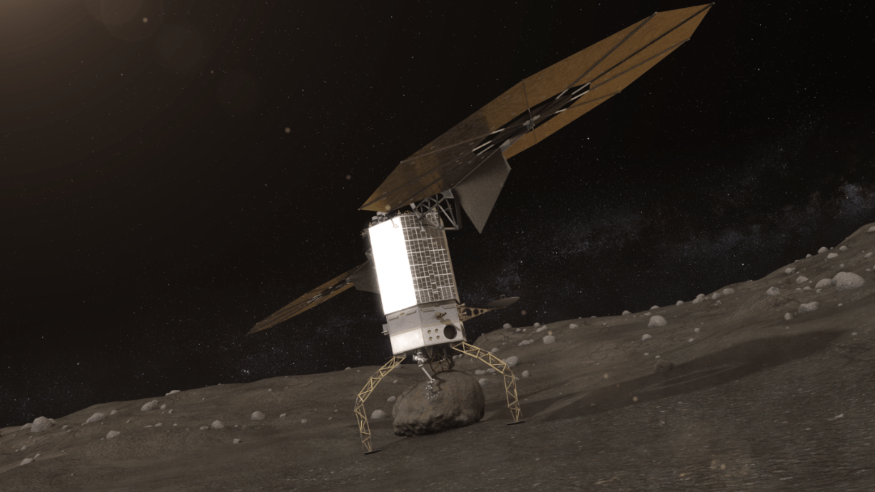
ARRM will use a pair of highly capable robotic arms to autonomously grapple a multi-ton (> 20 ton) boulder off the surface of a large near-Earth asteroid and transport it to a stable, astronaut accessible orbit around the Moon in cislunar space.
“Things are moving well. The teams have made really tremendous progress on the robotic arm and capture mechanism,” Bill Gerstenmaier, NASA Associate Administrator for Human Exploration and Operations, told Universe Today.
Then an Orion crew capsule can fly to it and the astronauts will collect a large quantity of rock samples and gather additional scientific measurements.
“We are working on a system to rendezvous, capture and service different [target] clients using the same technologies. That is what we are working on in a nut shell,” Reed said.
This engineering design unit of the robotic servicing arm is under development to autonomously extract a boulder off an asteroid for NASA’s asteroid retrieval mission and is being tested at NASA Goddard. It has seven degrees of freedom and mimics a human arm. Credit: Ken Kremer/kenkremer.com
“Right now the plan is to launch ARRM by about December 2020,” Reed told me. But a huge amount of preparatory work across the US is required to turn NASA’s plan into reality.
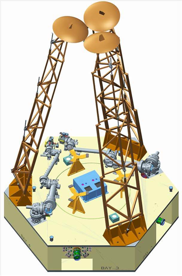
Key mission enabling technologies are being tested right now with a new full scale engineering model of the ‘Robotic Servicing Arm’ and a full scale mockup of the boulder snatching ARRM Capture Module at NASA Goddard, in a new facility known as “The Cauldron.”
Capture Module comprising two robotic servicing arms and three boulder grappling contact and restraint system legs for NASA’s Asteroid Redirect Robotic Mission (ARRM). Credit: NASAThe ARRM capture module is comprised of two shorter robotic arms (separated by 180 degrees) and three lengthy contact and restraint system capture legs (separated by 120 degrees) attached to a cradle with associated avionics, computers and electronics and the rest of the spacecraft and solar electric power arrays.
“The robotic arm we have here now is an engineering development unit. The 2.2 meter-long arms can be used for assembling large telescopes, repairing a failed satellite, removing orbital debris and capturing an asteroid,” said Reed.
“There are two little arms and three big capture legs.”
“So, we are leveraging one technology development program into multiple NASA objectives.”
“We are working on common technologies that can service a legacy orbiting satellite, not designed to be serviced, and use those same technologies with some tweaking that we can go out with 100 million miles and capture an asteroid and bring it back to the vicinity of the Moon.”
“Currently the [capture module] system can handle a boulder that’s up to about 3 x 4 x 5 meters in diameter.”
Artists concept of NASA’s Asteroid Redirect Robotic Mission capturing an asteroid boulder before redirecting it to a astronaut-accessible orbit around Earth’s moon. Credits: NASA
The Cauldron is a brand new Goddard facility for testing technologies and operations for multiple exploration and science missions, including satellite servicing and ARRM that just opened in June 2015 for the centers Satellite Servicing Capabilities Office.
Overall project lead for ARRM is the Jet Propulsion Laboratory (JPL) with numerous contributions from other NASA centers and industrial partners.
“This is an immersive development lab where we bring systems together and can do lifetime testing to simulate what’s in space. This is our robotic equivalent to the astronauts NBL, or neutral buoyancy lab,” Reed elaborated.
“So with this same robotic arm that can cut wires and thermal blankets and refuel an Earth sensing satellite, we can now have that same arm go out on a different mission and be able to travel out and pick up a multi-ton boulder and bring it back for astronauts to harvest samples from.”
“So that’s quite a technical feat!”
The Robotic Servicing Arm is a multi-jointed powerhouse designed to function like a “human arm” as much as possible. It builds on extensive prior research and development investment efforts conducted for NASA’s current Red Planetrovers and a flight-qualified robotic arm developed for the Defense Advanced Research Projects Agency (DARPA).
“The arm is capable of seven-degrees-of-freedom to mimic the full functionally of a human arm. It has heritage from the arm on Mars right now on Curiosity as well as ground based programs from DARPA,” Reed told me.
“It has three degrees of freedom at our shoulder, two at our elbow and two more at the wrist. So I can hold the hand still and move the elbow.”
The arm will also be equipped with a variety of interchangeable “hands” that are basically tools to carry out different tasks with the asteroid such as grappling, drilling, sample gathering, imaging and spectrometric analysis, etc.
View of the robotic arm above and gripper tool below that initially grabs the asteroid boulder before the capture legs wrap around as planned for NASA’s upcoming unmanned ARRM Asteroid Redirect Robotic Mission that will later dock with an Orion crew vehicle. Credit: Ken Kremer/kenkremer.com
The ARRM spacecraft will carefully study, characterize and photograph the asteroid in great detail for about a month before attempting the boulder capture.
Why does the arm need all this human-like capability?
“When we arrive at an asteroid that’s 100 million miles away, we are not going to know the fine local geometry until we arrive,” Reed explained to Universe Today.
“Therefore we need a flexible enough arm that can accommodate local geometries at the multi-foot scale. And then a gripper tool that can handle those geometry facets at a much smaller scale.”
“Therefore we chose seven-degrees-of-freedom to mimic humans very much by design. We also need seven-degrees-of-freedom to conduct collision avoidance maneuvers. You can’t do that with a six-degree-of-freedom arm. It has to be seven to be a general purpose arm.”
How will the ARRM capture module work to snatch the boulder off the asteroid?
“So the idea is you come to the mother asteroid and touch down and make contact on the surface. Then you hold that position and the two arms reach out and grab the boulder.”
“Once its grabbed the boulder, then the legs straighten and pull the boulder off the surface.”
“Then the arms nestle the asteroid onto a cradle. And the legs then change from a contact system to become a restraint system. So the legs wrap around the boulder to restrain it for the 100 million mile journey back home.
“After that the little arms can let go – because the legs have wrapped around and are holding the asteroid.”
“So now the arm can also let go of the gripper system and pick up a different tool to do other things. For example they can collect a sample with another tool. And maybe assist an astronaut after the crew arrives.”
“During the 100 million mile journey back to lunar orbit they can be also be preparing the surface and cutting into it for later sample collection by the astronauts.”
Be sure to watch this video animation:
Since the actual asteroid encounter will occur very far away, the boulder grappling will have to be done fully autonomously since there will be no possibility for real time communications.
“The return time for communications is like about 30 minutes. So ‘human in the loop’ control is out of the question.
“Once we get into hover position over the landing site we hit the GO button. Then it will be very much like at Mars and the seven minutes of terror. It will take awhile to find out if it worked.”
Therefore the team at Goddard has already spent years of effort and practice sessions just to get ready for working with the early engineering version of the arm to maximize the probability of a successful capture.
“In this facility we put systems together to try and practice and rehearse and simulate as much of the mission as is realistically possible.”
“It took a lot of effort to get to this point, in the neighborhood of four years to get the simulation to behave correctly in real time with contact dynamics and the robotic systems. So the arm has to touch the boulder with force torque sensors and feed that into a computer to measure that and move the actuators to respond accordingly.”
“So the capture of the boulder is autonomous. The rest is teleoperated from the ground, but not the capture itself.”
How realistic are the rehearsals?
“We are practicing here by reaching out with the arm to grasp the client target using autonomous capture [procedures]. In space the client [target] is floating and maybe tumbling. So when we reach out with the arm to practice autonomous capture we make the client tumble and move – with the inertial properties of the target we are practicing on.”
“Now for known objects like satellites we know the mass precisely. And we can program all that inertial property data in very accurately to give us much more realistic simulations.”
“We learned from all our astronaut servicing experiences in orbit is that the more we know for the simulations, the easier and better the results are for the astronauts during an actual mission because you simulated all the properties.”
“But with this robotic mission to an asteroid there is no backup like astronauts. So we want to practice here at Goddard and simulate the space environment.”
ARRM will launch by the end of 2020 on either an SLS, Delta IV Heavy or a Falcon Heavy. NASA has not yet chosen the launch vehicle.
Several candidate asteroids have already been discovered and NASA has an extensive ongoing program to find more.
Orion crew capsule docks to NASA’s asteroid redirect vehicle grappling captured asteroid boulder orbiting the Moon. Credit: NASA
Again, this robotic technology was selected for development for ARRM because it has a lot in common with other objectives like fixing communications satellites, refueling satellites and building large telescopes in the future.
NASA is also developing other critical enabling technologies for the entire ARM project like solar electric propulsion that will be the subject of another article.
Therefore NASA is leveraging one technology development program into multiple spaceflight objectives that will greatly assist its plans to send ‘Humans to Mars’ in the 2030s with the Orion crew module launched by the monster Space Launch System (SLS) rocket.
The maiden uncrewed launch of the Orion/SLS stack is slated for November 2018.
Stay tuned here for Ken’s continuing Earth and Planetary science and human spaceflight news.
At NASA Goddard robotics lab Ben Reed/NASA Satellite Servicing Capabilities Office (SSCO) Deputy Project Manager and Ken Kremer/Universe Today discuss the robotic servicing arm and asteroid boulder capture mechanism being tested for NASA’s upcoming unmanned ARRM Asteroid Redirect Robotic Mission that will dock with an Orion crew vehicle in lunar orbit by the mid 2020s for sample return collection. Credit: Ken Kremer/kenkremer.com
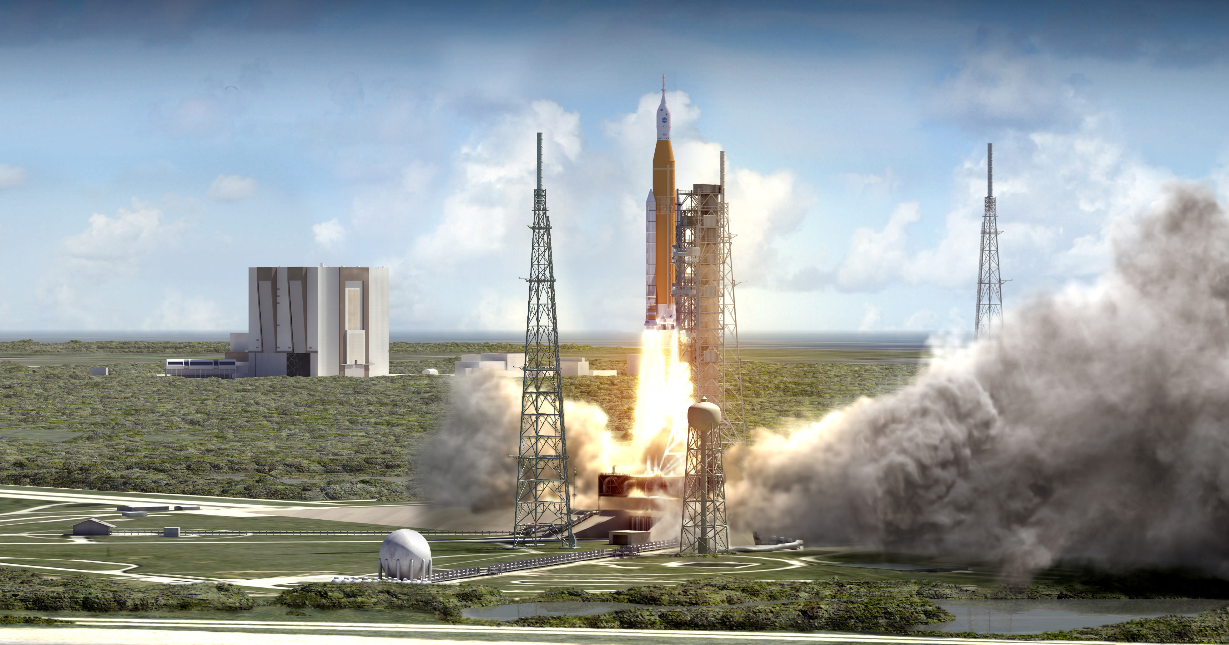
NASA’s Space Launch System (SLS) blasts off from launch pad 39B at the Kennedy Space Center in this artist rendering showing a view of the liftoff of the Block 1 70-metric-ton (77-ton) crew vehicle configuration. Credit: NASA/MSFC
NASA’s Space Launch System (SLS) blasts off from launch pad 39B at the Kennedy Space Center in this artist rendering showing a view of the liftoff of the Block 1 70-metric-ton (77-ton) crew vehicle configuration. Credit: NASA/MSFC
Story/imagery updated[/caption]
The SLS, America’s first human-rated heavy lift rocket intended to carry astronautsto deep space destinations since NASA’s Apollomoon landing era Saturn V, has passed a key design milestone known as the critical design review (CDR) thereby clearing the path to full scale fabrication.
NASA also confirmed they have dropped the Saturn V white color motif of the mammoth rocket in favor of burnt orange to reflect the natural color of the SLS boosters first stage cryogenic core. The agency also decided to add stripes to the huge solid rocket boosters.
NASA announced that the Space Launch System (SLS) has “completed all steps needed to clear a critical design review (CDR)” – meaning that the design of all the rockets components are technically acceptable and the agency can continue with full scale production towards achieving a maiden liftoff from the Kennedy Space Center in Florida in 2018.
“We’ve nailed down the design of SLS,” said Bill Hill, deputy associate administrator of NASA’s Exploration Systems Development Division, in a NASA statement.
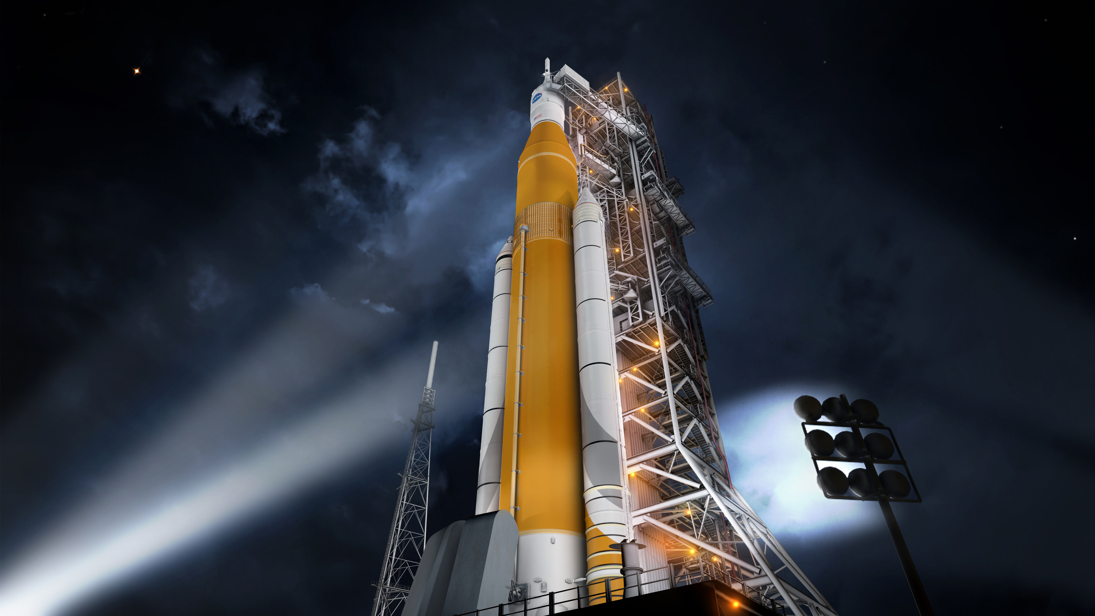
Artist concept of the SLS Block 1 configuration on the Mobile Launcher at KSC. Credit: NASA/MSFC
Blastoff of the NASA’s first SLS heavy lift booster (SLS-1) carrying an unmanned test version of NASA’s Orioncrew capsule is targeted for no later than November 2018.
Indeed the SLS will be the most powerful rocket the world has ever seen starting with its first liftoff. It will propel our astronauts on journey’s further into space than ever before.
SLS is “the first vehicle designed to meet the challenges of the journey to Mars and the first exploration class rocket since the Saturn V.”
Crews seated inside NASA’s Orion crew module bolted atop the SLS will rocket to deep space destinations including the Moon, asteroids and eventually the Red Planet.
“There have been challenges, and there will be more ahead, but this review gives us confidence that we are on the right track for the first flight of SLS and using it to extend permanent human presence into deep space,” Hill stated.
The core stage (first stage) of the SLS will be powered by four RS-25 engines and a pair of five-segment solid rocket boosters (SRBs) that will generate a combined 8.4 million pounds of liftoff thrust in its inaugural Block 1 configuration, with a minimum 70-metric-ton (77-ton) lift capability.
Overall the SLS Block 1 configuration will be some 10 percent more powerful than the Saturn V rockets that propelled astronauts to the Moon, including Neil Armstrong, the first human to walk on the Moon during Apollo 11 in July 1969.
Graphic shows Block I configuration of NASA’s Space Launch System (SLS). Credits: NASA/MSFC
The SLS core stage is derived from the huge External Tank (ET) that fueled NASA Space Shuttle’s for three decades. It is a longer version of the Shuttle ET.
NASA initially planned to paint the SLS core stage white, thereby making it resemble the Saturn V.
But since the natural manufacturing color of its insulation during fabrication is burnt orange, managers decided to keep it so and delete the white paint job.
“As part of the CDR, the program concluded the core stage of the rocket and Launch Vehicle Stage Adapter will remain orange, the natural color of the insulation that will cover those elements, instead of painted white,” said NASA.
There is good reason to scrap the white color motif because roughly 1000 pounds of paint can be saved by leaving the tank with its natural orange pigment.
This translates directly into another 1000 pounds of payload carrying capability to orbit.
“Not applying the paint will reduce the vehicle mass by potentially as much as 1,000 pounds, resulting in an increase in payload capacity, and additionally streamlines production processes,” Shannon Ridinger, NASA Public Affairs spokeswomen told Universe Today.
After the first two shuttle launches back in 1981, the ETs were also not painted white for the same reason – in order to carry more cargo to orbit.
“This is similar to what was done for the external tank for the space shuttle. The space shuttle was originally painted white for the first two flights and later a technical study found painting to be unnecessary,” Ridinger explained.
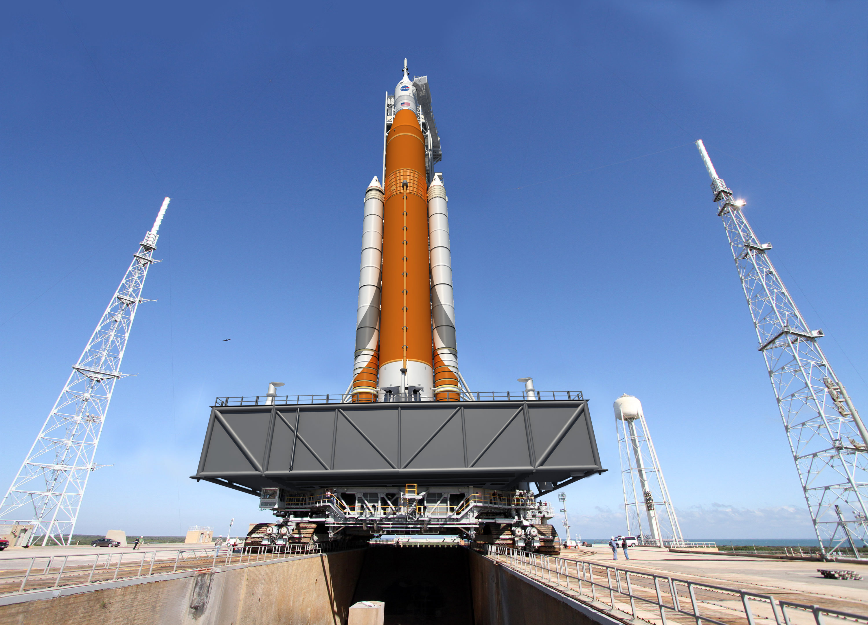
Artist concept of the Block I configuration of NASA’s Space Launch System (SLS). The SLS Program has completed its critical design review, and the program has concluded that the core stage of the rocket will remain orange along with the Launch Vehicle Stage Adapter, which is the natural color of the insulation that will cover those elements. Credits: NASA
NASA said that the CDR was completed by the SLS team in July and the results were also further reviewed over several more months by a panel of outside experts and additionally by top NASA managers.
“The SLS Program completed the review in July, in conjunction with a separate review by the Standing Review Board, which is composed of seasoned experts from NASA and industry who are independent of the program. Throughout the course of 11 weeks, 13 teams – made up of senior engineers and aerospace experts across the agency and industry – reviewed more than 1,000 SLS documents and more than 150 GB of data as part of the comprehensive assessment process at NASA’s Marshall Space Flight Center in Huntsville, Alabama, where SLS is managed for the agency.”
“The Standing Review Board reviewed and assessed the program’s readiness and confirmed the technical effort is on track to complete system development and meet performance requirements on budget and on schedule.”
The final step of the SLS CDR was completed this month with another extremely thorough assessment by NASA’s Agency Program Management Council, led by NASA Associate Administrator Robert Lightfoot.
“This is a major step in the design and readiness of SLS,” said John Honeycutt, SLS program manager.
The CDR was the last of four reviews that examine SLS concepts and designs.
NASA says the next step “is design certification, which will take place in 2017 after manufacturing, integration and testing is complete. The design certification will compare the actual final product to the rocket’s design. The final review, the flight readiness review, will take place just prior to the 2018 flight readiness date.”
“Our team has worked extremely hard, and we are moving forward with building this rocket. We are qualifying hardware, building structural test articles, and making real progress,” Honeycutt elaborated.
Numerous individual components of the SLS core stage have already been built and their manufacture was part of the CDR assessment.
The SLS core stage is being built at NASA’s Michoud Assembly Facility in New Orleans. It stretches over 200 feet tall and is 27.6 feet in diameter and will carry cryogenic liquid hydrogen and liquid oxygen fuel for the rocket’s four RS-25 engines.
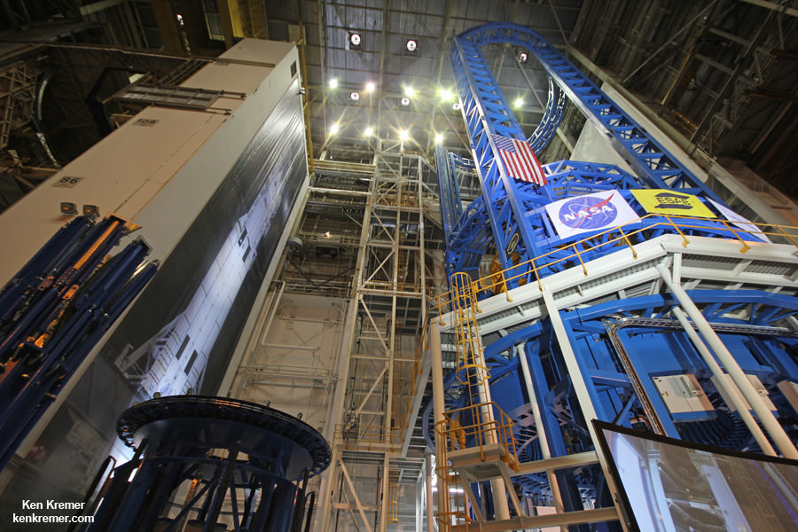
On Sept. 12, 2014, NASA Administrator Charles Bolden officially unveiled the world’s largest welder at Michoud, that will be used to construct the core stage, as I reported earlier during my on-site visit – here.
NASA decided that the SRBs will be painted with something like racing stripes.
“Stripes will be painted on the SRBs and we are still identifying the best process for putting them on the boosters; we have multiple options that have minimal impact to cost and payload capability, ” Ridinger stated.
With the successful completion of the CDR, the components of the first core stage can now proceed to assembly of the finished product and testing of the RS-25 engines and boosters can continue.
“We’ve successfully completed the first round of testing of the rocket’s engines and boosters, and all the major components for the first flight are now in production,” Hill explained.
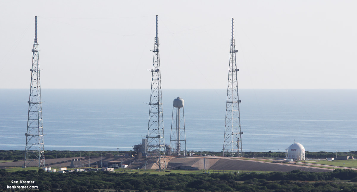
View of NASA’s future SLS/Orion launch pad at Space Launch Complex 39B from atop Mobile Launcher at the Kennedy Space Center in Florida. Former Space Shuttle launch pad 39B is now undergoing renovations and upgrades to prepare for SLS/Orion flights starting in 2018. Credit: Ken Kremer/kenkremer.com
NASA plans to gradually upgrade the SLS to achieve an unprecedented lift capability of 130 metric tons (143 tons), enabling the more distant missions even farther into our solar system.
The first SLS test flight with the uncrewed Orion is called Exploration Mission-1 (EM-1) and will launch from Launch Complex 39-B at the Kennedy Space Center (KSC).
The SLS/Orion stack will roll out to pad 39B atop the Mobile Launcher now under construction – as detailed in my recent story and during visit around and to the top of the ML at KSC.
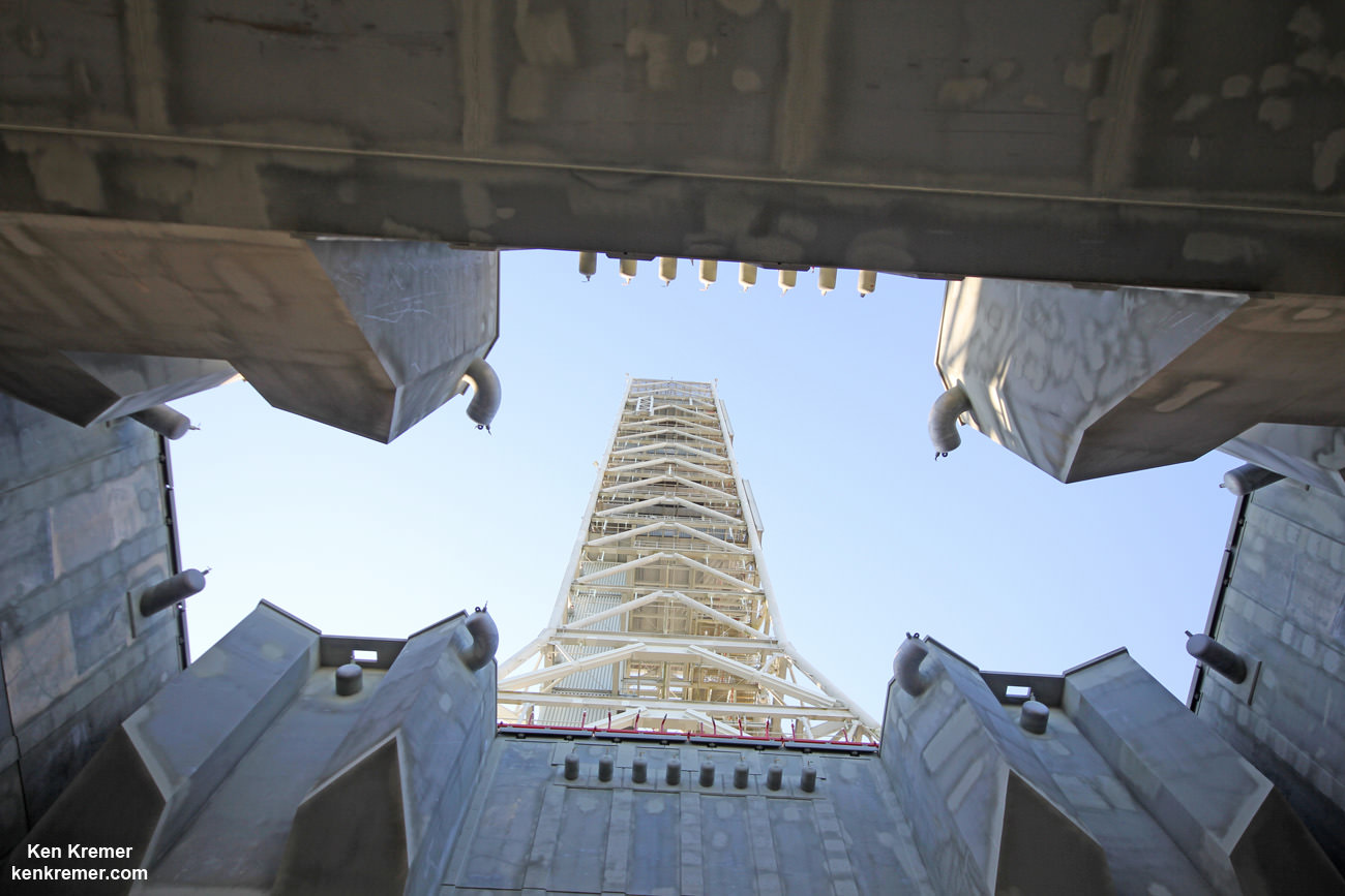
Looking up from beneath the enlarged exhaust hole of the Mobile Launcher to the 380 foot-tall tower astronauts will ascend as their gateway for missions to the Moon, Asteroids and Mars. The ML will support NASA’s Space Launch System (SLS) and Orion spacecraft during Exploration Mission-1 at NASA’s Kennedy Space Center in Florida. Credit: Ken Kremer/kenkremer.com
Orion’s inaugural mission dubbed Exploration Flight Test-1 (EFT) was successfully launched on a flawless flight on Dec. 5, 2014 atop a United Launch Alliance Delta IV Heavy rocket Space Launch Complex 37 (SLC-37) at Cape Canaveral Air Force Station in Florida.
Stay tuned here for Ken’s continuing Earth and Planetary science and human spaceflight news.
Wide view of the new welding tool at the Vertical Assembly Center at NASA’s Michoud Assembly Facility in New Orleans at a ribbon-cutting ceremony Sept. 12, 2014. Credit: Ken Kremer – kenkremer.com
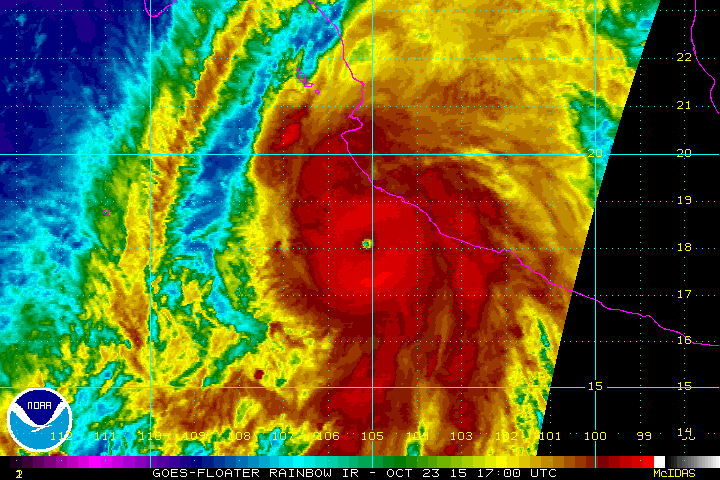
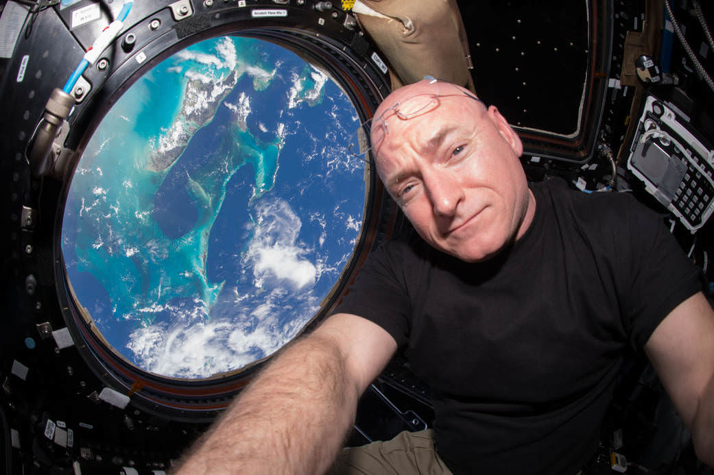
“Hurricane #Patricia approaches #Mexico. It's massive. Be careful” in this image taken by NASA astronaut Scott Kelly aboard the ISS on Oct. 23, 2015. Credit: NASA/Scott Kelly
“Hurricane #Patricia approaches #Mexico. It’s massive. Be careful” in this image taken by NASA astronaut Scott Kelly aboard the ISS on Oct. 23, 2015. Credit: NASA/Scott Kelly
More images and videos below[/caption]
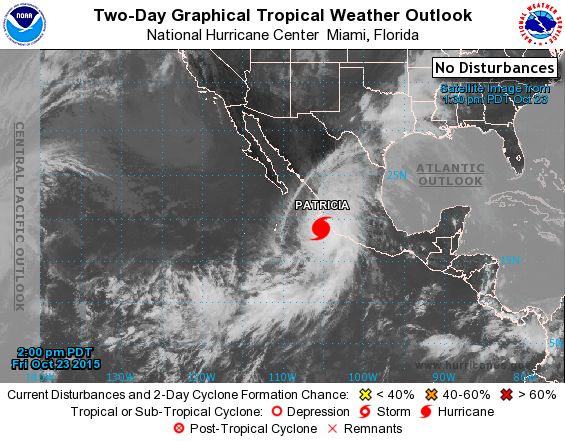
Hurricane Patricia, the strongest storm in recorded history with winds exceeding 190 mph (305 km/h) is right now menacing millions in Mexico after suddenly intensifying with little warning over the past day, threatening widespread catastrophic destruction as it barrels towards frightened residents along the nations Pacific coast and makes landfall this evening, Friday, Oct. 23.
Other NASA and NOAA weather satellites are actively monitoring and measuring the strongest storm on the planet right now.
“Hurricane #Patricia approaches #Mexico. It’s massive. Be careful,” Kelly wrote on his twitter account with a pair of images taken from the ISS.
Patricia unexpectedly intensified quite rapidly to a Category 5 storm from a tropical storm in the space of just 24 hours from yesterday to today with the significant potential for loss of life and likely widespread catastrophic damage.
This morning Patricia had sustained winds of 190 mph (305 km/h) , on the Saffir-Simpson Hurricane Wind Scale, with gusts up to 235 mph. That’s comparable to an EF-4 tornado, but its much wider.
Weather forecasters say that unusually warm waters, possibly from the current El Niño weather pattern may be causing the rapid intensification of the storm to unprecedented power never before seen.
On Oct. 23 at 17:30 UTC (1:30 p.m. EDT) NASA’s Terra satellite saw the eastern quadrant of Hurricane Patricia over Mexico and the storm’s pinhole eye. Credits: NASA’s Goddard MODIS Rapid Response Team
“Hurricane #Patricia looks menacing from @space_station. Stay safe below,” tweeted Kelly, who just broke the American record for most time spent in space.
Patricia is making landfall near the tourist resort of Puerto Vallarta, the town of Cuixmala and the city of Manzanillo along Mexico’s Pacific coast, as it slightly weakens to 165 mph (265 km/h) with destructive force.
Here is the latest Hurricane Patricia animation from NOAA:
Patricia is the most powerful storm ever to make landfall and many millions live in its path that is expected to track eastwards across inland areas of Mexico and then move up into the United States at Texas with flooding rains.
The Mexican government has warned millions to take shelter to evacuate. Over 15000 tourists have been evacuated from Puerto Vallarta to other regions. But the effort was hampered since the airport has been closed.
Catastrophic destruction to homes, businesses and infrastructure is feared.
Some 10 to 20 inches of rain is expected along the coast, causing mudslides across Mexico.
Waves heights exceeding 30 feet are also expected.
Heavy rains and flash flooding will continue into the US with the heaviest downpours expected in Texas and Louisiana.
Hurricane Patricia on Oct. 23, 2015 from the National Hurricane Center
Here’s the 7 PM CDT advisory from the National Hurricane Center:
“EXTREMELY DANGEROUS HURRICANE PATRICIA MOVING FARTHER INLAND OVER SOUTHWESTERN MEXICO”
“The center of Hurricane Patricia was located near latitude 19.5 North, longitude 104.9 West. Patricia ismoving toward the north-northeast near 15 mph (24 km/h) and this motion is expected to continue with some increase in forward speed tonight and Saturday. On the forecast track, the center of Patricia should continue to move inland over southwestern Mexico.
Patricia is expected to move quickly north-northeastward across western and northern Mexico through Saturday.
Satellite images indicate that Patricia has continued to weaken, and maximum sustained winds are estimated to be near 160 mph (260 km/h) with higher gusts. Patricia is a category 5 hurricane on the Saffir-Simpson Hurricane Wind Scale. Patricia is forecast to rapidly weaken over the mountains of Mexico and dissipate on Saturday.
Hurricane force winds extend outward up to 35 miles (55 km) from the center and tropical storm force winds extend outward up to 175 miles (280 km).
The estimated minimum central pressure is 924 mb (27.29 inches).”
Here’s a video of Hurricane Patricia from the ISS taken today, Oct 23, 2015.
Video caption: Outside the International Space Station, cameras captured dramatic views of Hurricane Patricia at 12:15 p.m. EDT on October 23, 2015 as the mammoth system moved north at about 10 mph, heading for a potentially catastrophic landfall along the southwest coast of Mexico sometime during the day, according to the National Hurricane Center. Packing winds of 200 miles per hour, Patricia is the strongest in recorded history in the southeastern Pacific Ocean. The National Hurricane Center says that once Patricia crosses the Mexican coast it should weaken quickly and dissipate Oct. 24 due to upper level winds and mountainous terrain, but likely will introduce copious amounts of rainfall to the Texas coast through the weekend. Credit: NASA
Stay tuned here for Ken’s continuing Earth and planetary science and human spaceflight news.
Special Guest: Dr. Matthew Golombek, JPL Project Scientist for MER, and working on the NASA’s InSight (Interior Exploration using Seismic Investigations, Geodesy and Heat Transport) Discovery Program mission.
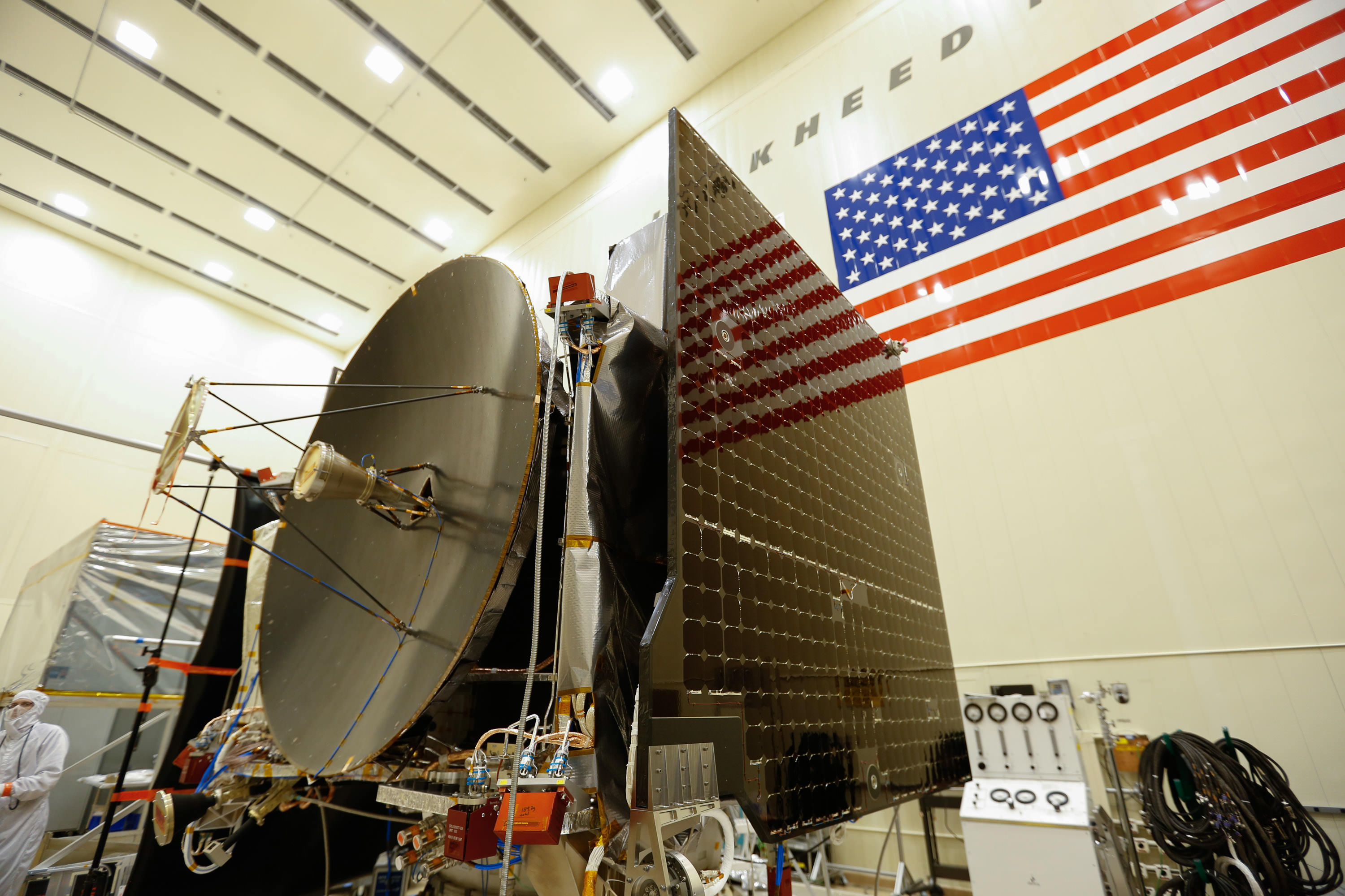
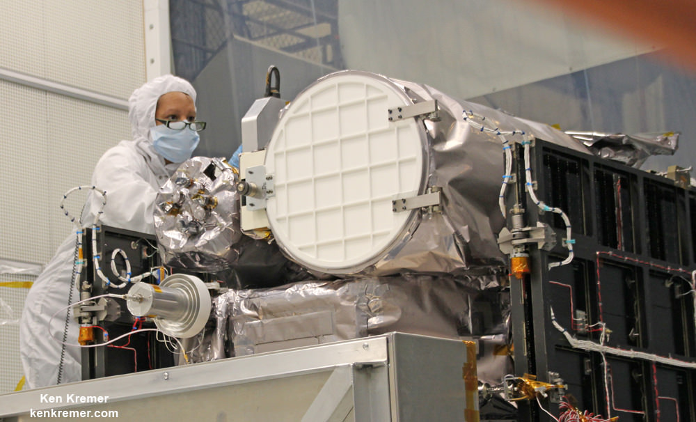
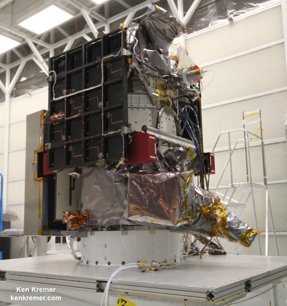
The high gain antenna and solar arrays were installed on the OSIRIS-REx spacecraft prior to it moving to environmental testing. Credits: Lockheed Martin Corporation
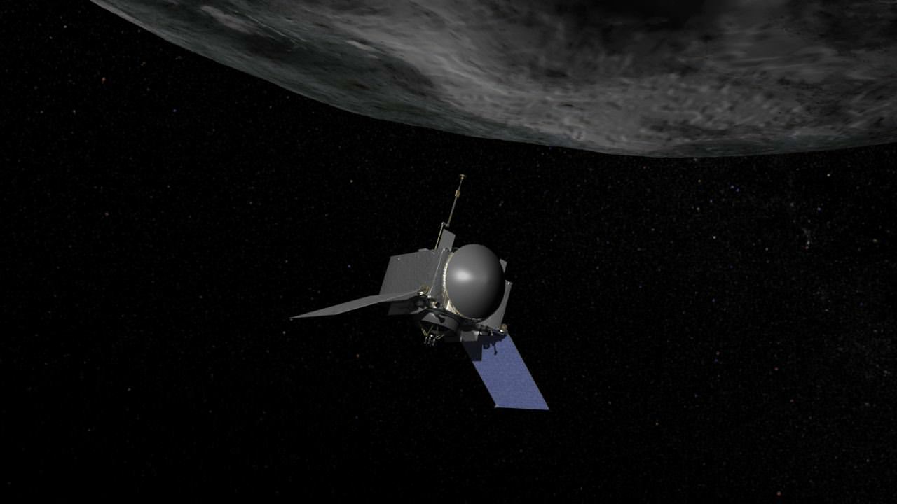
OSIRIS-Rex, the first American spacecraft ever aimed at snatching pristine samples from the surface of an asteroid and returning them to Earth for exquisite analysis by researchers world-wide with the most advanced science instruments has successfully completed its assembly phase and moved into the “test drive” phase – just ten months before blastoff, following installation of all its science instruments at Lockheed Martin Space Systems facilities, near Denver, Colorado.
The launch window for OSIRIS-REx opens next fall on September 3, 2016 on a seven-year journey to asteroid Bennu and back. Bennu is a carbon-rich asteroid. OSIRIS-Rex will eventually return the largest sample from space since the American and Soviet Union’s moon landing missions of the 1970s.
The science payload installation was recently completed with attachment of the vehicles three camera instrument suite of cameras and spectrometers known as OCAMS (OSIRIS-REx Camera Suite), which was was designed and built by the University of Arizona’s Lunar and Planetary Laboratory.
OCAMS trio of instruments, PolyCam, MapCam and SamCam, will survey and globally map the surface of Bennu up close at a distance ranging from approximately 5 km to 0.7 km.
“PolyCam, MapCam and SamCam will be our mission’s eyes at Bennu,” said Dante Lauretta, principal investigator for OSIRIS-REx at the University of Arizona, Tucson, in a statement.
“OCAMS will provide the imagery we need to complete our mission while the spacecraft is at the asteroid.”
“All in all it was flawless installation, with the three cameras and the control electronics making it on the spacecraft well in advance of when we originally planned these activities. In general, the OSIRIS-REx ATLO (assembly, test and launch operations) flow has gone smoothly,” said Lauretta in a blog update.
The University of Arizona’s camera suite, OCAMS, sits on a test bench that mimics its arrangement on the OSIRIS-REx spacecraft. The three cameras that compose the instrument – MapCam (left), PolyCam and SamCam – are the eyes of NASA’s OSIRIS-REx mission. They will map the asteroid Bennu, help choose a sample site, and ensure that the sample is correctly stowed on the spacecraft. Credits: University of Arizona/Symeon Platts
For the next five months, NASA’s OSIRIS-REx which stands for Origins, Spectral Interpretation, Resource Identification, Security, Regolith Explorer will undergo a rigorous regime of critical environmental testing to ensure the probe will survive the unforgiving extremes of vacuum, vibration and extreme temperatures it will experience during launch and throughout the life of its planned eight year mission.
The asteroid sampling spacecraft is tracking on budget and ahead of schedule.
“OSIRIS-REx is entering environmental testing on schedule, on budget and with schedule reserves,” said Mike Donnelly, OSIRIS-REx project manager at NASA’s Goddard Space Flight Center in Greenbelt, Maryland, in a statement.
“This allows us to have flexibility if any concerns arise during final launch preparations.”
Bennu is a near-Earth asteroid and was selected for the sample return mission because it “could hold clues to the origin of the solar system and host organic molecules that may have seeded life on Earth,” says NASA.
The spacecraft is equipped with a suite of five science instruments to remotely study the 492 meter wide asteroid.
The instruments were all installed as planned on the spacecraft deck over the past few months so they can all be subjected to the environmental testing together with the spacecraft bus.
“This milestone marks the end of the design and assembly stage,” said Lauretta, in a statement.
“We now move on to test the entire flight system over the range of environmental conditions that will be experienced on the journey to Bennu and back. This phase is critical to mission success, and I am confident that we have built the right system for the job.”
The tests will “simulate the harsh environment of space, including acoustical, separation and deployment shock, vibration, and electromagnetic interference. The simulation concludes with a test in which the spacecraft and its instruments are placed in a vacuum chamber and cycled through the extreme hot and cold temperatures it will face during its journey to Bennu,” say NASA officials.
Video caption: Engineers at Lockheed Martin move the OSIRIS-REx spacecraft onto a rotation fixture. This fixture supports the full weight of the spacecraft and acts as a hinge, orienting the spacecraft at a 90 degree angle, which allows engineers to access the top of the spacecraft much more easily. Credits: Lockheed Martin Corporation
The testing is done to uncover any issues lurking prior next September’s planned liftoff.
“This is an exciting time for the program as we now have a completed spacecraft and the team gets to test drive it, in a sense, before we actually fly it to asteroid Bennu,” said Rich Kuhns, OSIRIS-REx program manager at Lockheed Martin Space Systems.
“The environmental test phase is an important time in the mission as it will reveal any issues with the spacecraft and instruments, while here on Earth, before we send it into deep space.”
After the testing is complete by next May, the spacecraft will ship from Lockheed Martin’s Denver facility to NASA’s Kennedy Space Center, where it will undergo final prelaunch preparations and transport to the launch pad at Cape Canaveral.
Artist concept of OSIRIS-REx, the first U.S. mission to return samples from an asteroid to Earth. Credit: NASA/Goddard
OSIRIS-REx is scheduled for launch in September 2016 from Cape Canaveral Air Force Station in Florida aboard a United Launch AllianceAtlas V 411 rocket, which includes a 4-meter diameter payload fairing and one solid rocket motor. Only three Atlas V’s have been launched in this configuration.
“This is an exciting time,” says Lauretta.
The spacecraft will reach Bennu in 2018. OSIRIS-REx will gather rocks and soil and bring at least a 60-gram (2.1-ounce) sample back to Earth in 2023 for study by researchers here with all the most sophisticated science instruments available.
Bennu is an unchanged remnant from the collapse of the solar nebula and birth of our solar system some 4.5 billion years ago, little altered over time.
OSIRIS-REx is the third mission in NASA’s New Frontiers Program, following New Horizons to Pluto and Juno to Jupiter, which also launched on Atlas V rockets.
NASA’s Goddard Space Flight Center in Greenbelt, Maryland, is responsible for overall mission management.
OSIRIS-REx complements NASA’s Asteroid Initiative – including the Asteroid Redirect Mission (ARM) which is a robotic spacecraft mission aimed at capturing a surface boulder from a different near-Earth asteroid and moving it into a stable lunar orbit for eventual up close sample collection by astronauts launched in NASA’s new Orion spacecraft. Orion will launch atop NASA’s new SLS heavy lift booster concurrently under development.
OSIRIS-REx logo
Stay tuned here for Ken’s continuing Earth and planetary science and human spaceflight news.
NASA Astronaut Scott Kelly works inside the U.S. Destiny Laboratory. Destiny is the primary research laboratory for U.S. payloads, supporting a wide range of experiments and studies contributing to health, safety and quality of life for people all over the world. Credit: NASA
Video Caption: See NASA astronaut Scott Kelly’s extraterrestrial exploits as he breaks US record for time in space in this music video set to the song ‘Speed of Sound’ by Coldplay. Credit: NASA/Coldplay
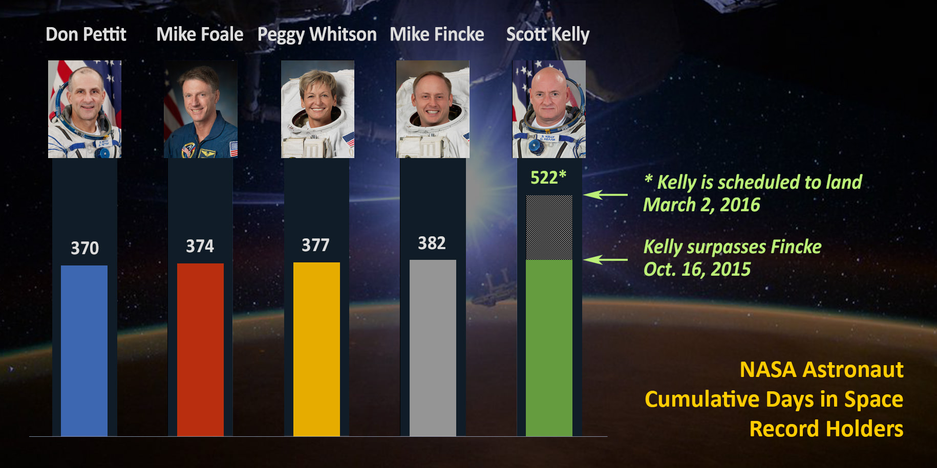
NASA astronaut Scott Kelly has just broken the American record for most time spent in space – at 383 days and counting – as part of his groundbreaking yearlong mission living aboard the International Space Station (ISS), where he currently serves as station commander.
See Kelly break the US spaceflight endurance record on the ISS at the “SPEED OF SOUND” in the beautifully space themed music video (above) set to the worldwide hit song by rock band Coldplay.
The video recounts a flurry of highlights from the yearlong space station mission with his partner, Russian cosmonaut Mikahail Kornienko, and the rest of the rotating cast of international crewmates.
On October 16, 2015, Kelly surpassed the US time in space record of 382 days previously held by NASA astronaut Mike Fincke.
The ‘1 Year ISS mission’ is aimed at conducting research to explore the impact of long term stays in space on the human body and aid NASA’s long term plans for a human ‘Journey to Mars’ in the 2030s.
“Records are meant to be broken. Look fwd to one of my colleagues surpassing my end 500+ days on our #JourneyToMars!’ Kelly tweeted from the ISS about his record breaking achievement.
As of today, October 20, Kelly has reached the 206 day mark aboard the ISS, of his planned 342 days in space. He’s now about a month past the half way mark.
In addition to his scientific research, Kelly has been a prolific photographer of all things space – including natural wonders and natural disasters like Hurricane Joaquin.
Here’s his newly released photo titled ‘Earth Art From Australia.’
‘Earth Art From Australia.’ @StationCDRKelly captured 17 pics from @Space_Station during a single flyover of Australia from 12/13 Oct 2015. Credit: NASA/Scott Kelly
See the NASA graphic herein showing the US astronauts who have accumulated the most spaceflight experience to date.
Station Commander Scott Kelly passed astronaut Mike Fincke, also a former station commander, on Oct. 16, 2015, for most cumulative days living and working in space by a NASA astronaut (383 days and counting). Kelly is scheduled to come home March 2, 2016, for a record total 522 days in space. Credit: NASA
Kelly accumulated his time in space during multiple spaceflights. Altogether this is his fourth mission and second long duration stay aboard the ISS. This flight also marks his second stint as station commander – as a member of the current Expedition 45 crew.
To be sure, Kelly is not merely passing Fincke’s record days but actually smashing through it by many months because he still has a long way to go until he returns home to Earth.
At the conclusion of his yearlong mission when he plummets back home in a Russian Soyuz capsule – along with Kornienko – on March 2, 2016, he will have compiled 522 total days living in space.
Kelly will also become the first American to spend a year in space, a feat previously achieved by only four Russian cosmonauts – all in the 1980s and 1990s aboard Russia’s Mir space station.
Next week on Thursday, Oct. 29, Kelly will break another American record for the single-longest spaceflight.
“On Oct. 29 on his 216th consecutive day in space, he will surpass astronaut Michael Lopez-Alegria’s record for the single-longest spaceflight by an American. Lopez-Alegria spent 215 days in space as commander of the Expedition 14 crew in 2006.”
Scott Kelly, U.S. astronaut and commander of the current Expedition 45 crew, broke the US record for time spent in space on Oct. 16, 2015. Credit: NASA
Kelly and Kornienko are spending a year aboard the ISS, “testing the limits of human research, space exploration and the human spirit,” says NASA officials.
The pair launched to the ISS in March 2015 along with Russian cosmonaut Gennady Padalka. He recently returned to Earth in September 2015 after setting the record for most time spent in space by any Earthling – with an accumulated total of 879 days living and working in space.
During their 342 days in space, Kelly and Kornienko are specifically “participating in studies in space that provide new insights into how the human body adjusts to weightlessness, isolation, radiation and stress of long-duration spaceflight. Kelly’s twin brother, former astronaut Mark Kelly, will participate in parallel twin studies on Earth to help scientists compare the effects on the body and mind in space.”
“The investigations in progress on the space station will help scientists better understand how to protect astronauts as they travel into deep space and eventually on missions to the Red Planet. The strong U.S.-Russian collaboration during the one-year mission is an example of the global cooperation aboard the space station that is a blueprint for international partnerships to advance shared goals in space exploration. Strengthening international partnerships will be key in taking humans deeper into the solar system,” according to NASA.
Hurricane Joaquin captured on Oct. 2, 2015 by NASA Astronaut Scott Kelly from the International Space Station. Credit: NASA/Scott Kelly
Kelly and the crew are also surely looking forward to the arrival of the Orbital ATK resupply ship carrying science experiments, provisions, spare parts, food and other goodies after it blasts off from Florida on Dec. 3 – detailed in my story here.
Stay tuned here for Ken’s continuing Earth and planetary science and human spaceflight news.
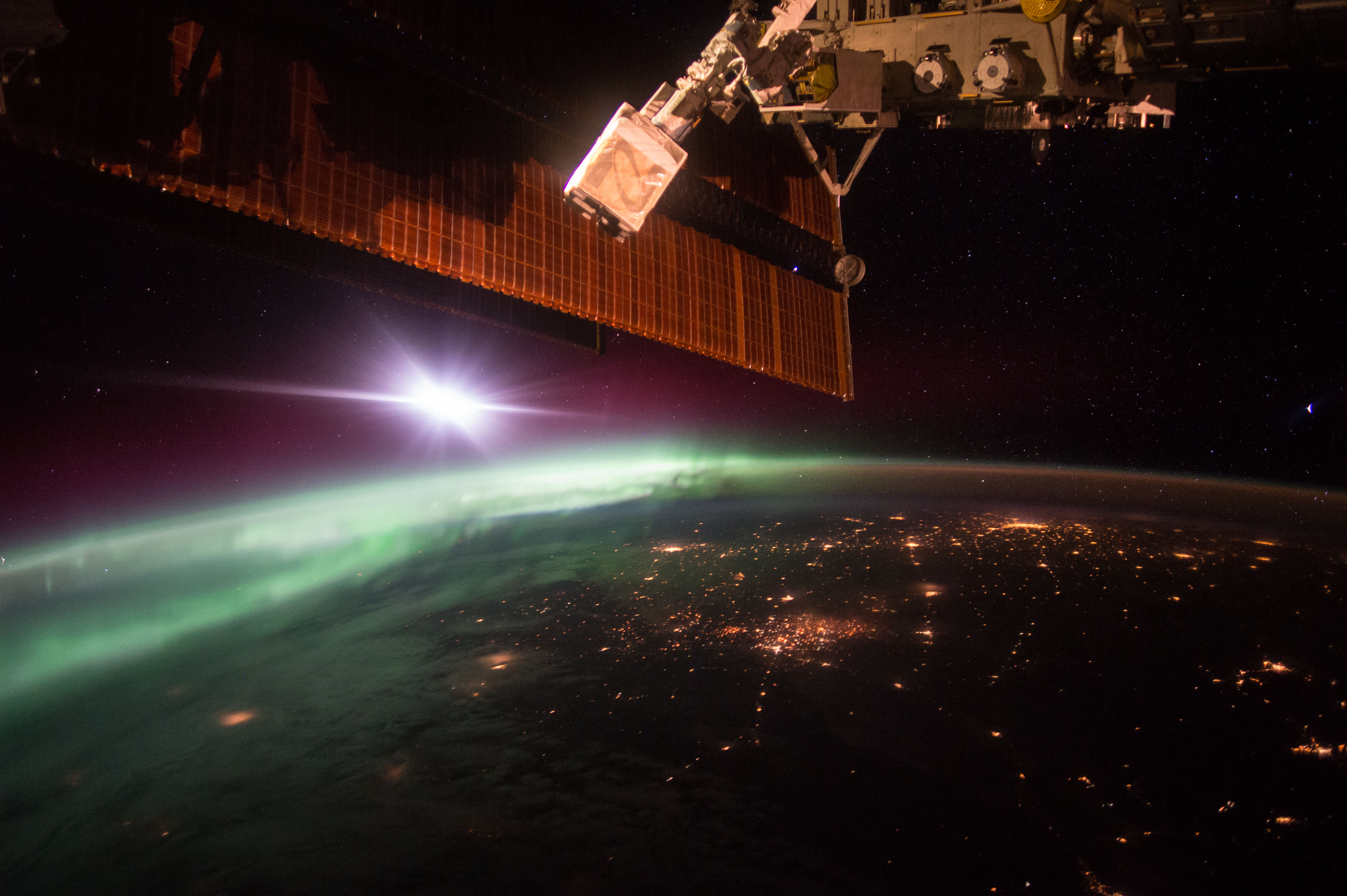
Ken Kremer Morning Aurora From the Space Station. NASA astronaut Scott Kelly (@StationCDRKelly) captured this photograph of the green lights of the aurora from the International Space Station on Oct. 7, 2015. Credit: NASA
NASA Astronaut Scott Kelly and Russian Cosmonaut Mikhail Kornienko comprise the first ever ISS 1 Year Crew
Earth rotates through an entire day as captured in this animation of 22 still images taken on Sept. 17, 2015 by NASA’s Earth Polychromatic Imaging Camera (EPIC) camera on the Deep Space Climate Observatory (DSCOVR) spacecraft. Credits: NASA
The EPIC camera, which stands for Earth Polychromatic Imaging Camera (EPIC), is located a million miles away on the DSCOVR real time space weather monitoring satellite and is designed to take full disk color images of the sunlit side of our home planet multiple times per day.
The EPIC NASA images are literally just a finger tip away, after a 17 year wait to get the satellite into the launch queue since it was first proposed by former VP Al Gore. They are all easily viewed at NASA’s new EPIC camera website which went online today, Monday, October 19, 2015.
This EPIC image was taken on Oct.17 and shows the Australian continent and a portion of Asia.
EPIC image taken on Oct. 17, 2015 showing the continent of Australia and a portion of Asia. Credit: NASA
An annotated guide map illustration identifying the visible land masses accompanies each EPIC image and follows along as the Earth rotates daily.
What a great geography learning tool for student classrooms worldwide!
Annotated guide map identifying the visible land masses accompanies each EPIC image. Credit: NASA
DSCOVR is a joint mission between NOAA, NASA, and the U.S Air Force (USAF) that is managed by NOAA. The satellite and science instruments were provided by NASA and NOAA.
EPIC is a four megapixel CCD camera and telescope mounted on DSCOVR and orbiting around the L1 Lagrange Point – a neutral gravity point that lies on the direct line between Earth and the sun.
NASA says that once per day they will post “at least a dozen new color images of Earth acquired from 12 to 36 hours earlier” taken by the agency’s EPIC camera. The EPIC images will be stored in an archive searchable by date and continent.
The image sequence will show “the Earth as it rotates, thus revealing the whole globe over the course of a day.”
“The effective resolution of the DSCOVR EPIC camera is somewhere between 6.2 and 9.4 miles (10 and 15 kilometers),” said Adam Szabo, DSCOVR project scientist at NASA’s Goddard Space Flight Center, Greenbelt, Maryland, in a statement.
“The color Earth images are created by combining three separate single-color images to create a photographic-quality image equivalent to a 12-megapixel camera. The camera takes a series of 10 images using different narrowband filters — from ultraviolet to near infrared — to produce a variety of science products. The red, green and blue channel images are used to create the color images. Each image is about 3 megabytes in size.”
EPIC will capture “a constant view of the fully illuminated Earth as it rotates, providing scientific observations of ozone, vegetation, cloud height and aerosols in the atmosphere.”
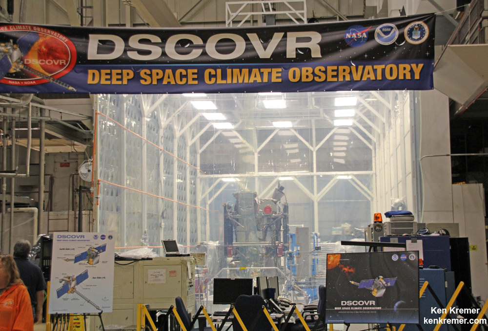
Technician works on NASA Earth science instruments and Earth imaging EPIC camera (white circle) housed on NOAA/NASA Deep Space Climate Observatory (DSCOVR) inside NASA Goddard Space Flight Center clean room in November 2014. Credit: Ken Kremer/kenkremer.com
The couch sized probe was launched atop a SpaceX Falcon 9 on Feb. 11, 2015 from Cape Canaveral, Florida, to start the million mile journey to its deep space observation post at L1. The rocket was funded by the USAF.
The primary goal of the $340 million DSCOVR satellite is to monitor the solar wind and aid very important forecasts of space weather at Earth from L1.
L1 is located 1.5 million kilometers (932,000 miles) sunward from Earth. At L1 the gravity between the sun and Earth is perfectly balanced and the DSCOVR satellite orbits about that spot just like a planet.
The mission is vital because its solar wind observations are crucial to maintaining accurate space weather forecasts to protect US infrastructure such as power grids, aviation, planes in flight, all types of Earth orbiting satellites for civilian and military needs, telecommunications, ISS astronauts and GPS systems.
This animation shows images of the far side of the moon, illuminated by the sun, as it crosses between the DISCOVR spacecraft’s Earth Polychromatic Imaging Camera (EPIC) camera and telescope, and the Earth – one million miles away. Credit: NASA/NOAA
DSCOVR was first proposed in 1998 by then US Vice President Al Gore as the low cost ‘Triana’ satellite to take near continuous views of the Earth’s entire globe to feed to the internet as a means of motivating students to study math and science.
It was also dubbed “Goresat.”
The probe was eventually resurrected and partially rebuilt at NASA Goddard Space Flight Center as a much more capable Earth science satellite that would also conduct the space weather observations.
But Triana was shelved for purely partisan political reasons and the satellite was placed into storage at NASA Goddard.
Thus the practical and teachable science and daily scenes of the gorgeously rotating Earth were lost – until now!
Former VP Al Gore was clearly delighted with today’s launch of NASA’s EPIC website in this pair of tweets:
“Today @NASA launched its site for #DSCOVR’s daily images. I look forward to seeing more from #DSCOVR,” tweeted Al Gore.
“DSCOVR’s site displaying new daily images of Earth from L1 was launched today! Congratulations to all those who made this happen!”
Stay tuned here for Ken’s continuing Earth and planetary science and human spaceflight news.
NOAA/NASA Deep Space Climate Observatory (DSCOVR) undergoes processing in NASA Goddard Space Flight Center clean room. Solar wind instruments at right. DSCOVER launched in February 2015 atop SpaceX Falcon 9 rocket. Credit: Ken Kremer/kenkremer.comNOAA/NASA/USAF Deep Space Climate Observatory (DSCOVR) undergoes processing in NASA Goddard Space Flight Center clean room. Probe launched in February 2015 atop SpaceX Falcon 9 rocket. Credit: Ken Kremer/kenkremer.com
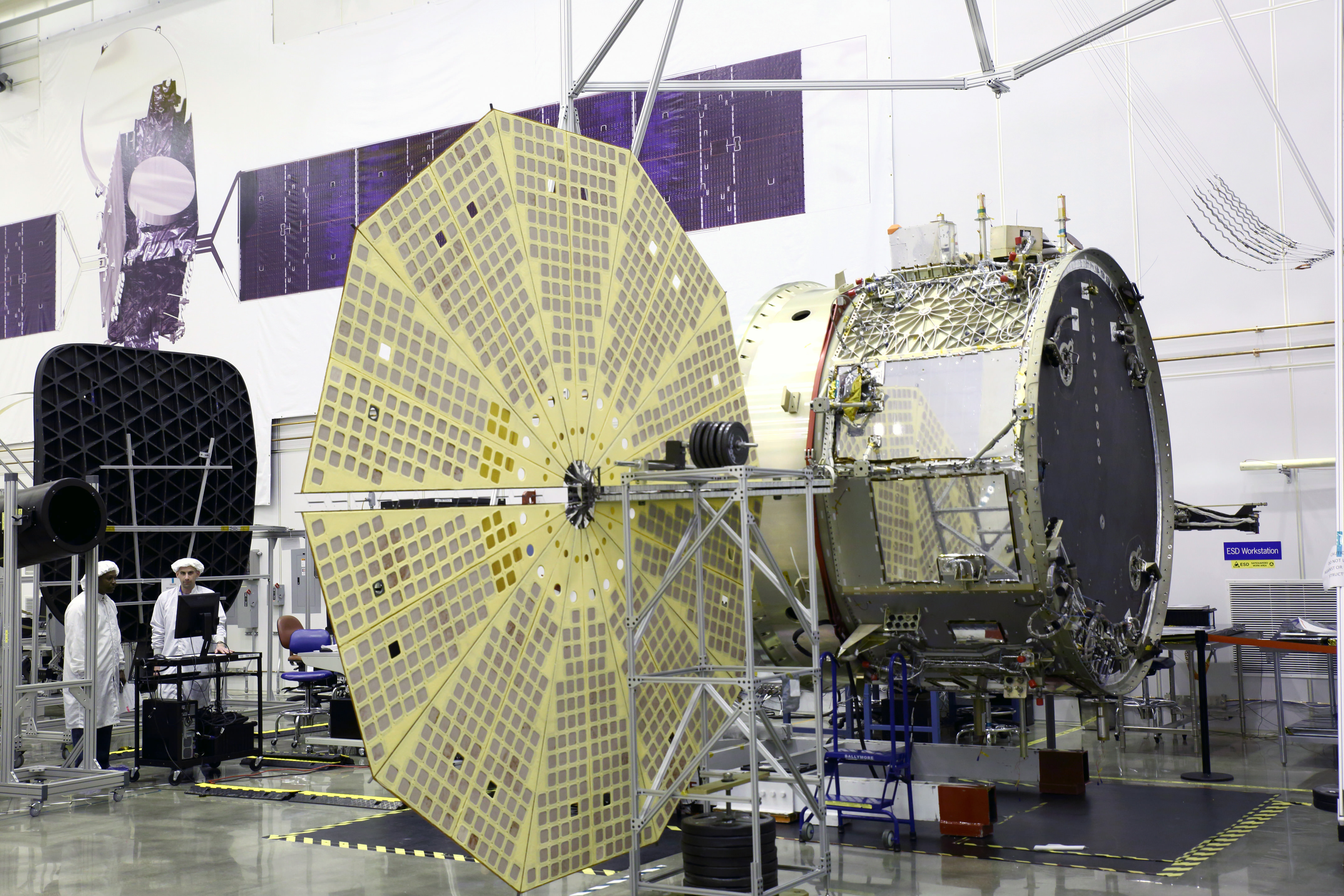
Cygnus service module built by Orbital ATK in their Dulles, Virginia cleanroom is shown here with unfurled Ultraflex solar panels that will fly for the first time with mated pressurized module on the OA-4 ISS resupply mission on ULA Atlas V rocket on Dec. 3, 2015 from Cape Canaveral, Florida. Credit: Orbital ATK
Cygnus service module built by Orbital ATK in their Dulles, Virginia cleanroom is shown here with unfurled UltraFlex solar panels that will fly for the first time with mated pressurized module on the OA-4 ISS resupply mission on ULA Atlas V rocket on Dec. 3, 2015 from Cape Canaveral, Florida. Credit: Orbital ATK
See OA-4 mission patch and hardware photos below
The biggest and heaviest Cygnus commercial cargo craft ever built by Orbital ATK is coming together at the Kennedy Space Center as the launch pace picks up steam for its critical ‘Return to Flight’ resupply mission to the space station for NASA. Cygnus is on target for an early December blastoff from Florida and the Orbital ATK team is “anxious to get flying again.”
Panoramic view from NASA’s Opportunity rover looking down the floor of Marathon Valley and out to the vast expense of Endeavour Crater. Marathon Valley holds significant deposits of water altered clay minerals. This composite photo mosaic shows the rover’s robotic arm reaching out at left to investigate Martian rocks holding clues to the planets watery past, and robot shadow and wheel tracks visible at right. The mosaic combines a flattened fisheye hazcam image at left with a trio of navcam camera images taken on Sol 4144 (Sept. 20, 2015) and colorized. Credit: NASA/JPL/Cornell/Ken Kremer/kenkremer.com/Marco Di Lorenzo
As NASA’s Opportunity rover approaches the 12th anniversary of landing on Mars, her greatest science discoveries yet are likely within grasp in the coming months since she has successfully entered Marathon Valley from atop a Martian mountain and is now prospecting downhill for outcrops of water altered clay minerals.
The valley is the gateway to alien terrain holding significant caches of the water altered minerals that formed under environmental conditions conducive to support Martian microbial life forms, if they ever existed. But as anyone who’s ever climbed down a steep hill knows, you have to be extra careful not to slip and slide and break something, no matter how beautiful the view is – Because no one can hear you scream on Mars! See the downward looking valley view above.
After a years long Martian mountain climbing and mountain top exploratory trek, Opportunity entered a notch named Marathon Valley from atop a breathtakingly scenic ridge overlook atop the western rim of Endeavour Crater.
Marathon Valley measures about 300 yards or meters long and cuts downhill through the west rim of Endeavour crater from west to east. Endeavour crater spans some 22 kilometers (14 miles) in diameter.
See our photo mosaics illustrating Opportunity’s view around and about Marathon Valley and Endeavour Crater, created by the image processing team of Ken Kremer and Marco Di Lorenzo.
Our mosaic above affords a downward looking view from Marathon Valley on Sol 4144, Sept. 20. It uniquely combines raw images from the hazcam and navcam cameras to gain a wider perspective panoramic view of the steep walled valley, and also shows the rover at work stretching out the robotic arm to potential clay mineral rock targets at left. Opportunity’s shadow and wheel tracks are visible at right.
Mosaic view from Opportunity rover looking along the high walls and down the floor of Marathon Valley with deposits of water altered clay minerals and out to the vast expense of Endeavour Crater. This navcam camera photo mosaic was assembled from images taken on Sol 4159 (Oct. 5, 2015) and colorized. Credit: NASA/JPL/Cornell/Marco Di Lorenzo/Ken Kremer/kenkremer.com
In late July, Opportunity began the decent into the valley from the western edge and started investigating scientifically interesting rock targets by conducting a month’s long “walkabout” survey ahead of the upcoming frigid Martian winter – the seventh since touchdown at Meridiani Planum in January 2004.
The walkabout was done to identify targets of interest for follow up scrutiny in and near the valley floor. Opportunity’s big sister Curiosity conducted a similarly themed “walkabout” at the base of Mount Sharp near her landing site located on the opposite side of the Red Planet.
“The valley is somewhat like a chute directed into the crater floor, which is a long ways below. So it is somewhat scary, but also pretty interesting scenery,” writes Larry Crumpler, a science team member from the New Mexico Museum of Natural History & Science, in a mission update.
“Its named Marathon Valley because the rover traveled one marathon’s distance to reach it,” Prof. Ray Arvidson, the rover Deputy Principal Investigator of Washington University told Universe Today.
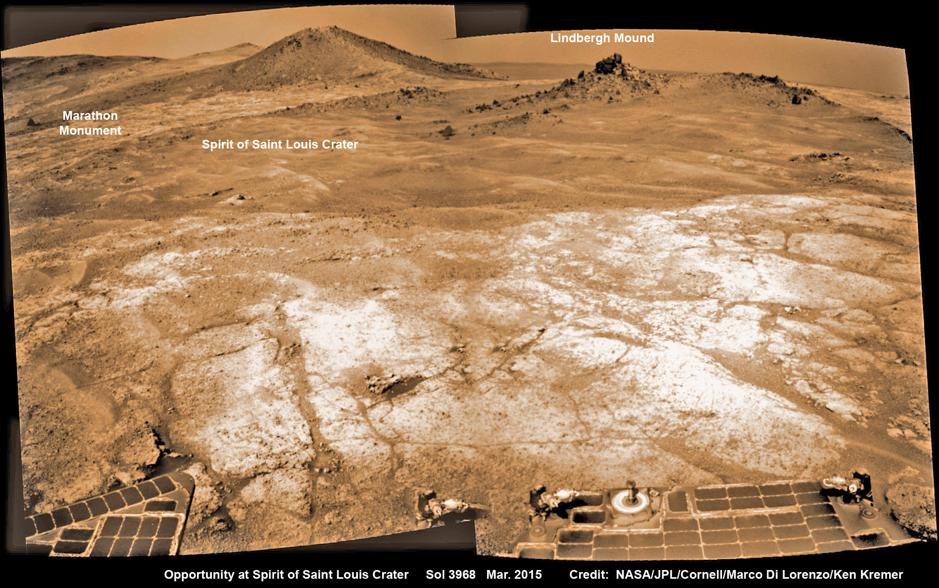
The NASA rover exceeded the distance of a marathon on the surface of Mars on March 24, 2015, Sol 3968. Opportunity has now driven over 26.46 miles (42.59 kilometers) over nearly a dozen Earth years.
Opportunity’s view (annotated) on the day the NASA rover exceeded the distance of a marathon on the surface of Mars on March 24, 2015, Sol 3968 with features named in honor of Charles Lindbergh’s historic solo flight across the Atlantic Ocean in 1927. Rover stands at Spirit of Saint Louis Crater near mountaintop at Marathon Valley overlook and Martian cliffs at Endeavour crater holding deposits of water altered clay minerals. This navcam camera photo mosaic was assembled from images taken on Sol 3968 (March 24, 2015) and colorized. Credit: NASA/JPL/Cornell/Marco Di Lorenzo/Ken Kremer/kenkremer.com
Now for the first time in history, a human emissary has arrived to conduct an up close inspection of and elucidate clues into this regions potential regarding Martian habitability.
The ancient, weathered slopes around Marathon Valley hold a motherlode of ‘phyllosilicate’ clay minerals, based on data obtained from the extensive Mars orbital measurements gathered by the CRISM spectrometer on NASA’s Mars Reconnaissance Orbiter (MRO) – accomplished earlier at the direction of Arvidson.
‘Hinners Point’ Above Floor of ‘Marathon Valley’ on Mars. This Martian scene shows contrasting textures and colors of “Hinners Point,” at the northern edge of “Marathon Valley,” and swirling reddish zones on the valley floor to the left. Credit: NASA/JPL-Caltech/Cornell Univ./Arizona State Univ.
Initially the science team was focused on investigating the northern region of the valley while the sun was still higher in the sky and generating more power for research activities from the life giving solar arrays.
“We have detective work to do in Marathon Valley for many months ahead,” said Opportunity Deputy Principal Investigator Ray Arvidson, of Washington University in St. Louis.
But now that the rover is descending into a narrow valley with high walls, the rovers engineering handlers back on Earth have to exercise added caution regarding exactly where they send the Opportunity on her science forays during each sols drive, in order to maintain daily communications.
The high walls to the north and west of the valley ridgeline has already caused several communications blackouts for the “low-elevation Ultra-High-Frequency (UHF) relay passes to the west,” according to the JPL team controlling the rover.
Indeed on two occasions in mid September – coinciding with the days just before and after our Sol 4144 (Sept. 20) photo mosaic view above, “no data were received as the orbiter’s flight path was below the elevation on the valley ridgeline.
On Sept 17 and Sept. 21 “the high ridgeline of the valley obscured the low-elevation pass” and little to no data were received. However the rover did gather imagery and spectroscopic measurements for later transmission.
Now that winter is approaching the rover is moving to the southern side of Marathon Valley to soak up more of the sun’s rays from the sun-facing slope and continue research activities.
“During the Martian late fall and winter seasons Opportunity will conduct its measurements and traverses on the southern side of the valley,” says Arvidson.
“When spring arrives the rover will return to the valley floor for detailed measurements of outcrops that may host the clay minerals.”
The shortest-daylight period of this seventh Martian winter for Opportunity will come in January 2016.
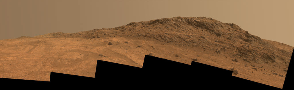
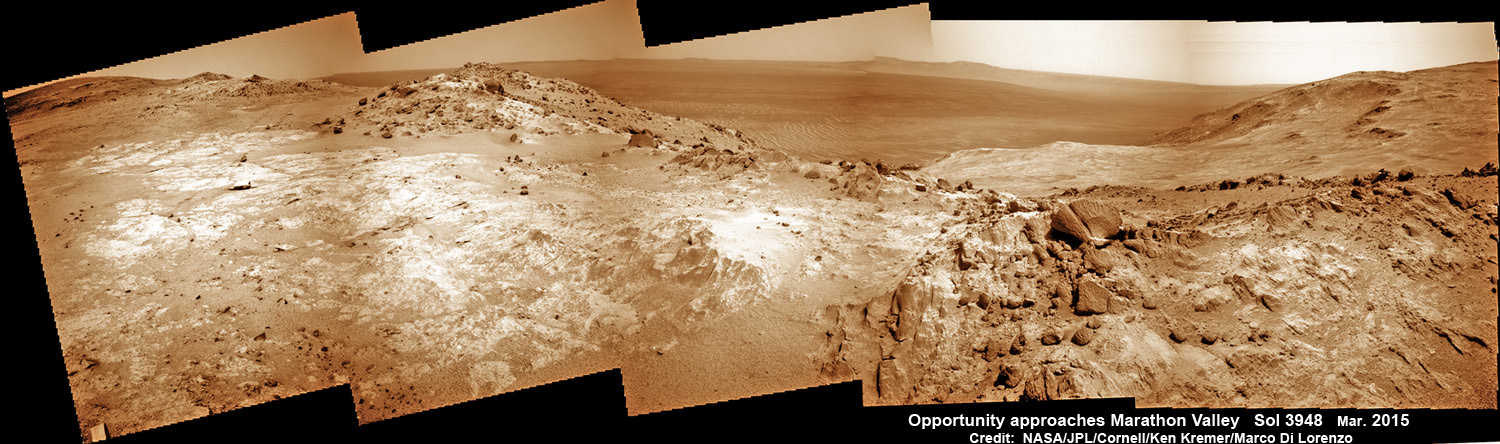
NASA’s Opportunity Rover scans along a spectacular overlook toward Marathon Valley on March 3, 2015, showing flat-faced rocks exhibiting a completely new composition from others examined earlier. Marathon Valley and Martian cliffs on Endeavour crater hold deposits of water altered clay minerals. This navcam camera photo mosaic was assembled from images taken on Sol 3948 (March 3, 2015) and colorized. Credit: NASA/JPL/Cornell/Ken Kremer/kenkremer.com/Marco Di Lorenzo
As of today, Sol 4168, Oct, 15, 2015 Opportunity has taken over 206,300 images and traversed over 26.46 miles (42.59 kilometers).
Stay tuned here for Ken’s continuing Earth and planetary science and human spaceflight news.
Nearly 12 Year Traverse Map for NASA’s Opportunity rover from 2004 to 2015
This map shows the entire path the rover has driven during almost 12 years and more than a marathon runners distance on Mars for over 4163 Sols, or Martian days, since landing inside Eagle Crater on Jan 24, 2004 – to current location at the western rim of Endeavour Crater and descending into Marathon Valley. Rover surpassed Marathon distance on Sol 3968 and marked 11th Martian anniversary on Sol 3911. Opportunity discovered clay minerals at Esperance – indicative of a habitable zone – and is currently searching for more at Marathon Valley. Credit: NASA/JPL/Cornell/ASU/Marco Di Lorenzo/Ken Kremer/kenkremer.com