This Galielo image shows Jupiter's moon Ganymede in enhanced colour. The JWST aimed its instruments at our Solar System's largest moon to study its surface. Credit: NASA
In 1610, Galileo Galilei looked up at the night sky through a telescope of his own design. Spotting Jupiter, he noted the presence of several “luminous objects” surrounding it, which he initially took for stars. In time, he would notice that these “stars” were orbiting the planet, and realized that they were in fact Jupiter’s moons – which would come to be named Io, Europa, Ganymede and Callisto.
Of these, Ganymede is the largest, and boasts many fascinating characteristics. In addition to being the largest moon in the Solar System, it is also larger than even the planet Mercury. It is the only satellite in the Solar System known to possess a magnetosphere, has a thin oxygen atmosphere, and (much like its fellow-moons, Europa and Callisto) is believed to have an interior ocean.
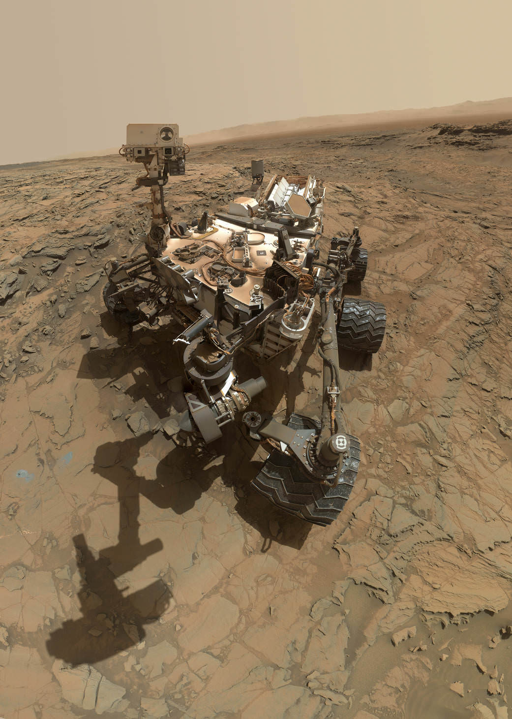
This self-portrait of NASA's Curiosity Mars rover shows the vehicle at the "Big Sky" site. Credit: NASA/JPL-Caltech/MSSS
This self-portrait of NASA’s Curiosity Mars rover shows the vehicle at the “Big Sky” site, where its drill collected the mission’s fifth taste of Mount Sharp, at lower left corner. The scene combines images taken by the Mars Hand Lens Imager (MAHLI) camera on Sol 1126 (Oct. 6, 2015). Credit: NASA/JPL-Caltech/MSSS
See below navcam drilling photo mosaic at Big Sky[/caption]
NASA’s Curiosity rover has managed to snap another gorgeous selfie while she was hard at work diligently completing her newest Martian sample drilling campaign – at the ‘Big Sky’ site at the base of Mount Sharp, the humongous mountain dominating the center of the mission’s Gale Crater landing site – which the science team just confirmed was home to a life bolstering ancient lake based on earlier sample analyses.
And the team is already actively planning for the car sized robots next drill campaign in the next few sols, or Martian days!
Overall ‘Big Sky’ marks Curiosity’s fifth ‘taste’ of Mount Sharp – since arriving at the mountain base one year ago – and eighth drilling operation since the nail biting Martian touchdown in August 2012.
NASA’s newly published self-portrait was stitched from dozens of images taken at Big Sky last week on Oct. 6, 2015, or Sol 1126, by the high resolution Mars Hand Lens Imager (MAHLI) color camera at the end of the rover’s 7 foot long robotic arm. The view is centered toward the west-northwest.
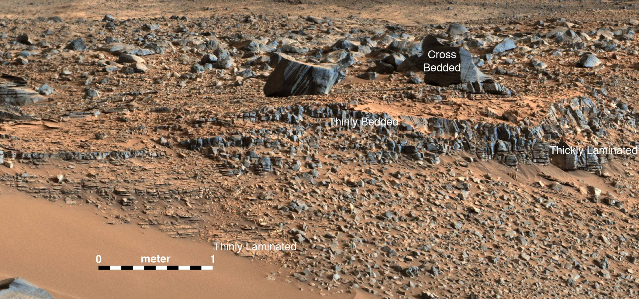
At Big Sky, the Curiosity Mars Science Laboratory (MSL) bored into an area of cross-bedded sandstone rock in the Stimson geological unit on Sept. 29, or Sol 1119. Stimson is located on the lower slopes of Mount Sharp inside Gale Crater.
NASA Curiosity rover reaches out with robotic arm to drill into cross-bedded sandstone rock at ‘Big Sky’ target on Sol 1119, Sept. 29, 2015, in this photo mosaic stitched from navcam camera raw images and colorized. Big Sky is located in the Stimson unit on the lower slopes of Mount Sharp inside Gale Crater. Credit: NASA/JPL/Ken Kremer/kenkremer.com/Marco Di Lorenzo
“Success! Our drill at “Big Sky” went perfectly!” wrote Ryan Anderson, a planetary scientist at the USGS Astrogeology Science Center and a member of the Curiosity ChemCam team.
The drill hole is seen at the lower left corner of the MAHLI camera selfie and appears grey along with grey colored tailing – in sharp contrast to the rust red surface. The hole itself is 0.63 inch (1.6 centimeters) in diameter.
Another panoramic view of the ‘Big Sky’ location shot from the rover’s eye perspective with the mast mounted Navcam camera, is shown in our photo mosaic view herein and created by the image processing team of Ken Kremer and Marco Di Lorenzo. The navcam mosaic was stitched from raw images taken up to Sol 1119 and colorized.
“With Big Sky, we found the ordinary sandstone rock we were looking for,” said Curiosity Project Scientist Ashwin Vasavada, in a statement.
The Big Sky drilling operation is part of a coordinated multi-step campaign to examine different types of sandstone rocks to provide geologic context.
“It also happens to be relatively near sandstone that looks as though it has been altered by fluids — likely groundwater with other dissolved chemicals. We are hoping to drill that rock next, compare the results, and understand what changes have taken place.”
Per normal operating procedures, the Big Sky sample was collected for analysis of the Martian rock’s ingredients in the rover’s two onboard laboratories – the Chemistry and Mineralogy X-Ray diffractometer (CheMin) and the Sample Analysis at Mars (SAM) instrument suite.
“We are all eagerly looking forward to the CheMin results from Big Sky to compare with our previous results from “Buckskin”! noted Anderson.
Curiosity extends robotic arm and conducts sample drilling at “Buckskin” rock target at bright toned “Lion” outcrop at the base of Mount Sharp on Mars, seen at right. Gale Crater eroded rim seen in the distant background at left, in this composite multisol mosaic of navcam raw images taken to Sol 1059, July 30, 2015. Navcam camera raw images stitched and colorized. Inset: MAHLI color camera up close image of full depth drill hole at “Buckskin” rock target on Sol 1060. Credit: NASA/JPL-Caltech/MSSS/Ken Kremer/kenkremer.com/Marco Di Lorenzo
This past weekend, Curiosity successfully fed pulverized and sieved samples of Big Sky to the inlet ports for both CheMin and SAM on the rover deck.
“The SAM analysis of the Big Sky drill sample went well and there is no need for another analysis, so the rest of the sample will be dumped out of CHIMRA on Sol 1132,” said Ken Herkenhoff, Research Geologist at the USGS Astrogeology Science Center and an MSL science team member, in a mission update.
Concurrently the team is hard at work readying the rover for the next drill campaign within days, likely at a target dubbed “Greenhorn.”
So the six wheeled rover drove about seven meters to get within range of Greenhorn.
With the sample deliveries accomplished, attention shifted to the next drilling campaign.
Today, Wednesday, Oct. 14, or Sol 1133, Curiosity was commanded “to dump the “Big Sky” sample and “thwack” CHIMRA (the Collection and Handling for in-Situ Martian Rock Analysis) to clean out any remnants of the sample,” wrote Lauren Edgar, a Research Geologist at the USGS Astrogeology Science Center and a member of MSL science team, in a mission update.
The ChemCam and Mastcam instruments are simultaneously making observations of the “Greenhorn” and “Gallatin Pass” targets “to assess chemical variations across a fracture.”
This Martian “postcard” comes after Mars Curiosity drilled its eighth hole on the Red Planet. This composite image looking toward the higher regions of Mount Sharp was taken on September 9, 2015, by NASA’s Curiosity rover. In the foreground — about 2 miles (3 kilometers) from the rover — is a long ridge teeming with hematite, an iron oxide. Credits: NASA/JPL-Caltech/MSSS
Curiosity has already accomplished her primary objective of discovering a habitable zone on the Red Planet – at the Yellowknife Bay area – that contains the minerals necessary to support microbial life in the ancient past when Mars was far wetter and warmer billions of years ago.
As of today, Sol 1133, October 14, 2015, she has driven some 6.9 miles (11.1 kilometers) kilometers and taken over 274,600 amazing images.
Stay tuned here for Ken’s continuing Earth and planetary science and human spaceflight news.
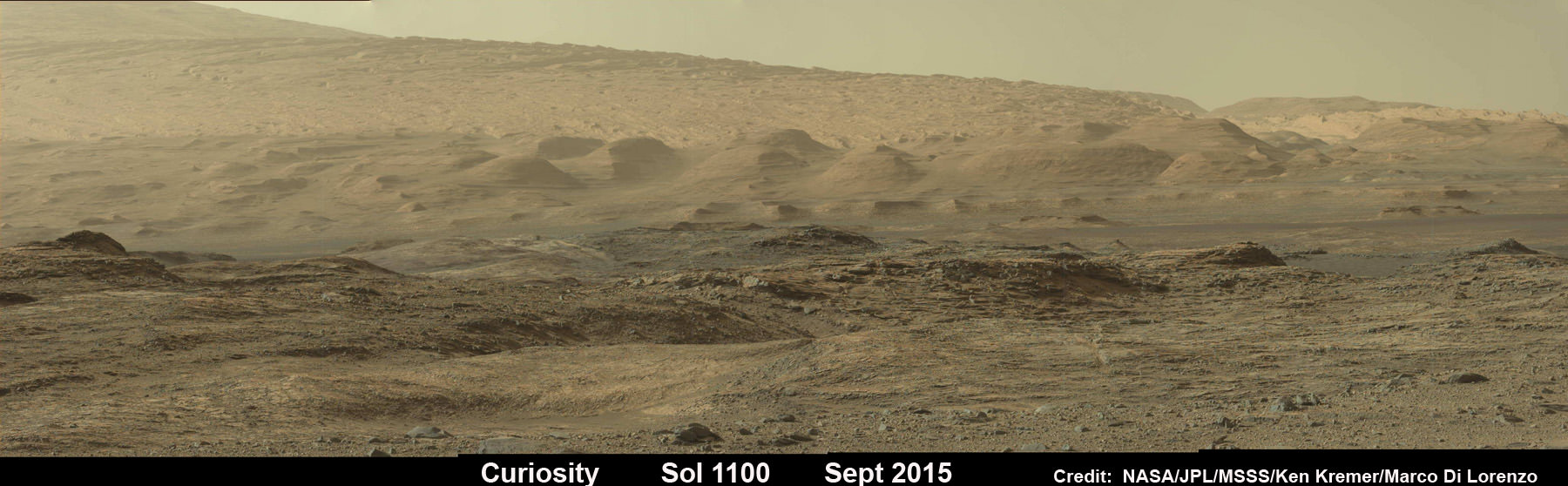
Curiosity looks toward fabulous canyons and buttes at the base of Mount Sharp from the Stimson sand dunes on Mars on Sol 1100, Sept. 10 2015 in this photo mosaic stitched from Mastcam color camera raw images. Credit: NASA/JPL/MSSS/Ken Kremer/kenkremer.com/Marco Di Lorenzo
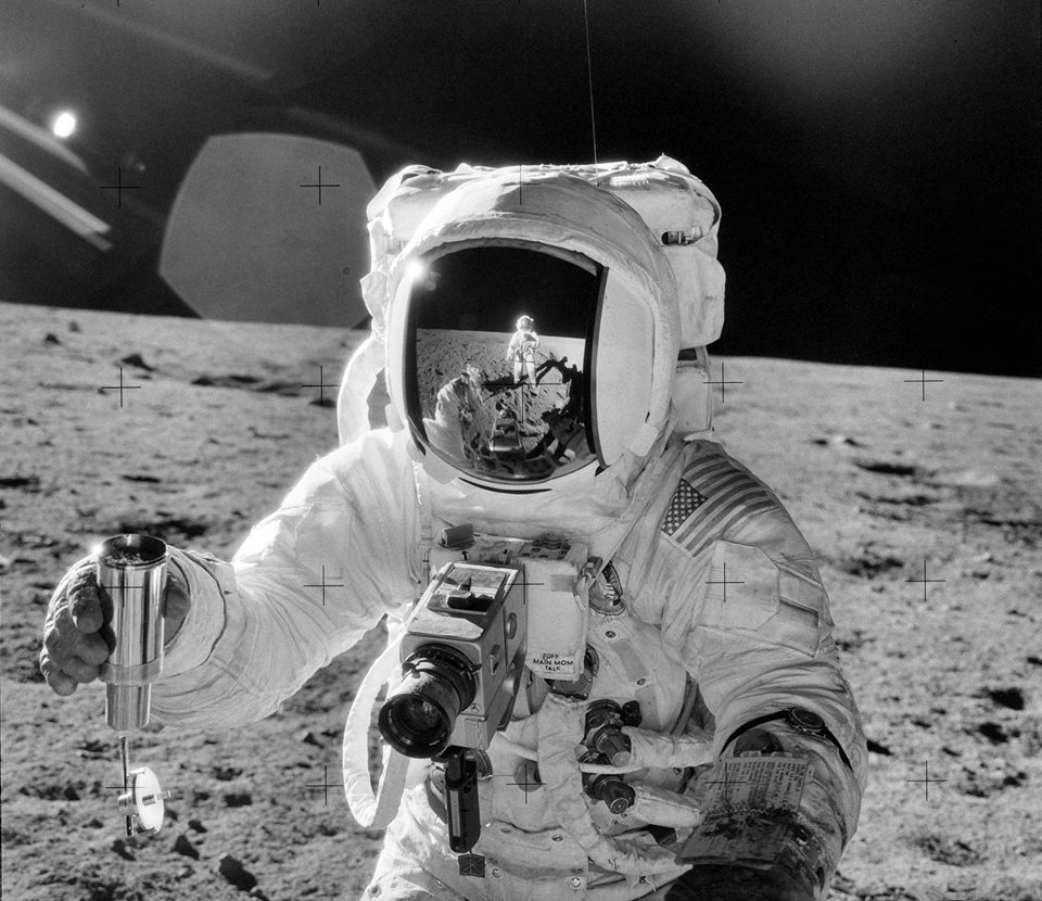
Astronaut Alan L. Bean holds a Special Environmental Sample Container filled with lunar soil collected during the second Apollo 12 extravehicular activity (EVA) conducted by astronauts Charles Conrad Jr., commander, and Bean, lunar module pilot. Conrad, who took this picture, is reflected in Bean's helmet visor. November 20, 1969. Credit: NASA/JSC.
When NASA recently posted over 8,000 images from the Apollo missions on Flickr, I just knew something good was going to happen! There are so many creative people out there that just need a little spark, a little inspiration and they’re off creating wonderful things. Three videos so far have surfaced based on the imagery from NASA’s Apollo Archive.
The first comes from Tom Kucy who posted his video titled “Ground Control” on You Tube and said this is a “small personal project, bringing NASA’s Apollo Archive photos to life.” This video is like a 2.5 minute mini-documentary of the Apollo missions. Kucy uses stunning photos and audio from the Apollo missions to create a truly stunning video. As one commenter said, “This happened prior to my birth, and I truly feel like I was there. Nice, nice work!”
Kucy also added that he has the intention of bringing more missions life, so stay tuned for more.
The second video was created by harrisonicus on Vimeo, who said he was looking through the Project Apollo Archive and “at one point, I began clicking through a series of pics quickly and it looked like stop motion animation. So, I decided to see what that would look like without me having to click through it.”
The third is a short gif video put together by planetary astronomer Alex Parker and posted on Twitter. He found new images of the damaged Apollo 13 Service Module, cleaned them up a bit and created this wonderful animation:
It’s a great new look at the service module, which was damaged when an oxygen tank in the module exploded. When the Apollo 13 crew jettisoned the crippled Service Module as they returned to Earth, they saw the extent of the damage from the explosion of the tank. “There’s one whole side of that spacecraft missing!” Jim Lovell radioed to Mission Control, his voice reflecting his incredulousness at seeing the damage of a 13-ft panel blown off the spacecraft.
Below are a few of our favorite images from the collection that we’ve found so far. Enjoy, and make sure you check out all the images for yourself!
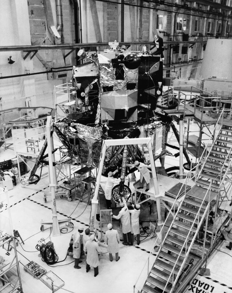
The Apollo 15 Saturn V Space Vehicle is seen from a camera located at the mobile launcher’s 360-foot level at Launch Pad 39A during venting of the liquid oxygen during the “wet” portion of the Countdown Demonstration Test on July 13, 1971. Credit: NASA/KSCThe Lunar Module for the Apollo 17 mission undergoes final checkout in the Manned Spacecraft Operations Building prior to mating to the Saturn V launch vehicle. November 3, 1972.
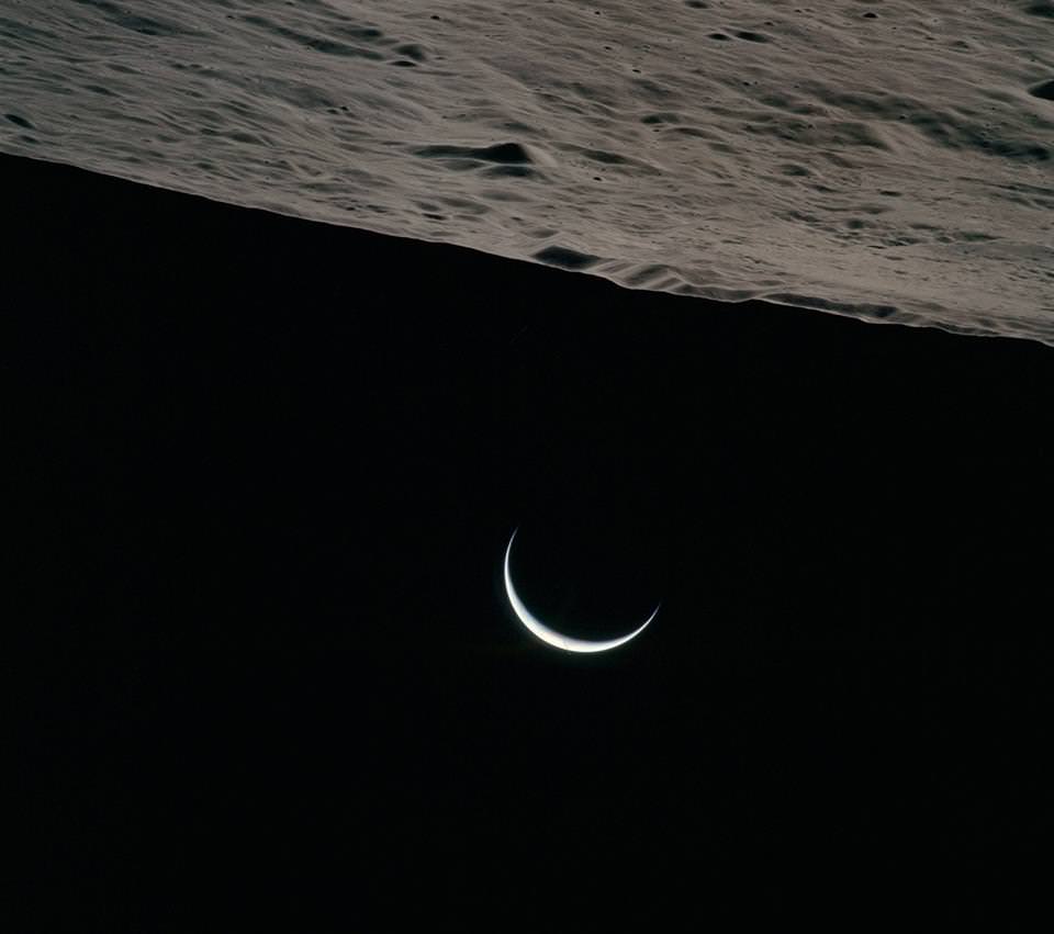
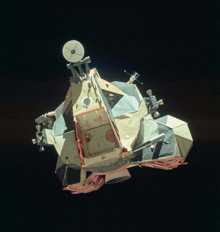
Credit: NASA.The Earth as photographed from the Apollo 4 mission, the first, unmanned test flight of the Saturn V, which reached an apogee of 18,092 kilometers. November 9, 1967. Credit: NASA.Crescent Earth as viewed by the crew of Apollo 15. Credit: NASA.The Apollo 17 Lunar Module “Challenger” ascent stage after returning from the lunar surface, photographed from the Command Module “America” prior to rendezvous. Credit: NASA/KSC.
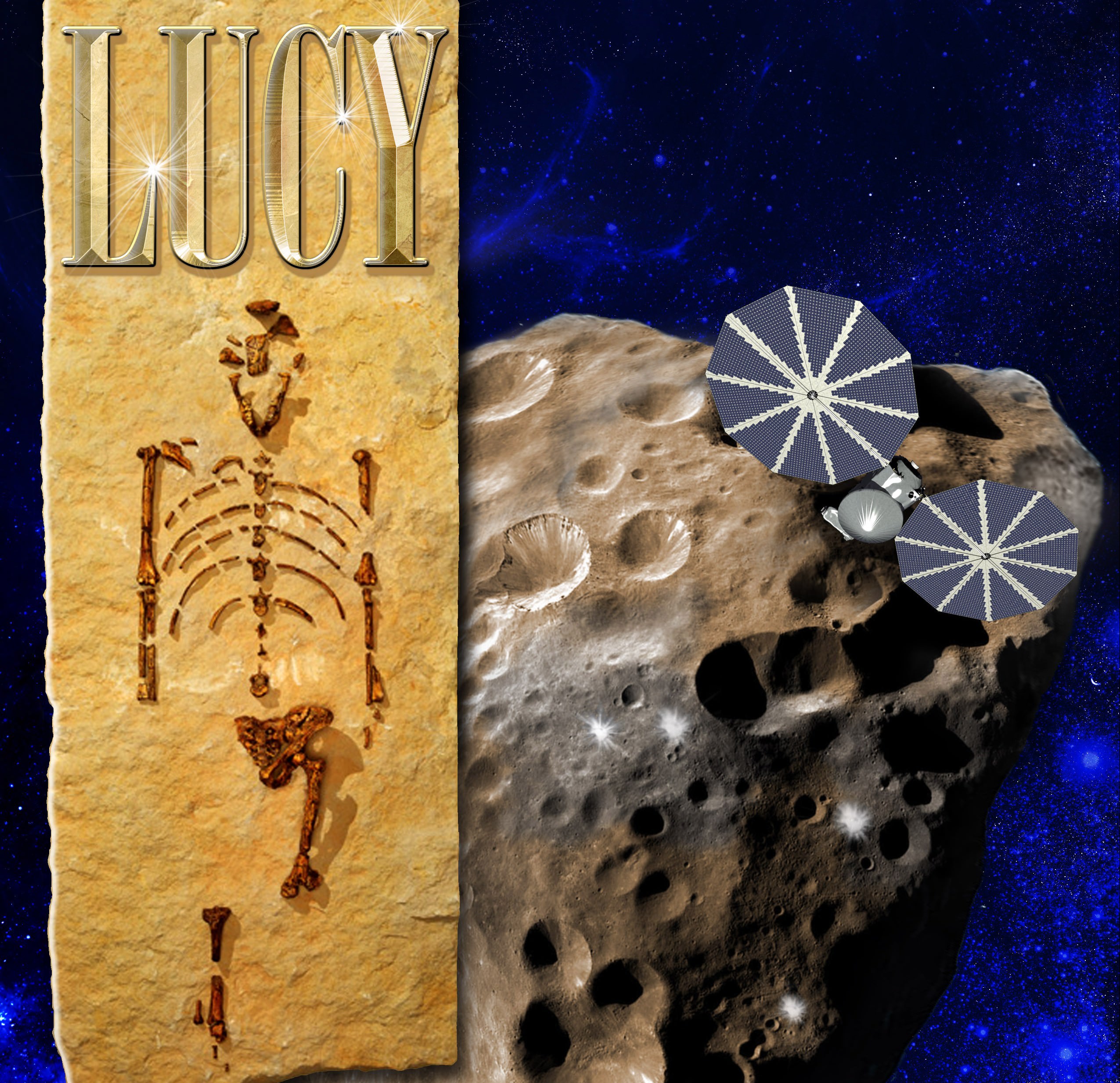
Lucy, an SwRI mission proposal to study primitive asteroids orbiting near Jupiter, is one of five science investigations under the NASA Discovery Program up for possible funding. Credit: swri.org
In February of 2014, NASA’s Discovery Program put out the call for mission proposals, one or two of which will have the honor of taking part in Discovery Mission Thirteen. Hoping to focus the next round of exploration efforts to places other than Mars, the five semifinalists (which were announced this past September) include proposed missions to Venus, Near-Earth Objects, and asteroids.
When it comes to asteroid exploration, one of the possible contenders is Lucy – a proposed reconnaissance orbiter that would study Jupiter‘s Trojan Asteroids. In addition to being the first mission of its kind, examining the Trojans Asteroids could also lead to several scientific finds that will help us to better understand the history of the Solar System.
By definition, Trojan are populations of asteroids that share their orbit with other planets or moons, but do not collide with it because they orbit in one of the two Lagrangian points of stability. The most significant population of Trojans in the Solar System are Jupiter’s, with a total of 6,178 having been found as of January 2015. In accordance with astronomical conventions, objects found in this population are named after mythical figures from the Trojan War.
There are two main theories as to where Jupiter’s Trojans came from. The first suggests that they formed in the same part of the Solar System as Jupiter and were caught by the gas giant’s gravity as it accumulated hydrogen and helium from the protoplanetary disk. Since they would have shared the same approximate orbit as the forming gas giant, they would have been caught in its gravity and orbited it ever since.
The asteroids of the Inner Solar System and Jupiter. Credit: Wikipedia Commons
The second theory, part of the Nice model, proposes that the Jupiter Trojans were captured about 500-600 million years after the Solar System’s formation. During this period Uranus, Neptune – and to a lesser extent, Saturn – moved outward, whereas Jupiter moved slightly inward. This migration could have destabilized the primordial Kuiper Belt, throwing millions of objects into the inner Solar System, some of which Jupiter then captured.
In either case, the presence of Trojan asteroids around Jupiter can be traced back to the early Solar System. Studying them therefore presents an opportunity to learn more about its history and formation. And if in fact the Trojans are migrant from the Kuiper Belt, it would also be a chance for scientists to learn more about the most distant reaches of the solar system without having to send a mission all the way out there.
The mission would be led by Harold Levison of the Southwest Research Institute (SwRI) in Boulder, Colorado, with the Goddard Space Center managing the project. Its targets would most likely include asteroid (3548) Eurybates, (21900) 1999 VQ10, (11351) 1997 TS25, and the binary (617) Patroclus/Menoetius. It would also visit a main-belt asteroid (1981 EQ5) on the way.
The spacecraft would perform scans of the asteroids and determine their geology, surface features, compositions, masses and densities using a sophisticated suite of remote-sensing and radio instruments. In addition, during it’s proposed 11-year mission, Lucy would also gather information on the asteroids thermal and other physical properties from close range.
Artist’s concept of Jupiter’s Trojan asteroids hovering in the foreground in Jupiter’s path, with the “Greeks” at left in the background. Credit: NASA.
The project is named Lucy in honor of one of the most influential human fossils found on Earth. Discovered in the Awash Valley of Ethiopia in 1974, Lucy’s remains – several hundred bone fragments that belonged to a member the hominid species of Australopithecus afarensis – proved to be an extraordinary find that advanced our knowledge of hominid species evolution.
Levison and his team are hoping that a similar find can be made using the probe of the same name. As he and his colleagues describe it, the Lucy mission is aimed at “Surveying the diversity of Trojan asteroids: The fossils of planet formation.”
“This is a once-in-a-lifetime opportunity,” said Levinson. “Because the Trojan asteroids are remnants of that primordial material, they hold vital clues to deciphering the history of the solar system. These asteroids are in an area that really is the last population of objects in the solar system to be visited.”
The payload is expected to include three complementary imaging and mapping instruments, including a color imaging and infrared mapping spectrometer, a high-resolution visible imager, and a thermal infrared spectrometer. NASA has also offered an additional $5 to $30 million in funding if mission planners choose to incorporate a laser communications system, a 3D woven heat shield, a Deep Space atomic clock, and/or ion engines.
As one of the semifinalists, the Lucy mission has received $3 million dollars to conduct concept design studies and analyses over the course of the next year. After a detailed review and evaluation of the concept studies, NASA will make the final selections by September 2016. In the end, one or two missions will receive the mission’s budget of $450 million (not including launch vehicle funding or post-launch operations) and will be launched by 2020 at the earliest.
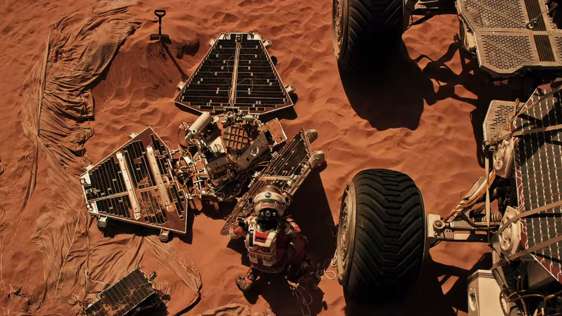
Scene from ‘The Martian’ starring Matt Damon as NASA astronaut Mark Watney contemplating magnificent panoramic vista while stranded alone on Mars. Credits: 20th Century Fox
Scene from ‘The Martian’ starring Matt Damon as NASA astronaut Mark Watney contemplating magnificent panoramic vista while stranded alone on Mars.
Credits: 20th Century Fox
See real Martian maps and flyover video from DLR and NSA below
Story/imagery updated[/caption]
Go now and experience Hollywood’s blockbuster new space epic ‘The Martian’ helmed by world renowned director Ridley Scott and starring Matt Damon as the protagonist, NASA astronaut Mark Watney. And you can follow Watney’s dramatic fictional path across the Red Planet in newly released real photos and a flyover video of the region, from DLR and NASA, as it looks today.
‘The Martian’ is a mesmerizingly enjoyable cinematic triumph for everyone that’s all about science, space exploration and one man’s struggle to survive while left totally isolated on the Red Planet in the face of seemingly insurmountable odds – relying on his wits alone to endure “on a planet where nothing grows” while hoping somehow for a rescue by NASA four years in the future.
The movie combines compelling and plausible storytelling with outstanding special effects that’s clearly delighting huge audiences worldwide with a positive and uplifting view of what could be achieved in the future – if only we really put our minds to it!
Based on the bestselling book by Andy Weir, ‘The Martian’ movie from 20th Century Fox tells the spellbinding story of how NASA astronaut Mark Watney is accidentally stranded on the surface of Mars during the future Ares 3 manned expedition in 2035, after a sudden and unexpectedly fierce dust storm forces the rest of the six person crew – commanded by Jessica Chastain as Commander Lewis – to quickly evacuate after they believe he is dead.
Real topographic map of the area of Mars covered in ‘The Martian.’ Follow the path of Mark Watney’s fictional endeavors from the Ares 3 landing site at Acidalia Planitia to NASA’s real Mars Pathfinder lander at the mouths of Ares Vallis and Tiu Valles and back, and finally to the Ares 4 landing site at Schiaparelli Crater. Credit: DLR/ESA/NASA
Now you can follow the fictional exploits of Mark Watney’s stunningly beautiful trail across the real Mars through a set of newly released maps, imagery and a 3D video created by the DLR, the German Aerospace Agency, and NASA – and based on photos taken by the European Space Agency’s Mars Express orbiter and NASA’s Mars Reconnaissance Orbiter (MRO).
DLR’s stunning 3D overflight video sequence was created from a dataset of 7300 stereo images covering roughly two-and-a-half million square kilometres of precisely mapped Martian landscape captured over the past 12 years by Mars Express High Resolution Stereo Camera (HRSC). The electric score is by Stephan Elgner.
Video Caption: Following the path of The Martian – video generated using images acquired by the Mars Express orbiter. Scientists from German Aerospace Center, DLR– who specialise in producing highly accurate topographical maps of Mars – reconstructed Watney’s route using stereo image data acquired by the High Resolution Stereo Camera on board European Space Agency’s #MarsExpress spacecraft. They then compiled this data into a video that shows the spectacular landscape that the protagonist would see ‘in the future’ on his trek from Ares 3 at Acidalia Planitia/Chryse Planitia to Ares 4 at Schiaparelli Crater. Credit: DLR/ESA
Ridley Scotts ‘The Martian’ takes place mostly on the surface of the Red Planet and is chock full of breathtakingly beautiful panoramic vistas. In the book you can only imagine Mars. In the movie Scott’s talents shine as he immerses you in all the action on the alien world of Mars from the opening scene.
Starting with the landing site for Watney’s Ares 3 mission crew at Acidalia Planitia, the book and movie follows his triumphs and tribulations, failures and successes as he logically solves one challenging problem after another – only to face increasingly daunting and unexpected hurdles as time goes by and supplies run low.
The DLR route map shows a real topographic view of Watney’s initial journey back and forth from the fictional Ares 3 landing site to the actual landing site of NASA’s 1997 Mars Pathfinder lander and Sojourner rover mission at the mouth of Ares Vallis.
Mark Watney arrives at the NASA’s 1997 Pathfinder lander to gather communications gear in a scene from “The Martian.” People and technology from NASA’s Jet Propulsion Laboratory aid fictional astronaut Mark Watney during his epic survival story in “The Martian.” Credits: 20th Century Fox
The map continues with Watney’s months-long epic trek to the fictional landing site of Ares 4 Mars Ascent Vehicle (MAV) spacecraft at Schiaparelli Crater, by way of Marth Valles and other Martian landmarks, craters and valleys.
At the request of Andy Weir, the HiRISE camera on NASA’s MRO orbiter took photos of the Martian plain at the Ares 3 landing site in Acidalia Planitia, which is within driving distance from the Pathfinder lander and Sojourner rover in the book and movie.
This May 2015 image from the HiRISE camera on NASA’s Mars Reconnaissance Orbiter shows a location on Mars associated with the best-selling novel and Hollywood movie, “The Martian.” It is in a region called Acidalia Planitia, at the landing site for the science-fiction tale’s Ares 3 mission. For the story’s central character, Acidalia Planitia is within driving distance from where NASA’s Mars Pathfinder, with its Sojourner rover, landed in 1997. Credits: NASA/JPL-Caltech/Univ. of Arizona
The Martian is all about how Watney uses his botany, chemistry and engineering skills to “Science the sh** out of it” to grow food and survive until the hoped for NASA rescue.
Learning how to live off the land will be a key hurdle towards enabling NASA’s real strategy for long term space voyages on a ‘Journey to Mars’ and back.
‘The Martian’ is a must see movie that broadly appeals to space enthusiasts and general audiences alike who can easily identify with Watney’s ingenuity and will to live.
Since its worldwide premiere on Oct. 2, ‘The Martian’ has skyrocketed to the top of the US box office for the second weekend in a row, hauling in some $37.3 million. The total domestic box office receipts now top $108 million and rockets to over $228 million worldwide in the first 10 days alone.
I absolutely loved ‘The Martian’ when I first saw the movie on opening weekend. And enjoyed it even more the second time, when I could pick up a few details I missed the first time around.
Matt Damon stars as NASA astronaut Mark Watney in ‘The Martian.’ Credit: 20th Century Fox
The movie begins as the crew evacuates after they believe Watney was killed by the dust storm. Watney actually survived the storm but lost contact with NASA. The film recounts his ingenious years long struggle to survive, figure out how to tell NASA he is alive and send a rescue crew before he starves to death on a planet where nothing grows. Watney’s predicament is a survival lesson to all including NASA.
‘The Martian’ was written by Andy Weir in 2010 and the film could well break the October movie box office record currently held by ‘Gravity.’
The movie closely follows the book, which I highly recommend you read at some point.
By necessity, the 2 hour 20 minute movie cannot capture every event in the book. So there is an abbreviated sense of Watney’s detailed science to survive and lengthy overland trips.
All the heroics and difficulties in traveling to Pathfinder and back and getting communications started, as well as the final month’s long journey to Schiaparelli crater are significantly condensed, but captured in spirit.
The Martian is brilliant and intelligent and rivals Stanley Kubrik’s space epic ‘2001: A Space Odyssey’ as one of the top movies about humanities space exploration quest.
The one big science inaccuracy takes place right at the start with the violent Martian dust storm.
On Mars the atmosphere is so thin that the winds would not be anywhere near as powerful or destructive as portrayed. This is acknowledged by Weir and done for dramatic license. We can look past that since the remainder of the tale portrays a rather realistic architectural path to Mars and vision of how scientists and engineers think. Plus the dust storms can in fact kick up tremendous amounts of particles that significantly block sunlight from impinging on solar energy generating panels.
Personally I can’t wait for the ‘Directors Cut’ with an added 30 to 60 minutes of scenes that were clearly filmed – but not included in the original theatrical release.
THE MARTIAN features a star studded cast that includes Matt Damon, Jessica Chastain, Kristen Wiig, Kate Mara, Michael Pena, Jeff Daniels, Chiwetel Ejiofor, and Donald Glover.
“NASA has endorsed “The Martian’” Jim Green, NASA’s Director of Planetary Sciences, told Universe Today. Green served as technical consultant on the film.
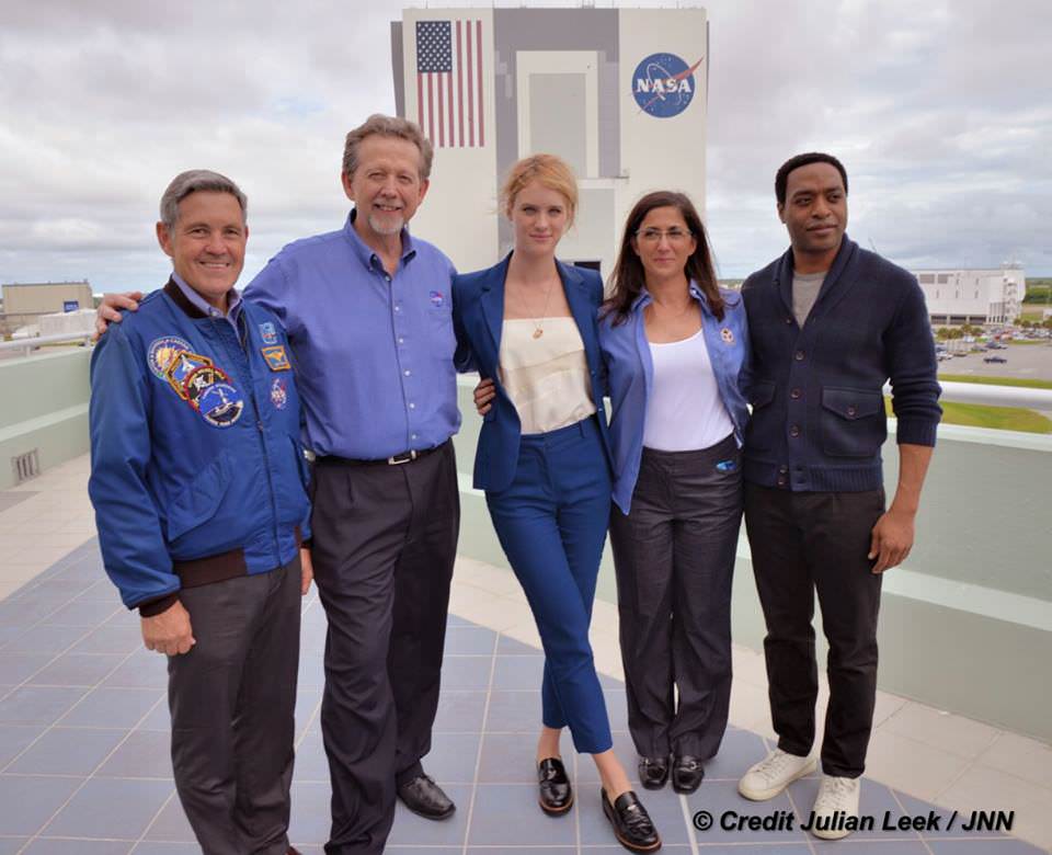
At NASA’s Kennedy Space Center in Florida agency scientists, astronauts actors from the 20th Century Fox Entertainment film “The Martian” met the media. Participants included, from the left, Center Director Bob Cabana, NASA’s Planetary Science Division Director Jim Green, Ph.D., actress Mackenzie Davis, who portrays Mindy Park in the movie, retired NASA astronaut Nicole Stott and actor Chiwetel Ejiofor, who portrays Vincent Kapoor in “The Martian.” Credit: Julian Leek
The DLR film was created by a team led by Ralf Jaumann from the DLR Institute of Planetary Research, Principal Investigator for HRSC. He believes that producing the overflight video was not just a gimmick for a science fiction film:
“Mars generates immense fascination, and our curiosity continues to grow! Many people are interested in our research, and young people in particular want to know what it is really like up there, and how realistic the idea that one day people will leave their footprints on the surface of Mars truly is. The data acquired by HRSC shows Mars with a clarity and detail unmatched by any other experiment. Only images acquired directly on the surface, for instance by rovers like Curiosity, are even closer to reality, but they can only show a small part of the planet. Thanks to this animation, we have even noticed a few new details that we had not seen in a larger spatial context. That is why we made the film – it helps everyone see what it would be like for Watney to travel through these areas… the clouds were the only creative touches we added, because, fortunately, they do not appear in the HRSC data,” according to a DLR statement.
Here’s the second official trailer for The Martian:
As a scientist and just plain Earthling, my most fervent hope is that ‘The Martian’ will inspire our young people to get interested in all fields of science, math and engineering and get motivated to become the next generation of explorers – here on Earth and beyond to the High Frontier to benefit all Mankind.
Stay tuned here for Ken’s continuing Earth and planetary science and human spaceflight news.
A view from the "Kimberley" formation on Mars taken by NASA's Curiosity rover. The strata in the foreground dip towards the base of Mount Sharp, indicating flow of water toward a basin that existed before the larger bulk of the mountain formed. This image was taken by the Mast Camera (Mastcam) on Curiosity on Sol 580 of the mission and has been “white balanced” to adjust for the lighting on Mars make the sky appear light blue. Credits: NASA/JPL-Caltech/MSSS
A view from the “Kimberley” formation on Mars taken by NASA’s Curiosity rover. The strata in the foreground dip towards the base of Mount Sharp, indicating flow of water toward a basin that existed before the larger bulk of the mountain formed. This image was taken by the Mast Camera (Mastcam) on Curiosity on Sol 580 of the mission and has been “white balanced” to adjust for the lighting on Mars make the sky appear light blue. Credits: NASA/JPL-Caltech/MSSS
Story/imagery updated[/caption]
Hot on the heels of NASA’s groundbreaking announcement on Sept. 28 of the discovery that “liquid water flows intermittently” across multiple spots on the surface of today’s Mars, scientists leading NASA’s Curiosity rover mission have confirmed that an ancient lake once filled the Gale Crater site which the robot has been methodically exploring since safely landing back in August 2012 near the base of a layered mountain known as Mount Sharp.
The new research finding from the Curiosity team was just published in the journal Science on Friday, Oct. 9, and boosts the chances that alien life may have taken hold in the form of past or present day Martian microbes.
The article is titled “Wet Paleoclimate of Mars Revealed by Ancient Lakes at Gale Crater,” with John Grotzinger, the former project scientist for the Mars Science Laboratory (MSL) mission at the California Institute of Technology in Pasadena, as lead author of the new report.
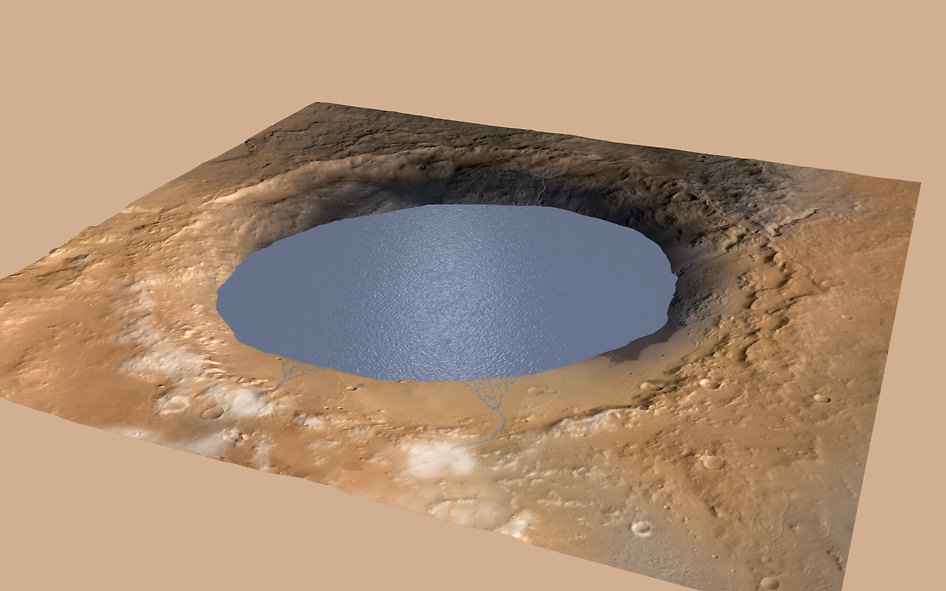
Simulated view of Gale Crater Lake on Mars. This illustration depicts a lake of water partially filling Mars’ Gale Crater, receiving runoff from snow melting on the crater’s northern rim. Credit: NASA/JPL-Caltech/ESA/DLR/FU Berlin/MSSS
The new study is coauthored by four dozen team members intimately involved in Curiosity’s ongoing exploits and “confirmed that Mars was once, billions of years ago, capable of storing water in lakes over an extended period of time.”
“Observations from the rover suggest that a series of long-lived streams and lakes existed at some point between about 3.8 to 3.3 billion years ago, delivering sediment that slowly built up the lower layers of Mount Sharp,” said Ashwin Vasavada, current MSL project scientist at NASA’s Jet Propulsion Laboratory in Pasadena, California, and co-author of the new report, in a statement.
Over the past three years, the Curiosity Mars Science Laboratory rover has been traversing the floor of Gale Crater investigating scores of different rocks and outcrops with her suite of state-of-the-art instruments, and painstakingly analyzing drill samples cored from their interiors with a pair of chemistry labs to elucidate the history of Mars based on NASA’s “follow the water” mantra.
The soundness of NASA Mars exploration strategy has repeatedly borne fruit and is now validated by overwhelming measurements gathered during Curiosity’s epic Martian trek confirming the existence of a lake where Mount Sharp now stands.
Exploring the sedimentary layers of Mount Sharp, which towers 3.4 miles (5.5 kilometers) into the Martian sky, is the primary destination and goal of the rovers long term scientific expedition on the Red Planet.
Since the nail biting touchdown on Aug. 5, 2012, Curiosity has been on a path towards the sedimentary layers at the lower reaches of Mount Sharp at the center of Gale Crater.
Curiosity rover panorama of Mount Sharp captured on June 6, 2014 (Sol 651) during traverse inside Gale Crater. Note rover wheel tracks at left. She will eventually ascend the mountain at the ‘Murray Buttes’ at right later this year. Assembled from Mastcam color camera raw images and stitched by Marco Di Lorenzo and Ken Kremer. Credit: NASA/JPL/MSSS/Marco Di Lorenzo/Ken Kremer-kenkremer.com
The car sized robot arrived at the foothills of Mount Sharp a year ago in September 2014, marking the start of the mountains formal investigation.
But the origin of Mount Sharp has been up for debate.
With the new data, researchers believe that the ancient lake helped fill Gale Crater with sediments deposited in layers over time that formed the foundation for Mount Sharp which now dominates the center of the crater.
“What we thought we knew about water on Mars is constantly being put to the test,” said Michael Meyer, lead scientist for NASA’s Mars Exploration Program at NASA Headquarters in Washington.
“It’s clear that the Mars of billions of years ago more closely resembled Earth than it does today. Our challenge is to figure out how this more clement Mars was even possible, and what happened to that wetter Mars.”
Mars was far wetter and warmer and possessed a much more massive atmosphere billions of years ago than it does today.
An image taken at the “Hidden Valley” site, en-route to Mount Sharp, by NASA’s Curiosity rover. A variety of mudstone strata in the area indicate a lakebed deposit, with river- and stream-related deposits nearby. This image was taken by the Mast Camera (Mastcam) on Curiosity on Sol 703. Credits: NASA/JPL-Caltech/MSSS
Gale Crater lake existed long before Mount Sharp ever formed during that period billions of years ago when the Red Planet was far warmer and wetter.
“Paradoxically, where there is a mountain today there was once a basin, and it was sometimes filled with water,” said Grotzinger, in a statement.
“We see evidence of about 250 feet (75 meters) of sedimentary fill, and based on mapping data from NASA’s Mars Reconnaissance Orbiter and images from Curiosity’s camera, it appears that the water-transported sedimentary deposition could have extended at least 500 to 650 feet (150 to 200) meters above the crater floor.”
Indeed there is additional evidence that the sedimentary deposits from interaction with water may be as thick as one-half mile (800 meters) above the crater floor. However beyond that there is no evidence of hydrated strata further up Mount Sharp.
But for reasons we are still trying to decipher and comprehend, Mars underwent radical climactic change between 3 and 4 billion years ago and was transformed from an ancient wet world, potentially hospitable to life, to a cold, dry desiccated world, rather inhospitable to life, that exists today.
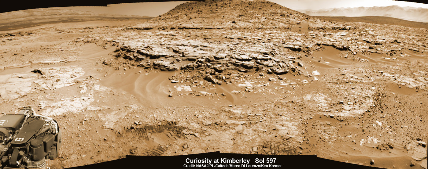
Curiosity’s Panoramic view of Mount Remarkable at ‘The Kimberley Waypoint’ where rover conducted 3rd drilling campaign inside Gale Crater on Mars. The navcam raw images were taken on Sol 603, April 17, 2014, stitched and colorized. Credit: NASA/JPL-Caltech/Ken Kremer – kenkremer.com/Marco Di Lorenzo. Featured on APOD – Astronomy Picture of the Day on May 7, 2014
Unlocking the mysteries, mechanisms and time periods of Mars climate change, loss of a thick atmosphere, ability to sustain liquid surface water and searching for organic compounds and for evidence of past or present habitable zones favorable to life are the questions driving NASA’s Mars Exploration program
Curiosity has already accomplished her primary objective of discovering a habitable zone on the Red Planet – at the Yellowknife Bay area – that contains the minerals necessary to support microbial life in the ancient past when Mars was far wetter and warmer billions of years ago.
NASA’s Curiosity rover looks back to ramp with potential 4th drill site target at ‘Bonanza King’ rock outcrop in ‘Hidden Valley’ in this photo mosaic view captured on Aug. 6, 2014, Sol 711. Inset shows results of brushing on Aug. 17, Sol 722, that revealed gray patch beneath red dust. Note the rover’s partial selfie, valley walls, deep wheel tracks in the sand dunes and distant rim of Gale crater beyond the ramp. Navcam camera raw images stitched and colorized. Credit: NASA/JPL-Caltech/Ken Kremer-kenkremer.com/Marco Di Lorenzo
“We have tended to think of Mars as being simple,” Grotzinger mused. “We once thought of the Earth as being simple too. But the more you look into it, questions come up because you’re beginning to fathom the real complexity of what we see on Mars. This is a good time to go back to reevaluate all our assumptions. Something is missing somewhere.”
As of today, Sol 1129, October 10, 2015, she has driven some 6.9 miles (11.1 kilometers) kilometers and taken over 274,000 amazing images.
Curiosity is at the vanguard of Earth’s fleet of seven robotic missions paving the path for NASA’s plans to send humans on a ‘Journey to Mars’ in the 2030s.
Stay tuned here for Ken’s continuing Earth and planetary science and human spaceflight news.
Curiosity Mars rover captured this panoramic view of a butte called “Mount Remarkable” and surrounding outcrops at “The Kimberley ” waypoint on April 11, 2014, Sol 597. Colorized navcam photomosaic was stitched by Marco Di Lorenzo and Ken Kremer. Credit: NASA/JPL-Caltech/Marco Di Lorenzo/Ken Kremer – kenkremer.com
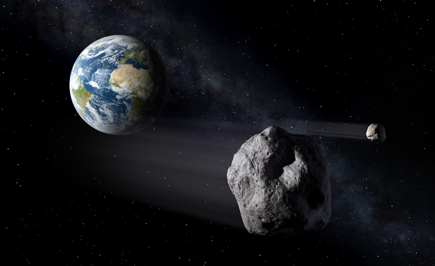
Artist's impression of a Near-Earth Asteroid passing by Earth. Credit: ESA
In February of 2014, NASA put out the call for submissions for the thirteenth mission of their Discovery Program. In keeping with the program’s goal of mounting low-cost, highly focused missions to explore the Solar System, the latest program is focused on missions that look beyond Mars to new research goals. On September 30th, 2015, five semifinalists were announced, which included proposals for sending probes back to Venus, to sending orbiters to study asteroids and Near-Earth Objects.
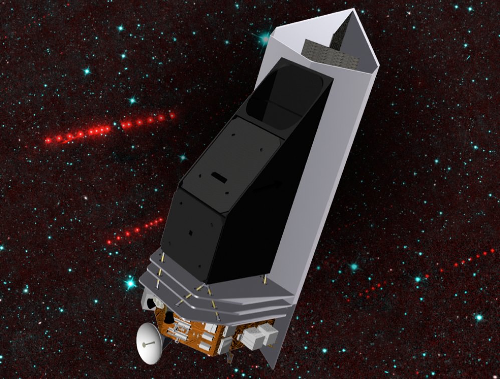
Among the proposed NEO missions is the Near Earth Object Camera, or NEOCam. Consisting of a space-based infrared telescope designed to survey the Solar System for potentially hazardous asteroids, the NEOCam would be responsible for discovering and characterizing ten times more near-Earth objects than all NEOs that have discovered to date.
If deployed, NEOCam will begin discovering approximately one million asteroids in the Main Belt and thousands of comets in the course of its 4 year mission. However, the primary scientific goal of NEOCam is to discover and characterize over two-thirds of the asteroids that are larger that 140 meters, since it is possible some of these might pose a threat to Earth someday.
Artist’s concept of the NEOCam spacecraft, a proposed mission for NASA’s Discovery program that would search for potentially hazardous near-Earth asteroids. Credit: NASA/JPL-Caltech
The technical term is Potentially Hazardous Objects (PHO), and it applies to near-Earth asteroids/comets that have an orbit that will allow them to make close approaches to Earth. And measuring more than 140 meters in diameter, they are of sufficient size that they could cause significant regional damage if they struck Earth.
In fact, a study conducted in 2010 through the Imperial College of London and Purdue University found that an asteroid measuring 50-meters across with a density of 2.6 grams per cubic centimeter and a speed of 12.7 kps could generate 2.9 Megatons of airburst energy once it passed through our atmosphere. To put that in perspective, that’s the equivalent of about nine W87 thermonuclear warheads!
By comparison, the meteor that appeared over the small Russian community of Chelyabinsk in 2013 measured only 20 meters across. Nevertheless, the explosive airbust caused by it entering our atmosphere generated only 500 kilotons of energy, creating a zone of destruction tens of kilometers wide and injuring 1,491 people. One can imagine without much effort how much worse it would have been had the explosion been six times as big!
What’s more, as of August 1st, 2015, NASA has listed a total of 1,605 potentially hazardous asteroids and 85 near-Earth comets. Among these, there are 154 PHAs believed to be larger than one kilometer in diameter. This represents a tenfold increase in discoveries since the end of the 1990s, which is due to several astronomical surveys being performed (as well as improvements in detection methods) over the past two and a half decades.
The NEOCam sensor (right) is the lynchpin for the proposed Near Earth Object Camera, or NEOCam, space mission (left). Credit: NASA/JPL-Caltech
As a result, monitoring and characterizing which of these objects is likely to pose a threat to Earth in the future has been a scientific priority in recent years. It is also why the U.S. Congress passed the “George E. Brown, Jr. Near-Earth Object Survey Act” in 2005. Also known as the “NASA Authorization Act of 2005”, this Act of Congress mandated that NASA identify 90% of all NEOs that could pose a threat to Earth.
If deployed, NEOCam will monitor NEOs from the Earth–Sun L1 Lagrange point, allowing it to look close to the Sun and see objects inside Earth’s orbit. To this, NEOCam will rely on a single scientific instrument: a 50 cm diameter telescope that operates at two heat-sensing infrared wavelengths, to detect the even the dark asteroids that are hardest to find.
By using two heat-sensitive infrared imaging channels, NEOCam can also make accurate measurements of NEO and gain valuable information about their sizes, composition, shapes, rotational states, and orbits. As Dr. Amy Mainzer, the Principal Investigator of the NEOCam mission, explained:
“Everyone wants to know about asteroids hitting the Earth; NEOCam is designed to tackle this issue. We expect that NEOCam will discover about ten times more asteroids than are currently known, plus millions of asteroids in the main belt between Mars and Jupiter. By conducting a comprehensive asteroid survey, NEOCam will address three needs: planetary defense, understanding the origins and evolution of our solar system, and finding new destinations for future exploration.”
Dr. Mainzer is no stranger to infrared imaging for the sake of space exploration. In addition to being the Principal Investigator on this mission and a member of the Jet Propulsion Laboratory, she is also the Deputy Project Scientist for the Wide-field Infrared Survey Explorer (WISE) and the Principal Investigator for the NEOWISE project to study minor planets.
She has also appeared many times on the History Channel series The Universe, the documentary featurette “Stellar Cartography: On Earth”, and serves as the science consultant and host for the live-action PBS Kids series Ready Jet Go!, which will be debuting in the winter of 2016. Under her direction, the NEOCam mission will also study the origin and ultimate fate of our solar system’s asteroids, and finding the most suitable NEO targets for future exploration by robots and humans.
Proposals for NEOCam have been submitted a total of three times to the NASA Discovery Program – in 2006, 2010, and 2015, respectively. In 2010, NEOCam was selected to receive technology development funding to design and test new detectors optimized for asteroid and comet detection and discovery. However, the mission was ultimately overruled in favor of the Mars InSight Lander, which is scheduled for launch in 2016.
As one of the semifinalists for Discovery Mission 13, the NEOCam mission has received $3 million for year-long studies to lay out detailed mission plans and reduce risks. In September of 2016, one or two finalist will be selected to receive the program’s budget of $450 million (minus the cost of a launch vehicle and mission operations), and will launch in 2020 at the earliest.
In related news, NASA has confirmed that the asteroid known as 86666 (2000 FL10) will be passing Earth tomorrow. No need to worry, though. At its closest approach, the asteroid will still be at a distance of 892,577 km (554,000 mi) from Earth. Still, every passing rock underlines the need for knowing more about NEOs and where they might be headed one day!
Pluto’s Blue Sky: Pluto’s haze layer shows its blue color in this picture taken by the New Horizons Ralph/Multispectral Visible Imaging Camera (MVIC). The high-altitude haze is thought to be similar in nature to that seen at Saturn’s moon Titan. The source of both hazes likely involves sunlight-initiated chemical reactions of nitrogen and methane, leading to relatively small, soot-like particles (called tholins) that grow as they settle toward the surface. Credits: NASA/JHUAPL/SwRI
With each passing day, significant discoveries about Pluto continue piling up higher and higher as more and more data gathered and stored from this past summer’s historic flyby by NASA’s New Horizons reaches ground stations back here on Earth.
“Blue skies–Pluto is awesome!” says Alan Stern, New Horizons principal investigator from Southwest Research Institute (SwRI), Boulder, Colorado.
The bluish tint to Pluto’s skies were unexpectedly discovered after researchers examined the first color images of the high altitude atmospheric hazes returned by New Horizons last week that were taken by the probes Ralph/Multispectral Visible Imaging Camera (MVIC).
“Who would have expected a blue sky in the Kuiper Belt?” Stern said in a NASA statement.
During New Horizons flyby on July 14, 2015, it discovered that Pluto is the biggest object in the outer solar system and thus the ‘King of the Kuiper Belt.”
The Kuiper Belt comprises the third and outermost region of worlds in our solar system.
“It’s gorgeous!” exclaims Stern.
Moreover, the source of Pluto’s blue haze is different from Earth’s and more related to Titan, Saturn’s largest moon – currently being explored by NASA’s Cassini mission orbiting Saturn since 2004.
On Earth, the blue sky is caused by light scattering off tiny particles of nitrogen molecules. Whereas on Titan its related to soot-like particles called tholins.
Tholins are generated by a series of very complex sunlight-initiated chemical reactions between nitrogen and methane (CH4) high in the atmosphere. This eventually produces relatively small, soot-like particles of complex hydrocarbons.
“That striking blue tint tells us about the size and composition of the haze particles,” said New Horizons science team researcher Carly Howett, of SwRI, in a statement.
“A blue sky often results from scattering of sunlight by very small particles. On Earth, those particles are very tiny nitrogen molecules. On Pluto they appear to be larger — but still relatively small — soot-like particles we call tholins.”
As the tholins rain down on Pluto, they add to the widespread red surface coloring.
The Ralph instrument was also key in another discovery announced by New Horizons researchers.
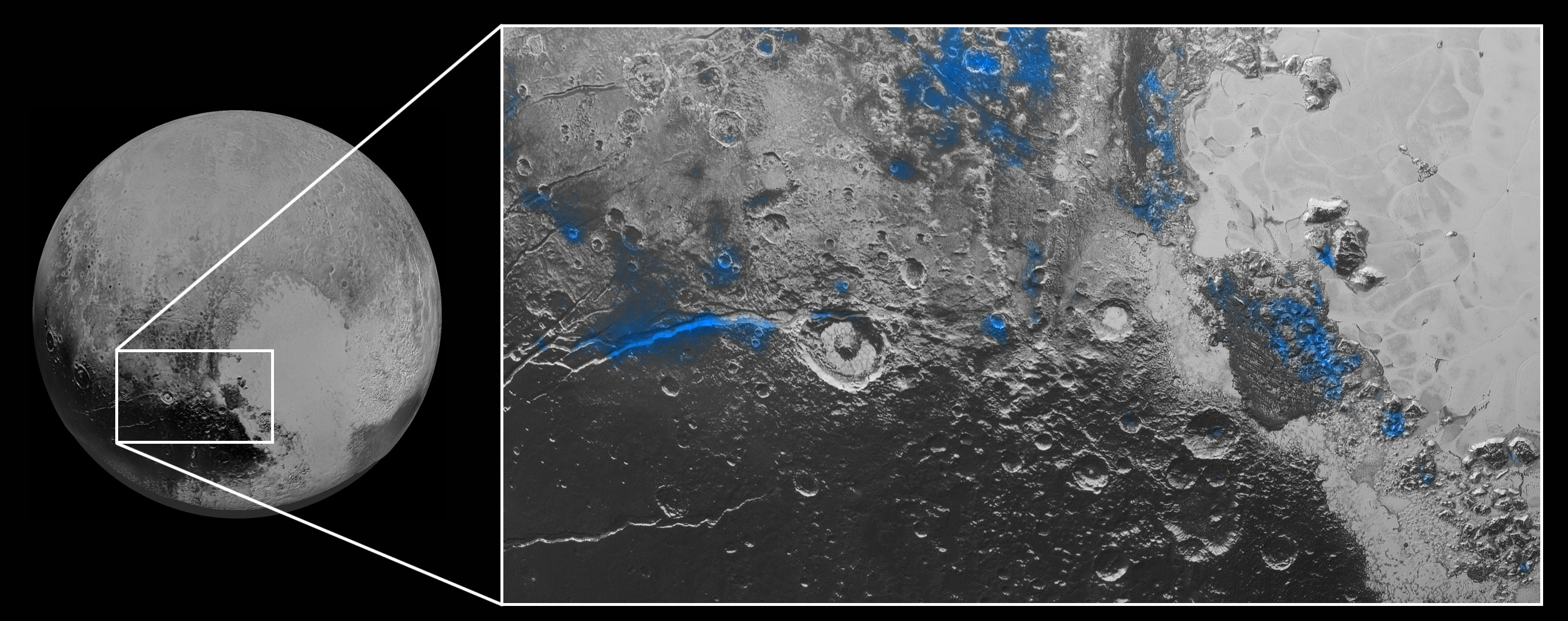
Numerous small, exposed regions of water ice on Pluto’s surface were discovered by combining measurements from the Ralph MVIC spectral composition mapper and infrared spectroscopy from the Linear Etalon Imaging Spectral Array (LEISA) instrument.
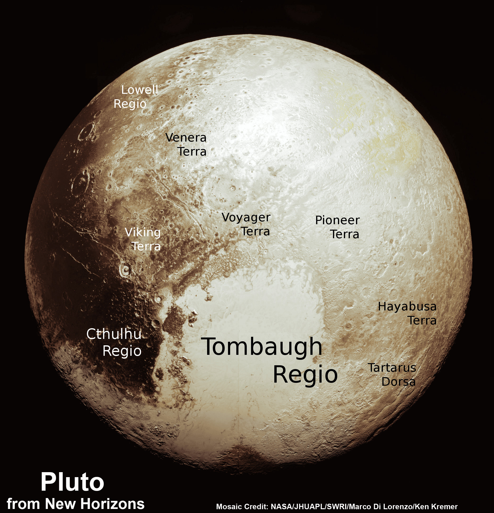
The strongest signatures of water ice were found in the Virgil Fossa and Viking Terra regions berby the western edge of Pluto’s huge heart-shaped Tombaugh Regio feature – see image below.
Water Ice on Pluto: Regions with exposed water ice are highlighted in blue in this composite image from New Horizons’ Ralph instrument, combining visible imagery from the Multispectral Visible Imaging Camera (MVIC) with infrared spectroscopy from the Linear Etalon Imaging Spectral Array (LEISA). The strongest signatures of water ice occur along Virgil Fossa, just west of Elliot crater on the left side of the inset image, and also in Viking Terra near the top of the frame. A major outcrop also occurs in Baré Montes towards the right of the image, along with numerous much smaller outcrops, mostly associated with impact craters and valleys between mountains. The scene is approximately 280 miles (450 kilometers) across. Note that all surface feature names are informal. Credits: NASA/JHUAPL/SwRI
Water ice is only found in certain zones of Pluto for reasons yet to be understood. There may also be a relationship to the tholins, that likewise is yet to be gleaned.
“I’m surprised that this water ice is so red,” says Silvia Protopapa, a science team member from the University of Maryland, College Park. “We don’t yet understand the relationship between water ice and the reddish tholin colorants on Pluto’s surface.”
This new global mosaic view of Pluto was created from the latest high-resolution images to be downlinked from NASA’s New Horizons spacecraft and released on Sept. 11, 2015. The images were taken as New Horizons flew past Pluto on July 14, 2015, from a distance of 50,000 miles (80,000 kilometers). This new mosaic was stitched from over two dozen raw images captured by the LORRI imager and colorized. Annotated with informal place names. Credits: NASA/Johns Hopkins University Applied Physics Laboratory/Southwest Research Institute/Marco Di Lorenzo/Ken Kremer/kenkremer.com
As of today, New Horizons remains healthy and is over 3.1 billion miles (5 billion kilometers) from Earth.
The team hopes to fire up the thrusters later this fall to propel the spacecraft toward a second Kuiper Belt Object (KBO) in 2019 tentativley named PT1, for Potential Target 1. It is much smaller than Pluto and was recently selected based on images taken by NASA’s Hubble Space Telescope.
Stay tuned here for Ken’s continuing Earth and planetary science and human spaceflight news.
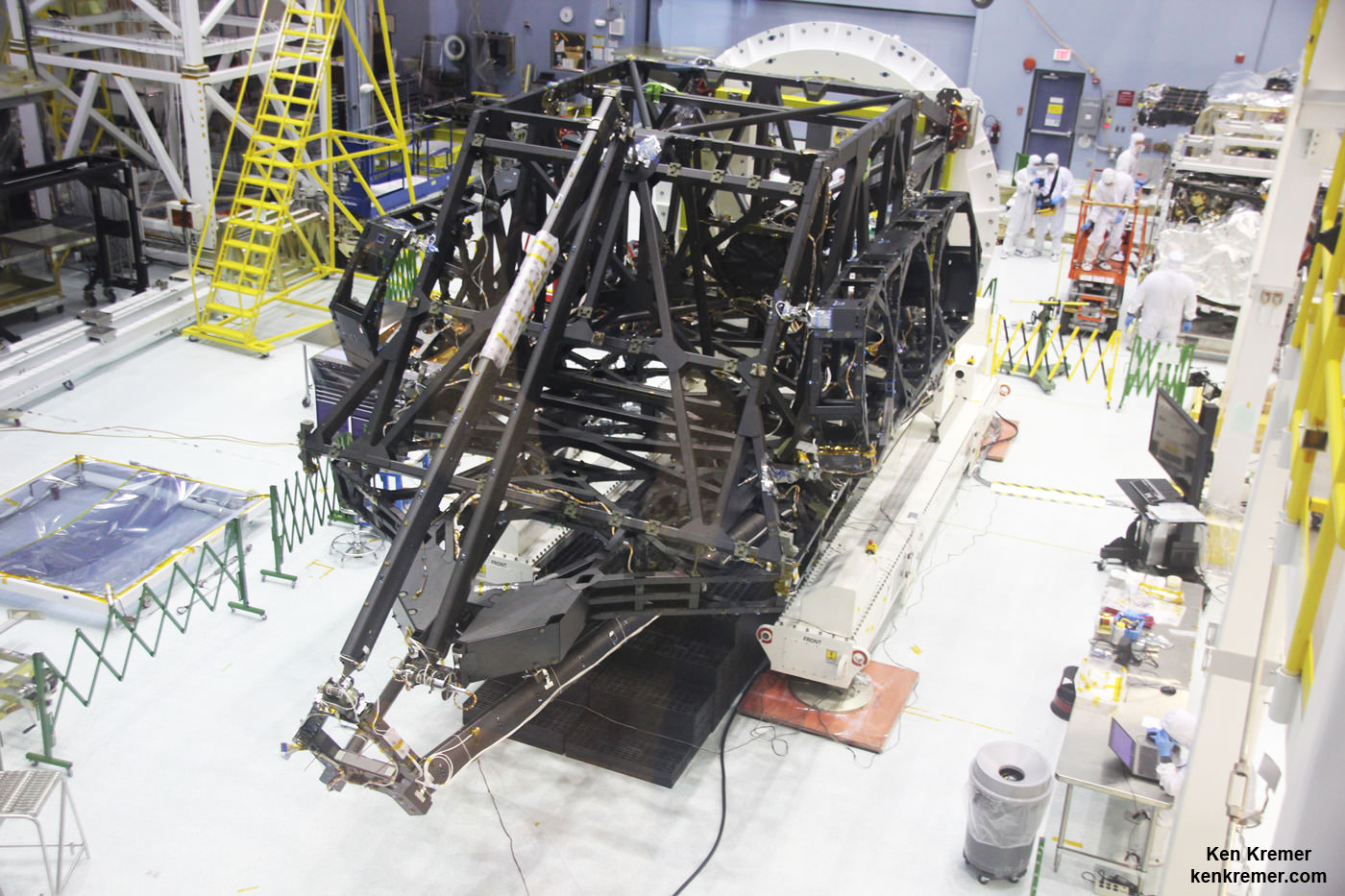
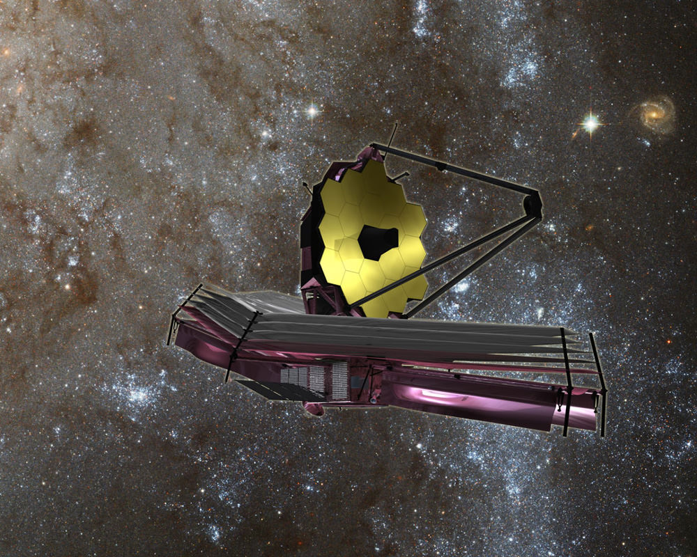
View showing actual flight structure of mirror backplane unit for NASA's James Webb Space Telescope (JWST) that holds 18 segment primary mirror array and secondary mirror mount at front, in stowed-for-launch configuration. JWST is being assembled here by technicians inside the world’s largest cleanroom at NASA Goddard Space Flight Center, Greenbelt, Md. Credit: Ken Kremer/kenkremer.com
View showing actual flight structure of mirror backplane unit for NASA’s James Webb Space Telescope (JWST) that holds 18 segment primary mirror array and secondary mirror mount at front, in stowed-for-launch configuration. JWST is being assembled here by technicians inside the world’s largest cleanroom at NASA Goddard Space Flight Center, Greenbelt, Md. Credit: Ken Kremer/kenkremer.com
Story/imagery updated[/caption]
NASA GODDARD SPACE FLIGHT CENTER, MD – The construction pace for NASA’s James Webb Space Telescope (JWST) took a major leap forward with delivery of the actual flight structure that serves as the observatory’s critical mirror holding backbone – to NASA’s Goddard Space Flight Center in Greenbelt, Maryland and observed by Universe Today.
“We are in good shape with the James Webb Space Telescope,” said Dr. John Mather, NASA’s Nobel Prize Winning scientist, in an exclusive interview with Universe Today at NASA Goddard during a visit to the flight structure – shown in my photos herein. Note: Read an Italian language version of this story – here at Alive Universe
And the mammoth $8.6 Billion Webb telescope has mammoth scientific objectives as the scientific successor to NASA’s Hubble Space Telescope (HST) – now celebrating its 25th anniversary in Earth orbit.
“JWST has the capability to look back towards the very first objects that formed after the Big Bang,” Mather told Universe Today.
How is that possible?
“James Webb has a much bigger mirror than Hubble. So its resolution is much better,” said astronaut and NASA science chief John Grunsfeld, during an exclusive interview at NASA Goddard. Grunsfeld flew on a trio of Hubble servicing missions aboard the Space Shuttle, including the final one during STS-125 in 2009.
“JWST can look back further in time, and a greater distance than Hubble, so we can see those first stars and galaxies formed in the Universe.”
These discoveries are only possible with Webb, which will become the most powerful telescope ever sent to space when it launches in 2018.
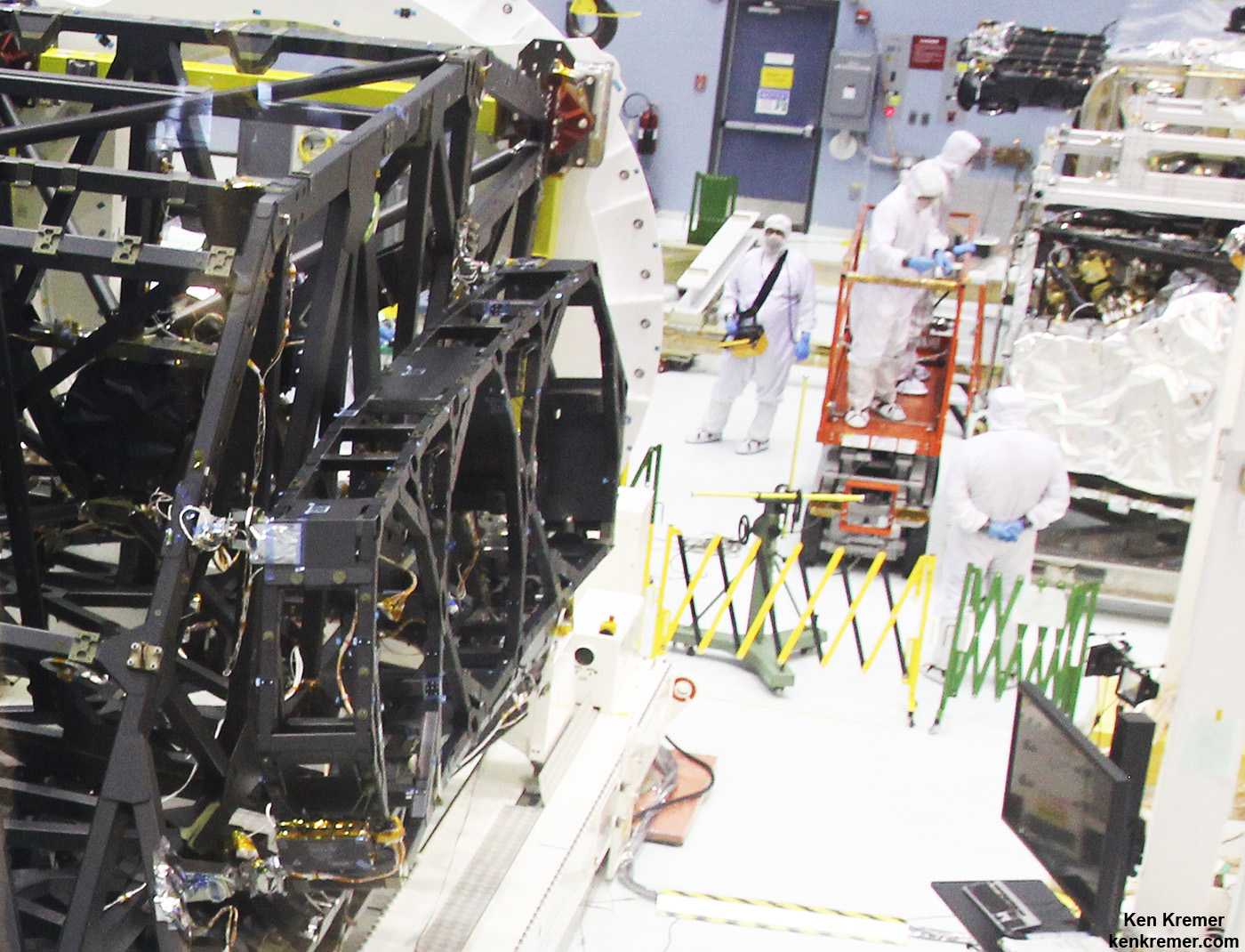
Up close view of actual side wing backplane of NASA’s James Webb Space Telescope (JWST) that will hold 3 of the observatory’s 18 primary mirrors, as technicians work inside cleanroom at NASA Goddard Space Flight Center, Greenbelt, Md. Credit: Ken Kremer/kenkremer.com
The massive JWST flight structure unit includes the “backplane assembly” that clasps in place all of the telescopes primary and secondary mirrors, as well as its ISIM science module loaded with the observatory’s quartet of state-of-the-art research instruments.
“The backplane looks really great,” Grunsfeld told me.
Numerous NASA centers and aerospace companies are involved in building the observatory and its backplane structure holding the mirrors that will search back some 13.4 billion years.
“The backplane structure just arrived in late August from Northrop Grumman Aerospace Systems in Redondo Beach, California,” said Sandra Irish, JWST lead structural engineer during an interview with Universe Today at the NASA Goddard cleanroom facility.
“This is the actual flight hardware.”
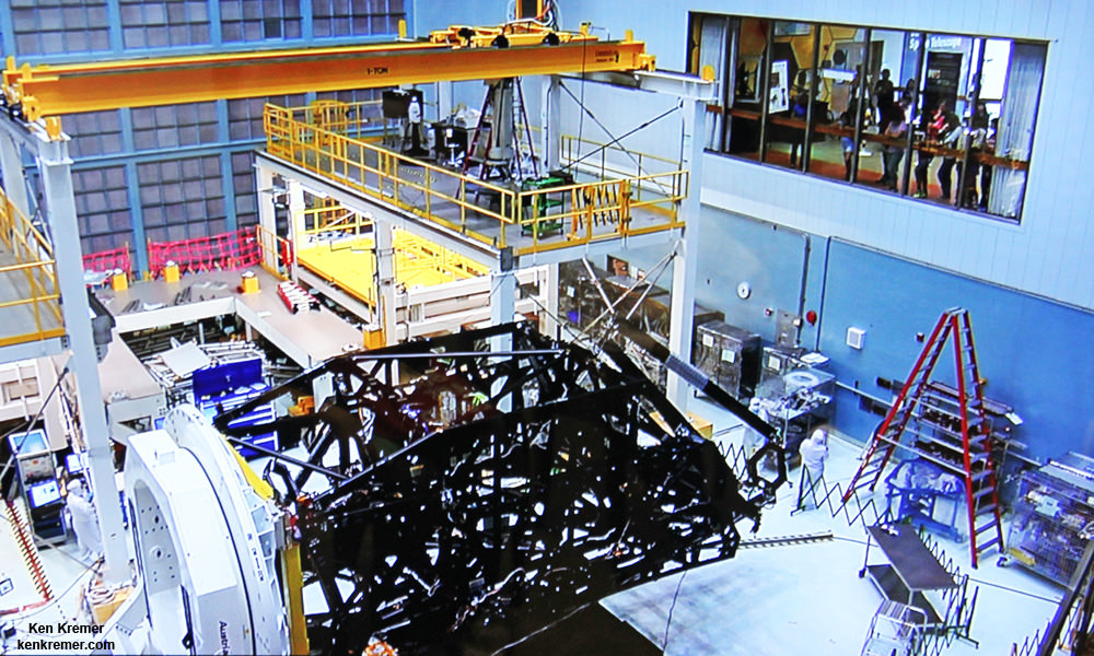
Side view of flight unit mirror backplane assembly structure for NASA’s James Webb Space Telescope (JWST) that holds primary mirror array and secondary mirror mount in stowed-for-launch configuration. JWST is being assembled technicians inside the cleanroom at NASA Goddard Space Flight Center, Greenbelt, Md. Credit: Ken Kremer/kenkremer.com
The purpose of JWST’s backplane assembly is to hold the telescopes 18 segment, 21-foot (6.5-meter) diameter primary mirror nearly motionless while floating in the utterly frigid space environment, thereby enabling the observatory to peer out into deep space for precise science gathering measurements never before possible.
The massive telescope structure “includes the primary mirror backplane assembly; the main backplane support fixture; and the deployable tower structure that lifts the telescope off of the spacecraft. The three arms at the top come together into a ring where the secondary mirror will reside,” say officials.
The backplane traveled a long and winding road before arriving at Goddard.
“The backplane structure was designed and built at Orbital ATK with NASA oversight,” Irish explained. The assembly work was done at the firms facilities in Magna, Utah.
“Then it was sent to Northrop Grumman in Redondo Beach, California for static testing. Then it came here to Goddard. Orbital ATK also built the composite tubes for the ISIM science module structure.”
The observatory’s complete flight structure measures about 26 feet (nearly 8 meters) from its base to the tip of the tripod arms and mirror mount holding the round secondary mirror.
Artist’s concept of the James Webb Space Telescope (JWST) with Sunshield at bottom. Credit: NASA/ESA
The flight structure and backplane assembly arrived at Goddard in its stowed-for-launch configuration after being flown cross country from California.
“It is here for the installation of all the mirrors to build up the entire telescope assembly here at Goddard. It will be fully tested here before it is delivered to the Johnson Space Center in Houston and then back to California,” Irish elaborated.
The overall assembly is currently attached to a pair of large yellow and white fixtures that firmly secure the flight unit, to stand it upright and rotate as needed, as it undergoes acceptance testing by engineers and technicians before commencement of the next big step – the crucial mirror installation that starts soon inside the world’s largest cleanroom at NASA Goddard.
Overhead cranes are also used to maneuver the observatory structure as engineers inspect and test the unit.
But several weeks of preparatory work are in progress before the painstakingly precise mirror installation can begin under the most pristine cleanroom operating conditions.
“Right now the technicians are installing harnesses that we need to mount all over the structure,” Irish told me.
“These harnesses will go to our electronic systems and the mirrors in order to monitor their actuation on orbit. So that’s done first.”
What is the construction sequence at Goddard for the installation of the mirrors and science instruments and what comes next?
“This fall we will be installing every mirror, starting around late October/early November. Then next April 2016 we will install the ISIM science module inside the backplane structure.”
“The ISIM mounts all four of the telescope science instrument. So the mirrors go on first, then the ISIM gets installed and then it will really be the telescope structure.” ISIM carries some 7,500 pounds (2400 kg) of telescope optics and instruments.
“Then starting about next July/August 2016 we start the environmental testing.”
The actual flight mirror backplane is comprised of three segments – the main central segment and a pair of outer wing-like parts holding three mirrors each. They will be unfolded from the stowed-for-launch configuration to the “deployed” configuration to carry out the mirror installation. Then be folded back over into launch configuration for eventual placement inside the payload fairing of the Ariane V ECA booster rocket.
The telescope will launch from the Guiana Space Center in Kourou, French Guiana in 2018.
Gold coated flight spare of a JWST primary mirror segment made of beryllium and used for test operations inside the NASA Goddard clean room. Credit: Ken Kremer- kenkremer.com
The telescopes primary and secondary flight mirrors have already arrived at Goddard.
The mirrors must remained precisely aligned and nearly motionless in order for JWST to successfully carry out science investigations. While operating at extraordinarily cold temperatures between -406 and -343 degrees Fahrenheit the backplane must not move more than 38 nanometers, approximately 1/1,000 the diameter of a human hair.
To account for the tiniest of errors and enhance science, each of the primary mirrors is equipped with actuators for minute adjustments.
“A beautiful advantage of Webb that’s different from Hubble is the fact that we do have actuation [capability] of every single one of our mirrors. So if we are off by just a little bit on either our calculations or from misalignment from launch or the zero gravity release, we can do some fine adjustments on orbit.”
“We can adjust every mirror within 50 nanometers.”
“That’s important because we can’t send astronauts to fix our telescope. We just can’t.”
“The telescope is a million miles away.”
NASA’s team at Goddard has already practiced mirror installation because there are no second chances.
“We only have one shot to get this right!” Irish emphasized.
Watch for more on the mirror installation in my upcoming story.
JWST is the successor to the 25 year old Hubble Space Telescope and will become the most powerful telescope ever sent to space.
Webb is designed to look at the first light of the Universe and will be able to peer back in time to when the first stars and first galaxies were forming.
The Webb Telescope is a joint international collaborative project between NASA, the European Space Agency (ESA) and the Canadian Space Agency (CSA).
NASA has overall responsibility and Northrop Grumman is the prime contractor for JWST.
“The telescope is on schedule for its launch in 2018 in October,” Mather told me.
And the payoff from JWST will be monumental!
“On everything from nearby planets to the most distant universe, James Webb will transform our view of the Universe,” Grunsfeld beams.
Watch for more on JWST construction and mirror installation in part 2 soon.
Stay tuned here for Ken’s continuing Earth and Planetary science and human spaceflight news.
A comparison of the primary mirror used by Hubble and the primary mirror array used by the James Webb Space Telescope. Photo Credit: NASANASA Science chief and astronaut John Grunsfeld discusses James Webb Space Telescope project at NASA Goddard Space Flight Center in Maryland. Credit: Ken Kremer/kenkremer.com
NASA Selects Investigations for Future Key Planetary Mission
Artist's concept of the Psyche spacecraft, a proposed mission for NASA's Discovery program that would conduct a direct exploration of an object thought to be a stripped planetary core. Credit: NASA/JPL-Caltech
In their drive to set exploration goals for the future, NASA’s Discovery Program put out the call for proposals for their thirteenth Discovery mission in February 2014. After reviewing the 27 initial proposals, a panel of NASA and other scientists and engineers recently selected five semifinalists for additional research and development, one or two of which will be launching by the 2020s.
With an eye to Venus, near-Earth objects and asteroids, these missions are looking beyond Mars to address other questions about the history and formation of our Solar System. Among them is the proposed Psyche mission, a robotic spacecraft that will explore the metallic asteroid of the same name – 16 Psyche – in the hopes of shedding some light on the mysteries of planet formation.
Discovered by Italian astronomer Annibale de Gasparis on March 17th, 1852 – and named after a Greek mythological figure – Psyche is one the ten most-massive asteroids in the Asteroid Belt. It is also the most massive M-type asteroid, a special class pertaining to asteroids composed primarily of nickel and iron.
For some time, scientists have speculated that this metallic asteroid is in fact the survivor of a protoplanet. In this scenario, a violent collision with a planetesimal stripped off Psyche’s outer, rocky layers, leaving behind only the dense, metallic interior. This theory is supported by estimates of Psyche’s bulk density, spectra, and radar surface properties; all of which show it to be an object unlike any others in the Belt.
Promotional artwork for the proposed Psyche mission. Credit: Peter Rubin/JPL-CALTECH.
In addition, this composition of 16 Psyche is strikingly similar to that of Earth’s metal core. Given that astronomers think that larger planets like Venus, Earth and Mars formed from the collision and merger of smaller worlds, Psyche could be the remains of a protoplanet that did not get to create a larger body.
Had such a planetesimal been struck by a large enough object, it would have been able to lose its lower-mass exterior while keeping its core intact. Thus, studying this 250 km (155 mile) wide body, offers a unique opportunity to learn more about the interiors of planets and large moons, whose cores are hidden beneath many miles of rock.
Dr. Linda Elkins-Tanton of Arizona State University’s School of Earth and Space Exploration is the Principle Investigator of this mission. As she and her team stated in their mission proposal paper, which was originally submitted as part of the 45th Lunar and Planetary Science Conference (2014):
“This mission would be a journey back in time to one of the earliest periods of planetary accretion, when the first bodies were not only differentiating, but were being pulverized, shredded, and accreted by collisions. It is also an exploration, by proxy, of the interiors of terrestrial planets and satellites today: we cannot visit a metallic core any other way.
“For all of these reasons, coupled with the relative accessibility to low- cost rendezvous and orbit, Psyche is a superb target for a Discovery-class mission that would characterize its geology, shape, elemental composition, magnetic field , and mass distribution.”
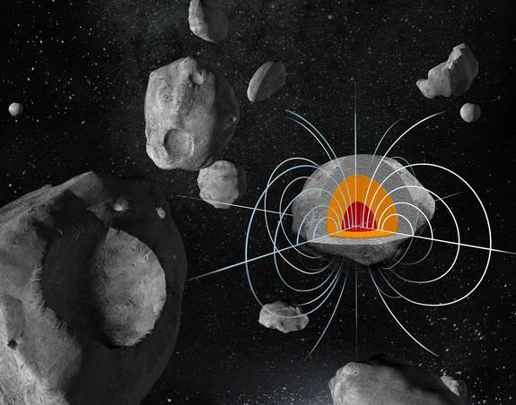
The huge metal asteroid Psyche may have a strong remnant magnetic field. Credit: Damir Gamulin/Ben Weiss
A robotic mission to Pysche would also help astronomers learn more about metal worlds, a type of solar system object that scientists know very little about. But perhaps the greatest reason to study 16 Psyche is the fact that it is unique. So far, this body is the only metallic core-like body that has been discovered in the Solar System.
The proposed spacecraft would orbit Psyche for six months, studying its topography, surface features, gravity, magnetism, and other characteristics. The mission would also be cost-effective and quick to launch, since it is largely based on technology that went into the making of NASA’s Dawn probe. Currently in orbit around Ceres, the Dawn mission has demonstrated the effectiveness of many new technologies, not the least of which was the xenon ion thruster.
The Psyche orbiter mission was selected as one of the Discovery Program’s five semifinalists on September 30th, 2015. Each proposal has received $3 million for year-long studies to lay out detailed mission plans and reduce risks. One or two finalist will be selected to receive the program’s budget of $450 million (minus the cost of a launch vehicle and mission operations) and will launch in 2020 at the earliest.