NASA’s GPM Sat Records Deadly ‘1000 Year’ Rain Devastating South Carolina from Nor’easter and Joaquin

Flooded streets and houses in South Carolina. Credit: Hap Griffin

Video Caption: NASA/JAXA’s GPM satellite measured record rainfall that fell over the Carolinas from September 26 to October 5, 2015 from a plume of moisture from Hurricane Joaquin when it was located over the Bahamas and moved to Bermuda. The IMERG showed highest rainfall totals near 1,000 mm (39.3 inches) in a small area of South Carolina and rainfall between 700 and 900 mm (27.5 and 37.4 inches) over a large area of South Carolina. Credits: SSAI/NASA/JAXA, Hal Pierce
See below ground level images and videos of storm devastation
Story updated with additional details/imagery from NASA and South Carolina

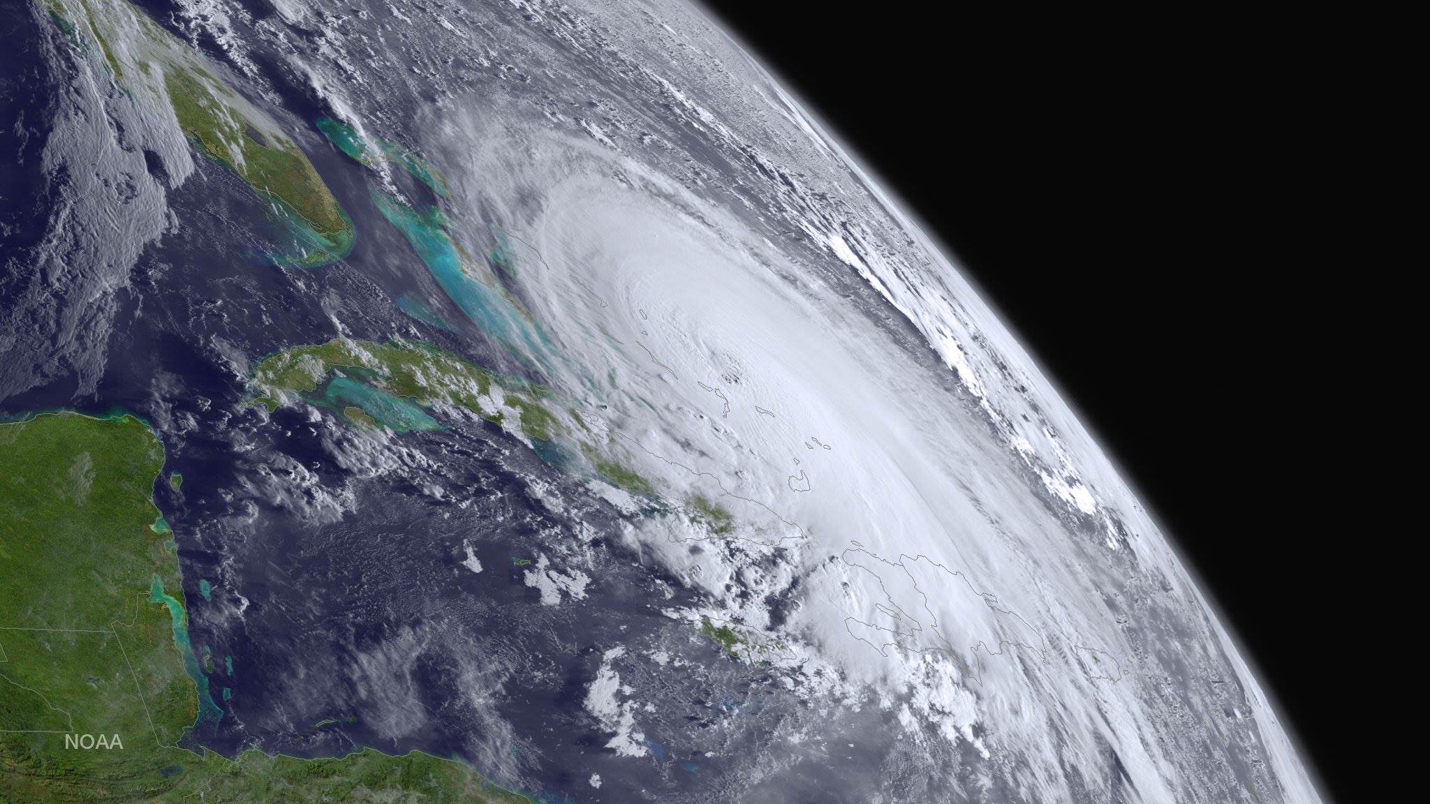
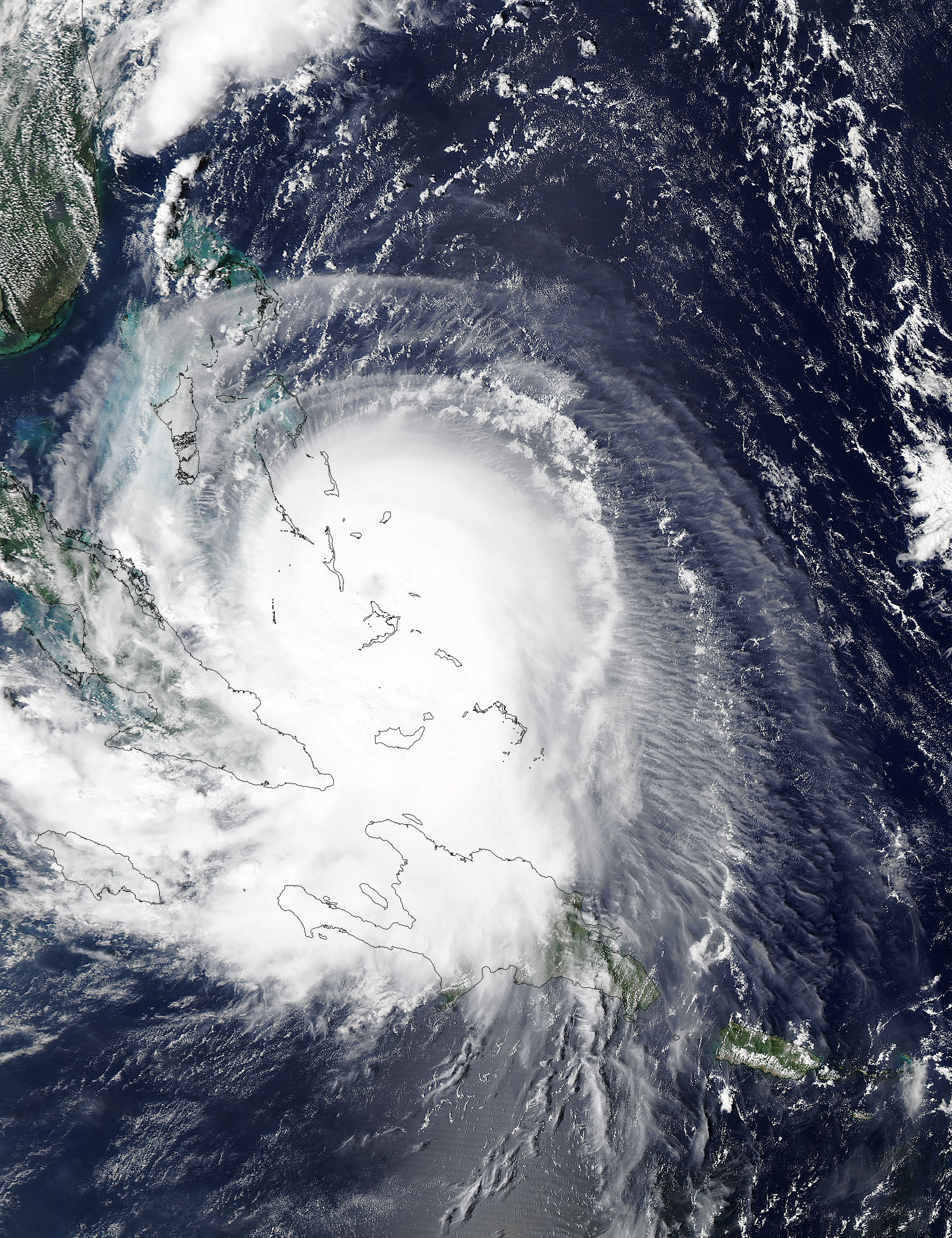
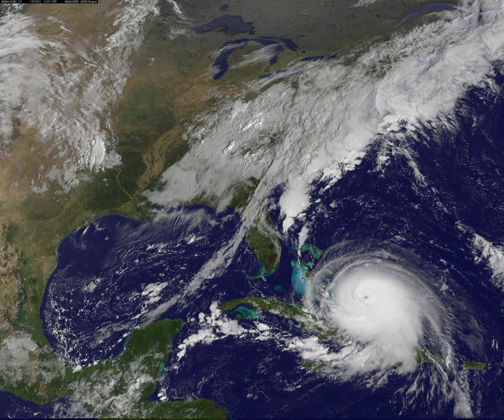
NASA’s advanced Global Precipitation Measurement (GPM) weather satellite is continuously tracking and recording the ‘1000 Year’ rainfall event heaping death and devastation across wide areas of South Carolina from the combined actions of a freak Nor’easter and Hurricane Joaquin – which reached a borderline Cat 5 status on Saturday, Oct. 3 with winds of 150 mph.

South Carolina Gov. Nikki Haley declared the historic and torrential rain fall to be a “1000 Year event” on Sunday, Oct. 4. “We have never seen anything like this.” Governor Haley and President Obama issued a “State of Emergency.”

Although the horrendous rains in South Carolina may nearly be done, the nor’easter caused damage estimated to be in the Billions of Dollars and at least 9 storm related deaths as of today, Monday, Oct. 5.

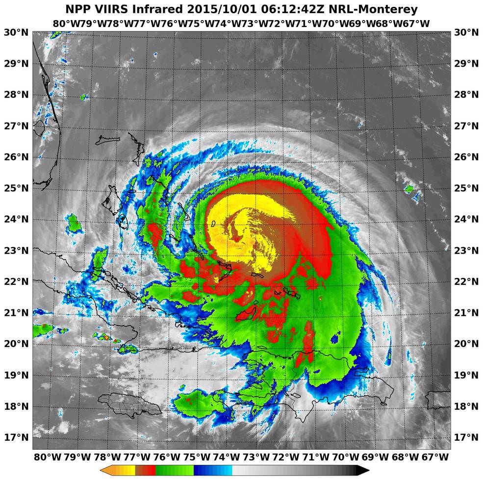
Rainfall totals ranging from 14 to 37 inches in local areas over the past week drenched a wide swath of the Palmetto state with never before seen flooding, according to NASA and NOAA. The most intense periods of rain fell over the weekend.

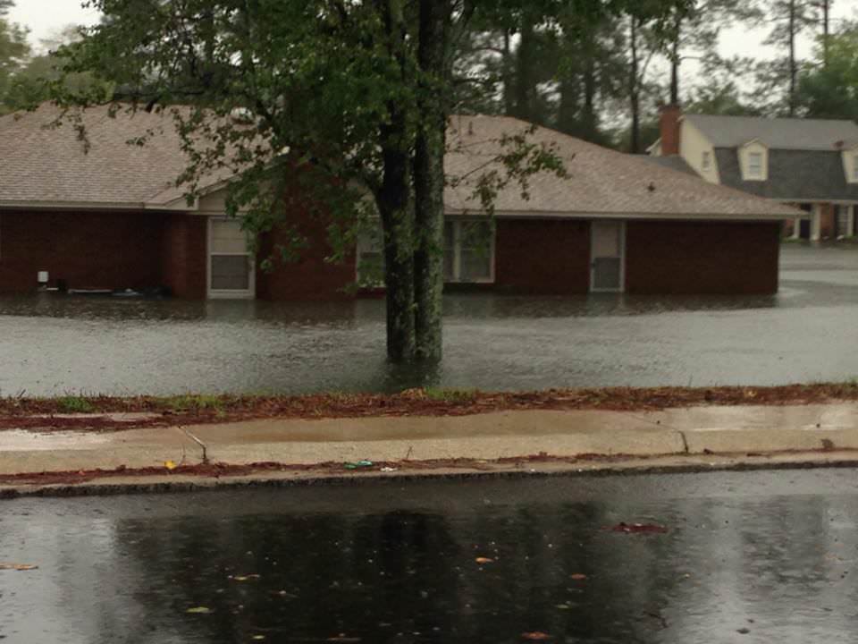
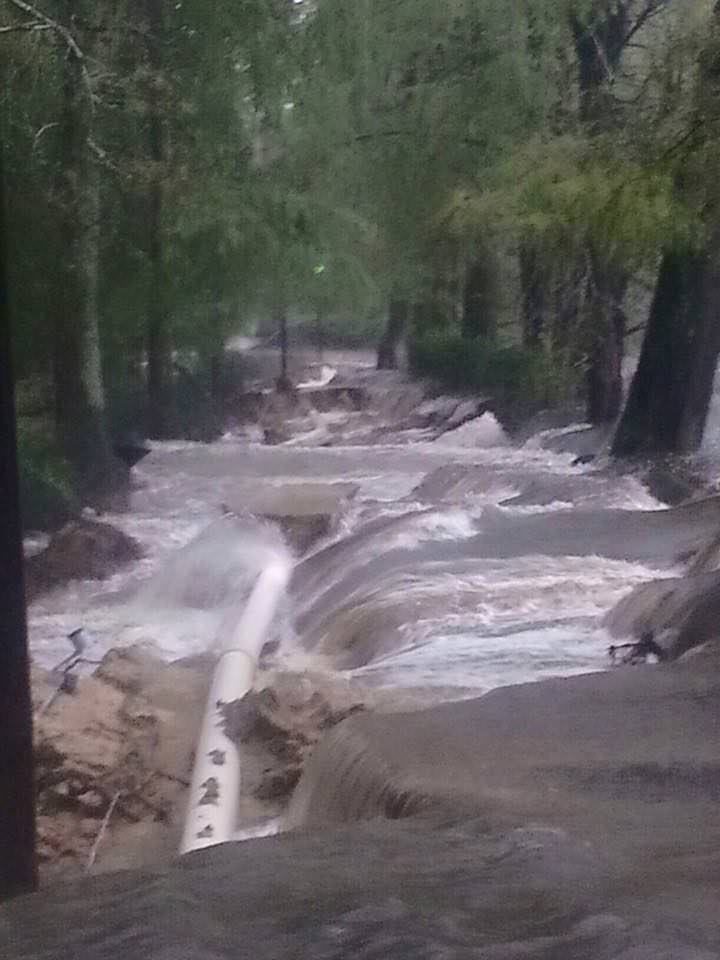
See herein a gallery of photos from friends and others living through the disaster in South Carolina.

NASA astronaut Scott Kelly also captured dramatic images of Hurricane Joaquin – as I reported earlier here.

A slew of NASA and NOAA orbiting weather satellites are constantly tracking the fierce storms and providing the state and federal governments with the most up to date forecasts to aid officials and emergency responders in evaluating and managing the disaster in the most effective manner possible.

NASA’s GPM and a global fleet of other international weather monitoring satellites gathered measurements every 30 minutes from September 26 to October 5, 2015 that were combined into the eyepoppongly dramatic IMERG (Integrated Multi-satellitE Retrievals for GPM) color-coded video above. It tracks the massive growth, spread and direction of the storms and shows the historic levels of destructive precipitation generated by the lethal pair of powerful storms.

The NASA GPM video shows plumes of moisture from the Nor’Easter and Hurricane Joaquin as they gather force and moved over South Carolina and through the Caribbean around and over the Bahamas and later as Joaquin fortunately veered away from the US eastern seaboard towards Bermuda.

“The IMERG showed highest rainfall totals near 1,000 mm (39.3 inches) in a small area of South Carolina and rainfall between 700 and 900 mm (27.5 and 37.4 inches) over a large area of South Carolina,” says NASA’s Hal Pierce.

Here’s a NASA video with NASA scientist Dalia Kirschbaum describing how GPM can see inside a hurricane to makes rainfall and precipitation measurements in 3D:

Video caption: NASA scientist Dalia Kirschbaum explains how the Global Precipitation Measurement Mission’s Core observatory has an instrument that can see layer by layer through a storm.

The GPM precipitation measurements come from both of its advanced radar instruments – the dual-frequency precipitation (DPR) radar instrument (Ku and Ka band) and the GPM microwave imager (GMI), NASA scientist George Huffman told Universe Today.

The IMERG video is based on an algorithm that also carefully combines and calibrates measurements gathered every 30 minutes from the passive microwave sensors flying aboard a large international constellation of satellites from the US, Europe, Japan and India – and outlined in complete detail further below by NASA’s Huffman and Kirschbaum; exclusively for Universe Today.

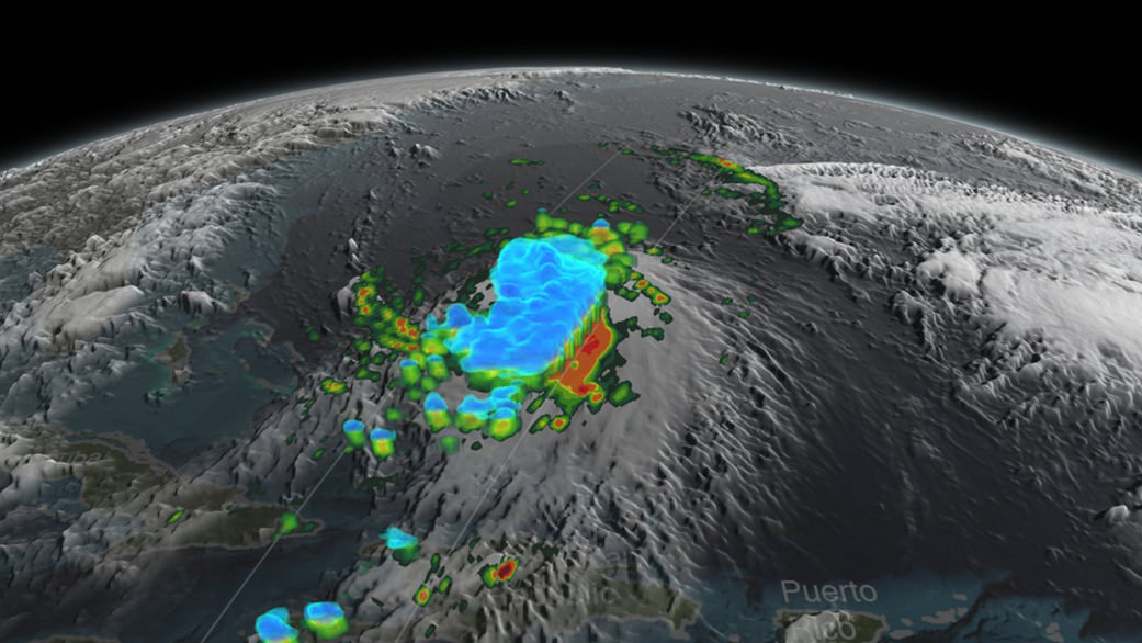
The visualization of data was created by NASAs Goddard’s Space Flight Center and shows Hurricane Joaquin around the Bahamas “when it was a tropical storm. Red and green colors show rain and the ice and snow at the top of the storm is visualized in blue.”

“Understanding hurricane structure helps weather forecasters around the world determine a storm’s structure and where it may be going,” says Kirschbaum.

Hurricane Joaquin was still packing winds exceeding 125 mph this morning, but it has lost strength throughout the day.

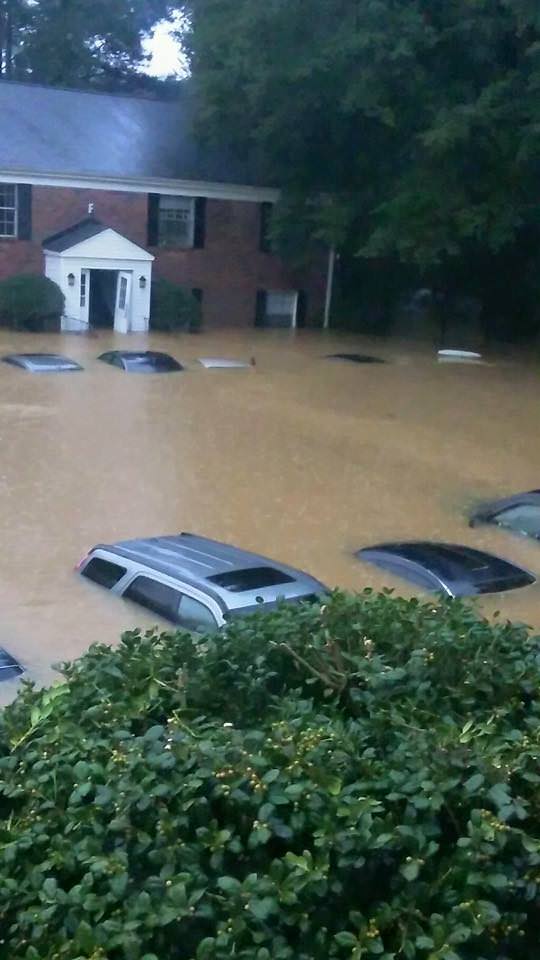
Over 40,000 homes and businesses are without power today, Oct. 5, in South Carolina due to the unending rain and widespread catastrophic flooding. And many folks had to be evacuated.

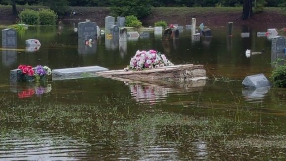
Some cemeteries were uprooted with caskets seen floating down flooded streets.

Residents are warned to stay out of the flood waters and standing waters that can be carrying bacteria and diseases presenting a significant health hazard.

In the capitol city of Columbia, there was widespread flooding with severe damage to water mains that cut off drinking water to over 15,000 people.

The governor deployed over 1300 national guard troops to render assistance. Over 150 folks were rescued by helicopter, some from the rooftops of their homes and apartments.

Here’s a helicopter rescue:

Video: Helicopter Rescue at Lakewood Links in Sumter, SC on Oct 4, 2014. Credit: Sean Reyes

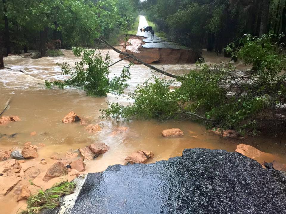
Scores of South Carolina residents were getting rescued by canoes and even boats where waters surged in places up to 25 feet above normal.

At least 9 dams have been breached statewide, as well as levees, requiring many thousands people more to be evacuated.

Dam at Swan Lake  in South Carolina on Oct. 4, 2015.  Credit: Edwin Corning
Dam at Swan Lake in South Carolina on Oct. 4, 2015. Credit: Edwin Corning

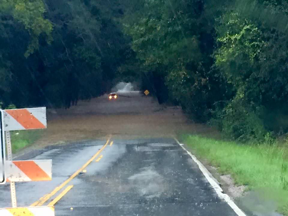
Governor Haley confirmed that over 550 roads were either closed, damaged or destroyed, including back roads and major interstate highways vital to the states and US national economy.

A 70 mile stretch of I-95, a major north-south artery traveled by millions including myself, was closed to all traffic on Sunday and remains closed today. And many side roads that could serve as potential detours are also closed.

Historically high water levels in some of the areas worst hit by flooding has finally receded. But in other areas water levels are rising.

In addition, the US Coast Guard says the cargo ship ‘El Faro’ with 33 people aboard is believed to have sunk because it ventured straight into Hurricane Joaquin. The ship’s crew included 28 Americans and 5 Polish sailors. It sank in the area popularly known as the ‘Bermida Triangle’ in water some 3 miles deep.

Today, the Coast Guard reported the discovery of a debris field over 25-square-miles wide. At least one crew member has already been found dead.

The El Faro set out from the port of Jacksonville on Tuesday when Joaquin was a tropical storm with 85 mph wind speed.

The last distress call on last Thursday morning, as the ship neared the eye of the Hurricane, then a Category 3. The ship was listing over 15 degrees surrounded by 30 foot high waves.

The hurricane quickly grew into a Cat 4 and no further word was heard from the ship. It may be 3 miles underwater at the bottom of the Atlantic Ocean.

How and from which fleet of satellites does NASA obtain the orbital measurements used to create the high resolution, color-coded GPM IMERG visualizations?

“The Integrated Multi-satellitE Retrievals for GPM (IMERG) creates a merged precipitation product from the GPM constellation of satellites. These satellites include DMSPs from the U.S. Department of Defense, GCOM-W from the Japan Aerospace Exploration Agency (JAXA), Megha-Tropiques from the Centre National D’etudies Spatiales (CNES) and Indian Space Research Organization (ISRO), NOAA series from the National Oceanic and Atmospheric Administration (NOAA), Suomi-NPP from NOAA-NASA, and MetOps from the European Organisation for the Exploitation of Meteorological Satellites (EUMETSAT),” NASA scientists George Huffman and Dalia Kirschbaum told me exclusively for Universe Today.

“All of the instruments (radiometers) onboard the constellation partners are intercalibrated with information from the GPM Core Observatory’s GPM Microwave Imager (GMI) and Dual-frequency Precipitation Radar (DPR). The data are gridded at 0.1°x0.1° lat./lon and provided in 30 minute time slices through morphing between satellite overpasses. The satellite estimates are then calibrated with rainfall gauge information.”

Here’s another GPM visualization of Hurricane Joaquin:

Stay tuned here for Ken’s continuing Earth and planetary science and human spaceflight news.

Ken Kremer

Hurricane Joaquin captured on Oct. 2, 2015 by NASA Astronaut Scott Kelly from the International Space Station. Credit: NASA/Scott Kelly
NASA’s next generation Global Precipitation Measurement (GPM) observatory inside the clean room at NASA Goddard Space Flight Center, MD. Technicians at work on final processing during exclusive up-close inspection tour by Universe Today.  GPM is slated to launch on February 27, 2014 and will provide global measurements of rain and snow every 3 hours. Credit: Ken Kremer/kenkremer.com
NASA’s next generation Global Precipitation Measurement (GPM) observatory inside the clean room at NASA Goddard Space Flight Center, MD. Technicians at work on final processing during exclusive up-close inspection tour by Universe Today. GPM wasn successfully launched on February 27, 2014 and will provide global measurements of rain and snow every 3 hours. Credit: Ken Kremer/kenkremer.com

More storm photos:

12105756_10153637500440842_3847639235805426523_n

650012-e5b15

12107230_10153637499835842_6765874301507514381_n

12141812_10153637499925842_692222812913222825_n

The Next Generation of Exploration: The DAVINCI Spacecraft

NASA's latest round of Discovery Program missions. Credit: NASA

It’s no secret that there has been a resurgence in interest in space exploration in recent years. Much of the credit for this goes to NASA’s ongoing exploration efforts on Mars, which in the past few years have revealed things like organic molecules on the surface, evidence of flowing water, and that the planet once had a denser atmosphere –  all of which indicate that the planet may have once been hospitable to life.

But when it comes to the future, NASA is looking beyond Mars to consider missions that will send missions to Venus, near-Earth objects, and a variety of asteroids. With an eye to Venus, they are busy investigating the possibility of sending the Deep Atmosphere Venus Investigation of Noble gases, Chemistry, and Imaging (DAVINCI) spacecraft to the planet by the 2020s.

Led by Lori Glaze of the Goddard Spaceflight Center, the DAVINCI descent craft would essentially pick up where the American and Soviet space programs left off with the Pioneer and Venera Programs in the 1970s and 80s. The last time either country sent a probe into Venus’ atmosphere was in 1985, when the Soviet probes Vega 1 and 2 both orbited the planet and released a balloon-supported aerobot into the upper atmosphere.

Model of the Vega 1 solar system probe bus and landing apparatus (model) - Udvar-Hazy Center, Dulles International Airport, Chantilly, Virginia, USA. Credit: historicspacecraft.com
Model of the Vega 1 probe and landing apparatus at the Udvar-Hazy Center, Dulles International Airport, Chantilly, Virginia. Credit: historicspacecraft.com

These probes both remained operational for 46 hours and discovered just how turbulent and powerful Venus’ atmosphere was. In contrast, the DAVINCI probe’s mission will be to study both the atmosphere and surface of Venus, and hopefully shed some light on some of the planet’s newfound mysteries. According to the NASA release:

“DAVINCI would study the chemical composition of Venus’ atmosphere during a 63-minute descent. It would answer scientific questions that have been considered high priorities for many years, such as whether there are volcanoes active today on the surface of Venus and how the surface interacts with the atmosphere of the planet.”

These studies will attempt to build upon the data obtained by the Venus Express spacecraft, which in 2008/2009 noted the presence of several infrared hot spots in the Ganis Chasma region near the the shield volcano of Maat Mons (shown below). Believed to be due to volcanic eruptions, this activity was thought to be responsible for significant changes that were noted in the sulfur dioxide (SO²) content in the atmosphere at the time.

What’s more, the Pioneer Venus spacecraft – which studied the planet’s atmosphere from 1978 until its orbit decayed in 1992 – noted a tenfold decreased in the density of SO² at the cloud tops, which was interpreted as a decline following an episode of volcanogenic upwelling from the lower atmosphere.

3-D perspective of the Venusian volcano, Maat Mons generated from radar data from NASA’s Magellan mission.
3-D perspective of the Venusian volcano, Maat Mons, generated from radar data from NASA’s Magellan mission. Credit: NASA/JPL

Commonly associated with volcanic activity here on Earth, SO² is a million times more abundant in Venus’ atmosphere, where it helps to power the runaway greenhouse effect that makes the planet so inhospitable. However, any SO² released into Venus’ atmosphere is also short-lived, being broken down by sunlight within a matter of days.

Hence, any significant changes in SO² levels in the upper atmosphere must have been a recent addition, and some scientists believe that the spike observed in 2008/2009 was due to a large volcano (or several) erupting. Determining whether or not this is the case, and whether or not volcanic activity plays an active role in the composition of Venus’s thick atmosphere, will be central to DAVINCI’s mission.

Along with four other mission concepts, DAVINCI was selected as a semifinalist for the NASA Discovery Program‘s latest calls for proposed missions. Every few years, the Discovery Program – a low-cost planetary missions program that is managed by the JPL’s Planetary Science Division – puts out a call for missions with an established budget of around $500 million (not counting the cost of launch or operation).

The latest call for submissions took place in February 2014, as part of the Discovery Mission 13. At the time, a total of 27 teams threw their hats into the ring to become part of the next round of space exploration missions. Last Wednesday, September 30th, 2015, five semifinalists were announced, one (or possibly two) of which will be chosen as the winner(s) by September 2016.

Artist rendition of NASA’s Mars InSight (Interior exploration using Seismic Investigations, Geodesy and Heat Transport) Lander. InSight is based on the proven Phoenix Mars spacecraft and lander design with state-of-the-art avionics from the Mars Reconnaissance Orbiter (MRO) and Gravity Recovery and Interior Laboratory (GRAIL) missions. Credit: JPL/NASA
Artist rendition of NASA’s Mars InSight (Interior exploration using Seismic Investigations, Geodesy and Heat Transport) Lander, which was selected as part of the Discovery Programs 2010 call for submissions and will be launched by 2016. Credit: JPL/NASA

These finalists will receive $3 million in federal grants for detailed concept studies, and the mission (or missions) that are ultimately chosen will be launched by December 31st, 2021. The Discovery Program began back in 1992, and launched its first mission- the Mars Pathfinder – in 1996. Other Discovery missions include the NEAR Shoemaker probe that first orbited an asteroid, and the Stardust-NExT project, which returned samples of comet and interstellar dust to Earth.

NASA’s MESSENGER spacecraft, the planet-hunting Kepler telescope, and the Dawn spacecraft were also developed and launched under the Discovery program. The winning proposal of the Discovery Program’s 12th mission, which was issued back in 2010, was the InSight Mars lander. Set to launch in March of 2016, the lander will touch down on the red planet, deploy instruments to the planet’s interior, and measure its seismic activity.

NASA hopes to infuse the next mission with new technologies, offering up government-furnished equipment with incentives to sweeten the deal for  each proposal. These include a supply of deep space optical communications system that are intended to test new high-speed data links with Earth. Science teams that choose to incorporate the laser telecom unit will be entitled to an extra $30 million above their $450 million cost cap.

If science teams wish to send entry probes into the atmospheres of Venus or Saturn, they will need a new type of heat shield. Hence, NASA’s solicitation includes a provision to furnish a newly-developed 3D-woven heat shield with a $10 million incentive. A deep space atomic clock is also available with a $5 million bonus, and NASA has offered to provide xenon ion thrusters and radioisotope heater units without incentives.

As with previous Discovery missions, NASA has stipulated that the mission must use solar power, limiting mission possibilities beyond Jupiter and Saturn. Other technologies may include the NEXT ion thruster and/or re-entry technology.

Invest a Night in Vesta

The planetoid Vesta, which was studied by the Dawn probe between July 2011 and September 2012. Credit: NASA

The brightest asteroid visible from Earth prowls across Cetus the Whale this month. Vesta shines at magnitude +6.3, right at the naked eye limit for observers with pristine skies, but easily coaxed into view with any pair of binoculars. With the moon now gone from the evening sky, you can start your search tonight. 

4 Vesta - its formal designation as the fourth asteroid discovered - travels along a short arc just south of the easily-found star Iota Ceti this month. Use this map to help you find Deneb Kaitos, Cetus' brightest star, and from their to Iota Ceti and Vesta. Source: Stellarium
Facing southeast around 10 p.m. local time in early October. 4 Vesta — its formal designation as the fourth asteroid discovered — travels along a short arc south of the easily-found star, Iota Ceti. Shoot a line from the Square of Pegasus south to arrive at Deneb Kaitos, Cetus’ brightest star, and from their to Iota Ceti and Vesta. Detailed map below. Source: Stellarium

Vesta came to opposition on September 28 and remains well-placed for viewing through early winter. Today’s it’s 134 million miles (225 million km) from Earth or about 5 million miles farther the Mars’ average distance from us. Although it’s one of the largest asteroids in the inner asteroid belt between Mars and Jupiter with a diameter of 326 miles (525 km), it never appears larger than a point of light even in many professional telescopes. Your binocular view will be as satisfying as the one through Mt. Palomar.

A spectacular central peak more than 14 miles high rises from the 310-mile-wide crater Rheasilvia. Credit: NASA
Like an inverted belly button, a spectacular central peak more than 14 miles high rises from the 310-mile-wide crater Rheasilvia. Credit: NASA

Discovered by the German astronomer Heinrich Olbers in March 1807, Vesta was named for the Roman goddess of home and hearth. NASA’s Dawn spacecraft, currently in orbit around another asteroid, Ceres, visited Vesta between July 2011 and September 2012, taking thousands of close-up images and measuring the mineral make-up of its soil and crust. We learned a few things while we were there:

  • Vesta is differentiated into crust, mantle and core just like the bigger planets are. That’s why you’ll sometimes hear it described as a “protoplanet”, the first of its kind discovered in our solar system.
  • A class of igneous meteorites fallen to Earth called Howardites, eucrites and diogenites (HED-meteorites) were confirmed as actual pieces of the asteroid that found their way here after being blasted into space by impact.
  • Some of the meteorites / rocks that pelted the asteroid from elsewhere in the solar system are water-rich.
  • Vesta’s covered in craters like the moon
  • A staggering-large 310-mile-wide (500 km) impact crater named Rheasilvia marks its south pole. The basin’s central peak rises to 14.3 miles (23 km), more than twice the height of Mt. Everest.
  • Gullies found on its surface suggest ancient water flows.
Cornelia Crater on the large asteroid Vesta. The crater is about 4 to 5 million years old. On the right is an inset image showing an example of curved gullies, indicated by the short white arrows, and a fan-shaped deposit, indicated by long white arrows. The inset image is about 0.62 miles (1 kilometer) wide.
Cornelia Crater on the asteroid Vesta. The crater is about 4 to 5 million years old. On the right is an inset image showing an example of curved gullies that may have been carved by water, indicated by the short white arrows, and a fan-shaped deposit, indicated by long white arrows. The inset image is about 0.62 miles (1 km) wide. Credit: NASA/JPL-Caltech/UCLA/MPS/DLR/IDA

You can see it all in your mind’s eye the next clear night. For skywatchers at mid-northern latitudes, Vesta climbs into good view around 10 o’clock in early October and 8 o’clock by month’s end. If you’re familiar with gangly Cetus, you can start with the 2nd magnitude star Deneb Kaitos, the brightest star in the constellation. If not, begin your Vestan voyage from the Great Square in Pegasus, high in the southeastern sky.

Once you've arrived at Deneb Kaitos, locate Iota Ceti, 10 degrees to the northwest. The star makes finding Vesta easy in binoculars this month. Source: Chris Marriott's SkyMap software
Once you’ve arrived at Deneb Kaitos, locate Iota Ceti, 10 degrees to the northwest. The star makes finding Vesta easy in binoculars this month. Stars shown to magnitude +7. North is up and the asteroid’s position is marked every 5 days  at 10 p.m. Vesta fades slowly during the month to mag. 6.8 by Nov. 1. CDT. Source: Chris Marriott’s SkyMap software

Drop a line through the two stars along the left side of the Square and continue it down toward the southern horizon. You’ll run right into DK. Now elevate your gaze — or aim your binoculars — one outstretched fist (10°) or about two binocular fields of view above and right of Deneb Kaitos to find Iota Ceti (mag. 3.6).

Once you’ve got Iota, the asteroid will be in your field of view close by. Use the detailed chart to pinpoint its location with respect to Iota. Easy, right? Well, I hope so. Bon voyage to Vesta!

Borderline Cat 5 Hurricane Joaquin Spied from International Space Station

Hurricane Joaquin captured on Oct. 2, 2015 by NASA Astronaut Scott Kelly from the International Space Station. Credit: NASA/Scott Kelly

As the powerful category 4 Hurricane Joaquin was pounding the Bahamas and packing winds of over 130 mph, NASA astronaut Scott Kelly captured a stunning photo of Joaquin on Friday morning, Oct. 2 from his perch aboard the International Space Station (ISS). As of today, Oct. 3. Joaquin has gained strength to 150 mph and is a borderline Cat 5 storm!

Coincidentally, Kelly snapped the photo within hours of the milestone 100th straight successful rocket launch by United Launch Alliance (ULA) on Oct. 2, of the firms Atlas V rocket carrying Mexico’s next generation Morelos-3 communications satellite from Florida to orbit.

Kelly’s spectacular storm photo shows the eye of Hurricane Joaquin over the Caribbean and off the US eastern seaboard with the limb of the Earth and our atmosphere in beautiful detail.

Huge thunderstorms can been off to the north of the immense category 4 storm.

And as of today, Saturday, Oct. 3, Hurricane Joaquin has further strengthened and is now packing maximum sustained winds of 150 MPH or 240 KM/H, according to the latest advisory issued by the National Hurricane Center (NHC) as of 5 p.m. EDT.

Kelly posted the Oct. 2 photo of Joaquin with this caption on his twitter account:

“Early morning shot of Hurricane #Joaquin from @space_station before reaching #Bahamas. Hope all is safe. #YearInSpace.”

Two of the stations solar panels are seen in the photo as well as portions of the US east coast including Florida.

The latest NHC forecast shows Joaquin veering away from the US East Coast. But it’s still creating hurricane force winds and high waves that is threatening Bermuda.

“SEVERE HURRICANE JOAQUIN THREATENING BERMUDA,” said the NHC today.

It is moving northeast at 45 degrees at 17 MPH or 28 KM/H.

Kelly snapped another telling view of Joaquin on Thursday, Oct. 1 showing the Bahamas and Miami in the field of view.

Kelly tweeted; “#HurricaneJoaquin churns over the #Bahamas with #Miami in the field of view from @Space_Station.”

#HurricaneJoaquin churns over the #Bahamas with #Miami in the field of view from @Space_Station #YearInSpace.  Credit: NASA/Scott Kelly
#HurricaneJoaquin churns over the #Bahamas with #Miami in the field of view from @Space_Station #YearInSpace. Credit: NASA/Scott Kelly

Scott Kelly is a member of the first ever 1 year ISS mission crew comprising Kelly and Russian cosmonaut Mikhail Kornienko.

They arrived at the ISS in March and had just reached the midpoint of their nearly 12 month stay aimed at conducting research to explore the impact of long term stays in space on the human body and aid NASA’s long term plans for a human ‘Journey to Mars’ in the 2030s.

NASA and NOAA satellites are keeping constant watch on the progress of the powerful Hurricane Joaquin, that earlier had the potential to barrel towards tens of millions of US coastal residents.

Here’s another stunning view of Hurricane Joaquin taken by the GOES-West satellite on Oct. 1.

This stunning image of Hurricane Joaquin is from NOAA's GOES West satellite on Oct. 1 2015. Many portions of the eastern U.S. are currently experiencing heavy rains and gusty winds associated with a frontal system.   Credit: NOAA
This stunning image of Hurricane Joaquin is from NOAA’s GOES West satellite on Oct. 1 2015. Many portions of the eastern U.S. are currently experiencing heavy rains and gusty winds associated with a frontal system. Credit: NOAA

This visible image from NASA’s Aqua satellite shows Hurricane Joaquin over Bahamas on Oct. 1.

NASA's Aqua satellite captured this visible image of Hurricane Joaquin over Bahamas on Oct. 1 at 17:55 UTC (1:55 p.m. EDT).  Credits: NASA Goddard MODIS Rapid Response Team
NASA’s Aqua satellite captured this visible image of Hurricane Joaquin over Bahamas on Oct. 1 at 17:55 UTC (1:55 p.m. EDT). Credits: NASA Goddard MODIS Rapid Response Team

Stay tuned here for Ken’s continuing Earth and planetary science and human spaceflight news.

Ken Kremer

Charon Suffered Surprisingly Titanic Upheavals in Fresh Imagery from New Horizons

Charon in Enhanced Color. NASA's New Horizons captured this high-resolution enhanced color view of Charon just before closest approach on July 14, 2015. The image combines blue, red and infrared images taken by the spacecraft’s Ralph/Multispectral Visual Imaging Camera (MVIC); the colors are processed to best highlight the variation of surface properties across Charon. Charon’s color palette is not as diverse as Pluto’s; most striking is the reddish north (top) polar region, informally named Mordor Macula. Charon is 754 miles (1,214 kilometers) across; this image resolves details as small as 1.8 miles (2.9 kilometers). Credits: NASA/JHUAPL/SwRI

Charon in Enhanced Color with Grand Canyon
NASA’s New Horizons captured this high-resolution enhanced color view of Charon and its Grand Canyon just before closest approach on July 14, 2015. The image combines blue, red and infrared images taken by the spacecraft’s Ralph/Multispectral Visual Imaging Camera (MVIC); the colors are processed to best highlight the variation of surface properties across Charon. Charon’s color palette is not as diverse as Pluto’s; most striking is the reddish north (top) polar region, informally named Mordor Macula. Charon is 754 miles (1,214 kilometers) across; this image resolves details as small as 1.8 miles (2.9 kilometers). Credits: NASA/JHUAPL/SwRI[/caption]

Charon suffered such a surprisingly violent past of titanic upheavals that they created a humongous canyon stretching across the entire face of Pluto’s largest moon – as revealed in a fresh batch of images just returned from NASA’s New Horizons spacecraft.

We have been agog in amazement these past few weeks as New Horizons focused its attention on transmitting astounding high resolution imagery and data of Pluto, captured during mankind’s history making first encounter with our solar systems last unexplored planet on July 14, 2015, at a distance of 7,750 miles (12,500 kilometers).

Now after tantalizing hints we see that Charon, Pluto’s largest moon, did
not disappoint and is no less exciting than the “snakeskin texture mountains” of Pluto revealed only last week.

“You’ll love this,” said New Horizons Principal Investigator Alan Stern of the Southwest Research Institute, Boulder, Colorado, in a blog posting.

Indeed researches say Charon’s tortured landscape of otherworldly canyons, mountains and more far exceeds scientists preconceived notions of a “monotonous, crater-battered world; instead, they’re finding a landscape covered with mountains, canyons, landslides, surface-color variations and more.”

“We thought the probability of seeing such interesting features on this satellite of a world at the far edge of our solar system was low,” said Ross Beyer, an affiliate of the New Horizons Geology, Geophysics and Imaging (GGI) team from the SETI Institute and NASA Ames Research Center in Mountain View, California, in a statement.

“But I couldn’t be more delighted with what we see.”

Measuring 754 miles (1,214 kilometers) across, Charon is half the diameter of Pluto and forms a double planet system. Charon also ranks as the largest satellite relative to its planet in the solar system. By comparison, Earth’s moon is one quarter the size of our home planet.

The new images of the Pluto-facing hemisphere of Charon were taken by New Horizons’ Long Range Reconnaissance Imager (LORRI) and the Ralph/Multispectral Visual Imaging Camera (MVIC) during the July 14 flyby and downlinked over about the past week and a half.

They reveal details of a belt of fractures and canyons just north of the moon’s equator.

High-resolution images of Charon were taken by the Long Range Reconnaissance Imager on NASA’s New Horizons spacecraft, shortly before closest approach on July 14, 2015, and overlaid with enhanced color from the Ralph/Multispectral Visual Imaging Camera (MVIC). Charon’s cratered uplands at the top are broken by series of canyons, and replaced on the bottom by the rolling plains of the informally named Vulcan Planum. The scene covers Charon’s width of 754 miles (1,214 kilometers) and resolves details as small as 0.5 miles (0.8 kilometers).  Credits: NASA/JHUAPL/SwRI
High-resolution images of Charon were taken by the Long Range Reconnaissance Imager on NASA’s New Horizons spacecraft, shortly before closest approach on July 14, 2015, and overlaid with enhanced color from the Ralph/Multispectral Visual Imaging Camera (MVIC). Charon’s cratered uplands at the top are broken by series of canyons, and replaced on the bottom by the rolling plains of the informally named Vulcan Planum. The scene covers Charon’s width of 754 miles (1,214 kilometers) and resolves details as small as 0.5 miles (0.8 kilometers). Credits: NASA/JHUAPL/SwRI

The “Grand Canyon of Charon” stretches more than 1,000 miles (1,600 kilometers) across the entire face of Charon visible in the new images. Furthermore the deep canyon probably extends onto the far side of Pluto and hearkens back to Valles Marineris on Mars.

“It looks like the entire crust of Charon has been split open,” said John Spencer, deputy lead for GGI at the Southwest Research Institute in Boulder, Colorado, in a statement.

“With respect to its size relative to Charon, this feature is much like the vast Valles Marineris canyon system on Mars.”

Charon’s “Grand Canyon” is four times as long as the Grand Canyon of the United States. Plus its twice as deep in places. “These faults and canyons indicate a titanic geological upheaval in Charon’s past,” according to the New Horizons team.

This composite of enhanced color images of Pluto (lower right) and Charon (upper left), was taken by NASA’s New Horizons spacecraft as it passed through the Pluto system on July 14, 2015. This image highlights the striking differences between Pluto and Charon. The color and brightness of both Pluto and Charon have been processed identically to allow direct comparison of their surface properties, and to highlight the similarity between Charon’s polar red terrain and Pluto’s equatorial red terrain. Pluto and Charon are shown with approximately correct relative sizes, but their true separation is not to scale. The image combines blue, red and infrared images taken by the spacecraft’s Ralph/Multispectral Visual Imaging Camera (MVIC).  Credits: NASA/JHUAPL/SwRI
This composite of enhanced color images of Pluto (lower right) and Charon (upper left), was taken by NASA’s New Horizons spacecraft as it passed through the Pluto system on July 14, 2015. This image highlights the striking differences between Pluto and Charon. The color and brightness of both Pluto and Charon have been processed identically to allow direct comparison of their surface properties, and to highlight the similarity between Charon’s polar red terrain and Pluto’s equatorial red terrain. Pluto and Charon are shown with approximately correct relative sizes, but their true separation is not to scale. The image combines blue, red and infrared images taken by the spacecraft’s Ralph/Multispectral Visual Imaging Camera (MVIC). Credits: NASA/JHUAPL/SwRI

Another intriguing finding is the area south of the canyon is much smoother, with fewer craters and may have been resurfaced by a type of “cryovolcanism.”

The southern plains are informally named “Vulcan Planum” and may be much younger.

“The team is discussing the possibility that an internal water ocean could have frozen long ago, and the resulting volume change could have led to Charon cracking open, allowing water-based lavas to reach the surface at that time,” said Paul Schenk, a New Horizons team member from the Lunar and Planetary Institute in Houston.

The piano shaped probe gathered about 50 gigabits of data as it hurtled past Pluto, its largest moon Charon and four smaller moons.

Barely 5 or 6 percent of the 50 gigabits of data captured by New Horizons has been received by ground stations back on Earth due to the slow downlink rate.

Stern says it will take about a year for all the data to get back. Many astounding discoveries await.

“I predict Charon’s story will become even more amazing!” said mission Project Scientist Hal Weaver, of the Johns Hopkins University Applied Physics Laboratory in Laurel, Maryland.

New Horizons science team co-investigator John Spencer examines print of the newest Pluto image taken on July 13, 2015 after the successful Pluto flyby. Credit: Ken Kremer/kenkremer.com

Stay tuned here for Ken’s continuing Earth and planetary science and human spaceflight news.

Ken Kremer

This new global mosaic view of Pluto was created from the latest high-resolution images to be downlinked from NASA’s New Horizons spacecraft and released on Sept. 11, 2015.   The images were taken as New Horizons flew past Pluto on July 14, 2015, from a distance of 50,000 miles (80,000 kilometers).  This new mosaic was stitched from over two dozen raw images captured by the LORRI imager and colorized.  Annotated with informal place names.  Credits: NASA/Johns Hopkins University Applied Physics Laboratory/Southwest Research Institute/Marco Di Lorenzo/Ken Kremer/kenkremer.com
This new global mosaic view of Pluto was created from the latest high-resolution images to be downlinked from NASA’s New Horizons spacecraft and released on Sept. 11, 2015. The images were taken as New Horizons flew past Pluto on July 14, 2015, from a distance of 50,000 miles (80,000 kilometers). This new mosaic was stitched from over two dozen raw images captured by the LORRI imager and colorized. Annotated with informal place names. Credits: NASA/Johns Hopkins University Applied Physics Laboratory/Southwest Research Institute/Marco Di Lorenzo/Ken Kremer/kenkremer.com

US Braces for Cat 4 Hurricane as ‘Joaquin’ Barrels to East Coast and ULA Readies 100th Launch on Oct. 2: Watch Live

NOAA's GOES-East satellite captured this visible image of Hurricane Joaquin affecting the Bahamas on Thursday, Oct. 1 at 1255 UTC. Credits: NASA/NOAA GOES Project

Video caption: This animation of images captured from September 29 to October 1, 2015 from NOAA’s GOES-East satellite shows Hurricane Joaquin become a major hurricane in the Bahamas. Credits: NASA/NOAA GOES Project

NEW JERSEY – A wide swath of the US East Coast is bracing for impact in the coming days as ‘Hurricane Joaquin’ strengthened to a major and dangerous Category 4 storm, today, Thursday, Oct. 1, as NASA and NOAA satellites keep constant watch as it barrels potentially towards tens of millions of coastal residents.

Joaquin is already packing winds exceeding 130 mph with even higher wind gusts as the storm continues to strengthen at this hour and the pressure is decreasing. See the latest Hurricane Joaquin animation and imagery from NASA and NOAA, above and below.

Meanwhile amidst the hurricane watch, launch preparations are underway by United Launch Alliance (ULA) for the firms 100th rocket blastoff on Friday morning, Oct. 2 from Cape Canaveral Air Force Station in Florida with an Atlas V booster as Joaquin nears the US eastern seaboard.

A ULA Atlas V is slated to lift off Friday from Cape Canaveral Air Force Station in Florida at 6:08 a.m. EDT with the Morelos-3 communications satellite for Mexico, before the hurricane gets closer to Florida.

The National Hurricane Center declared Joaquin had intensified into a massive Category 4 hurricane on the Saffir-Simpson Wind Scale, as of 2 PM EDT today, Oct. 1.

You can watch the launch on ULA’s live webcast starting at 5:48 a.m. Oct 2: http://www.ulalaunch.com

The governors of three states – New Jersey, Virginia and North Carolina – have already declared ‘States of Emergency’ in anticipation of potentially destructive winds, potentially life threatening drenching rains and floods, downed power lines and ocean rip currents with high waves in local areas.

Multiple NASA and NOAA satellites are intensively and continuously observing Joaquin, and are providing absolutely critical data to forecasters and government officials with the most current and best information available.

NASA’s GPM, Terra and NPP-Suomi satellites and NOAA’s GOES-East satellite are tracking Joaquin and have seen powerful thunderstorms today which indicates continued strengthening.

At this time we still don’t whether the US eastern seaboard will suffer a major hit but officials are taking no chances after suffering through Superstorm Sandy which caused many deaths, widespread power outages and billions and billions of dollars of damage – from which we are still recovering.

Joaquin is currently over The Bahamas in the Caribbean and is expected to make a sharp right turn on Friday Oct 2 and head northwards to the east coast and the Atlantic Ocean. It could start impacting the Carolinas and regions further north as soon as Sunday, Oct. 4, based on current forecasts, and drop double digits inches of torrential rainfall.

NASA-NOAA's Suomi NPP satellite passed over Joaquin at 06:10 UTC (2:10 a.m. EDT) on Oct. 1 as it was strengthening from a Category 2 to a Category 3 hurricane. It’s now a Category 4. Imagery showed cloud top temperatures colder than -63F/-53C (yellow).  Credits: NRL/NASA/NOAA
NASA-NOAA’s Suomi NPP satellite passed over Joaquin at 06:10 UTC (2:10 a.m. EDT) on Oct. 1 as it was strengthening from a Category 2 to a Category 3 hurricane. It’s now a Category 4. Imagery showed cloud top temperatures colder than -63F/-53C (yellow). Credits: NRL/NASA/NOAA

Its pounding the Bahamas right now and is creating a disaster with hurricane force winds and heavy rainfall, say weather forecasters, as it remains over the island for some 24 hours or more and may drop over 10 inches of rain.

But there is a very wide cone of uncertainly of where it could hit as the possible storm track extends from the Carolinas to Maine. It may or may not directly impact the eastern US. The storm may shift to the right and spare the east coast. But no one knows at this time.

Some areas on the US East coast stretching from Virginia to Maine have already suffered from torrential rains and severe flooding from an unrelated storm the past few days and also right now today, Thursday.

So the grounds are already saturated in parts of the Carolina’s, Virginia, Maine and elsewhere.

NASA/JAXA's GPM satellite provided a 3-D side view of Tropical Storm Joaquin on Sept. 29 showing the internal precipitation structure. The areas in blue are frozen precipitation. Areas in green and red are liquid precipitation.  Credits: Scientific Visualization Studio, NASA’s Goddard Space Flight Center
NASA/JAXA’s GPM satellite provided a 3-D side view of Tropical Storm Joaquin on Sept. 29 showing the internal precipitation structure. The areas in blue are frozen precipitation. Areas in green and red are liquid precipitation. Credits: Scientific Visualization Studio, NASA’s Goddard Space Flight Center

Coastal flood warnings and watches are already in effect in many areas along the eastern seaboard where local areas could be drenched by some 12 to 18 inches of additional rain which could fall even before the hurricane hits.

Significant beach erosion has already occurred in the Carolinas over the past few days and more is expected up and down the entire coast up to Maine.

And 10 foot high defense berms of sand are being constructed at this moment along miles and miles of the Jersey Shore – areas that suffered devastating damage from Superstorm Sandy.

There is a potential risk of deadly flooding, flash flooding and damage to houses, buildings, businesses, roadways and infrastructure.

“At 2 p.m. EDT (1800 UTC), the center of Hurricane Joaquin was located near latitude 23.0 North, longitude 74.2 West. Joaquin was moving generally southwestward at about 6 mph (9 kph), and the National Hurricane Center forecast a turn toward the northwest and north on Friday, Oct. 2. On the forecast track, the center of Joaquin will move near or over portions of the central Bahamas today and tonight and pass near or over portions of the northwestern Bahamas on Friday, Oct. 2,” according to NASAs Rob Gutro.

The weather forecast for Friday’s launch from Cape Canaveral , Florida is currently 70 percent GO for liftoff of the United Launch Alliance Atlas V rocket at 6:08 a.m. EDT. The Atlas V will launch with the Morelos-3 mission for Mexico’s Secretaria de Comunicaciones y Transportes (Ministry of Communications and Transportation).

Morelos-3 will be part of the Mexsat constellation of satellites that delivers advanced telecommunications throughout Mexico.

United Launch Alliance Atlas V rocket after rollout to Pad 41 at Cape Canaveral Air Force Station, Florida for planned Oct. 2 launch at 6:08 a.m. EDT with the Morelos-3 mission for Mexico’s Ministry of Communications and Transportation.  In progress assembly of the commercial crew access tower is seen at right, now under construction for the Boeing Starliner space taxi for astronaut crews launching to the ISS. Credit: Julian Leek
United Launch Alliance Atlas V rocket after rollout to Pad 41 at Cape Canaveral Air Force Station, Florida for planned Oct. 2 launch at 6:08 a.m. EDT with the Morelos-3 mission for Mexico’s Ministry of Communications and Transportation. In progress assembly of the commercial crew access tower is seen at right, now under construction for the Boeing Starliner space taxi for astronaut crews launching to the ISS. Credit: Julian Leek

Stay tuned here for Ken’s continuing Earth and planetary science and human spaceflight news.

Ken Kremer

United Launch Alliance Atlas V rocket during rollout to Space Launch Complex-41 at Cape Canaveral Air Force Station, Florida on Oct. 1 for planned Oct. 2 launch at 6:08 a.m. EDT with the Morelos-3 mission for Mexico’s Ministry of Communications and Transportation.  Credit: Julian Leek
United Launch Alliance Atlas V rocket during rollout to Space Launch Complex-41 at Cape Canaveral Air Force Station, Florida on Oct. 1 for planned Oct. 2 launch at 6:08 a.m. EDT with the Morelos-3 mission for Mexico’s Ministry of Communications and Transportation. Credit: Julian Leek

Scientists Tantalized as Dawn Yields Global Mineral and Topographic Maps of Ceres

This map-projected view of Ceres was created from images taken by NASA's Dawn spacecraft during its high-altitude mapping orbit, in August and September, 2015. This color coded map can provide valuable insights into the mineral composition of the surface, as well as the relative ages of surface features. Credits: NASA/JPL-Caltech/UCLA/MPS/DLR/IDA

Slowly but surely the mysteries of dwarf planet Ceres are being peeled back layer by layer as NASA’s Dawn spacecraft orbits lower and lower and gathers detailed measurements that have now yielded global mineral and topographic maps, tantalizing researchers with the best resolution ever.

The Dawn science team has been painstakingly stitching together the spectral and imaging products captured from the lowest orbit yet achieved into high resolution global maps of Ceres, released today Sept. 30, by NASA.

“Ceres continues to amaze, yet puzzle us, as we examine our multitude of images, spectra and now energetic particle bursts,” said Chris Russell, Dawn principal investigator at the University of California, Los Angeles, in a statement.

The color coded map above is providing researchers with valuable insights into the mineral composition of Ceres surface, as well as the relative ages of the surface features that were a near total mystery until Dawn arrived on March 6, 2015.

The false-color mineral map view combines images taken using infrared (920 nanometers), red (750 nanometers) and blue (440 nanometers) spectral filters.

“Redder colors indicate places on Ceres’ surface that reflect light strongly in the infrared, while bluish colors indicate enhanced reflectivity at short (bluer) wavelengths; green indicates places where albedo, or overall brightness, is strongly enhanced,” say officials.

“Scientists use this technique in order to highlight subtle color differences across Ceres, which would appear fairly uniform in natural color. This can provide valuable insights into the mineral composition of the surface, as well as the relative ages of surface features.”

Researchers say the mineral variations at Ceres “are more subtle than on Vesta, Dawn’s previous port of call.”

The asteroid Vesta was Dawn’s first orbital target and conducted extensive observations of the bizarre world for over a year in 2011 and 2012.

The Dawn team is meeting this week to review and publish the mission results so far at the European Planetary Science Conference in Nantes, France.

Dawn is Earth’s first probe in human history to explore any dwarf planet, the first to explore Ceres up close and the first to orbit two celestial bodies.

Ceres is a Texas-sized world, ranks as the largest object in the main asteroid belt between Mars and Jupiter, and may have a subsurface ocean of liquid water that could be hospitable to life.

This view from NASA's Dawn spacecraft is a color-coded topographic map of Occator crater on Ceres. Blue is the lowest elevation, and brown is the highest. The crater, which is home to the brightest spots on Ceres, is approximately 56 miles (90 kilometers wide).  Credits: NASA/JPL-Caltech/UCLA/MPS/DLR/IDA
This view from NASA’s Dawn spacecraft is a color-coded topographic map of Occator crater on Ceres. Blue is the lowest elevation, and brown is the highest. The crater, which is home to the brightest spots on Ceres, is approximately 56 miles (90 kilometers wide). Credits: NASA/JPL-Caltech/UCLA/MPS/DLR/IDA

The newly released maps were created from data gathered at Dawn’s current science orbit, known as the High Altitude Mapping Orbit (HAMO) phase of the mission, during August and September.

At HAMO, Dawn is circling Ceres at an altitude of barely 915 miles (1,470 kilometers) above the heavily cratered surface.

“Dawn arrived in this third mapping orbit [HAMO] on Aug. 13. It began this third mapping phase on schedule on Aug. 17,” Dr. Marc Rayman, Dawn’s chief engineer and mission director based at NASA’s Jet Propulsion Laboratory, Pasadena, California, told Universe Today.

Each HAMO mapping orbit cycle lasts 11 days and consists of 14 orbits lasting 19 hours each. Ceres is entirely mapped during each of the 6 cycles. The third mapping cycle started on Sept. 9.

Dawn’ instruments, including the Framing Camera and Visible and Infrared Spectrometer (VIR) will be aimed at slightly different angles in each mapping cycle allowing the team to generate stereo views and construct 3-D maps.

“The emphasis during HAMO is to get good stereo data on the elevations of the surface topography and to get good high resolution clear and color data with the framing camera,” Russell told me.

“We are hoping to get lots of VIR IR data to help understand the composition of the surface better.”

“Dawn will use the color filters in its framing camera to record the sights in visible and infrared wavelengths,” notes Rayman.

The new maps at HAMO provide about three times better resolution than the images captured from its previous orbit in June, and nearly 10 times better than in the spacecraft’s initial orbit at Ceres in April and May.

This color-coded map from NASA's Dawn shows the highs and lows of topography on the surface of dwarf planet Ceres. It is labeled with names of features approved by the International Astronomical Union. The color scale extends about 5 miles (7.5 kilometers) below the reference surface in indigo to 5 miles (7.5 kilometers) above the reference surface in white.  Credits: NASA/JPL-Caltech/UCLA/MPS/DLR/IDA
This color-coded map from NASA’s Dawn shows the highs and lows of topography on the surface of dwarf planet Ceres. It is labeled with names of features approved by the International Astronomical Union. The color scale extends about 5 miles (7.5 kilometers) below the reference surface in indigo to 5 miles (7.5 kilometers) above the reference surface in white. Credits: NASA/JPL-Caltech/UCLA/MPS/DLR/IDA

The science team also released a new color-coded topographic map annotated with over a dozen Cerean feature names recently approved by the IAU.

“The names for features on Ceres are all eponymous for agricultural spirits, deities and festivals from cultures around the world. These include Jaja, after the Abkhazian harvest goddess, and Ernutet, after the cobra-headed Egyptian harvest goddess. A 12-mile (20-kilometer) diameter mountain near Ceres’ north pole is now called Ysolo Mons, for an Albanian festival that marks the first day of the eggplant harvest.”

The biggest Cerean mystery of all remains the nature of the bright spots at Occator crater. It’s still under analysis and the team released a new color coded topographic map.

The imagery and other science data may point to evaporation of salty water as the source of the bright spots.

“Occasional water leakage on to the surface could leave salt there as the water would sublime,” Russell told me.

“The big picture that is emerging is that Ceres fills a unique niche,” Prof. Chris Russell, Dawn principal investigator told Universe Today exclusively.

“Ceres fills a unique niche between the cold icy bodies of the outer solar system, with their rock hard icy surfaces, and the water planets Mars and Earth that can support ice and water on their surfaces,” said Russell.

“The irregular shapes of craters on Ceres are especially interesting, resembling craters we see on Saturn’s icy moon Rhea,” says Carol Raymond, Dawn’s deputy principal investigator based at NASA’s Jet Propulsion Laboratory, Pasadena, California. “They are very different from the bowl-shaped craters on Vesta.”

This image was taken by NASA's Dawn spacecraft of dwarf planet Ceres on Feb. 19 from a distance of nearly 29,000 miles (46,000 km). It shows that the brightest spot on Ceres has a dimmer companion, which apparently lies in the same basin. See below for the wide view. Credit: NASA/JPL-Caltech/UCLA/MPS/DLR/IDA
This image was taken by NASA’s Dawn spacecraft of dwarf planet Ceres on Feb. 19 from a distance of nearly 29,000 miles (46,000 km). It shows that the brightest spot on Ceres has a dimmer companion, which apparently lies in the same basin. See below for the wide view. Credit: NASA/JPL-Caltech/UCLA/MPS/DLR/IDA

Dawn was launched on September 27, 2007 by a United Launch Alliance (ULA) Delta II Heavy rocket from Space Launch Complex-17B (SLC-17B) at Cape Canaveral Air Force Station, Florida.

Stay tuned here for Ken’s continuing Earth and planetary science and human spaceflight news.

Ken Kremer

This image, made using images taken by NASA's Dawn spacecraft during the mission's High Altitude Mapping Orbit (HAMO) phase, shows Occator crater on Ceres, home to a collection of intriguing bright spots.  Credits: NASA/JPL-Caltech/UCLA/MPS/DLR/IDA
This image, made using images taken by NASA’s Dawn spacecraft during the mission’s High Altitude Mapping Orbit (HAMO) phase, shows Occator crater on Ceres, home to a collection of intriguing bright spots. Credits: NASA/JPL-Caltech/UCLA/MPS/DLR/IDA

Mobile Launcher Upgraded to Launch NASA’s Mammoth ‘Journey to Mars’ Rocket

Looking up from beneath the enlarged exhaust hole of the Mobile Launcher to the 380 foot-tall tower astronauts will ascend as their gateway for missions to the Moon, Asteroids and Mars. The ML will support NASA's Space Launch System (SLS) and Orion spacecraft during Exploration Mission-1 at NASA's Kennedy Space Center in Florida. Credit: Ken Kremer/kenkremer.com

Looking up from beneath the enlarged exhaust hole of the Mobile Launcher to the 380 foot-tall tower astronauts will ascend as their gateway for missions to the Moon, Asteroids and Mars. The ML will support NASA’s Space Launch System (SLS) and Orion spacecraft during Exploration Mission-1 at NASA’s Kennedy Space Center in Florida. Credit: Ken Kremer/kenkremer.com
Story/photos updated[/caption]

KENNEDY SPACE CENTER, FL – NASA’s Mobile Launcher (ML) is undergoing major upgrades and modifications at the Kennedy Space Center in Florida enabling the massive structure to launch the agency’s mammoth Space Launch System (SLS) rocket and Orion crew capsule on a grand ‘Journey to Mars.’

“We just finished up major structural steel modifications to the ML, including work to increase the size of the rocket exhaust hole,” Eric Ernst, NASA Mobile Launch project manager, told Universe Today during an exclusive interview and inspection tour up and down the Mobile Launcher.

Indeed the Mobile Launcher is the astronauts gateway to deep space expeditions and missions to Mars.

Construction workers are hard at work upgrading and transforming the 380-foot-tall, 10.5-million-pound steel structure into the launcher for SLS and Orion – currently slated for a maiden blastoff no later than November 2018 on Exploration Mission-1 (EM-1).

“And now we have just started the next big effort to get ready for SLS.”

SLS and Orion are NASA’s next generation human spaceflight vehicles currently under development and aimed at propelling astronauts to deep space destinations, including the Moon and an asteroid in the 2020s and eventually a ‘Journey to Mars’ in the 2030s.

Floor level view of the Mobile Launcher and enlarged exhaust hole with 380 foot-tall launch tower astronauts will ascend as their gateway for missions to the Moon, Asteroids and Mars.   The ML will support NASA's Space Launch System (SLS) and Orion spacecraft  for launches from Space Launch Complex 39B the Kennedy Space Center in Florida.  Credit: Ken Kremer/kenkremer.com
Floor level view of the Mobile Launcher and enlarged exhaust hole with 380 foot-tall launch tower astronauts will ascend as their gateway for missions to the Moon, Asteroids and Mars. The ML will support NASA’s Space Launch System (SLS) and Orion spacecraft for launches from Space Launch Complex 39B at the Kennedy Space Center in Florida. Credit: Ken Kremer/kenkremer.com

The mobile launcher was originally built several years ago to accommodate NASA’s less powerful, lighter and now cancelled Ares-1 rocket. It therefore requires extensive alterations to accommodate the vastly more powerful and heavier SLS rocket.

“The ML was initially developed for Ares 1, a much smaller rocket,” Ernst explained to Universe Today.

“So the exhaust hole was much smaller.”

Whereas the Ares-1 first stage booster was based on using a single, more powerful version of the Space Shuttle Solid Rocket Boosters, the SLS first stage is gargantuan and will be the most powerful rocket the world has ever seen.

The SLS first stage comprises two shuttle derived solid rocket boosters and four RS-25 power plants recycled from their earlier life as space shuttle main engines (SSMEs). They generate a combined 8.4 million pounds of thrust – exceeding that of NASA’s Apollo Saturn V moon landing rocket.

Therefore the original ML exhaust hole had to be gutted and nearly tripled in width.

“The exhaust hole used to be about 22 x 22 feet,” Ernst stated.

“Since the exhaust hole was much smaller, we had to deconstruct part of the tower at the base, in place. The exhaust hole had to be made much bigger to accommodate the SLS.”

Construction crews extensively reworked the exhaust hole and made it far wider to accommodate SLS compared to the smaller one engineered and already built for the much narrower Ares-1, which was planned to generate some 3.6 million pounds of thrust.

“So we had to rip out a lot of steel,” Mike Canicatti, ML Construction Manager told Universe Today.

“For the exhaust hole [at the base of the tower], lots of pieces of [existing] steel were taken out and other new pieces were added, using entirely new steel.”

“The compartment for the exhaust hole used to be about 22 x 22 feet, now it’s about 34 x 64 feet.”

Looking down to the enlarged 64 foot wide exhaust hole from the top of NASA’s 380 foot-tall Mobile Launch tower.  Astronauts will board the Orion capsule atop the Space Launch System (SLS) rocket for launches from Space Launch Complex 39B the Kennedy Space Center in Florida.  Credit: Ken Kremer/kenkremer.com
Looking down to the enlarged 64 foot wide exhaust hole from the top of NASA’s 380 foot-tall Mobile Launch tower. Astronauts will board the Orion capsule atop the Space Launch System (SLS) rocket for launches from Space Launch Complex 39B the Kennedy Space Center in Florida. Credit: Ken Kremer/kenkremer.com

In fact this involved the demolition of over 750 tons of old steel following by fabrication and installation of more than 1,000 tons of new steel. It was also reinforced due to the much heavier weight of SLS.

“It was a huge effort and structural engineers did their job. The base was disassembled and reassembled in place” – to enlarge the exhaust hole.

“So basically we gutted major portions of the base out, put in new walls and big structural girders,” Ernst elaborated.

“And we just finished up that major structural steel modification on the exhaust hole.”

Top view across the massive 34 foot-wide, 64 foot-long exhaust hole excavated out of NASA’s Mobile Launcher that will support launches of the Space Launch System (SLS) rocket from Space Launch Complex 39B at the Kennedy Space Center in Florida.  Credit: Ken Kremer/kenkremer.com
Top view across the massive 34 foot-wide, 64 foot-long exhaust hole excavated out of NASA’s Mobile Launcher that will support launches of the Space Launch System (SLS) rocket from Space Launch Complex 39B at the Kennedy Space Center in Florida. Credit: Ken Kremer/kenkremer.com

Meanwhile the 380 foot-tall tower that future Orion astronauts will ascend was left in place.

“The tower portion itself did not need to be disassembled.”

IMG_8393_1a_KSC ML_Ken Kremer

The Ares rockets originally belonged to NASA’s Constellation program, whose intended goal was returning American astronauts to the surface of the Moon by 2020.

Ares-1 was slated as the booster for the Orion crew capsule. However, President Obama cancelled Constellation and NASA’s Return to the Moon soon after entering office.

Since then the Obama Administration and Congress worked together in a bipartisan manner together to fashion a new space hardware architecture and granted approval for development of the SLS heavy lift rocket to replace the Ares-1 and heavy lift Ares-5.

Sending astronauts on a ‘Journey to Mars’ is now NASA’s agency wide and overarching goal for the next few decades of human spaceflight.

But before SLS can be transported to its launch pad at Kennedy’s Space Launch Complex 39-B for the EM-1 test flight the next big construction step has to begin.

“So now we have just started the next big effort to get ready for SLS.”

This involves installation of Ground Support Equipment (GSE) and a wide range of launch support services and systems to the ML.

“The next big effort is the GSE installation contract,” Ernst told me.

“We have about 40+ ground support and facility systems to be installed on the ML. There are about 800 items to be installed, including about 300,000-plus feet of cable and several miles of piping and tubing.”

“So that’s the next big effort to get ready for SLS. It’s about a 1.5 year contract and it was just awarded to J.P. Donovan Construction Inc. of Rockledge, Florida.”

“The work just started at the end of August.”

NASA currently plans to roll the ML into the Vehicle Assembly Building in early 2017 for stacking of SLS and Orion for the EM-1 test flight.

View of NASA’s future SLS/Orion launch pad at Space Launch Complex 39B from atop  Mobile Launcher at the Kennedy Space Center in Florida.  Former Space Shuttle launch pad 39B is now undergoing renovations and upgrades to prepare for SLS/Orion flights starting in 2018. Credit: Ken Kremer/kenkremer.com
View of NASA’s future SLS/Orion launch pad at Space Launch Complex 39B from atop Mobile Launcher at the Kennedy Space Center in Florida. Former Space Shuttle launch pad 39B is now undergoing renovations and upgrades to prepare for SLS/Orion flights starting in 2018. Credit: Ken Kremer/kenkremer.com

The SLS/Orion mounted stack atop the ML will then roll out to Space Launch Complex 39B for the 2018 launch from the Kennedy Space Center.

Pad 39B is also undergoing radical renovations and upgrades, transforming it from its use for NASA’s now retired Space Shuttle program into a modernized 21st century launch pad. Watch for my upcoming story.

Artist concept of the SLS Block 1 configuration.  Credit: NASA
Artist concept of the SLS Block 1 configuration mounted on the Mobile Launcher. Credit: NASA

Stay tuned here for Ken’s continuing Earth and planetary science and human spaceflight news.

Ken Kremer

United Launch Alliance Atlas V rocket with MUOS-4 US Navy communications satellite poised at pad 41 at Cape Canaveral Air Force Station, FL, set for launch on Sept. 2, 2015. EDT. View from atop NASA’s SLS mobile launcher at the Kenned Space Center. Credit: Ken Kremer/kenkremer.com
View from atop NASA’s SLS mobile launcher at the Kennedy Space Center, looking out to United Launch Alliance Atlas V rocket with MUOS-4 US Navy communications satellite poised at pad 41 at Cape Canaveral Air Force Station, FL, ‘prior to launch on Sept. 2, 2015. EDT. Credit: Ken Kremer/kenkremer.com

NASA Discovers Salty Liquid Water Flows Intermittently on Mars Today, Bolstering Chance for Life

These dark, narrow, 100 meter-long streaks called recurring slope lineae flowing downhill on Mars are inferred to have been formed by contemporary flowing water. However, a new study by planetary scientists indicates that these may actually be the result of dry flows. Credits: NASA/JPL/University of Arizona

These dark, narrow, 100 meter-long streaks called recurring slope lineae flowing downhill on Mars are inferred to have been formed by contemporary flowing water. Recently, planetary scientists detected hydrated salts on these slopes at Hale crater, corroborating their original hypothesis that the streaks are indeed formed by liquid water. The blue color seen upslope of the dark streaks are thought not to be related to their formation, but instead are from the presence of the mineral pyroxene.

The image is produced by draping an orthorectified Infrared-Red-Blue/Green(IRB)) false color image on a Digital Terrain Model (DTM). This model was produced by researchers at the University of Arizona, much like the High Resolution Imaging Science Experiment (University of Arizona). The vertical exaggeration is 1.5.

NASA and Mars planetary scientists announced today (Sept. 28) that salty “liquid water flows intermittently” across multiple spots on the surface of today’s Mars – trumpeting a major scientific discovery with far reaching implications regarding the search for life beyond Earth and bolstering the chances for the possible existence of present day Martian microbes.

Utilizing spectroscopic measurements and imaging gathered by NASA’s Mars Reconnaissance Orbiter (MRO), researchers found the first strong evidence confirming that briny water flows on the Red Planet today along dark streaks moving downhill on crater slopes and mountain sides, during warmer seasons.

“Mars is not the dry, arid planet that we thought of in the past. Today we announce that under certain circumstances, liquid water has been found on Mars,” said Jim Green, NASA Planetary Science Director at NASA Headquarters, at a media briefing held today, Sept 28.

“When you look at Earth, water is an essential ingredient. Everywhere we go where there’s liquid water, whether its deep in the Earth or in the arid regions, we find life. This is tremendously exciting.”

“We haven’t been able to answer the question – does life exist beyond Earth? But following the water is a critical element of that. We now have great opportunities to be in the right locations on Mars to thoroughly investigate that,” Green elaborated.

“Water! Strong evidence that liquid water flows on present-day Mars,” NASA officials tweeted about the discovery.

The evidence comes in the form of the detection of mysterious dark streaks, as long as 100 meters, showing signatures of hydrated salt minerals periodically flowing in liquid water down steep slopes on the Red Planet that “appear to ebb and flow over time.”

The source of the water is likely from the shallow subsurface or possibly absorbed from the atmosphere.

Dark narrow streaks called recurring slope lineae emanating out of the walls of Garni crater on Mars. The dark streaks here are up to few hundred meters in length. They are hypothesized to be formed by flow of briny liquid water on Mars. The image is produced by draping an orthorectified (RED) image (ESP_031059_1685) on a Digital Terrain Model (DTM) of the same site produced by High Resolution Imaging Science Experiment (University of Arizona). Vertical exaggeration is 1.5.    Credits: NASA/JPL/University of Arizona
Dark narrow streaks called recurring slope lineae emanating out of the walls of Garni crater on Mars. The dark streaks here are up to few hundred meters in length. They are hypothesized to be formed by flow of briny liquid water on Mars. The image is produced by draping an orthorectified (RED) image (ESP_031059_1685) on a Digital Terrain Model (DTM) of the same site produced by High Resolution Imaging Science Experiment (University of Arizona). Vertical exaggeration is 1.5. Credits: NASA/JPL/University of Arizona

Water is a key prerequisite for the formation and evolution of life as we know it. So the new finding significantly bolsters the chances that present day extant life could exist on the Red Planet.

“Our quest on Mars has been to ‘follow the water,’ in our search for life in the universe, and now we have convincing science that validates what we’ve long suspected,” said John Grunsfeld, astronaut and associate administrator of NASA’s Science Mission Directorate in Washington.

“This is a significant development, as it appears to confirm that water — albeit briny — is flowing today on the surface of Mars.”

“This increases the chance that life could exist on Mars today,” noted Grunsfeld.

The data were gathered by and the conclusions are based on using two scientific instruments – the high resolution imaging spectrometer on MRO known as High Resolution Imaging Science Experiment (HiRISE), as well as MRO’s mineral mapping Compact Reconnaissance Imaging Spectrometer for Mars (CRISM).

The mysterious dark streaks of downhill flows are known as recurring slope lineae (RSL).

They were first detected in 2010 at dozens of sites on the sun facing slopes of deep craters by Lujendra Ojha, then a University of Arizona undergraduate student.

The new finding is highly significant because until today’s announcement, there was no strong evidence that liquid water could actually exist on the Martian surface because the atmospheric pressure was thought to be far too low – its less than one percent of Earth’s.

The flow of water is occasional and not permanent, seasonally variable and dependent on having just the right mix of atmospheric, temperature and surface conditions with salt deposits on Mars.

Portions of Mars were covered with an ocean of water billions of years ago when the planet was far warmer and more hospitable to life. But it underwent a dramatic climate change some 3 billion years ago and lost most of that water.

The RSL with flowing water appear in at least three different locations on Mars – including Hale crater, Horowitz crater and Palikir crater – when temperatures are above minus 10 degrees Fahrenheit (minus 23 Celsius). They appear during warm seasons, fade in cooler seasons and disappear during colder times.

Pure surface water ice would simply sublimate and evaporate away as the temperature rises. Mixing in surface salts lowers the melting point of ice, thereby allowing the water to potentially liquefy on Mars surface for a certain period of time rather than sublimating rapidly away.

“These are dark streaks that form in late spring, grow through the summer and then disappear in the fall,” said Michael Meyer lead scientist for the Mars Exploration Program at NASA Headquarters, at the media briefing.

Years of painstaking effort and laboratory work was required to verify and corroborate the finding of flowing liquid water.

“It took multiple spacecraft over several years to solve this mystery, and now we know there is liquid water on the surface of this cold, desert planet,” said Meyer. “It seems that the more we study Mars, the more we learn how life could be supported and where there are resources to support life in the future.”

The dark, narrow streaks flowing downhill on Mars at sites such as this portion of Horowitz Crater are inferred to be formed by seasonal flow of water on modern-day Mars. The streaks are roughly the length of a football field. These dark features on the slopes are called "recurring slope lineae" or RSL. The imaging and topographical information in this processed view come from the High Resolution Imaging Science Experiment (HiRISE) camera on NASA's Mars Reconnaissance Orbiter.   Credit: NASA/JPL-Caltech/Univ. of Arizona
The dark, narrow streaks flowing downhill on Mars at sites such as this portion of Horowitz Crater are inferred to be formed by seasonal flow of water on modern-day Mars. The streaks are roughly the length of a football field. These dark features on the slopes are called “recurring slope lineae” or RSL. The imaging and topographical information in this processed view come from the High Resolution Imaging Science Experiment (HiRISE) camera on NASA’s Mars Reconnaissance Orbiter. Credit: NASA/JPL-Caltech/Univ. of Arizona

Along with the media announcement, the researchers published their findings today in a refereed scientific paper in the Sept. 28 issue of Nature Geoscience.

“We found the hydrated salts only when the seasonal features were widest, which suggests that either the dark streaks themselves or a process that forms them is the source of the hydration. In either case, the detection of hydrated salts on these slopes means that water plays a vital role in the formation of these streaks,” said Lujendra Ojha, now at the Georgia Institute of Technology (Georgia Tech) in Atlanta, and lead author of the Sept. 28 publication in Nature Geoscience.

The scientists “interpret the spectral signatures as caused by hydrated minerals called perchlorates.”

Ojha said the chemical signatures from CRISM were most consistent with the detection of mixtures of magnesium perchlorate, magnesium chlorate and sodium perchlorate, based on lab experiments.

“Some perchlorates have been shown to keep liquids from freezing even when conditions are as cold as minus 94 degrees Fahrenheit (minus 70 Celsius).”

Perchlorates have previously been detected in Martian soil by two of NASA’s surface missions – the Phoenix lander and the Curiosity rover. There is also some evidence that NASA’s Viking missions in the 1970s measured signatures of these salts.

On Earth concentration of perchlorates are found in deserts.

This also marks the first time perchlorates have been identified from Mars orbit.

Locations of RSL features on Mars

NASA’s overriding agency wide goal is to send humans on a ‘Journey to Mars’ in the 2030s.

So NASA astronaut Mark Kelly exclaimed that he was also super excited about the findings, from his perch serving as Commander aboard the International Space Station (ISS), where he is a member of the first ever “1 Year ISS Mission Crew” aimed at learning how the human body will adapt to the long term missions required to send astronauts to Mars and back.

“One reason why NASA’s discovery of liquid water on #Mars is so exciting: we know anywhere there’s water on Earth, there’s some form of life,” Kelly tweeted today from on board the ISS, upon hearing today’s news.

The discovery of liquid water on Mars could also be a boon to future astronauts who could use it as a natural resource to ‘live off the land’ for sustenance and to make rocket fuel.

“If going to Mars on my Year In Space, I’d arrive soon to find water! H20 > rocket fuel, which means I could find my way back home too!,” Kelly wrote on his Facebook page.

“When most people talk about water on Mars, they’re usually talking about ancient water or frozen water,” Ojha explained.

“Now we know there’s more to the story. This is the first spectral detection that unambiguously supports our liquid water-formation hypotheses for RSL.”

Stay tuned here for Ken’s continuing Earth and planetary science and human spaceflight news.

Ken Kremer

India’s Historic 1st Mission to Mars Celebrates 1 Year in Orbit at Red Planet

Olympus Mons, Tharsis Bulge trio of volcanoes and Valles Marineris from ISRO's Mars Orbiter Mission. Note the clouds and south polar ice cap. Credit: ISRO

MOM celebrates 1 Year at Mars
Olympus Mons, Tharsis Bulge trio of volcanoes and Valles Marineris from ISRO’s Mars Orbiter Mission. Note the clouds and south polar ice cap. Credit: ISRO[/caption]

India’s historic first mission to Mars is now celebrating one year orbiting the Red Planet and may continue working for years to come. During year one the spacecraft was highly productive, achieving its goals of taking hordes of breathtaking images and gathering scientific measurements to study Mars atmosphere, surface environments, morphology, and mineralogy.

The Mars Orbiter Mission, or MOM, is India’s first deep space voyager to explore beyond the confines of her home planets influence and successfully arrived at the Red Planet after the “history creating” orbital insertion maneuver on Sept. 23/24, 2014 following a ten month interplanetary journey from Earth.

The MOM orbiter was designed and developed by the Indian Space Research Organization (ISRO), India’s space agency, which is the equivalent of NASA.

“Mars Orbiter spacecraft marks one year of its life around the Red Planet today [Sept. 24, IST],” said ISRO. It was primarily designed as a technology demonstrator but is also outfitted with significant science instruments.

Shri A S Kiran Kumar, Chairman ISRO (centre) releasing the Mars Orbiter Mission (MOM) Mars Atlas with Dr. Y V N Krishnamoorthy, Scientific Secretary ISRO (left); Dr. Annadurai M, Director ISRO Satellite Centre, Shri Tapan Misra, Director Space Application Centre ISRO, Shri Deviprasad Karnik, Director Public Relations Unit ISRO. Credit: ISRO

The probe is equipped with a 15 kg (33 lb) suite of five indigenous instruments to conduct meaningful science – including the tri color Mars Color Camera imager (MCC) and a methane gas sniffer (MSM) to study the Red Planet’s atmosphere, morphology, mineralogy and surface features. Methane on Earth originates from both geological and biological sources – and could be a potential marker for the existence of Martian microbes.

“After successfully completing one year of the mission life around Mars, now a large data set has been acquired by all five payloads of MOM,” ISRO stated.

To mark the one year anniversary ISRO released a new 120 page “Mars Atlas” of imagery and results, which can be downloaded from the ISRO website.

“The images from MCC have provided unique information about Mars at varying spatial resolutions. It has obtained Mars Global data showing clouds, dust in atmosphere and surface albedo variations, when acquired from apoapsis at around 72000 km.”

“On the other hand high resolution images acquired from periapsis show details of various morphological features on the surface of Mars. Some of these images have been showcased in this atlas. The images have been categorized depending upon the Martian surface and atmospheric processes.”

This view over the Ophir Chasma canyon on the Martian surface was taken by the Mars Colour Camera aboard India’s Mars Orbiter Mission (MOM).  Ophir Chasma is a canyon in the Coprates quadrangle located at 4° south latitude and 72.5° west longitude. It is  part of the Valles Marineris canyon system.  Credit: ISRO
This view over the Ophir Chasma canyon on the Martian surface was taken by the Mars Colour Camera aboard India’s Mars Orbiter Mission (MOM). Ophir Chasma is a canyon in the Coprates quadrangle located at 4° south latitude and 72.5° west longitude. It is part of the Valles Marineris canyon system. Credit: ISRO

MOM was built in record time and for a budget of $73 million.

“The MOM spacecraft was designed, built and launched in record period of less than two years,” ISRO explained. “MOM carried five science instruments collecting data on surface geology, morphology, atmospheric processes, surface temperature and atmospheric escape process.”

Valles Marineris from India’s Mars Mission.   Credit: ISRO
Valles Marineris from India’s Mars Mission. Credit: ISRO

MOM’s Martian arrival was webcast worldwide with an elaborate ceremony that included India’s prime minister who beamed with pride in the team and the nation at that time.

“India has successfully reached Mars!” declared Indian prime minister Narendra Modi, who watched the events unfold from mission control at ISRO’s Telemetry, Tracking and Command Network (ISTRAC) in Bangalore, on Sept. 24, 2014.

“History has been created today. We have dared to reach out into the unknown and have achieved the near-impossible. I congratulate all ISRO scientists as well as all my fellow Indians on this historic occasion.”

MOM swoops around the Red Planet in a highly elliptical orbit whose nearest point to Mars (periapsis) is about 421.7 km and farthest point (apoapsis) is about 76,993.6 km, according to ISRO

ISRO's Mars Orbiter Mission captures spectacular portrait of the Red Planet and swirling dust storms with the on-board Mars Color Camera from an altitude of 74500 km on Sept. 28, 2014.  Credit: ISRO
ISRO’s Mars Orbiter Mission captures spectacular portrait of the Red Planet and swirling dust storms with the on-board Mars Color Camera from an altitude of 74500 km on Sept. 28, 2014. Credit: ISRO

Upon MOM’s arrival, India became the newest member of an elite club of only four entities who have launched probes that successfully investigated Mars – following the Soviet Union, the United States and the European Space Agency (ESA).

MOM was launched on Nov. 5, 2013 from India’s spaceport at the Satish Dhawan Space Centre, Sriharikota, atop the nations indigenous four stage Polar Satellite Launch Vehicle (PSLV) which placed the probe into its initial Earth parking orbit.

ISRO's Mars Orbiter Mission captures the limb of Mars with the Mars Color Camera from an altitude of 8449 km soon after achieving orbit on Sept. 23/24, 2014. . Credit: ISRO
ISRO’s Mars Orbiter Mission captures the limb of Mars with the Mars Color Camera from an altitude of 8449 km soon after achieving orbit on Sept. 23/24, 2014. . Credit: ISRO

The Indian probe arrived just two days after NASA’s MAVEN Mars orbiter, the first mission specifically targeted to study Mars tenuous upper atmosphere and the escape rates of atmospheric constituents.

The $73 million MOM mission was initially expected to last at least six months. In March 2015, ISRO extended the mission duration for another six months since its healthy, the five science instruments were operating fine and it had sufficient fuel reserves.

Indeed MOM has enough fuel to continue gather data and images for years to come if the instruments and spacecraft continue to function nominally.

“The Mars Orbiter Mission still has some 45 kg of fuel left which could, in theory, keep the mission going for at least 15 years,” ISRO told The Hindu.

“One cannot get a better bang for the buck! According to ISRO, for normal housekeeping operations and orbit maintenance only about two kg of fuel is necessary per year.”

Including MOM, Earth’s invasion fleet at the Red Planet numbers a total of seven spacecraft comprising five orbiters from NASA, ESA and ISRO as well as the sister pair of mobile surface rovers from NASA – Curiosity and Opportunity.

Spectacular 3D view of Arsia Mons, a huge volcano on Mars, taken by camera on India's Mars Orbiter Mission (MOM). Credit: ISRO
Spectacular 3D view of Arsia Mons, a huge volcano on Mars, taken by camera on India’s Mars Orbiter Mission (MOM). Credit: ISRO

Stay tuned here for Ken’s continuing Earth and planetary science and human spaceflight news.

Ken Kremer

First ever image of Earth Taken by Mars Color Camera aboard India’s Mars Orbiter Mission (MOM) spacecraft while orbiting Earth and before the Trans Mars Insertion firing on Dec. 1, 2013. Image is focused on the Indian subcontinent.  Credit: ISRO
First ever image of Earth Taken by Mars Color Camera aboard India’s Mars Orbiter Mission (MOM) spacecraft while orbiting Earth and before the Trans Mars Insertion firing on Dec. 1, 2013. Image is focused on the Indian subcontinent. Credit: ISRO