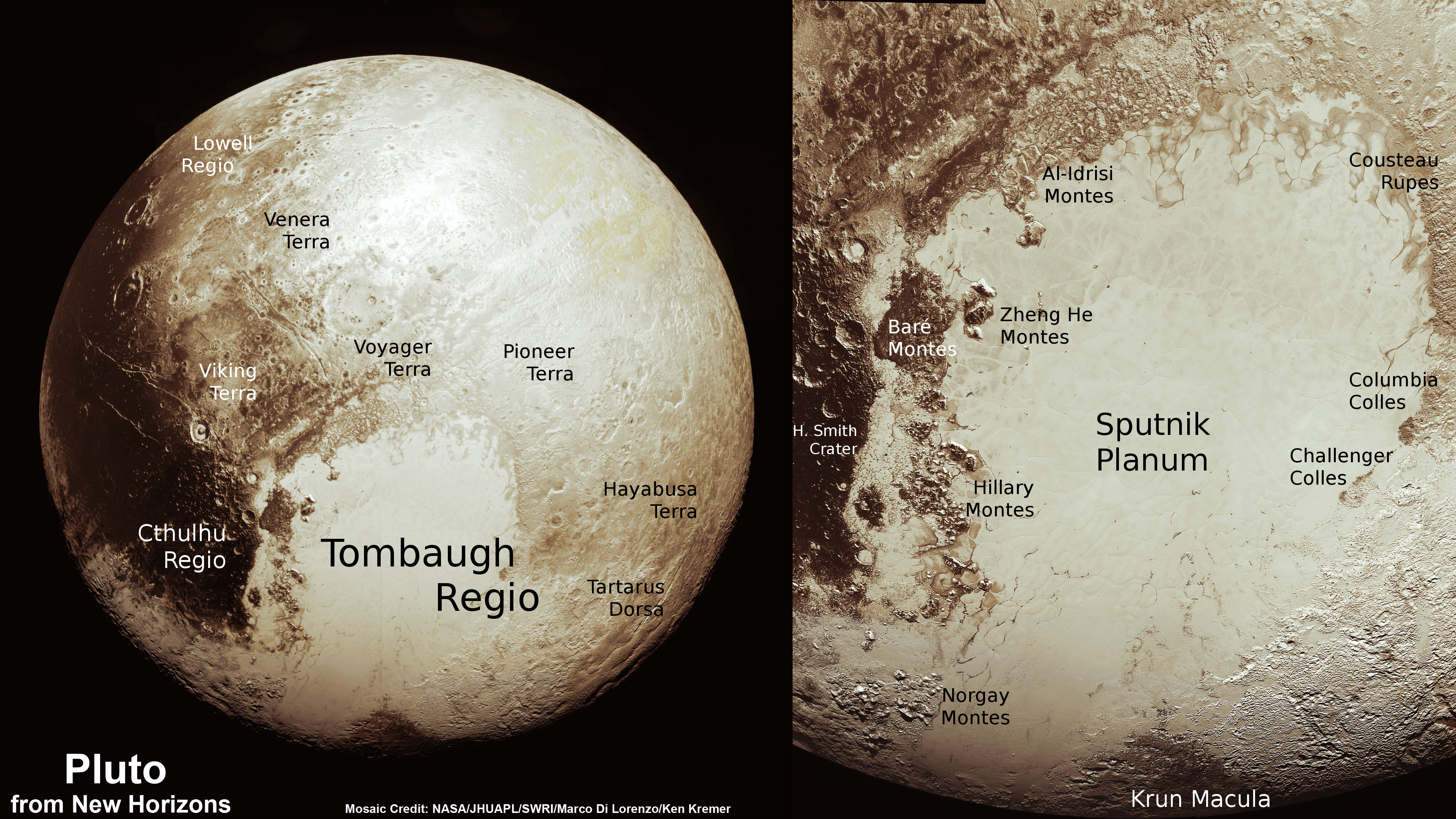
This color image of Pluto taken by NASA’s New Horizons spacecraft shows rounded and bizarrely textured mountains, informally named the Tartarus Dorsa, rise up along Pluto’s terminator and show intricate but puzzling patterns of blue-gray ridges and reddish material in between. This view, roughly 330 miles (530 kilometers) across, combines blue, red and infrared images taken by the Ralph/Multispectral Visual Imaging Camera (MVIC) on July 14, 2015, and resolves details and colors on scales as small as 0.8 miles (1.3 kilometers). Credits: NASA/JHUAPL/SWRI
Data from that priceless, once in a lifetime flyby is now trickling back to Earth.
The ‘snakeskin’ feature on Pluto’s utterly bizarre surface was unveiled to “astonished” scientists scrutinizing the latest data dump received over the past week, that included images taken by the Ralph instruments Multispectral Visual Imaging Camera (MVIC).
Features as small as 0.8 miles (1.3 kilometers) are resolved in detail.
The MVIC image stretches about 330 miles (530 kilometers) across the ‘snakeskin’ like landscape composed of rounded and bizarrely textured mountains that are informally named Tartarus Dorsa and that borders the bodies day-night terminator.
It shows intricate patterns of blue-gray ridges and reddish material in between that are puzzling researchers.
“It’s a unique and perplexing landscape stretching over hundreds of miles,” said William McKinnon, New Horizons Geology, Geophysics and Imaging (GGI) team deputy lead from Washington University in St. Louis.
“It looks more like tree bark or dragon scales than geology. This’ll really take time to figure out; maybe it’s some combination of internal tectonic forces and ice sublimation driven by Pluto’s faint sunlight.”
The Ralph/MVIC image is actually a composite of blue, red and infrared images.
The image of Tartarus Dorsa reveals a “multitude of previously unseen topographic and compositional details. It captures a vast rippling landscape of strange, aligned linear ridges that has astonished New Horizons team members,” say officials.
NASA’s New Horizons spacecraft captured this high-resolution enhanced color view of Pluto on July 14, 2015. The image combines blue, red and infrared images taken by the Ralph/Multispectral Visual Imaging Camera (MVIC). Pluto’s surface sports a remarkable range of subtle colors, enhanced in this view to a rainbow of pale blues, yellows, oranges, and deep reds. Many landforms have their own distinct colors, telling a complex geological and climatological story that scientists have only just begun to decode. The image resolves details and colors on scales as small as 0.8 miles (1.3 kilometers). The viewer is encouraged to zoom in on the image on a larger screen to fully appreciate the complexity of Pluto’s surface features. Credit: NASA/JHUAPL/SwRI
Another wider angle global view of Pluto downlinked on Sept. 19 shows a new “extended color” view of Pluto with an the extraordinarily rich color palette of the planet.
“We used MVIC’s infrared channel to extend our spectral view of Pluto,” said John Spencer, a GGI deputy lead from Southwest Research Institute (SwRI) in Boulder, Colorado.
“Pluto’s surface colors were enhanced in this view to reveal subtle details in a rainbow of pale blues, yellows, oranges, and deep reds. Many landforms have their own distinct colors, telling a wonderfully complex geological and climatological story that we have only just begun to decode.”
The image resolves details and colors on scales as small as 0.8 miles (1.3 kilometers).
High-resolution images of Pluto taken by NASA’s New Horizons spacecraft just before closest approach on July 14, 2015, reveal features as small as 270 yards (250 meters) across, from craters to faulted mountain blocks, to the textured surface of the vast basin informally called Sputnik Planum. Enhanced color has been added from the global color image. This image is about 330 miles (530 kilometers) across. For optimal viewing, zoom in on the image on a larger screen. Credits: NASA/JHUAPL/SWRI
Beyond MVIC, additional new images taken by New Horizons’ narrow-angle Long Range Reconnaissance Imager (LORRI) during the July 14 were downlinked on Sept. 20.
They focus on the Sputnik Planum ice plains on the left side of the famous heart shaped Tombaugh Regio feature and are the highest resolution yet – as seen below. The team added color based on the global MVIC map shown above.
High-resolution images of Pluto taken by NASA’s New Horizons spacecraft just before closest approach on July 14, 2015, are the sharpest images to date of Pluto’s varied terrain—revealing details down to scales of 270 meters. In this 75-mile (120-kilometer) section of the taken from a larger, high-resolution mosaic, the textured surface of the plain surrounds two isolated ice mountains. Credits: NASA/JHUAPL/SWRI
Barely 5 or 6 percent of the 50 gigabits of data captured by New Horizons has been received by ground stations back on Earth.
“With these just-downlinked images and maps, we’ve turned a new page in the study of Pluto beginning to reveal the planet at high resolution in both color and composition,” added New Horizons Principal Investigator Alan Stern, of SwRI.
“I wish Pluto’s discoverer Clyde Tombaugh had lived to see this day.”
Stern says it will take about a year for all the data to get back. Thus bountiful new discoveries are on tap.
This new global mosaic view of Pluto was created from the latest high-resolution images to be downlinked from NASA’s New Horizons spacecraft and released on Sept. 11, 2015. The images were taken as New Horizons flew past Pluto on July 14, 2015, from a distance of 50,000 miles (80,000 kilometers). This mosaic was stitched from over two dozen raw images captured by the LORRI imager and colorized. Right side mosaic comprises twelve highest resolution views of Tombaugh Regio heart shaped feature and shows objects as small as 0.5 miles (0.8 kilometers) in size. Credits: NASA/Johns Hopkins University Applied Physics Laboratory/Southwest Research Institute/ Ken Kremer/kenkremer.com/Marco Di Lorenzo
Stay tuned here for Ken’s continuing Earth and planetary science and human spaceflight news.
Just 15 minutes after its closest approach to Pluto on July 14, 2015, NASA’s New Horizons spacecraft looked back toward the sun and captured this near-sunset view of the rugged, icy mountains and flat ice plains extending to Pluto’s horizon – shown in this colorized rendition. The smooth expanse of the informally named icy plain Sputnik Planum (right) is flanked to the west (left) by rugged mountains up to 11,000 feet (3,500 meters) high, including the informally named Norgay Montes in the foreground and Hillary Montes on the skyline. To the right, east of Sputnik, rougher terrain is cut by apparent glaciers. The backlighting highlights more than a dozen layers of haze in Pluto’s tenuous but distended atmosphere. The image was taken from a distance of 11,000 miles (18,000 kilometers) to Pluto; the scene is 780 miles (1,250 kilometers) wide. Credit: NASA/Johns Hopkins University Applied Physics Laboratory/Southwest Research Institute. Colorized/Annotated: Marco Di Lorenzo/Ken Kremer/kenkremer.com
This schlieren image of a T-38C was captured using the patent-pending BOSCO technique and then processed with NASA-developed code to reveal shock wave structures.
Credit: NASA.
NASA is using a 150-year-old photographic technique with a few 21st century tweaks to capture unique and stunning images of the shockwaves created by supersonic aircraft.
Called schlieren imagery, the technique can be used to visualize supersonic airflow with full-scale aircraft in flight. Usually, this can only be done in wind tunnels using scale models, but being able to study real-sized aircraft flying through Earth’s atmosphere provides better results, and can help engineers design better and quieter supersonic planes.
And a side benefit is that the images are amazing and dramatic, creating a little “shock” and awe.
This schlieren image dramatically displays the shock wave of a supersonic jet flying over the Mojave Desert. Researchers used NASA-developed image processing software to remove the desert background, then combined and averaged multiple frames to produce a clear picture of the shock waves. Credit: NASA.
Earlier this year, NASA released some schlieren imagery taken with a high-speed camera mounted on the underside of a NASA Beechcraft B200 King Air, which captured images at 109 frames per second while a supersonic aircraft passed several thousand feet underneath over a speckled dessert floor. Special image processing software was used to remove the desert background, then combine and average multiple frames, which produces a clear picture of the shock waves. This is called air-to-air schlieren.
“Air-to-air schlieren is an important flight-test technique for locating and characterizing, with high spatial resolution, shock waves emanating from supersonic vehicles,” said Dan Banks, the principal investigator on the project, being done at NASA’s Armstrong Flight Research Center at Edwards Air Force Base. “It allows us to see the shock wave geometry in the real atmosphere as the target aircraft flies through temperature and humidity gradients that cannot be duplicated in wind tunnels.”
But now they’ve started using a technique that might provide better results: using the Sun and Moon as a lit background. This backlit method is called Background-Oriented Schlieren using Celestial Objects, or BOSCO.
The speckled background or a bright light source is used for visualizing aerodynamic flow phenomena generated by aircraft or other objects passing between the camera and the backdrop.
This schlieren image of shock waves created by a T-38C in supersonic flight was captured using the sun’s edge as a light source and then processed using NASA-developed code. Credit: NASA.
NASA explains the technique:
“Flow visualization is one of the fundamental tools of aeronautics research, and schlieren photography has been used for many years to visualize air density gradients caused by aerodynamic flow. Traditionally, this method has required complex and precisely aligned optics as well as a bright light source. Refracted light rays revealed the intensity of air density gradients around the test object, usually a model in a wind tunnel. Capturing schlieren images of a full-scale aircraft in flight was even more challenging due to the need for precise alignment of the plane with the camera and the sun.”
Then, there are variations on this technique. One recent demonstration used Calcium-K Eclipse Background Oriented Schlieren (CaKEBOS). According to Armstrong principal investigator Michael Hill, CaKEBOS was a proof of concept test to see how effectively the Sun could be used for background oriented schlieren photography.
Using the solar disk as a backdrop, its details revealed by a calcium-K optical filter, researchers processed this image to reveal shock waves created by a supersonic T-38C. Credit: NASA.
“Using a celestial object like the sun for a background has a lot of advantages when photographing a flying aircraft,” Hill said. “With the imaging system on the ground, the target aircraft can be at any altitude as long as it is far enough away to be in focus.”
Researchers found the ground-based method to be significantly more economical than air-to-air methods, since you don’t have to have a second aircraft carrying specially mounted camera equipment. The team said they can use off-the-shelf equipment.
Schlieren imagery was originally invented in 1864 by German physicist August Toepler.
Find out more about the air-to-air technique here and the BOSCO techniques here.
This time-lapse color panorama from China’s Chang’e-3 lander shows the Yutu rover at two different positions during its trek over the Moon’s surface at its landing site from Dec. 15-18, 2013. This view was taken from the 360-degree panorama. Credit: CNSA/Chinanews/Ken Kremer/Marco Di Lorenzo. See our complete Yutu timelapse pano at NASA APOD Feb. 3, 2014: http://apod.nasa.gov/apod/ap140203.htm
China plans lunar far side landing with hardware similar to Chang’e-3 lander
This time-lapse color panorama from China’s Chang’e-3 lander shows the Yutu rover at two different positions during its trek over the Moon’s surface at its landing site from Dec. 15-18, 2013. This view was taken from the 360-degree panorama. Credit: CNSA/Chinanews/Ken Kremer/Marco Di Lorenzo.
See our complete Yutu timelapse pano at NASA APOD Feb. 3, 2014: [/caption]
Chinese scientists plan to carry out the highly complex lunar landing mission using a near identical back up to the nations highly successful Chang’e-3 rover and lander – which touched down in December 2013.
If successful, China would become the first country to accomplish the history making task of a Lunar far side landing.
“The mission will be carried out by Chang’e-4, a backup probe for Chang’e-3, and is slated to be launched before 2020,” said Zou Yongliao from the moon exploration department under the Chinese Academy of Sciences, according to a recent report in China’s government owned Xinhua news agency.
Zou made the remarks at a deep-space exploration forum in China.
“China will be the first to complete the task if it is successful,” said Zou.
Chinese space scientists have been evaluating how best to utilize the Chang’e-4 hardware, built as a backup to Chang’e-3, ever since China’s successful inaugural soft landing on the Moon was accomplished by Chang’e-3 in December 2013 with the mothership lander and piggybacked Yutu lunar rover.
Chang’e-3/Yutu Timelapse Color Panorama This newly expanded timelapse composite view shows China’s Yutu moon rover at two positions passing by crater and heading south and away from the Chang’e-3 lunar landing site forever about a week after the Dec. 14, 2013 touchdown at Mare Imbrium. This cropped view was taken from the 360-degree timelapse panorama. See complete 360 degree landing site timelapse panorama herein and APOD Feb. 3, 2014. Chang’e-3 landers extreme ultraviolet (EUV) camera is at right, antenna at left. Credit: CNSA/Chinanews/Ken Kremer/Marco Di Lorenzo – kenkremer.com. See our complete Yutu timelapse pano at NASA APOD Feb. 3, 2014: http://apod.nasa.gov/apod/ap140203.html
Plans to launch Chang’e-4 in 2016 were eventually abandoned in favor of further evaluation.
After completing an intense 12 month study ordered by China’s government, space officials confirmed that the lunar far side landing was the wisest use of the existing space hardware.
Chang’e-4 will be modified with a larger payload.
“Chang’e-4 is very similar to Chang’e-3 in structure but can handle more payload,” said Zou.
“It will be used to study the geological conditions of the dark side of the moon.”
The moon is tidally locked with the Earth so that only one side is ever visible. But that unique characteristic makes it highly attractive to scientists who have wanted to set up telescopes and other research experiments on the lunar far side for decades.
“The far side of the moon has a clean electromagnetic environment, which provides an ideal field for low frequency radio study. If we can can place a frequency spectrograph on the far side, we can fill a void,” Zou elaborated.
China will also have to launch another lunar orbiter in the next few years to enable the Chang’e-4 lander and rover to transmit signals and science data back to Chinese mission control on Earth.
In the meantime, China already announced its desire to forge ahead with an ambitious mission to return samples from the lunar surface later this decade.
The Chinese National Space Agency (CNSA) plans to launch the Chang’e-5 lunar sample return mission in 2017 as the third step in the nations far reaching lunar exploration program.
“Chang’e-5 will achieve several breakthroughs, including automatic sampling, ascending from the moon without a launch site and an unmanned docking 400,000 kilometers above the lunar surface,” said Li Chunlai, one of the main designers of the lunar probe ground application system, accoding to Xinhua.
The first step involved a pair of highly successful lunar orbiters named Chang’e-1 and Chang’e-2 which launched in 2007 and 2010.
The second step involved the hugely successful Chang’e-3 mothership lander and piggybacked Yutu moon rover which safely touched down on the Moon at Mare Imbrium (Sea of Rains) on Dec. 14, 2013 – marking China’s first successful spacecraft landing on an extraterrestrial body in history, and chronicled extensively in my reporting here at Universe Today.
360-degree time-lapse color panorama from China’s Chang’e-3 lander. This new 360-degree time-lapse color panorama from China’s Chang’e-3 lander shows the Yutu rover at five different positions, including passing by crater and heading south and away from the Chang’e-3 lunar landing site forever during its trek over the Moon’s surface at its landing site from Dec. 15-22, 2013 during the 1st Lunar Day. Credit: CNSA/Chinanews/Ken Kremer/Marco Di Lorenzo – kenkremer.com. See our Yutu timelapse pano at NASA APOD Feb. 3, 2014: http://apod.nasa.gov/apod/ap140203.html
See above and herein our time-lapse photo mosaics showing China’s Yutu rover dramatically trundling across the Moon’s stark gray terrain in the first weeks after she rolled all six wheels onto the desolate lunar plains.
The complete time-lapse mosaic shows Yutu at three different positions trekking around the landing site, and gives a real sense of how it maneuvered around on its 1st Lunar Day.
The 360 degree panoramic mosaic was created by the imaging team of scientists Ken Kremer and Marco Di Lorenzo from images captured by the color camera aboard the Chang’e-3 lander and was featured at Astronomy Picture of the Day (APOD) on Feb. 3, 2014.
Chang’e-3 and Yutu landed on a thick deposit of volcanic material.
Mosaic of the Chang’e-3 moon lander and the lunar surface taken by the camera on China’s Yutu moon rover from a position south of the lander during Lunar Day 3. Note the landing ramp and rover tracks at left. Credit: CNSA/SASTIND/Xinhua/Marco Di Lorenzo/Ken Kremer
China is only the 3rd country in the world to successfully soft land a spacecraft on Earth’s nearest neighbor after the United States and the Soviet Union.
Stay tuned here for Ken’s continuing Earth and planetary science and human spaceflight news.
This new global mosaic view of Pluto was created from the latest high-resolution images to be downlinked from NASA’s New Horizons spacecraft and released on Sept. 11, 2015. The images were taken as New Horizons flew past Pluto on July 14, 2015, from a distance of 50,000 miles (80,000 kilometers). This mosaic was stitched from over two dozen raw images captured by the LORRI imager and colorized. Right side mosaic comprises twelve highest resolution views of Tombaugh Regio heart shaped feature and shows objects as small as 0.5 miles (0.8 kilometers) in size. Credits: NASA/Johns Hopkins University Applied Physics Laboratory/Southwest Research Institute/ Ken Kremer/kenkremer.com/Marco Di Lorenzo
Video caption: This animation of LORRI (Long Range Reconnaissance Imager) images begins with a low-altitude look at the informally named Norgay Montes, flies northward over the boundary between informally named Sputnik Planum and Cthulhu Regio, turns, and drifts slowly east above Pluto’s heart shaped Tombaugh Regio feature. It then rises about 10 times higher in altitude as NASA’s New Horizons flew closest to Pluto on July 14, 2015. Credit: NASA/JHUAPL/SwRI/Stuart Robbins. See additional high resolution global Pluto and Tombaugh Regio mosaics below
Imagine yourself as a once in a lifetime Plutonian tourist sailing along in a spartan spaceship and looking out the windows to breathtaking alien landscapes with cameras snapping away.
Now for the first time in human history, you can embark on a heretofore unimaginable flyover tour over Pluto – the most distant planetary system yet explored by an emissary from Earth, thanks to the team propelling NASA’s New Horizons spacecraft to the far flung reaches of our Solar System.
Just click on the video above and take the astounding aerial flyover tour above Pluto’s huge heart and the icy worlds wondrous array of tectonically active flow plains and majestic mountain ranges towering kilometers skyward to its thin hazy atmosphere.
The animation is a gift to humanity as seen from the perspective of the New Horizons probe as it flew past Pluto on July 14, 2015 at a distance of 50,000 miles (80,000 kilometers).
The new flyover video beautifully melds “art and science” – and is the brainchild of Stuart Robbins, a New Horizons research scientist at the Southwest Research Institute in Boulder, Colorado.
“I have used the latest images to produce an animation that shows what it might be like to take an aerial tour through Pluto’s thin atmosphere and soar above the surface that New Horizons explored,” Robbins explained in a blog posting.
The flyover animation is based on a stitched together mosaic of New Horizons images that were then rendered onto a sphere of Pluto. The animation and spherical mosaic were created by New Horizons team members using the initial batch of images taken by the LORRI (Long Range Reconnaissance Imager) camera and downloaded from the spacecraft as of Sept. 11, 2015.
“The mosaic …. provides an incredibly accurate portrayal of Pluto’s surface. It showcases …. the huge variety of terrain types that we see on Pluto.”
The flyover begins low over the heart shaped region of Pluto informally named Tombaugh Regio by the New Horizons team. The LORRI images at the starting point over the Norgay Montes mountain range have a resolution up to 400 meters per pixel at a altitude of only about 120 miles (200 kilometers). The resolution then changes to about 800 meters per pixel.
The animation concludes with images of approximately 2.1 kilometers per pixel as the apparent altitude increases tenfold to about 1,500 miles (2,500 kilometers) as viewers perspective changes from an up close view to one revealing Pluto’s disk rapidly growing to show about 80% of the hemisphere New Horizons flew closest to on July 14, 2015.
Here is Robbins explanation of the Plutonian terrain visible during your tourists eye view:
“Our tour starts low over the informally named Norgay Montes at a height of about 120 miles (200 kilometers). These jagged mountains rise almost 2 miles (3 kilometers) from the surrounding surface.”
“We head north over Sputnik Planum (bright area to the left) and Cthulhu Regio (dark area to the right). While Sputnik Planum is smooth at this pixel scale, it’s in marked contrast to Cthulhu Regio which has many large impact craters that indicate the Regio is much older. The differences in brightness are some of the largest natural brightness variations of any object in the solar system.”
“Our view steadily rises to a height of about 150 miles (240 kilometers) and turns to look east. From this point, we drift slowly to the east, with Pluto’s north pole to the left, Tombaugh Regio filling much of the middle of the view, and older, more cratered areas standing out in marked contrast to the younger glaciers of the “heart’s” left lobe, Sputnik Planum.”
“As we continue to fly, our flight path rises to more than 1,500 miles (2,500 kilometers) with the final view of most of the disk that New Horizons saw on July 14.”
Robbins role on the New Horizons science team is using the images “to map craters across the surfaces of Pluto and its largest moon, Charon, to understand the population of impactors from the Kuiper Belt striking Pluto and Charon.”
To see and study the whole disk of Pluto and the highest resolution view of the “heart” check out our global Pluto and Tombaugh Regio mosaics generated from raw images captured by New Horizons’ Long Range Reconnaissance Imager (LORRI) and stitched together by the image processing team of Marco Di Lorenzo and Ken Kremer.
New Horizon’s unveiled Pluto as a surprisingly vibrant and geologically active “icy world of wonders” as it barreled past the Pluto-Charon double planet system on July 14 at over 31,000 mph (49,600 kph) and collected unprecedented high resolution imagery and spectral measurements of the utterly alien worlds.
What are Pluto’s newly discovered plains and mountains composed of?
“The plains are made of nitrogen. But nitrogen is too soft a material to build mountains out of, even in Pluto’s weak gravity,” says New Horizons Principal Investigator Alan Stern of the Southwest Research Institute, Boulder, Colorado.
“So the mountains must be made of something else stronger. Rock and water ice are the two most likely possibilities. But they are most likely water ice.”
Here’s our colorized and annotated version of the recently released backlit view of Pluto taken 15 minutes after closest approach as New Horizons spacecraft looked back toward the sun and captured a near-sunset view of the rugged, icy mountains and flat ice plains extending to Pluto’s horizon.
Just 15 minutes after its closest approach to Pluto on July 14, 2015, NASA’s New Horizons spacecraft looked back toward the sun and captured this near-sunset view of the rugged, icy mountains and flat ice plains extending to Pluto’s horizon – shown in this colorized rendition. The smooth expanse of the informally named icy plain Sputnik Planum (right) is flanked to the west (left) by rugged mountains up to 11,000 feet (3,500 meters) high, including the informally named Norgay Montes in the foreground and Hillary Montes on the skyline. To the right, east of Sputnik, rougher terrain is cut by apparent glaciers. The backlighting highlights more than a dozen layers of haze in Pluto’s tenuous but distended atmosphere. The image was taken from a distance of 11,000 miles (18,000 kilometers) to Pluto; the scene is 780 miles (1,250 kilometers) wide. Credit: NASA/Johns Hopkins University Applied Physics Laboratory/Southwest Research Institute. Colorized/Annotated: Marco Di Lorenzo/Ken Kremer/kenkremer.com
Since the flyby, the team has been busy analyzing the science data returned thus far and “making some discoveries” says Stern.
“Pluto is showing us a diversity of landforms and complexity of processes that rival anything we’ve seen in the solar system.”
“If an artist had painted this Pluto before our flyby, I probably would have called it over the top — but that’s what is actually there.”
New Horizons gathered about 50 gigabits of data as it hurtled past Pluto, its largest moon Charon and four smaller moons.
New Horizons also discovered that Pluto is the biggest object in the outer solar system and thus the ‘King of the Kuiper Belt’.
The Kuiper Belt comprises the third and outermost region of worlds in our solar system.
Only about 5 to 6 percent has been downlinked to Earth so far. Stern says it will take about a year for all the data to get back.
So expect a year of endless treats and surprises from the ‘King of the Kuiper Belt’!
This new global mosaic view of Pluto was created from the latest high-resolution images to be downlinked from NASA’s New Horizons spacecraft and released on Sept. 11, 2015. The images were taken as New Horizons flew past Pluto on July 14, 2015, from a distance of 50,000 miles (80,000 kilometers). This new mosaic was stitched from over two dozen raw images captured by the LORRI imager and colorized. Credits: NASA/Johns Hopkins University Applied Physics Laboratory/Southwest Research Institute/Marco Di Lorenzo/Ken Kremer/kenkremer.com
Watch for Ken’s continuing coverage of the Pluto flyby. He was onsite reporting live on the flyby and media briefings for Universe Today from the Johns Hopkins University Applied Physics Laboratory (APL), in Laurel, Md.
Stay tuned here for Ken’s continuing Earth and planetary science and human spaceflight news.
Watched @MartianMovie on @Space_Station last night! Today working towards our #JourneyToMars during my #YearInSpace!” Credit: NASA/Scott Kelly
Video caption: ‘The Martian’ Star Matt Damon Discusses NASA’s Journey to Mars. Credit: NASA
The excitement is building for the worldwide movie premiere of ‘The Martian’ on Oct. 2.
Based on the bestselling book by Andy Weir, ‘The Martian’ tells the story of how NASA astronaut Mark Watney, played by Matt Damon, is accidentally stranded on the surface of Mars during a future manned expedition, after a sudden and unexpectedly fierce dust storm forces the rest of the crew to quickly evacuate after they believe he is dead.
In the video above, Matt Damon discusses NASA’s ongoing real life efforts focused on turning science fiction dreams into reality and sending astronauts to Mars.
Watney actually survived the storm but lost contact with NASA. The film recounts his ingenious years long struggle to survive, figure out how to tell NASA he is alive and send a rescue crew before he starves to death on a planet where nothing grows. Watney’s predicament is a survival lesson to all including NASA.
‘The Martian’ was written by Andy Weir in 2010 and has now been produced as a major Hollywood motion picture starring world famous actor Matt Damon and directed by the world famous director Ridley Scott from 20th Century Fox.
NASA’s overriding strategic goal is to send humans on a ‘Journey to Mars’ by the 2030s.
‘The Martian’ is a rather realistic portrayal of how NASA might accomplish the ‘Journey to Mars.’
“Sending people to Mars and returning them safely is the challenge of a generation,” says Damon in the video.
“The boot prints of astronauts will follow the rover tracks [of NASA’s Curiosity rover] thanks to innovations happening today.”
“NASA’s Journey to Mars begins on the International Space Station (ISS) .. where we are learning how humans can thrive over long periods without gravity.”
The current six person crew serving aboard the ISS even got a sneak preview of The Martian this past weekend!
Gleeful NASA astronaut Scott Kelly, commander of the Expedition 45 crew, just tweeted a photo of the crew watching ‘The Martian’ while soaring some 250 miles (400 kilometers) above Earth.
“Watched @MartianMovie on @Space_Station last night! Today working towards our #JourneyToMars during my #YearInSpace!” tweeted NASA astronaut Scott Kelly.
Kelly comprises one half of the first ever ‘1 Year ISS Crew’ along with Russian cosmonaut Mikhail Kornienko, aimed at determining the long term physical and psychological effects on the human body of people living and working in the weightlessness of space.
The 1 Year ISS mission is an important data gathering milestone on the human road to Mars since the round trip time to the Red Planet and back will take approximately 3 years or more.
The first unmanned test flight of SLS/Orion is slated for Nov. 2018. The first manned flight could occur between 2021 and 2023 – read my new report here.
“The Journey to Mars will forever change our history books … and expand our human presence deeper into the solar system,” says Damon.
THE MARTIAN features a star studded cast that includes Matt Damon, Jessica Chastain, Kristen Wiig, Kate Mara, Michael Pena, Jeff Daniels, Chiwetel Ejiofor, and Donald Glover.
Matt Damon stars as NASA astronaut Mark Watney in ‘The Martian.’ Credit: 20th Century Fox
“NASA has endorsed “The Martian’” Jim Green, NASA’s Director of Planetary Sciences, told Universe Today. Green served as technical consultant on the film.
I have read the book (I’m a professional chemist) and highly recommend it to everyone.
The Martian is all about how Watney uses his botany and chemistry skills to “Science the Sh.. out of it” to grow food and survive.
Learning how to live of the land will be a key hurdle towards enabling long term space voyages.
Kelly and his ISS cremates took a big first step towards putting that theory into practice when they recently grew, harvested and ate the first space grown NASA lettuce on the ISS using the Veggie experimental rack – detailed in my recent story here.
NASA Astronauts Kjell Lindgren (center) and Scott Kelly (right) and Kimiya Yui (left) of Japan consume space grown food for the first time ever, from the Veggie plant growth system on the International Space Station. Credit: NASA TV
Here’s the second official trailer of “The Martian:
Stay tuned here for Ken’s continuing Earth and planetary science and human spaceflight news.
Veggie demonstration apparatus growing red romaine lettuce under LED lights in the Space Station Processing Facility at NASA’s Kennedy Space Center. Credit: Ken Kremer/kenkremer.com
Rendering of the ULA Vulcan rocket blasting off. United Launch Alliance (ULA) next generation rocket is set to make its debut flight in 2019. Credit: ULA
Aerojet Rocketdyne, which supplies critical rocket engines powering ULA’s fleet of Atlas and Delta rockets, recently made an unsolicited offer to buy ULA for approximately $2 Billion in cash, as Universe Today reported last week.
The Vulcan is planned to replace all of ULA’s existing rockets – which are significantly more costly than those from rival launch provider SpaceX, founded by billionaire entrepreneur Elon Musk.
Boeing never “seriously entertained” the Aerojet-Rocketdyne buyout offer, Universe Today confirmed with Boeing spokesperson Cindy Anderson.
Meanwhile in stark contrast to Boeing, Lockheed Martin has “no comment” regarding the Aerojet-Rocketdyne offer to buy ULA, Universe Today confirmed with Lockheed Martin Director External Communications Matt Kramer.
Furthermore Lockheed Martin is not only noncommittal about the future of ULA but is also “currently assessing our options” concerning the development of ULA’s Vulcan rocket, Kramer told me.
“With regard to reports of an unsolicited proposal for ULA, it is not something we seriously entertained for a number of reasons,” Boeing spokesperson Anderson told Universe Today.
“Regarding Aerojet and ULA, as a matter of policy Lockheed Martin does not have a comment,” Lockheed Martin spokesman Kramer told Universe Today.
Vulcan – United Launch Alliance (ULA) next generation rocket is set to make its debut flight in 2019. Credit: ULA
ULA was formed in 2006 as a 50:50 joint venture between Lockheed Martin and Boeing that combined their existing expendable rocket fleet families – the Atlas V and Delta IV – under one roof.
Who owns ULA is indeed of significance to all Americans – although most have never head of the company – because ULA holds a virtual monopoly on launches of vital US government national security payloads and the nation’s most critical super secret spy satellites that safeguard our national defense 24/7. ULA’s rocket fleet also launched scores of NASA’s most valuable science satellites including the Curiosity Mars rover, Dawn and New Horizons Pluto planetary probe.
Since 2006 ULA has enjoyed phenomenal launch success with its venerable fleet of Atlas V and Delta IV rockets.
“ULA is a huge part of our strategic portfolio going forward along with our satellites and manned space business. This bid we’ve really not spent much time on it at all because we’re focusing on a totally different direction,” said Chris Chadwick, president and chief executive of Boeing Defense, Space & Security, on Sept. 16 at the Air Force Association’s annual technology expo in National Harbor, Maryland – according to a report by Space News.
Boeing offered strong support for ULA and the Vulcan rocket.
Vulcan is ULA’s next generation rocket to space that can propel payloads to low Earth orbit as well as throughout the solar system – including Pluto. It is slated for an inaugural liftoff in 2019.
Vulcan’s continued development is being funded by Lockheed Martin and Boeing, but only on a quarterly basis.
The key selling point of Vulcan is that it will be an all American built rocket and it will dramatically reduce launch costs to compete toe to toe with the SpaceX Falcon rocket family.
And there is a heated competition on which of two companies will provide the new American built first stage engine that will replace the Russian-built RD-180 that currently powers the ULA Atlas V.
Vulcan’s first stage will most likely be powered by the BE-4 engine being developed by the secretive Blue Origin aerospace firm owned by billionaire Jeff Bezos.
This week ULA announced an expanded research agreement with Blue Origin about using the BE-4.
But ULA is also evaluating the AR-1 liquid fueled engine being developed by Aerojet-Rocketdyne – the company that wants to buy ULA.
The Atlas V dependence on Russia’s RD-180’s landed at the center of controversy after Russia invaded Crimea in the spring of 2014, raising the ire of Congress and enactment of a ban on their use several years in the future.
ULA is expected to make a final decision on which first stage engine to use between Blue Origin and Aerojet-Rocketdyne, sometime in 2016.
The engine choice would clearly be impacted if Aerojet-Rocketdyne buys ULA.
Boeing for its part says they strongly support ULA and continued development of the Vulcan.
“Boeing is committed to ULA and its business, and to continued leadership in all aspects of space, as evidenced by the recent announcement of an agreement with Blue Origin,” Boeing spokesperson Anderson told me.
Lockheed Martin in complete contrast did not express any long term commitment to Vulcan and just remarked they were merely “actively evaluating continued investment,” as is their right as a stakeholder.
“We have made no long-term commitments on the funding of a new rocket, and are currently assessing our options. The board is actively evaluating continued investment in the new rocket program and will continue to do so,” Lockheed Director, External Communications Matt Kramer told Universe Today.
Another factor is that Aerojet-Rocketdyne has also sought to buy the rights to manufacture the Atlas V from ULA, which is currently planned to be retired several years after Vulcan is introduced, officials have told me.
Aerojet-Rocketdyne made a bid to buy ULA, manufacturer of the Atlas V, for approximately $2 Billion. MUOS-4 US Navy communications satellite and Atlas V rocket at pad 41 at Cape Canaveral Air Force Station, FL for launch on Sept. 2, 2015 at 5:59 a.m. EDT. Credit: Ken Kremer/kenkremer.com
The Atlas V enjoys unparalleled success. Earlier this month on Sept. 2, ULA conducted its 99th launch with the successful blastoff of an Atlas V with the MUOS-4 military communications satellite from Cape Canaveral Air Force Station for the U.S. Navy.
Starliner will eventually blastoff atop Vulcan after the Atlas V is retired in the next decade.
Lockheed provided me this update on Vulcan and ULA on Sept 21:
“Lockheed Martin is proud of ULA’s unparalleled track record of mission success, with 99 consecutive successful launches to date. We support the important role ULA plays in providing the nation with assured access to space. ULA’s Vulcan rocket takes the best performance elements of Atlas and Delta and combines them in a new system that will be superior in reliability, cost, weight, and capability. The government is working to determine its strategy for an American-made engine and future launch services. As they make those determinations we’ll adjust our strategy to make sure we’re aligned with the government’s objectives and goals.”
Stay tuned here for Ken’s continuing Earth and planetary science and human spaceflight news.
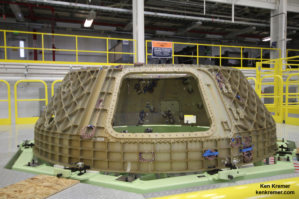
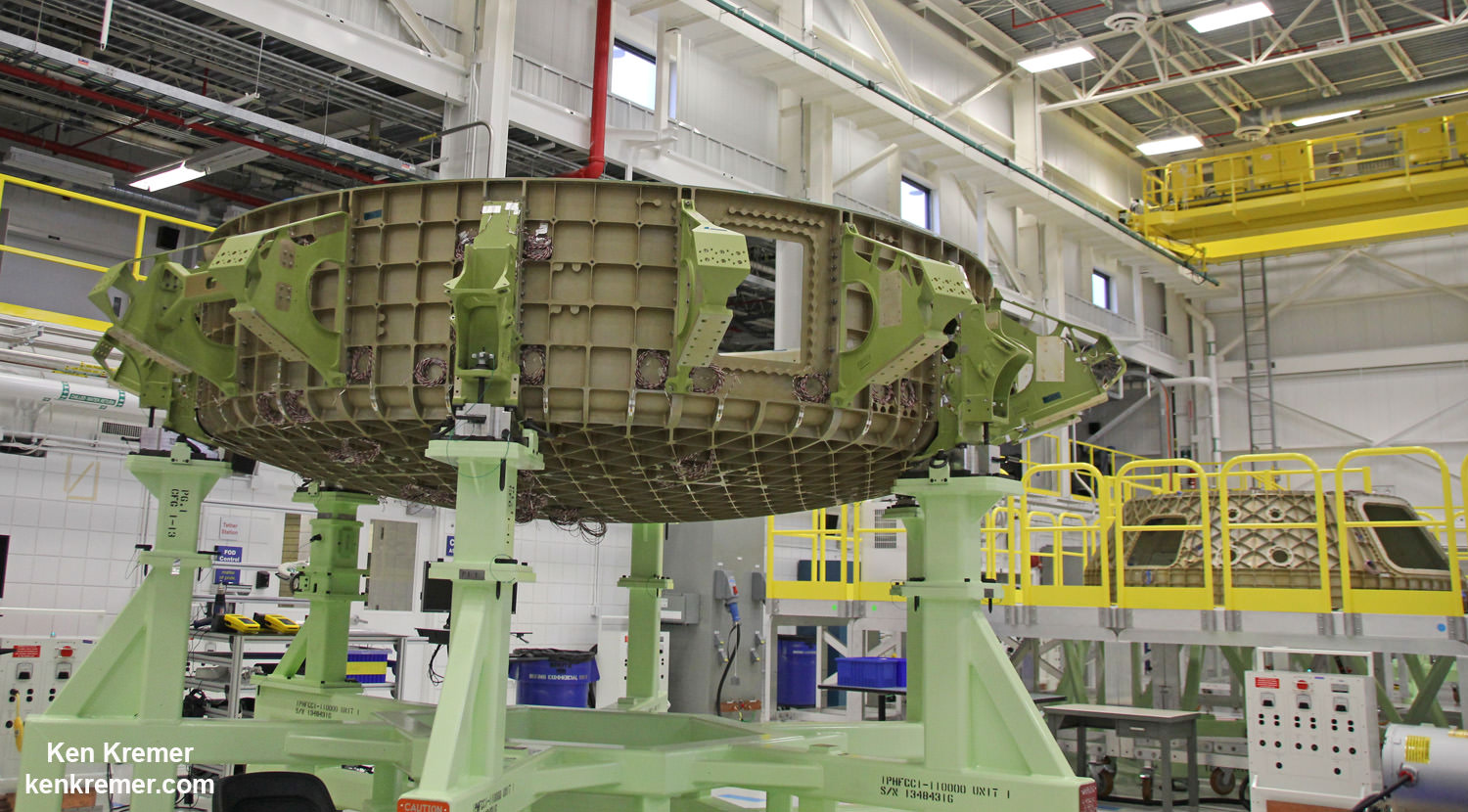
First view of upper half of the Boeing CST-100 ‘Starliner’ crewed space taxi unveiled at the Sept. 4, 2015 Grand Opening ceremony held in the totally refurbished C3PF manufacturing facility at NASA’s Kennedy Space Center. This will be part of the first Starliner crew module known as the Structural Test Article (STA) being built at Boeing’s Commercial Crew and Cargo Processing Facility (C3PF) at KSC. Credit: Ken Kremer /kenkremer.com
NASA Orion spacecraft blasts off atop 1st Space Launch System rocket in 2017 - attached to European provided service module – on an enhanced m mission to Deep Space where an asteroid could be relocated as early as 2021. Credit: NASA
The first manned flight of NASA’s Orion deep space capsule – currently under development – could slip two years from 2021 to 2023 due to a variety of budget and technical issues, top NASA officials announced on Wednesday, Sept. 16.
The potential two year postponement of Orion’s first flight with astronauts follows on the heels of the agency’s recently completed rigorous review of the programs status from a budgetary, technical, engineering, safety and risk assessment analysis of the vehicles systems and subsystems.
But Orion’s launch delay has already been condemned by some in Congress who accuse the Obama Administration of purposely shortchanging funding for the program.
Based on the budget available and all the work remaining to be accomplished, liftoff of the first Orion test flight with an astronaut crew is likely to occur “no later than April 2023,” said NASA Associate Administrator Robert Lightfoot at the Sept. 16 briefing for reporters.
NASA had been marching towards an August 2021 liftoff for the maiden crewed Orion on a test flight dubbed Exploration Mission-2 (EM-2), until Lightfoot’s announcement.
Lightfoot added that although August 2021 is still NASA’s officially targeted launch date for EM-2, achieving that early goal is not likely as a direct result of the program review.
“The team is still working toward a launch in August 2021, but have much less confidence in achieving that. But we are not changing that date for EM-2 at this time.”
“But we’re committing that we’ll be no later than April 2023.”
“It’s not a very high confidence level [on making the August 2021 launch date], I’ll tell you that, just because of the things we see historically pop up.”
Orion is being developed by NASA to send America’s astronauts on journeys venturing farther into deep space than ever before – back to the Moon first and then beyond to Asteroids, Mars and other destinations in our Solar System.
Artist’s conception of NASA’s Space Launch System with Orion crewed deep space capsule. Credit: NASA
Orion’s likely launch slip is the direct fallout from NASA’s recently completed internal program review called Key Decision Point C (KDP-C).
The KDC-P review assesses all the technological work and advancements required for launch to design, develop and manufacture Orion and that can be accomplished based on the Federal budget that will be available to carry out the program successfully.
“The KDC-P analysis just completed and decision to move forward with the Orion program is based on a 70% confidence level of success,” notes Lightfoot.
“The budget is a factor in the timing for the projection. It is based on the President’s current budget.”
“The decision commits NASA to a development cost baseline of $6.77 billion from October 2015 through the first crewed mission (EM-2) and a commitment to be ready for a launch with astronauts no later than April 2023.”
“EM-2 is a full up Orion on a human mission,” he said.
The EM-2 mission would last about 3 weeks and fly in a lunar retrograde orbit. It would carry astronauts beyond the Moon and further out into space than ever before.
Prior to EM-2, Orion’s next test flight is the uncrewed EM-1 mission targeted to launch no later than November 2018 – from Launch Complex 39-B at the Kennedy Space Center.
EM-1 will blastoff on the inaugural launch of NASA’s mammoth Space Launch System (SLS) heavy lift booster concurrently under development. The SLS will be configured in its initial 70-metric-ton (77-ton) version with a liftoff thrust of 8.4 million pounds. It will boost an unmanned Orion on an approximately three week long test flight beyond the Moon and back.
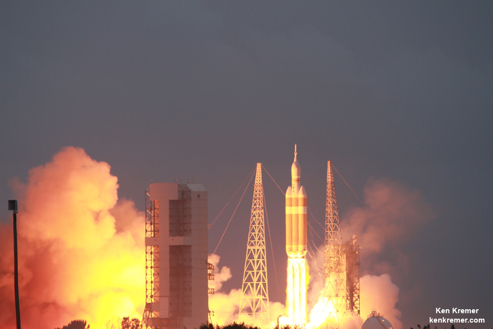
NASA’s first Orion spacecraft blasts off at 7:05 a.m. atop United Launch Alliance Delta 4 Heavy Booster at Space Launch Complex 37 (SLC-37) at Cape Canaveral Air Force Station in Florida on Dec. 5, 2014. Credit: Ken Kremer – kenkremer.com
Orion learned a lot from EFT-1 and the lessons learned are being incorporated into the EM-1 and EM-2 missions.
Among the very few changes is an alteration in the heat shield from a monolithic to a block design that will vastly simplify its manufacture.
“We are making the heat shield change as a result of what we leaned on EFT-1,” said William Gerstenmaier, the agency’s associate administrator for Human Exploration and Operations at NASA Headquarters, at the briefing.
“The Orion Program has done incredible work, progressing every day and meeting milestones to prepare for our next missions. The team will keep working toward an earlier readiness date for a first crewed flight, but will be ready no later than April 2023, and we will keep the spacecraft, rocket and ground systems moving at their own best possible paces.”
Some members of Congress and others have said that delays in the Orion and SLS program are also a direct result of funding shortfalls caused by budget cuts in the programs, and condemned the Obama Administrations 2016 NASA budget request.
In fact, the Obama Administration did request $440 million less in the 2016 NASA budget request vs. the 2015 request.
“Once again, the Obama administration is choosing to delay deep space exploration priorities such as Orion and the Space Launch System that will take U.S. astronauts to the Moon, Mars, and beyond, said Rep Lamar Smith (R-Texas) House Committee Chairman of the House Science, Space, and Technology Committee.
“While this administration has consistently cut funding for these programs and delayed their development, Congress has consistently restored funding as part of our commitment to maintaining American leadership in space,” said Chairman Smith.
“We must chart a compelling course for our nation’s space program so that we can continue to inspire future generations of scientists, engineers and explorers. I urge this administration to follow the lead of the House Science, Space, and Technology Committee’s NASA Authorization Act to fully fund NASA’s exploration programs.”
Smith added that he “has repeatedly criticized the Obama administration for failure to request adequate funding for Orion and the Space Launch System; the administration’s FY16 budget request proposed cuts of more than $440 million for the programs.”
“The House Science Committee’s NASA Authorization Act for 2016 and 2017 sought to restore $440 million to these crucial programs being developed to return U.S. astronauts to deep space destinations such as the Moon and Mars. That bill also restored funding for planetary science accounts that have been responsible for missions such as the recent Pluto fly-by, and provided full funding for the other space exploration programs such as Commercial Crew and Commercial Cargo programs.”
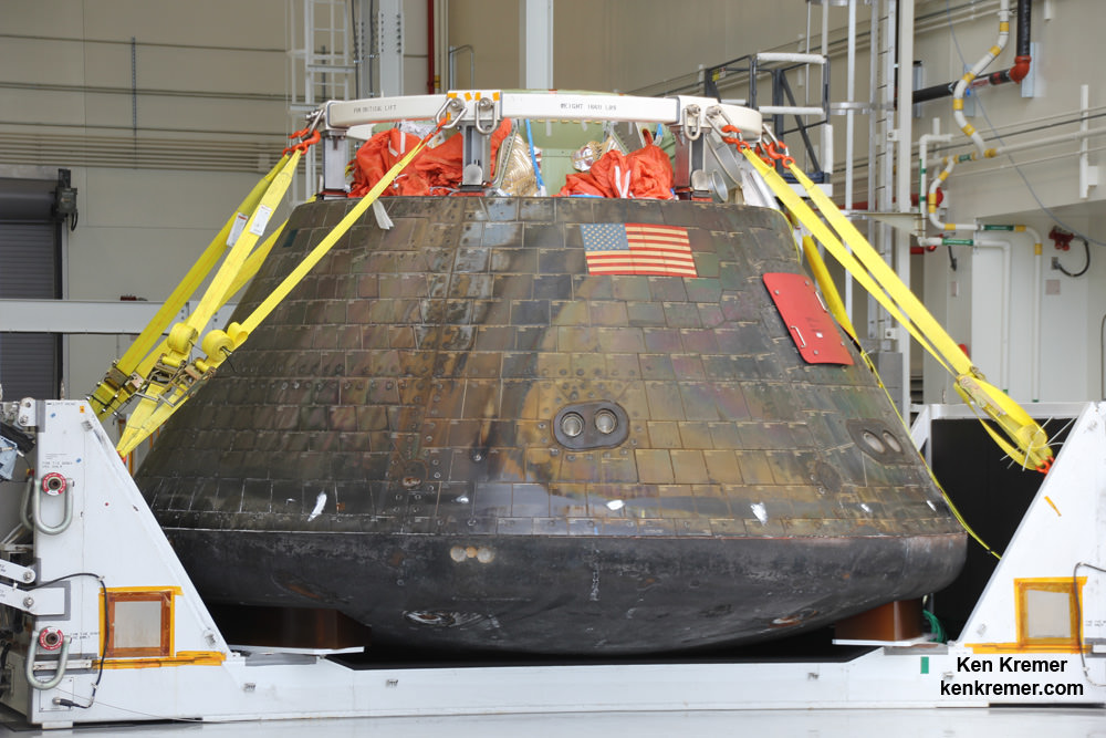
Homecoming view of NASA’s first Orion spacecraft after returning to NASA’s Kennedy Space Center in Florida on Dec. 19, 2014 after successful blastoff on Dec. 5, 2014. Credit: Ken Kremer – kenkremer.com
Stay tuned here for Ken’s continuing Earth and planetary science and human spaceflight news.
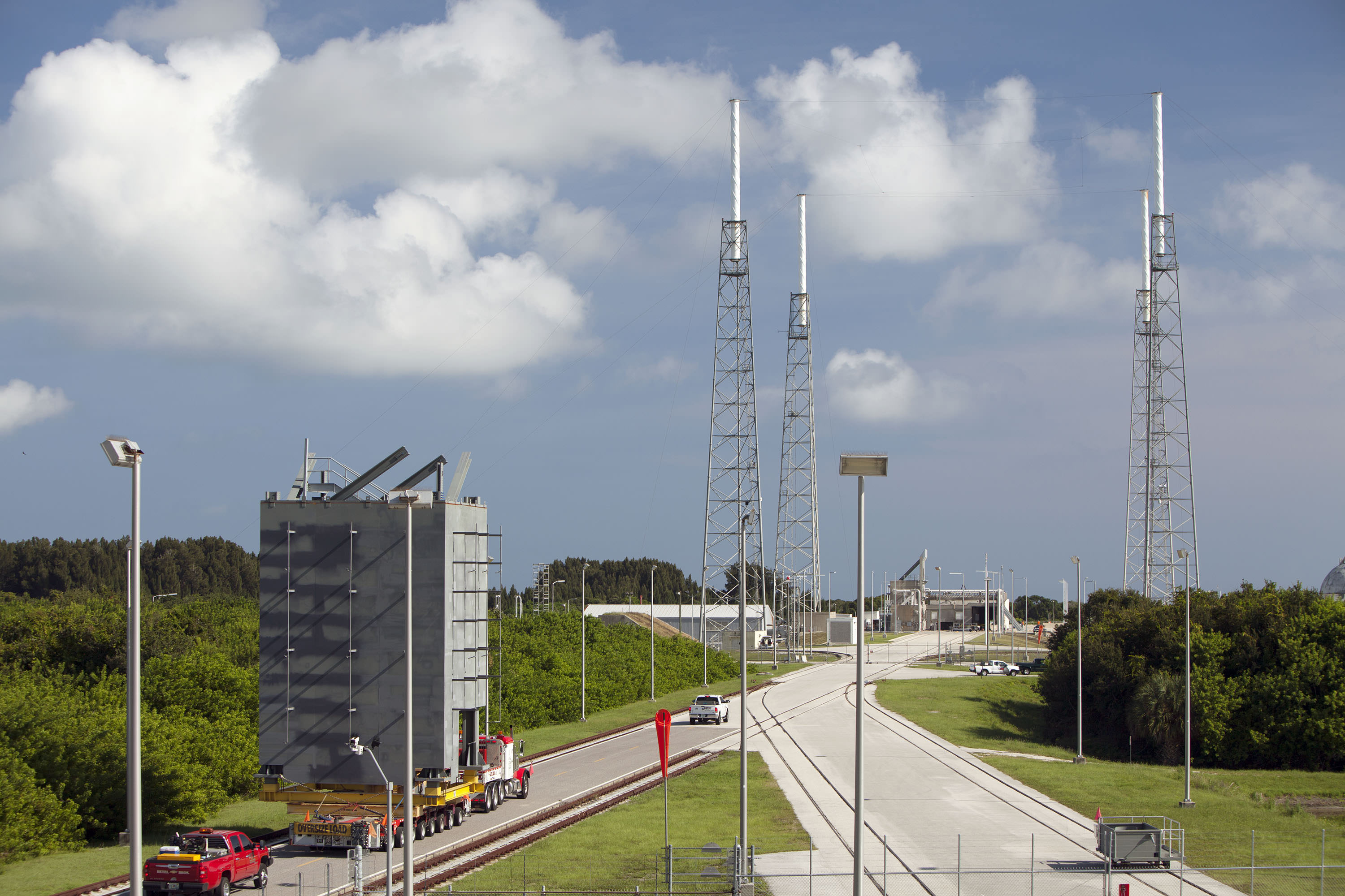
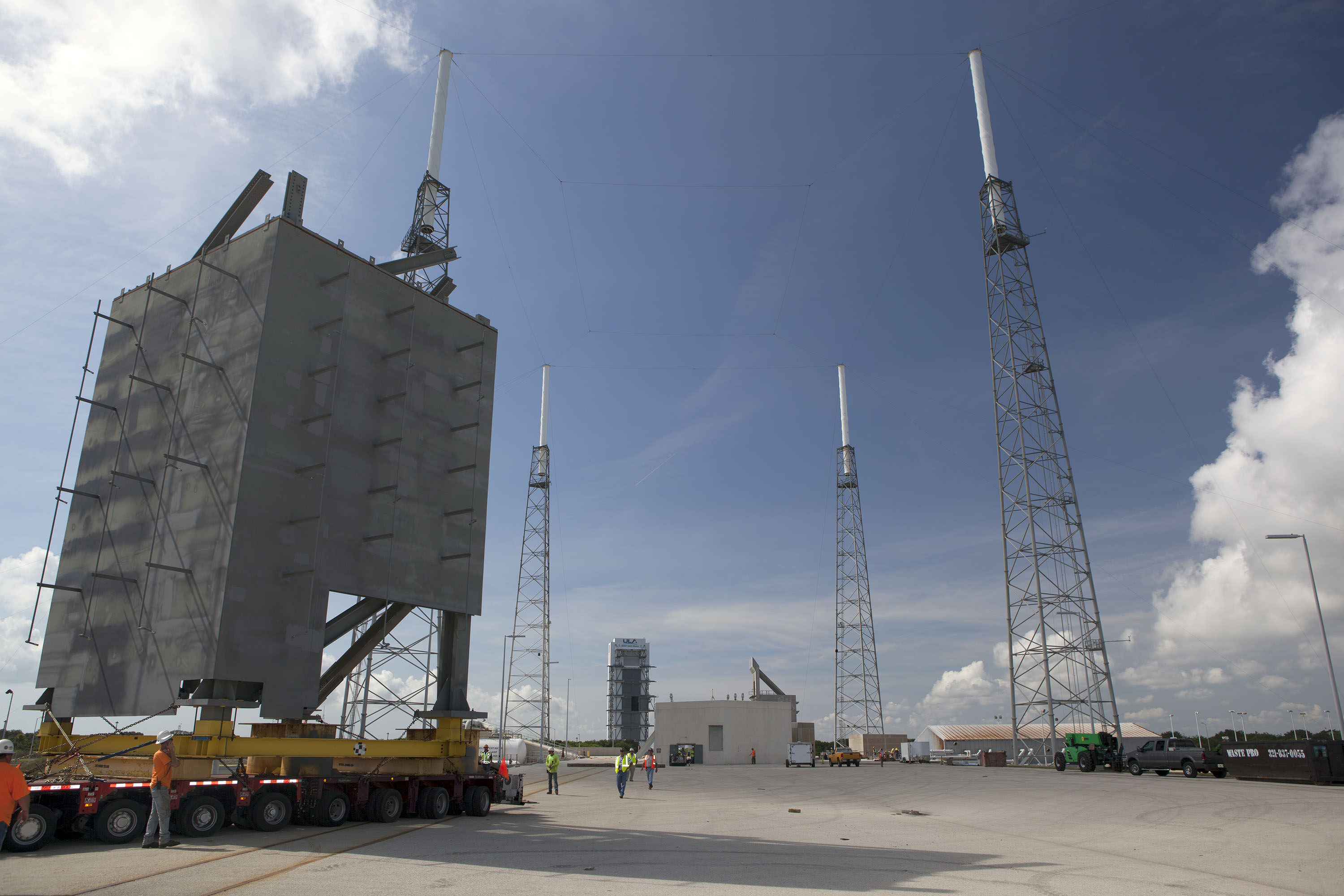
The first tier of seven tiers for Crew Access Tower is moved from its construction yard to Space Launch Complex-41 at Cape Canaveral Air Force Station in Florida. The tower will provide access at the pad for astronauts and ground support teams to the Boeing CST-100 Starliner launching atop a United Launch Alliance Atlas V rocket. Photo credit: NASA/Dmitrios Gerondidakis
The first tier of seven tiers for Crew Access Tower is moved from its construction yard to Space Launch Complex-41 at Cape Canaveral Air Force Station in Florida on Sept 9, 2015. The tower will provide access at the pad for astronauts and ground support teams to the Boeing CST-100 Starliner launching atop a United Launch Alliance Atlas V rocket. Photo credit: NASA/Dmitrios Gerondidakis Story/photos updated[/caption]
“Everything is on schedule,” Howard Biegler, ULA’s Human Launch Services Lead, told Universe Today during an exclusive interview. “The new 200-foot-tall tower structure goes up rather quickly at launch pad 41.”
The access tower essentially functions as the astronauts walkway to the stars.
“We start stacking the crew access tower [CAT] after the MUOS-4 launch and prior to the next launch after that of Morelos-3,” Beigler said in a wide ranging interview describing the intricately planned pad modifications and tower construction at the Atlas V Space Launch Complex 41 facility at Cape Canaveral.
Depending on the always tricky weather at the Cape, more than half the tower should be “installed prior to MORELOS-3’s launch on Oct. 2. The balance of the CAT will take form after the launch.”
The first tier of the new Crew Access Tower for the Boeing CST-100 Starliner arrives at Space Launch Complex-41 at Cape Canaveral Air Force Station in Florida on Sept 9, 2015. The tower will provide access at the pad for astronauts and ground support teams to the Boeing CST-100 Starliner launching atop a United Launch Alliance Atlas V rocket. Photo credit: NASA/Dmitrios Gerondidakis
The crew access tower is a critical space infrastructure element and absolutely essential for getting Americans back to space on American rockets for the first time since NASA’s shuttles were retired in 2011. That action forced our total dependence on the Russian Soyuz capsule for astronaut ridesto the space station.
Boeing was awarded a $4.2 Billion contract in September 2014 by NASA Administrator Charles Bolden to complete development and manufacture of the CST-100 space taxi under the agency’s Commercial Crew Transportation Capability (CCtCap) program and NASA’s Launch America initiative. SpaceX also received a NASA award worth $2.6 Billion to build the Crew Dragon spacecraft for launch atop the firms man-rated Falcon 9 rocket.
Starliner is a key part of NASA’s overarching strategy to send Humans on a “Journey to Mars” in the 2030s.
The tower is of modular design for ease of assembly at the always busy Atlas launch pad.
“The crew tower is comprised of seven major tiers, or segments,” Beigler explained. “The building of the tiers went right on schedule. Each tier is about 20 feet square and 28 feet tall.”
Five of the seven tiers will be installed ahead of the next Atlas launch in early October, depending on the weather which has been difficult at the Cape.
“Our plan is to get 5 tiers and a temporary roof installed prior to MORELOS-3’s launch on October 2.”
“We have been hit hard with weather and are hopeful we can gain some schedule through the weekend. The balance of the CAT will take form after the 10/2 launch with the 7th tier planned to go up on 10/13 and roof on 10/15,” Biegler explained.
The first tier of the new Crew Access Tower for the Boeing CST-100 Starliner is installed at Space Launch Complex-41 at Cape Canaveral Air Force Station in Florida where United Launch Alliance Atlas V rockets will lift Boeing Starliners into orbit. Photo credit: NASA/Dmitrios Gerondidakis
The newly named ‘Starliner’ space taxi will launch atop a newly human-rated Atlas V booster as soon as mid-2017, say NASA, ULA and Boeing officials.
But before astronauts can even climb aboard Starliner atop the Atlas rocket, ULA and Boeing first had to design, build and install a brand new tower providing access to the capsule for the crews and technicians.
Pad 41 is currently a “clean pad” with no gantry and no walkway to ‘Starliner’ because the Atlas V has only been used for unmanned missions to date.
The CST-100 ‘Starliner’ is at the forefront of ushering in the new commercial era of space flight and will completely revolutionize how we access, explore and exploit space for the benefit of all mankind.
This is the first new Crew Access Tower to be built at the Cape in decades, going back to NASA’s heyday and the Apollo moon landing era.
The tier segments were assembled about four miles down the road at the Atlas Space Operations Center on Cape Canaveral – so as not to disrupt the chock full manifest of Atlas rockets launching on a breakneck schedule for the NASA, military and commercial customers who ultimately pay the bills to keep ULA afloat and launch groundbreaking science probes and the most critical national security payloads vital to national defense.
“Each segment was outfitted with additional steel work, as well as electrical, plumbing and the staircase. Then they will be transported 3.9 miles out to the pad, one at a time on a gold hoffer and then we start erecting.”
The first two tiers were just transported out to pad 41. Installation and stacking of one tier on top of another starts in a few days.
Artist’s concept of Boeing’s CST-100 space taxi atop a human rated ULA Atlas-V rocket showing new crew access tower and arm at Space Launch Complex 41, Cape Canaveral Air Force Station, Fl. Credit: ULA/Boeing
“We are very pleased with the progress so far,” Biegler told me. “Everything is on schedule and has gone remarkably well so far. No safety or workmanship issues. It’s all gone very well.”
“The first tier is obviously the most critical [and will take a bit longer than the others to insure that everything is being done correctly]. It has to be aligned precisely over the anchor bolts on the foundation at the pad. Then it gets bolted in place.”
“After that they can be installed every couple of days, maybe every three days or so. The pieces of the tower will go up quickly.”
Artist’s concept of Boeing’s CST-100 space taxi atop a human rated ULA Atlas-V rocket showing new crew access tower and arm. Credit: ULA/BoeingThe steel tiers and tower are being built by Hensel Phelps under contract to ULA.
“Construction by the Hensel Phelps team started in January 2015,” Biegler said.
Erecting the entire tower is the next step. After stacking the tiers is fully completed later this year then comes structure, testing and calibration work over the next year.
“After tower buildup comes extensive work to outfit the tower with over 400 pieces of outboard steel that have to be installed. That takes much longer,” Biegler said.
“Designed with modern data systems, communications and power networks integrated and protected from blast and vibration, plus an elevator, the Crew Access Tower has been built with several features only a fully suited astronaut could appreciate, such as wider walkways, snag-free railings and corners that are easy to navigate without running into someone,” according to NASA officials.
Just like the shuttle, “the tower will also be equipped with slide wire baskets for emergency evacuation to a staged blast-resistant vehicle.”
“At the very top is the area that protects the access arm and provides the exit location for the emergency egress system. It will all be stick built from steel out at the pad,” Biegler elaborated.
The access arm with the walkway that astronauts will traverse to the Starliner capsule is also under construction. It is about 180 feet above ground.
Astronauts will ride an elevator up the tower to the access arm, and walk through it to the white room at the end to board the Starliner capsule.
“The arm along with the white room and torque tube are being fabricated in Florida. It will all be delivered to the pad sometime around next June [2016],” Biegler stated.
“We built a test stand tower for the access arm at our Oak Hill facility to facilitate the installation process. We mount the arm and the hydraulic drive system and then run it through its paces prior to its delivery to the pad.”
“The access arm – including the torque tube out to the end – is just over 40 feet in length.”
“We will integrate it off line because we don’t have a lot of time to troubleshoot out at the pad. So we will hook up all its drive systems and electronics on the test structure stand.”
“Then we will spend about 3 months testing it and verifying that everything is right. We’ll use laser lining to know it all precisely where the arm is. So that when we bring it out to the pad we will know where it is to within fractions of an inch. Obviously there will be some minor adjustments up and down.”
“That way in the end we will know that everything in the arm and the hydraulic drive system are working within our design specs.”
When the arm is finally installed on the crew access tower it will be complete, with the white room and environmental seal already attached.
“It will stow under the crew access tower, which is located west and north of the launch vehicle. The arm will swing out about 120 degrees to the crew module to gain access and was strategically picked to best fit the features and foundation at the existing pad structure.”
Tower construction takes place in between Atlas launches and pauses in the days prior to launches. For example the construction team will stand down briefly just ahead of the next Atlas V launch currently slated for Oct. 2 with the Mexican governments Morelos-3 communications satellite.
The Crew Access Tower is now being erected at Pad 41 following MUOS-4 blastoff here. MUOS-4 US Navy communications satellite and Atlas V rocket at pad 41 at Cape Canaveral Air Force Station, FL for launch on Sept. 2, 2015 at 5:59 a.m. EDT. Credit: Ken Kremer/kenkremer.com
Starliners’ actual launch date totally depends on whether the US Congress provides full funding for NASA’s commercial crew program (CCP).
Thus far the Congress has totally failed at providing the requested CCP budget to adequately fund the program – already causing a 2 year delay of the first flight from 2015 to 2017.
Boeing is making great progress on manufacturing the first CST-100 Starliner.
Barely a week ago, Boeing staged the official ‘Grand Opening’ ceremony for the craft’s manufacturing facility held at the Kennedy Space Center on Friday, Sept 4. 2015 – attended by Universe Today as I reported here.
ULA has also already started assembly of the first two Atlas V rockets designated for Starliner at their rocket factory in Decatur, Alabama.
Read my earlier exclusive, in depth one-on-one interviews with Chris Ferguson – America’s last shuttle commander, who now leads Boeings’ CST-100 program; here and here.
First view of the Boeing CST-100 ‘Starliner’ crewed space taxi at the Sept. 4, 2015 Grand Opening ceremony held in the totally refurbished C3PF manufacturing facility at NASA’s Kennedy Space Center. These are the upper and lower segments of the first Starliner crew module known as the Structural Test Article (STA) being built at Boeing’s Commercial Crew and Cargo Processing Facility (C3PF) at KSC. Credit: Ken Kremer /kenkremer.com
Stay tuned here for Ken’s continuing Earth and planetary science and human spaceflight news.
This new global mosaic view of Pluto was created from the latest high-resolution images to be downlinked from NASA’s New Horizons spacecraft and released on Sept. 11, 2015. The images were taken as New Horizons flew past Pluto on July 14, 2015, from a distance of 50,000 miles (80,000 kilometers). This new mosaic was stitched from over two dozen raw images captured by the LORRI imager and colorized. Credits: NASA/Johns Hopkins University Applied Physics Laboratory/Southwest Research Institute/Marco Di Lorenzo/Ken Kremer/kenkremer.com
This new global mosaic view of Pluto was created from the latest high-resolution images to be downlinked from NASA’s New Horizons spacecraft and released on Sept. 11, 2015. The images were taken as New Horizons flew past Pluto on July 14, 2015, from a distance of 50,000 miles (80,000 kilometers). This new mosaic was stitched from over two dozen raw images captured by the LORRI imager and colorized. Credits: NASA/Johns Hopkins University Applied Physics Laboratory/Southwest Research Institute/Marco Di Lorenzo/Ken Kremer/kenkremer.com
See annotated version and new hi res Tombaugh Regio mosaic below[/caption]
But because of limited bandwidth the new image data sets were stored onboard the probe until days ago when they were transmitted back to Earth and released by the New Horizons team late in the day on Friday, Sept. 11.
This best yet view of far flung Pluto comes from raw images taken as New Horizons conducted the history making first flyby past Pluto on July 14, 2015, at a distance of 50,000 miles (80,000 kilometers).
The global Pluto mosaic was generated from over two dozen raw images captured by New Horizons’ Long Range Reconnaissance Imager (LORRI) and stitched together by the image processing team of Marco Di Lorenzo and Ken Kremer.
See also our expanded hi res Tombaugh Regio mosaic below showing features as small as 0.5 miles (0.8 kilometers) in size.
After transmitting carefully selected high priority images and science measurements across over 3 billion miles (about 5 billion kilometers) of interplanetary space in the days around the history making flyby, the team elected to temporarily pause the transmission of new images for several weeks in favor of sending other data important for helping place the entire Pluto planetary system into context.
Altogether, over 50 gigabits of data were collected during the July 14 encounter and flyby periods of the highest scientific activity – which includes the most critical hours before and after the spacecrafts closest approach to Pluto, its largest moon Charon and its quartet of smaller moons.
Highest resolution mosaic of ‘Tombaugh Regio’ shows the heart-shaped region on Pluto including ice flows and plains of ‘Sputnik Planum’ (center) and icy mountain ranges of ‘Hillary Montes’ and ‘Norgay Montes.’ This new mosaic combines the eleven highest resolution images captured by NASA’s New Horizons LORRI imager during history making closest approach flyby on July 14, 2015. It shows features as small as 0.5 miles (0.8 kilometers) in size. Credit: NASA/JHUAPL/SWRI/Ken Kremer/kenkremer.com/Marco Di Lorenzo
Data from the flyby continues streaming back to Earth, but rather slowly due to limited bandwidth amounting to an average “downlink” of only about 2 kilobits per second via its two transmitters.
New Horizon’s unveiled Pluto as a surprising vibrant and geologically active “icy world of wonders” as it barreled past the Pluto-Charon double planet system on July 14 at over 31,000 mph (49,600 kph) and collected unprecedented high resolution imagery and spectral measurements of the utterly alien worlds.
Since the flyby, the team has been busy analyzing the science data returned thus far and “making some discoveries” said New Horizons Principal Investigator Alan Stern of the Southwest Research Institute, Boulder, Colorado, during the Weekly Space Hangout on Sept 11.
The team is ecstatic with all the new images and created what they call a synthetic global view of a portion of Pluto.
“We created a synthetic global mosaic view of more than a dozen frames from the LORRI camera, and wrapped it on a sphere and then projected the view as if you were suspended about a thousand miles above the planet – looking back.”
Each LORRI frame is about 400 km across.
This new mosaic of Pluto is from the latest high-resolution images sent to Earth from the New Horizons spacecraft shows what you would see if you were approximately 1,100 miles (1,800 kilometers) above Pluto’s equatorial area, looking northeast over the dark, cratered, informally named Cthulhu Regio toward the bright, smooth, expanse of icy plains informally called Sputnik Planum. The entire expanse of terrain seen in this image is 1,100 miles (1,800 kilometers) across. The images were taken as New Horizons flew past Pluto on July 14, 2015, from a distance of 50,000 miles (80,000 kilometers). Credit: NASA/Johns Hopkins University Applied Physics Laboratory/Southwest Research Institute
“It gives a breathtaking view of how diverse the geology is and also how diverse the seasonal volatile transport must be across the surface.”
“It’s just absolutely magical and breathtaking. There is a lot going on there.”
“The big bright area on the left side of the heart shaped feature is informally called Sputnik Planum after the first spacecraft – Sputnik. Surrounding the Texas sized plain are steep mountain ranges that are as tall as the Rockies in Colorado.”
What are Pluto’s plains and mountains comprised of?
“We know that the mountain ranges are not made of the same stuff as the planum, or plains. The plains are made of nitrogen. But nitrogen is too soft a material to build mountains out of, even in Pluto’s weak gravity.”
“So the mountains must be made of something else stronger. Rock and water ice are the two most likely possibilities. But they are most likely water ice, the lighter stuff. Because the rock has almost certainly sunk to the center of Pluto and the ice has floated to the top and formed the mantle and perhaps the crust of Pluto.”
“So we think the volatiles like the nitrogen, methane and carbon monoxide you see there and that shifts around with the seasons and interacts with the atmosphere – is just a veneer. It’s just a coating on the surface. And in some places its very thin and looks like it is breaking up on the margins. In other places it may be quite thick, maybe even kilometers thick.”
“We’ll see when we have more data!” exclaimed Stern.
“The data downlink will take over a year to get all the data to the ground [on Earth].”
“Over 50 gigabits of science data from the Pluto system needs to be sent back. The Pluto flyby took place on the 50th anniversary of NASA’s first flyby of Mars by Mariner IV. New Horizons dataset amounted to several thousand times more data collected compared to what Mariner IV sent back during its first flyby of Mars,” Stern elaborated.
“The surface of Pluto is every bit as complex as that of Mars,” says Jeff Moore, leader of the New Horizons Geology, Geophysics and Imaging (GGI) team at NASA’s Ames Research Center in Moffett Field, California. “The randomly jumbled mountains might be huge blocks of hard water ice floating within a vast, denser, softer deposit of frozen nitrogen within the region informally named Sputnik Planum.”
How much data has been returned so far varies by instrument.
“The average across all the entire science payload is only about 5 or 6 percent so far,” Stern explained.
“All the flyby data from the two plasma instruments – PEPSI and SWAP – and the Student Dust Counter instrument is back on the ground, because they were small datasets.”
“But less than 3% of the ALICE UV spectrometer data is back so far. And for the other imaging instruments its similar.”
“So it’s going to take about another year to send all the data back!”
This new global mosaic view of Pluto was created from the latest high-resolution images to be downlinked from NASA’s New Horizons spacecraft and released on Sept. 11, 2015. The images were taken as New Horizons flew past Pluto on July 14, 2015, from a distance of 50,000 miles (80,000 kilometers). This new mosaic was stitched from over two dozen raw images captured by the LORRI imager and colorized. Annotated with informal place names. Credits: NASA/Johns Hopkins University Applied Physics Laboratory/Southwest Research Institute/Marco Di Lorenzo/Ken Kremer/kenkremer.com
Stern informed that the team has submitted a paper to the journal Science and plans a large series of technical scientific presentations at upcoming meetings, including the Division of Planetary Sciences Meeting in Washington in November.
And New Horizons is in excellent shape to get those 50 gigabits of data back to the eagerly waiting researchers since all the spacecraft systems are operating normally.
“The spacecraft is doing very well,” said Alice Bowman, New Horizons Mission Operations Manager of the Johns Hopkins University Applied Physics Laboratory (APL), during the Weekly Space Hangout.
“It’s very healthy and we are getting back gobs of data – causing a flurry of emails among the science team.”
“It’s been a good ride and we had a good flyby of Jupiter too [along the way].”
This new global mosaic view of Pluto was created from the latest high-resolution images to be downlinked from NASA’s New Horizons spacecraft and released on Sept. 11, 2015. The images were taken as New Horizons flew past Pluto on July 14, 2015, from a distance of 50,000 miles (80,000 kilometers). This mosaic was stitched from over two dozen raw images captured by the LORRI imager and colorized. Right side mosaic comprises twelve highest resolution views of Tombaugh Regio heart shaped feature and shows objects as small as 0.5 miles (0.8 kilometers) in size. Credits: NASA/Johns Hopkins University Applied Physics Laboratory/Southwest Research Institute/ Ken Kremer/kenkremer.com/Marco Di Lorenzo
New Horizons also discovered that Pluto is the largest known body beyond Neptune – and thus reigns as the “King of the Kuiper Belt!”
As of today, Sept. 14, New Horizons is 2 months past the Pluto flyby and already over 73 million kilometers ( over 45 million miles) beyond Pluto and continuing its journey into the Kuiper Belt, the third realm of worlds in our solar system.
The science team plans to target New Horizons to fly by another much smaller Kuiper Belt Object (KBO) in 2019 after recently selecting the object dubbed PT1, for Potential Target 1, based on images taken by NASA’s Hubble Space Telescope.
“Since the flyby, we have been planning for the extended mission which we will propose to NASA next year,” Stern explained. NASA will then decide whether to approve and fund the new KBO mission proposal.
“We expect to do an engine burn for that [new KBO target] next month [in October]. The KBO flyby will take place about a billion miles beyond Pluto at about 44 AU.”
The actual flyby distance of New Horizons from the KBO is yet to be determined. Stern thinks it could perhaps be much closer, but all those details still need to be worked out.
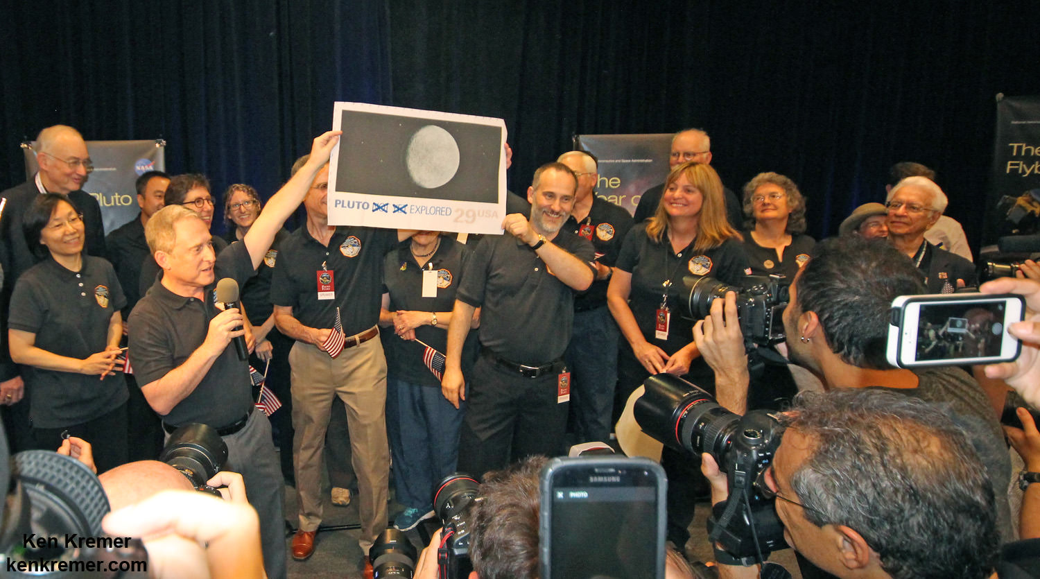
NASA Associate Administrator for the Science Mission Directorate John Grunsfeld, left, New Horizons Principal Investigator Alan Stern of Southwest Research Institute (SwRI), Boulder, CO, second from left, New Horizons Mission Operations Manager Alice Bowman of the Johns Hopkins University Applied Physics Laboratory (APL), second from right, and New Horizons Project Manager Glen Fountain of APL, right, are seen at the conclusion of a press conference after the team received confirmation from the spacecraft that it has completed the flyby of Pluto, Tuesday, July 14, 2015 at the Johns Hopkins University Applied Physics Laboratory (APL) in Laurel, Maryland. Credit: Ken Kremer/kenkremer.com
Watch for Ken’s continuing coverage of the Pluto flyby. He was onsite reporting live on the flyby and media briefings for Universe Today from the Johns Hopkins University Applied Physics Laboratory (APL), in Laurel, Md.
Stay tuned here for Ken’s continuing Earth and planetary science and human spaceflight news.
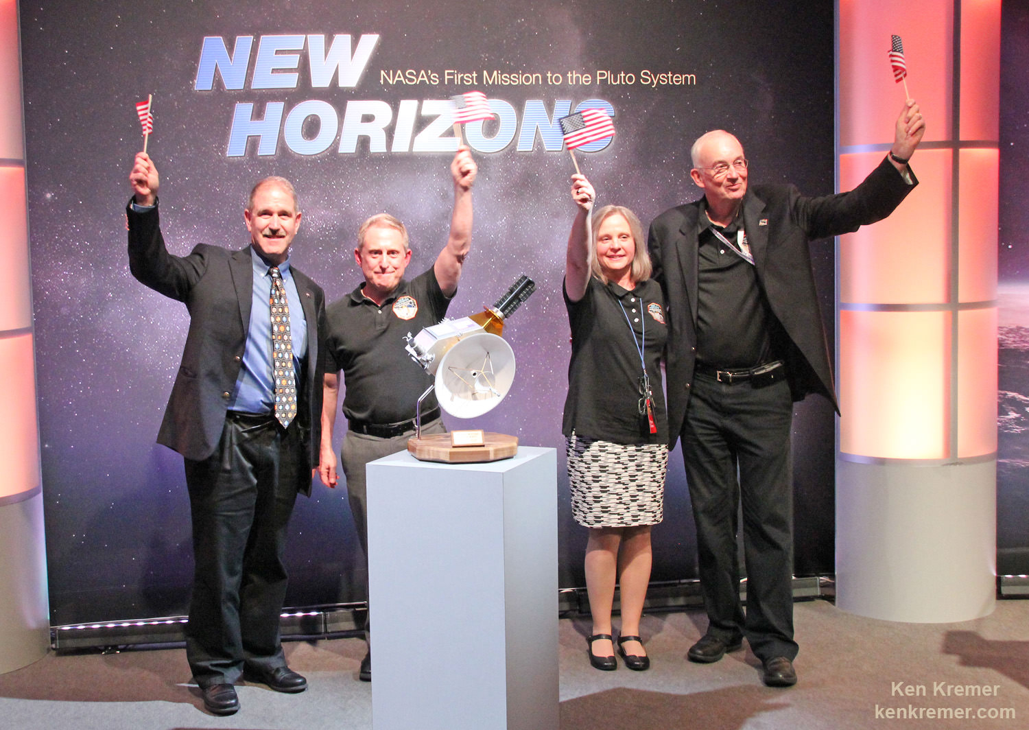
Pluto Explored at Last
The New Horizons mission team celebrates successful flyby of Pluto in the moments after closest approach at 7:49 a.m. EDT on July 14, 2015. New Horizons Principal Investigator Alan Stern of Southwest Research Institute (SwRI), Boulder, CO., left, Johns Hopkins University Applied Physics Laboratory (APL) Director Ralph Semmel, center, and New Horizons Co-Investigator Will Grundy Lowell Observatory hold an enlarged print of an U.S. stamp with their suggested update after Pluto became the final planet in our solar system to be explored by an American space probe (crossing out the words ‘not yet’) – at the Johns Hopkins University Applied Physics Laboratory (APL) in Laurel, Maryland. Credit: Ken Kremer/kenkremer.comHighest resolution mosaic of ‘Tombaugh Regio’ shows the heart-shaped region on Pluto focusing on ice flows and plains of ‘Sputnik Planum’ at top and icy mountain ranges of ‘Hillary Montes’ and ‘Norgay Montes’ below. This new mosaic combines the seven highest resolution images captured by NASA’s New Horizons LORRI imager during history making closest approach flyby on July 14, 2015. Inset at right shows global view of Pluto with location of mosaic and huge heart-shaped region in context. Annotated with place names. Credit: NASA/JHUAPL/SWRI/ Marco Di Lorenzo/Ken Kremer/kenkremer.comThis new global mosaic view of Pluto was created from the latest high-resolution images to be downlinked from NASA’s New Horizons spacecraft and released on Sept. 11, 2015. The images were taken as New Horizons flew past Pluto on July 14, 2015, from a distance of 50,000 miles (80,000 kilometers). This new mosaic was stitched from over two dozen raw images captured by the LORRI imager and colorized. Right side inset from New Horizons team focuses on Tombaugh Regio heart shaped feature. Annotated with informal place names. Credits: NASA/Johns Hopkins University Applied Physics Laboratory/Southwest Research Institute/Marco Di Lorenzo/Ken Kremer/kenkremer.com
Large-scale crossbedding in the sandstone of this ridge on a lower slope of Mars' Mount Sharp is typical of windblown sand dunes that have petrified. NASA's Curiosity Mars rover used its Mastcam to capture this vista on Aug. 27, 2015, Sol 1087. Similarly textured sandstone is common in the U.S. Southwest. Credits: NASA/JPL-Caltech/MSSS
Large-scale crossbedding in the sandstone of this ridge on a lower slope of Mars’ Mount Sharp is typical of windblown sand dunes that have petrified. NASA’s Curiosity Mars rover used its Mastcam to capture this vista on Aug. 27, 2015, Sol 1087. Similarly textured sandstone is common in the U.S. Southwest. Credits: NASA/JPL-Caltech/MSSS
See Sol 1100 mosaic below [/caption]
NASA’s SUV-sized Curiosity rover has arrived at a beautiful Martian vista displaying a huge deposit of magnificently petrified sand dunes that look remarkably like some commonly found on Earth and native to the deserts of the U.S. Southwest.
The petrified sand dunes were discovered amongst an area of dark sandstone along a ridge at the lower slope of Mars’ Mount Sharp. They are now being explored in detail by the six wheeled rover in a geologic feature dubbed the Stimson unit.
“The team is considering where to drill next within the Stimson sandstone and we are looking for the best light toned areas to check for mineralogical signs of water-rock reaction,” says John Bridges, rover team member from the University of Leicester, England, in the latest mission update from today, September 12, 2015.
Curiosity looks toward fabulous canyons and buttes at the base of Mount Sharp from the Stimson sand dunes on Mars on Sol 1100, Sept. 10 2015 in this photo mosaic stitched from Mastcam color camera raw images. Credit: NASA/JPL/MSSS/Ken Kremer/kenkremer.com/Marco Di Lorenzo
Curiosity also discovered large-scale crossbedding in the sandstone that were formed by the action of Martian winds.
“This sandstone outcrop — part of a geological layer that Curiosity’s science team calls the Stimson unit — has a structure called crossbedding on a large scale that the team has interpreted as deposits of sand dunes formed by wind,” according to the rover team.
So Curiosity was commanded by her handlers back on Earth to capture an array of high resolution imagery as part of detailed investigation of the area for up close and contact science.
Dozens of images were taken with the pair of high resolution Mastcam color cameras on the robots mast and combined into the panoramic scene show above and another shown below with a scalebar the length of a tall human, 6.6 feet or 200 centimeters.
Large-scale crossbedding in the sandstone of this ridge on a lower slope of Mars’ Mount Sharp is typical of windblown sand dunes that have petrified. NASA’s Curiosity Mars rover used its Mastcam to capture this vista on Aug. 27, 2015. Similarly textured sandstone is common in the U.S. Southwest. Credits: NASA/JPL-Caltech/MSSS
The images were taken on Aug. 27, 2015, corresponding to Sol 1087 of the rover’s work on Mars, using both the 34 millimeter-focal-length lens and the 100 mm millimeter-focal-length telephoto Mastcam camera lenses that function as Curiosity’s left and right eyes.
The panorama spans the Martian terrain looking from the east, at left, to the south-southwest at right.
“Some of the dark sandstone in the area …. shows texture and inclined bedding structures characteristic of deposits that formed as sand dunes, then were cemented into rock” say officials.
“Sets of bedding laminations lie at angles to each other.”
Since taking the panorama in late August, the team has driven Curiosity around the area to collect more measurements with her state of the art science instruments.
Later this month, Curiosity will drill into an outcrop at the Stimson unit sandstone for collection and feed it for analysis into the pair of on board chemistry labs – SAM and CheMin- located inside the rover’s belly.
Curiosity already carried out initial contact science in the area by extending the robotic arm to rock targets for investigation with the arm mounted instruments, including the MAHLI camera and APXS spectrometer.
Curiosity “investigated an outcrop of the Stimson unit … and conducted successful contact science,” says Lauren Edgar, Research Geologist at the USGS Astrogeology Science Center and an MSL science team member, in a mission update.
Scientists will select the Stimson drill target soon.
Curiosity rover explores around the Stimson unit at the base of Mount Sharp on Mars on Sol 1095, Sept. 5, 2015 in this photo mosaic stitched from Mastcam color camera raw images. Credit: NASA/JPL/MSSS/Marco Di Lorenzo/Ken Kremer/kenkremer.com
Why explore outcrops at Stimson?
“The Stimson unit overlies a layer of mudstone that was deposited in a lake environment. Curiosity has been examining successively higher and younger layers of Mount Sharp, starting with the mudstone at the mountain’s base, for evidence about changes in the area’s ancient environment.”
Curiosity’s prior drill campaign was recently conducted at the “Buckskin” outcrop target in early August 2015. Buckskin was very notable for being the first high silica rock drilling target of the mission.
Curiosity extends robotic arm and conducts sample drilling at “Buckskin” rock target at bright toned “Lion” outcrop at the base of Mount Sharp on Mars, seen at right. Gale Crater eroded rim seen in the distant background at left, in this composite multisol mosaic of navcam raw images taken to Sol 1059, July 30, 2015. Navcam camera raw images stitched and colorized. Inset: MAHLI color camera up close image of full depth drill hole at “Buckskin” rock target on Sol 1060. Credit: NASA/JPL-Caltech/MSSS/Ken Kremer/kenkremer.com/Marco Di Lorenzo
Stimson and Buckskin sit at the base of Mount Sharp, a huge layered mountain that dominates the center of the 96 mile-wide (154 kilometers-wide) Gale Crater landing site.
Exploring the sedimentary layers of Mount Sharp, which towers 3.4 miles (5.5 kilometers) into the Martian sky, is the primary destination and goal of the rovers long term scientific expedition on the Red Planet.
As of today, Sol 1102, September 12, 2015, she has driven some 6.9 miles (11.1 kilometers) kilometers and taken over 268,000 amazing images.
Curiosity has already accomplished her primary objective of discovering a habitable zone on the Red Planet – at the Yellowknife Bay area – that contains the minerals necessary to support microbial life in the ancient past when Mars was far wetter and warmer billions of years ago.
Curiosity rover scans toward south east around Marias Pass area at the base of Mount Sharp on Mars on Sol 1074, Aug. 14, 2015 in this photo mosaic stitched from Mastcam color camera raw images. Credit: NASA/JPL/MSSS/Marco Di Lorenzo/Ken Kremer/kenkremer.com
Stay tuned here for Ken’s continuing Earth and planetary science and human spaceflight news.