Wow! Asteroid/Dwarf Planet Ceres Once had an Ocean?

A view of Ceres in natural colour, pictured by the Dawn spacecraft in May 2015. Credit: NASA/ JPL/Planetary Society/Justin Cowart

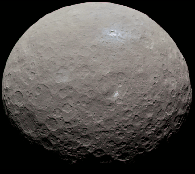
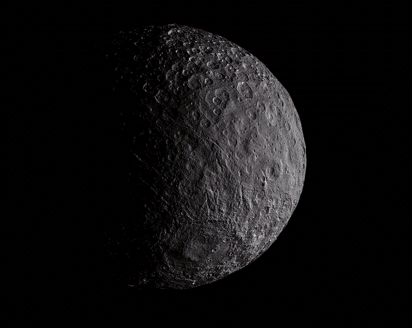
In March of 2015, NASA’s Dawn mission arrived around Ceres, a protoplanet that is the largest object in the Asteroid Belt. Along with Vesta, the Dawn mission seeks to characterize the conditions and processes of the early Solar System by studying some of its oldest objects. One thing Dawn has determined since its arrival is that water-bearing minerals are widespread on Ceres, an indication that the protoplanet once had a global ocean.

Naturally, this has raised many questions, such as what happened to this ocean, and could Ceres still have water today? Towards this end, the Dawn mission team recently conducted two studies that shed some light on these questions. Whereas the former used gravity measurements to characterize the interior of the protoplanet, the latter sought to determine its interior structure by studying its topography.

The first study, titled “Constraints on Ceres’ internal structure and evolution from its shape and gravity measured by the Dawn spacecraft“, was recently published in the Journal of Geophysical Research. Led by Anton Ermakov, a postdoctoral researcher at JPL, the team also consisted of researchers from the NASA’s Goddard Space Flight Center, the German Aerospace Center, Columbia University, UCLA and MIT.

Ceres. as imaged by the NASA Dawn probe. Credit: NASA/JPL-Caltech/UCLA/MPS/DLR/IDA

Together, the team relied on gravity measurements of the protoplanet, which the Dawn probe has been collecting since it established orbit around Ceres. Using the Deep Space Network to track small changes in the spacecraft’s orbit, Ermakov and his colleagues were able to conduct shape and gravity data measurements of Ceres to determine the internal structure and composition.

What they found was that Ceres shows signs of being geologically active; if not today, than certainly in the recent past. This is indicated by the presence of three craters – Occator, Kerwan and Yalode – and Ceres’ single tall mountain, Ahuna Mons. All of these are associated with “gravity anomalies”, which refers to discrepancies between the way scientists have modeled Ceres’ gravity and what Dawn observed in these four locations.

The team concluded that these four features and other outstanding geological formations, are therefore indications of cryovolcanism or subsurface structures. What’s more, they determined that the crust’s density was relatively low, being closer to that of ice than solid rock.  This, however, was inconsistent with a previous study performed by Dawn guest investigator Michael Bland of the U.S. Geological Survey.

Bland’s study, which was published in Nature Geoscience back in 2016, indicated that ice is not likely to be the dominant component of Ceres strong crust, on a count of it being too soft. Naturally, this raises the question of how the crust could be light as ice in terms of density, but also much stronger. To answer this, the second team attempted to model how Ceres’ surface evolved over time.

Gravity measurements of Ceres, which provided  hints about its internal structure. Credit: NASA/JPL-Caltech/UCLA/MPS/DLR/IDA

Their study, titled “The Interior Structure of Ceres as Revealed by Surface Topography and Gravity“, was published in the journal Earth and Planetary Science Letters. Led by Roger Fu, an assistant professor with the Department of Earth, Atmospheric and Planetary Sciences at MIT, this team consisted of members from Virginia Tech, Caltech, the Southwest Research Institute (SwRI), the US Geological Survey, and the INAF.

Together, they investigated the strength and composition of Ceres’ crust and deeper interior by studying the dwarf planet’s topography. By modeling how the protoplanet’s crust flows, Fu and colleagues determined that it is likely a mixture of ice, salts, rock, and likely clathrate hydrate. This type of structure, which is composed of a gas molecule surrounded by water molecules, is 100 to 1,000 times stronger than water ice.

This high-strength crust, they theorize, could rest on a softer layer that contains some liquid. This would have allowed Ceres’ topography to deform over time, smoothing down features that were once more pronounced. It would also account for its possible ancient ocean, which would have frozen and become bound up with the crust. Nevertheless, some of its water would still exist in a liquid state underneath the surface.

This theory is consistent with several thermal evolution models which were published before the Dawn mission arrived at Ceres. These models contend that Ceres’ interior contains liquid water, similar to what has been found on Jupiter’s moon Europa and Saturn’s moon Enceladus. But in Ceres’ case, this liquid could be what is left over from its ancient ocean rather than the result of present-day geological activity in the interior.

Diagram showing a possible internal structure of Ceres. Credit: NASA/ESA/STScI/A. Feild

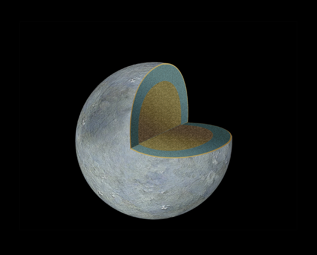
Taken together, these studies indicate that Ceres has had a long and turbulent history. While the first study found that Ceres’ crust is a mixture of ice, salts and hydrated materials – which represents most of its ancient ocean – the second study suggests there is a softer layer beneath Ceres’ rigid surface crust, which could be the signature of residual liquid left over from the ocean.

As Julie Castillo-Rogez, the Dawn project scientist at JPL and a co-author on both studies, explained, “More and more, we are learning that Ceres is a complex, dynamic world that may have hosted a lot of liquid water in the past, and may still have some underground.”

On October 19, 2017, NASA announced that the Dawn mission would be extended until its fuel runs out, which is expected to happen in the latter half of 2018. This extension means that the Dawn probe will be in orbit around Ceres as it goes through perihelion in April 2018. At this time, surface ice will start to evaporate to form a transient atmosphere around the body.

During this period and long after, the spacecraft is likely to remain in a stable orbit around Ceres, where it will continue to send back information on this protoplanet/large asteroid. What it teaches us will also go a long way towards informing our understanding of the early Solar System and how it evolved over the past few billion years.

In the future, it is possible that a mission will be sent to Ceres that is capable of landing on its surface and exploring its topography directly. With any luck, future missions will also be able to explore the interior of Ceres, and other “ocean worlds” like Europa and Enceladus, and find out what lurks beneath their icy surfaces!

Further Reading: NASA

The X3 Ion Engine Test Break Thrust Records

A prototype Hall-effect thruster being tested at NASA's Glenn Research Center. Credit: NASA

When it comes to the future of space exploration, a number of new technologies are being investigated. Foremost among these are new forms of propulsion that will be able to balance fuel-efficiency with power. Not only would engines that are capable of achieving a great deal of thrust using less fuel be cost-effective, they will be able to ferry astronauts to destinations like Mars and beyond in less time.

This is where engines like the X3 Hall-effect thruster comes into play. This thruster, which is being developed by NASA’s Glenn Research Center in conjunction with the US Air Force and the University of Michigan, is a scaled-up model of the kinds of thrusters used by the Dawn spacecraft. During a recent test, this thruster shattered the previous record for a Hall-effect thruster, achieving higher power and superior thrust.

Hall-effect thrusters have garnered favor with mission planners in recent years because of their extreme efficiency. They function by turning small amounts of propellant (usually inert gases like xenon) into charged plasma with electrical fields, which is then accelerated very quickly using a magnetic field. Compared to chemical rockets, they can achieve top speeds using a tiny fraction of their fuel.

Artist’s concept of Dawn mission using its blue ion engine to reach Ceres in the distance. Credit: NASA/JPL

However, a major challenge so far has been building a Hall-effect thruster that is capable of achieving high levels of thrust as well. While fuel efficient, conventional ion engines typically produce only a fraction of the thrust produced by rockets that rely on solid-chemical propellants. Hence why NASA has been developing the scaled-up model X3 thruster in conjunction with its partners.

The development of the thruster has been overseen by Alec Gallimore, a professor of aerospace engineering and the Robert J. Vlasic Dean of Engineering at the University of Michigan. As he indicated in a recent Michigan News press statement:

“Mars missions are just on the horizon, and we already know that Hall thrusters work well in space. They can be optimized either for carrying equipment with minimal energy and propellant over the course of a year or so, or for speed—carrying the crew to Mars much more quickly.”

In recent tests, the X3 shattered the previous thrust record set by a Hall thruster, achieving 5.4 newtons of force compared with the old record of 3.3 newtons. The X3 also more than doubled the operating current (250 amperes vs. 112 amperes) and ran at a slightly higher power than the previous record-holder (102 kilowatts vs. 98 kilowatts). This was encouraging news, since it means that the engine can offer faster acceleration, which means shorter travel times.

Scott Hall makes some final adjustments on the thruster before the test begins. Credit: NASA

The test was carried about by Scott Hall and Hani Kamhawi at the NASA Glenn Research Center in Cleveland. Whereas Hall is a doctoral student in aerospace engineering at U-M, Kamhawi is NASA Glenn research scientist who has been heavily involved in the development of the X3. In addition, Kamhawi is also Hall’s NASA mentor, as part of the NASA Space Technology Research Fellowship (NSTRF).

This test was the culmination of more than five years of research which sought to improve upon current Hall-effect designs. To conduct the test, the team relied on NASA Glenn’s vacuum chamber, which is currently the only chamber in the US that can handle the X3 thruster. This is due to the sheer amount of exhaust the thruster produces, which can result in ionized xenon drifting back into the plasma plume, thus skewing the test results.

NASA Glenn’s setup is the only one with a vacuum pump powerful enough to create the conditions necessary to keep the exhaust clean. Hall and Kamhawi also had to build a custom thrust stand to support the X3’s 227 kg (500 pound) frame and withstand the force it generates, since existing stands were not up to the task. After securing a test window, the team spent four weeks prepping the stand, the thruster, and setting up all the necessary connections.

All the while, NASA researchers, engineers and technicians were on hand to provide support. After 20 hours of pumping to achieve a space-like vacuum inside the chamber, Hall and Kamhawi conducted a series of tests where the engine would be fired for 12-hours straight. Over the course of 25 days, the team brought the X3 up to its record-breaking power, current and thrust levels.

A side shot of the X3 firing at 50 kilowatts. Credit: NASA

Looking ahead, the team plans to conduct more tests in Gallimore’s lab at U-M using an upgraded vacuum chamber. These upgrades will are schedules to be completed by January of 2018, and will enable the team to conduct future tests in-house. This upgrade was made possible thanks to a $1 million USD grant, contributed in part by the Air Force Office of Scientific Research, with additional support provided by the Jet Propulsion Laboratory and U-M.

The X3’s power supplies are also being developed by Aerojet Rocketdyne, the Sacramento-based rocket and missile propulsion manufacturer that is also the lead on the propulsion system grant from NASA. By Spring of 2018, the engine is expected to be integrated with these power systems; at which point, a series of 100-hour tests that will once again be conducted at the Glenn Research Center.

The X3 is one of three prototypes that NASA is investigating for future crewed missions to Mars, all of which are intended to reduce travel times and reduce the amount of fuel needed. Beyond making such missions more cost-effective, the reduced transit times are also intended to reduce the amount of radiation astronauts will be exposed to as they travel between Earth and Mars.

The project is funded through NASA’s Next Space Technologies for Exploration Partnership (Next-STEP), which supports not just propulsion systems but also habitat systems and in-space manufacturing.

Further Reading: Michigan News

Weekly Space Hangout – Oct 25, 2017: Dr. John Charles of NASA’s Human Research Program

Hosts:
Fraser Cain (universetoday.com / @fcain)
Dr. Paul M. Sutter (pmsutter.com / @PaulMattSutter)
Dr. Kimberly Cartier (KimberlyCartier.org / @AstroKimCartier )
Dr. Morgan Rehnberg (MorganRehnberg.com / @MorganRehnberg ChartYourWorld.org)

Special Guest:
John B. Charles, Ph.D., is the Chief Scientist of NASA’s Human Research Program (HRP), responsible for the scientific direction of human research and technology development enabling astronauts to go beyond low Earth orbit and eventually to Mars.

Announcements:

If you would like to join the Weekly Space Hangout Crew, visit their site here and sign up. They’re a great team who can help you join our online discussions!

We record the Weekly Space Hangout every Wednesday at 5:00 pm Pacific / 8:00 pm Eastern. You can watch us live on Universe Today, or the Weekly Space Hangout YouTube page – Please subscribe!

You Can Now Use Google Maps to Explore the Solar System

Google Maps now lets users explore the Solar System. Credit: NASA/Google

Chances are, at one time or another, we’ve all used Google Maps to find the shortest route from point A to point B. But if you are like some people, you’ve used this mapping tool to have a look at geographical features or places you hope to visit someday. In an age where digital technology is allowing for telecommuting and even telepresence, it’s nice to take virtual tours of the places we may never get to see in person.

But now, Google Maps is using its technology to enable the virtual exploration of something far grander: the Solar System! Thanks to images provided by the Cassini orbiter of the planets and moons it studied during its 20 year mission, Google is now allowing users to explore places like Venus, Mercury, Mars, Europa, Ganymede, Titan, and other far-off destinations that are impossible for us to visit right now.

Similar to how Google Earth uses satellite imagery to create 3D representations of our planet, this new Google Maps tool relies on the more than 500,000 images taken by Cassini as it made its way across the Solar System. This probe recently concluded its 20 year mission, 13 of which were spent orbiting Saturn and studying its system of moons, by crashing into the atmosphere of Saturn.

Artist rendition of the Cassini spacecraft over Saturn. Credit: NASA/JPL-Caltech/SSI/Kevin M. Gill.

After launching from Earth on October 15th, 1997, Cassini conducted a flyby of Venus in order to pick up a gravity-assist. It then flew by Earth, obtaining a second gravity-assist, while making its way towards the Asteroid Belt. Before reaching the Saturn System, where it would begin studying the gas giant and its moons, Cassini also conducted a flyby of Jupiter – snapping pictures of its moons, rings, and Great Red Spot.

When it reached Saturn in July of 2004, Cassini went to work studying the planet and its larger moons – particularly Titan and Enceladus. During the next 13 years and 76 days, the probe would provide breathtaking images and sensor data on Saturn’s rings, atmosphere and polar storms and reveal things about Titan’s surface that were never before seen (such as its methane lakes, hydrological cycle, and surface features).

It’s flybys of Enceladus also revealed some startling things about this icy moon. Aside from detecting a tenuous atmosphere of ionized water vapor and Enceladus’ mysterious “Tiger Stripes“, the probe also detected jets of water and organic molecules erupting from the moon’s southern polar region. These jets, it was later determined, were indicative of a warm water ocean deep in the moon’s interior, and possibly even life!

Interestingly enough, the original Cassini mission was only planned to last for four years once it reached Saturn – from June 2004 to May 2008. But by the end of this run, the mission was extended with the Cassini Equinox Mission, which was intended to run until September of 2010. It was extended a second time with the Cassini Solstice Mission, which lasted until September 15th, 2017, when the probe was crashed into Saturn’s atmosphere.

Artist’s impression of the Cassini orbiter entering Saturn’s atmosphere. Credit: NASA/JPL

Thanks to all the images taken by this long-lived mission, Google Maps is now able to offer exploratory tours of 16 celestial bodies in the Solar System – 12 of which are new to the site. These include Earth, the Moon, Mercury, Venus, Mars, Pluto, Ceres, Io, Europa, Ganymede, Mimas, Enceladus, Dione, Rhea, Titan, Iapetus and (available as of July 2017) the International Space Station.

This latest development also builds on several extensions Google has released over the years. These include Google Moon, which was released on July 20th, 2005, to coincide with the 36th anniversary of the Apollo 11 Moon Landing. Then there was Google Sky (introduced in 2007), which used photographs taken by the Hubble Space Telescope to create a virtual map of the visible universe.

Then there was Google Mars, the result of a collaborative effort between Google and NASA scientists at the Mars Space Flight Facility released in 2011, one year before the Curiosity rover landed on the Red Planet. This tool relied on data collected by the Mars Global Surveyor and the Mars Odyssey missions to create high-resolution 3D terrain maps that included elevations.

In an age of high-speed internet and telecommunications, using the internet to virtually explore the many planets and bodies of the Solar System just makes sense. Especially when you consider that even the most ambitious plans to conduct tourism to Mars or the Moon (looking at you, Elon Musk and Richard Branson!) are not likely to bear fruit for many years, and cost an arm and a leg to boot!

In the future, similar technology could lead to all kinds of virtual exploration. This concept, which is often referred to as “telexploration”, would involve robotic missions traveling to other planets and even star systems. The information they gather would then be sent back to Earth to create virtual experiences, which would allow scientists and space-exploration enthusiasts to feel like they were seeing it firsthand.

In truth, this mapping tool is just the latest gift to be bestowed by the late Cassini mission. NASA scientists expect to be sifting through the volumes of data collected by the orbiter for years to come. Thanks to improvements made in software applications and the realms of virtual and augmented reality, this data (and that of present and future missions) is likely to be put to good use, enabling breathtaking and educational tours of our Universe!

Further Reading: Make Use Of

Covert NRO Satellite Fades into Capes Cloudy Night Skies Shrouded in Liftoff Secrecy: Gallery – As ULA Atlas Wins Landsat Launch

Covert NROL-52 spy satellite for the National Reconnaissance Office fades into cloudy nighttime skies shrouded in secrecy after liftoff on a United Launch Alliance (ULA) Atlas V rocket at 3:28 a.m. EDT on Oct. 15, 2017 from Space Launch Complex-41 at Cape Canaveral Air Force Station in Florida. Credit: Ken Kremer/kenkremer.com

CAPE CANAVERAL AIR FORCE STATION, FL — As one Atlas rocket carrying a covert spy satellite for the U.S. National Reconnaissance Office (NRO) to monitor Earth for national security purposes faded into cloudy nighttime skies over the Cape in the dead of night shrouded in liftoff secrecy, rocket builder United Launch Alliance (ULA) won another significant Atlas launch contract for NASA’s Landsat 9 satellite to monitor the health of Earth’s environment.

Capping two launches from two different rocket companies in four days by ULA and SpaceX followed by the arrival back in port of SpaceX’s ocean landed recovered booster, last week provided all the proof that’s needed to demonstrate that the revitalization of Florida’s Spaceport is well underway and America’s rocket makers are capturing lucrative launch contracts ensuring an upswing nationwide in rocket and spacecraft manufacturing – for critical military surveillance, government, civilian and science needs.

Check out the exciting gallery of Atlas launch imagery and videos including the thrilling droneship return of SpaceX’s 156 foot tall first stage booster back into Port Canaveral less than 4 hours after ULA delivered the classified NROL-52 surveillance satellite to a secret orbit – from this author and several space media colleagues. And check back here as the gallery grows!

A ULA Atlas V launch carrying the covert NROL-52 mission in support of U.S. national security blasted off overnight Sunday, Oct. 15 at 3:28 a.m. EDT (0728 GMT) from seaside Space Launch Complex-41 at Cape Canaveral Air Force Station in Florida.

“Congratulations to the team who helped make #NROL52 a success! United Launch Alliance, 45th Space Wing at Patrick Air Force Base, Fla., Air Force Space Command, and the Space and Missile Systems Center,” the NRO announced post launch on social media.

It was a case of ‘Going, Going, Gone’ as seemingly endless stormy weather plagued the space coast and the Atlas soon disappeared behind clouds from many but not all vantage points, as the two stage rocket was finally cleared to launch on its fifth try. Postponed three times by poor weather and once due to a technical glitch to fix a faulty second stage transmitter.

Reflecting in a pond a United Launch Alliance (ULA) Atlas V rocket blasts off with the covert NROL-52 spy satellite for the National Reconnaissance Office at 3:28 a.m. EDT on Oct. 15, 2017 from Space Launch Complex-41 at Cape Canaveral Air Force Station in Florida. Credit: Ken Kremer/kenkremer.com

The launches were postponed by the downstream impact of Hurricane Irma which forced the base closings of the Kennedy Space Center and Cape Canaveral Air Force Station and significantly impacted the Florida Space Coast region by causing over $100 million in damage to buildings, homes, businesses, hotels, restaurants, infrastructure and more due to flooding and hurricane force winds.

“We’ve had an incredible month,” said Brig. Gen. Wayne R. Monteith, Commander, 45th Space Wing.

“Not only did we restore our base to full mission capable status just a few hours after Hurricane Irma impacted our coast, but we’ve successfully launched two rockets in less than four days just weeks later.”

Covert NROL-52 spy satellite for the National Reconnaissance Office fades into cloudy nighttime skies shrouded in secrecy after liftoff on a United Launch Alliance (ULA) Atlas V rocket at 3:28 a.m. EDT on Oct. 15, 2017 from Space Launch Complex-41 at Cape Canaveral Air Force Station in Florida. Credit: Ken Kremer/kenkremer.com

“The 45th Space Wing supported ULA’s Atlas V launch of the NROL-52 mission for the National Reconnaissance Office early morning on Oct. 15!”

“The men and women of the 45th Space Wing continue to make the impossible possible.”

Reflecting in a pond a United Launch Alliance (ULA) Atlas V rocket blasts off with the covert NROL-52 spy satellite for the National Reconnaissance Office at 3:28 a.m. EDT on Oct. 15, 2017 from Space Launch Complex-41 at Cape Canaveral Air Force Station in Florida. Credit: Ken Kremer/kenkremer.com

More than a quarter of all the world’s rocket launches take place from Florida’s burgeoning spaceports.

Covert NROL-52 spy satellite for the National Reconnaissance Office fades into cloudy nighttime skies shrouded in secrecy after liftoff on a United Launch Alliance (ULA) Atlas V rocket at 3:28 a.m. EDT on Oct. 15, 2017 from Space Launch Complex-41 at Cape Canaveral Air Force Station in Florida. Credit: Ken Kremer/kenkremer.com

“Our team’s resiliency and tireless efforts in launching over 25% of all world-wide launches this year proves why we are the ‘World’s Premier Gateway to Space,’” Montieth gushed in pride.

Meanwhile, NASA selected ULA to provide launch services for the Landsat 9 mission with another Atlas V rocket as soon as late 2020.

“The mission is currently targeted for a contract launch date of June 2021, while protecting for the ability to launch as early as December 2020, on an Atlas V 401 rocket from Space Launch Complex 3E at Vandenberg Air Force Base in California,” said NASA.

The Landsat 9 launch contract is worth $153.8 million.

Landsat 9 is a joint mission between NASA and the U.S. Geological Survey (USGS).

“Landsat 9 will continue the Landsat program’s critical role in monitoring, understanding, and managing the land resources needed to sustain human life.”

“We are honored that NASA has entrusted ULA with launching this critical land imaging satellite,” said Tory Bruno, ULA’s president and chief executive, in a statement.

“ULA’s world-leading performance and reliability, paired with the tremendous heritage of 74 consecutive successful Atlas V launches, provides the optimal value for our customer. We look forward to working together again with our mission partners at NASA’s Launch Services Program, Goddard Space Flight Center and the U.S. Geological Survey in the integration and launch of this significant mission, contributing to the international strategy for examining the health and state of the Earth.”

ULA Atlas V rocket streaks to orbit in this long duration exposure carrying covert NROL-52 payload for the NRO after lift off from Space Launch Complex-41 on Oct. 15, 2017 at 3:28 a.m. EDT at Cape Canaveral Air Force Station in Florida. Credit: Jeff Seibert

NROL-52 is the fourth of five launches slated for the NRO in 2017 by both ULA and SpaceX.

“Never before has innovation been more important for keeping us ahead of the game. As the eagle soars, so will the advanced capabilities this payload provides to our national security,” said Colonel Matthew Skeen, USAF, Director, NRO Office of Space Launch, in a statement. “Kudos to the entire team for a job well done.”

Check out this exciting video compilation from remote cameras circling the Atlas pad 41.

Video Caption: Launch of the NROL-52 satellite on an Atlas 5 booster from Pad 41. A United Launch Alliance Atlas 5 421 rocket launches the NROL-52 payload on Oct. 15, 2017 at 328 a.m. EDT on the 5th launch attempt. Previous launch attempts were halted by weather issues 3 times, and a faulty telemetry radio that needed to be replaced after the rocket was rolled back to the Pad 41 Vertical Integration Facility. Credit Jeff Seibert

The venerable two stage Atlas V stands 194 feet tall and sports a 100% success record. The first stage generates approx. 1.6 million pounds of liftoff thrust.

This Atlas Evolved Expendable Launch Vehicle (EELV) mission launched in the 421 configuration vehicle, which includes a 4-meter payload fairing (PLF) encapsulating the payload and two strap on solid rocket first stage boosters.

The Atlas first stage booster for this mission was powered by the Russian-built RD AMROSS RD-180 engine, and the Centaur upper stage was powered by the Aerojet Rocketdyne RL10C-1 engine.

The dual chamber, dual-nozzle RD-180 is fueled by a mixture of RP-1 kerosene and LOX (liquid oxygen).

The ULA Atlas V first stage powers NROL-52 spy satellite to orbit for the NRO firing the dual chamber, dual-nozzle RD-180 engines after blastoff at 3:28 a.m. EDT on Oct. 15, 2017 from Space Launch Complex-41 at Cape Canaveral Air Force Station in Florida. Credit: Ken Kremer/kenkremer.com

The next NRO launch is scheduled on a ULA Delta IV in December from Vandenberg Air Force Base, California.

Reflecting in a pond a United Launch Alliance (ULA) Atlas V rocket blasts off with the covert NROL-52 spy satellite for the National Reconnaissance Office at 3:28 a.m. EDT on Oct. 15, 2017 from Space Launch Complex-41 at Cape Canaveral Air Force Station in Florida. Credit: Ken Kremer/kenkremer.com

Watch for Ken’s continuing onsite NROL-52, SpaceX SES-11 and NASA and space mission reports direct from the Kennedy Space Center and Cape Canaveral Air Force Station, Florida.

Stay tuned here for Ken’s continuing Earth and Planetary science and human spaceflight news.

Ken Kremer

Liftoff of ULA Atlas V rocket carrying classified NROL-52 payload for the NRO on Oct. 15, 2017 from Cape Canaveral Air Force Station in Florida. Credit: Julian Leek
United Launch Alliance (ULA) Atlas V rocket streaks to orbit in this long duration exposure carrying covert NROL-52 payload for the National Reconnaissance Office after lift off from Space Launch Complex-41 on Oct. 15, 2017 at 3:28 a.m. EDT at Cape Canaveral Air Force Station in Florida. Credit: Ken Kremer/kenkremer.com
Reflecting in a pond a ULA Atlas V rocket stands poised for launch with the NROL-52 surveillance satellite for the National Reconnaissance Office prior to blastoff on Oct. 15, 2017 from Space Launch Complex-41 at Cape Canaveral Air Force Station in Florida. Credit: Ken Kremer/kenkremer.com
Reflown SpaceX Falcon 9 first stage booster arrives at sunrise atop OCISLY droneship being towed into the mouth of Port Canaveral, FL on Oct. 15, 2017 after successfully launch SES-11 UHDTV comsat to orbit on Oct. 11, 2017. Credit: Ken Kremer/Kenkremer.com
ULA Atlas V rocket blasts off carrying covert NROL-52 payload for the NRO from Space Launch Complex-41 on Oct. 15, 2017 at 3:28 a.m. EDT at Cape Canaveral Air Force Station in Florida. Credit: Jeff Seibert

Looking for Signs of Life on Distant Planets Just Got Easier

This illustration shows a star's light illuminating the atmosphere of a planet. Credits: NASA Goddard Space Flight Center

When it comes to searching for worlds that could support extra-terrestrial life, scientists currently rely on the “low-hanging fruit” approach. Since we only know of one set of conditions under which life can thrive – i.e. what we have here on Earth – it makes sense to look for worlds that have these same conditions. These include being located within a star’s habitable zone, having a stable atmosphere, and being able to maintain liquid water on the surface.

Until now, scientists have relied on methods that make it very difficult to detect water vapor in the atmosphere’s of terrestrial planets. But thanks to a new study led by Yuka Fujii of NASA’s Goddard Institute for Space Studies (GISS), that may be about to change. Using a new three-dimensional model that takes into account global circulation patterns, this study also indicates that habitable exoplanets may be more common than we thought.

The study, titled “NIR-driven Moist Upper Atmospheres of Synchronously Rotating Temperate Terrestrial Exoplanets“, recently appeared in The Astrophysical Journal. In addition to Dr. Fujii, who is also a member of the Earth-Life Science Institute at the Tokyo Institute of Technology, the research team included Anthony D. Del Genio (GISS) and David S. Amundsen (GISS and Columbia University).

Artist’s concept of the hot Jupiter WASP-121b, which presents the best evidence yet of a stratosphere on an exoplanet – generated using Engine House VFX. Credit: Bristol Science Centre/University of Exeter

To put it simply, liquid water is essential to life as we know it. If a planet does not have a warm enough atmosphere to maintain liquid water on its surface for a sufficient amount of time (on the order of billions of years), then it is unlikely that life will be able to emerge and evolve. If a planet is too distant from its star, its surface water will freeze; if it is too close, its surface water will evaporate and be lost to space.

While water has been detected in the atmospheres of exoplanets before, in all cases, the planets were massive gas giants that orbited very closely to their stars. (aka. “Hot Jupiters”). As Fujii and her colleagues state in their study:

“Although H2O signatures have been detected in the atmospheres of hot Jupiters, detecting molecular signatures, including H2O, on temperate terrestrial planets is exceedingly challenging, because of the small planetary radius and the small scale height (due to the lower temperature and presumably larger mean molecular weight).”

When it comes to terrestrial (i.e. rocky) exoplanets, previous studies were forced to rely on one-dimensional models to calculate the presence of water. This consisted of measuring hydrogen loss, where water vapor in the stratosphere is broken down into hydrogen and oxygen from exposure to ultraviolet radiation. By measuring the rate at which hydrogen is lost to space, scientists would estimate the amount of liquid water still present on the surface.

Artist’s impression of the “Venus-like” exoplanet GJ 1132b. Credit: cfa.harvard.edu

However, as Dr. Fujii and her colleagues explain, such models rely on several assumptions that cannot be addressed, which include the global transport of heat and water vapor vapor, as well as the effects of clouds. Basically, previous models predicted that for water vapor to reach the stratosphere, long-term surface temperatures on these exoplanets would have to be more than 66 °C (150 °F) higher than what we experience here on Earth.

These temperatures could create powerful convective storms on the surface. However, these storms could not be the reason water reaches the stratosphere when it comes to slowly rotating planets entering a moist greenhouse state – where water vapor intensifies heat. Planets that orbit closely to their parent stars are known to either have a slow rotation or to be tidally-locked with their planets, thus making convective storms unlikely.

This occurs quite often for terrestrial planets that are located around low-mass, ultra cool, M-type (red dwarf) stars. For these planets, their proximity to their host star means that it’s gravitational influence will be strong enough to slow down or completely arrest their rotation. When this occurs, thick clouds form on the dayside of the planet, protecting it from much of the star’s light.

The team found that, while this could keep the dayside cool and prevent water vapor from rising, the amount of near-Infrared radiation (NIR) could provide enough heat to cause a planet to enter a moist greenhouse state. This is especially true of M-type and other cool dwarf stars, which are known to produce more in the way of NIR. As this radiation warms the clouds, water vapor will rise into the stratosphere.

Artist’s impression of Proxima b, the closest exoplanet to the Solar System. In the background, the binary system of Alpha Centauri can be seen. Credit: ESO/M. Kornmesser

To address this, Fujii and her team relied on three-dimensional general circulation models (GCMs) which incorporate atmospheric circulation and climate heterogeneity. For the sake of their model, the team started with a planet that had an Earth-like atmosphere and was entirely covered by oceans. This allowed the team to clearly see how variations in distance from different types of stars would effect conditions on the planets surfaces.

These assumptions allowed the team to clearly see how changing the orbital distance and type of stellar radiation affected the amount of water vapor in the stratosphere. As Dr. Fujii explained in a NASA press release:

“Using a model that more realistically simulates atmospheric conditions, we discovered a new process that controls the habitability of exoplanets and will guide us in identifying candidates for further study… We found an important role for the type of radiation a star emits and the effect it has on the atmospheric circulation of an exoplanet in making the moist greenhouse state.”

In the end, the team’s new model demonstrated that since low-mass star emit the bulk of their light at NIR wavelengths, a moist greenhouse state will result for planets orbiting closely to them. This would result in conditions on their surfaces that comparable to what Earth experiences in the tropics, where conditions are hot and moist, instead of hot and dry.

Artist’s impression of the surface of the planet Proxima b orbiting the red dwarf star Proxima Centauri. The double star Alpha Centauri AB is visible to the upper right of Proxima itself. Credit: ESO

What’s more, their model indicated that NIR-driven processes increased moisture in the stratosphere gradually, to the point that exoplanets orbiting closer to their stars could remain habitable. This new approach to assessing potential habitability will allow astronomers to simulate circulation of planetary atmospheres and the special features of that circulation, which is something one-dimensional models cannot do.

In the future, the team plans to assess how variations in planetary characteristics -such as gravity, size, atmospheric composition, and surface pressure – could affect water vapor circulation and habitability. This will, along with their 3-dimensional model that takes planetary circulation patterns into account, allow astronomers to determine the potential habitability of distant planets with greater accuracy. As Anthony Del Genio indicated:

“As long as we know the temperature of the star, we can estimate whether planets close to their stars have the potential to be in the moist greenhouse state. Current technology will be pushed to the limit to detect small amounts of water vapor in an exoplanet’s atmosphere. If there is enough water to be detected, it probably means that planet is in the moist greenhouse state.”

Beyond offering astronomers a more comprehensive method for determining exoplanet habitability, this study is also good news for exoplanet-hunters hoping to find habitable planets around M-type stars. Low-mass, ultra-cool, M-type stars are the most common star in the Universe, accounting for roughly 75% of all stars in the Milky Way. Knowing that they could support habitable exoplanets greatly increases the odds of find one.

Illustration showing the possible surface of TRAPPIST-1f, one of the newly discovered planets in the TRAPPIST-1 system. Credits: NASA/JPL-Caltech

In addition, this study is VERY good news given the recent spate of research that has cast serious doubt on the ability of M-type stars to host habitable planets. This research was conducted in response to the many terrestrial planets that have been discovered around nearby red dwarfs in recent years. What they revealed was that, in general, red dwarf stars experience too much flare and could strip their respective planets of their atmospheres.

These include the 7-planet TRAPPIST-1 system (three of which are located in the star’s habitable zone) and the closest exoplanet to the Solar System, Proxima b. The sheer number of Earth-like planets discovered around M-type stars, coupled with this class of star’s natural longevity, has led many in the astrophysical community to venture that red dwarf stars might be the most likely place to find habitable exoplanets.

With this latest study, which indicates that these planets could be habitable after all, it would seem that the ball is effectively back in their court!

Further Reading: NASA, The Astrophysical Journal


Sky Pointing Curiosity Captures Breathtaking Vista of Mount Sharp and Crater Rim, Climbs Vera Rubin Seeking Hydrated Martian Minerals

NASA’s Curiosity rover raised robotic arm with drill pointed skyward while exploring Vera Rubin Ridge at the base of Mount Sharp inside Gale Crater - backdropped by distant crater rim. This navcam camera mosaic was stitched from raw images taken on Sol 1833, Oct. 2, 2017 and colorized. Credit: NASA/JPL/Ken Kremer/kenkremer.com/Marco Di Lorenzo
NASA’s Curiosity rover raised robotic arm with drill pointed skyward while exploring Vera Rubin Ridge at the base of Mount Sharp inside Gale Crater – backdropped by distant crater rim. This navcam camera mosaic was stitched from raw images taken on Sol 1833, Oct. 2, 2017 and colorized. Credit: NASA/JPL/Ken Kremer/kenkremer.com/Marco Di Lorenzo

5 years after a heart throbbing Martian touchdown, Curiosity is climbing Vera Rubin Ridge in search of “aqueous minerals” and “clays” for clues to possible past life while capturing “truly breathtaking” vistas of humongous Mount Sharp – her primary destination – and the stark eroded rim of the Gale Crater landing zone from ever higher elevations, NASA scientists tell Universe Today in a new mission update.

“Curiosity is doing well, over five years into the mission,” Michael Meyer, NASA Lead Scientist, Mars Exploration Program, NASA Headquarters told Universe Today in an interview.

“A key finding is the discovery of an extended period of habitability on ancient Mars.”

The car-sized rover soft landed on Mars inside Gale Crater on August 6, 2012 using the ingenious and never before tried “sky crane” system.

A rare glimpse of Curiosity’s arm and turret mounted skyward pointing drill is illustrated with our lead mosaic from Sol 1833 of the robot’s life on Mars – showing a panoramic view around the alien terrain from her current location in October 2017 while actively at work analyzing soil samples.

“Your mosaic is absolutely gorgeous!’ Jim Green, NASA Director Planetary Science Division, NASA Headquarters, Washington D.C., told Universe Today

“We are at such a height on Mt Sharp to see the rim of Gale Crater and the top of the mountain. Truly breathtaking.”

The rover has ascended more than 300 meters in elevation over the past 5 years of exploration and discovery from the crater floor to the mountain ridge. She is driving to the top of Vera Rubin Ridge at this moment and always on the lookout for research worthy targets of opportunity.

Additionally, the Sol 1833 Vera Rubin Ridge mosaic, stitched by the imaging team of Ken Kremer and Marco Di Lorenzo, shows portions of the trek ahead to the priceless scientific bounty of aqueous mineral signatures detected by spectrometers years earlier from orbit by NASA’s fleet of Red Planet orbiters.

NASA’s Curiosity rover as seen simultaneously on Mars surface and from orbit on Sol 1717, June 5, 2017. The robot snapped this self portrait mosaic view while approaching Vera Rubin Ridge at the base of Mount Sharp inside Gale Crater – backdropped by distant crater rim. This navcam camera mosaic was stitched from raw images and colorized. Inset shows overhead orbital view of Curiosity (blue feature) amid rocky mountainside terrain taken the same day by NASA’s Mars Reconnaissance Orbiter. Credit: NASA/JPL/Ken Kremer/kenkremer.com/Marco Di Lorenzo

“Curiosity is on Vera Rubin Ridge (aka Hematite Ridge) – it is the first aqueous mineral signature that we have seen from space, a driver for selecting Gale Crater,” NASA HQ Mars Lead Scientist Meyer elaborated.

“And now we have access to it.”

The Sol 1833 photomosaic illustrates Curiosity maneuvering her 7 foot long (2 meter) robotic arm during a period when she was processing and delivering a sample of the “Ogunquit Beach” for drop off to the inlet of the CheMin instrument earlier in October. The “Ogunquit Beach” sample is dune material that was collected at Bagnold Dune II this past spring.

The sample drop is significant because the drill has not been operational for some time.

“Ogunquit Beach” sediment materials were successfully delivered to the CheMin and SAM instruments over the following sols and multiple analyses are in progress.

To date three CheMin integrations of “Ogunquit Beach” have been completed. Each one brings the mineralogy into sharper focus.

Researchers used the Mastcam on NASA’s Curiosity Mars rover to gain this detailed view of layers in “Vera Rubin Ridge” from just below the ridge. The scene combines 70 images taken with the Mastcam’s right-eye, telephoto-lens camera, on Aug. 13, 2017.
Credit: NASA/JPL-Caltech/MSSS

What’s the status of the rover health at 5 years, the wheels and the drill?

“All the instruments are doing great and the wheels are holding up,” Meyer explained.

“When 3 grousers break, 60% life has been used – this has not happened yet and they are being periodically monitored. The one exception is the drill feed (see detailed update below).”

NASA’s Curiosity rover explores sand dunes inside Gale Crater with Mount Sharp in view on Mars on Sol 1611, Feb. 16, 2017, in this navcam camera mosaic, stitched from raw images and colorized. Credit: NASA/JPL/Ken Kremer/kenkremer.com/Marco Di Lorenzo

NASA’s 1 ton Curiosity Mars Science Laboratory (MSL) rover is now closer than ever to the mineral signatures that were the key reason why Mount Sharp was chosen as the robots landing site years ago by the scientists leading the unprecedented mission.

Along the way from the ‘Bradbury Landing’ zone to Mount Sharp, six wheeled Curiosity has often been climbing. To date she has gained over 313 meters (1027 feet) in elevation – from minus 4490 meters to minus 4177 meters today, Oct. 19, 2017, said Meyer.

The low point was inside Yellowknife Bay at approx. minus 4521 meters.

VRR alone stands about 20 stories tall and gains Curiosity approx. 65 meters (213 feet) of elevation to the top of the ridge. Overall the VRR traverse is estimated by NASA to take drives totaling more than a third of a mile (570 m).

Curiosity images Vera Rubin Ridge during approach backdropped by Mount Sharp. This navcam camera mosaic was stitched from raw images taken on Sol 1726, June 14, 2017 and colorized. Credit: NASA/JPL/Marco Di Lorenzo/Ken Kremer/kenkremer.com

“Vera Rubin Ridge” or VRR is also called “Hematite Ridge.” It’s a narrow and winding ridge located on the northwestern flank of Mount Sharp. It was informally named earlier this year in honor of pioneering astrophysicist Vera Rubin.

The intrepid robot reached the base of the ridge in early September.

The ridge possesses steep cliffs exposing stratifications of large vertical sedimentary rock layers and fracture filling mineral deposits, including the iron-oxide mineral hematite, with extensive bright veins.

VRR resists erosion better than the less-steep portions of the mountain below and above it, say mission scientists.

Curiosity rover raises robotic arm high while scouting the Bagnold Dune Field and observing dust devils inside Gale Crater on Mars on Sol 1625, Mar. 2, 2017, in this navcam camera mosaic stitched from raw images and colorized. Note: Wheel tracks at right, distant crater rim in background. Credit: NASA/JPL/Ken Kremer/kenkremer.com/Marco Di Lorenzo

What’s ahead for Curiosity in the coming weeks and months exploring VRR before moving onward and upwards to higher elevation?

“Over the next several months, Curiosity will explore Vera Rubin Ridge,” Meyer replied.

“This will be a big opportunity to ground-truth orbital observations. Of interest, so far, the hematite of VRR does not look that different from what we have been seeing all along the Murray formation. So, big question is why?”

“The view from VRR also provides better access to what’s ahead in exploring the next aqueous mineral feature – the clay, or phyllosilicates, which can be indicators of specific environments, putting constraints on variables such as pH and temperature,” Meyer explained.

The clay minerals or phyllosilicates form in more neutral water, and are thus extremely scientifically interesting since pH neutral water is more conducive to the origin and evolution of Martian microbial life forms, if they ever existed.

How far away are the clays ahead and when might Curiosity reach them?

“As the crow flies, the clays are about 0.5 km,” Meyer replied. “However, the actual odometer distance and whether the clays are where we think they are – area vs. a particular location – can add a fair degree of variability.”

The clay rich area is located beyond the ridge.

Over the past few months Curiosity make rapid progress towards the hematite-bearing location of Vera Rubin Ridge after conducting in-depth exploration of the Bagnold Dunes earlier this year.

“Vera Rubin Ridge is a high-standing unit that runs parallel to and along the eastern side of the Bagnold Dunes,” said Mark Salvatore, an MSL Participating Scientist and a faculty member at Northern Arizona University, in a mission update.

“From orbit, Vera Rubin Ridge has been shown to exhibit signatures of hematite, an oxidized iron phase whose presence can help us to better understand the environmental conditions present when this mineral assemblage formed.”

Curiosity is using the science instruments on the mast, deck and robotic arm turret to gather detailed research measurements with the cameras and spectrometers. The pair of miniaturized chemistry lab instruments inside the belly – CheMin and SAM – are used to analyze the chemical and elemental composition of pulverized rock and soil gathered by drilling and scooping selected targets during the traverse.

A key instrument is the drill which has not been operational. I asked Meyer for a drill update.

“The drill feed developed problems retracting (two stabilizer prongs on either side of the drill retract, controlling the rate of drill penetration),” Meyer replied.

“Because the root cause has not been found (think FOD) and the concern about the situation getting worse, the drill feed has been retracted and the engineers are working on drilling without the stabilizing prongs.”

“Note, a consequence is that you can still drill and collect sample but a) there is added concern about getting the drill stuck and b) a new method of delivering sample needs to be developed and tested (the drill feed normally needs to be moved to move the sample into the chimera). One option that looks viable is reversing the drill – it does work and they are working on the scripts and how to control sample size.”

Ascending and diligently exploring the sedimentary lower layers of Mount Sharp, which towers 3.4 miles (5.5 kilometers) into the Martian sky, is the primary destination and goal of the rover’s long term scientific expedition on the Red Planet.

“Lower Mount Sharp was chosen as a destination for the Curiosity mission because the layers of the mountain offer exposures of rocks that record environmental conditions from different times in the early history of the Red Planet. Curiosity has found evidence for ancient wet environments that offered conditions favorable for microbial life, if Mars has ever hosted life,” says NASA.

Stay tuned. In part 2 we’ll discuss the key findings from Curiosity’s first 5 years exploring the Red Planet.

As of today, Sol 1850, Oct. 19, 2017, Curiosity has driven over 10.89 miles (17.53 kilometers) since its August 2012 landing inside Gale Crater from the landing site to the ridge, and taken over 445,000 amazing images.

Stay tuned here for Ken’s continuing Earth and planetary science and human spaceflight news.

Ken Kremer

Map shows route driven by NASA’s Mars rover Curiosity through Sol 1827 of the rover’s mission on Mars (September 27, 2017). Numbering of the dots along the line indicate the sol number of each drive. North is up. Since touching down in Bradbury Landing in August 2012, Curiosity has driven 10.84 miles (17.45 kilometers). The base image from the map is from the High Resolution Imaging Science Experiment Camera (HiRISE) in NASA’s Mars Reconnaissance Orbiter. Credit: NASA/JPL/UA
Curiosity’s Traverse Map Through Sol 1717. This map shows the route driven by NASA’s Mars rover Curiosity through the 1717 Martian day, or sol, of the rover’s mission on Mars (June 05, 2017). The base image from the map is from the High Resolution Imaging Science Experiment Camera (HiRISE) in NASA’s Mars Reconnaissance Orbiter. Credit: NASA/JPL-Caltech/Univ. of Arizona

Weekly Space Hangout – Oct 18, 2017: Weekly News Roundup

Hosts:
Fraser Cain (universetoday.com / @fcain)
Dr. Paul M. Sutter (pmsutter.com / @PaulMattSutter)
Dr. Kimberly Cartier (KimberlyCartier.org / @AstroKimCartier )
Dr. Morgan Rehnberg (MorganRehnberg.com / @MorganRehnberg ChartYourWorld.org)

Announcements:

If you would like to join the Weekly Space Hangout Crew, visit their site here and sign up. They’re a great team who can help you join our online discussions!

We record the Weekly Space Hangout every Wednesday at 5:00 pm Pacific / 8:00 pm Eastern. You can watch us live on Universe Today, or the Weekly Space Hangout YouTube page – Please subscribe!

Astronomy Cast Ep. 461: Measuring the Weather with Satellites

What’s the weather doing? Is it going to rain today? How much? What about temperatures? We depend on modern weather forecasting, thanks, in part to the vast network of weather satellites. What instruments do they have, what orbits do they use.

We usually record Astronomy Cast every Friday at 3:00 pm EST / 12:00 pm PST / 20:00 PM UTC. You can watch us live on AstronomyCast.com, or the AstronomyCast YouTube page.

Visit the Astronomy Cast Page to subscribe to the audio podcast!

If you would like to support Astronomy Cast, please visit our page at Patreon here – https://www.patreon.com/astronomycast. We greatly appreciate your support!

If you would like to join the Weekly Space Hangout Crew, visit their site here and sign up. They’re a great team who can help you join our online discussions!

NASA Undeterred by the Threat of Space Radiation

Artist's impression of the Mars Base Camp in orbit around Mars. When missions to Mars begin, one of the greatest risks will be that posed by space radiation. Credit: Lockheed Martin

When it comes to planning missions to Mars and other distant locations in the Solar System, the threat posed by radiation has become something of an elephant in the room. Whether it is NASA’s proposed “Journey to Mars“, SpaceX’s plans to conduct regular flights to Mars, or any other plan to send crewed missions beyond Low Earth Orbit (LEO), long-term exposure to space radiation and the health risks this poses is an undeniable problem.

But as the old saying goes, “for every problem, there is a solution”; not to mention, “necessity is the mother of invention”. And as representatives from NASA’s Human Research Program recently indicated, the challenge posed by space radiation will not deter the agency from its exploration goals. Between radiation shielding and efforts aimed at mitigation, NASA plans to proceed with mission to Mars and beyond.

Since the beginning of the Space Age, scientists have understood how beyond Earth’s magnetic field, space is permeated by radiation. This includes Galactic Cosmic Rays (GCRs), Solar Particle Events (SPEs) and the Van Allen Radiation Belts, which contains trapped space radiation. Much has also been learned through the ISS, which continues to provide opportunities to study the effects of exposure to space radiation and microgravity.

The magnetic field and electric currents in and around Earth generate complex forces that have immeasurable impact on every day life. Credit: ESA/ATG medialab

For instance, though it orbits within Earth’s magnetic field, astronauts receive over ten times the amount of radiation than people experience on average here on Earth. NASA is able to protect crews from SPEs by advising them to seek shelter in more heavily shielded areas of the station – such as the Russian-built Zvezda service module or the US-built Destiny laboratory.

However, GCRs are more of a challenge. These energetic particles, which are primarily composed of high-energy protons and atomic nuclei, can come from anywhere within our galaxy and are capable of penetrating even metal. To make matters worse, when these particles cut through material, they generate a cascade reaction of particles, sending neutrons, protons and other particles in all directions.

This “secondary radiation” can sometimes be a greater risk than the GCRs themselves. And recent studies have indicated that the threat they pose to living tissue can also have a cascading effect, where damage to one cell can then spread to others. As Dr. Lisa Simonsen, a Space Radiation Element Scientist with NASA’s HRP, explained:

“One of the most challenging parts for the human journey to Mars is the risk of radiation exposure and the inflight and long-term health consequences of the exposure. This ionizing radiation travels through living tissues, depositing energy that causes structural damage to DNA and alters many cellular processes.”

To address this risk, NASA is currently evaluating various materials and concepts to shield crews from GCRs. These materials will become an integral part of future deep-space missions. Experiments involving these materials and their incorporation into transport vehicles, habitats and space suits are currently taking place at the NASA Space Radiation Laboratory (NSRL).

At the same time, NASA is also investigating pharmaceutical countermeasures, which could prove to be more effective than radiation shielding. For instance, potassium iodide, diethylenetriamine pentaacietic acid (DTPA) and the dye known as “Prussian blue” have been used for decades to treat radiation sickness. During long-term missions, astronauts will likely need to take daily doses of radiation meds to mitigate exposure to radiation.

Space radiation detection and mitigation technologies are also being developed through NASA’s Advanced Exploration Systems Division. These include the Hybrid Electronic Radiation Assessor for the Orion spacecraft, and a series of personal and operational dosimeters for the ISS. There are also existing instruments which are expected to play an important role when crewed mission to Mars begin.

Who can forget the Radiation Assessment Detector (RAD), which was one of the first instruments sent to Mars for the specific purpose of informing future human exploration efforts. This instrument is responsible for identifying and measuring radiation on the Martian surface, be it radiation from space or secondary radiation produced by cosmic rays interacting with the Martian atmosphere and surface.

Artist depiction of a rover on the surface of Mars. Researchers are developing shielding concepts for transport vehicles, habitats and space suits to protect future astronauts on a journey to Mars. Credits: NASA

Because of these and other preparations, many at NASA are naturally hopeful that the risks of space radiation can and will be addressed. As Pat Troutman, the NASA Human Exploration Strategic Analysis Lead, stated in a recent NASA press statement:

“Some people think that radiation will keep NASA from sending people to Mars, but that’s not the current situation. When we add the various mitigation techniques up, we are optimistic it will lead to a successful Mars mission with a healthy crew that will live a very long and productive life after they return to Earth.

Scientists are also engaged in ongoing studies of space weather in order to develop better forecasting tools and countermeasures. Last, but not least, multiple organizations are looking to develop smaller, faster spacecraft in order to reduce travel times (and hence, exposure to radiation). Taken together, all of these strategies are necessary for long-duration spaceflights to Mars and other locations throughout the Solar System.

Granted, there is still considerable research that needs to be done before we can say with any certainty that crewed missions to Mars and beyond will be safe, or at least not pose any unmanageable risks. But the fact that NASA is busy addressing these needs from multiple angles demonstrates how committed they are to seeing such a mission happen in the coming decades.

Artist’s impression of the the Interplanetary Spacecraft approaching Mars. Credit: SpaceX

“Mars is the best option we have right now for expanding long-term, human presence,” said Troutman. “We’ve already found valuable resources for sustaining humans, such as water ice just below the surface and past geological and climate evidence that Mars at one time had conditions suitable for life. What we learn about Mars will tell us more about Earth’s past and future and may help answer whether life exists beyond our planet.”

Beyond NASA, Roscosmos, the Chinese National Space Agency (CSNA) have also expressed interest in conducting crewed mission to the Red Planet, possibly between the 2040s or as late as the 2060s. While the European Space Agency (ESA) has no active plans for sending astronauts to Mars, they see the establishment of an International Lunar Village as a major step towards that goal.

Beyond the public sector, companies like SpaceX and non-profits like MarsOne are also investigating possible strategies for protecting and mitigating against space radiation. Elon Musk has been quite vocal (especially of late) about his plans to conduct regular trips to Mars in the near future using the Interplanetary Transport System (ITS) – also known as the BFR – not to mention establishing a colony on the planet.

And Baas Landsdorp has indicated that the organization he founded to establish a human presence on Mars will find ways to address the threat posed by radiation, regardless of what a certain report from MIT says! Regardless of the challenges, there is simply no shortage of people who want to see humanity go to Mars, and possibly even stay there!

And be sure to check out this video about the Human Research Program, courtesy of NASA:

Further Reading: NASA