Take an Astounding Aerial Flyover Tour Soaring Above Pluto’s Wondrous Heart, Icy Flow Plains and Majestic Mountains

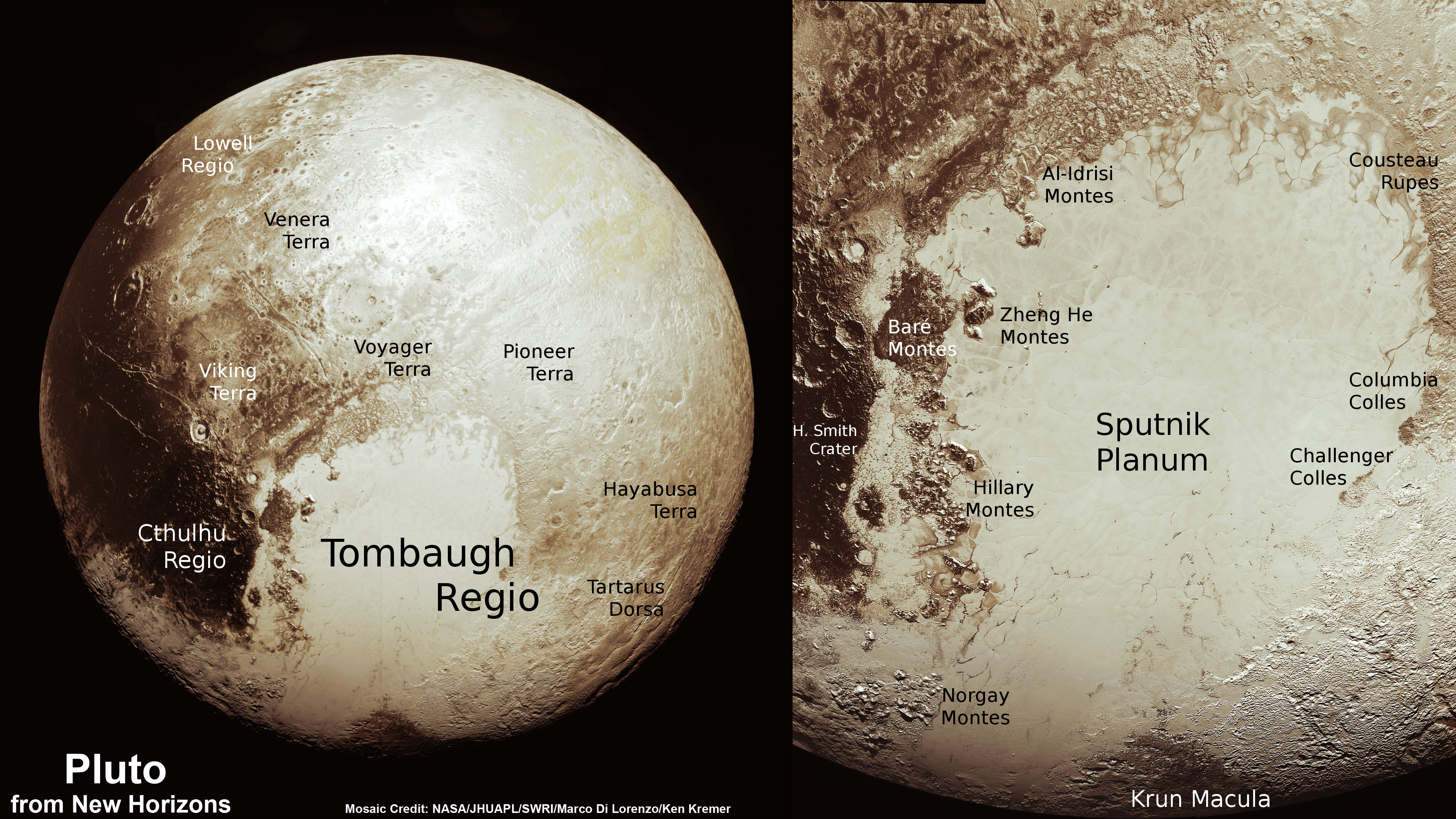
This new global mosaic view of Pluto was created from the latest high-resolution images to be downlinked from NASA’s New Horizons spacecraft and released on Sept. 11, 2015. The images were taken as New Horizons flew past Pluto on July 14, 2015, from a distance of 50,000 miles (80,000 kilometers). This mosaic was stitched from over two dozen raw images captured by the LORRI imager and colorized. Right side mosaic comprises twelve highest resolution views of Tombaugh Regio heart shaped feature and shows objects as small as 0.5 miles (0.8 kilometers) in size. Credits: NASA/Johns Hopkins University Applied Physics Laboratory/Southwest Research Institute/ Ken Kremer/kenkremer.com/Marco Di Lorenzo

Video caption: This animation of LORRI (Long Range Reconnaissance Imager) images begins with a low-altitude look at the informally named Norgay Montes, flies northward over the boundary between informally named Sputnik Planum and Cthulhu Regio, turns, and drifts slowly east above Pluto’s heart shaped Tombaugh Regio feature. It then rises about 10 times higher in altitude as NASA’s New Horizons flew closest to Pluto on July 14, 2015. Credit: NASA/JHUAPL/SwRI/Stuart Robbins. See additional high resolution global Pluto and Tombaugh Regio mosaics below

Imagine yourself as a once in a lifetime Plutonian tourist sailing along in a spartan spaceship and looking out the windows to breathtaking alien landscapes with cameras snapping away.

Now for the first time in human history, you can embark on a heretofore unimaginable flyover tour over Pluto – the most distant planetary system yet explored by an emissary from Earth, thanks to the team propelling NASA’s New Horizons spacecraft to the far flung reaches of our Solar System.

Just click on the video above and take the astounding aerial flyover tour above Pluto’s huge heart and the icy worlds wondrous array of tectonically active flow plains and majestic mountain ranges towering kilometers skyward to its thin hazy atmosphere.

The animation is a gift to humanity as seen from the perspective of the New Horizons probe as it flew past Pluto on July 14, 2015 at a distance of 50,000 miles (80,000 kilometers).

The new flyover video beautifully melds “art and science” – and is the brainchild of Stuart Robbins, a New Horizons research scientist at the Southwest Research Institute in Boulder, Colorado.

“I have used the latest images to produce an animation that shows what it might be like to take an aerial tour through Pluto’s thin atmosphere and soar above the surface that New Horizons explored,” Robbins explained in a blog posting.

The flyover animation is based on a stitched together mosaic of New Horizons images that were then rendered onto a sphere of Pluto. The animation and spherical mosaic were created by New Horizons team members using the initial batch of images taken by the LORRI (Long Range Reconnaissance Imager) camera and downloaded from the spacecraft as of Sept. 11, 2015.

“The mosaic …. provides an incredibly accurate portrayal of Pluto’s surface. It showcases …. the huge variety of terrain types that we see on Pluto.”

The flyover begins low over the heart shaped region of Pluto informally named Tombaugh Regio by the New Horizons team. The LORRI images at the starting point over the Norgay Montes mountain range have a resolution up to 400 meters per pixel at a altitude of only about 120 miles (200 kilometers). The resolution then changes to about 800 meters per pixel.

The animation concludes with images of approximately 2.1 kilometers per pixel as the apparent altitude increases tenfold to about 1,500 miles (2,500 kilometers) as viewers perspective changes from an up close view to one revealing Pluto’s disk rapidly growing to show about 80% of the hemisphere New Horizons flew closest to on July 14, 2015.

Here is Robbins explanation of the Plutonian terrain visible during your tourists eye view:

“Our tour starts low over the informally named Norgay Montes at a height of about 120 miles (200 kilometers). These jagged mountains rise almost 2 miles (3 kilometers) from the surrounding surface.”

“We head north over Sputnik Planum (bright area to the left) and Cthulhu Regio (dark area to the right). While Sputnik Planum is smooth at this pixel scale, it’s in marked contrast to Cthulhu Regio which has many large impact craters that indicate the Regio is much older. The differences in brightness are some of the largest natural brightness variations of any object in the solar system.”

“Our view steadily rises to a height of about 150 miles (240 kilometers) and turns to look east. From this point, we drift slowly to the east, with Pluto’s north pole to the left, Tombaugh Regio filling much of the middle of the view, and older, more cratered areas standing out in marked contrast to the younger glaciers of the “heart’s” left lobe, Sputnik Planum.”

“As we continue to fly, our flight path rises to more than 1,500 miles (2,500 kilometers) with the final view of most of the disk that New Horizons saw on July 14.”

Robbins role on the New Horizons science team is using the images “to map craters across the surfaces of Pluto and its largest moon, Charon, to understand the population of impactors from the Kuiper Belt striking Pluto and Charon.”

To see and study the whole disk of Pluto and the highest resolution view of the “heart” check out our global Pluto and Tombaugh Regio mosaics generated from raw images captured by New Horizons’ Long Range Reconnaissance Imager (LORRI) and stitched together by the image processing team of Marco Di Lorenzo and Ken Kremer.
New Horizon’s unveiled Pluto as a surprisingly vibrant and geologically active “icy world of wonders” as it barreled past the Pluto-Charon double planet system on July 14 at over 31,000 mph (49,600 kph) and collected unprecedented high resolution imagery and spectral measurements of the utterly alien worlds.

What are Pluto’s newly discovered plains and mountains composed of?

“The plains are made of nitrogen. But nitrogen is too soft a material to build mountains out of, even in Pluto’s weak gravity,” says New Horizons Principal Investigator Alan Stern of the Southwest Research Institute, Boulder, Colorado.

“So the mountains must be made of something else stronger. Rock and water ice are the two most likely possibilities. But they are most likely water ice.”

Here’s our colorized and annotated version of the recently released backlit view of Pluto taken 15 minutes after closest approach as New Horizons spacecraft looked back toward the sun and captured a near-sunset view of the rugged, icy mountains and flat ice plains extending to Pluto’s horizon.
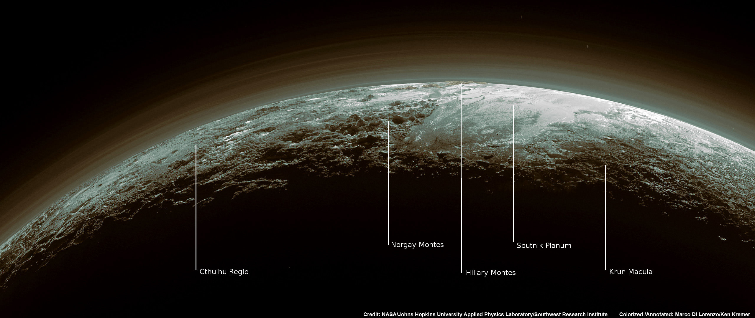
Just 15 minutes after its closest approach to Pluto on July 14, 2015, NASA's New Horizons spacecraft looked back toward the sun and captured this near-sunset view of the rugged, icy mountains and flat ice plains extending to Pluto's horizon - shown in this colorized rendition. The smooth expanse of the informally named icy plain Sputnik Planum (right) is flanked to the west (left) by rugged mountains up to 11,000 feet (3,500 meters) high, including the informally named Norgay Montes in the foreground and Hillary Montes on the skyline. To the right, east of Sputnik, rougher terrain is cut by apparent glaciers. The backlighting highlights more than a dozen layers of haze in Pluto’s tenuous but distended atmosphere. The image was taken from a distance of 11,000 miles (18,000 kilometers) to Pluto; the scene is 780 miles (1,250 kilometers) wide. Credit: NASA/Johns Hopkins University Applied Physics Laboratory/Southwest Research Institute. Colorized/Annotated: Marco Di Lorenzo/Ken Kremer/kenkremer.com
Just 15 minutes after its closest approach to Pluto on July 14, 2015, NASA’s New Horizons spacecraft looked back toward the sun and captured this near-sunset view of the rugged, icy mountains and flat ice plains extending to Pluto’s horizon – shown in this colorized rendition. The smooth expanse of the informally named icy plain Sputnik Planum (right) is flanked to the west (left) by rugged mountains up to 11,000 feet (3,500 meters) high, including the informally named Norgay Montes in the foreground and Hillary Montes on the skyline. To the right, east of Sputnik, rougher terrain is cut by apparent glaciers. The backlighting highlights more than a dozen layers of haze in Pluto’s tenuous but distended atmosphere. The image was taken from a distance of 11,000 miles (18,000 kilometers) to Pluto; the scene is 780 miles (1,250 kilometers) wide. Credit: NASA/Johns Hopkins University Applied Physics Laboratory/Southwest Research Institute. Colorized/Annotated: Marco Di Lorenzo/Ken Kremer/kenkremer.com

Since the flyby, the team has been busy analyzing the science data returned thus far and “making some discoveries” says Stern.

“Pluto is showing us a diversity of landforms and complexity of processes that rival anything we’ve seen in the solar system.”

“If an artist had painted this Pluto before our flyby, I probably would have called it over the top — but that’s what is actually there.”

New Horizons gathered about 50 gigabits of data as it hurtled past Pluto, its largest moon Charon and four smaller moons.

New Horizons also discovered that Pluto is the biggest object in the outer solar system and thus the ‘King of the Kuiper Belt’.

The Kuiper Belt comprises the third and outermost region of worlds in our solar system.

Only about 5 to 6 percent has been downlinked to Earth so far. Stern says it will take about a year for all the data to get back.

So expect a year of endless treats and surprises from the ‘King of the Kuiper Belt’!
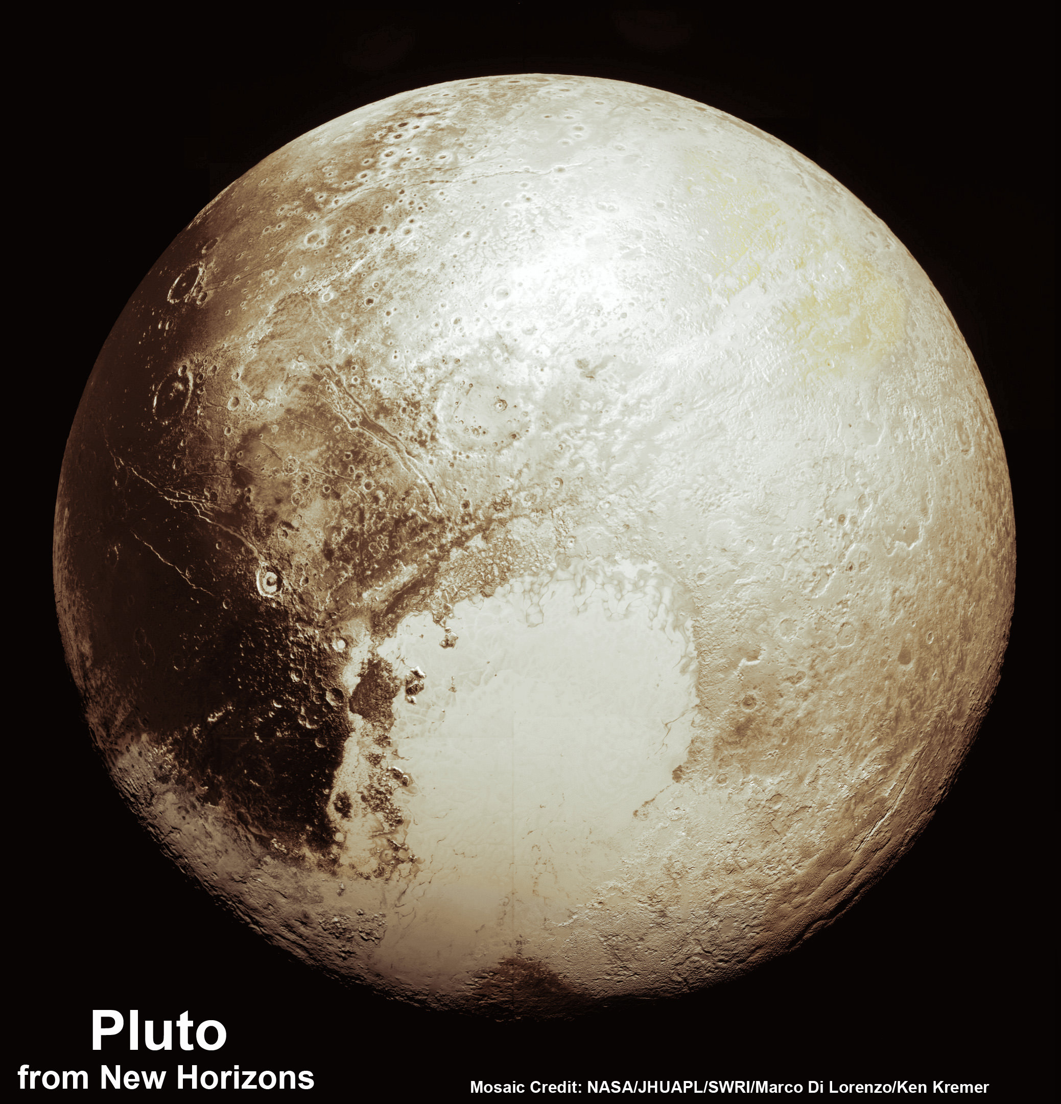
This new global mosaic view of Pluto was created from the latest high-resolution images to be downlinked from NASA’s New Horizons spacecraft and released on Sept. 11, 2015.   The images were taken as New Horizons flew past Pluto on July 14, 2015, from a distance of 50,000 miles (80,000 kilometers).  This new mosaic was stitched from over two dozen raw images captured by the LORRI imager and colorized.  Credits: NASA/Johns Hopkins University Applied Physics Laboratory/Southwest Research Institute/Marco Di Lorenzo/Ken Kremer/kenkremer.com
This new global mosaic view of Pluto was created from the latest high-resolution images to be downlinked from NASA’s New Horizons spacecraft and released on Sept. 11, 2015. The images were taken as New Horizons flew past Pluto on July 14, 2015, from a distance of 50,000 miles (80,000 kilometers). This new mosaic was stitched from over two dozen raw images captured by the LORRI imager and colorized. Credits: NASA/Johns Hopkins University Applied Physics Laboratory/Southwest Research Institute/Marco Di Lorenzo/Ken Kremer/kenkremer.com

Watch for Ken’s continuing coverage of the Pluto flyby. He was onsite reporting live on the flyby and media briefings for Universe Today from the Johns Hopkins University Applied Physics Laboratory (APL), in Laurel, Md.

Stay tuned here for Ken’s continuing Earth and planetary science and human spaceflight news.

Ken Kremer

Pluto Spectacular! Glaciers, Hazes, Majestic Peaks Revealed in New Photos

Pluto’s Majestic Mountains, Frozen Plains and Foggy Hazes: Just 15 minutes after its closest approach to Pluto on July 14, 2015, NASA’s New Horizons spacecraft looked back toward the sun and captured this near-sunset view of the rugged, icy mountains and flat ice plains extending to Pluto’s horizon. The smooth expanse of the informally named icy plain Sputnik Planum (right) is flanked to the west (left) by rugged mountains up to 11,000 feet (3,500 meters) high, including the informally named Norgay Montes in the foreground and Hillary Montes on the skyline. To the right, east of Sputnik, rougher terrain is cut by apparent glaciers. The backlighting highlights over a dozen layers of haze in Pluto’s tenuous but distended atmosphere. The image was taken from a distance of 11,000 miles (18,000 kilometers) to Pluto; the scene is 780 miles (1,250 kilometers) wide. Credits: NASA/JHUAPL/SwRI

As the hazy, lazy days of summer come to a close, the New Horizons team released a brand new set of incredible images of a very atmospheric Pluto.

Can you believe the detail in these photos? Back-lit by the Sun, we see icy plains, rugged mountains, glacier-cut terrain and multiple layers of haze just like those on a steamy August afternoon.

Closer Look: Majestic Mountains and Frozen Plains: Just 15 minutes after its closest approach to Pluto on July 14, 2015, NASA’s New Horizons spacecraft looked back toward the sun and captured this near-sunset view of the rugged, icy mountains and flat ice plains extending to Pluto’s horizon. The smooth expanse of the informally named Sputnik Planum (right) is flanked to the west (left) by rugged mountains up to 11,000 feet (3,500 meters) high, including the informally named Norgay Montes in the foreground and Hillary Montes on the skyline. The backlighting highlights more than a dozen layers of haze in Pluto’s tenuous but distended atmosphere. The image was taken from a distance of 11,000 miles (18,000 kilometers) to Pluto; the scene is 230 miles (380 kilometers) across. Credits: NASA/JHUAPL/SwRI)
Just look at those pyramidal mountain peaks right next to those relatively smooth, icy plains. The backlighting highlights more than a dozen layers of haze in Pluto’s tenuous but distended atmosphere. The image was taken from a distance of 11,000 miles (18,000 km) to Pluto; the scene is 230 miles (380 km) across.
Credits: NASA/JHUAPL/SwRI)

The scene measures 780 miles (1,250 kilometers) across and was taken from a distance of 11,000 miles (18,000 km) on July 15 just after closest approach. Because backlighting highlights fine aerosols suspended in the atmosphere (think of seeing your breath on a cold winter day against the Sun), these photos show the amazing complexity of Pluto’s atmosphere with more than a dozen thin haze layers extending from near the ground to at least 60 miles (100 km) above the surface.

Near-Surface Haze or Fog on Pluto: In this small section of the larger crescent image of Pluto, taken by NASA’s New Horizons just 15 minutes after the spacecraft’s closest approach on July 14, 2015, the setting sun illuminates a fog or near-surface haze, which is cut by the parallel shadows of many local hills and small mountains. The image was taken from a distance of 11,000 miles (18,000 kilometers), and the width of the image is 115 miles (185 kilometers). Credits: NASA/JHUAPL/SwRI
 In this small section of the larger crescent image of Pluto, the setting sun illuminates a bank of fog or low-lying near-surface haze sliced by the parallel shadows of many local hills and small mountains. The image was taken from a distance of 11,000 miles (18,000 km), and the width of the image is 115 miles (185 km).
Credits: NASA/JHUAPL/SwRI

“This image really makes you feel you are there, at Pluto, surveying the landscape for yourself,” said New Horizons Principal Investigator Alan Stern in a press release today. “But this image is also a scientific bonanza, revealing new details about Pluto’s atmosphere, mountains, glaciers and plains.”

Sputnik Planum is the informal name of the smooth, light-bulb shaped region on the left of this composite of several New Horizons images of Pluto. The brilliantly white upland region to the right may be coated by nitrogen ice that has been transported through the atmosphere from the surface of Sputnik Planum, and deposited on these uplands. The box shows the location of the glacier detail images below. Credits: NASA/JHUAPL/SwRI
Sputnik Planum is the informal name of the smooth, light-bulb shaped region on the left of this composite of several New Horizons images of Pluto. The brilliantly white upland region to the right may be coated by nitrogen ice that has been transported through the atmosphere from the surface of Sputnik Planum, and deposited on these uplands. The box shows the location of the glacier detail images below.
Credits: NASA/JHUAPL/SwRI

I find the hazes the most amazing aspect of the photos. They remind me of crepuscular rays, those beams of sunshine that shine between breaks in the clouds near sunset and sunrise. It chills and thrills me to the bone to see such earthly sights on a bitterly cold orb more than 3 billion miles from home.

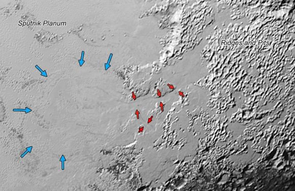
Ice, probably frozen nitrogen, appears to have accumulated on the uplands on the right side of this 390-mile (630-km) wide image is draining from Pluto’s mountains onto the informally named Sputnik Planum through the 2- to 5-mile (3- to 8-km) wide valleys indicated by the red arrows. On Earth this would be considered a valley glacier. The flow front of the ice moving into Sputnik Planum is outlined by the blue arrows. The origin of the ridges and pits on the right side of the image remains uncertain. Credits: NASA/JHUAPL/SwRI
Ice, probably frozen nitrogen, appears to have accumulated on the uplands on the right side of this 390-mile (630-km) wide image is draining from Pluto’s mountains onto the informally named Sputnik Planum through the 2- to 5-mile (3- to 8-km) wide valleys indicated by the red arrows. On Earth this would be considered a valley glacier. The flow front of the ice moving into Sputnik Planum is outlined by the blue arrows. The origin of the ridges and pits on the right side of the image remains uncertain.
Credits: NASA/JHUAPL/SwRI

But that’s not all that’s close to our hearts on Pluto. The photos reveal nitrogen ice apparently flowing downhill from mountainous highlands into a broad, smooth basin. Combined with other recently downloaded pictures, this new image (above) provides evidence for a remarkably Earth-like “hydrological” cycle on Pluto – but involving soft and exotic ices, including nitrogen, rather than water ice.

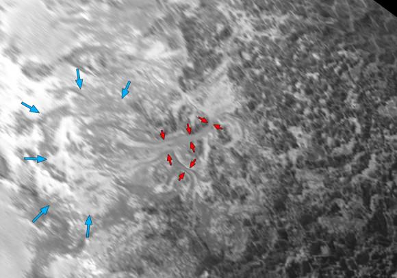
This might be the most remarkable image of all. Intricate Valley Glaciers on Pluto: This image covers the same region as the image above, but is re-projected from the oblique, backlit view shown in the new crescent image of Pluto. The backlighting highlights the intricate flow lines on the glaciers. The flow front of the ice moving into the informally named Sputnik Planum is outlined by the blue arrows. The origin of the ridges and pits on the right side of the image remains uncertain. This image is 390 miles (630 kilometers) across. Credits: NASA/JHUAPL/SwRI
This might be the most remarkable image of all. It covers the same region as the image above, but is re-projected from the oblique, backlit view shown in the new crescent image of Pluto. The backlighting highlights the intricate flow lines on the valley glaciers. The flow front of the ice moving into the informally named Sputnik Planum is outlined by the blue arrows. We’re looking at a scene 390 miles (630 km) across.
Credits: NASA/JHUAPL/SwRI

Nitrogen ice in the vast, relatively smooth Sputnik Planum may have vaporized in sunlight and then redeposited as ice in the bright, rugged region to its east. The new Ralph imager panorama also reveals glaciers flowing back from the blanketed mountain region into Sputnik Planum; these features are similar to the frozen streams on the margins of ice caps on Greenland and Antarctica.

Who knew that by going to Pluto we’d see such familiarity? But there you have it.

Global Pluto Mosaic From New Hi Res Imagery Reveals Bewildering Diversity and Complexity

This new global mosaic view of Pluto was created from the latest high-resolution images to be downlinked from NASA’s New Horizons spacecraft and released on Sept. 11, 2015. The images were taken as New Horizons flew past Pluto on July 14, 2015, from a distance of 50,000 miles (80,000 kilometers). This new mosaic was stitched from over two dozen raw images captured by the LORRI imager and colorized. Credits: NASA/Johns Hopkins University Applied Physics Laboratory/Southwest Research Institute/Marco Di Lorenzo/Ken Kremer/kenkremer.com

This new global mosaic view of Pluto was created from the latest high-resolution images to be downlinked from NASA’s New Horizons spacecraft and released on Sept. 11, 2015. The images were taken as New Horizons flew past Pluto on July 14, 2015, from a distance of 50,000 miles (80,000 kilometers). This new mosaic was stitched from over two dozen raw images captured by the LORRI imager and colorized. Credits: NASA/Johns Hopkins University Applied Physics Laboratory/Southwest Research Institute/Marco Di Lorenzo/Ken Kremer/kenkremer.com
See annotated version and new hi res Tombaugh Regio mosaic below[/caption]

A new global mosaic of Pluto created from the latest high resolution images just beamed back from NASA’s New Horizons probe reveals a bewildering diversity of planetary landforms with unimaginable complexity – yielding undreamed of science discoveries.

But because of limited bandwidth the new image data sets were stored onboard the probe until days ago when they were transmitted back to Earth and released by the New Horizons team late in the day on Friday, Sept. 11.

This best yet view of far flung Pluto comes from raw images taken as New Horizons conducted the history making first flyby past Pluto on July 14, 2015, at a distance of 50,000 miles (80,000 kilometers).

The global Pluto mosaic was generated from over two dozen raw images captured by New Horizons’ Long Range Reconnaissance Imager (LORRI) and stitched together by the image processing team of Marco Di Lorenzo and Ken Kremer.

See also our expanded hi res Tombaugh Regio mosaic below showing features as small as 0.5 miles (0.8 kilometers) in size.

After transmitting carefully selected high priority images and science measurements across over 3 billion miles (about 5 billion kilometers) of interplanetary space in the days around the history making flyby, the team elected to temporarily pause the transmission of new images for several weeks in favor of sending other data important for helping place the entire Pluto planetary system into context.

Altogether, over 50 gigabits of data were collected during the July 14 encounter and flyby periods of the highest scientific activity – which includes the most critical hours before and after the spacecrafts closest approach to Pluto, its largest moon Charon and its quartet of smaller moons.

Highest resolution mosaic of ‘Tombaugh Regio’ shows the heart-shaped region on Pluto including ice flows and plains of ‘Sputnik Planum’ (center) and icy mountain ranges of ‘Hillary Montes’ and ‘Norgay Montes.’  This new mosaic combines the eleven highest resolution images captured by NASA’s New Horizons LORRI imager during history making closest approach flyby on July 14, 2015.   Credit: NASA/JHUAPL/SWRI/Ken Kremer/kenkremer.com/Marco Di Lorenzo
Highest resolution mosaic of ‘Tombaugh Regio’ shows the heart-shaped region on Pluto including ice flows and plains of ‘Sputnik Planum’ (center) and icy mountain ranges of ‘Hillary Montes’ and ‘Norgay Montes.’ This new mosaic combines the eleven highest resolution images captured by NASA’s New Horizons LORRI imager during history making closest approach flyby on July 14, 2015. It shows features as small as 0.5 miles (0.8 kilometers) in size. Credit: NASA/JHUAPL/SWRI/Ken Kremer/kenkremer.com/Marco Di Lorenzo

Data from the flyby continues streaming back to Earth, but rather slowly due to limited bandwidth amounting to an average “downlink” of only about 2 kilobits per second via its two transmitters.

New Horizon’s unveiled Pluto as a surprising vibrant and geologically active “icy world of wonders” as it barreled past the Pluto-Charon double planet system on July 14 at over 31,000 mph (49,600 kph) and collected unprecedented high resolution imagery and spectral measurements of the utterly alien worlds.

Since the flyby, the team has been busy analyzing the science data returned thus far and “making some discoveries” said New Horizons Principal Investigator Alan Stern of the Southwest Research Institute, Boulder, Colorado, during the Weekly Space Hangout on Sept 11.

The team is ecstatic with all the new images and created what they call a synthetic global view of a portion of Pluto.

“We created a synthetic global mosaic view of more than a dozen frames from the LORRI camera, and wrapped it on a sphere and then projected the view as if you were suspended about a thousand miles above the planet – looking back.”

Each LORRI frame is about 400 km across.

This new mosaic of Pluto is from the  latest high-resolution images sent to Earth from the New Horizons spacecraft  shows what you would see if you were approximately 1,100 miles (1,800 kilometers) above Pluto’s equatorial area, looking northeast over the dark, cratered, informally named Cthulhu Regio toward the bright, smooth, expanse of icy plains informally called Sputnik Planum. The entire expanse of terrain seen in this image is 1,100 miles (1,800 kilometers) across. The images were taken as New Horizons flew past Pluto on July 14, 2015, from a distance of 50,000 miles (80,000 kilometers). Credit: NASA/Johns Hopkins University Applied Physics Laboratory/Southwest Research Institute
This new mosaic of Pluto is from the latest high-resolution images sent to Earth from the New Horizons spacecraft shows what you would see if you were approximately 1,100 miles (1,800 kilometers) above Pluto’s equatorial area, looking northeast over the dark, cratered, informally named Cthulhu Regio toward the bright, smooth, expanse of icy plains informally called Sputnik Planum. The entire expanse of terrain seen in this image is 1,100 miles (1,800 kilometers) across. The images were taken as New Horizons flew past Pluto on July 14, 2015, from a distance of 50,000 miles (80,000 kilometers). Credit: NASA/Johns Hopkins University Applied Physics Laboratory/Southwest Research Institute

“It gives a breathtaking view of how diverse the geology is and also how diverse the seasonal volatile transport must be across the surface.”

“It’s just absolutely magical and breathtaking. There is a lot going on there.”

“The big bright area on the left side of the heart shaped feature is informally called Sputnik Planum after the first spacecraft – Sputnik. Surrounding the Texas sized plain are steep mountain ranges that are as tall as the Rockies in Colorado.”

What are Pluto’s plains and mountains comprised of?

“We know that the mountain ranges are not made of the same stuff as the planum, or plains. The plains are made of nitrogen. But nitrogen is too soft a material to build mountains out of, even in Pluto’s weak gravity.”

“So the mountains must be made of something else stronger. Rock and water ice are the two most likely possibilities. But they are most likely water ice, the lighter stuff. Because the rock has almost certainly sunk to the center of Pluto and the ice has floated to the top and formed the mantle and perhaps the crust of Pluto.”

“So we think the volatiles like the nitrogen, methane and carbon monoxide you see there and that shifts around with the seasons and interacts with the atmosphere – is just a veneer. It’s just a coating on the surface. And in some places its very thin and looks like it is breaking up on the margins. In other places it may be quite thick, maybe even kilometers thick.”

“We’ll see when we have more data!” exclaimed Stern.

“The data downlink will take over a year to get all the data to the ground [on Earth].”

“Over 50 gigabits of science data from the Pluto system needs to be sent back. The Pluto flyby took place on the 50th anniversary of NASA’s first flyby of Mars by Mariner IV. New Horizons dataset amounted to several thousand times more data collected compared to what Mariner IV sent back during its first flyby of Mars,” Stern elaborated.

“The surface of Pluto is every bit as complex as that of Mars,” says Jeff Moore, leader of the New Horizons Geology, Geophysics and Imaging (GGI) team at NASA’s Ames Research Center in Moffett Field, California. “The randomly jumbled mountains might be huge blocks of hard water ice floating within a vast, denser, softer deposit of frozen nitrogen within the region informally named Sputnik Planum.”

How much data has been returned so far varies by instrument.

“The average across all the entire science payload is only about 5 or 6 percent so far,” Stern explained.

“All the flyby data from the two plasma instruments – PEPSI and SWAP – and the Student Dust Counter instrument is back on the ground, because they were small datasets.”

“But less than 3% of the ALICE UV spectrometer data is back so far. And for the other imaging instruments its similar.”

“So it’s going to take about another year to send all the data back!”

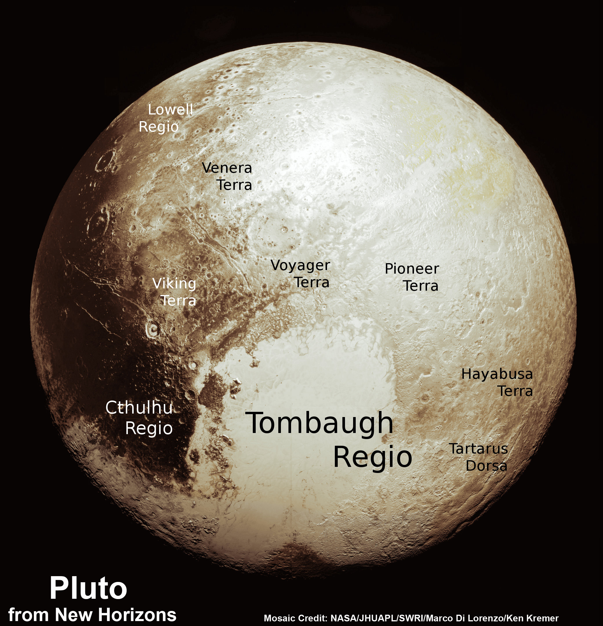
This new global mosaic view of Pluto was created from the latest high-resolution images to be downlinked from NASA’s New Horizons spacecraft and released on Sept. 11, 2015.   The images were taken as New Horizons flew past Pluto on July 14, 2015, from a distance of 50,000 miles (80,000 kilometers).  This new mosaic was stitched from over two dozen raw images captured by the LORRI imager and colorized.  Annotated with informal place names.  Credits: NASA/Johns Hopkins University Applied Physics Laboratory/Southwest Research Institute/Marco Di Lorenzo/Ken Kremer/kenkremer.com
This new global mosaic view of Pluto was created from the latest high-resolution images to be downlinked from NASA’s New Horizons spacecraft and released on Sept. 11, 2015. The images were taken as New Horizons flew past Pluto on July 14, 2015, from a distance of 50,000 miles (80,000 kilometers). This new mosaic was stitched from over two dozen raw images captured by the LORRI imager and colorized. Annotated with informal place names. Credits: NASA/Johns Hopkins University Applied Physics Laboratory/Southwest Research Institute/Marco Di Lorenzo/Ken Kremer/kenkremer.com

Stern informed that the team has submitted a paper to the journal Science and plans a large series of technical scientific presentations at upcoming meetings, including the Division of Planetary Sciences Meeting in Washington in November.

And New Horizons is in excellent shape to get those 50 gigabits of data back to the eagerly waiting researchers since all the spacecraft systems are operating normally.

“The spacecraft is doing very well,” said Alice Bowman, New Horizons Mission Operations Manager of the Johns Hopkins University Applied Physics Laboratory (APL), during the Weekly Space Hangout.

“It’s very healthy and we are getting back gobs of data – causing a flurry of emails among the science team.”

“It’s been a good ride and we had a good flyby of Jupiter too [along the way].”

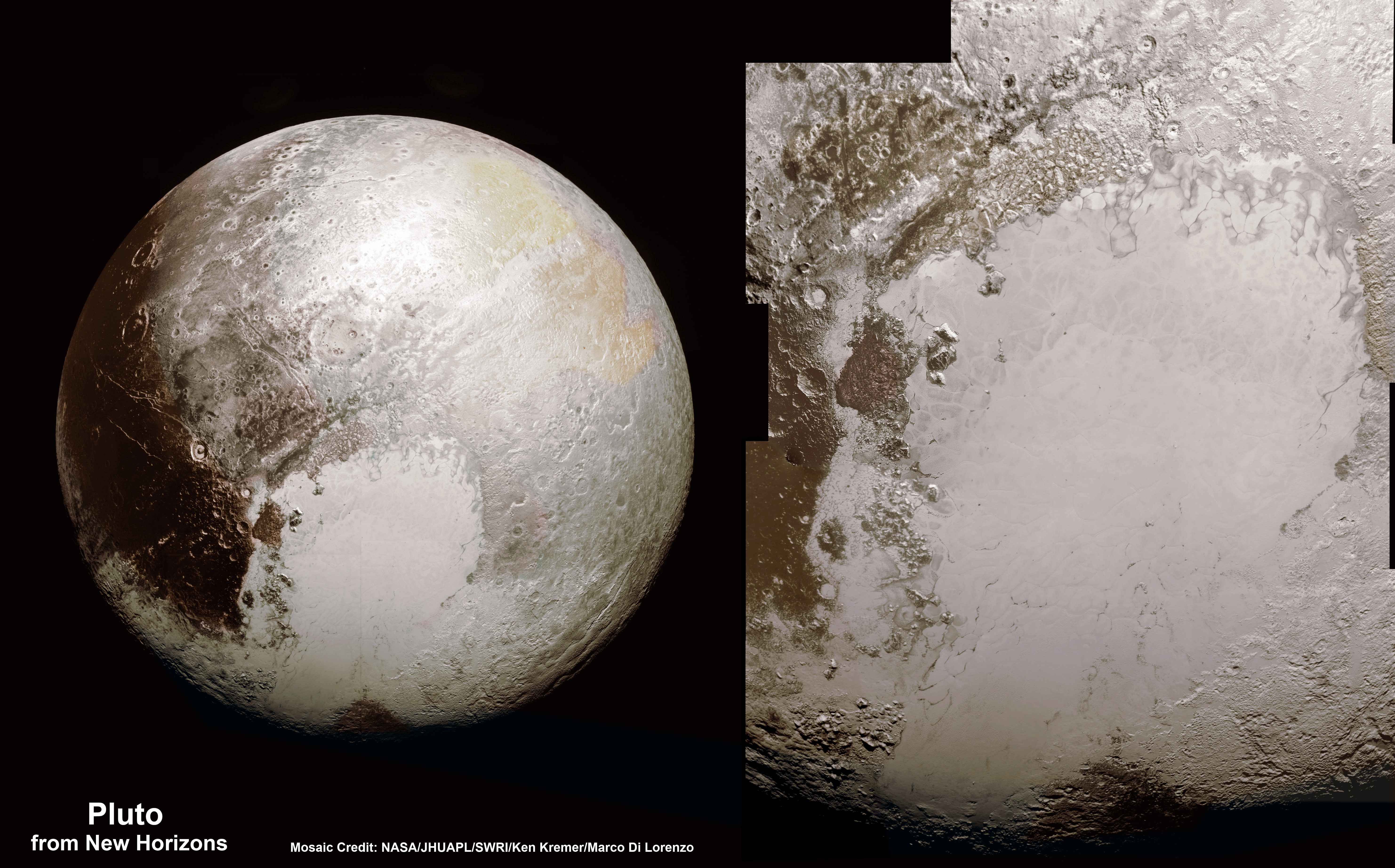
This new global mosaic view of Pluto was created from the latest high-resolution images to be downlinked from NASA’s New Horizons spacecraft and released on Sept. 11, 2015.   The images were taken as New Horizons flew past Pluto on July 14, 2015, from a distance of 50,000 miles (80,000 kilometers).  This mosaic was stitched from over two dozen raw images captured by the LORRI imager and colorized.  Right side mosaic comprises twelve highest resolution views of Tombaugh Regio heart shaped feature and shows objects as small as 0.5 miles (0.8 kilometers) in size.  Credits: NASA/Johns Hopkins University Applied Physics Laboratory/Southwest Research Institute/ Ken Kremer/kenkremer.com/Marco Di Lorenzo
This new global mosaic view of Pluto was created from the latest high-resolution images to be downlinked from NASA’s New Horizons spacecraft and released on Sept. 11, 2015. The images were taken as New Horizons flew past Pluto on July 14, 2015, from a distance of 50,000 miles (80,000 kilometers). This mosaic was stitched from over two dozen raw images captured by the LORRI imager and colorized. Right side mosaic comprises twelve highest resolution views of Tombaugh Regio heart shaped feature and shows objects as small as 0.5 miles (0.8 kilometers) in size. Credits: NASA/Johns Hopkins University Applied Physics Laboratory/Southwest Research Institute/ Ken Kremer/kenkremer.com/Marco Di Lorenzo

New Horizons also discovered that Pluto is the largest known body beyond Neptune – and thus reigns as the “King of the Kuiper Belt!”

As of today, Sept. 14, New Horizons is 2 months past the Pluto flyby and already over 73 million kilometers ( over 45 million miles) beyond Pluto and continuing its journey into the Kuiper Belt, the third realm of worlds in our solar system.

The science team plans to target New Horizons to fly by another much smaller Kuiper Belt Object (KBO) in 2019 after recently selecting the object dubbed PT1, for Potential Target 1, based on images taken by NASA’s Hubble Space Telescope.

“Since the flyby, we have been planning for the extended mission which we will propose to NASA next year,” Stern explained. NASA will then decide whether to approve and fund the new KBO mission proposal.

“We expect to do an engine burn for that [new KBO target] next month [in October]. The KBO flyby will take place about a billion miles beyond Pluto at about 44 AU.”

The actual flyby distance of New Horizons from the KBO is yet to be determined. Stern thinks it could perhaps be much closer, but all those details still need to be worked out.

NASA Associate Administrator for the Science Mission Directorate John Grunsfeld, left, New Horizons Principal Investigator Alan Stern of Southwest Research Institute (SwRI), Boulder, CO, second from left, New Horizons Mission Operations Manager Alice Bowman of the Johns Hopkins University Applied Physics Laboratory (APL), second from right, and New Horizons Project Manager Glen Fountain of APL, right, are seen at the conclusion of a press conference after the team received confirmation from the spacecraft that it has completed the flyby of Pluto, Tuesday, July 14, 2015 at the Johns Hopkins University Applied Physics Laboratory (APL) in Laurel, Maryland. Credit:  Ken Kremer/kenkremer.com
NASA Associate Administrator for the Science Mission Directorate John Grunsfeld, left, New Horizons Principal Investigator Alan Stern of Southwest Research Institute (SwRI), Boulder, CO, second from left, New Horizons Mission Operations Manager Alice Bowman of the Johns Hopkins University Applied Physics Laboratory (APL), second from right, and New Horizons Project Manager Glen Fountain of APL, right, are seen at the conclusion of a press conference after the team received confirmation from the spacecraft that it has completed the flyby of Pluto, Tuesday, July 14, 2015 at the Johns Hopkins University Applied Physics Laboratory (APL) in Laurel, Maryland. Credit: Ken Kremer/kenkremer.com

Watch for Ken’s continuing coverage of the Pluto flyby. He was onsite reporting live on the flyby and media briefings for Universe Today from the Johns Hopkins University Applied Physics Laboratory (APL), in Laurel, Md.

Stay tuned here for Ken’s continuing Earth and planetary science and human spaceflight news.
Ken Kremer

Pluto Explored at Last. The New Horizons mission team celebrates successful flyby of Pluto in the moments after closest approach at 7:49 a.m. EDT on July 14, 2015.   New Horizons Principal Investigator Alan Stern of Southwest Research Institute (SwRI), Boulder, CO., left, Johns Hopkins University Applied Physics Laboratory (APL) Director Ralph Semmel, center, and New Horizons Co-Investigator Will Grundy Lowell Observatory hold an enlarged print of an U.S. stamp with their suggested update after Pluto became the final planet in our solar system to be explored by an American space probe (crossing out the words ‘not yet’) - at the Johns Hopkins University Applied Physics Laboratory (APL) in Laurel, Maryland.  Credit: Ken Kremer/kenkremer.com
Pluto Explored at Last
The New Horizons mission team celebrates successful flyby of Pluto in the moments after closest approach at 7:49 a.m. EDT on July 14, 2015. New Horizons Principal Investigator Alan Stern of Southwest Research Institute (SwRI), Boulder, CO., left, Johns Hopkins University Applied Physics Laboratory (APL) Director Ralph Semmel, center, and New Horizons Co-Investigator Will Grundy Lowell Observatory hold an enlarged print of an U.S. stamp with their suggested update after Pluto became the final planet in our solar system to be explored by an American space probe (crossing out the words ‘not yet’) – at the Johns Hopkins University Applied Physics Laboratory (APL) in Laurel, Maryland. Credit: Ken Kremer/kenkremer.com
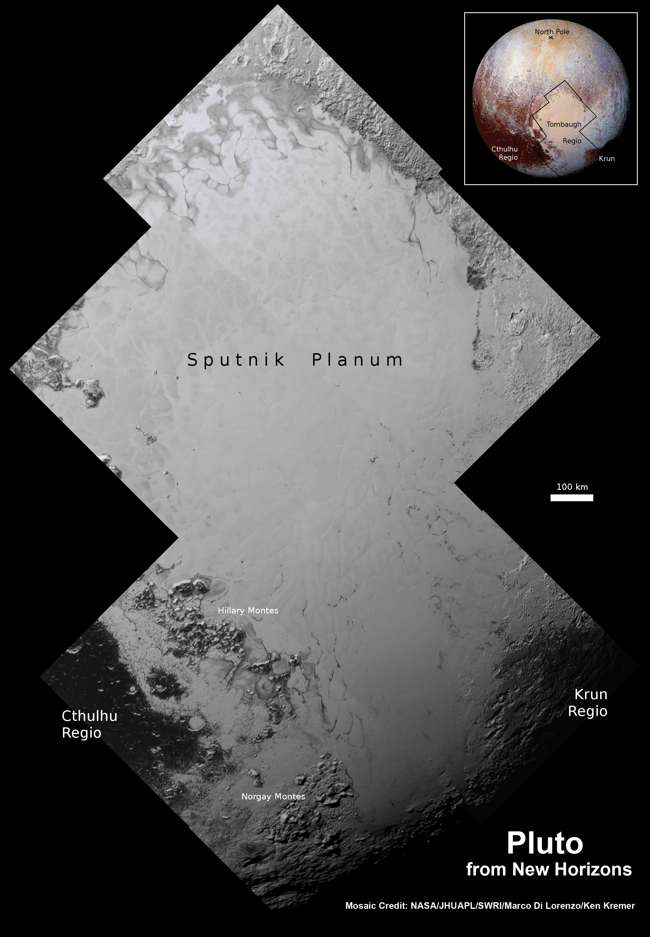
Highest resolution mosaic of ‘Tombaugh Regio’ shows the heart-shaped region on Pluto focusing on ice flows and plains of ‘Sputnik Planum’ at top and icy mountain ranges of ‘Hillary Montes’ and ‘Norgay Montes’ below.  This new mosaic combines the seven highest resolution images captured by NASA’s New Horizons LORRI imager during history making closest approach flyby on July 14, 2015.  Inset at right shows global view of Pluto with location of mosaic and huge heart-shaped region in context.  Annotated with place names.  Credit: NASA/JHUAPL/SWRI/ Marco Di Lorenzo/Ken Kremer/kenkremer.com
Highest resolution mosaic of ‘Tombaugh Regio’ shows the heart-shaped region on Pluto focusing on ice flows and plains of ‘Sputnik Planum’ at top and icy mountain ranges of ‘Hillary Montes’ and ‘Norgay Montes’ below. This new mosaic combines the seven highest resolution images captured by NASA’s New Horizons LORRI imager during history making closest approach flyby on July 14, 2015. Inset at right shows global view of Pluto with location of mosaic and huge heart-shaped region in context. Annotated with place names. Credit: NASA/JHUAPL/SWRI/ Marco Di Lorenzo/Ken Kremer/kenkremer.com
This new global mosaic view of Pluto was created from the latest high-resolution images to be downlinked from NASA’s New Horizons spacecraft and released on Sept. 11, 2015.   The images were taken as New Horizons flew past Pluto on July 14, 2015, from a distance of 50,000 miles (80,000 kilometers).  This new mosaic was stitched from over two dozen raw images captured by the LORRI imager and colorized.  Right side inset from New Horizons team focuses on Tombaugh Regio heart shaped feature.  Annotated with informal place names.  Credits: NASA/Johns Hopkins University Applied Physics Laboratory/Southwest Research Institute/Marco Di Lorenzo/Ken Kremer/kenkremer.com
This new global mosaic view of Pluto was created from the latest high-resolution images to be downlinked from NASA’s New Horizons spacecraft and released on Sept. 11, 2015. The images were taken as New Horizons flew past Pluto on July 14, 2015, from a distance of 50,000 miles (80,000 kilometers). This new mosaic was stitched from over two dozen raw images captured by the LORRI imager and colorized. Right side inset from New Horizons team focuses on Tombaugh Regio heart shaped feature. Annotated with informal place names. Credits: NASA/Johns Hopkins University Applied Physics Laboratory/Southwest Research Institute/Marco Di Lorenzo/Ken Kremer/kenkremer.com

Weekly Space Hangout – Sept 11, 2015: New Horizons Pluto-Palooza!

Host: Fraser Cain (@fcain)

Special Guests: New Horizons staff Dr. Alan Stern, Principal Investigator; Alice Bowman, Mission Operations Manager; and Emily Lakdawalla from The Planetary Society

Guests:
Brian Koberlein (@briankoberlein / briankoberlein.com)
Morgan Rehnberg (cosmicchatter.org / @MorganRehnberg )
Alessondra Springmann (@sondy)
Dave Dickinson (@astroguyz / www.astroguyz.com)
Nicole Gugliucci (cosmoquest.org / @noisyastronomer)
Ramin Skibba (@raminskibba)
Continue reading “Weekly Space Hangout – Sept 11, 2015: New Horizons Pluto-Palooza!”

New Pluto Images Show Possible Dunes, Crepuscular Rays, Unimaginable Complexity

This new mosaic of Pluto is from the latest high-resolution images sent to Earth from the New Horizons spacecraft shows what you would see if you were approximately 1,100 miles (1,800 kilometers) above Pluto’s equatorial area, looking northeast over the dark, cratered, informally named Cthulhu Regio toward the bright, smooth, expanse of icy plains informally called Sputnik Planum. The entire expanse of terrain seen in this image is 1,100 miles (1,800 kilometers) across. The images were taken as New Horizons flew past Pluto on July 14, 2015, from a distance of 50,000 miles (80,000 kilometers). Credit: NASA/Johns Hopkins University Applied Physics Laboratory/Southwest Research Institute

New Horizons scientists say they are “reeling” from the new images sent back from the spacecraft which were released today. The new data set shows an amazing range of complex features on Pluto’s surface and in its atmosphere.

New images show there might even be a field of dark wind-blown dunes, among other possibilities.

“Seeing dunes on Pluto — if that is what they are — would be completely wild, because Pluto’s atmosphere today is so thin,” said William B. McKinnon, a GGI deputy lead from Washington University, St. Louis. “Either Pluto had a thicker atmosphere in the past, or some process we haven’t figured out is at work. It’s a head-scratcher.”

Plus, a new view of Pluto’s hazy backlit atmosphere shows what are likely crepuscular rays — shadows cast on the haze by topography such as mountain ranges on Pluto, similar to the rays sometimes seen in the sky after the sun sets behind mountains on Earth.

Two different versions of an image of Pluto's haze layers, taken by New Horizons as it looked back at Pluto's dark side nearly 16 hours after close approach, from a distance of 480,000 miles (770,000 kilometers). The left version has had only minor processing, while the right version has been specially processed to reveal a large number of discrete haze layers in the atmosphere, and and subtle parallel streaks in the haze may be crepuscular rays- shadows cast on the haze by topography such as mountain ranges on Pluto, similar to the rays sometimes seen in the sky after the sun sets behind mountains on Earth. Credit: NASA/Johns Hopkins University Applied Physics Laboratory/Southwest Research Institute.
Two different versions of an image of Pluto’s haze layers, taken by New Horizons as it looked back at Pluto’s dark side nearly 16 hours after close approach, from a distance of 480,000 miles (770,000 kilometers). The left version has had only minor processing, while the right version has been specially processed to reveal a large number of discrete haze layers in the atmosphere. Subtle parallel streaks in the haze may be crepuscular rays- shadows cast on the haze by topography such as mountain ranges on Pluto, similar to the rays sometimes seen in the sky after the sun sets behind mountains on Earth.Credit: NASA/Johns Hopkins University Applied Physics Laboratory/Southwest Research Institute.

Scientists say these new images reveal that Pluto’s global atmospheric haze has many more layers than scientists realized, and that the haze actually creates a twilight effect that softly illuminates nightside terrain near sunset, making them visible to the cameras aboard New Horizons.

“This bonus twilight view is a wonderful gift that Pluto has handed to us,” said John Spencer, a GGI deputy lead from SwRI. “Now we can study geology in terrain that we never expected to see.”

This image of Pluto from NASA's New Horizons spacecraft, processed in two different ways, shows how Pluto's bright, high-altitude atmospheric haze produces a twilight that softly illuminates the surface before sunrise and after sunset, allowing the sensitive cameras on New Horizons to see details in nighttime regions that would otherwise be invisible. The right-hand version of the image has been greatly brightened to bring out faint details of rugged haze-lit topography beyond Pluto’s terminator, which is the line separating day and night. The image was taken as New Horizons flew past Pluto on July 14, 2015, from a distance of 50,000 miles (80,000 kilometers). Credit: NASA/Johns Hopkins University Applied Physics Laboratory/Southwest Research Institute
This image of Pluto from NASA’s New Horizons spacecraft, processed in two different ways, shows how Pluto’s bright, high-altitude atmospheric haze produces a twilight that softly illuminates the surface before sunrise and after sunset, allowing the sensitive cameras on New Horizons to see details in nighttime regions that would otherwise be invisible. The right-hand version of the image has been greatly brightened to bring out faint details of rugged haze-lit topography beyond Pluto’s terminator, which is the line separating day and night. The image was taken as New Horizons flew past Pluto on July 14, 2015, from a distance of 50,000 miles (80,000 kilometers). Credit: NASA/Johns Hopkins University Applied Physics Laboratory/Southwest Research Institute

These new images are the first to be sent from the spacecraft since shortly after it flew past the Pluto system in July of this year. This is the beginning of an “intensive” downlink session that will last for a year or more, sending back the 50 gigabits or so of data the spacecraft collected and stored on its digital recorders during the flyby. These new images are “selected high priority” data-sets that the science team has been anxiously waiting for.

The new images are “lossless” — meaning the data sent back from the New Horizon spacecraft is using a type of data compression algorithms that allows the original data to be perfectly reconstructed from the compressed data. Planetary astronomer Alex Parker said on Twitter that this means the even views we’ve seen in the previous Pluto images from New Horizons are much sharper and crisper.

Here are more:

A close-up of a dark area  on the edge of the heart-shaped light region on Pluto. Credit: NASA/Johns Hopkins University Applied Physics Laboratory/Southwest Research Institute
A close-up of a dark area on the edge of the heart-shaped light region on Pluto. Credit: NASA/Johns Hopkins University Applied Physics Laboratory/Southwest Research Institute

Besides the dunes and new atmospheric imagery, other views show nitrogen ice flows that apparently oozed out of mountainous regions onto plains, and even networks of valleys that may have been carved by material flowing over Pluto’s surface. They also show large regions that display chaotically jumbled mountains, which reminded many of the terrain on Jupiter’s icy moon Europa.

“The surface of Pluto is every bit as complex as that of Mars,” said Jeff Moore, leader of the New Horizons Geology, Geophysics and Imaging (GGI) team at NASA’s Ames Research Center. “The randomly jumbled mountains might be huge blocks of hard water ice floating within a vast, denser, softer deposit of frozen nitrogen within the region informally named Sputnik Planum.”

In the center of this 300-mile (470-kilometer) wide image of Pluto from NASA’s New Horizons spacecraft is a large region of jumbled, broken terrain on the northwestern edge of the vast, icy plain informally called Sputnik Planum, to the right. The smallest visible features are 0.5 miles (0.8 kilometers) in size. This image was taken as New Horizons flew past Pluto on July 14, 2015, from a distance of 50,000 miles (80,000 kilometers). Credit: NASA/Johns Hopkins University Applied Physics Laboratory/Southwest Research Institute

There’s even a sharper view of Charon, which we discussed in an article earlier today, with its mysterious red feature on the north pole.

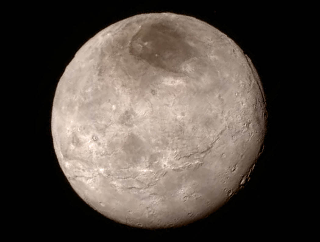
This image of Pluto's largest moon Charon, taken by NASA's New Horizons spacecraft 10 hours before its closest approach to Pluto on July 14, 2015 from a distance of 290,000 miles (470,000 kilometers), is a recently downlinked, much higher quality version of a Charon image released on July 15. Credit: NASA/Johns Hopkins University Applied Physics Laboratory/Southwest Research Institute.
This image of Pluto’s largest moon Charon, taken by NASA’s New Horizons spacecraft 10 hours before its closest approach to Pluto on July 14, 2015 from a distance of 290,000 miles (470,000 kilometers), is a recently downlinked, much higher quality version of a Charon image released on July 15. Credit: NASA/Johns Hopkins University Applied Physics Laboratory/Southwest Research Institute.

The New Horizons spacecraft is now about 5 billion kilometers (more than 3 billion miles) from Earth, and more than 69 million kilometers (43 million miles) beyond Pluto. The team says the spacecraft is healthy and all systems are operating normally.

You can see all the latest imagery sent back from New Horizons at this website. New images will be added every week, according to the New Horizons staff, likely on Fridays.

Additional reading: NASA press release.

New Horizons Team Delves into the Mystery of Charon’s “Red Pole”

Details of Pluto’s largest moon, Charon, are revealed in this image from New Horizons’ Long Range Reconnaissance Imager (LORRI), taken July 13, 2015, from a distance of 289,000 miles (466,000 kilometers), combined with color information obtained by New Horizons’ Ralph instrument on the same day. The distinctive red marking in Charon’s north polar region is currently being studied by scientists. Credit: NASA/Johns Hopkins University Applied Physics Laboratory/Southwest Research Institute)

As we await new imagery and data from the New Horizons’ flyby of the Pluto system to be transmitted to Earth, one piece of the Pluto-Charon puzzle that scientists are looking forward learning more about is the mysterious “dark pole” on Charon. Images sent immediately after the flyby reveal Charon’s north polar region is much darker than the lighter-colored material surrounding it, and it actually has a reddish cast to it.

The New Horizons team says the red pole appears to be a thin deposit of dark material over a distinct, sharply bounded, angular feature – perhaps and impact basin – and scientists hope to learn more by studying higher-resolution images that are currently being beamed back to Earth from the spacecraft.

Carly Howett, a senior research scientist at the Southwest Research Institute, is one of the scientists studying the mystery of what is causing this color difference and why it shows up at Charon’s north pole.

“Looking at Charon, it’s very clear that the northern polar region is much redder than the rest of the moon,” said Howett in a post on the New Horizons website. “Surfaces vary in color when something about them changes.”

So what is this red material? The leading theory right now is that material from Pluto’s atmosphere is falling to Charon and being ensnared in the polar region by what is known as “cold-trapping.”

It’s is so cold at Charon’s poles – temperatures there vary are just a tad warmer than absolute zero, between -433 and -351 °F (-258 and -213 °C) – that any gases settling there would freeze solid instead of escaping. And with the combination of extremely cold temperatures and solar radiation, the material is transformed to a new substance, and is being trapped on the pole. Howett said it likely won’t disappear with any seasonal changes on Charon.

“We know Pluto’s atmosphere is mainly nitrogen, with some methane and carbon monoxide,” she said, “so we expect that these same constituents are slowly coating Charon’s winter pole. The frozen ices would sublimate away again as soon as Charon’s winter pole emerges back into sunlight, except for one important detail: solar radiation modifies these ices to produce a new substance, which has a higher sublimation temperature and can’t sublimate and then escape from Charon.”

What is the new substance? Scientists can’t say for sure yet, but it might be a tholin.

Scientists at Johns Hopkins University’s Hörst Laboratory have produced complex chemical compounds called tholins, which may give Pluto its reddish hue. (Image credit: Chao He, Xinting Yu, Sydney Riemer, and Sarah Hörst, Johns Hopkins University).

What is a tholin? Tholins were first created in a laboratory by in the 1970s by Carl Sagan and his team at Cornell. According to planetary scientist Sarah Hörst, who wrote about tholins on The Planetary Society website, Sagan and his team would take mixtures of cosmically relevant gases and irradiate them with various energy sources. The result was “a brown, sometimes sticky, residue,” as Sagan described them in a paper he wrote in 1979.

Hörst said Sagan and team “were searching for answers to questions ranging from ‘why is the Great Red Spot red’ to ‘how did life on Earth originate’ and in the process produced material for which there was no name.”

They came up with the name “tholin,” and theorized that tholins could be a constituent of the Earth’s primitive oceans and therefore as relevant to the origin of life.

In the article Hörst wrote, “I have been studying tholin for almost a decade and in my experience the most frequently used synonyms for tholin are “gunk”, “brown gunk”, and “complex organic gunk”. Tholin is also often described as a “tar-like” substance. Words like tar, kerogen, bitumen, petroleum, asphalt, etc. all describe substances that are potentially similar to tholin in some ways. However, these materials all result from life; they are’biotic.’”

Charon approach from New Horizons. Credit: NASA/Damian Peach

Finding out more about what is going on at Charon’s north pole is indeed intriguing. Tholins might be the same material that give Pluto its reddish-brown hue in some regions, too.

Howett told Universe Today that the main instrument on New Horizons that will really pin down the compositional information is LEISA (Linear Etalon Imaging Spectral Array).

“This instrument observes 250 wavelengths between 1.25-2.5 microns, making it ideal for detecting the spectral signature of solid features,” she said via email. “We don’t know exactly the composition of the tholin on Charon (many different types are possible) but with LEISA we can look for differences in the spectra between the Charon’s anomalous red region and those surrounding it – to give us some hints of the change in surface composition and the “raw ingredients” for the tholin.”

For example, Howett said, maybe they’ll see more hydrogen cyanide (HCN) around the north pole region, which would open up a lot of complex chemistry options.

“We will start getting this data down in the next few weeks, so hopefully we’ll have some answers soon!” she said.

Further reading: New Horizons website, The Planetary Society

Get Ready for More Pluto Pics from New Horizons

Backlit by the sun, Pluto’s atmosphere rings its silhouette like a luminous halo in this image taken by NASA’s New Horizons spacecraft around midnight EDT on July 15. This global portrait of the atmosphere was captured when the spacecraft was about 1.25 million miles (2 million kilometers) from Pluto and shows structures as small as 12 miles across. The image, delivered to Earth on July 23, is displayed with north at the top of the frame. Credits: NASA/JHUAPL/SwRI

If you thought the New Horizons spacecraft flyby of the Pluto system happened waaaay too fast and you’re pining for more images and data, you are in luck. What the spacecraft has been able to send back so far is just the tip of the icy dwarf planet, so to speak.

Starting tomorrow, Saturday, September 5, 2015, the spacecraft will begin an “intensive” downlink session that will last for a year or more, sending back the tens of gigabits of data the spacecraft collected and stored on its digital recorders during the flyby. What will come first are “selected high priority” data-sets that the science team has been anxiously waiting for.

“This is what we came for – these images, spectra and other data types that are going to help us understand the origin and the evolution of the Pluto system for the first time,” said New Horizons Principal Investigator Alan Stern. “And what’s coming is not just the remaining 95 percent of the data that’s still aboard the spacecraft – it’s the best datasets, the highest-resolution images and spectra, the most important atmospheric datasets, and more. It’s a treasure trove.”

Can I get a fist pump, all you Plutophiles?

Plus, every Friday from here on out, you can count on getting new, unprocessed pictures from the Long Range Reconnaissance Imager (LORRI) on the New Horizons project website. Here’s where you can find the images, and the next LORRI set is scheduled for posting on Sept. 11, so set your calendars.

It’s been 7 weeks since New Horions’ historic flyby of the Pluto system, and during this quick pass, the spacecraft was designed “to gather as much information as it could, as quickly as it could, as it sped past Pluto and its family of moons – then store its wealth of data to its digital recorders for later transmission to Earth,” said the mission team.

A portrait from the final approach. Pluto and Charon display striking color and brightness contrast in this composite image from July 11, showing high-resolution black-and-white LORRI images colorized with Ralph data collected from the last rotation of Pluto. Color data being returned by the spacecraft now will update these images, bringing color contrast into sharper focus.  Credits: NASA-JHUAPL-SWRI
A portrait from the final approach. Pluto and Charon display striking color and brightness contrast in this composite image from July 11, showing high-resolution black-and-white LORRI images colorized with Ralph data collected from the last rotation of Pluto. Color data being returned by the spacecraft now will update these images, bringing color contrast into sharper focus. Credits: NASA-JHUAPL-SWRI

Why is it taking so long? The spacecraft runs on between 2-10 watts of power, and it had to prioritize on data collection during the flyby. The data has been stored on two onboard, solid-state, 8 gigabyte memory banks. The spacecraft’s main processor compresses, reformats, sorts and stored the data on a recorder, similar to a flash memory card for a digital camera.

One issue is the time it takes to get data from New Horizons as it speeds even farther away from Earth, past the Pluto system. Even moving at light speed, the radio signals from New Horizons containing data need more than 4 ½ hours to cover the 4 billion km (3 billion miles) to reach Earth.
But the biggest issue is the relatively low “downlink” rate at which data can be transmitted to Earth, especially when you compare it to rates now common for high-speed Internet surfers.

All communications with New Horizons – from sending commands to the spacecraft, to downlinking all of the science data from the historic Pluto encounter – happen through NASA’s Deep Space Network of antenna stations in (clockwise, from top left) Madrid, Spain; Goldstone, California, U.S.; and Canberra, Australia. Even traveling at the speed of light, radio signals from New Horizons need more than 4 ½ hours to travel the 3 billion miles between the spacecraft and Earth. Credit: NASA.

During the Jupiter flyby in February 2007, New Horizons data return rate was about 38 kilobits per second (kbps), which is slightly slower than the transmission speed for most computer modems. Now, after the flyby, the average downlink rate is going to be approximately 1-4 kilobits per second, depending on how the data is sent and which Deep Space Network antenna is receiving it. Sometimes, when possible, the spacecraft will be able to increase the rate by downlinking with both of its transmitters through NASA’s largest antennas of the DSN. But even then, it will take until late 2016 to send Pluto flyby data stored on the spacecraft’s recorders.

Patience you must have, my young padawan.

“The New Horizons mission has required patience for many years, but from the small amount of data we saw around the Pluto flyby, we know the results to come will be well worth the wait,” said Hal Weaver, New Horizons project scientist.

The data received by the DSN (you can watch the live data link happen on the Eyes of the Solar System DSN NOW page) will be sent to the New Horizons Mission Operations Center at the Applied Physics Lab a Johns Hopkins University, where data will be “unpacked” and stored. Then mission operations and instrument teams will scour the engineering data for performance trend information, while science data will be copied to the Science Operations Center at the Southwest Research Institute in Boulder, Colorado.

At the Science Ops Center, data will pass through “pipeline” software that converts the data from instrumental units to scientific units, based on calibration data obtained for each instrument. Both the raw and calibrated data files will be formatted for New Horizons science team members to analyze. Both the raw and calibrated data, along with various ancillary files (such as documents describing the pipeline process or the science instruments) will be archived at the Small Bodies Node of NASA’s Planetary Data System.

More info: New Horizons

What Did We Learn About Pluto?

What Did We Learn About Pluto?

We’ve only had blurry images of Pluto up until New Horizons. So what did we learn when we got up close and personal with Pluto and its moons?

Clyde Tombaugh first discovered Pluto in 1930. He saw only see a single speck of light moving slowly in front of the background stars as he flipped photographic plates back and forth. Sadly, this was the best anyone could do for decades. Even the mighty Hubble, the most sensitive instrument ever focused on Pluto, could only resolve a few grainy pixels.

It’s because Pluto is really really far away: 7.5 billion kilometers. Just the light alone from there takes over 4 hours to reach us. In order to get any more information, humanity needed to reach out and send a spacecraft to Pluto, and photograph it, up close and personal.

In 1989, Alan Stern and a group of planetary scientists began working on a mission. Their work culminated in NASA’s New Horizons spacecraft, launched in 2006, beginning a 9 and a half year journey. And unless you’ve been living in a lunar lava tube, you know that New Horizons finally reached its destination in mid July 2015, passing a narrow 12,472 kilometers above the surface.

For the very first time in human history, we saw a member of the Kuiper Belt right up in it’s business. And now I retire these old low quality images Pluto! Begone artist’s illustrations!

From here on out, we’re all about sick high def photos of the surface and its moons. I for one am going to revel in them for a while.

So fashion shoots aside, what did we actually learn about Pluto? The primary mission was to map the geography of Pluto and its biggest moon, Charon. It would study the surface chemistry of these icy worlds, and measure their atmospheres, if they even exist at all.

The mission had a few other objectives, and of course, planetary scientists knew that the spacecraft would just surprise us with stuff we never expected. Kuiper Belt objects like Pluto and Charon are ancient; geologists expected them to be pockmarked with craters, large and small.

Views of Pluto during New Horizons' approach. Credit: NASA/Damian Peach
Views of Pluto during New Horizons’ approach. Credit: NASA/Damian Peach

Surprisingly, New Horizons showed relatively smooth surfaces on both worlds. Pluto has a Texas-sized region newly named Sputnik Planum, where exotic ices flow like glaciers. Frozen nitrogen, carbon dioxide and methane ices act just like the ones we have here on Earth. We can see from the relative lack of craters that this process is still happening.

Pluto has mountains. Mountains! Close ups show a young range with peaks as high as 11,000 feet, or 3,500 meters. Here’s the crazy part. Those exotic chemicals that act like snow and ice? They’re not hard enough to make mountain peaks like this.

At extreme cold temperatures, water ice becomes as hard as rock. These mountains are made of ice, and they’re very young, probably less than 100 million years old. There could be plate tectonics on Pluto, but with ice, not rock. My mind is blown.

Pluto’s moon Charon has a huge chasm longer and deeper than the Grand Canyon in Arizona and although scientists hoped to see an atmosphere, the reality was beyond anyone’s expectations.

Backlit by the sun, Pluto’s atmosphere rings its silhouette like a luminous halo in this image taken by NASA’s New Horizons spacecraft around midnight EDT on July 15. This global portrait of the atmosphere was captured when the spacecraft was about 1.25 million miles (2 million kilometers) from Pluto and shows structures as small as 12 miles across. The image, delivered to Earth on July 23, is displayed with north at the top of the frame.  Credits: NASA/JHUAPL/SwRI
Backlit by the sun, Pluto’s atmosphere rings its silhouette like a luminous halo in this image taken by NASA’s New Horizons spacecraft around midnight EDT on July 15. This global portrait of the atmosphere was captured when the spacecraft was about 1.25 million miles (2 million kilometers) from Pluto and shows structures as small as 12 miles across. The image, delivered to Earth on July 23, is displayed with north at the top of the frame. Credits: NASA/JHUAPL/SwRI

New Horizons detected a thin nitrogen atmosphere at Pluto. It could be snowing nitrogen on Pluto right now. There could be faint winds, since there are regions on Pluto that look like they might have undergone weathering.

Take a look at this photograph as New Horizons zipped away. You can see the atmosphere clearly surrounding the dwarf planet, interacting with the solar wind and creating a tail that stretches away from the Sun.

Here’s my favorite thing we learned. Pluto is about 80 km larger than previous estimates, which makes it the largest Kuiper Belt Object found so far. Even bigger than Eris, which is still a little more massive. So maybe it’s time to revisit that Pluto planethood debate again. I’m just messing with you. No good will ever come from having that debate. It will only end in tears.

Interestingly, the data connection between Earth and New Horizons is tenuous. Possibly the worst internet since AOL. It can only transmit back about 1kb of data per second, which means that we’ll need to wait about 16 months for the photographs and data to be sent home during the first few days of the flyby.

As an extra bonus, this isn’t the last we’re going to hear from New Horizons. Because it’s so far away, as the spacecraft can only trickle data back to Earth. It’s going to take almost 2 years for all the images and measurements it gathered during its flyby to get back to Earth for scientists to study. Expect many more discoveries and announcements over the coming years, and more videos from us.

Now that Pluto has finally been explored, where do you think we should go next in the Solar System? Tell us in the comments below.

Ride Along with New Horizons on its Pluto Flyby

On July 14, 2015, after nine and a half years journeying across the Solar System, NASA’s New Horizons spacecraft made its historic close pass of Pluto and its moon Charon. Traveling a relative velocity of nearly 13.8 km/s (that’s almost 31,000 mph!) New Horizons passed through the Pluto system in a matter of hours but the views it captured from approach to departure held the world spellbound with their unexpected beauty. Those images and data – along with a bit of imagination – have been used by space imaging enthusiast Björn Jónsson to create an animation of New Horizons’ Pluto pass as if we were traveling along with the spacecraft – check it out above.

You can find more science images and discoveries about Pluto and Charon from New Horizons here, and see more renderings and animations by Jónsson on his website here.

What is the Oort Cloud?

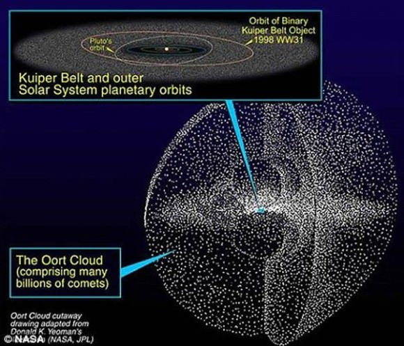
The layout of the solar system, including the Oort Cloud, on a logarithmic scale. Credit: NASA

For thousands of years, astronomers have watched comets travel close to Earth and light up the night sky. In time, these observations led to a number of paradoxes. For instance, where were these comets all coming from? And if their surface material vaporizes as they approach the Sun (thus forming their famous halos), they must formed farther away, where they would have existed there for most of their lifespans.

In time, these observations led to the theory that far beyond the Sun and planets, there exists a large cloud of icy material and rock where most of these comets come from. This existence of this cloud, which is known as the Oort Cloud (after its principal theoretical founder), remains unproven. But from the many short and long-period comets that are believed to have come from there, astronomers have learned a great deal about it structure and composition.

Definition:

The Oort Cloud is a theoretical spherical cloud of predominantly icy planetesimals that is believed to surround the Sun at a distance of up to around 100,000 AU (2 ly). This places it in interstellar space, beyond the Sun’s Heliosphere where it defines the cosmological boundary between the Solar System and the region of the Sun’s gravitational dominance.

Like the Kuiper Belt and the Scattered Disc, the Oort Cloud is a reservoir of trans-Neptunian objects, though it is over a thousands times more distant from our Sun as these other two. The idea of a cloud of icy infinitesimals was first proposed in 1932 by Estonian astronomer Ernst Öpik, who postulated that long-period comets originated in an orbiting cloud at the outermost edge of the Solar System.

In 1950, the concept was resurrected by Jan Oort, who independently hypothesized its existence to explain the behavior of long-term comets. Although it has not yet been proven through direct observation, the existence of the Oort Cloud is widely accepted in the scientific community.

Structure and Composition:

The Oort Cloud is thought to extend from between 2,000 and 5,000 AU (0.03 and 0.08 ly) to as far as 50,000 AU (0.79 ly) from the Sun, though some estimates place the outer edge as far as 100,000 and 200,000 AU (1.58 and 3.16 ly). The Cloud is thought to be comprised of two regions – a spherical outer Oort Cloud of 20,000 – 50,000 AU (0.32 – 0.79 ly), and disc-shaped inner Oort (or Hills) Cloud of 2,000 – 20,000 AU (0.03 – 0.32 ly).

The outer Oort cloud may have trillions of objects larger than 1 km (0.62 mi), and billions that measure 20 kilometers (12 mi) in diameter. Its total mass is not known, but – assuming that Halley’s Comet is a typical representation of outer Oort Cloud objects – it has the combined mass of roughly 3×1025 kilograms (6.6×1025 pounds), or five Earths.

Based on the analyses of past comets, the vast majority of Oort Cloud objects are composed of icy volatiles – such as water, methane, ethane, carbon monoxide, hydrogen cyanide, and ammonia. The appearance of asteroids thought to be originating from the Oort Cloud has also prompted theoretical research that suggests that the population consists of 1-2% asteroids.

Earlier estimates placed its mass up to 380 Earth masses, but improved knowledge of the size distribution of long-period comets has led to lower estimates. The mass of the inner Oort Cloud, meanwhile, has yet to be characterized. The contents of both Kuiper Belt and the Oort Cloud are known as Trans-Neptunian Objects (TNOs), because the objects of both regions have orbits that that are further from the Sun than Neptune’s orbit.

A belt of comets called the Oort Cloud is theorized to encircle the Solar system (image credit: NASA/JPL).

Origin:

The Oort cloud is thought to be a remnant of the original protoplanetary disc that formed around the Sun approximately 4.6 billion years ago. The most widely accepted hypothesis is that the Oort cloud’s objects initially coalesced much closer to the Sun as part of the same process that formed the planets and minor planets, but that gravitational interaction with young gas giants such as Jupiter ejected them into extremely long elliptic or parabolic orbits.

Recent research by NASA suggests that a large number of Oort cloud objects are the product of an exchange of materials between the Sun and its sibling stars as they formed and drifted apart. It is also suggested that many – possibly the majority – of Oort cloud objects were not formed in close proximity to the Sun.

Alessandro Morbidelli of the Observatoire de la Cote d’Azur has conducted simulations on the evolution of the Oort cloud from the beginnings of the Solar System to the present. These simulations indicate that gravitational interaction with nearby stars and galactic tides modified cometary orbits to make them more circular. This is offered as an explanation for why the outer Oort Cloud is nearly spherical in shape while the Hills cloud, which is bound more strongly to the Sun, has not acquired a spherical shape.

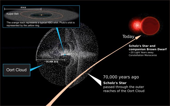
A comparison of the Solar System and its Oort Cloud. 70,000 years ago, Scholz's Star and companion passed along the outer boundaries of our Solar System (Credit: NASA, Michael Osadciw/University of Rochester)
A comparison of the Solar System and its Oort Cloud. 70,000 years ago, Scholz’s Star and companion passed along the outer boundaries of our Solar System. Credit: NASA, Michael Osadciw/University of Rochester

Recent studies have shown that the formation of the Oort cloud is broadly compatible with the hypothesis that the Solar System formed as part of an embedded cluster of 200–400 stars. These early stars likely played a role in the cloud’s formation, since the number of close stellar passages within the cluster was much higher than today, leading to far more frequent perturbations.

Comets:

Comets are thought to have two points of origin within the Solar System. They start as infinitesimals in the Oort Cloud and then become comets when passing stars knock some of them out of their orbits, sending into a long-term orbit that take them into the inner solar system and out again.

Short-period comets have orbits that last up to two hundred years while the orbits of long-period comets can last for thousands of years. Whereas short-period comets are believed to have emerged from either the Kuiper Belt or the scattered disc, the accepted hypothesis is that long-period comets originate in the Oort Cloud. However, there are some exceptions to this rule.

For example, there are two main varieties of short-period comet: Jupiter-family comets and Halley-family comets. Halley-family comets, named for their prototype (Halley’s Comet) are unusual in that although they are short in period, they are believed to have originated from the Oort cloud. Based on their orbits, it is suggested they were once long-period comets that were captured by the gravity of a gas giant and sent into the inner Solar System.

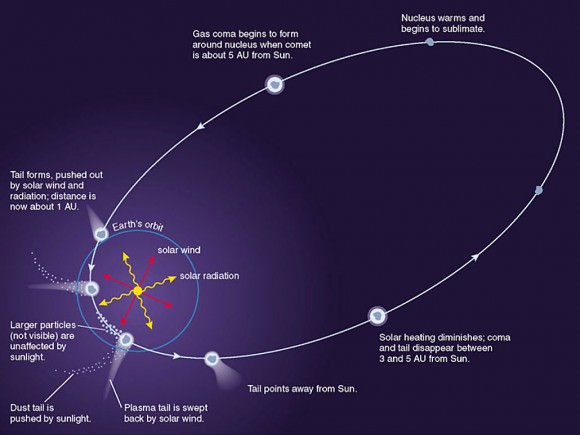
Evolution of a comet as it orbits the sun. Credit: Laboratory for Atmospheric and Space Sciences/ NASA

Exploration:

Because the Oort Cloud is so much farther out than the Kuiper Belt, the region remained unexplored and largely undocumented. Space probes have yet to reach the area of the Oort cloud, and Voyager 1 – the fastest and farthest of the interplanetary space probes currently exiting the Solar System – is not likely to provide any information on it.

At its current speed, Voyager 1 will reach the Oort cloud in about 300 years, and will will take about 30,000 years to pass through it. However, by around 2025, the probe’s radioisotope thermoelectric generators will no longer supply enough power to operate any of its scientific instruments. The other four probes currently escaping the Solar System – Voyager 2, Pioneer 10 and 11, and New Horizons – will also be non-functional when they reach the Oort cloud.

Exploring the Oort Cloud presents numerous difficulties, most of which arise from the fact that it is incredible distant from Earth. By the time a robotic probe could actually reach it and begin exploring the area in earnest, centuries will have passed here on Earth. Not only would those who had sent it out in the first place be long dead, but humanity will have most likely invented far more sophisticated probes or even manned craft in the meantime.

Still, studies can be (and are) conducted by examining the comets that it periodically spits out, and long-range observatories are likely to make some interesting discoveries from this region of space in the coming years. It’s a big cloud. Who knows what we might find lurking in there?

We have many interesting articles about the Oort Cloud and Solar System for Universe Today. Here’s an article about how big the Solar System is, and one on the diameter of the Solar System. And here’s all you need to know about Halley’s Comet and Beyond Pluto.

You might also want to check out this article from NASA on the Oort Cloud and one from the University of Michigan on the origin of comets.

Do not forget to take a look at the podcast from Astronomy Cast. Episode 64: Pluto and the Icy Outer Solar System and Episode 292: The Oort Cloud.

Reference:
NASA Solar System Exploration: Kuiper Belt & Oort Cloud